Embed Size (px)
Citation preview
TTALABAMA’S
FORESTSSPRING SPRING 20032003
• Alabama’s Forests Through Time
• Crop Tree Release in Hardwood Stands
• Using GPS in Beetle Detection
• Water Quality in Alabama
AA Publication of the Publication of the Alabama Forestry CommissionAlabama Forestry Commission
REASUREDREASURED

TIMOTHY C. BOYCE
State Forester
Ahistorical and monumental event took placerecently in north Alabama. This event will changeforestry in Alabama in the years to come. TheCenter for Forestry and Ecology program at
Alabama A&M University in Normal, Alabama, receivedaccreditation by the Society of American Foresters. Theybecame the first Historically Black College or University(HBCU) to be accredited by a professional forestry associa-tion.
In the past few years, the Alabama Forestry Commissionhas worked closely with administrators, faculty, and studentsto help make this happen. Our informal relationship began inthe 1976 school year. The relationship was formalized eightyears ago when one of our foresters was asked to serve onthe program’s curriculum committee. Four years ago, webecame a full partner in the forestry program’s Center ofExcellence. The Forestry and Ecology program has only threepartners, the U.S.D.A. Forest Service, the Alabama ForestryCommission, and International Paper.
A few years ago the Alabama Forestry Commission begana very active minority outreach program and students atAlabama A&M are a very important part of that program.The Commission has hired seven students from AlabamaA&M as summer interns and we currently have five forestersworking for us who were graduates of the forestry program.
In the past five years, Alabama A&M has graduated moreAfrican-American foresters than all other universities com-bined. With accreditation, many doors will be opened toAfrican-American foresters that were before closed. Theywill be able to apply to be registered foresters in Alabamaand other states that require registration as a requirement topractice forestry. They will also have better opportunities tocompete for places in graduate programs at other collegesand universities as well as have better opportunities withforestry industry and federal and state land managementagencies.
Congratulations to Alabama A&M University on youraccreditation. I continue to pledge the Alabama ForestryCommission’s support in this new chapter of our partnership.
2 / Alabama’s TREASURED Forests Spring 2003
Since September 11, 2001 we have watched numerousunits of our state’s National Guard and Reservesbeing called to active duty. First they answered thecall for homeland security and then to wars in far
away Afghanistan and Iraq. We have all seen the tearfulfarewells on television or passed the long green NationalGuard convoys on our roads and interstates and felt that lumprise in our throats.
Currently Alabama has around 7,000 National Guard andReserve troops deployed in “Operation Noble Eagle,” “Oper-ation Enduring Freedom,” and “Operation Iraqi Freedom.”Historically, Alabama and her sister southern states have sup-plied more soldiers than any other area of the country. ClayCounty in Alabama has the distinction of having more troopscurrently deployed than any other county in the nation.
These men and women represent the finest Alabama has tooffer. Before donning their camouflage and combat gear theywere little league coaches, Sunday school teachers, mayors,tradesmen, Girl Scout leaders, firefighters, policemen, andstore clerks. But more importantly they are also mothers andfathers, sisters and brothers, and sons and daughters.
It is now time for the rest of us to act in supporting oursoldiers. Although we can’t replace them and the jobs or rolesthey filled, we can pick up and carry on where they left offuntil their return. For many, it means finding a little moretime in the day, staying a little longer, arriving a little earlier,taking on another position or tackling a new task. It is alsoimportant that we show our support and respect for thesehometown heroes by lending our time and support to thefamily members left behind. Sometimes war can be thetoughest on those waiting at home.
In any trial or hardship our state has ever experienced,Alabamians have joined together in support and love for notonly our family and friends, but for the neighbors in our com-munity and even the unknown man or woman on the otherside of town. As Alabamians, we are not only known for ourhospitality, but for our compassionate hearts as well. I knowthat we will get through this time of trial and we will be bet-ter for it.
BOB RILEY
Governor, State of Alabama
A MESSAGE FROM . . .
Spring 2003 Alabama’s TREASURED Forests / 3
GovernorBob Riley
Alabama Forestry CommissionDavid Long, ChairmanGary Fortenberry, Vice ChairmanJohnny DennisTed DeVosCharlie HamiltonDennis HarborJerry Lacey
State ForesterTimothy C. Boyce
Assistant State ForesterRichard H. Cumbie
Administrative Division DirectorJerry Dwyer
Fire Division DirectorDavid Frederick
Management Division DirectorBruce Springer
Northwest RegionRegional Forester Wayne StrawbridgeAsst Reg Forester, Administration Bart WilliamsAsst Reg Forester, Programs Gerald Steeley
Northeast RegionRegional Forester Phearthur MooreAsst Reg Forester, Administration Charles HallAsst Reg Forester, Programs
Southeast RegionRegional Forester Franklin McAlileyAsst Reg Forester, Administration Dave DuckettAsst Reg Forester, Programs
Southwest RegionRegional Forester Gary ColeAsst Reg Forester, Administration Otis FrenchAsst Reg Forester, Programs Stanley Anderson
Editorial BoardBruce Springer Alabama Forestry CommissionDavid Frederick Alabama Forestry CommissionElishia Johnson Alabama Forestry CommissionDana McReynolds Alabama Forestry CommissionDon Stinson Alabama TREASURE Forest Assoc.Coleen Vansant Alabama Forestry Commission
EditorElishia Johnson
Managing EditorColeen Vansant
Vol. XXII, No. 2 Spring 2003
CONTENTS4 “Legacy Among the Live Oaks” by Madeline Hildreth
7 Alabama’s TREASURE Forest Certifications by County
8 Alabama’s Forests Through Time by Jim Lacefield
13 Crop Tree Release in Pre-Commercial Hardwood Stands by David Mercker
15 Hardwood Surpasses Pine as Tree of Choice in Southern Timber Markets by Betsy Bates
16 Finding Those Bugs: Using Global Positioning Systems in Southern Pine Beetle Detection by Jim Hyland
18 Water Quality in Alabama: The Role of the Alabama Forestry Commission by Tim Albritton and Jim Hyland
22 Intersection and Resection by Douglas A. Smith
24 “Red Skies and Sun Dogs - Mares’ Tails and August Fogs”Predicting Weather the Old-Fashioned Way by Coleen Vansant
27 Crops Planted in Spring and Early Summer Attract Doves in the Fall by Tim Cosby and Keith Guyse
28 West Nile Virus in Alabama by Coleen Vansant
30 The Outreach Advisory Council: Another Step Towards Outreach Success by Dana McReynolds
DEPARTMENTS2 Message from the Governor and the State Forester
12 Hidden Treasure: Cane Creek Canyon Wildlife Preserve by Tilda Mims
20 Threatened and Endangered Species: The Red Wolf (Canus rufus): Extinct in Alabama by John Dickson
32 Trees of Alabama: Cedar of Lebanon by Tilda Mims
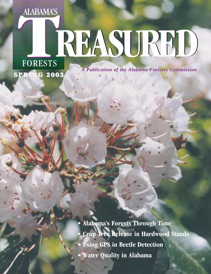
COVER: A sure sign of Springtime in the Deep South - Acres of Mountain Laurelgrace the TREASURE Forest of Robert and Carol Pittman in Mobile County.
Photo by Elishia Johnson
Alabama’s TREASURED Forests (ISSN 0894-9654) is published quarterly by the Alabama ForestryCommission, 513 Madison Avenue, Montgomery, AL 36130. Telephone (334) 240-9355. Bulk rate postagepaid at Montgomery, Alabama. POSTMASTER: Send address changes to: Alabama’s TREASUREDForests, P.O. Box 302550, Montgomery, AL 36130-2550. Web site: www.forestry.state.al.us
Alabama Forestry Commission policy prohibits discrimination based on race, color, national origin, sex,age, religion or handicapping condition.
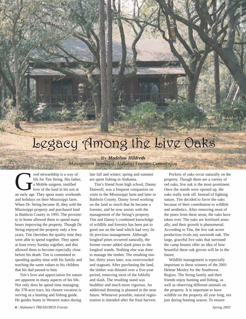
Good stewardship is a way oflife for Tim String. His father,a Mobile surgeon, instilledlove of the land in his son at
an early age. They spent many weekendsand holidays on their Mississippi farm.When Dr. String became ill, they sold theMississippi property and purchased landin Baldwin County in 1995. The proximi-ty to home allowed them to spend manyhours improving the property. Though Dr.String enjoyed the property only a fewyears, Tim cherishes the quality time theywere able to spend together. They spentat least every Sunday together, and thisallowed them to become especially closebefore his death. Tim is committed tospending quality time with his family andteaching the same values to his childrenthat his dad passed to him.
Tim’s love and appreciation for natureare apparent in many aspects of his life.Not only does he spend time managingthe 378-acre tract, his chosen vocation isserving as a hunting and fishing guide.He guides hunts in Western states during
late fall and winter; spring and summerare spent fishing in Alabama.
Tim’s friend from high school, DannyDunwell, was a frequent companion onvisits to the Mississippi farm and later toBaldwin County. Danny loved workingon the land so much that he became aforester, and he now assists with themanagement of the String’s property.Tim and Danny’s combined knowledgeof wildlife and forestry has been put togood use on the land which had very lit-tle previous management. Althoughlongleaf pines occurred naturally, the former owner added slash pines to thelongleaf stands. Nothing else was doneto manage the timber. The resulting tim-ber, thirty years later, was overcrowdedand stagnant. After purchasing the land,the timber was thinned over a five-yearperiod, removing most of the loblollyand slash. The resulting stand washealthier and much more vigorous. Anadditional thinning is planned in the nearfuture. Whenever possible, natural regen-eration is intended after the final harvest.
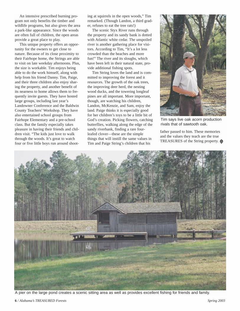
Pockets of oaks occur naturally on theproperty. Though there are a variety ofred oaks, live oak is the most prominent.Once the stands were opened up, theoaks really took off. Instead of fightingnature, Tim decided to favor the oaksbecause of their contribution to wildlifeand aesthetics. After removing most ofthe pines from these areas, the oaks havetaken over. The oaks are fertilized annu-ally, and their growth is phenomenal.According to Tim, the live oak acornproduction rivals any sawtooth oak. Thelarge, graceful live oaks that surroundthe camp houses offer an idea of howbeautiful these oak groves will be in thefuture.
Wildlife management is especiallyimportant to these winners of the 2001Helene Mosley for the SouthwestRegion. The String family and theirfriends enjoy hunting and fishing, aswell as observing different animals onthe property. It is important to havewildlife on the property all year long, notjust during hunting season. To ensure
4 / Alabama’s TREASURED Forests Spring 2003
By Madeline HildrethManagement Specialist, Alabama Forestry Commission
Pho
to b
y M
adel
ine
Hild
reth
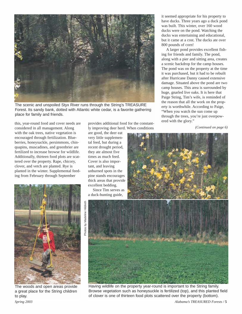
this, year-round food and cover needs areconsidered in all management. Alongwith the oak trees, native vegetation isencouraged through fertilization. Blue-berries, honeysuckle, persimmons, chin-quapins, muscadines, and greenbrier arefertilized to increase browse for wildlife.Additionally, thirteen food plots are scat-tered over the property. Rape, chicory,clover, and vetch are planted. Rye isplanted in the winter. Supplemental feed-ing from February through September
provides additional food for the constant-ly improving deer herd. When conditionsare good, the deer eatvery little supplemen-tal feed, but during arecent drought period,they ate almost fivetimes as much feed.Cover is also impor-tant, and leavingunburned spots in thepine stands encouragesthick areas that provideexcellent bedding.
Since Tim serves asa duck-hunting guide,
it seemed appropriate for his property tohave ducks. Three years ago a duck pondwas built. This winter, over 160 woodducks were on the pond. Watching theducks was entertaining and educational,but it came at a cost. The ducks ate over800 pounds of corn!
A larger pond provides excellent fish-ing for friends and family. The pond,along with a pier and sitting area, createsa scenic backdrop for the camp houses.The pond was on the property at the timeit was purchased, but it had to be rebuiltafter Hurricane Danny caused extensivedamage. Situated above the pond are twocamp houses. This area is surrounded byhuge, gnarled live oaks. It is here thatPaige String, Tim’s wife, is reminded ofthe reason that all the work on the prop-erty is worthwhile. According to Paige,“When you watch the sun come upthrough the trees, you’re just overpow-ered with the glory.”
Spring 2003 Alabama’s TREASURED Forests / 5
(Continued on page 6)
The woods and open areas providea great place for the String childrento play.
Pho
tos
by M
adel
ine
Hild
reth
Having wildlife on the property year-round is important to the String family.Browse vegetation such as honeysuckle is fertilized (top), and this planted fieldof clover is one of thirteen food plots scattered over the property (bottom).
The scenic and unspoiled Styx River runs through the String’s TREASUREForest. Its sandy bank, dotted with Atlantic white cedar, is a favorite gatheringplace for family and friends.
6 / Alabama’s TREASURED Forests Spring 2003
An intensive prescribed burning pro-gram not only benefits the timber andwildlife programs, but also gives the areaa park-like appearance. Since the woodsare often full of children, the open areasprovide a great place to play.
This unique property offers an oppor-tunity for the owners to get close tonature. Because of its close proximity totheir Fairhope home, the Strings are ableto visit on late weekday afternoons. Plus,the size is workable. Tim enjoys beingable to do the work himself, along withhelp from his friend Danny. Tim, Paige,and their three children also enjoy shar-ing the property, and another benefit ofits nearness to home allows them to fre-quently invite guests. They have hostedlarge groups, including last year’sLandowner Conference and the BaldwinCounty Teachers’ Workshop. They havealso entertained school groups fromFairhope Elementary and a pre-schoolclass. But the family especially takespleasure in having their friends and chil-dren visit. “The kids just love to walkthrough the woods. It’s great to watchfour or five little boys run around shoot-
ing at squirrels in the open woods,” Timremarked. (Though Landon, a third grad-er, refuses to eat the tree rats!)
The scenic Styx River runs throughthe property and its sandy bank is dottedwith Atlantic white cedar. The unspoiledriver is another gathering place for visi-tors. According to Tim, “It’s a lot lesscrowded than the beaches and morefun!” The river and its sloughs, whichhave been left in their natural state, pro-vide additional fishing spots.
Tim String loves the land and is com-mitted to improving the forest and itresources. The growth of the oak trees,the improving deer herd, the nestingwood ducks, and the towering longleafpines are all important. More important,though, are watching his children,Landon, McKenzie, and Sam, enjoy theland. Paige thinks it is especially goodfor her children’s toys to be a little bit ofGod’s creation. Picking flowers, catchingbutterflies, walking along the edge of thesandy riverbank, finding a rare four-leafed clover—these are the simplethings that will instill the same values inTim and Paige String’s children that his
father passed to him. These memoriesand the values they teach are the trueTREASURES of the String property.
A pier on the large pond creates a scenic sitting area as well as provides excellent fishing for friends and family.
Pho
tos
by M
adel
ine
Hild
reth
Tim says live oak acorn productionrivals that of sawtooth oak.
Spring 2003 Alabama’s TREASURED Forests / 7
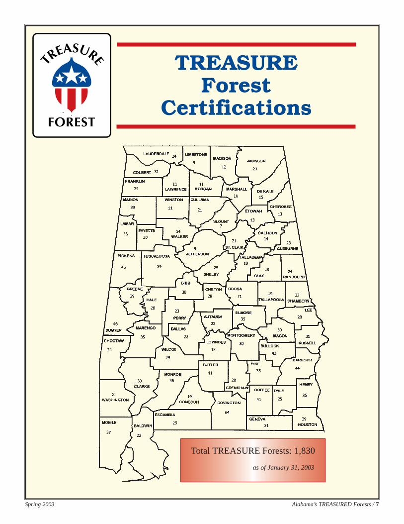
TREASURE Forest
Certifications
Total TREASURE Forests: 1,830
as of January 31, 2003
8 / Alabama’s TREASURED Forests Spring 2003
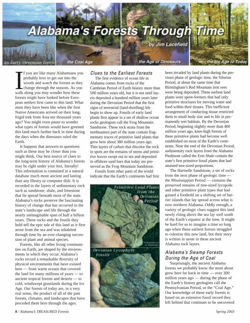
If you are like many Alabamians youprobably love to get out into thewoods and watch the forests as theychange through the seasons. As you
walk along you may wonder how theseforests might have looked before Euro-pean settlers first came to this land. Whatmust they have been like when the firstNative Americans arrived on their long,frigid trek from Asia ten thousand yearsago? You might even pause to wonderwhat types of forests would have greenedthis land much farther back in time duringthe days when the dinosaurs ruled theEarth.
It happens that answers to questionssuch as these may be closer than youmight think. Our best source of clues tothe long-term history of Alabama’s forestsmay be right under your feet, literally!This information is contained in a naturaldatabase much more ancient and lastingthan any library or computer disk. It isrecorded in the layers of sedimentary rocksuch as sandstone, shale, and limestonethat lie spread beneath most of the state.Alabama’s rocks preserve the fascinatinghistory of change that has occurred in thestate’s landscape and life through thenearly unimaginable span of half a billionyears. These rocks and the fossils theyhold tell the epic tale of this land as it firstarose from the sea and was inhabitedthrough time by an ever-changing succes-sion of plant and animal species.
Forests, like all other living communi-ties on Earth, are shaped by the environ-ments in which they occur. Alabama’srocks record a remarkable diversity ofphysical environments that have existedhere — from warm oceans that coveredthe land for many millions of years — toancient tropical forests and deserts — tocold, windswept grasslands during the IceAge. Our forests of today are, in a veryreal sense, the product of all of the pastforests, climates, and landscapes that havepreceded them here through the ages.
Clues to the Earliest ForestsClues to the Earliest ForestsThe first evidence of ocean life in
Alabama comes from rocks of theCambrian Period of Earth history more than500 million years old, but it is not until lay-ers deposited a hundred million years laterduring the Devonian Period that the firstsigns of terrestrial (land-dwelling) lifebegin to show up. Fossils of early landplants first appear in a set of shallow oceanrocks geologists call the Frog MountainSandstone. These rock strata from thenortheastern part of the state contain frag-mentary traces of primitive land plants thatgrew here about 380 million years ago.Thin layers of carbon that discolor the rockin spots are the remains of stems and primi-tive leaves swept out to sea and depositedin offshore sand bars that today are pre-served as the Frog Mountain Sandstone.
Fossils from other parts of the worldindicate that the Earth’s continents had first
been invaded by land plants during the pre-vious phase of geologic time, the SilurianPeriod, at about the same time thatBirmingham’s Red Mountain iron oreswere being deposited. These earliest landplants were spore-formers that had onlyprimitive structures for moving water andfood within their tissues. This inefficientarrangement of conducting tissue restrictedthem to small body size and to life in per-manently wet habitats. By the DevonianPeriod, beginning slightly more than 400million years ago, knee-high forests ofthese primitive plants had become wellestablished on most of the Earth’s conti-nents. Near the end of the Devonian Period,sedimentary rock layers from the AlabamaPiedmont called the Erin Shale contain thestate’s first primitive fossil plants that hadattained tree-sized proportions.
The Hartselle Sandstone, a set of rocksfrom the next phase of geologic time —the Mississippian Period — contains thepreserved remains of tree-sized lycopodsand other primitive plant types that hadgained a foothold on a shifting set of bar-rier islands that lay spread across what isnow northern Alabama. Oddly enough, avariety of geologic clues suggest this landnewly rising above the sea lay well southof the Earth’s equator at the time. It mightbe hard for us to imagine a time so longago when these earliest forests struggledto colonize this new land, but their storyis written in stone in these ancientAlabama rock layers.
Alabama’Alabama’s Swamp Forests s Swamp Forests During the Age of CoalDuring the Age of Coal
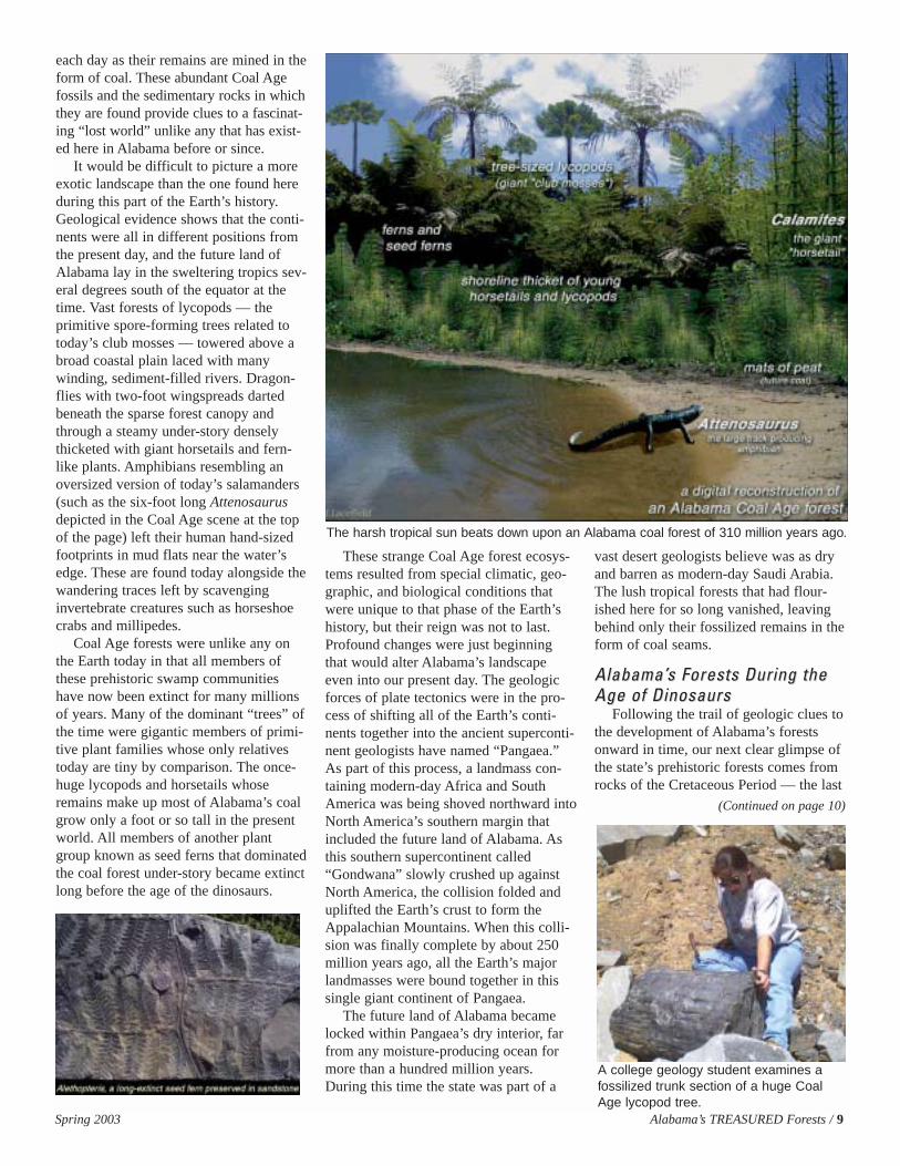
Surprisingly, the ancient Alabamaforests we probably know the most aboutgrew here far back in time — over 300million years ago — during the phase ofthe Earth’s history geologists call thePennsylvanian Period, or the “Coal Age.”Our knowledge of these early forests isbased on an extensive fossil record theyleft behind that continues to be uncovered
Spring 2003 Alabama’s TREASURED Forests / 9
each day as their remains are mined in theform of coal. These abundant Coal Agefossils and the sedimentary rocks in whichthey are found provide clues to a fascinat-ing “lost world” unlike any that has exist-ed here in Alabama before or since.
It would be difficult to picture a moreexotic landscape than the one found hereduring this part of the Earth’s history.Geological evidence shows that the conti-nents were all in different positions fromthe present day, and the future land ofAlabama lay in the sweltering tropics sev-eral degrees south of the equator at thetime. Vast forests of lycopods — theprimitive spore-forming trees related totoday’s club mosses — towered above abroad coastal plain laced with manywinding, sediment-filled rivers. Dragon-flies with two-foot wingspreads dartedbeneath the sparse forest canopy andthrough a steamy under-story denselythicketed with giant horsetails and fern-like plants. Amphibians resembling anoversized version of today’s salamanders(such as the six-foot long Attenosaurusdepicted in the Coal Age scene at the topof the page) left their human hand-sizedfootprints in mud flats near the water’sedge. These are found today alongside thewandering traces left by scavenginginvertebrate creatures such as horseshoecrabs and millipedes.
Coal Age forests were unlike any onthe Earth today in that all members ofthese prehistoric swamp communitieshave now been extinct for many millionsof years. Many of the dominant “trees” ofthe time were gigantic members of primi-tive plant families whose only relativestoday are tiny by comparison. The once-huge lycopods and horsetails whoseremains make up most of Alabama’s coalgrow only a foot or so tall in the presentworld. All members of another plantgroup known as seed ferns that dominatedthe coal forest under-story became extinctlong before the age of the dinosaurs.
These strange Coal Age forest ecosys-tems resulted from special climatic, geo-graphic, and biological conditions thatwere unique to that phase of the Earth’shistory, but their reign was not to last.Profound changes were just beginningthat would alter Alabama’s landscapeeven into our present day. The geologicforces of plate tectonics were in the pro-cess of shifting all of the Earth’s conti-nents together into the ancient superconti-nent geologists have named “Pangaea.”As part of this process, a landmass con-taining modern-day Africa and SouthAmerica was being shoved northward intoNorth America’s southern margin thatincluded the future land of Alabama. Asthis southern supercontinent called“Gondwana” slowly crushed up againstNorth America, the collision folded anduplifted the Earth’s crust to form theAppalachian Mountains. When this colli-sion was finally complete by about 250million years ago, all the Earth’s majorlandmasses were bound together in thissingle giant continent of Pangaea.
The future land of Alabama becamelocked within Pangaea’s dry interior, farfrom any moisture-producing ocean formore than a hundred million years.During this time the state was part of a
vast desert geologists believe was as dryand barren as modern-day Saudi Arabia.The lush tropical forests that had flour-ished here for so long vanished, leavingbehind only their fossilized remains in theform of coal seams.
Alabama’Alabama’s Forests During the s Forests During the Age of DinosaursAge of Dinosaurs
Following the trail of geologic clues tothe development of Alabama’s forestsonward in time, our next clear glimpse ofthe state’s prehistoric forests comes fromrocks of the Cretaceous Period — the last
The harsh tropical sun beats down upon an Alabama coal forest of 310 million years ago.
(Continued on page 10)
A college geology student examines afossilized trunk section of a huge CoalAge lycopod tree.
10 / Alabama’s TREASURED Forests Spring 2003
part of the Age of Dinosaurs. Before this,however, there is a huge gap in Alabama’ssurface rocks, known to geologists as anunconformity that spans more than 200million years. This gap separates the lay-ers formed during the Coal Age fromthose that lie above them derived fromthis much later part of the Earth’s history.These tell-tale “missing pages” of thegeologic record are believed to representroughly the length of time Alabama wasuplifted and locked within the dry, moun-tainous terrain of Pangaea. Little newrock was deposited, and much of theland’s surface was undoubtedly removedby erosion during this time. It was longthought that there might be no rocks leftanywhere in the state that might provideinformation about this once-hidden part ofthe state’s history.
Recently, tantalizing clues to these lostyears of Alabama’s past have been uncov-ered, but they come from rock layers nowburied nearly five miles down beneath thesouthern part of the state. Deep drillingused to probe for natural gas resources hasdiscovered unique sedimentary layersdeposited in desert-like rift valleys thatexisted here as Pangaea first began tobreak apart during the Triassic Period,around 220 million years ago. As the conti-nents rifted apart and the Gulf of Mexicofirst began to form, the land subsided andthick layers of sediment washed in fromthe north to bury these arid rift basins thatdate to the early days of the dinosaurs. Onrare occasions fossilized bits of primitiveplants called “cycads” that resembled smallpalm trees are brought to the surface indrilling cores extracted from these deepholes. Both these dry-adapted fossil plantsand the unique sediments in which they arefound suggest that even into the next partof dinosaur times known as the JurassicPeriod, Alabama’s climate was dry and thelandscape probably only thinly vegetated.Again, it may be hard for us today toimagine a time when Alabama’s environ-ment and life were so different from thepresent day. These rocks buried so deepbeneath South Alabama now supply a fewof the key missing pieces to the strangepuzzle that is the history of this land.
As the Gulf of Mexico basin firstbegan to fill with ocean waters during theJurassic Period around 190 million yearsago, lush, tropical forests probably rede-
veloped in Alabama in response to thenew source of moisture. We don’t havemuch information about these Jurassicforests or of the dinosaurs that must havewalked them, because Alabama’s rocksdating to this period lie deep undergroundand were deposited in ocean, not land,environments. Alabama’s richest oil reser-voir, the Smackover Formation, wasformed on the floor of the young, expand-ing Gulf of Mexico during this time.
Geologic evidence of Alabama’s foresthistory resumes again in rock layersdeposited late in the Cretaceous Period,about 90 million years ago. Sea levelswere very high, and a set of soft rocksgeologists call the Tuscaloosa Group indi-cates that the state’s coastline was farinland from the present one. The Gulfshoreline of the time ran from nearAuburn in the east, to just north of thepresent-day cities of Montgomery andTuscaloosa, then curved northward toslightly west of the Muscle Shoals area.Sediments of the Tuscaloosa Group areimportant in that they hold the first fossilleaves and petrified wood from a newplant group that would change the face ofAlabama’s forests forever. These newplants were the angiosperms, or floweringplants. During this part of Earth historyflowering plants were spreading to be-
come the dominant plant group through-out the world. Today they include over 90per cent of all living plant species.
As always, our knowledge of theseCretaceous Period forests comes from thetypes of plant fossils we find in rocksfrom the time. Fossils collected from thesedimentary layers of the TuscaloosaGroup include at least 187 species of fos-sil plants with 23 species of the cone-bearing gymnosperms, such as thecypress, and 152 species of floweringplants. Fossil leaves include ones frommagnolias, laurels, figs, and Araucarites,a relative of today’s Norfolk Island Pine.
Plant fossils also provide importantclues to Alabama’s climate during thisperiod. A special type of fossil angiospermwood known as Paraphyllanthoxylon,with living relatives found only in theBrazilian rain forest, helps biologists toconclude that the Late Cretaceous climatein Alabama was still tropical in nature,with adequate rainfall for thick forestdevelopment. This particular type of fos-silized wood has almost no annual ringstructure, suggesting very little seasonaldifferences in the climate. Another line ofevidence to Alabama’s Cretaceous Periodclimate has been derived from study ofthe percentage of this fossil flora thathave entire (smooth) leaf margins.
(Inset:) A college paleontology class collects fossilized leaves preserved in a dinosaur-age clay layer near Auburn. These leaves probably fell into a shallow, oxygen-poorcoastal pond such as the one depicted in the reconstructed scene above.
Alabama’s Forests Through Time(Continued from page 9)
Spring 2003 Alabama’s TREASURED Forests / 11
Geologists studying past climates havebeen able to use this key characteristic ofleaf structure to reconstruct the climate-related ecology of past forests with goodsuccess.
The Development of Alabama’The Development of Alabama’ssModern Forest CommunitiesModern Forest Communities
Even after the days of the dinosaursended 65 million years ago in a sudden,catastrophic change in climate probablybrought on by a large asteroid’s impactwith the Earth, evidence shows Alabama’sforests continued to have tropical charac-teristics for millions of years. Dominanttree species as well as clues to the state’sclimate during this time frame that geolo-gists call the Tertiary Period can be deter-mined from fossils found in the rock lay-ers from the time.
One special type of sedimentarydeposit has been especially useful in pro-viding clues to this portion of the state’shistory. These are the layers of lignite, orbrown coal, found in east-west bands run-ning parallel to the Tertiary Period coast-line across south Alabama. Soft lignitecoal is produced under similar environ-mental conditions to the much older coalsformed during the Pennsylvanian Period,but they come from different plant speciesand result from different degrees of chem-ical change in the original plant material,called peat. These layers were never asdeeply buried and therefore did not under-go as much chemical alteration.
Though these lignites will probablynever have great economic value theycontain important clues to the Alabamaenvironment of about 50 million yearsago. Plant fragments and fossilized pollenfound in these lignites help to show theclimate of coastal Alabama during thistime. Oaks, hickories and walnuts, palms,tupelos, swamp cyrilla, water elms, andhollies are some of the broadleaf treespecies preserved in the lignites. Coniferpollen includes that of cypress, dawn red-wood, and a very few pine species thatwere just starting to make their appear-ance in Alabama forests. The presence ofseveral tropical tree species suggests thatthe climate during this time was stillwarmer than that of the present, moist andwith milder wintertime temperatures.
Alabama’s forests had gained most ofthe tree families we find here today by theMiocene Epoch, about 20 million yearsago. These forest communities wouldappear familiar to us even though the
individual species of these trees wouldcontinue to change. A global shift towardcooler climate that had begun about 35million years ago had driven all of thetropical species southward, and deciduoustrees such as oaks and hickories hadbecome the dominant forest types.
A dramatic change in the world’s cli-mate beginning about two million yearsago wrought far-reaching effects onAlabama’s forest communities. Theresults of this climate change can still beseen in the composition of Alabamaforests even today. This infamous naturalevent was the “Ice Age,” also referred toas the Pleistocene Epoch of geologic his-tory. Even though Alabama’s landscapehad largely reached its present form bythis time the state’s climate and life dur-ing the period were quite unlike today.
The Earth’s Ice Age climate was muchcolder than average and glaciers up to twomiles thick covered large areas of thenorthern continents. Massive ice sheetsspread and then retreated many times overthe last two million years. Glacial ice inNorth America advanced only as far southas the Ohio River Valley, and therefore,never came closer than several hundredmiles to Alabama. Even this distance,though, was near enough to severely alterthe state’s biological communities. HugeIce Age beasts such as mammoths,mastodons, giant bison, camels andground sloths roamed the forests andgrasslands of Ice Age Alabama. At timessea levels were so low due to the volumeof the Earth’s water locked up in the ice-caps that these animals could have grazed60 miles south of Alabama’s presentcoastline out onto the continental shelf.
Information on Alabama’s Ice Ageforests has come from several unusualsources. Among the most informative of
these has been the study of fossil pollengrains contained in core samples fromspecial, undisturbed environments such asupland bogs and sinkholes. These pollensamples along with others from the east-ern United States show that as glaciersadvanced southward, vegetation zonesshifted south with them. North Alabamathen lay in a transition zone of northernhardwoods and evergreens such as hem-lock and spruce similar to that found insouthern Canada today. To the south wereopen forests of drought-tolerant treesinterspersed with prairie-like grasslands.These studies suggest that this climaticdisruption lasted until so recently thatAlabama forests may still be in the pro-cess of recovering from the Ice Age, withmany tree species slowly migrating backnorthward through the forests even intothe present day.
Each glacial period was separated bybrief, warm interglacial periods. Manyscientists believe we may still be in theIce Age and that glaciers will one dayreturn. Our current interglacial period,called the Holocene Epoch, has lastedapproximately 10,000 years. All of humancivilization, written language, agriculture,and technology above the level of stonetools has come about in this geologicallybrief span of time.
From this thumbnail sketch of the his-tory of Alabama forests it is easy to seethat many factors have molded this landand its life through the ages. However,one new force today shapes our forestsmore than all others. Since humans firstarrived here, man has been the mostimportant force in forest change. The carewe exercise in managing our forests willdetermine in large part our future qualityof life and success in this land.
12 / Alabama’s TREASURED Forests Spring 2003
In the Little Mountains region ofColbert County, Jim and FayeLacefield’s family developed CaneCreek Canyon Nature Preserve, a
323-acre scenic natural area. For them itwas a commitment to provide sanctuaryfor native plants and animals.
They purchased the first 40 acres withan unexpected inheritance. Over time,adjoining tracts containing Cane Creekand Devil’s Hollow were added for atotal of 413 acres certified under theTREASURE Forest program. Recreationand environmental education are themanagement objectives for the family.
Dr. James Lacefield teaches biologyand earth science at the University ofNorth Alabama, and has a special inter-est in paleobiology and paleoecology. Heand his wife, Faye, also an educator,quickly recognized the area’s unique nat-ural history. They decided to preserve itand, perhaps more importantly, share itwith schools, scouts, families, clubs, andothers at no charge.
The rugged and varied topographyprovides a wide range of habitats anddiverse natural communities. Canyons,waterfalls, rock shelters, and giant boul-ders create many special microhabitatsand microclimates that allow a numberof rare plant species to live here. A vari-ety of soil types and environments areideal to support an unusually diverse for-est community.
Opportunities for visitors to thiswildlife preserve rival any park or recre-ation area in the southeast.
Nearly ten miles of hiking trails pro-vide routes to many scenic sites andoverlooks. A four-wheel drive road per-mits access for elderly or handicappedvisitors to many areas. Concrete bridgesusing rock and natural pigments blendinto the environment, allowing hikers tocross streams.
Several well-maintained campingsites and picnicking spots are available.
Self-guided tree identification listsinclude common and scientific names ofmore than a hundred species of nativetrees and a few rare types.
Many rare and endangered plantspecies occur on the preserve. Theseinclude: Allegheny spurge, wild ginseng,several orchids, the giant columbo, tworare filmy ferns, and the little flood plainplant, Jamesianthus.
Thousands of native azaleas, includ-ing many natural hybrid forms are foundhere. Mountain laurel, yellow lady’s slip-per, showy orchids, trout lily, trailingarbutus, and a variety of otherAppalachian species also appear thatthrive in rich forest habitats and coves.One unusual type of wildflower commu-nity is found growing on giant bouldersfar above the forest floor. Many speciesin these special environments bloomweeks before their relatives growingbelow on the ground.
The first reported identification ofFrench’s Shooting Star, one ofAlabama’s rarestand most unusualwildflowers, wasdiscovered here in1988. The closestother colonies arelocated more than300 miles away inthe BostonMountains ofArkansas. Smallcolonies are alsofound in Illinois,Pennsylvania,Minnesota, andWisconsin, alwaysgrowing in sandysoil weatheredfrom sandstone
overhang above, in a protected stripwhere few other plants compete with it.
Each year many families, friends, andindividuals enjoy camping, hiking, andpicnicking on the preserve, taking fulladvantage of the Lacefield’s gracious giftto the community. Garden and wildflowerclubs, scout troops, and local schools andcolleges are also frequent visitors. Sinceopening the not-for-profit Cane CreekCanyon Nature Preserve in 1986, theyhave averaged 700 visits per year!
Forest ownership is an excellentinvestment, but its dividends can bemore than the type you put in the bank.For the Lacefields, seeing Cane CreekPreserve enjoyed by so many is rewardenough. “It is both a personal and politi-cal statement that places such as thisneed to be preserved,” says Dr.Lacefield. “The government can’t do itall, so private landowners must take anactive part.”
Cane Creek Preserve is open year-round and the welcome mat is alwaysout.
Cane Creek Canyon Wildlife PreserveBy Tilda Mims
Information Specialist, Alabama Forestry Commission
Spring 2003 Alabama’s TREASURED Forests / 13
The length of time necessary togrow quality hardwood trees isperhaps the greatest deterrentpreventing private landowners
from practicing hardwood management.Valuable trees such as white and redoaks, cherry, ash, yellow poplar, andblack walnut require decades to reachfinancial maturity. This article describeshow to accelerate growth rates in youryoung hardwood forest, which is vital tokeeping your interest alive during thecritical and dynamic time betweenseedling establishment and final harvest.
Timber Stand Improvement (TSI) is aforest management tool used to enhancegrowth rates of timber and shorten thetime required for hardwood crops tomature. TSI provides an opportunity for
you to become actively involved in man-aging your timber, while increasing thepossibility of a more favorable financialreturn.
Defining TSI and Crop Tree Release
TSI is controlling, manipulating, andimproving the growth, quality, andspecies composition of a timber stand.One method of TSI is Crop Tree Release(CTR), the practice of deadening select-ed trees in younger, overstocked forestsfor the benefit of releasing desirable croptrees. Overstocked indicates a foreststand having more trees than is desired,causing the growth rate on individualtrees to decline. CTR can be used to alterspecies composition within the forest,
and to concentrate diameter growth ondesirable, potentially valuable crop trees.When applied properly, CTR results in afaster-growing, healthier woodland com-posed of a greater percentage of moreacceptable trees. Similar to the principlesapplied to gardening, CTR allows you toguide your forest, leaving it with well-spaced crop trees whose crowns arecapable of rapidly responding toincreased growing space. CTR can befirst applied to younger, pre-commercialstands (trees that are too small for mar-ket), with diameters ranging from 4 to 8inches (measured at 4.5 feet above theground).
(Continued on page 14)
(Part I of a two-part article)
By David MerckerForestry, Wildlife, and Fisheries; University of Tennessee Agricultural Extension Service
14 / Alabama’s TREASURED Forests Spring 2003
For clarification, CTR is not the prac-tice of beautifying a forest. For example,clearing undergrowth to improve theappearance or visibility of a forest orcleaning up tree tops left after a timberharvest are cosmetic practices having lit-tle effect on the growth of your forestinvestment.
Other practices of TSI not addressedhere include: improvement harvesting,fertilizing, deadening culls, controllingwild vines, pruning and, to some extent,prescribed burning and site preparation.
Apply CTR on the Best SitesMost hardwood forests could benefit
from CTR to some degree, but the great-est benefit will be realized on more pro-ductive sites. This is where measurablegrowth response will occur and wherereturns on your investment will be real-ized more quickly. Sites with deep, fer-tile and moist soils, sites protected fromhot and dry southwest winds, and siteswhere hardwood trees typically can
reach a height of at least 70 to 75 feettall in 50 years are the best choices.These sites are typically found alongrivers, creeks and drainages, on north-and east-facing slopes and in coves andravines. Ridgetops and slopes with asouthern or western exposure are drierand usually support less desirablespecies, such as blackjack and post oaks,blackgum, red maple, sourwood, elmsand hickories.
The condition of trees growing on asite can further indicate site quality.Trees found on better sites will have
smooth, thin and tightbark. Their tree topsare expanding (ratherthan stunted or flat-topped) and they willoften have long, mer-chantable log length.
Select Standswith DesirableSpecies
Once the best siteshave been located,desirable trees must bepresent. Not all of thebest sites are com-posed of tree speciesworthy of CTR.Through past treat-ment (or mistreat-ment) of the forest,often the more accept-able and valuable treeshave already been har-vested. Many times,the residual trees wereleft because they wereundesirable specieswith low market value
or poor form. When this is the case, CTRis not recommended. Instead, regenerat-ing the stand is the priority.
Species found within the white andred oaks groups have traditionally com-manded the highest price and shouldtake top priority. They are the mainstayof the Southern forest products industryand are likely to remain so. Speculatingon the trends of future markets also canhelp you decide which species to favor.For example, market cycles periodicallycause sharp increases in price for alterna-tive species such as yellow poplar, blackcherry, black walnut, maple, and ash.Managing for a diversity of tree speciescan help you benefit from uncertainfuture timber markets. A mixture of treespecies also offers diversity in wildlifefood sources, particularly for smallernon-game species.
Likewise, markets fluctuate accordingto location. A study of the historicaldemand for wood products in yourregion, as well as seeking input fromprofessional foresters, is essential beforeimplementing CTR.
Use Correct MaterialsA variety of tools such as hatchets,
axes, hypo-hatchets, and tree stumpinjectors have been used to conductCTR, usually in combination with a sys-temic herbicide applied to the cut sur-face. Some herbicides can be applieddirectly to the base of thin-barked treesfor their deadening, while others requirefor the bark and cambium to be severedand herbicide applied to the open cut.Following the label instructions is cru-cial. Contact your local cooperativeextension service or Forestry Commis-sion office for recommended herbicides.
Another reliable method, with regardto both effectiveness and efficiency, isthe chainsaw. A light-weight but power-ful saw complete with safety featuresand a 14- to 16-inch bar length is suffi-cient. Using a double-girdle method withthe chainsaw will eliminate the need forherbicide (see procedure section). Othersafety equipment, such as ear and eyeprotection, leg chaps, gloves, and steel-toe boots are recommended.
Crop Tree Release in Pre-Commercial Hardwood Stands(Continued from page 13)
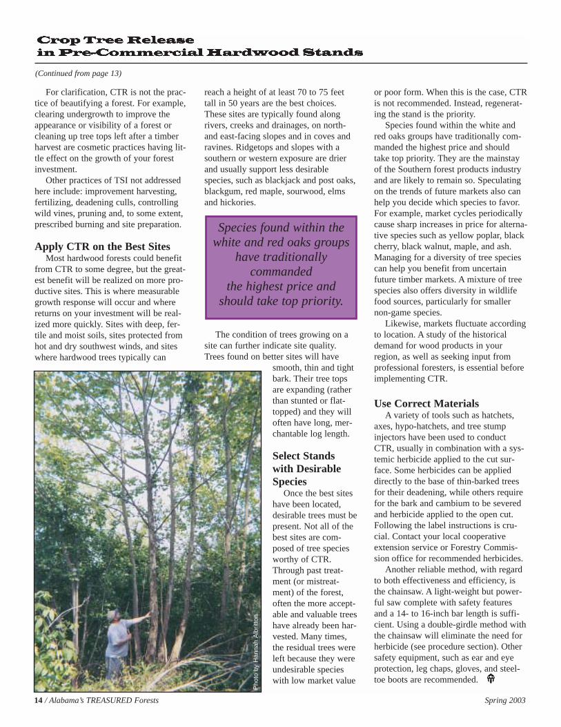
Species found within thewhite and red oaks groups
have traditionally commanded
the highest price andshould take top priority.
Pho
to b
y H
anna
h A
lbrit
ton
Spring 2003 Alabama’s TREASURED Forests / 15
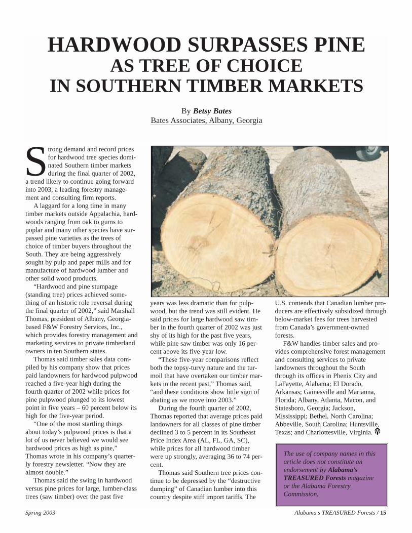
Strong demand and record pricesfor hardwood tree species domi-nated Southern timber marketsduring the final quarter of 2002,
a trend likely to continue going forwardinto 2003, a leading forestry manage-ment and consulting firm reports.
A laggard for a long time in manytimber markets outside Appalachia, hard-woods ranging from oak to gums topoplar and many other species have sur-passed pine varieties as the trees ofchoice of timber buyers throughout theSouth. They are being aggressivelysought by pulp and paper mills and formanufacture of hardwood lumber andother solid wood products.
“Hardwood and pine stumpage(standing tree) prices achieved some-thing of an historic role reversal duringthe final quarter of 2002,” said MarshallThomas, president of Albany, Georgia-based F&W Forestry Services, Inc.,which provides forestry management andmarketing services to private timberlandowners in ten Southern states.
Thomas said timber sales data com-piled by his company show that pricespaid landowners for hardwood pulpwoodreached a five-year high during thefourth quarter of 2002 while prices forpine pulpwood plunged to its lowestpoint in five years – 60 percent below itshigh for the five-year period.
“One of the most startling thingsabout today’s pulpwood prices is that alot of us never believed we would seehardwood prices as high as pine,”Thomas wrote in his company’s quarter-ly forestry newsletter. “Now they arealmost double.”
Thomas said the swing in hardwoodversus pine prices for large, lumber-classtrees (saw timber) over the past five
years was less dramatic than for pulp-wood, but the trend was still evident. Hesaid prices for large hardwood saw tim-ber in the fourth quarter of 2002 was justshy of its high for the past five years,while pine saw timber was only 16 per-cent above its five-year low.
“These five-year comparisons reflectboth the topsy-turvy nature and the tur-moil that have overtaken our timber mar-kets in the recent past,” Thomas said,“and these conditions show little sign ofabating as we move into 2003.”
During the fourth quarter of 2002,Thomas reported that average prices paidlandowners for all classes of pine timberdeclined 3 to 5 percent in its SoutheastPrice Index Area (AL, FL, GA, SC),while prices for all hardwood timberwere up strongly, averaging 36 to 74 per-cent.
Thomas said Southern tree prices con-tinue to be depressed by the “destructivedumping” of Canadian lumber into thiscountry despite stiff import tariffs. The
U.S. contends that Canadian lumber pro-ducers are effectively subsidized throughbelow-market fees for trees harvestedfrom Canada’s government-ownedforests.
F&W handles timber sales and pro-vides comprehensive forest managementand consulting services to privatelandowners throughout the Souththrough its offices in Phenix City andLaFayette, Alabama; El Dorado,Arkansas; Gainesville and Marianna,Florida; Albany, Atlanta, Macon, andStatesboro, Georgia; Jackson,Mississippi; Bethel, North Carolina;Abbeville, South Carolina; Huntsville,Texas; and Charlottesville, Virginia.
HARDWOOD SURPASSES PINE AS TREE OF CHOICE
IN SOUTHERN TIMBER MARKETSBy Betsy Bates
Bates Associates, Albany, Georgia
The use of company names in thisarticle does not constitute anendorsement by Alabama’s TREASURED Forests magazineor the Alabama ForestryCommission.
Southern Pine Beetles kill on theaverage $10 million worth oftimber each year in Alabama.This economical impact far
exceeds any other damaging agent in thestate, including wildfire. The control ofany Southern Pine Beetle infestationstarts with detection. You have to findthem before you can control them. TheAlabama Forestry Commission (AFC) ischarged by law to detect insect and dis-ease infestations, determine the landown-er, and contact the landowner with rec-ommended control measures. Since1997, the Alabama Forestry Commissionhas used a type of Global PositioningSystem (GPS) to record the location ofthe SPB infestations.
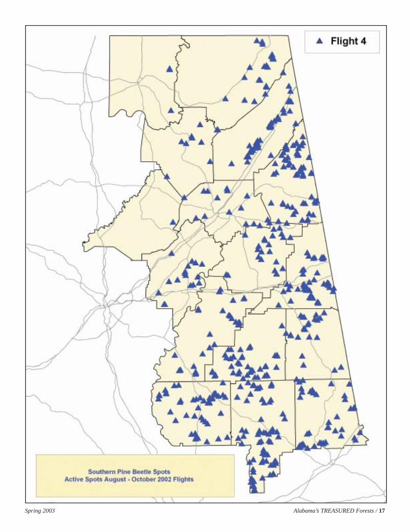
The GPS unit installed in the AFCaircraft communicates with satellitesorbiting the earth. By “locking on” toseveral satellites at one time the latitudeand longitude of the location can bedetermined and this information is storedin the GPS unit. The pilot and/orobservers scan the forest through win-dows of the aircraft for SPB infestationsand the pilot flies directly over the spotand records the location. Each county inAlabama is flown over (by region) four
times during a year. After a county flighthas been completed, the SPB infestationdata on the GPS is “downloaded” into acomputer. This data is then transferred toa contractor who has a GeographicInformation System (GIS) and the datafrom the GPS is displayed on a topo-graphic map. Any information from theairplane can be overlaid on a map andprinted out in any size. The ForestryCommission is presently using theSouthern Company GIS, based inBirmingham as its contractor. Hopefullyin the near future the ForestryCommission will have the GIS capabili-ties to print these maps without contract-ing this service.
The contractor is sent the GPS dataand it is converted into maps. They fur-nish a large county map and smallerindividual 8 X 11 maps of each infesta-tion. After the state has completed eachof the four flights, the contractor furnish-es a large state map of all counties withSPB infestations and web-based maps ofthe AFC regions. The county maps andtopographic maps with the SPB spotprominently centered on the page aresent to the County Forester. The CountyForester enters the SPB spot information
into a computer data management pro-gram where the spot can be tracked untilthe infestation is controlled. This systemallows the Forester to determine thenumber of active infestations in hiscounty and to work with landownerswho are having a problem getting theirspots controlled. After entering the SPBspot data a letter is generated to alllandowners who have active spotsencouraging them to control the infesta-tion as soon as possible. They are alsosent an information packet containingthe color map, control measures, andpotential timber buyers who do SPBcontrol work.
This GPS/computer mapping-basedsystem has not only increased detectionaccuracy and efficiency, increased thepercent of the spots controlled, andreduced man-hours expended, but it alsogives a professional product and has setthe standard for other states to follow inSPB detection efforts. If you as alandowner want to know more aboutSPB detection in your county, contactyour local county Alabama ForestryCommission office.
Using Global Positioning Systems
in Southern Pine Beetle
DetectionBy Jim Hyland
Forest Health Specialist, Alabama Forestry Commission
16 / Alabama’s TREASURED Forests Spring 2003
Finding Those Bugs:Finding Those Bugs:
Spring 2003 Alabama’s TREASURED Forests / 17

18 / Alabama’s TREASURED Forests Spring 2003
The role of the Alabama ForestryCommission (AFC) is to educateall participants in forestry opera-tions about the need to use Best
Management Practices (BMPs) forForestry to protect water quality. The useof BMPs is voluntary. However, weencourage their use to prevent the poten-tial for violating federal and state waterquality laws. BMPs have proven effectivein this effort. We also offer our technicalassistance to help prevent water qualitycomplaints involving forestry.
Enforcement of the Alabama WaterPollution Control Act is by monitoringand responding to complaints. In forestry,the monitoring is done on a formal, statis-tically sound basis by the AFC. When aproblem is discovered, the Commissionworks with the operator and landowner,following the same procedures as for acitizen complaint. When a citizen com-plaint about improper harvesting is filed,the Alabama Department of Environ-mental Management (ADEM) refers thecomplaint to the AFC for investigation.
Commission personnel will visit thesite and look for lack of compliance withthe BMPs and other obvious problems. Ifproblems are found, the AFC discussesthem with the logger, the supervisingforester, and the landowner, suggestingways to clean up the site and preventfuture problems. Recommendations mightinclude removal of tops and other debrisfrom the stream, stabilization of roads,disturbed stream banks, stream crossings,skid trails and/or landings, and proper dis-posal of trash. Usually a 30-day clean upperiod is granted, after which the site isreinspected. In nearly all cases the site is
acceptable after clean up and the case isclosed.
If the harvester and/or landownerrefuses to clean up the damage, the case isreferred to the State Forester’s office andthen to ADEM. ADEM has the legalauthority and responsibility to protectwater quality from either point or non-point sources of pollution. Violators maybe subject to civil penalties of up to$25,000 per day per violation unlesseffective actions are taken immediately tocorrect water quality impairment. Thesefines can be filed against all involved per-sons. Less than ten percent of BMP inves-tigations statewide end up being referredto ADEM.
Description of Specific AFC Tasks Related To Water Quality
The following tasks have been identi-fied by the Alabama Forestry Commissionand are essential elements of the manage-ment plan to achieve Non-Point Source(NPS) pollution control from silviculturalactivities.
1. Complaint InvestigationCounty AFC personnel will investigate
any BMP complaints filed by the publicor referred by ADEM or the SustainableForestry Initiative “hot-line.” (A summaryof the activities for Fiscal Year 2002 isfound in the accompanying table.)
Water Quality in Alabama: The Role of the
Alabama Forestry Commission
The 43 BMP complaints that the Alabama Forestry Commission responded tothis year represents the highest number of complaints received during anyprevious year.
BMP COMPLAINTS FOR 2002
Jim HylandForest Health Specialist,
Alabama Forestry Commission
By Tim AlbrittonCost Share Administrator,
Alabama Forestry Commissionand
Spring 2003 Alabama’s TREASURED Forests / 19
2. Basic MonitoringEach year the Commission performs
random aerial monitoring of loggingoperations over half of the state. (InFiscal Year 2002, a total of 213 randomlyselected harvest sites in the Southwestand Southeast Regions were aeriallyinspected. The northern regions will bemonitored in Fiscal Year 2003.)
Additionally, each county monitors sixharvesting operations each year, alsoselected at random, using the BMP moni-toring form.
3. Intensive MonitoringBMP monitoring activity will be in-
creased in the ten highest severance taxcounties to the level of eight harvestinspections per year, in addition to com-plaint investigations.
4. Cost Share ProgramsThere are several cost-sharing pro-
grams that assist landowners in develop-ing their forest. These include theForestry Incentives Program (FIP), theAlabama Agricultural & Conservation
Development Commission Program(AA&CDC), the Conservation ReserveProgram (CRP), and the StewardshipIncentives Program (SIP). These pro-grams refund the cost of forestry opera-tions that meet certain specifications. TheCommission provides technical assis-tance for these programs and includesBMP specifications in all operations onthe landowner’s property.
5. On-the-Ground, One-on-OneTraining
Commission personnel conduct thistraining in response to complaints andalso during inspections. If an operator ismisusing BMPs, it is easy to show himhis mistakes on the property and showhim how to improve future operations.This practice has proven effective in thepast.
6. TREASURE ForestThe TREASURE Forest program
encourages landowners, through publicrecognition, to manage their land in abalanced, ecologically-based manner
under a multiple-use system. Landownerstarget two specific land uses, while theywork to enhance the entire forest ecosys-tem. One mandatory requirement is theuse of BMPs in all forestry operations.
7. Publications & BookletsMagazine articles, booklets, pamphlets,
and presentations about Alabama’s BMPsare used in outreach and education.
SummaryOverall, the Commission data for
2002 indicated a BMP compliance rate ofabout 95 percent. This signifies that log-gers across Alabama are following BestManagement Practices for Forestry.
EPA Withdraws TMDL Rules – Finally!
The Environmental ProtectionAgency (EPA), on March 19, publishedthe withdrawal of the Total MaximumDaily Load (TMDL) regulations issuedby the Clinton administration inAugust 2000. The Clinton regulationswere controversial from the time theywere proposed in 1999. Almost simul-taneous with their issuance in 2000,Congress passed a law preventing theregulations from going into effect andordering various studies of their effec-tiveness. The TMDL program is abackstop measure by which states tar-get waters that remain polluted aftertechnological remedies have beenapplied to known sources. Various law-suits were filed challenging the 2000regulations, including one by theAmerican Forest & Paper Association.The EPA obtained a suspension of thelitigation through April 2003 to allowtime to further review the TMDL pro-gram, the 2000 regulations, and thestudies ordered by Congress. The EPAhas not decided whether to continuewith the pre-2000, reinstated regula-tions or to propose a new set of revi-sions. The agency had floated severalideas last year under the heading of a“watershed rule,” but has now madeclear that it has no schedule forproposing a new rule.
Reprinted from Forest Resources (3/21/03),a publication of the American Forest& Paper Association, Inc.
20 / Alabama’s TREASURED Forests Spring 2003
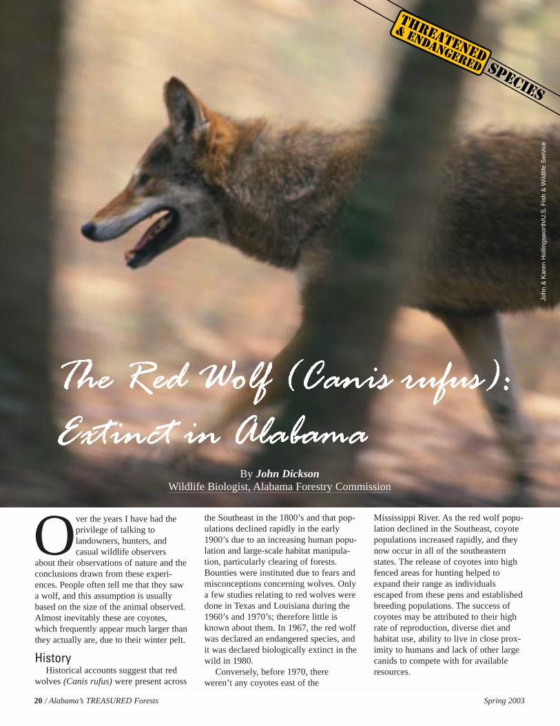
Over the years I have had theprivilege of talking tolandowners, hunters, andcasual wildlife observers
about their observations of nature and theconclusions drawn from these experi-ences. People often tell me that they sawa wolf, and this assumption is usuallybased on the size of the animal observed.Almost inevitably these are coyotes,which frequently appear much larger thanthey actually are, due to their winter pelt.
HistoryHistorical accounts suggest that red
wolves (Canis rufus) were present across
the Southeast in the 1800’s and that pop-ulations declined rapidly in the early1900’s due to an increasing human popu-lation and large-scale habitat manipula-tion, particularly clearing of forests.Bounties were instituted due to fears andmisconceptions concerning wolves. Onlya few studies relating to red wolves weredone in Texas and Louisiana during the1960’s and 1970’s; therefore little isknown about them. In 1967, the red wolfwas declared an endangered species, andit was declared biologically extinct in thewild in 1980.
Conversely, before 1970, thereweren’t any coyotes east of the
Mississippi River. As the red wolf popu-lation declined in the Southeast, coyotepopulations increased rapidly, and theynow occur in all of the southeasternstates. The release of coyotes into highfenced areas for hunting helped toexpand their range as individualsescaped from these pens and establishedbreeding populations. The success ofcoyotes may be attributed to their highrate of reproduction, diverse diet andhabitat use, ability to live in close prox-imity to humans and lack of other largecanids to compete with for availableresources.
By John DicksonWildlife Biologist, Alabama Forestry Commission
John
&K
aren
Hol
lings
wor
th/U
.S.F
ish
&W
ildlif
e S
ervi
ce
Spring 2003 Alabama’s TREASURED Forests / 21
Restoration AttemptsRestoring large carnivores such as
bears, mountain lions, or wolves is a dif-ficult undertaking at best. These typespecies have home ranges that may coverthousands of acres, which usually limitsrestoration efforts to military bases,national forests, or national wildliferefuges. Areas such as these are amongthe only remaining large habitats with
minimal disturbance from humans andfew bisecting roads. Public opposition torestoration attempts can be fierce due toconcerns about livestock predation ormisconceptions regarding interactionswith humans.
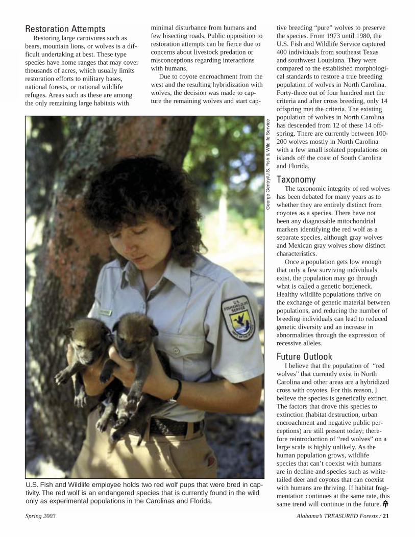
Due to coyote encroachment from thewest and the resulting hybridization withwolves, the decision was made to cap-ture the remaining wolves and start cap-
tive breeding “pure” wolves to preservethe species. From 1973 until 1980, theU.S. Fish and Wildlife Service captured400 individuals from southeast Texasand southwest Louisiana. They werecompared to the established morphologi-cal standards to restore a true breedingpopulation of wolves in North Carolina.Forty-three out of four hundred met thecriteria and after cross breeding, only 14offspring met the criteria. The existingpopulation of wolves in North Carolinahas descended from 12 of these 14 off-spring. There are currently between 100-200 wolves mostly in North Carolinawith a few small isolated populations onislands off the coast of South Carolinaand Florida.
TaxonomyThe taxonomic integrity of red wolves
has been debated for many years as towhether they are entirely distinct fromcoyotes as a species. There have notbeen any diagnosable mitochondrialmarkers identifying the red wolf as aseparate species, although gray wolvesand Mexican gray wolves show distinctcharacteristics.
Once a population gets low enoughthat only a few surviving individualsexist, the population may go throughwhat is called a genetic bottleneck.Healthy wildlife populations thrive onthe exchange of genetic material betweenpopulations, and reducing the number ofbreeding individuals can lead to reducedgenetic diversity and an increase inabnormalities through the expression ofrecessive alleles.
Future OutlookI believe that the population of “red
wolves” that currently exist in NorthCarolina and other areas are a hybridizedcross with coyotes. For this reason, Ibelieve the species is genetically extinct.The factors that drove this species toextinction (habitat destruction, urbanencroachment and negative public per-ceptions) are still present today; there-fore reintroduction of “red wolves” on alarge scale is highly unlikely. As thehuman population grows, wildlifespecies that can’t coexist with humansare in decline and species such as white-tailed deer and coyotes that can coexistwith humans are thriving. If habitat frag-mentation continues at the same rate, thissame trend will continue in the future.
U.S. Fish and Wildlife employee holds two red wolf pups that were bred in cap-tivity. The red wolf is an endangered species that is currently found in the wildonly as experimental populations in the Carolinas and Florida.
Geo
rge
Gen
try/
U.S
.Fis
h &
Wild
life
Ser
vice
22 / Alabama’s TREASURED Forests Spring 2003
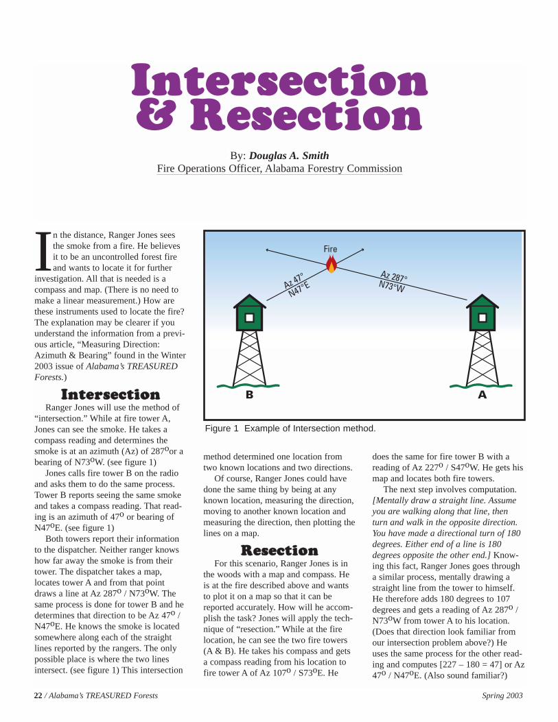
In the distance, Ranger Jones seesthe smoke from a fire. He believesit to be an uncontrolled forest fireand wants to locate it for further
investigation. All that is needed is acompass and map. (There is no need tomake a linear measurement.) How arethese instruments used to locate the fire?The explanation may be clearer if youunderstand the information from a previ-ous article, “Measuring Direction:Azimuth & Bearing” found in the Winter2003 issue of Alabama’s TREASUREDForests.)
IInntteerrsseeccttiioonnRanger Jones will use the method of
“intersection.” While at fire tower A,Jones can see the smoke. He takes acompass reading and determines thesmoke is at an azimuth (Az) of 287oor abearing of N73oW. (see figure 1)
Jones calls fire tower B on the radioand asks them to do the same process.Tower B reports seeing the same smokeand takes a compass reading. That read-ing is an azimuth of 47o or bearing ofN47oE. (see figure 1)
Both towers report their informationto the dispatcher. Neither ranger knowshow far away the smoke is from theirtower. The dispatcher takes a map,locates tower A and from that pointdraws a line at Az 287o / N73oW. Thesame process is done for tower B and hedetermines that direction to be Az 47o /N47oE. He knows the smoke is locatedsomewhere along each of the straightlines reported by the rangers. The onlypossible place is where the two linesintersect. (see figure 1) This intersection
method determined one location fromtwo known locations and two directions.
Of course, Ranger Jones could havedone the same thing by being at anyknown location, measuring the direction,moving to another known location andmeasuring the direction, then plotting thelines on a map.
RReesseeccttiioonnFor this scenario, Ranger Jones is in
the woods with a map and compass. Heis at the fire described above and wantsto plot it on a map so that it can bereported accurately. How will he accom-plish the task? Jones will apply the tech-nique of “resection.” While at the firelocation, he can see the two fire towers(A & B). He takes his compass and getsa compass reading from his location tofire tower A of Az 107o / S73oE. He
does the same for fire tower B with areading of Az 227o / S47oW. He gets hismap and locates both fire towers.
The next step involves computation.[Mentally draw a straight line. Assumeyou are walking along that line, thenturn and walk in the opposite direction.You have made a directional turn of 180degrees. Either end of a line is 180degrees opposite the other end.] Know-ing this fact, Ranger Jones goes througha similar process, mentally drawing astraight line from the tower to himself.He therefore adds 180 degrees to 107degrees and gets a reading of Az 287o /N73oW from tower A to his location.(Does that direction look familiar fromour intersection problem above?) Heuses the same process for the other read-ing and computes [227 – 180 = 47] or Az47o / N47oE. (Also sound familiar?)
B A
Az 47°
N47°EAz 287°N73°W
Fire
Figure 1 Example of Intersection method.
IInntteerrsseeccttiioonn && RReesseeccttiioonn
By: Douglas A. SmithFire Operations Officer, Alabama Forestry Commission
Spring 2003 Alabama’s TREASURED Forests / 23
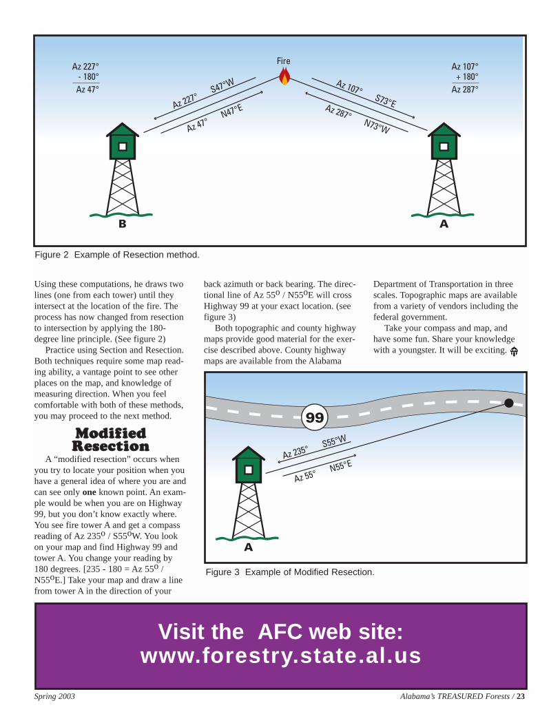
Using these computations, he draws twolines (one from each tower) until theyintersect at the location of the fire. Theprocess has now changed from resectionto intersection by applying the 180-degree line principle. (See figure 2)
Practice using Section and Resection.Both techniques require some map read-ing ability, a vantage point to see otherplaces on the map, and knowledge ofmeasuring direction. When you feelcomfortable with both of these methods,you may proceed to the next method.
MMooddiiffiieeddRReesseeccttiioonn
A “modified resection” occurs whenyou try to locate your position when youhave a general idea of where you are andcan see only one known point. An exam-ple would be when you are on Highway99, but you don’t know exactly where.You see fire tower A and get a compassreading of Az 235o / S55oW. You lookon your map and find Highway 99 andtower A. You change your reading by180 degrees. [235 - 180 = Az 55o /N55oE.] Take your map and draw a linefrom tower A in the direction of your
back azimuth or back bearing. The direc-tional line of Az 55o / N55oE will crossHighway 99 at your exact location. (seefigure 3)
Both topographic and county highwaymaps provide good material for the exer-cise described above. County highwaymaps are available from the Alabama
Department of Transportation in threescales. Topographic maps are availablefrom a variety of vendors including thefederal government.
Take your compass and map, andhave some fun. Share your knowledgewith a youngster. It will be exciting.
B A
Fire
Az 227° S47°W
Az 47° N47°E
Az 107° S73°EAz 287° N73°W
Az 227°- 180°
Az 47°
Az 107°+ 180°
Az 287°
Figure 2 Example of Resection method.
Visit the AFC web site:www.forestry.state.al.us
A
99
Az 235° S55°W
Az 55° N55°E
Figure 3 Example of Modified Resection.
24 / Alabama’s TREASURED Forests Spring 2003
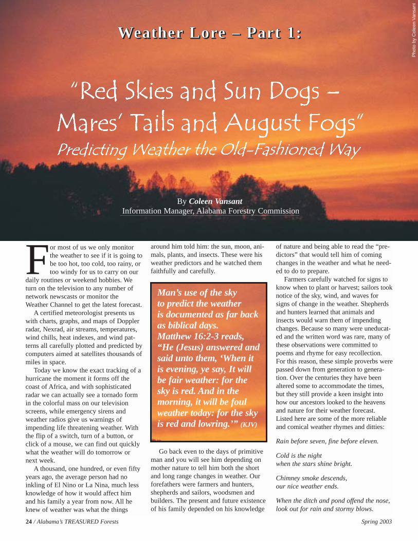
For most of us we only monitorthe weather to see if it is going tobe too hot, too cold, too rainy, ortoo windy for us to carry on our
daily routines or weekend hobbies. Weturn on the television to any number ofnetwork newscasts or monitor theWeather Channel to get the latest forecast.
A certified meteorologist presents uswith charts, graphs, and maps of Dopplerradar, Nexrad, air streams, temperatures,wind chills, heat indexes, and wind pat-terns all carefully plotted and predicted bycomputers aimed at satellites thousands ofmiles in space.
Today we know the exact tracking of ahurricane the moment it forms off thecoast of Africa, and with sophisticatedradar we can actually see a tornado formin the colorful mass on our televisionscreens, while emergency sirens andweather radios give us warnings ofimpending life threatening weather. Withthe flip of a switch, turn of a button, orclick of a mouse, we can find out quicklywhat the weather will do tomorrow ornext week.
A thousand, one hundred, or even fiftyyears ago, the average person had noinkling of El Nino or La Nina, much lessknowledge of how it would affect himand his family a year from now. All heknew of weather was what the things
around him told him: the sun, moon, ani-mals, plants, and insects. These were hisweather predictors and he watched themfaithfully and carefully.
Go back even to the days of primitiveman and you will see him depending onmother nature to tell him both the shortand long range changes in weather. Ourforefathers were farmers and hunters,shepherds and sailors, woodsmen andbuilders. The present and future existenceof his family depended on his knowledge
of nature and being able to read the “pre-dictors” that would tell him of comingchanges in the weather and what he need-ed to do to prepare.
Farmers carefully watched for signs toknow when to plant or harvest; sailors tooknotice of the sky, wind, and waves forsigns of change in the weather. Shepherdsand hunters learned that animals andinsects would warn them of impendingchanges. Because so many were uneducat-ed and the written word was rare, many ofthese observations were committed topoems and rhyme for easy recollection.For this reason, these simple proverbs werepassed down from generation to genera-tion. Over the centuries they have beenaltered some to accommodate the times,but they still provide a keen insight intohow our ancestors looked to the heavensand nature for their weather forecast.Listed here are some of the more reliableand comical weather rhymes and ditties:
Rain before seven, fine before eleven.
Cold is the night when the stars shine bright.
Chimney smoke descends,our nice weather ends.
When the ditch and pond offend the nose,look out for rain and stormy blows.
WWWWeeeeaaaatttthhhheeeerrrr LLLLoooorrrreeee –––– PPPPaaaarrrrtttt 1111::::
By Coleen VansantInformation Manager, Alabama Forestry Commission
Pho
to b
y C
olee
n V
ansa
nt
Man’s use of the sky to predict the weather is documented as far backas biblical days. Matthew 16:2-3 reads, “He (Jesus) answered andsaid unto them, ‘When itis evening, ye say, It willbe fair weather: for thesky is red. And in themorning, it will be foulweather today: for the skyis red and lowring.’” (KJV)
Spring 2003 Alabama’s TREASURED Forests / 25
When clouds look like black smoke,a wise man will put on his cloak.
A rainbow in the morning is the shepherd’s warning. A rainbow at night is the shepherd’s delight.
Catchy drawer and sticky door,Coming rain will pour and pour.
When the wind blows from the west,fish bite best. When it blows from the east,fish bite the least.
Red sky at night, sailors’ delight;Red sky in morning, sailors take warning.
Rain then the wind, pick up and go in.
If salt pork turns sour,then be ready for a shower.
When a cow bellows three times withoutstopping, rain will come a hopping.
If a cold August follows a hot July,It foretells a winter hard and dry.
If there’s thunder during Christmas week,the winter will be anything but meek.
If it thunders on All Fool’s Day,It brings good crops of corn and hay.
The moon and the weather may changetogether, but a change of the moon will not change the weather.
Sea gull, sea gull, sit on the sand, It’s nevergood weather while you’re on the land.
Because it was so vast and obvious, oneof the main weather indicators was theheavens and all of its bodies. The sun,moon, stars, sky, clouds and even rainbowswere all depended on to give signs of whatwas to come. For instance, for sailors a bluesky in the northwest foretells fair weatherand a good breeze. A Zuni Indian saying is,“If the moon’s face is red, of water shespeaks.” One old proverb is that a rainbowin the morning indicates approaching rain; arainbow at sunset tells that rain is leavingand fair weather is on the way. More weath-er lores pertaining to the sky and celestialbodies are listed below.
A ring around the sun or moon,means rain or snow coming soon.
If you look at the sun in the middle of theday and there is a white halo (a Sun Dog)around it, there will be a drastic changein the weather within 12-24 hours.
A red sun at dusk (not a red sky)tells of dry weather.
Mares’ tails (cirrus clouds) and mackerel scales (altocumulus clouds)make tall ships carry low sails.
Evening red and morning gray,sends the traveler on his way. Evening gray and morning red,brings the rain down on his head.
When small clouds join and thicken,expect rain.
The sky turns green in a storm when there is hail.
A veering wind will clear the sky,A backing wind says storms are nigh.
A round-topped cloud and flattened base,carries rainfall in its face.
When the wind is from the south the rain is in its mouth.
Clear moon, frost soon.
The east wind brings aches and pains.
A falling meteor predicts fair weather.
If rain falls while the sun shines,then the shower will last half an hour.
Of all the seasons, earlier man appearsto have been more worried about whatwinter would bring. Making preparationsfor himself, his family, and animals to sur-vive what could be a long harsh winterwas of vital importance. He was dependenton signs of nature to tell him what toexpect during the winter months. There arefar more proverbs and lores dealing withOld Man Winter than any other season. Forinstance, for every fog in August, therewill be a snowfall in winter. When youhear the first cicada of the summer, expectthe first frost of the year in exactly 90days. Listed below are more sayings deal-ing with predicting the oncoming winter.
Two frosts and lots of rain mean coldweather is near.
A late frost means a bad winter.
At least three severe fogs in June or Julymean early snow.
Lots of low rolling thunder in the late fallmeans a bad winter.
A long hot summer means a long coldwinter.
It will be a hard winter if smoke from thechimney flows toward or settles on theground.
If it’s cloudy and smoke rises, expect snow.
The number of days old the moon isat the first snow, tells how many snows
there will be that winter.
Burning wood pops before rain or snow.
The closer the new moon to ChristmasDay, the harder the winter.
A warm November is the sign of a badwinter.
Thunder in the fall foretells a cold winter.
(Continued on page 26)
Pho
to b
y C
olee
n V
ansa
nt
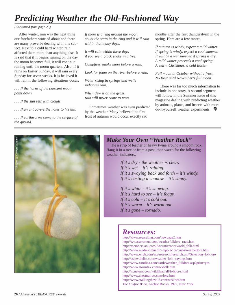
Make Your Own “Weather Rock”Tie a strip of leather or heavy twine around a smooth rock.
Hang it in a tree or from a post, then watch for the followingweather indicators.
If it’s dry - the weather is clear.If it’s wet – it’s raining.If it’s swaying back and forth – it’s windy.If it’s casting a shadow – it’s sunny.
If it’s white - it’s snowing.If it’s hard to see – it’s foggy.If it’s cold – it’s cold out.If it’s warm – it’s warm out.If it’s gone – tornado.
26 / Alabama’s TREASURED Forests Spring 2003
After winter, rain was the next thingour forefathers worried about and thereare many proverbs dealing with this sub-ject. Next to a cold hard winter, rainaffected them more than anything else. Itis said that if it begins raining on the daythe moon becomes full, it will continueraining until the moon quarters. Also, if itrains on Easter Sunday, it will rain everySunday for seven weeks. It is believed itwill rain if the following situations occur:
. . . If the horns of the crescent moonpoint down.
. . . If the sun sets with clouds.
. . . If an ant covers the holes to his hill.
. . . If earthworms come to the surface ofthe ground.
If there is a ring around the moon,count the stars in the ring and it will rainwithin that many days.
It will rain within three days if you see a black snake in a tree.
Campfires smoke more before a rain.
Look for foam on the river before a rain.
Water rising in springs and wells indicates rain.
When dew is on the grass,rain will never come to pass.
Sometimes weather was even predictedby the weather. Many believed the firstfrost of autumn would occur exactly six
months after the first thunderstorm in thespring. Here are a few more:
If autumn is windy, expect a mild winter. If spring is windy, expect a cool summer. It will be a wet summer if spring is dry. A mild winter preceeds a cool spring. A warm Christmas, a cold Easter.
Full moon in October without a frost,No frost until November’s full moon.
There was far too much information toinclude in one story. A second segmentwill follow in the Summer issue of thismagazine dealing with predicting weatherby animals, plants, and insects with moredo-it-yourself weather experiments.
Predicting Weather the Old-Fashioned Way(Continued from page 25)
Resources:http://www.reearthing.com/newpage2.htmhttp://wv.essortment.com/weatherfolklore_ruao.htmhttp://members.aol.com/Accustiver/wxworld_folk.htmlhttp://www.meds-sdmm.dfo-mpo.gc.ca/cmos/weatherlore.htmlhttp://www.wrgb.com/wx/research/research.asp?Selection=folklorehttp://ashevillelist.com/weather_folk_sayings.htmhttp://www.carolina.com/earth/weather_folklore.asp?print=yeshttp://www.stormfax.com/wxfolk.htmhttp://ncnatural.com/wildflwr/fall/folklore.htmlhttp://www.chestnut-sw.com/lore.htmhttp://www.stalkingthewild.com/weather.htmThe Foxfire Book, Anchor Books, 1972, New York
Pho
to b
y C
olee
n V
ansa
nt
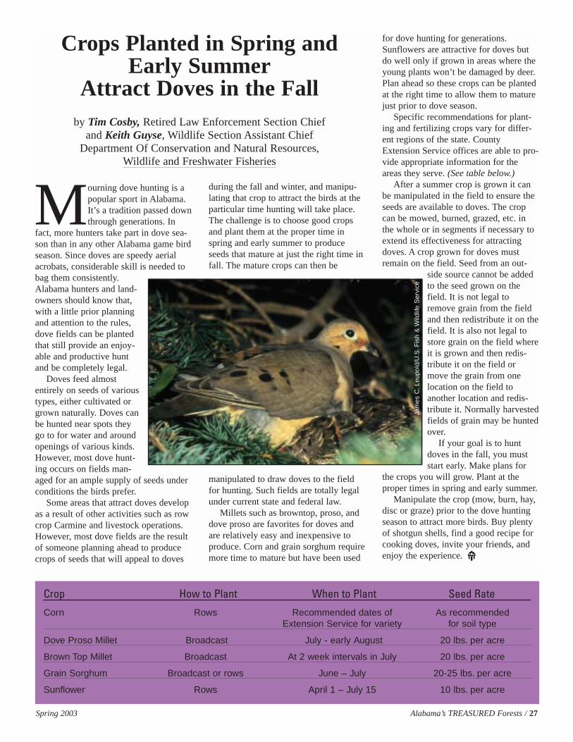
Spring 2003 Alabama’s TREASURED Forests / 27
Mourning dove hunting is apopular sport in Alabama.It’s a tradition passed downthrough generations. In
fact, more hunters take part in dove sea-son than in any other Alabama game birdseason. Since doves are speedy aerialacrobats, considerable skill is needed tobag them consistently.Alabama hunters and land-owners should know that,with a little prior planningand attention to the rules,dove fields can be plantedthat still provide an enjoy-able and productive huntand be completely legal.
Doves feed almostentirely on seeds of varioustypes, either cultivated orgrown naturally. Doves canbe hunted near spots theygo to for water and aroundopenings of various kinds.However, most dove hunt-ing occurs on fields man-aged for an ample supply of seeds underconditions the birds prefer.
Some areas that attract doves developas a result of other activities such as rowcrop Carmine and livestock operations.However, most dove fields are the resultof someone planning ahead to producecrops of seeds that will appeal to doves
during the fall and winter, and manipu-lating that crop to attract the birds at theparticular time hunting will take place.The challenge is to choose good cropsand plant them at the proper time inspring and early summer to produceseeds that mature at just the right time infall. The mature crops can then be
manipulated to draw doves to the fieldfor hunting. Such fields are totally legalunder current state and federal law.
Millets such as browntop, proso, anddove proso are favorites for doves andare relatively easy and inexpensive toproduce. Corn and grain sorghum requiremore time to mature but have been used
for dove hunting for generations.Sunflowers are attractive for doves butdo well only if grown in areas where theyoung plants won’t be damaged by deer.Plan ahead so these crops can be plantedat the right time to allow them to maturejust prior to dove season.
Specific recommendations for plant-ing and fertilizing crops vary for differ-ent regions of the state. CountyExtension Service offices are able to pro-vide appropriate information for theareas they serve. (See table below.)
After a summer crop is grown it canbe manipulated in the field to ensure theseeds are available to doves. The cropcan be mowed, burned, grazed, etc. inthe whole or in segments if necessary toextend its effectiveness for attractingdoves. A crop grown for doves mustremain on the field. Seed from an out-
side source cannot be addedto the seed grown on thefield. It is not legal toremove grain from the fieldand then redistribute it on thefield. It is also not legal tostore grain on the field whereit is grown and then redis-tribute it on the field ormove the grain from onelocation on the field toanother location and redis-tribute it. Normally harvestedfields of grain may be huntedover.
If your goal is to huntdoves in the fall, you muststart early. Make plans for
the crops you will grow. Plant at theproper times in spring and early summer.
Manipulate the crop (mow, burn, hay,disc or graze) prior to the dove huntingseason to attract more birds. Buy plentyof shotgun shells, find a good recipe forcooking doves, invite your friends, andenjoy the experience.
Crop How to Plant When to Plant Seed Rate
Corn Rows Recommended dates of As recommendedExtension Service for variety for soil type
Dove Proso Millet Broadcast July - early August 20 lbs. per acre
Brown Top Millet Broadcast At 2 week intervals in July 20 lbs. per acre
Grain Sorghum Broadcast or rows June – July 20-25 lbs. per acre
Sunflower Rows April 1 – July 15 10 lbs. per acre
Crops Planted in Spring andEarly Summer
Attract Doves in the Fallby Tim Cosby, Retired Law Enforcement Section Chief
and Keith Guyse, Wildlife Section Assistant Chief Department Of Conservation and Natural Resources,
Wildlife and Freshwater Fisheries
Jam
es C
.Leu
pold
/U.S
.Fis
h &
Wild
life
Ser
vice
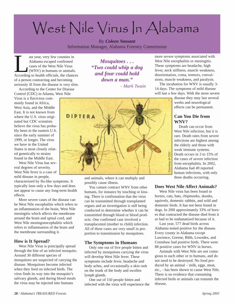
Last year, very few counties inAlabama escaped confirmedcases of the West Nile Virus(WNV) in humans or animals.
According to health officials, the chancesof a person contracting and becomingseriously ill from the disease is very slim.
According to the Center for DiseaseControl (CDC) in Atlanta, West NileVirus is a flavivirus com-monly found in Africa,West Asia, and the MiddleEast. It is not known fromwhere the U.S. virus origi-nated but CDC scientistsbelieve the virus has proba-bly been in the eastern U.S.since the early summer of1999, or longer. The viruswe have in the UnitedStates is most closely relat-ed genetically to strainsfound in the Middle East.
West Nile Virus has sev-eral degrees of severity.West Nile fever is a case ofmild disease in people,characterized by flu-like symptoms. Ittypically lasts only a few days and doesnot appear to cause any long-term healtheffects.
More severe cases of the disease canbe West Nile encephalitis which refers toan inflammation of the brain, West Nilemeningitis which affects the membranearound the brain and spinal cord, andWest Nile meningoencephalitis whichrefers to inflammation of the brain andthe membrane surrounding it.
How is It Spread?West Nile Virus is principally spread
through the bite of an infected mosquito.Around 30 different species ofmosquitoes are suspected of carrying thedisease. Mosquitoes become infectedwhen they feed on infected birds. Thevirus finds its way into the mosquito’ssalivary glands, and during blood mealsthe virus may be injected into humans
and animals, where it can multiply andpossibly cause illness.
You cannot contract WNV from otherhumans, for instance by touching or kiss-ing. There is confirmation that the viruscan be transmitted through transplantedorgans and an investigation is still beingconducted to determine whether it can betransmitted through blood or blood prod-ucts. One confirmed case involved atransplacental (mother to child) infection.All of these cases are very small in pro-portion to transmission by mosquitoes.
The Symptoms in HumansOnly one out of five people bitten and
infected by mosquitoes carrying the viruswill develop West Nile fever. Thesesymptoms include fever, headache andbody aches, and occasionally a skin rashon the trunk of the body and swollenlymph glands.
One out of 150 people bitten andinfected with the virus will experience the
more severe symptoms associated withWest Nile encephalitis or meningitis.These symptoms are headache, highfever, neck stiffness, muscle weakness,disorientation, coma, tremors, convul-sions, muscle weakness, and paralysis.
The incubation for WNV is usually 3-14 days. The symptoms of mild diseasewill last a few days. With the more severe
disease they may last severalweeks and neurologicaleffects can be permanent.
Can You Die fromWNV?
Death can occur fromWest Nile infection, but it israre. Death rates from severeinfections are highest amongthe elderly and those withweak immune systems.Death occurs in 3 to 15% ofthe cases of severe infectionfrom encephalitis. In 2002,Alabama had 49 reportedhuman infections, with onlythree deaths occurring.
Does West Nile Affect Animals?West Nile virus has been found in
horses, cats, bats, chipmunks, skunks,squirrels, domestic rabbits, and wild anddomestic birds. It has not been found indogs. In 200l approximately 33% of hors-es that contracted the disease died from itor had to be euthanatized because of it.
Last year, 577 dead birds acrossAlabama tested positive for the disease.Every county in Alabama exceptLawrence, Greene, Bibb, Lowndes, andCrenshaw had positive birds. There were88 positive cases for WNV in horses.
Animals with West Nile are not conta-gious to each other or to humans, and donot need to be destroyed. No food pro-duced by an animal – milk, eggs, meat,etc., - has been shown to cause West Nile.There is no evidence that consuminginfected birds or animals can transmit thedisease.
28 / Alabama’s TREASURED Forests Spring 2003
By Coleen VansantInformation Manager, Alabama Forestry Commission
Mosquitoes . . .“Two could whip a dog
and four could hold down a man.”
- Mark Twain
Cou
rtes
y of
CD
C
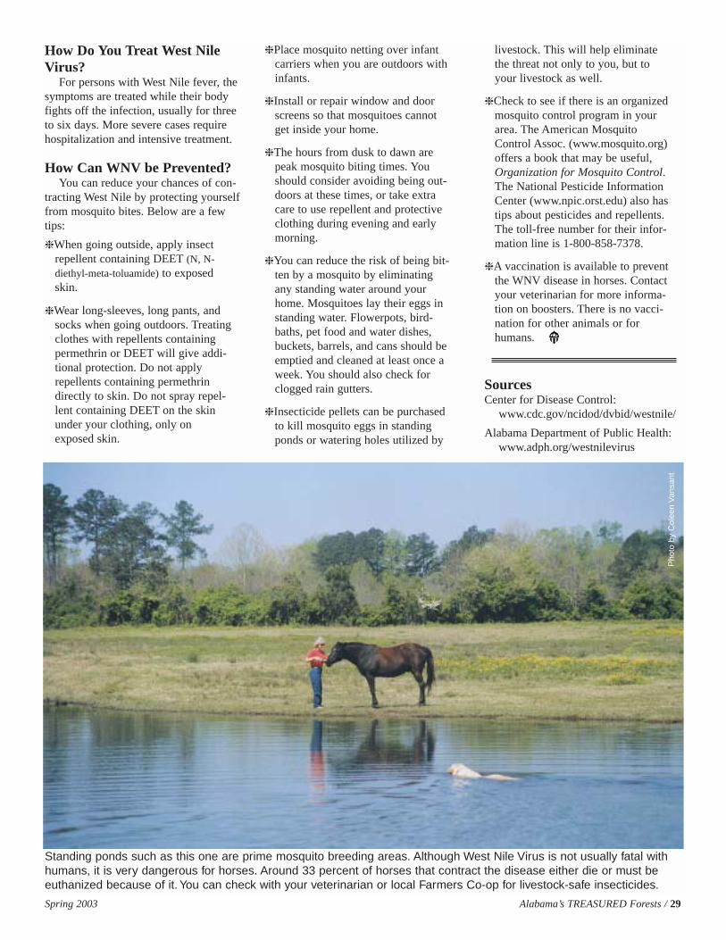
How Do You Treat West NileVirus?
For persons with West Nile fever, thesymptoms are treated while their bodyfights off the infection, usually for threeto six days. More severe cases requirehospitalization and intensive treatment.
How Can WNV be Prevented?You can reduce your chances of con-
tracting West Nile by protecting yourselffrom mosquito bites. Below are a fewtips:
❈ When going outside, apply insectrepellent containing DEET (N, N-diethyl-meta-toluamide) to exposedskin.
❈ Wear long-sleeves, long pants, andsocks when going outdoors. Treatingclothes with repellents containingpermethrin or DEET will give addi-tional protection. Do not applyrepellents containing permethrindirectly to skin. Do not spray repel-lent containing DEET on the skinunder your clothing, only onexposed skin.
❈ Place mosquito netting over infant carriers when you are outdoors withinfants.
❈ Install or repair window and doorscreens so that mosquitoes cannotget inside your home.
❈ The hours from dusk to dawn arepeak mosquito biting times. Youshould consider avoiding being out-doors at these times, or take extracare to use repellent and protectiveclothing during evening and earlymorning.
❈ You can reduce the risk of being bit-ten by a mosquito by eliminatingany standing water around yourhome. Mosquitoes lay their eggs instanding water. Flowerpots, bird-baths, pet food and water dishes,buckets, barrels, and cans should beemptied and cleaned at least once aweek. You should also check forclogged rain gutters.
❈ Insecticide pellets can be purchasedto kill mosquito eggs in standingponds or watering holes utilized by
livestock. This will help eliminatethe threat not only to you, but toyour livestock as well.
❈ Check to see if there is an organizedmosquito control program in yourarea. The American MosquitoControl Assoc. (www.mosquito.org)offers a book that may be useful,Organization for Mosquito Control.The National Pesticide InformationCenter (www.npic.orst.edu) also hastips about pesticides and repellents.The toll-free number for their infor-mation line is 1-800-858-7378.
❈ A vaccination is available to preventthe WNV disease in horses. Contactyour veterinarian for more informa-tion on boosters. There is no vacci-nation for other animals or forhumans.
SourcesCenter for Disease Control:
www.cdc.gov/ncidod/dvbid/westnile/
Alabama Department of Public Health:www.adph.org/westnilevirus
Spring 2003 Alabama’s TREASURED Forests / 29
Standing ponds such as this one are prime mosquito breeding areas. Although West Nile Virus is not usually fatal withhumans, it is very dangerous for horses. Around 33 percent of horses that contract the disease either die or must beeuthanized because of it. You can check with your veterinarian or local Farmers Co-op for livestock-safe insecticides.
Pho
to b
y C
olee
n V
ansa
nt
30 / Alabama’s TREASURED Forests Spring 2003
In a previous issue of Alabama’sTREASURED Forests magazine, thecommitment of the AlabamaForestry Commission (AFC) to the
underserved forest landowners ofAlabama was explained, and the necessi-ty and basis for an Outreach programwas established. At that time, fourOutreach Foresters had been hired - onefor each of the agency’s regions - towork with the underserved forestlandowners of the state. However, toenhance the efforts of these OutreachForesters and to succeed exponentially,other “key players” needed to beinvolved in the program.
In the early part of 2001, StateForester Timothy C. Boyce established anOutreach Advisory Council to assist withthe Commission’s outreach efforts. Thecouncil consists of two underserved for-est landowners from each region and twoothers at large that have demonstrated acommitment to sustainable forestry andan interest in community involvement. Inaddition there are also representativesfrom Tuskegee University, AlabamaA&M University, Auburn University, theUSDA Forest Service, the US Corps ofEngineers, the Federation of SouthernCooperatives, and the Alabama ForestryCommission. The collaboration of such adiverse group can better achieve the com-mon goal of outreach efforts.
To prioritize all of the ideas and activ-ities, the Outreach Advisory Councilidentified three objectives. The first is tocreate an atmosphere of trust betweenthe AFC and the underserved forestlandowners. To accomplish this particu-lar goal, the council will establish oppor-tunities for the landowners and theCommission to communicate in a com-fortable, timely, and consistent manner.Second, the council will assist the AFCin reaching out to these landowners byproviding feedback to the Commissionabout the true effectiveness and priorityareas of the program. The third objectiveis that the council will stimulate interest
and encourage participation of the under-served forest landowners in sustainableforest management practices by convey-ing to them the AFC’s interest, under-standing, and commitment to their landmanagement needs.
At the council’s initial meeting atTuskegee University, it was decided thatthere would be at least four meetings ayear - one in each region of Alabama, ata location identified by the council mem-
bers from that region. These meetingswill be structured, but informal, with twosessions. Once the location has beenchosen, the council will develop guide-lines for its organization and activities.The council will encourage landownersto talk about the Alabama ForestryCommission’s outreach efforts in theirregions by identifying successes andareas in need of improvement. The coun-cil will also obtain information on theCommission’s state and regional activi-ties and strategic plan. The council willencourage feedback and advice aboutsuch activities from the underserved for-est landowners. Finally, the council will
consider issues of recruitment and reten-tion of minority employees in the AFC.
The meetings are well planned andusually coordinated around a forestry-related event such as the TuskegeeFarmer’s Conference or the Federationof Southern Cooperatives’ AnnualMeeting. One particularly successfulmeeting was held at Auburn University’sHotel and Conference Center. It wasstrategically scheduled right before theAnnual TREASURE Forest Landowner’sConference to encourage the councilmembers to also attend the conference.At this Advisory Council Meeting, sever-al invited guests gave presentationsabout their outreach efforts in the under-served communities of Alabama. TheAFC’s Assistant State Forester explainedthe Forestry Commission’s strategic planand each AFC Regional Foresterexplained the status of outreach accom-plishments in his region. Additionally,the AFC Assistant Regional Foresters ofPrograms explained future plans forOutreach.
Another meeting was held at theSolon Dixon Center near Andalusia,Alabama. Important issues were dis-cussed such as the progress of AlabamaA&M University’s Silvopasture Project,the stage of the Alabama ForestryCommission’s Outreach Report, thedevelopment of an accurate minoritylandowners list, and the establishment ofthe new Forest LandownersEnhancement Program (FLEP).
Now, two years after the establish-ment of the Outreach Advisory Council,there is a general feeling that the meet-ings have been very successful. Many ofthe council members attend regularly andgive positive feedback about the Com-mission’s outreach efforts. The membersare enthusiastically interested in partici-pating and accomplishing the objectivesof the Outreach program.
Landowner Gwinn R. Ezell of HaleCounty measures diameter of pinetree.
The Outreach Advisory Council: Another Step Towards Outreach Success
By Dana McReynoldsOutreach Forester, Alabama Forestry Commission

Spring 2003 Alabama’s TREASURED Forests / 31
CHANGECHANGE OFOF ADDRESSADDRESS FORMFORMAre you receiving Alabama’s TREASURED Forests at the correct address?If not, please complete this form and return to:
Alabama's TREASURED Forests MagazineP.O. Box 302550 Montgomery, AL 36130-2550
New Address
Name: ______________________________________________
Address ______________________________________________
City:________________________ State:______ Zip:___________
Old Address as it appears on mailing label
Name: ______________________________________________
Address: ____________________________________________
City:________________________ State:______ Zip:___________
� Please check here if receiving duplicate copies and enclose both mailing labels.E-mail changes of address to: [email protected]
Outdoor Alabama Photo ContestOutdoor Alabama is pleased to announce its premier photo contest, with winning entries to be published in the February
2004 issue. The contest is open to any photographer except employees of the Alabama Department of Conservation andNatural Resources (ADCNR) and members of their immediate families. Previously published images are not eligible.
All photos must be taken in Alabama and species must be native to the state. The contest is limited to 35mm slides orlarger format transparencies, or 5x7-inch or larger color prints. Unaltered high quality (300 dpi) digital images are also accept-able. No black and white photos, please. No more than 20 entries will be accepted from any one photographer.
Slides should be submitted in clear plastic storage sheets for ease of handling by judging staff. Each entry must be labeledon the transparency mount or reverse side of print with name and address of photographer and photo number to correspondwith data sheet entry description.
All photos can be described on a single data sheet. Data sheet information must contain: name of photographer, mailingaddress, telephone number including area code, contest category and subject. Other information such as photo site location,month taken, equipment used, film speed and type, and lens/aperture settings are not required, but would be useful.
Categories:Birds MammalsReptiles, Amphibians, or FishOther Wildlife (butterflies, insects, etc.)Flora – wildflowers, foliage, fruiting bodies, other parts of plants or treesRecreational Activities – people enjoying the outdoors; outdoor people in actionScenic/Pictorial – photos in which landmarks, scenery, or inanimate objects are prominent (site location required for this category)
Judging staff will make selections based on quality, composition, content, originality, uniqueness, creativity, and generalappeal. In addition to having their winning entries printed in Outdoor Alabama magazine, first place winners in each categorywill receive five rolls of slide film. Second place winners in each category will receive three rolls of slide film.
The judges reserve the right to decide whether a category contains work that merits awards.All photos become the property of ADCNR. By submitting an entry, photographers grant permission to ADCNR to publish
winning photos in any publication or on its web site. Appropriate credit will be given where such photos are used.Deadline for entering the contest is October 31, 2003, at 5 p.m. Entries received after this time will be automatically dis-
qualified and returned to the entrant immediately. To obtain an entry form call 800-262-3151, or write to Photo Contest,Outdoor Alabama, 64 N. Union Street, Suite 449, Montgomery, AL 36130.
For current information on the
Southern Pine Beetle situation in Alabama,
visit the AlabamaForestry Commission
web page at:www.forestry.state.al.us
Errata: In the Fall 2002 issue ofAlabama’s TREASURED Forests, page13 of "Are My Pines Ready to Thin,”the correct DBH should have been “4 1/2 feet.” We apologize for the errorand any confusion it may have caused.
- the Editor
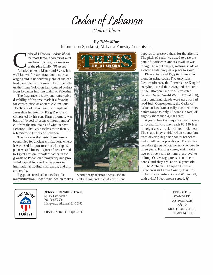
Alabama’s TREASURED Forests513 Madison AvenueP.O. Box 302550Montgomery, Alabama 36130-2550
CHANGE SERVICE REQUESTED
PRESORTED STANDARD
U.S. POSTAGE PAID
MONTGOMERY ALPERMIT NO 109
Cedar of Lebanon, Cedrus libani,the most famous conifer of west-ern Asiatic origin, is a memberof the pine family (Pinaceae).
A native of Asia Minor and Syria, it iswell known for scriptural and historicalorigins and is undoubtedly one of the ear-liest trees planted by man. The Bible tellsus that King Solomon transplanted cedarsfrom Lebanon into the plains of Palestine.
The fragrance, beauty, and remarkabledurability of this tree made it a favoritefor construction of ancient civilizations.The Tower of David and the temple inJerusalem initiated by King David andcompleted by his son, King Solomon, wasbuilt of “wood of cedar without number”cut from the mountains of what is nowLebanon. The Bible makes more than 50references to Cedars of Lebanon.
The tree was the basis of numerouseconomies for ancient civilizations whereit was used for construction of temples,palaces, and boats. Export of cedar woodto Egypt was an important factor in thegrowth of Phoenician prosperity and pro-vided capital to launch enterprises ininternational trading, navigation, and artsand crafts.
Egyptians used cedar sawdust formummification. Cedar resin, which makes
wood decay-resistant, was used inembalming and to coat coffins and
papyrus to preserve them for the afterlife.The pitch of cedar was used to ease thepain of toothaches and its sawdust wasthought to repel snakes, making shade ofa cedar a relatively safe place to sleep.
Phoenicians and Egyptians were notalone in using cedar. The Assyrians,Nebuchadrezzar, the Romans, the King ofBabylon, Herod the Great, and the Turksin the Ottoman Empire all exploitedcedars. During World War I (1914-1918),most remaining stands were used for rail-road fuel. Consequently, the Cedar ofLebanon has dramatically declined in itsnative range to only 12 stands, a total ofslightly more than 4,000 acres.
A grand tree that requires lots of spaceto spread fully, it may reach 80-140 feetin height and a trunk 4-8 feet in diameter.The shape is pyramidal when young, buttrees develop huge horizontal branchesand a flattened top with age. The attrac-tive dark green foliage persists for two tothree years. Fruiting cones, which taketwo or three years to mature, are oval tooblong. On average, trees do not bearcones until they are 40 or 50 years old.
The Alabama Champion Cedar ofLebanon is in Lamar County. It is 125inches in circumference and 61 feet tall,with a 61.75 feet crown spread.
Cedrus libani
By Tilda MimsInformation Specialist, Alabama Forestry Commission
OF • ALABAMA
Pho
tos
by T
ilda
Mim
s