Embed Size (px)
Citation preview
16 What makes a disaster? A long-termview of volcanic eruptions and humanresponses in Papua New GuineaROBIN TORRENCE
VULNERABLE OR RESILIENT?
Modern scholars of natural hazards predict that in developed countries withcomplex, state-level social organisations, disasters can be mitigated through aidprogrammes, redistribution of resources, etc., whereas egalitarian societies withsmaller social networks have a wide range of responses, but are more likely to failto adapt and will abandon their homeland (e.g. Chester, 1993: table 8.4).Anthropologists have often painted quite a different picture in which traditionalsocieties are and have been very resilient and adaptable in the face of extremeclimatic events. In their view modernisation has often undermined capabletraditional means for coping with hazards. They therefore argue that thevulnerability of indigenous groups witnessed in recent disasters is a result of theirmarginalisation through globalisation and externally forced changes (e.g. Oliver-Smith, 1996: 312–14).
A comparison by Sheets et al. (1991; cf. Sheets and McKee, 1994) of theprehistory of the Arenal Valley in Costa Rica with that of El Salvador and Panamasubstantiates the wider anthropological view that simple societies are quiteresilient or even adapted to environmental hazards. Despite the occurrence of tenvolcanic eruptions in Costa Rica during a period of 4,000 years, the archaeologistshave reconstructed a quite remarkable picture of cultural stability. In contrast,they concluded that a major eruption of Ilopango volcano in El Salvador haddisastrous consequences for Mayan civilisation and the Baru volcano severelyundermined the prehistoric Bariles chiefdom society in Panama. According toSheets et al. (1991: 446), simpler societies ‘appear to be more resilient in the after-math of explosive eruptions’ than more complex societies because the latter aredependent on a built environment and economies characterised by ‘occupationalspecialisation, redistribution, and long distance trade routes’. These conclusions arelimited, however, because the authors do not adequately account for differences inthe severity of the events they have compared.
One of the problems with trying to develop a general understanding of the
VOLCANIC ERUPTIONS AND HUMAN RESPONSES, PAPUA NEW GUINEA 293
impact of extreme events on human societies is that scholars often focus onparticular cases which we call ‘disasters’. Since a disaster is defined as a situation forwhich there is a failure to cope, only one possible outcome is considered. Conse-quently, we know far too little about the whole range of situations, includingthose in which there is little if any impact. In addition, the focus on the disasteritself has drawn attention away from how societies recover and the very long-term, follow-on effects of the events. The focus only on hazards that have hadcatastrophic consequences for societies therefore makes it difficult to understandthe broader relationships between the nature of extreme climatic events andhuman responses. Furthermore, this approach has led to an overemphasis on thevulnerability of societies as the most important variable and has ignored differ-ences in the character of the natural events that trigger disasters. I think that thisone-sided view combined with the inattention to variability has led to the paucityof theory to explain why disasters take place in particular social contexts and notin others (cf. Oliver-Smith, 1996: 320).
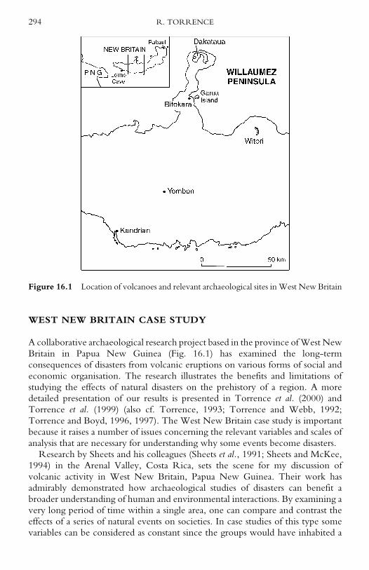
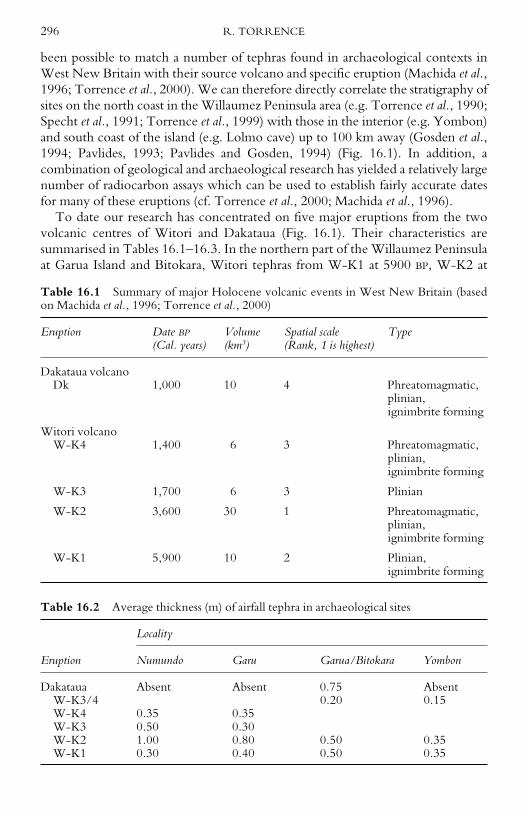
In this chapter I propose that archaeological case studies can make an importantcontribution to a broader understanding of what does and does not make adisaster. They can also provide data that enable a more careful consideration of thedifferent kinds of consequences that follow from variations in social and environ-mental contexts. By examining the history of an area which has experienced anumber of natural events with differing levels of severity and that have occurredover a relatively long time period, one can compare and contrast the impactson a range of societies within the same general environmental setting. In thisapproach the emphasis on ‘disaster’ as the only outcome is diverted to a moredetailed assessment of variation in the nature of the impacts on human groups. Iillustrate the value of research of this type by summarising the findings of anarchaeological investigation into the effects of a series of volcanic eruptions overat least 6,000 years in the province of West New Britain in Papua New Guinea(Fig. 16.1).
The archaeological case study also raises some important points about the theoryand methodology of disaster research. It is shown that problems confronted in thearchaeological analysis, particularly in terms of the methods for measuring theseverity of events and for monitoring impacts on societies, are as yet not fullydeveloped and need more careful consideration. Second, I argue that we need tolook at a wider range of factors when evaluating why some events led to disastersand others did not. Not only are social variables important, as stressed by modernhazard managers and Sheets et al. (1991), but more care needs to be taken tounderstand the impacts on the natural environment and the follow-on effectsover the longer term. Finally, the difficult issue of choosing the appropriatetemporal and spatial scales both for monitoring impacts and for understandinghow societies recover from disasters is discussed. Although solutions are notfound for all the limitations identified, the long-term perspective derived fromarchaeological case studies is clearly shown to provide new insights into howdisasters can be defined and monitored.
294 R. TORRENCE
WEST NEW BRITAIN CASE STUDY
A collaborative archaeological research project based in the province of West NewBritain in Papua New Guinea (Fig. 16.1) has examined the long-termconsequences of disasters from volcanic eruptions on various forms of social andeconomic organisation. The research illustrates the benefits and limitations ofstudying the effects of natural disasters on the prehistory of a region. A moredetailed presentation of our results is presented in Torrence et al. (2000) andTorrence et al. (1999) (also cf. Torrence, 1993; Torrence and Webb, 1992;Torrence and Boyd, 1996, 1997). The West New Britain case study is importantbecause it raises a number of issues concerning the relevant variables and scales ofanalysis that are necessary for understanding why some events become disasters.
Research by Sheets and his colleagues (Sheets et al., 1991; Sheets and McKee,1994) in the Arenal Valley, Costa Rica, sets the scene for my discussion ofvolcanic activity in West New Britain, Papua New Guinea. Their work hasadmirably demonstrated how archaeological studies of disasters can benefit abroader understanding of human and environmental interactions. By examining avery long period of time within a single area, one can compare and contrast theeffects of a series of natural events on societies. In case studies of this type somevariables can be considered as constant since the groups would have inhabited a
Figure 16.1 Location of volcanoes and relevant archaeological sites in West New Britain
295VOLCANIC ERUPTIONS AND HUMAN RESPONSES, PAPUA NEW GUINEA
roughly similar environment and are likely to have shared cultural traditions.Sheets et al. (1991) were unable to link the incidence of volcanic events to majorcultural changes and therefore concluded that in this case the societies wereextremely resilient.
Although they may be correct, I feel that they have not adequately consideredthe relatively low severity of the eruptions they have studied. If the impacts of theArenal eruptions were not very serious, then there would have been no reason forchange, regardless of the nature of the society at the time. Indeed, this seems tohave been the case. The volume of downwind tephra for the nine eruptionsaveraged 0.16 km3 and was never larger than 0.3 km3 (Melson, 1994: 39) and thestresses on vegetation are assumed to have ‘become small at 20 km to 30 km’ fromthe volcano (Sheets, 1994: 325). In contrast, Sheets et al. (1991) propose that theIlopango eruption had a greater impact because complex societies are moresusceptible to disasters. However, the Ilopango eruption, with a volume of 30km3, was many orders of magnitude larger than the Arenal eruptions. It had a verygreat environmental impact and destroyed vegetation and human constructionsover thousands of square kilometres (Sheets, 1979). It therefore seems likely thatthe relative scales of the natural hazards discussed by Sheets et al. (1991) played atleast as much a part in causing the different outcomes as did the variation in thesocial organisation of the groups affected by the volcanic eruptions.
The West New Britain study has also compared the social and cultural effects ofevents with varying degrees of severity, although all the eruptions were consider-ably larger than those of Arenal. As in Costa Rica the fairly egalitarian societies ofPapua New Guinea were also very resistant to major change despite facing poten-tially much more serious catastrophes, but there was nevertheless considerablevariability in how these societies responded to the different events. In some casesthe volcanic eruptions caused serious human disasters, whereas for others theeffects were either less problematic or, when viewed over a long time span, werenot disasters at all. Although the data demonstrate that vulnerability is importantfor understanding disasters, the long-term archaeological studies illustrate that thenature of the triggering factor also causes variation in human responses. Thisseemingly obvious fact appears to have been overlooked in some studies ofdisasters. As illustrated below, then, the first step in analysing the impacts of asevere natural event is to assess its severity independent of its effects on culturalprocesses.
Severity of eruptionsWhereas volcanic eruptions may have had disastrous effects on human popula-tions, they can have enormous benefits for archaeological research. The tephrasfrom these short-lived, specific events provide distinctive marker beds to establisha relative chronology and can often be applied to a very large region (e.g. Machidaand Sugiyama, Chapter 17, this volume; Dugmore, 1989; Sheets and Grayson,1979; Pilcher and Hall, 1996; Sheets et al., 1991; Sheets and McKee, 1994;Zeidler and Isaacson, 1999). Using a combination of stratigraphy, macroscopicproperties, refractive indices, and SEM microprobe geochemical analysis, it has
296 R. TORRENCE
been possible to match a number of tephras found in archaeological contexts inWest New Britain with their source volcano and specific eruption (Machida et al.,1996; Torrence et al., 2000). We can therefore directly correlate the stratigraphy ofsites on the north coast in the Willaumez Peninsula area (e.g. Torrence et al., 1990;Specht et al., 1991; Torrence et al., 1999) with those in the interior (e.g. Yombon)and south coast of the island (e.g. Lolmo cave) up to 100 km away (Gosden et al.,1994; Pavlides, 1993; Pavlides and Gosden, 1994) (Fig. 16.1). In addition, acombination of geological and archaeological research has yielded a relatively largenumber of radiocarbon assays which can be used to establish fairly accurate datesfor many of these eruptions (cf. Torrence et al., 2000; Machida et al., 1996).
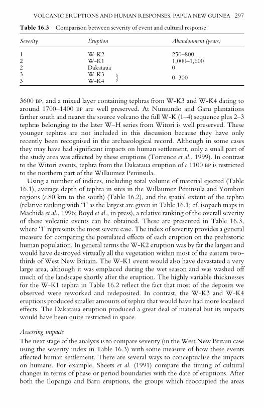
To date our research has concentrated on five major eruptions from the twovolcanic centres of Witori and Dakataua (Fig. 16.1). Their characteristics aresummarised in Tables 16.1–16.3. In the northern part of the Willaumez Peninsulaat Garua Island and Bitokara, Witori tephras from W-K1 at 5900 BP, W-K2 at
Table 16.1 Summary of major Holocene volcanic events in West New Britain (basedon Machida et al., 1996; Torrence et al., 2000)
Eruption Date BP Volume Spatial scale Type(Cal. years) (km3) (Rank, 1 is highest)
Dakataua volcanoDk 1,000 10 4 Phreatomagmatic,
plinian,ignimbrite forming
Witori volcanoW-K4 1,400 6 3 Phreatomagmatic,
plinian,ignimbrite forming
W-K3 1,700 6 3 Plinian
W-K2 3,600 30 1 Phreatomagmatic,plinian,ignimbrite forming
W-K1 5,900 10 2 Plinian,ignimbrite forming
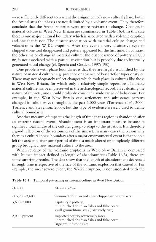
Table 16.2 Average thickness (m) of airfall tephra in archaeological sites
Locality
Eruption Numundo Garu Garua/Bitokara Yombon
Dakataua Absent Absent 0.75 AbsentW-K3/4 0.20 0.15W-K4 0.35 0.35W-K3 0.50 0.30W-K2 1.00 0.80 0.50 0.35W-K1 0.30 0.40 0.50 0.35
297VOLCANIC ERUPTIONS AND HUMAN RESPONSES, PAPUA NEW GUINEA
3600 BP, and a mixed layer containing tephras from W-K3 and W-K4 dating toaround 1700–1400 BP are well preserved. At Numundo and Garu plantationsfarther south and nearer the source volcano the full W-K (1–4) sequence plus 2–3tephras belonging to the later W–H series from Witori is well preserved. Theseyounger tephras are not included in this discussion because they have onlyrecently been recognised in the archaeological record. Although in some casesthey may have had significant impacts on human settlement, only a small part ofthe study area was affected by these eruptions (Torrence et al., 1999). In contrastto the Witori events, tephra from the Dakataua eruption of c.1100 BP is restrictedto the northern part of the Willaumez Peninsula.
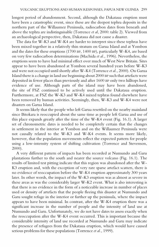
Using a number of indices, including total volume of material ejected (Table16.1), average depth of tephra in sites in the Willaumez Peninsula and Yombonregions (c.80 km to the south) (Table 16.2), and the spatial extent of the tephra(relative ranking with ‘1’ as the largest are given in Table 16.1; cf. isopach maps inMachida et al., 1996; Boyd et al., in press), a relative ranking of the overall severityof these volcanic events can be obtained. These are presented in Table 16.3,where ‘1’ represents the most severe case. The index of severity provides a generalmeasure for comparing the postulated effects of each eruption on the prehistorichuman population. In general terms the W-K2 eruption was by far the largest andwould have destroyed virtually all the vegetation within most of the eastern two-thirds of West New Britain. The W-K1 event would also have devastated a verylarge area, although it was emplaced during the wet season and was washed offmuch of the landscape shortly after the eruption. The highly variable thicknessesfor the W-K1 tephra in Table 16.2 reflect the fact that most of the deposits weobserved were reworked and redeposited. In contrast, the W-K3 and W-K4eruptions produced smaller amounts of tephra that would have had more localisedeffects. The Dakataua eruption produced a great deal of material but its impactswould have been quite restricted in space.
Assessing impactsThe next stage of the analysis is to compare severity (in the West New Britain caseusing the severity index in Table 16.3) with some measure of how these eventsaffected human settlement. There are several ways to conceptualise the impactson humans. For example, Sheets et al. (1991) compare the timing of culturalchanges in terms of phase or period boundaries with the date of eruptions. Afterboth the Ilopango and Baru eruptions, the groups which reoccupied the areas
Table 16.3 Comparison between severity of event and cultural response
Severity Eruption Abandonment (years)
1 W-K2 250–8002 W-K1 1,000–1,6002 Dakataua 03 W-K3 0–3003 W-K4 }
298 R. TORRENCE
were sufficiently different to warrant the assignment of a new cultural phase, but inthe Arenal area the phases are not delimited by a volcanic event. They thereforeconclude that the Arenal societies were more resistant to change. Changes inmaterial culture in West New Britain are summarised in Table 16.4. In this casethere is one major cultural boundary which is associated with a volcanic eruptionand one that is not. The clearest association with material culture change andvolcanism is the W-K2 eruption. After this event a very distinctive type ofchipped stone tool disappeared and pottery appeared for the first time. In contrast,the other major change in material culture, the disappearance of pottery c.2,000BP, is not associated with a particular eruption but is probably due to internallygenerated social change (cf. Specht and Gosden, 1997: 190).
One problem with phase boundaries is that they are largely established by thenature of material culture: e.g. presence or absence of key artefact types or styles.These may not adequately reflect changes which took place in cultures like thosein West New Britain, for which only a relatively simple repertoire of durablematerial culture has been preserved in the archaeological record. In evaluating thenature of impacts, one should probably consider a wide range of behaviour. Forexample, in the West New Britain case settlement and subsistence patternschanged in subtle ways throughout the past 6,000 years (Torrence et al., 2000;Torrence and Stevenson, 2000), but this type of evidence is rarely used to definecultural boundaries.
Another measure of impact is the length of time that a region is abandoned afteran extreme natural event. Abandonment is an important measure because itsignifies a total failure of the cultural group to adapt to the situation. It is thereforea good reflection of the seriousness of the impact. In many cases the reason whythere is a cultural phase boundary after a major environmental event is that peopleleft the area and, after some period of time, a much altered or completely differentgroup brought a new material culture to the area.
When severity of the volcanic eruptions in West New Britain is comparedwith human impact defined as length of abandonment (Table 16.3), there aresome surprising results. The data show that the length of abandonment decreasedthrough time irrespective of the size of the volcanic explosion that caused it. Forexample, the most severe event, the W-K2 eruption, is not associated with the
Table 16.4 Temporal patterning in material culture in West New Britain
Date BP Material culture
?>5,900–3,600 Stemmed obsidian and chert chipped stone artefacts
3,600–2,000 Lapita style pottery,unretouched obsidian flakes and flake cores,small groundstone axes (extremely rare)
2,000–present Imported pottery (extremely rare)unretouched obsidian flakes and flake cores,large groundstone axes
299VOLCANIC ERUPTIONS AND HUMAN RESPONSES, PAPUA NEW GUINEA
longest period of abandonment. Second, although the Dakataua eruption musthave been a catastrophic event, since these are the deepest tephra deposits in thenorthern part of the Willaumez Peninsula, radiocarbon dates from beneath andabove the tephra are indistinguisable (Torrence et al, 2000: table 2). Viewed froman archaeological perspective, then, Dakataua did not cause a disaster.
The data for W-K3 and W-K4 are harder to interpret since these tephras havebeen mixed together in a relatively thin stratum on Garua Island and at Yombonand the dates for these eruptions (1700 BP, 1400 BP), particularly W-K4, are basedon very few radiocarbon determinations (Machida et al., 1996). Nevertheless, theeruptions seem to have had minimal effect over much of West New Britain. Sitesappear to have been abandoned at Yombon several hundred years before W-K3and were not occupied until shortly after W-K4 (Torrence et al., 2000). On GaruaIsland there is a change in land use beginning about 2000 BP such that artefacts weredeposited in fewer places than previously and after 1600 BP only two hilltops haveevidence of use. Although parts of the island may have been abandoned,the site of FSZ continued to be actively used until the Dakataua eruption.Furthermore, at FSZ the W-K3 and W-K4 mixed tephras found elsewhere havebeen removed by human activities. Seemingly, then, W-K3 and W-K4 were notdisasters on Garua Island.
It seems likely that the people who left Garua resettled on the nearby mainlandsince Bitokara is reoccupied about the same time as people left Garua and use ofthis place expands greatly after the time of the W-K4 event (Fig. 16.1). A largerset of chronometric dates is needed to be completely certain that the changesin settlement in the interior at Yombon and on the Willaumez Peninsula werenot causally related to the W-K3 and W-K4 events. It seems more likely,however, that the population movements reflect the expected pattern for peopleusing a low-intensity system of shifting cultivation (Torrence and Stevenson,2000).
A very different pattern of impacts has been recorded at Numundo and Garuplantations further to the south and nearer the source volcano (Fig. 16.1). Theresults of limited test pitting indicate that this region was abandoned after the W-K3 eruption and, with the exception of very rare sparse artefact scatters, there isno evidence of reoccupation before the W-K4 eruption approximately 300 yearslater. In other words, the impact of the W-K3 eruption was as almost as severe inthese areas as was the considerably larger W-K2 event. What is also interesting isthat there is no evidence in the form of a noticeable increase in number of placesused or density of artefacts that the people fleeing this disaster at Numundo andGaru sought refuge in the interior or further up the peninsula, where the impactappears to have been minimal. In contrast, after the W-K4 eruption there was asignificant increase in the number of people and the intensity of land use atNumundo and Garu. Unfortunately, we do not have dates to assess exactly whenthe reoccupation after the W-K4 event occurred. This is important because theconsiderable intensity of land use recorded at Numundo and Garu may indicatethe presence of refugees from the Dakataua eruption, which would have causedserious problems for these populations (Torrence et al., 1999).
300 R. TORRENCE
INTERPRETING IMPACTS
The brief summary of the Witori and Dakataua events demonstrates that there is nosimple, direct relationship between the severity of the volcanic eruptions and thecultural responses in West New Britain. If we accept Sheet et al.’s (1991) findings,then the explanation for variation in responses should be accounted for bydifferences in social organisation. The data discussed below illustrate that thesituation is much more complex. In my view one needs to take a more compre-hensive look and consider a much broader range of factors that would haveaffected the way human groups were able to respond to the volcanic eruption. Tobegin with, environmental damage needs to be assessed. In the followingdiscussion I consider gross changes in topography and physiography as well asdamage to vegetation and processes of forest regeneration. Second, in orderto assess cultural vulnerability, variation in economic and social organisation isconsidered.
Landscape changesVolcanic eruptions can cause a total alteration of the landscape, especially near thesource. Away from the centre of activity the major changes in topography arecaused by airfall tephra. The emplacement of tephra up to 50 cm thick over alandscape will significantly alter the overall topography (i.e. by smoothing overrough surfaces, decreasing slopes, infilling valleys, changing of drainage patternsetc.), which has implications for human settlement, especially when combinedwith the erosional processes that follow (Boyd and Torrence, 1996). In additionto impacts on raw material extraction (Torrence et al., 1996) and subsistencepatterns, these changes can markedly affect the social and sacred landscapes sothat, for example, ‘special’ places, trails and territorial markers are no longerrecognisable and/or lose their meaning. The main changes in behaviour due tolandscape alteration that we have traced relate to the creation of beaches and inplaces an extensive coastal plain (cf. Gosden and Webb, 1994). On Garua Islandthe emplacement of the W-K2 tephra created a new strip of land surroundingparts of the island and subsequent settlement focused on the new coastal plainbefore moving into the uplands (Torrence and Boyd, 1997; Torrence andStevenson, 2000).
At Numundo Plantation changes in coastal topography had more profoundeffects on settlement. From our very preliminary survey work, we can track theevolution of the current coastal plain during the past 6,000 years from shallowwater to dry land as a result of infilling from the Witori W-K1–4 airfall tephras anddeposition of additional tephras eroded from the surrounding hillsides. As theplain filled in, the number of ecozones (e.g. shallow water, reef, mangroves,swamp, lakes, etc.) expanded after W-K2 and then declined after W-K3. As aconsequence, the intensity of human use shifted from dispersed over the wholearea (pre-W-K2), to concentrated near the coast (post-W-K2), and then to amixed use of foothills for settlement and coastal plain for agriculture (post-W-K4). It seems likely that the long abandonment period after the W-K3 eruption in
301VOLCANIC ERUPTIONS AND HUMAN RESPONSES, PAPUA NEW GUINEA
this region may have resulted from the destruction of many of the productiveshallow-water swamps and mangroves. In contrast, one factor in the markedincrease in intensity of land use after W-K4 might have been the expansion of dry,low-lying areas suitable for agriculture as a consequence of the emplacement ofthe tephra (cf. Torrence et al., 1999).
RegenerationThe speed and nature of forest regeneration should be critical in determining thepotential for human recolonisation of an area after a volcanic eruption. Thelength of time for complete regeneration depends on the extent of destruction,which in turn is caused by the chemical composition, physical properties (e.g.grain size, porosity) and depth of the tephra. Airfall tephra with depths up to 50cm, as in the case of the W-K1, W-K2 and Dakataua events, would have totallyannihilated the ground cover and stripped most, if not all, of the canopy of itsleaves and branches (Blong, 1984: 316–25). A recent case study of the 1994Rabaul eruption found that in depths less than 20 cm, trees were defoliated butmany plants were able to regenerate from suckers and roots, whereas tephragreater than 50 cm caused severe problems. Replanting was also difficult in areasof thick tephra deposits because of ‘calcium, phosphorous and potassiumdeficiencies, high salt concentrations in the tephra, low nutrient holding capacity,and absence of a balanced soil ecology’ (Lentfer et al., in press). In places wherethe tephra fall was 1–15 cm there was good recovery of gardens once the rains hadcome. In some cases the regrowth was extremely lush because of the addednutrients derived from the decayed plant matter buried under the ash (ibid.).
On the whole, one can predict that the length of time for recovery would bedirectly correlated with the severity index I have used to compare the West NewBritain eruptions, since it was calculated in terms of both the depth and arealextent of the tephra. Spatial extent of the destruction is critical because recolonis-ation of vegetation depends on sea, water and animal transport of plant propagules.Given the history of recolonisation on Krakatau – such that a rainforest currentlystands on islands where all living matter had been completely obliterated in 1883(Thornton, 1996), one would expect that 100 years would have been adequatefor full forest cover even after the most severe eruptions, although the inlandregions might have required a bit longer because of the increased distance fromseed banks.
Although tropical forests can regenerate quite quickly, the types and variety ofspecies present may vary widely because succession has a very significant randomelement to it. For example, Krakatau may be totally reforested today, but thenumber of species is quite low compared to before the eruption and, due to thevagaries of history, a very different suite of both animal and plant species hasrecolonised the various island remnants of the original caldera (Thornton, 1996).In contrast, in their study of revegetation on Vulcan volcano at Rabaul, Lentfer etal. (in press) found that the composition of the early plant colonisers was verysimilar to that recorded for Krakatau, suggesting some measure of determinism inthe early stages of the regeneration process. Research on how vegetation recovery
302 R. TORRENCE
took place in West New Britain has recently been initiated using the analysisof phytoliths (Boyd et al., 1998), starch grains (Therin et al., 1999) and pollen(Torrence et al., 1999).
Species composition would have been extremely important to hunter-gatherers or forest managers (i.e. low-intensity, shifting agriculturalists). If, as aconsequence of random events, the post-eruption forest contained a largernumber of fruit or nut trees or tubers, then it might have lent itself to intensiveculling and/or management and permitted higher population densities thanpreviously. Obviously the reverse is also true. Furthermore, food plants tend to bemore common in the early stages of forest succession, and some sources of foodsuch as fruits and nuts are much easier to harvest before the full canopy develops.Returning sooner, rather than later, in the sequence of forest succession couldtherefore have had advantages in terms of harvesting or managing of wild plantresources.
Part of the observed temporal trend in the length of abandonment maytherefore have been caused by differences in the way reforestation occurred, butit is difficult to argue that the extremely long periods of abandonment afterthe first two eruptions, 1,000 and 250 years respectively, can be satisfactorilyexplained by environmental factors alone. Furthermore, the human response tothese environmental factors would not have been direct, but would have beenmediated by cultural factors. For example, at a very simple level it is quite clearthat societies practising agriculture could have recolonised the region at differentspeeds and in different ways than would be the pattern with hunter-gatherers.
Subsistence and settlementThe resilience of the various societies in the face of the volcanic eruptions and theirability to recolonise at different speeds would have depended at least inpart on the patterns of subsistence and settlement which they practised.Archaeological research in the province has revealed that despite the punctuatedenvironmental record, the nature of subsistence and settlement changed in adirectional manner. A gradual shift through time from a focus on the productionof multi-purpose, retouched, chipped stone artefacts (‘stemmed tools’) to theproduction and use of expediently manufactured, unretouched flakes has beenproposed as the result of a decrease in mobility (Torrence et al., 2000; Torrence,1992, 1994; Fullagar, 1992; Kealhofer et al., 1999). Data on changes in thedistribution of artefacts across space on Garua Island (Torrence et al., 2000) andYombon (Pavlides, 1999) from dispersed to clustered appear to indicate there was agradual reduction in mobility through time, paralleling the shifts in technologicalorganisation of stone tools. Studies of starch grain assemblages recovered from siteson Garua Island and at Bitokara have also been interpreted to indicate a higherdegree of sedentism through time (Therin et al., 1999). I have proposed that thesechanges in lithics and settlement patterns are part of a more general processinvolving a gradual intensification in the management of plant resources throughtime (Torrence, 1992, 1994; Torrence et al., 2000).
If, for whatever reasons, people were increasingly managing their resources so
303VOLCANIC ERUPTIONS AND HUMAN RESPONSES, PAPUA NEW GUINEA
as to get higher returns per unit area, it seems likely that they would have beenable to colonise a new region more quickly. Along similar lines, if they weregardening tubers and could clear the ash from their plants or had an alternativesource of new tubers, then they could return permanently within a year after aneruption – if the ash was less than 50 cm – and rather more slowly in worse-affected areas which require the addition of nutrients and the restoration ofparticular soil properties (cf. Lentfer et al., in press). It therefore seems likelythat the linear change in subsistence pattern, which is inferred from the lithicsand settlement data, took place independently of the history of eruptions butwas critical in accounting for the temporal trend toward increasingly rapidrecolonisation.
Social organisationAlthough Sheets et al. (1991) were correct to recognise the importance of socialorganisation as a factor in how disasters are caused and managed, in the case ofWest New Britain, their prediction that complex social organisations are lesssensitive to environmental perturbation than simpler societies fails to explain theobserved pattern. Throughout the time period considered the social groupsappear to have been relatively egalitarian societies. There is little evidence formajor changes in the complexity of the social organisations in this region duringprehistory, although the nature and role of prestige goods were not stable. Socialdifferences are nevertheless implicated in the long-term trend toward smallerperiods of abandonment after the volcanic eruptions because the nature and speedof recolonisation cannot be explained solely by the severity of the event in termsof damage to the environment.
The most important social implication for understanding variation in thenature of recolonisation is that it cannot be understood as a purely local process.After an extreme event people need social ties that allow them to take refugeelsewhere, even if only temporarily. If not, they will perish. Part of the variationin recolonisation witnessed in the West New Britain data must be due to thepresence or absence of and/or differences in the social linkages between thevictims and their neighbours or with more distant people with whom they couldshelter. Where they could have sheltered and for how long would have dependedon the nature of their social ties with groups outside the affected area, whether theimmigrants could have been incorporated within the social practices and landtenure arrangements of their allies, and the potential of the resources in theseplaces to support increased population. Whereas finding temporary refuges mighthave been relatively easy, maintaining a satisfactory existence away from thehomeland on a very long-term basis might not have been possible.
In all the cases that we have monitored in West New Britain, the thickness ofthe tephra was such that sources of food would have been destroyed and freshwater would also have been badly affected. If the event occurred in the dry season,as was the case in the Rabaul 1994 eruption, people might have had to wait aslong as six months for rains leading to natural regeneration or the revitalisation ofgardens (cf. Lentfer et al., in press). For the W-K1, W-K2 and Dakataua events
304 R. TORRENCE
throughout the region and for W-K3 and W-K4 at Numundo and Garu, theenvironmental damage would have been so extensive that people could not haverecolonised for some years even if they were able to replant their gardens.
Survival in these cases would have been completely contingent on havingsocial relations elsewhere. Since the spatial scale of the eruptions differed,however, the scale and nature of the social linkages required to enable safe refugeswould have varied. So, for example, groups surviving the W-K1 or W-K2 disasterwould have needed friends and relations at much greater distances than thoseexperiencing the impacts of the less spatially extensive Dakataua, W-K3 or W-K4eruptions. It seems very likely that the much longer times for reoccupation afterW-K1 and W-K2 indicate that local groups were not able to seek refuge and didnot survive. In contrast, the rapid resettlement after Dakataua implies that theoriginal residents may have been responsible for the recolonisation.
It is difficult to obtain accurate comparisons toward the length of social ties atvarious times in the prehistory of West New Britain given current data. Obsidianfrom the Bismarck Archipelago outcrops has been recovered from sites located inmany areas of Melanesia and dating to all the periods we have studied (e.g. White,1996). After the W-K2 eruption, obsidian is found over a larger area than inprevious periods. This pattern suggests the presence of wider cultural links. At thissame time people were decorating their pottery with motifs that are also sharedover a very large region extending as far as Tonga and Samoa (e.g. Summerhayes,2000). The wider regional social ties could help explain the shorter length ofdepopulation when compared to the W-K1 eruption. Kirch (1988) has suggestedthat the fairly rapid speed of the colonisation throughout Near Oceania of peoplebearing the Lapita decorated pottery was facilitated by social links betweencommunities such as are reflected in the distribution of obsidian from West NewBritain. From about 2,000 years ago onward, obsidian movement is morerestricted in space, but there is an expansion into newer areas, such as the PapuaNew Guinea Highlands region (White, 1996: 201). Clearly, there was a re-orientation in the location of social links, but currently we are unable to assessprecisely how these data relate to differences in the length and strength of socialnetworks. Although we can infer that variations in the social make-up of thesocieties involved must have greatly affected rates of recolonisation in West NewBritain, it is difficult to accurately monitor these differences with currentarchaeological data, although this should be pursued in future work.
We also need to invoke social differences in explaining the long-term trend fora reduction in the length of abandonment because the ability to bud off from alarger social group or to organise a mass movement of people is an explicitly socialprocess. Relatively rapid recolonisation of an area which has been totally deci-mated would also have required means for buffering failures, such as ways to securelinks with people remaining behind and/or efficient means for redistributingresources. Small groups with fewer social ties are likely to have been less successfulat supporting themselves at an early stage of natural regeneration, but could haverecolonised later in the succession when food supplies were more abundant.
In summary, understanding the impacts of the various eruptions requires a
305VOLCANIC ERUPTIONS AND HUMAN RESPONSES, PAPUA NEW GUINEA
great deal of geological, environmental and archaeological data. At this stage much ofthis is not yet available in adequate detail to assess fully the relative importance of theenvironmental changes brought by the volcanic events in West New Britain versusthe vulnerability of the societies, as monitored by their economic and socialorganisation. Nevertheless, the case study demonstrates the importance ofconsidering a wide number of factors rather than concentrating solely on thevulnerability of the societies themselves. Furthermore, given the small amount ofvariation in the social organisations present in the study region, it is obvious that theseverity of the event was a critical variable. Finally, a number of methodologicalproblems have been faced in trying to sort out the various impacts, and thesedeserve more serious discussion.
METHODOLOGICAL ISSUES
The most serious methodological issues identified by the West New Britain casestudy are limitations in the way impacts are assessed by archeologists and problemswith selecting appropriate spatial and temporal scales for monitoring the effectsof the eruptions. For the West New Britain case study I have used length ofabandonment as a rough measure of the impact of volcanic events on thecontemporary human societies. As a first stage, this is a reasonable way to comparedisasters occurring in the same area, but detailed comparison between regions inother parts of the world would be more difficult because potential rates ofrecovery are necessarily linked to local environmental conditions. This measure isalso limited because the character and speed of landscape recovery is unlikely tobe identical after different events due to landscape changes caused by lavas andairfall tephras and the stochastic nature of forest regeneration.
An alternative measure of impact is the degree to which the trajectory ofcultural change parallels that of disasters. So, for example, Sheets et al. (1991)consider the chronological relationship between cultural phase boundaries andvolcanic eruptions. The prehistory of West New Britain illustrates a difficultywith using this approach on its own. In the case of the W-K1 event there was noappreciable change in the artefact assemblages before and after the eruption, but avery large area appears to have been abandoned for 1,000 years afterwards.Obviously, the local population was seriously affected by this event. On the otherhand, the wider region, which was the source of the populations who recolonisedthe affected area, probably did not face a disaster and maintained the sametechnological system outside the affected region. The opposite took place afterthe W-K2 eruption. Major cultural changes took place outside West New Britainduring the time the area was abandoned and so the colonisers brought with them avery different set of material culture items. Whether the impact of people fleeingthe region and taking refuge elsewhere had a role to play in the development ofthese new cultural items or the process was completely external to the volcaniceruptions cannot be determined solely from a study of West New Britain itself,but is a research topic worth pursuing.
306 R. TORRENCE
Although each provides a gross index of how volcanic events have affectedpopulations, neither the cultural phase nor length of abandonment approach tomonitoring cultural responses is completely satisfactory, mainly because eachfocuses on very large-scale changes and glosses over the complexity in the data.New approaches to assessing impacts are needed that examine a wider range ofeffects.
Possibly the most important methodological issue to be faced when assessingthe nature of disasters is choosing the spatial scale of analysis. First, one needs away to determine the size of the area directly affected by the volcanic eruption.For this one could use a simple measure such as depth of tephra. The seconddifficulty is locating the areas which suffered indirect effects. Surroundingpopulations could have been affected because they provided food and shelter forrefugees and may have made adjustments to enable settlement of refugees on along-term basis. Even further afield, other areas may have suffered becausetrading links with an affected area were disrupted. In addition, some places mayeven have benefited through loss of competition or disruption of trading net-works (cf. Sheets, 1979).
A second methodological issue is the selection of the spatial scale for analysis.The West New Britain study shows that spatial scales are particularly importantwhen trying to understand the process of recolonisation. In the case of the W-K1and W-K2 eruptions, when the region was abandoned for many generations, therecolonising population must have comprised a different group of people fromthe former inhabitants and one that may have had tenuous connections to thisarea. The case for population replacement is less clear for recolonisation after theW-K3 and W-K4 events, but the timing and nature of reoccupation mustnevertheless have been determined by the social organisation, subsistence andsettlement patterns of the populations in the surrounding regions. If these hadreached the culturally determined carrying capacity, then the refugee populationmay have been encouraged to return more quickly than if there had beenopportunities for them to be incorporated and so on. A number of scenarios canbe imagined, but all involve consideration of the region (of unknown size anddifferent for each event) outside the affected area.
Since the prehistory of West New Britain can be assumed to have comprised aset of recolonisations by different populations, most likely coming from differentsources, the pattern provided by the archaeological data for a gradual decrease inthe length of abandonment and an increase in the intensification of land use isvery puzzling. One would not have expected a punctuated history of disasters tobe correlated with stability or a slow, gradual cultural change. In particular, thecontinuity in lithic technology before and after the W-K1 disaster is remarkable.How is it that people returned 1,000 years later to the same lithic sources, madedistinctive tools that were the same as before, and generally took up almost wherethey left off? In contrast, abrupt changes, such as the arrival of pottery after theW-K2 event, are quite predictable since the populations may have been quitedifferent. To understand these puzzles, one would have to look outside WestNew Britain to the regions where the colonisers originated.
307VOLCANIC ERUPTIONS AND HUMAN RESPONSES, PAPUA NEW GUINEA
Even without the benefit of having studied a large enough region, some generalpredictions to guide future research can be derived from considering the process ofrecolonisation in West New Britain on an appropriately large spatial scale. First, Iexpect that in the period from c.6,000 to around 5,000 BP, when the affected areaappears to have remained abandoned, other regions did not experience populationstress. Either local solutions were found to cope with rising populations, e.g.subsistence intensification took place, or population size was relatively stable andthere was no stimulus for moving out and colonising new territory. Furthermore,social and ideological factors may not have encouraged movement into the emptyregion.
The timing of repopulation c.3,300 BP, several hundred years after the W-K2event, must also be explained by processes operating outside of West NewBritain. Finally, recolonisation after the Dakataua event appears to have been sorapid that, apart from the fact that this was a more localised catastrophe, theprocess must have differed markedly from previous episodes of recolonisation.
Although in theory one could describe the attributes of the relevant region thatshould be studied, in practice it is difficult to define adequately the nature andlevel of the indirect effects to be studied and to predict exactly where the spatialboundaries of the affected area would have been. Furthermore, as in the case ofthe West New Britain eruptions, where the region that was indirectly affectedwould probably lie outside the island itself, the size of the appropriate study areawould be beyond the capabilities of a single research project.
In addition to selecting the best spatial scale of analysis, the choice of whichchronological scales to study is very important and is also not straightforward.One of the advantages of archaeological research is that it enables one to track thefollow-on effects of a extreme natural hazard over the period anywhere from afew decades to a millennium, depending on the chronological resolution that ispossible (cf. Sheets, 1979: 558; Grayson and Sheets, 1979). Immediately after adisaster people are usually forced to abandon a region, creating a very major short-term impact on their lives. The effect, however, may not be a long-lasting oneand the population may return, clean up the mess, and carry on. Archaeology,which operates over scales rarely less than several generations, may not be able tomonitor adequately the very short-term effects and may be tempted to concludethat the event had no impact. On the other hand, a group may return quickly butbe forced to adopt new patterns of behaviour in order to adapt to its alteredenvironment. Alternatively, groups may have to leave their homes for a very longtime period, in which case the people who recolonise the region may bring manynew cultural practices with them. In both these cases the one-off natural eventhad very major long-term effects, but these occurred at different time scales.From a methodological point of view, it is therefore quite important to analysethe impact of these short-term events over a number of chronological scales. Thispoint is well demonstrated by the wide range of temporal impacts witnessed inprehistoric West New Britain.
With the exception of the W-K3 and W-K4 eruptions as experienced onGarua Island, all the volcanic events in West New Britain that we have studied
308 R. TORRENCE
must have had catastrophic immediate impacts, but there was considerable variation inthe way societies were affected when considered at other time scales. In terms of aslittle as several generations the Dakataua eruption seems to have made very littledifference to population levels in the Willaumez Peninsula. In contrast, over the verylong term of several centuries, the W-K2 event made quite a significant impact on theprehistory of the region. Finally, when viewed over several centuries, the W-K1event caused a complete depopulation of a large region, but considered a millenniumlater, it seems to have had very little effect on the cultural practices in the affectedarea.
Although archaeological data are generally amenable to the study of long-termprocesses, one of the most serious problems is getting good enough chronologicalcontrol to adequately assess the nature and scale of impacts. I have arguedpreviously that studies of volcanic disasters are much aided by the presence ofairfall tephras that can be linked to single events. Although sourced tephras areinvaluable for establishing a relative chronology over sometimes large regions, theirpresence does not solve the need for accurate, short-term dates. For example,material underlying a dated tephra may have no relevant chronological associ-ation with it because it might have been abandoned some considerable timebefore the eruption. If one wants to relate the buried material directly to theeruption, then independent chronometric control is required. Similarly, moni-toring the nature and rates of recolonisation requires excellent chronologicalcontrol. The history of recolonisation in West New Britain presented in Table16.3 is only based on a limited sample of radiocarbon dates (Torrence et al., 2000)and so the patterns which we have detected could be inaccurate. Anotherdifficulty archaeologists face is determining whether a population remained or leftthe area for relatively short periods that may nevertheless have been significant forcultural processes, e.g. several generations, but are too small to be detected giventhe limitations of radiocarbon dating.
Archaeologists need to think hard about what types of questions concerningthe impacts of natural hazards can be answered satisfactorily given the limitationsof their data. As a first step, we should continue to develop better means formeasuring impacts than are commonly used at present. Second, examiningimpacts on a range of spatial and temporal scales is very important for under-standing the wide range of processes that result when an area experiences a severeclimatic event. Finally, we must accept that there are major difficulties in assessingthe degree of short-term impacts on human societies and in tracing indirecteffects over very large regions, particularly if they are as poorly researched as is thecase in Papua New Guinea.
IMPORTANCE OF DISASTER STUDIES
Since the analysis of disasters can make a significant contribution to theories abouthuman social and cultural change, it is important to overcome the methodologicaldifficulties raised above. For example, the long-term history of recolonisation in
309VOLCANIC ERUPTIONS AND HUMAN RESPONSES, PAPUA NEW GUINEA
West New Britain, which is characterised by a series of short-term events that had avariety of impacts on cultural process, has far-reaching implications for currenttheories of culture change. First, the lack of correlation between the severity ofvolcanic events and the impact on societies as measured by the length ofabandonment illustrates the importance of historical contingencies and stochasticelements in long-term cultural processes. Second, environmental factors, such asecological succession and forest regeneration, are unlikely to fully explain thepatterns observed – especially the exceedingly long periods of abandonment inthe early periods and the gradual trend toward increasingly intensified systems ofland management. Third, the pattern of subsistence intensification within WestNew Britain must be explained largely in terms of complex interactions betweensocial processes operating outside the region and the environment of the affectedregion. The decrease in the length of abandonment over time might be assumedto represent some form of long-term ‘adaptation’ to volcanic disasters, but thisexplanation is untenable since the changes in culture reflected in the archaeo-logical record took place outside the region directly affected by the volcanicevents and were then reintroduced into the affected area. If there was any form ofadaptation to the volcanic history of West New Britain, then it took place withinthe wider region which experienced indirect effects of the eruptions. Research-ing this hypothesis demands further research aimed at identifying the homelandsof the people who recolonised the region and a comparison of the cultural historyof these regions with that of West New Britain.
Disaster research also has a significant role to play in archaeology because itfocuses on the fundamental interactions between externally generated environ-mental factors and the way these are perceived and manipulated by humangroups. I have argued that although the study of disasters provides an excellentopportunity for archaeologists to seriously examine important questions con-cerning the cause, speed and direction of culture change, there are a number ofmethodological issues concerning the measurement of impact and spatial andchronological scales that require further study.
Considering the question raised in the title of this chapter – what makes adisaster? – the data from West New Britain illustrate that an answer can be framedon several levels. First, the severity of the natural hazard is very important. Smallereruptions had less impact on societies than did the larger ones. Second, theimpacts are felt at differing spatial scales depending on the social ties of the groupaffected and the nature of social process in the region where people took refuge.Third, disasters need to be defined at different time scales. A disaster may haveoccurred over a short time period when a region was abandoned immediatelyfollowing the event, but the picture over the long term may have been morecomplex since various areas were abandoned for different lengths of time. If thegroup returned after a short time interval, then it might not be considered to be aslarge a disaster as if the region were depopulated for many generations. Evaluatingwhen and how serious a disaster was is not a simple procedure. For example, inthe West New Britain case major changes in material culture took place withrecolonisation after the W-K2 event but not after the other eruptions. In contrast,
310 R. TORRENCE
there do not appear to have been any major changes once people returned after theW-K1 disaster. Furthermore, the slow, gradual intensification in land use whichtook place over about 6,000 years may have had little to do with the catastrophicevents, since subsistence and settlement patterns were established by social systemsthat were introduced into the region through colonisation, often long after thevolcanic eruptions. As yet we do not have an adequate framework for distinguishingimpacts that occur at different temporal scales to allow us to make adequatecomparisons of different natural hazards.
Finally, the value of focusing on disasters as a way of developing new theoriesof cultural change is highlighted by the study. Without the emphasis on searchingfor the impacts of volcanic eruptions, the punctuated history of abandonment andreoccupation is likely to have been overlooked in favour of the gradual changes inlithic technology and settlement which would probably have been assumed tohave been internally generated. We now know, however, that changes in materialculture, subsistence and economic systems were at least in part a consequence ofprocesses occurring elsewhere. These new insights are very important becausethey have led to a number of new hypotheses that will guide further research.
ACKNOWLEDGEMENTS
This research has been supported by an Australian Research Council SeniorFellowship and grants from the Australian Research Council, Australian Museum,Australia and Pacific Foundation, Australian Institute for Nuclear Science andEngineering, New Britain Palm Oil Ltd and the Earthwatch Foundation. Supportfrom the following also aided my fieldwork: National Research Institute, NationalMuseum of Papua New Guinea, University of Papua New Guinea, West NewBritain Provincial Government,West New Britain Provincial Cultural Centre,Walindi Plantation, Garua Plantation, Kimbe Bay Shipping Company, NewBritain Palm Oil Ltd. I am especially grateful to my field crews and local volun-teers for all their hard work and also the following colleagues, whose collaborativework and discussions have played an important part in the research reported here:Hiroshi Machida, Jim Specht, Richard Fullagar, Christina Pavlides, Bill Boyd,Carol Lentfer, Glenn Summerhayes, Lisa Kealhofer and Peter White.
REFERENCES
Blong, R.J. (1984) Volcanic Hazards: A Sourcebook on the Effects of Eruptions. Sydney:Academic Press.
Boyd, W. and Torrence, R. (1996) Periodic erosion and human land-use on GaruaIsland, PNG: a progress report. In S. Ulm, I. Lilley and A. Ross (eds) AustralianArchaeology ’95, Tempus 6: 265–74.
Boyd, W., Lentfer, C. and Luker, C. (in press) Environmental impacts of major cata-strophic Holocene volcanic eruptions in New Britain, P.N.G.: a preliminary model forpalaeoenvironmental change. Geodiversity:Proceedings of the IAG Conference, 1998.
Boyd, W., Lentfer, C. and Torrence, R. (1998) Phytolith analysis for a wet tropics
311VOLCANIC ERUPTIONS AND HUMAN RESPONSES, PAPUA NEW GUINEA
environment: methodological issues and implications for the archaeology of GaruaIsland, West New Britain, Papua New Guinea. Palynology 22: 213–28.
Chester, D. (1993) Volcanoes and Society. London, Arnold.Dugmore, A. (1989) Icelandic volcanic ash in Scotland. Scottish Geographical Magazine
105: 168–72.Fullagar, R. (1992) Lithically Lapita. Functional analysis of flaked stone assemblages from
West New Britain Province, Papua New Guinea. In J.-C. Galipaud (ed.) Poterie Lapitaet Peuplement, 135–43. Noumea: ORSTOM.
Gosden, C. and Webb, J. (1994) The creation of a Papua New Guinean landscape:archaeological and geomorphological evidence. Journal of Field Archaeology 21: 29–51.
Gosden, C., Webb, J., Marshall, B. and Summerhayes, G. (1994) Lolmo Cave: a mid-tolate Holocene site, the Arawe Islands, West New Britain province, Papua NewGuinea. Asian Perspectives 33: 97–119.
Grayson, D. and Sheets, P. (1979) Volcanic disasters and the archaeological record. In P.Sheets and D. Grayson (eds) Volcanic Activity and Human Ecology, 623–32. New York:Academic Press.
Kealhofer, L. Torrence, R. and Fullagar, R. (1999) Integrating phytoliths within use-wear studies of stone tools. Journal of Archaeological Science 26: 527–46.
Kirch, P. (1988) Long-distance exchange and island colonization: the Lapita case.Norwegian Archaeological Review 21: 103–17.
Lentfer, C., Boyd, B. and Sasambie, S. (in press) Effects of Volcanic Eruptions on People andthe Environment: The 1994 Rabaul Eruptions, a Case Study. Lismore: Southern CrossUniversity Press.
Machida, H., Blong, R., Moriwaki, H., Hayakawa, Y., Talai, B., Lolock, D., Specht, J.,Torrence, R. and Pain, C. (1996) Holocene explosive eruptions of Witori andDakataua volcanoes in West New Britain, Papua New Guinea and their possibleimpact on human environment. Quaternary International 35/36: 65–78.
Melson, W. (1994) The eruption of 1968 and tephra stratigraphy of Arenal volcano. In P.Sheets and B. McKee (eds) Archaeology, Volcanism, and Remote Sensing in the ArenalRegion, Costa Rica, 24–45. Austin: University of Texas Press.
Oliver-Smith, A. (1996) Anthropological research on hazards and disasters. AnnualReview of Anthropology 25: 303–28.
Pavlides, C. (1993) New archaeological research at Yombon, West New Britain, PapuaNew Guinea. Archaeology in Oceania 28: 55–9.
Pavlides, C. (1999) The Story of Imlo: the organization of flaked stone technologies fromthe lowland tropical rainforests of West New Britain, Papua New Guinea. Un-published Ph.D. Dissertation, La Trobe University.
Pavlides, C. and Gosden, C. (1994) 35,000-year-old sites in the rainforests of West NewBritain, Papua New Guinea. Antiquity 68: 604–10.
Pilcher, J. and Hall, V. (1996) Tephrochronological studies in northern England. TheHolocene 6: 100–5.
Sheets, P. (1979) Environmental and cultural effects of the Ilopango eruption in CentralAmerica. In P. Sheets and D. Grayson (eds) Volcanic Activity and Human Ecology, 525–64. New York: Academic Press.
Sheets, P. (1994) Summary and conclusions. In P. Sheets and B. McKee (eds) Archaeology,Volcanism, and Remote Sensing in the Arenal Region, Costa Rica, 312–25. Austin:University of Texas Press.
Sheets, P. and Grayson, D. (eds) (1979) Volcanic Activity and Human Ecology. New York,Academic Press.
Sheets, P. and McKee, B. (eds) (1994) Archaeology, Volcanism, and Remote Sensing in theArenal Region, Costa Rica. Austin: University of Texas Press.
Sheets, P., Hoopes, J., Melson, W., McKee, B., Sever, T., Mueller, M. Cheanult, M. andBradley, J. (1991) Prehistory and volcanism in the Arenal area, Costa Rica. Journal ofField Archaeology 18: 445–65.
312 R. TORRENCE
Specht, J. and Gosden, C. (1997) Dating Lapita pottery in the Bismarck Archipelago,Papua New Guinea. Asian Perspectives 36: 175–99.
Specht, J., Fullagar, R. and Torrence, R. (1991) What was the importance of Lapitapottery at Talasea? Bulletin of the Indo-Pacific Prehistory Association 11: 281–94.
Summerhayes, G. (2000) Lapita Interaction. Terra Australis 15. Canberra: ANHPublications and the Centre for Archaeological Research, The Australian NationalUniversity.
Therin, M., Fullagar, R. and Torrence, R. (1999) Starch in sediments: a new approach tothe study of subsistence and land use in Papua New Guinea. In C. Gosden and J.Hather (eds) Food in Prehistory, 438–62. London: Routledge.
Thornton, I. (1996) Krakatau: The Destruction and Reassembly of an Island Ecosystem.Cambridge: Harvard University Press.
Torrence, R. (1992) What is Lapita about obsidian? A view from the Talasea sources. InJ.-C. Galipaud (ed.) Poterie Lapita et Peuplement, 111–26. Noumea: ORSTOM.
Torrence, R. (1993) Archaeological research on Garua Island, West New BritainProvince, Papua New Guinea, June–July 1993. Report submitted to officialorganisations within Papua New Guinea.
Torrence, R. (1994) Strategies for moving on in lithic studies. In P. Carr (ed.) TheOrganization of Technology, 123–31. Ann Arbor: University of Michigan Press.
Torrence, R. and Boyd, B. (1996) Archaeological fieldwork on Garua Island, West NewBritain, Papua New Guinea, June–August 1996. Report submitted to officialorganisations within Papua New Guinea.
Torrence, R. and Boyd, B. (1997) Archaeological fieldwork in West New Britain, PapuaNew Guinea, June–August 1997. Report submitted to official organisations withinPapua New Guinea.
Torrence, R. and Stevenson, C. (2000) Beyond the beach: changing Lapita landscapes onGarua Island. In T. Murray and A. Anderson (eds) Papers for Jim Allen. Canberra:Archaeology and Natural History, Research School of Pacific and Asian Studies,Australian National University.
Torrence, R. and Webb, J. (1992) Report on archaeological research on Garua Island,West New Britain Province, Papua New Guinea, July–August 1992. Report sub-mitted to official organisations within Papua New Guinea.
Torrence, R., Pavlides, C., Jackson, P. and Webb, J. (2000) Volcanic disasters andcultural discontinuities in the Holocene of West New Britain, Papua New Guinea. InB. McGuire, D. Griffiths and I. Stewart (eds) The Archaeology of Geological Catastrophes,225–44. London: Geological Society Special Publication 171.
Torrence, R., Specht, J. and Boyd, B. (1999) Archaeological fieldwork on Numundoand Garu Plantations, West New Britain, PNG. Report submitted to officialorganisations within Papua New Guinea.
Torrence, R., Specht, J. and Fullagar, R. (1990) Pompeiis in the Pacific. AustralianNatural History 23: 3–16.
Torrence, R., Specht, J., Fullagar, R. and Summerhayes, G. (1996) Which obsidian isworth it? A view from the West New Britain sources. In G. Irwin, J. Davidson, A.Pawley and D. Brown (eds) Oceanic cultural history: essays in honour of RogerGreen, 211–24. Wellington: New Zealand Journal of Archaeology Special Publication.
White, J.P. (1996) Rocks in the head: thinking about the distribution of obsidian in NearOceania. In G. Irwin, J. Davidson, A. Pawley and D. Brown (eds) Oceanic culturalhistory: essays in honour of Roger Green, 199–209. Wellington, New Zealand Journalof Archaeology Special Publication.
Zeidler, J. and Isaacson, J. (1999) Volcanic disasters and historical contingency: theprehistoric record of differential response to volcanic eruptions in Western Ecuador.Precirculated paper for the World Archaeological Congress 4, Capetown.