Embed Size (px)
Citation preview
Source: www.pilionwalks.com © Caroline Pluvier & Ruud Schreuder 1
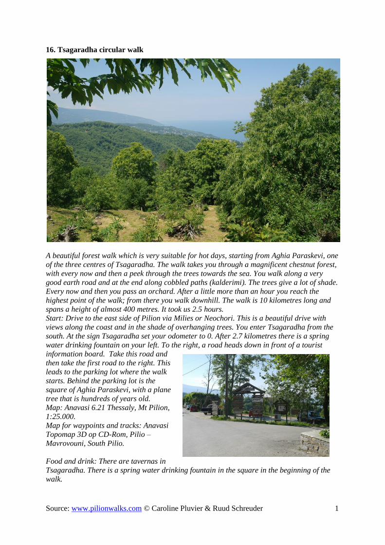
16. Tsagaradha circular walk
A beautiful forest walk which is very suitable for hot days, starting from Aghia Paraskevi, one
of the three centres of Tsagaradha. The walk takes you through a magnificent chestnut forest,
with every now and then a peek through the trees towards the sea. You walk along a very
good earth road and at the end along cobbled paths (kalderimi). The trees give a lot of shade.
Every now and then you pass an orchard. After a little more than an hour you reach the
highest point of the walk; from there you walk downhill. The walk is 10 kilometres long and
spans a height of almost 400 metres. It took us 2.5 hours.
Start: Drive to the east side of Pilion via Milies or Neochori. This is a beautiful drive with
views along the coast and in the shade of overhanging trees. You enter Tsagaradha from the
south. At the sign Tsagaradha set your odometer to 0. After 2.7 kilometres there is a spring
water drinking fountain on your left. To the right, a road heads down in front of a tourist
information board. Take this road and
then take the first road to the right. This
leads to the parking lot where the walk
starts. Behind the parking lot is the
square of Aghia Paraskevi, with a plane
tree that is hundreds of years old.
Map: Anavasi 6.21 Thessaly, Mt Pilion,
1:25.000.
Map for waypoints and tracks: Anavasi
Topomap 3D op CD-Rom, Pilio –
Mavrovouni, South Pilio.
Food and drink: There are tavernas in
Tsagaradha. There is a spring water drinking fountain in the square in the beginning of the
walk.

Source: www.pilionwalks.com © Caroline Pluvier & Ruud Schreuder 2
1. From the parking lot walk back to the road.
2. Turn up to the left.
3. 30 metres further on you turn left onto a kalderimi.
4. 80 metres higher up, where the kalderimi bends to the right, you pass a shop and walk
up steps to the road.
5. At the asphalt road turn right. There is a spring water drinking fountain on the other
side of the road. You walk past a supermarket.
6. After a bend a concrete road heads up to the left. Take this road. You walk into a
forest. Follow the concrete road up. Walk past Hotel 12. After this hotel the concrete
road changes into an earth road. Ignore a path to the left and further on an earth road to
the right and continue walking up along the earth road.
7. At an earth road up to the right you continue walking straight on round a bend to the
left. The earth road descends a little and then immediately heads up again. You pass in
succession a sign reading
ΑΓΙΟΣ ΑΘΑΝΑΣΙΟΣ, a
transmission tower and a
small concrete building. The
earth road continues
ascending.
8. After 30-40 minutes you
reach a wooden resting place
with benches. There is a sign
towards the chapel of ΑΓΙΟΣ
ΑΘΑΝΑΣΙΟΣ that lies 150
metres further on. To go there
take the left hand path.
9. At ΑΓΙΟΣ ΑΘΑΝΑΣΙΟΣ
there are picnic tables and another spring water drinking fountain. This is the highest
point of the walk.
Walk back to point 8 and head
down to the left. Ignore an earth
road up to the right and continue
walking down along the earth road.
Ignore all side paths. You pass a
concrete water tank on your left
hand side and later on a second
much larger one.
10. Further on a path leads to
the chapel of ΠΡΟΦΗΤΗ ΗΛΙΑ.
Ignore this path and continue
walking down. Further on you pass
a few houses.
11. At a house at a bend in a
concrete road you head down to the left. Further down ignore a path to the left.
12. You reach an asphalt road. Turn right here.
13. 50 metres further on a kalderimi heads down to the left. On a sign is painted ΑΓ.
ΠΑΡΑΣΚΕΥΗΣ (1914). The kalderimi narrows into an overgrown path and further
down once again becomes a beautiful kalderimi.
14. At a junction, head down to the right and at the next junction head down to the right
once again.

Source: www.pilionwalks.com © Caroline Pluvier & Ruud Schreuder 3
15. At a wire netting fence with poles
painted red and black, and a wooden
pole with a sign (to ΑΓ
ΠΑΡΑΣΚΕΥΗΣ and ΑΓ
ΠΑΝΤΕΛΕΗΜΟΝΟΣ) a narrow
path heads down to the left. Take
this path.
16. You reach a kalderimi, turn right
here. A red arrow also points in that
direction. Further on ignore a
kalderimi heading downwards and
follow the red arrow.
17. At an asphalt road cross over to the left and 20 metres further on take a path down to
the right. You descend to a river bed, which you cross along a concrete bridge. From
there you walk up again. You pass a church. At the asphalt road walk up to the left.
18. At a large building walk in front of the building towards a stone path at the other side.
You pass the Lost Unicorn hotel and walk further on to the square with its old plane
tree.
19. On the right hand side of the church walk up steps towards the parking lot.
Enjoyed your walk? Any comments? Let us know! [email protected]