Embed Size (px)
Citation preview
LAND FOR SALE Serving America’s Landowners Since 1929
L-1600375
Real Estate Sales • Auctions • Farm and Ranch Management • Appraisals • Insurance • Consultations Oil and Gas Management • Lake Management • Forest Resource Management • National Hunting Leases • FNC Ag Stock
Scott Huether, AgentLisbon, North DakotaPhone: (701) [email protected]/ScottHuether
For additional information, please contact:
www.FarmersNational.com
Irrigated Farm1,520+/- Acres • McPherson County, South DakotaSelling in Six Individual Tracts or as a Total Unit
Offered at $7,990,000
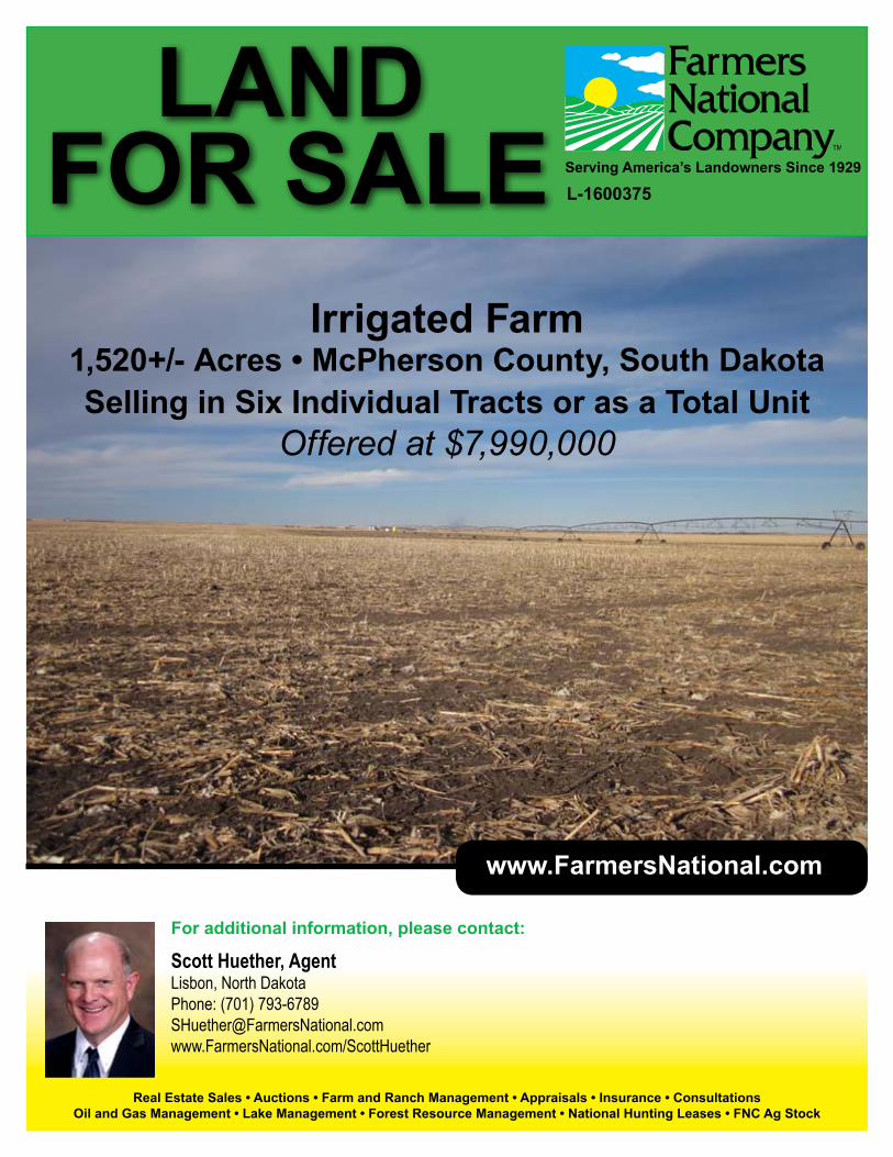
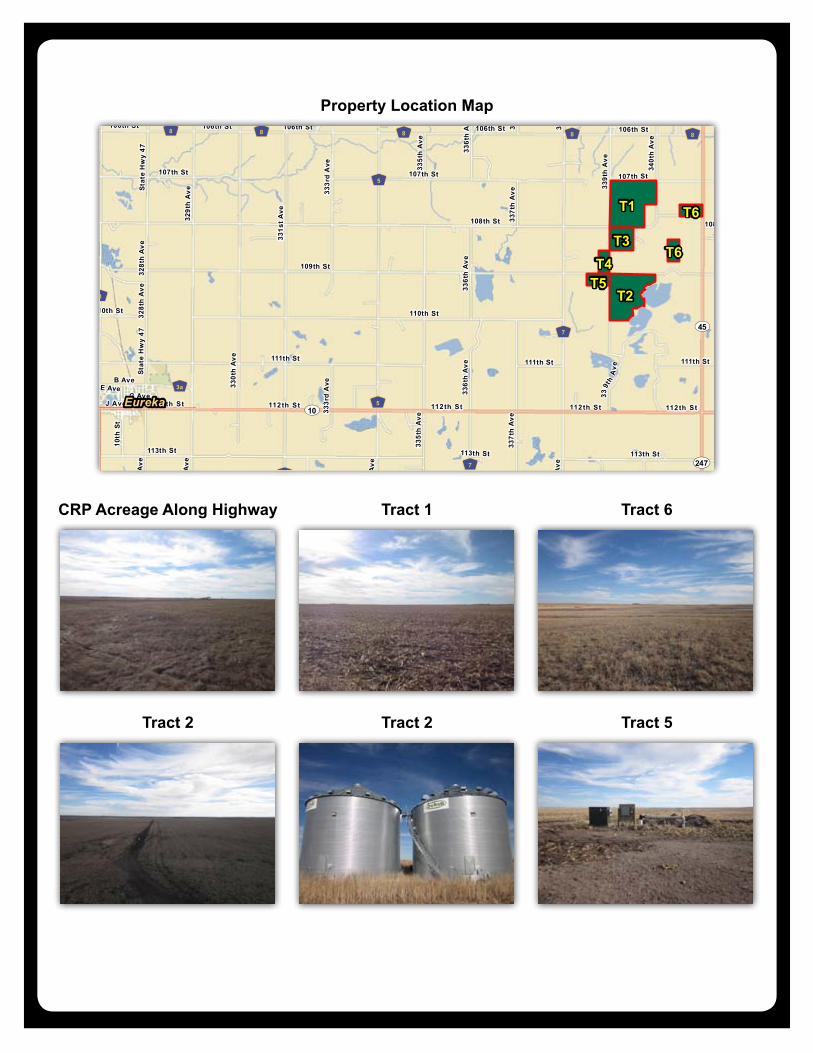
Property Location: From Eureka, South Dakota Junction of Highway 10 and Highway 47, nine miles east on Highway 10, three miles north on 338th Av-enue and one mile east on 109th Street; or from the intersection of Highway 45 and Highway 10, three miles north on Highway 45 and two miles west on 109th Street.
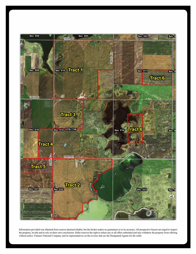
Legal Description: All in the Odessa Township • Tract 1: W1/2, W1/2 of SE1/4, NE1/4, all in Section 10, T-127N, R-71W, McPherson County, South Dakota • Tract 2: W1/2 including Lot 1, Neuharth First addition in McPherson County, South Dakota as shown in Plat No. 241, N1/2 of NE1/4, SW1/4 of NE1/4, NW1/4 of SE1/4, all in Section 22, T-127N, R-71W McPherson County, South Dakota• Tract 3: NW1/4 of Section 15, T-127N, R-71W, McPherson County, South Dakota• Tract 4: E1/2 of SE1/4 Section 16, T-127N, R-71W, McPherson County, South Dakota• Tract 5: N1/2 of NE1/4 Section 21, T-127N, R-71W, McPherson County, South Dakota• Tract 6: SE1/4 of NW1/4, NE1/4 of SW1/4 Section 14, T-127N, ,R-71W, and N1/2 of SE1/4 Section 11, T-127N, R-71W, McPherson County, South Dakota
Property Description: 1,520+/- acres Odessa Township, McPherson County, South Dakota ir-rigated farm. This farm consists of a contiguous tract containing 1,379.1 cropland acres, with 12 center pivot irrigators with 13 wells, covering 1,150 acres (per 2015 South Dakota Water Management Board acreage reports), 79.5 acres in CRP, bal-ance of land being dry land or non crop acres. This farm provides both excellent irrigated crop land, and excellent upland bird and waterfowl habitat on the non cropped acres. This farm is located within a half mile of a paved road with the CRP bordering this road. This farm also borders huntable game, fish, and waterfowl production areas. Current owner is willing to lease back.
Improvements: Two 25,000 bushel grain bins with full floor air, three additional 3,000 to 4000 bushel bins.
CRP: Tract 6 currently has 79.5+/- acres enrolled in the CRP program, due to expire in September 2020. Annual payment of $41.99 per acre.
Farm Data:• Tract 1Cropland 549.0 acresOther 11.0 acresTotal 560.0 acres• Tract 2Cropland 436.7 acresOther 43.3 acresTotal 480.0 acres• Tract 3Cropland 156.6 acresOther 3.4 acresTotal 160.0 acres• Tract 4Cropland 78.5 acresOther 1.5 acresTotal 80.0 acres• Tract 5Cropland 78.5 acresOther 1.5 acresTotal 80.0 acres• Tract 6CRP 79.5 acresOther 80.5 acres
FSA Information:• Tract 1,4,5 Base YieldWheat 23 acres 43 bushelsCorn 230 acres 132 bushelsSoybeans 96 acres 29 bushels• Tract 2 Base YieldWheat 27 acres 43 bushelsCorn 268 acres 132 bushelsSoybeans 112 acres 29 bushels• Tract 3 Base YieldWheat 23 acres 43 bushelsCorn 87 acres 132 bushelsSoybeans 36 acres 29 bushels
Taxes:• Tract 1: $3,428.26 or $6.12 per acre• Tract 2: $3,315.22 or $6.93 per acres• Tract 3: $913.96 or $5.71 per acre• Tract 4: $505.58 or $6.32 per acre• Tract 5: $522.32 or $6.53 per acre• Tract 6: $657.12 or $4.11 per acre
Property Information
Tract 1
Tract 3
127N 71W
Sec. 010
Sec. 003
Sec. 015
Sec. 009Sec. 011
Sec. 004
Sec. 016
Sec. 002
Sec. 014
339t
h A
ve
107th St
108th St
340t
h A
ve
Latitude: 45.8322°NLongitude: -99.3969°WImagery Source: USDA NAIP Soil Data Source: USDA NRCSBoundaries Are Approximate
Vculek FarmMcPherson Co., SD
Tract 2
Tract 5
Tract 4
127N 71WSec. 022
Sec. 015
Sec. 027
Sec. 021Sec. 023
Sec. 016
Sec. 028 Sec. 026
Sec. 014
109th St
339t
h A
ve
Latitude: 45.8031°NLongitude: -99.3970°WImagery Source: USDA NAIP Soil Data Source: USDA NRCSBoundaries Are Approximate
Vculek FarmMcPherson Co., SD
C817B
C878C
C878C
C829A
C810B
C004A
C004A
C877B
C816A
C005A
C003A
C004AC810A
Tract 1
Tract 3
127N 71W Sec. 010Sec. 009 Sec. 011
Sec. 003
Sec. 015
Sec. 002Sec. 004
Sec. 016 Sec. 014
107th St
108th St
339t
h A
ve
340t
h A
ve
Latitude: 45.8322°NLongitude: -99.3969°WImagery Source: USDA NAIP Soil Data Source: USDA NRCSBoundaries Are Approximate
Vculek FarmMcPherson Co., SD
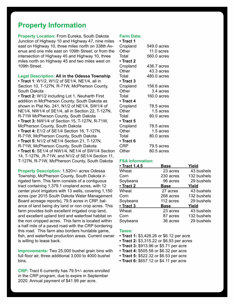
MAP NON IRR USDA SDSYMBOL NAME LCC PI PI ACRESC817B Lehr-Bowdle loams, 2 to 6 percent slopes IIIe 50 36 475.2C878C Wabek-Bowdle complex, 2 to 9 percent slopes VIs 42 30 61.9C829A Marysland loam, 0 to 1 percent slopes IVw 37 26 9.2C004A Tonka-Nishon silt loams, 0 to 1 percent slopes IVw 47 33 6.9C810B Bowdle loam, 2 to 6 percent slopes IIIe 54 38 6.6C877B Wabek-Lehr complex, 2 to 6 percent slopes VIs 39 28 2.4C816A Lehr loam, 0 to 2 percent slopes IIIs 47 33 2.2C005A Southam silty clay loam, 0 to 1 percent slopes VIIIw 5 4 2.1C003A Parnell silty clay loam, 0 to 1 percent slopes Vw 20 14 1.4C810A Bowdle loam, 0 to 2 percent slopes IIIs 57 40 0.1TOTAL 48.6 35.0 568.0
C816A
C810A
C816B
C810A
C816B
C810A
C877B
C817B
C877BC817B
C829A
C877B
C877B
C005A
C005A
Tract 2
Tract 5
Tract 4
127N 71WSec. 022
Sec. 021
Sec. 023
Sec. 015
Sec. 027Sec. 028
Sec. 014
Sec. 026
Sec. 016 109th St
339t
h A
ve
Latitude: 45.8031°NLongitude: -99.3970°WImagery Source: USDA NAIP Soil Data Source: USDA NRCSBoundaries Are Approximate
Vculek FarmMcPherson Co., SD
MAP NON IRR USDA SDSYMBOL NAME LCC PI PI ACRESC816A Lehr loam, 0 to 2 percent slopes IIIs 47 33 210.2C810A Bowdle loam, 0 to 2 percent slopes IIIs 57 40 179.9C816B Lehr loam, 2 to 6 percent slopes IIIe 44 31 56.1C877B Wabek-Lehr complex, 2 to 6 percent slopes VIs 39 28 7.3C817B Lehr-Bowdle loams, 2 to 6 percent slopes IIIe 50 36 4.3C829A Marysland loam, 0 to 1 percent slopes IVw 37 26 0.9C005A Southam silty clay loam, 0 to 1 percent slopes VIIIw 5 4 0.4TOTAL 50.4 35.4 459.0
C817B
C878C
C878C
C829A
C810B
C004A
C004A
C877B
C816A
C005A
C003A
C004AC810A
Tract 1
Tract 3
127N 71W Sec. 010Sec. 009 Sec. 011
Sec. 003
Sec. 015
Sec. 002Sec. 004
Sec. 016 Sec. 014
107th St
108th St
339t
h A
ve
340t
h A
ve
Latitude: 45.8322°NLongitude: -99.3969°WImagery Source: USDA NAIP Soil Data Source: USDA NRCSBoundaries Are Approximate
Vculek FarmMcPherson Co., SD
MAP NON IRR USDA SDSYMBOL NAME LCC PI PI ACRESC817B Lehr-Bowdle loams, 2 to 6 percent slopes IIIe 50 36 475.2C878C Wabek-Bowdle complex, 2 to 9 percent slopes VIs 42 30 61.9C829A Marysland loam, 0 to 1 percent slopes IVw 37 26 9.2C004A Tonka-Nishon silt loams, 0 to 1 percent slopes IVw 47 33 6.9C810B Bowdle loam, 2 to 6 percent slopes IIIe 54 38 6.6C877B Wabek-Lehr complex, 2 to 6 percent slopes VIs 39 28 2.4C816A Lehr loam, 0 to 2 percent slopes IIIs 47 33 2.2C005A Southam silty clay loam, 0 to 1 percent slopes VIIIw 5 4 2.1C003A Parnell silty clay loam, 0 to 1 percent slopes Vw 20 14 1.4C810A Bowdle loam, 0 to 2 percent slopes IIIs 57 40 0.1TOTAL 48.6 35.0 568.0
C816A
C810A
C816B
C810A
C816B
C810A
C877B
C817B
C877BC817B
C829A
C877B
C877B
C005A
C005A
Tract 2
Tract 5
Tract 4
127N 71WSec. 022
Sec. 021
Sec. 023
Sec. 015
Sec. 027Sec. 028
Sec. 014
Sec. 026
Sec. 016 109th St
339t
h A
ve
Latitude: 45.8031°NLongitude: -99.3970°WImagery Source: USDA NAIP Soil Data Source: USDA NRCSBoundaries Are Approximate
Vculek FarmMcPherson Co., SD
MAP NON IRR USDA SDSYMBOL NAME LCC PI PI ACRESC816A Lehr loam, 0 to 2 percent slopes IIIs 47 33 210.2C810A Bowdle loam, 0 to 2 percent slopes IIIs 57 40 179.9C816B Lehr loam, 2 to 6 percent slopes IIIe 44 31 56.1C877B Wabek-Lehr complex, 2 to 6 percent slopes VIs 39 28 7.3C817B Lehr-Bowdle loams, 2 to 6 percent slopes IIIe 50 36 4.3C829A Marysland loam, 0 to 1 percent slopes IVw 37 26 0.9C005A Southam silty clay loam, 0 to 1 percent slopes VIIIw 5 4 0.4TOTAL 50.4 35.4 459.0
Tract 1 Aerial Photo
Tract 2 Aerial Photo
Tract 1 Soil Map
Tract 2 Soil Map
Tract 3
Tract 1
Tract 4
127N 71W
Sec. 015
Sec. 010
Sec. 016
Sec. 009
108th St
339t
h A
ve
Latitude: 45.8213°NLongitude: -99.4022°WImagery Source: USDA NAIP Soil Data Source: USDA NRCSBoundaries Are Approximate
Vculek FarmMcPherson Co., SD
Tract 4
Tract 5
Tract 3
Tract 2
127N 71W
Sec. 016 Sec. 015
Sec. 021 Sec. 022
109th St
339t
h A
ve
Latitude: 45.8140°NLongitude: -99.4100°WImagery Source: USDA NAIP Soil Data Source: USDA NRCSBoundaries Are Approximate
Vculek FarmMcPherson Co., SD
C817B
C816A
C816A
C829A
C825A
C825A
Tract 4
Tract 5
Tract 3
Tract 2
127N 71W
Sec. 016 Sec. 015
Sec. 021 Sec. 022
109th St
339t
h A
ve
Latitude: 45.8140°NLongitude: -99.4100°WImagery Source: USDA NAIP Soil Data Source: USDA NRCSBoundaries Are Approximate
Vculek FarmMcPherson Co., SD
MAP NON IRR USDA SDSYMBOL NAME LCC PI PI ACRES
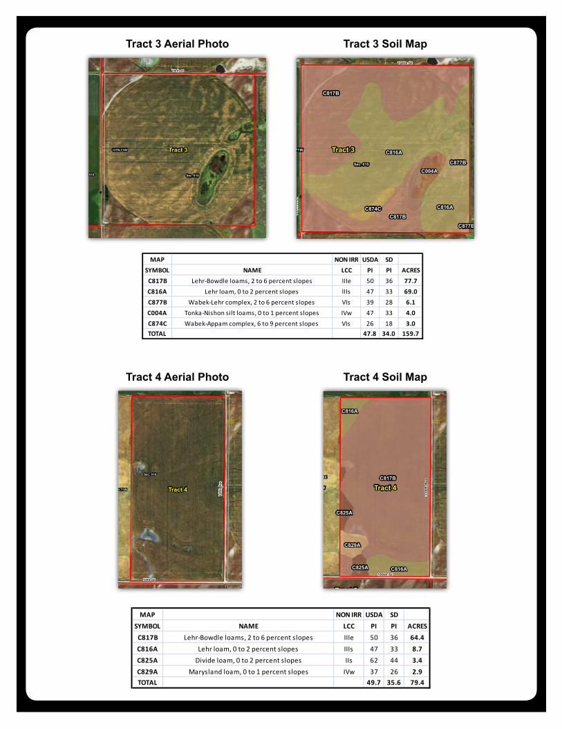
C817B Lehr-Bowdle loams, 2 to 6 percent slopes IIIe 50 36 64.4C816A Lehr loam, 0 to 2 percent slopes IIIs 47 33 8.7C825A Divide loam, 0 to 2 percent slopes IIs 62 44 3.4C829A Marysland loam, 0 to 1 percent slopes IVw 37 26 2.9TOTAL 49.7 35.6 79.4
C817B
C816A
C817B
C816A
C877BC004A
C874C
C877B
Tract 3
Tract 1
Tract 4
127N 71W
Sec. 015Sec. 016
Sec. 010Sec. 009
108th St
339t
h A
ve
Latitude: 45.8213°NLongitude: -99.4022°WImagery Source: USDA NAIP Soil Data Source: USDA NRCSBoundaries Are Approximate
Vculek FarmMcPherson Co., SD
MAP NON IRR USDA SDSYMBOL NAME LCC PI PI ACRES
C817B Lehr-Bowdle loams, 2 to 6 percent slopes IIIe 50 36 77.7C816A Lehr loam, 0 to 2 percent slopes IIIs 47 33 69.0C877B Wabek-Lehr complex, 2 to 6 percent slopes VIs 39 28 6.1C004A Tonka-Nishon silt loams, 0 to 1 percent slopes IVw 47 33 4.0C874C Wabek-Appam complex, 6 to 9 percent slopes VIs 26 18 3.0TOTAL 47.8 34.0 159.7
C817B
C816A
C817B
C816A
C877BC004A
C874C
C877B
Tract 3
Tract 1
Tract 4
127N 71W
Sec. 015Sec. 016
Sec. 010Sec. 009
108th St
339t
h A
ve
Latitude: 45.8213°NLongitude: -99.4022°WImagery Source: USDA NAIP Soil Data Source: USDA NRCSBoundaries Are Approximate
Vculek FarmMcPherson Co., SD
MAP NON IRR USDA SDSYMBOL NAME LCC PI PI ACRES
C817B Lehr-Bowdle loams, 2 to 6 percent slopes IIIe 50 36 77.7C816A Lehr loam, 0 to 2 percent slopes IIIs 47 33 69.0C877B Wabek-Lehr complex, 2 to 6 percent slopes VIs 39 28 6.1C004A Tonka-Nishon silt loams, 0 to 1 percent slopes IVw 47 33 4.0C874C Wabek-Appam complex, 6 to 9 percent slopes VIs 26 18 3.0TOTAL 47.8 34.0 159.7
C817B
C816A
C816A
C829A
C825A
C825A
Tract 4
Tract 5
Tract 3
Tract 2
127N 71W
Sec. 016 Sec. 015
Sec. 021 Sec. 022
109th St
339t
h A
ve
Latitude: 45.8140°NLongitude: -99.4100°WImagery Source: USDA NAIP Soil Data Source: USDA NRCSBoundaries Are Approximate
Vculek FarmMcPherson Co., SD
MAP NON IRR USDA SDSYMBOL NAME LCC PI PI ACRES
C817B Lehr-Bowdle loams, 2 to 6 percent slopes IIIe 50 36 64.4C816A Lehr loam, 0 to 2 percent slopes IIIs 47 33 8.7C825A Divide loam, 0 to 2 percent slopes IIs 62 44 3.4C829A Marysland loam, 0 to 1 percent slopes IVw 37 26 2.9TOTAL 49.7 35.6 79.4
Tract 3 Aerial Photo
Tract 4 Aerial Photo
Tract 3 Soil Map
Tract 4 Soil Map
Tract 5
Tract 4
Tract 2
127N 71W
Sec. 021
Sec. 016
Sec. 022
Sec. 015
109th St 339t
h A
ve
Latitude: 45.8086°NLongitude: -99.4125°WImagery Source: USDA NAIP Soil Data Source: USDA NRCSBoundaries Are Approximate
Vculek FarmMcPherson Co., SD
C817B
C825A
C816AC817B
C810A
C877B
Tract 5
Tract 4
Tract 2
127N 71W
Sec. 021
Sec. 016
Sec. 022
Sec. 015
109th St
339t
h A
ve
Latitude: 45.8086°NLongitude: -99.4125°WImagery Source: USDA NAIP Soil Data Source: USDA NRCSBoundaries Are Approximate
Vculek FarmMcPherson Co., SD
MAP NON IRR USDA SDSYMBOL NAME LCC PI PI ACRES
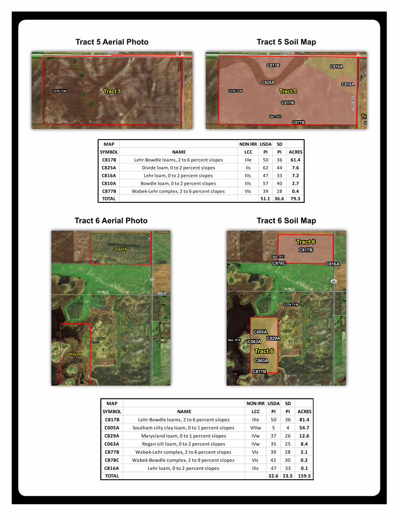
C817B Lehr-Bowdle loams, 2 to 6 percent slopes IIIe 50 36 61.4C825A Divide loam, 0 to 2 percent slopes IIs 62 44 7.6C816A Lehr loam, 0 to 2 percent slopes IIIs 47 33 7.2C810A Bowdle loam, 0 to 2 percent slopes IIIs 57 40 2.7C877B Wabek-Lehr complex, 2 to 6 percent slopes VIs 39 28 0.4TOTAL 51.1 36.6 79.3
Tract 6
Tract 6
127N 71W
Sec. 014
Sec. 011
Sec. 013
Sec. 012
108th St
ST45
Latitude: 45.8232°NLongitude: -99.3737°WImagery Source: USDA NAIP Soil Data Source: USDA NRCSBoundaries Are Approximate
Vculek FarmMcPherson Co., SD
C817B
C005AC829A
C063A
C063A
C877B
C878C C816A
Tract 6
Tract 6
Tract 1
127N 71W
Sec. 014
Sec. 011
Sec. 013
Sec. 012
Sec. 015
Sec. 010
108th St
340t
h A
ve
108th St
ST45
Latitude: 45.8232°NLongitude: -99.3737°WImagery Source: USDA NAIP Soil Data Source: USDA NRCSBoundaries Are Approximate
Vculek FarmMcPherson Co., SD
MAP NON IRR USDA SDSYMBOL NAME LCC PI PI ACRESC817B Lehr-Bowdle loams, 2 to 6 percent slopes IIIe 50 36 81.4C005A Southam silty clay loam, 0 to 1 percent slopes VIIIw 5 4 54.7C829A Marysland loam, 0 to 1 percent slopes IVw 37 26 12.6C063A Regan silt loam, 0 to 2 percent slopes IVw 35 25 8.4C877B Wabek-Lehr complex, 2 to 6 percent slopes VIs 39 28 2.1C878C Wabek-Bowdle complex, 2 to 9 percent slopes VIs 42 30 0.2C816A Lehr loam, 0 to 2 percent slopes IIIs 47 33 0.1TOTAL 32.6 23.5 159.5
C817B
C825A
C816AC817B
C810A
C877B
Tract 5
Tract 4
Tract 2
127N 71W
Sec. 021
Sec. 016
Sec. 022
Sec. 015
109th St
339t
h A
ve
Latitude: 45.8086°NLongitude: -99.4125°WImagery Source: USDA NAIP Soil Data Source: USDA NRCSBoundaries Are Approximate
Vculek FarmMcPherson Co., SD
MAP NON IRR USDA SDSYMBOL NAME LCC PI PI ACRES
C817B Lehr-Bowdle loams, 2 to 6 percent slopes IIIe 50 36 61.4C825A Divide loam, 0 to 2 percent slopes IIs 62 44 7.6C816A Lehr loam, 0 to 2 percent slopes IIIs 47 33 7.2C810A Bowdle loam, 0 to 2 percent slopes IIIs 57 40 2.7C877B Wabek-Lehr complex, 2 to 6 percent slopes VIs 39 28 0.4TOTAL 51.1 36.6 79.3
C817B
C005AC829A
C063A
C063A
C877B
C878C C816A
Tract 6
Tract 6
Tract 1
127N 71W
Sec. 014
Sec. 011
Sec. 013
Sec. 012
Sec. 015
Sec. 010
108th St
340t
h A
ve
108th St
ST45
Latitude: 45.8232°NLongitude: -99.3737°WImagery Source: USDA NAIP Soil Data Source: USDA NRCSBoundaries Are Approximate
Vculek FarmMcPherson Co., SD
MAP NON IRR USDA SDSYMBOL NAME LCC PI PI ACRES
C817B Lehr-Bowdle loams, 2 to 6 percent slopes IIIe 50 36 81.4C005A Southam silty clay loam, 0 to 1 percent slopes VIIIw 5 4 54.7C829A Marysland loam, 0 to 1 percent slopes IVw 37 26 12.6C063A Regan silt loam, 0 to 2 percent slopes IVw 35 25 8.4C877B Wabek-Lehr complex, 2 to 6 percent slopes VIs 39 28 2.1C878C Wabek-Bowdle complex, 2 to 9 percent slopes VIs 42 30 0.2C816A Lehr loam, 0 to 2 percent slopes IIIs 47 33 0.1TOTAL 32.6 23.5 159.5
Tract 5 Aerial Photo
Tract 6 Aerial Photo
Tract 5 Soil Map
Tract 6 Soil Map
T1
T2
T3
T6
T4T5
T6
112th StJ Ave
341s
tA
ve
112 th St112th St112th St 112th St
109th St
108th St
110th St
111th St
113th St
330t
h A
ve
331s
t Ave
335t
h A
ve
107th St
329t
h A
ve
339t
h A
ve
337t
h A
ve
333r
d A
ve
114th St
328t
h A
ve
334t
h A
ve
338t
h A
ve
340t
h A
ve
Stat
e H
wy
47 336t
h A
ve
327t
h A
ve
B Ave
106th St10
th S
t
G AveE Ave
108th St
106th St
336t
h A
ve
111th St
336t
h A
ve
328t
h A
ve
113th St
106th St
328t
h A
ve
336t
h A
ve
339t
hA
ve
333r
d A
ve
338t
h A
ve
107th St
337t
h A
ve
114th St
335t
h A
ve
330t
h A
ve
Stat
e H
wy
47106th St
113th St
106th St
107th St
111th St
333r
d A
ve
114th St
110th St
327t
h A
ve
329t
h A
ve
337t
h A
ve
114th St
Eureka
GG5
GG7
GG8
GG3
GG3a
GG7
GG8
GG5
GG8 GG8 GG8
GG5
ST45
ST47
ST10
ST247
Latitude: 45.7972°NLongitude: -99.4975°WImagery Source: USDA NAIP Soil Data Source: USDA NRCSBoundaries Are Approximate
Vculek FarmMcPherson Co., SD
Property Location Map
CRP Acreage Along Highway Tract 1
Tract 2
Tract 6
Tract 2 Tract 5
Tract 1
Tract 2
Tract 3
Tract 6
Tract 5
Tract 4
Tract 6127N 71W
Sec. 010
Sec. 015
Sec. 022 Sec. 023
Sec. 011
Sec. 014
Sec. 009
Sec. 016
Sec. 021
Sec. 002Sec. 003
Sec. 027 Sec. 026
Sec. 004
Sec. 028
Sec. 024
Sec. 013
Sec. 012
Sec. 001
Sec. 025
109th St
339t
h A
ve
107th St
108th St
340t
h A
ve
ST45
Latitude: 45.8177°NLongitude: -99.3919°WImagery Source: USDA NAIP Soil Data Source: USDA NRCSBoundaries Are Approximate
Vculek FarmMcPherson Co., SD
Information provided was obtained from sources deemed reliable, but the broker makes no guarantees as to its accuracy. All prospective buyers are urged to inspect the property, its title and to rely on their own conclusions. Seller reserves the right to refuse any or all offers submitted and may withdraw the property from offering without notice. Farmers National Company and its representatives on the reverse side are the Designated Agents for the seller.


![[XLS] · Web viewNuA - NUNN CLAY LOAM, 0 TO 2 PERCENT SLOPES NuB - NUNN CLAY LOAM, 2 TO 6 PERCENT SLOPES NuC - NUNN CLAY LOAM, 6 TO 9 PERCENT SLOPES Hw - HOVEN SILT LOAM, PONDED,](https://img.pdfslide.us/doc/110x75/5c04438409d3f2183a8b6d2b/xls-web-viewnua-nunn-clay-loam-0-to-2-percent-slopes-nub-nunn-clay-loam.jpg)


![[XLS]efotg.sc.egov.usda.gov · Web viewMATHIAS-MIDWAY-ROCK OUTCROP COMPLEX, 15 TO 30 PERCENT SLOPES MnF MATHIAS-ROCKOA-ROCK OUTCROP COMPLEX, 25 TO 60 PERCENT SLOPES MINNEQUA SILT](https://img.pdfslide.us/doc/110x75/5c04438409d3f2183a8b6d2c/xlsefotgscegovusdagov-web-viewmathias-midway-rock-outcrop-complex-15.jpg)