Embed Size (px)
Citation preview

15 August 2007 Peru tsunami runup and
inundation
Hermann M. Fritz1, Nikos Kalligeris2, Erick Ortega3, and Pablo Broncano3
1 School of Civil and Environmental Engineering, Georgia Institute of Technology, Savannah, GA 31407, USA, [email protected]
2 Department of Environmental Engineering, Technical University of Crete, Chanea 73100, Greece, [email protected]
3 Dirección de Hydrografía y Navegación, Marina de Guerra, Callao, Peru, [email protected]
On August 15, 2007 at 23:40:57 UTC (local time: UTC-5), a magnitude Ms 8.0
earthquake occurred 35 km west off the beaches near Chincha Alta at Peru’s central
coastline. First reports focused entirely on the earthquake damage and the resulting more
than 500 fatalities, little became known about the subsequent tsunami. It was not until the
GEER team that surveyed the geotechnical effects a week after the event recommended a
dedicated tsunami survey team be formed to investigate the collateral tsunami impact.
This example illustrates the interplay of various reconnaissance teams calling upon each
other dependent on their initial observations. Upon arrival in Lima on September 3 the
tsunami survey was coordinated through the Peruvian Navy, which operates various tide
gauges and reports to the Pacific Tsunami Warning Center (PTWC). Unfortunately the
closest tide gauge located only 55km south of the epicenter at the Puerto General San
Martin was damaged by the earthquake and remained unable to record the tsunami or its

arrival. Ironically it was the antique mechanical recording device that was knocked off
the table and neither the structure nor the pressure sensor itself that failed. It became
apparent that the Peruvian Navy’s central command was completely “blind” in the hours
after the event due to a loss of communication to the fine network of coast guard
outposts. Fortunately all the sergeants manning the countless outposts were alerted by the
earthquake and triggered spontaneous self-evacuations in the affected fishing villages in
the short time window of 10-20min between the earthquake and the onslaught of the
tsunami. The sergeant of Rancherio, a most remote outpost on the Bahia de la
Independencia, emphasized the need for reliable communication as the evacuees were
stuck on top of a sand dune for the night. Unfortunately not all the coastal residents
triggered a spontaneous-self evacuation. In Lagunilla on the south coast of the Paracas
Peninsula 3 out of the 7 inhabitants were washed away and their dead bodies recovered
up to 1.8 km inland. All of these deaths could have been prevented with high ground less
than 100m away as Lagunilla did not suffer significant earthquake damage if only the
residents were aware of the tsunami hazard after an earthquake and the mandatory
immediate self evacuation.
The International Tsunami Survey Team incurred 1000 km by off-road vehicle from
September 4 to 7. The tsunami reconnaissance surveyed more than 260km of Pacific
coastline from Lima to 50 km south of Paracas in the uninhabited desert. The team
measured local flow depths and tsunami heights, maximum runup, inundation distances,
recorded structural damage and interviewed eyewitnesses per established methods

[Synolakis and Okal, 2005]. Eyewitnesses described between one and four main waves
with an initial recession corresponding to a leading depression N-wave [Tadepalli and
Synolakis, 1996]. More than 50 transects were recorded from the waterline to the
inundation limit and adjusted for tide levels upon tsunami arrival. The tsunami run-up
distribution peaks south of the Paracas peninsula with a 10 m runup spike on Playa
Yumaque and sustained runup in excess of 7m along 5km of coastline. Fortunately the
tsunami impact peaked in a mostly uninhabited desert area. The nearest permanent
settlements are Rancherio and Lagunilla described previously as good and bad examples
of tsunami awareness. At Lagunilla the tsunami flooded up to 2km inland over extremely
flat terrain with 4m runup at the inundation limit and 5 to 6m runup heights at the village
on the shoreline. More than twenty boats were smashed ashore up to 1.3km inland.
Similar runup heights and flow depths during the 2004 Indian Ocean tsunami resulted in
much higher death tolls in Sri Lanka [Liu et al. 2005] and Somalia [Fritz and Borrero,
2006]. To the north of the Paracas peninsula the tsunami runup was roughly halved with
characteristic runup heights of 3m. Nevertheless boats were washed into the streets in
Pisco and the Tambo de Mora prison was partially flooded in Chincha Alta. Luckily the
prison compound walls collapsed due to the earthquake setting free 600 prisoners prior to
the onslaught of the tsunami. Similarly Indonesia’s super security prison on Nusa
Kambangan was inside the tsunami flood zone during the 17 July 2006 Java tsunami
earthquake [Fritz et al., 2007]. This Peru earthquake represents a unique opportunity to
characterize the collateral tsunami impact in the immediate aftermath of a destructive

earthquake. Community-based education and awareness programs are particularly
essential to help save lives in locales at risk from near-source tsunamis [Sieh, 2006]. A
tsunami education and awareness lecture was presented in Spanish at the Escuela Naval
del Peru (Peru’s Naval Academy) upon return to Lima. This is of particular importance
for Peru given the fairly frequent moderate size tsunamis such as the 2001 Camana
tsunami in southern Peru (Okal et al., 2002), the 1996 Chimbote tsunami in northern Peru
(Bourgeois et al., 1999) and a 1974 tsunami in the same area as the 2007 event.
Acknowledgments
The survey team was supported by the Earthquake Engineering Research Institute EERI
and the National Science Foundation through the NSF SGER-award CMS-0646278.
References
Bourgeois, J., C. Petroff, H. Yeh, V.V. Titov, C.E. Synolakis, B. Benson, J. Kuroiwa, J.
Lander, and E. Norabuena (1999), Geologic setting, field survey and modeling of
the Chimbote, northern Peru tsunami of 21 February 1996, Pure Appl. Geophys.
154, 513–540.
Fritz, H.M., W. Kongko, A. Moore, B. McAdoo, J. Goff, C. Harbitz, B. Uslu, N.
Kalligeris, D. Suteja, K. Kalsum, V. Titov, A. Gusman, H. Latief, E. Santoso, S.
Sujoko, D. Djulkarnaen, H. Sunendar, C. Synolakis (2007). Extreme runup from
the 17 July 2006 Java tsunami, Geophys. Res. Lett., 34, L12602,
doi:101029/2007GL029404.
Fritz, H.M., J.C. Borrero (2006). Somalia field survey of the 2004 Indian Ocean
Tsunami. Earthquake Spectra 22(S3):S219-S233.
Liu, P.L.-F., Lynett, P., Fernando, J., Jaffe, B.E., Fritz, H.M., Higman, B., Morton, R.,
Goff, J., and Synolakis, C.E., 2005. Observations by the International Tsunami
Survey Team in Sri Lanka, Science 308(5728):1595.
Okal, E. A., L. Dengler, S. Araya, J.C. Borrero, B. Gomer, S. Koshimura, G. Laos, D.
Olcese, M. Ortiz, M. Swensson, V.V. Titov, and F. Vegas (2002), A field survey
of the Camana, Peru tsunami of June 23, 2001, Seism. Res. Lett. 73, 904–917.
Sieh, K. (2006). Sumatran Megathrust Earthquakes - From Science to Saving Lives, Phil.
Trans. R. Soc. A 364(1845):1947-1963.
Synolakis, C.E., and E.A. Okal (2005). 1992-2002: Perspective on a decade of post-
tsunami surveys; in: Tsunamis: Case studies and recent developments, ed. by K.
Satake, Adv. Natur. Technol. Hazards, 23:1-30.
Tadepalli, S., C.E. Synolakis (1994). The Run-Up of N-Waves on Sloping Beaches.
Proceedings: Mathematical and Physical Sciences, 445(1923):99-112.
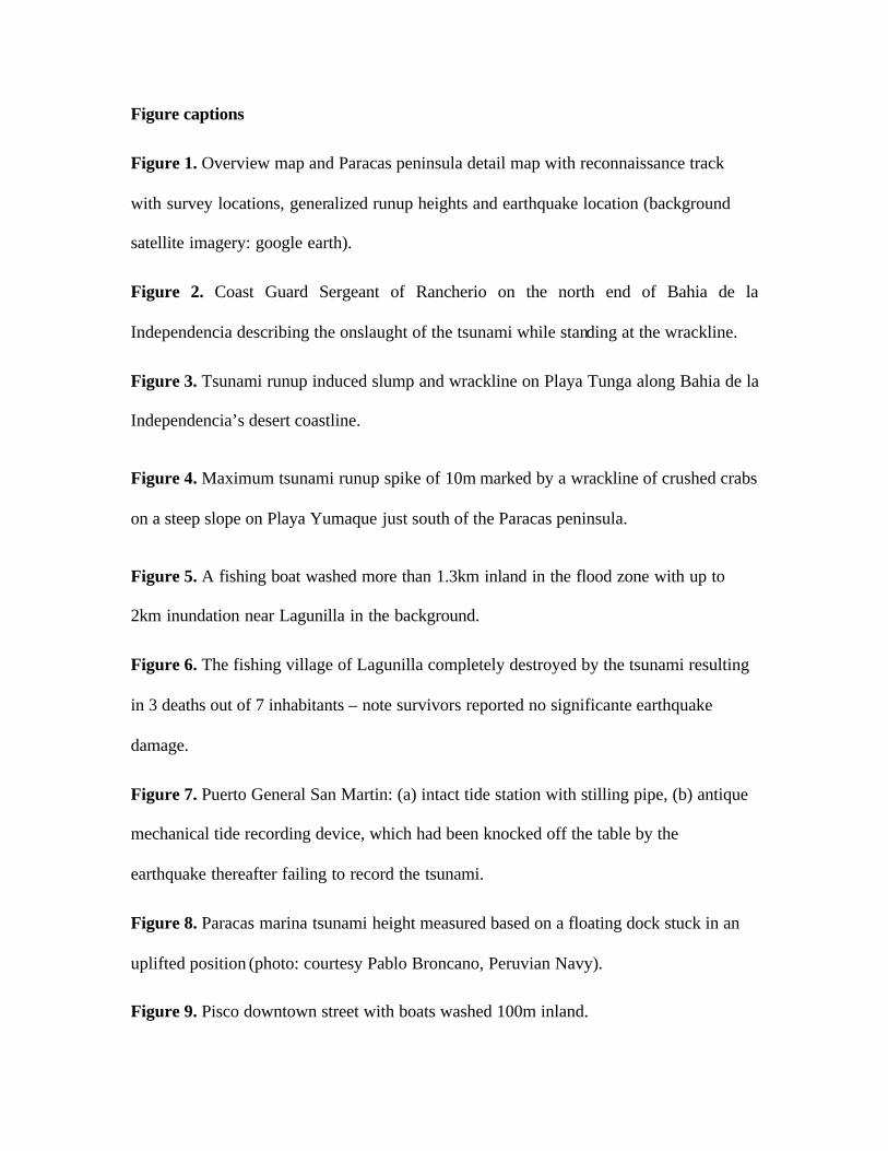
Figure captions
Figure 1. Overview map and Paracas peninsula detail map with reconnaissance track
with survey locations, generalized runup heights and earthquake location (background
satellite imagery: google earth).
Figure 2. Coast Guard Sergeant of Rancherio on the north end of Bahia de la
Independencia describing the onslaught of the tsunami while standing at the wrackline.
Figure 3. Tsunami runup induced slump and wrackline on Playa Tunga along Bahia de la
Independencia’s desert coastline.
Figure 4. Maximum tsunami runup spike of 10m marked by a wrackline of crushed crabs
on a steep slope on Playa Yumaque just south of the Paracas peninsula.
Figure 5. A fishing boat washed more than 1.3km inland in the flood zone with up to
2km inundation near Lagunilla in the background.
Figure 6. The fishing village of Lagunilla completely destroyed by the tsunami resulting
in 3 deaths out of 7 inhabitants – note survivors reported no significante earthquake
damage.
Figure 7. Puerto General San Martin: (a) intact tide station with stilling pipe, (b) antique
mechanical tide recording device, which had been knocked off the table by the
earthquake thereafter failing to record the tsunami.
Figure 8. Paracas marina tsunami height measured based on a floating dock stuck in an
uplifted position (photo: courtesy Pablo Broncano, Peruvian Navy).
Figure 9. Pisco downtown street with boats washed 100m inland.

Figure 10. Tsunami flow depth measurement based on a mudline inside a house in Pisco.
Figure 11. Tsunami inundation measurement based on salt-burn and trimline in corn
field near Chincha Alta.
Figure 12. Tambo de Mora prison near Chincha Alta with partially collapsed compound
walls due to the earthquake. Note the mudline on the white inside of the compound wall
indicating 1m flow depth.

Figure 1
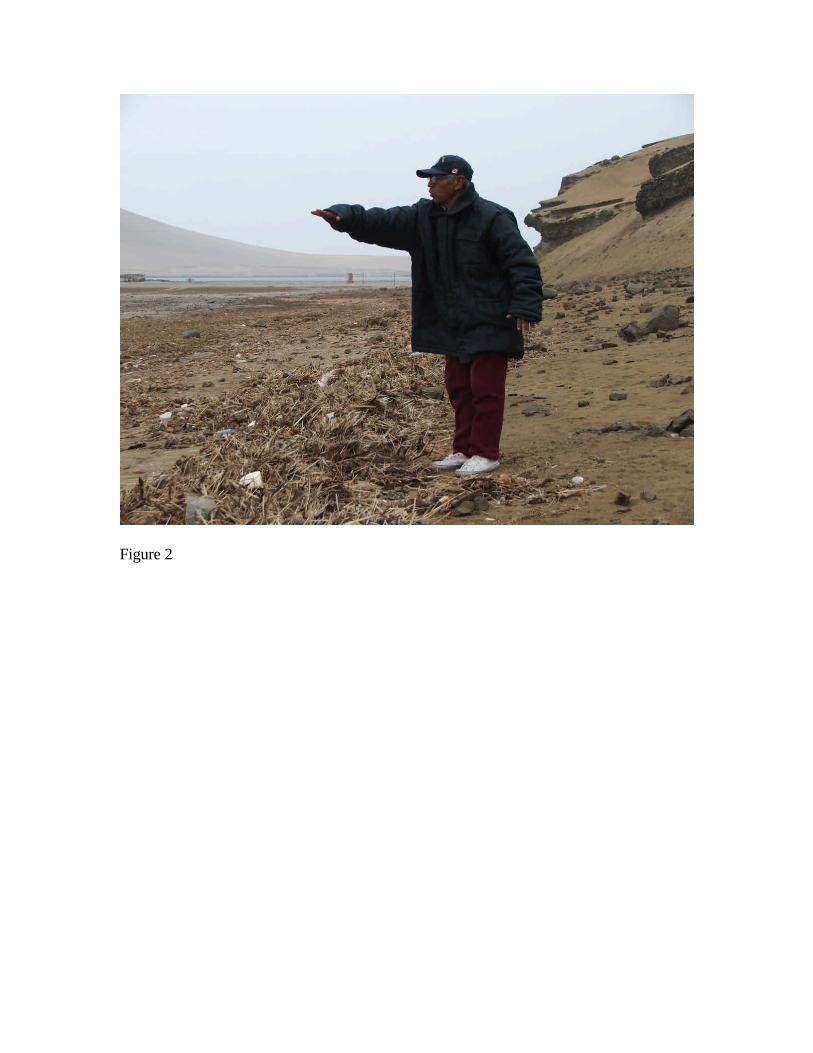
Figure 2
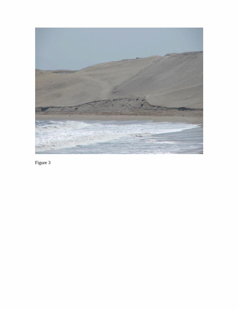
Figure 3
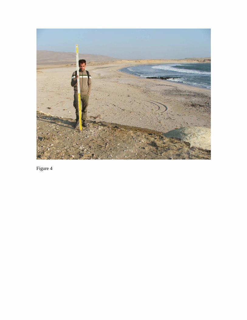
Figure 4

Figure 5

Figure 6

(a) (b)
Figure 7

Figure 8
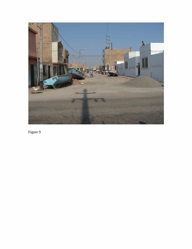
Figure 9

Figure 10

Figure 11
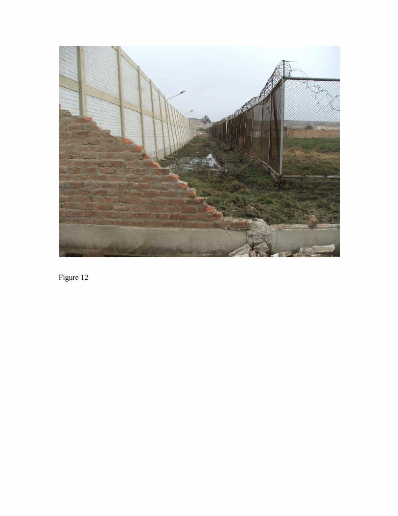
Figure 12