Embed Size (px)
Citation preview
Merced County 14-1 2030 Merced County General Plan November 2012 Draft PEIR
14 LAND USE
This chapter provides an evaluation of the potential land use effects from implementing the proposed 2030 Merced County General Plan (2030 General Plan). As established in the Notice of Preparation (see Appendix A, Notice of Preparation), urban development and other activities subject to the 2030 General Plan may result in conflicts with other land use plans that have jurisdiction within Merced County.
The following environmental evaluation includes a review of all land uses, programs, and policies potentially affected by the implementation of the 2030 General Plan. The evaluation is based on comparing existing land uses with the proposed conditions that may affect land uses or result in conflicting land uses upon implementation of total buildout under the 2030 General Plan.
This analysis also determines if the proposed 2030 General Plan is consistent with the following applicable regulations, requirements, plans and policies:
• Merced County General Plan (2000) • General Plan Law (California Government Code Section 65300) • Housing Element Law (California Government Code Section 65560, et seq.) • Safety Element Law (Government Code, Title 7, Sections 65302 (f) and 65302.1) • Specific Plan Law (California Government Code Section 65451). • Delhi Community Specific Plan (2006) • Fox Hills Community Specific Plan (2006) • Franklin/Beachwood Community Specific Plan (1983) • Hilmar Community Specific Plan (2008) • Le Grand Community Specific Plan (1983) • Planada Community Specific Plan (2003) • Santa Nella Community Specific Plan (2001) • University Community Plan (2004) • Villages of Laguna San Luis Community Plan (2008) • Winton Community Specific Plan (1981) • Merced County Zoning Code • California Zoning Law (Government Code Section 65860) • Cortese-Knox-Hertzberg Local Government Reorganization Act of 2000 (CKH Act)
(California Government Code Section 56000, et seq.) • City of Atwater General Plan (2000) • City of Dos Palos General Plan (1991) • City of Gustine General Plan (2002) • City of Livingston General Plan (1999) • City of Los Banos General Plan (2009) • City of Merced General Plan (2012) • University of California, Merced Long Range Development Plan (LRDP)

Land Use
2030 Merced County General Plan 14-2 Merced County Draft PEIR November 2012
• California Constitution, Article IX, Section 9 • UC Merced Long Range Development Plans - UCOP Facilities Manual • Fresno County General Plan (2000) • Mariposa County General Plan (2007) • Madera County General Plan (1995) • San Benito County General Plan (1995) • Santa Clara County General Plan (1994) • Stanislaus County General Plan (1994) • City of Chowchilla General Plan (2006) • City of Newman General Plan (1992) • City of Turlock General Plan (1993) • California Public Utilities Code, Sections 21670-21679.5 (Chapter 4, Article 3.5) • The Transportation Equity Act for the 21st Century (TEA-21) • Safe, Accountable, Flexible, Efficient Transportation Equity Act: A Legacy for Users
(SAFETEA-LU) • Merced County Association of Governments (MCAG) • Regional Housing Needs Plan (2001) • Federal Transportation Improvement Program (2006) • Merced County Short Range Transit Plan (2004) • Regional Transportation Plan (2011) • Merced County Airport Land Use Compatibility Plan (2012) • San Joaquin Valley Blueprint
Potential impacts that may result in land use conflicts were determined by comparing potential land use designations and project facilities that would be impacted or needed under the total buildout of the 2030 General Plan to the existing land uses based on CEQA assessment criteria. The proposed land use diagram is illustrated in Figure 14-1.
14.1 SETTING
The environmental and regulatory setting of Merced County with respect to land use is described in detail in the General Plan Background Report (Merced County 2007; updated 2012). That document is incorporated by reference into this Draft PEIR pursuant to State CEQA Guidelines Section 15150 as though fully set forth herein. The updated Background Report document is available for download from the Merced County General Plan website at:
http://www.co.merced.ca.us/index.aspx?NID=1926.
Copies of the Background Report may also be viewed during standard business hours (8:30 a.m. to 4:30 p.m.), Monday through Friday, at the Merced County Planning and Community Development Department, 2222 M Street, Merced, California 95340, and at the Main Branch of the Merced County Library located at 2100 O Street, Merced California 95340.

Merced County General Plan UpdateFigure 14-1
2030 Merced County General Plan Land Use DiagramSOURCE: Merced County, 2010

Land Use
2030 Merced County General Plan 14-4 Merced County Draft PEIR November 2012
14.1.1 ENVIRONMENTAL SETTING Unincorporated land within the county accounts for slightly over 1.2 million acres, or 96.7 percent of all land in the county. Incorporated cities account for 24,138 acres, or 1.9 percent. Agriculture is the predominate use in the county, totaling 1.16 to 1.17 million acres1, or 92 percent of the unincorporated county. Figure 14-2 illustrates the land use diagram set forth in the existing Merced County 2000 General Plan.
The Background Report’s discussion of the land use environmental setting is organized into the following categories:
• Residential Land. Residential land uses include single-family residential, multi-family residential, and mobile homes. Residential uses in unincorporated Merced County total approximately 16,070 parcels and cover 11,635 acres. Residential development in the county is concentrated along State Route (SR) 99 adjacent to existing cities and within unincorporated communities.
• Commercial, Industrial, Mining Land. Commercial uses include office, retail, and outdoor sale uses. Industrial uses include light industrial establishments, such as warehouses and storage businesses. Commercial uses represent 3,025 acres (0.2 percent), industrial uses represent 2,488 acres (0.2 percent), and mining uses represent 3,375 acres (0.3 percent) of land within the entire county.
• Public/Quasi Public Land. Public/Quasi Public uses include railroads, airports, cemeteries, hospitals, landfills, schools, public service facilities, and public utilities. It also includes state and federally managed lands such as wildlife refuges, wildlife management areas, and state parks. These land uses represent approximately 10.8 percent of the unincorporated county.
• Agricultural Land. Agricultural uses include row crops, orchards, grazing, poultry, and dairies. All agricultural uses combined account for 1.16 to 1.17 million acres in the county.
• Open Space, Vacant, and Other Land. Open Space uses include greenbelts and other dedicated open space. 57,305 acres of the unincorporated county, or 4.8 percent, is used for open space purposes.
The major findings of the Background Report with respect to land use are set forth below.
Existing Land Use
• Agricultural land use (including cultivated agriculture, grazing, dairy, and poultry) accounts for the largest existing land use in the county, with approximately 1.16 to 1.17 million acres (92 percent) within the county.
• The six incorporated cities in Merced County account for 24,138 acres or 1.9 percent of all land within the county.
1 Differing amounts of acreage depending upon the source: the Merced County Agricultural Commissioner (MCAC)
or the California Department of Conservation. For more information on this topic, please refer to Chapter 6, Agricultural and Forestry Resources, of this EIR.

Merced County General Plan UpdateFigure 14-2
2000 Merced County General Plan Land Use DiagramSOURCE: Merced County, 1990

Land Use
2030 Merced County General Plan 14-6 Merced County Draft PEIR November 2012
Merced County General Plan (2000)
• A major policy in the existing General Plan is the “Urban Centered Concept.” The concept directs new urbanization towards existing cities and community centers, and supports the creation of new urban centers only in limited circumstances. The urban centered concept is expressed through four area designations on the General Plan Diagram: Specific Urban Development Plan (SUDP), Rural Residential Center (RRC), Highway Interchange Center (HIC), and Agricultural Services Centers (ASC).
• The Agricultural Element contains policies for the preservation of farmland by allowing the conversion of farmland to urban uses only when a clear and immediate need can be demonstrated. The Agricultural Element also directs development to less valuable farmland when conversion is justified, and calls for land use transitions and buffers between urban and agricultural areas to reduce interference.
Merced County Zoning Code (2000)
• The Zoning Code establishes three agricultural zones, seven residential zones, five commercial zones, and two industrial zones.
Sphere of Influence
• Merced County LAFCO policies discourage the annexation of prime agricultural land when significant areas of non-prime agricultural land are already available. The policies also encourage the development of vacant areas within cities before the annexation and development of fringe areas.
• LAFCO policies encourage city annexations that reflect a planned, logical, and orderly progression of urban expansion and promote efficient delivery of urban services.
• Approximately 40,000 acres of unincorporated Merced County falls within the Sphere of Influence (SOI) of the six incorporated cities.
City General Plans
• The City of Los Banos adopted their updated 2030 General Plan in June 2009. The Los Banos 2030 General Plan focuses the majority of new growth to the northwest, west and south of the existing city. It considered a buildout population of 90,400 by 2030.
• The City of Livingston approved its 2025 General Plan in 2008, but the plan was repealed as a result of litigation. The 1999 General Plan is in force, and it contemplates a buildout population of 23,000 by 2020.
• The City of Merced adopted the Merced Vision 2030 General Plan on January 3, 2012. The updated 2030 General Plan anticipates a population of over 155,000 people.
• The City of Dos Palos, located in southwestern Merced County, adopted the 2010 General Plan in 1991; it anticipates 19,667 residents by 2010.
• The City of Gustine last updated its 2020 General Plan in 2002, which anticipates a buildout population of 8,000 residents.
• The City of Atwater updated its General Plan in 2000. The current 2000 General Plan anticipates a 20-year planning horizon and identifies the city’s holding capacity as approximately 44,000 acres with 64,000 residents.

Land Use
Merced County 14-7 2030 Merced County General Plan November 2012 Draft PEIR
Surrounding County/City General Plans
• The City of Chowchilla recently updated its 2040 General Plan, and the City of Turlock and the counties of Fresno, San Benito, and Madera are currently (2012) updating their General Plans. Merced County will need to coordinate planning efforts with these jurisdictions.
• Significant growth is likely to occur in the cities of Newman, Chowchilla, and Turlock, adjacent to the Merced County line.
University of California, Merced, Long Range Development Plan
• Development of the University of California, Merced will increase the demand for urban development on unincorporated land adjacent to the campus.
Regional Plans and Policies
• Each public airport in the county had their Airport Land Use Compatibility plan updated by the Merced County Airport Land Use Commission in 2012, which will affect adjacent urban development. Environmental Initial Studies prepared for each plan were also adopted in 2012. All Specific and General Plans must be consistent with the applicable Airport Land Use Plan(s) (Cal. Govt. Code Section 65302.3).
San Joaquin Valley Blueprint Process
• The San Joaquin Valley Blueprint Process will help integrate transportation, housing, land use, economic development, and environmental protection policies in the region. The project, however, does not have the authority to supersede local land use authority, such as the General Plan.
Federal and State Policies
• The Grasslands Wildlife Management Area is an approximately 230,000-acre wetland complex that consists of over 70,000 acres of private wetlands/grasslands, and over 31,000 acres of Federal National Wildlife Refuges and State Wildlife Management Areas.
14.1.2 EXISTING PLANS AND POLICIES The following existing Merced County plans, programs and policies could potentially be affected by the implementation of the 2030 General Plan.
MERCED COUNTY 2000 GENERAL PLAN (Adopted 1990) • Land Use Element. The purpose of the Land Use Element is to identify appropriate land
uses for all unincorporated areas of the county, recognizing a balance between human needs and natural and environmental limitations. The element designates and describes the general category of use for all lands, and includes recommended standards of population density and building intensity. The land use policy diagram identifies two rural land uses designations, Foothill Pasture and Agricultural. It identifies ten different urban designations, including Agricultural Residential, Very Low and Low Density Residential, Medium and High Density Residential, Commercial Transition, Neighborhood Commercial, General Commercial, Industrial, and Reserve. A central policy of the Land Use Element is to direct urban development to designated urban centers in order to avoid the urbanization/intensification of rural areas. This urban centered concept is expressed through four urban boundary

Land Use
2030 Merced County General Plan 14-8 Merced County Draft PEIR November 2012
designations on the General Plan land use diagram: Specific Urban Development Plan (SUDP), Rural Residential Center (RRC), Highway Interchange Center (HIC), and Agricultural Services Centers (ASC).
• Circulation Element. The purpose of the Circulation Element is to provide a plan for an infrastructure system designed to accommodate the anticipated land use activities throughout the county. The element identifies important issues related to automobile transportation, including road designation based on traffic characteristics for proper right-of-way acquisition and design; road construction and maintenance problems; and individual property access considerations.
• Housing Element. The Housing Element provides a guide to the development of decent, suitable, and affordable housing for the citizens of Merced County. It represents the responsibility of the County, in a cooperative effort with the public and private sector, to expand housing opportunities, facilitate housing improvements and development, and accommodate the housing needs of Merced County. The Housing Element was updated in 2010 in compliance with state requirements.
• Noise Element. The purpose of the Noise Element is to provide mechanisms to reduce or eliminate existing conflicts between land use and noise, and to minimize the creation of such conflicts in future land use decisions.
• Safety Element. The purpose of the Safety Element is to identify the various hazards impacting the county, and to provide policies for the protection of county residents and properties from unreasonable risks associated with these hazards.
• Open Space/Conservation Element. The purpose of the Open Space/Conservation Element is to provide a plan to carefully manage open space resources in order to support the county’s anticipated population growth while preserving nonrenewable assets for future generations.
• Agricultural Element. The Agricultural Element is an effort by the County to analyze the status of agriculture, and to enact policies that will improve the viability of agricultural operations and promote the conservation of agricultural land.
COMMUNITY SPECIFIC PLANS Merced County contains nine community plans (referred to as Community Specific Plans or Community Plans) adopted to address the unique local issues and concerns in the unincorporated communities. The proposed 2030 General Plan does not involves changes to the adopted Community Specific Plans. Detailed land uses for each community plan, as well as each community’s land use diagram, are presented in the Land Use Background Report (Section 3.3). Below is a summary of the nine community plans.
• Delhi Community Plan (Adopted 2006). Adopted in 2006, the Delhi Community Plan is located on SR 99 north of the Merced River. The Delhi Plan area encompasses approximately 1,992 acres. Its predominate designation is Low-Density Residential, accounting for 860 acres or 43.17 percent of the entire community area. Commercial, office, and industrial uses account for 239 acres, or 12 percent, of the community. Land designated as Agriculture accounts for 204 acres or 10.24 percent of the community, while 180 acres or 9.04 percent of the community is designated for Institutional/Public Facility use.

Land Use
Merced County 14-9 2030 Merced County General Plan November 2012 Draft PEIR
• Fox Hills Community Specific Plan (Adopted 2006). Merced County adopted the initial Fox Hills Community Specific Plan in 1998, which encompassed 387 acres. This plan was amended in 2006 to include an additional 863 acres, bringing the plan area to a total of 1,250 acres. The plan outlines the development of a new golf course and residential community in western Merced County. The 1,250-acre area is located along I-5, approximately five miles west of Los Banos, at the terminus of Volta Road. The eastern border is formed by the San Luis Canal. Fox Hills is designated for 713 acres of Low-Density and Medium-Density Residential Uses, or 57 percent of the total uses; 29 acres of Commercial Mixed-Use and General Commercial Uses, or 3 percent of the total uses; and 508 acres of Recreation, Open Space, and Parks and Trail uses, which encompass the remaining 40 percent of the total uses.
• Franklin/Beachwood Community Specific Plan (Adopted 1983). Merced County adopted the Franklin/Beachwood Community Specific Plan in 1983. The Franklin/Beachwood community is located adjacent to the City of Merced, between the Santa Fe railroad parallel to Santa Fe Drive, and the Union Pacific railroad parallel to SR 99. The plan area encompasses approximately 1,112 acres. 309 acres or 27.8 percent of the community is designated for Industrial uses. Approximately 282 acres or 25.4 percent of the community is designated for Agricultural Residential, and Low-density Residential accounts for 265 acres or 23.8 percent of the community.
• Hilmar Community Plan (Adopted 2008). Merced County adopted the Hilmar Community Plan in 2008. Hilmar is located approximately 18 miles northwest of the City of Merced. The plan area encompasses approximately 1,247 acres. Low Density Residential is the predominate land use designation with 697 acres, or 56 percent of the area. Approximately 85 acres, or seven percent of the community, is designated for Medium Density Residential; 81.7 acres, or 12.8 percent is designated for commercial and industrial uses, 100 acres, or eight percent is designated for Public Schools; and 68 acres, or five percent is designated for Open Space.
• Le Grand Community Specific Plan (Adopted 1983). Merced County adopted the Le Grand Community Specific Plan in 1983. The plan guides development of the 458-acre community. Le Grand is located roughly 15 miles southeast of the city of Merced along the Union Pacific railroad tracks. Low-Density Residential accounts for the largest amount of land, with 223 acres or 48.8 percent of the community. An update to the Plan was initiated in 2010, with approval anticipated in 2014.
• Planada Community Specific Plan (Adopted 2003). The Planada Community Specific Plan, adopted in 2003 by Merced County, guides development of the 598-acre community. Planada is located roughly 10 miles east of the City of Merced along SR 140. 361 acres, or 61.3 percent of the community is designated for Residential uses. Ninety-nine acres, or 16.5 percent of the area is designated for Commercial uses.
• Santa Nella Community Specific Plan (Adopted 2001). Merced County adopted the Santa Nella Community Specific Plan in 2001. The community of Santa Nella is located at the intersection of Interstate 5 and SR 33. The plan area encompasses approximately 2,732 acres. Low-Density Residential accounts for 1,419 acres, or 51.9 percent of the entire community. Roughly 303 acres or 11.1 percent of the community is designated for General Commercial uses. Approximately 202 acres, or 7.4 percent of the community is designated for Light Industrial.

Land Use
2030 Merced County General Plan 14-10 Merced County Draft PEIR November 2012
• University Community Plan (Adopted 2004). The University Community Plan guides the development of land, infrastructure, and services, as well as sustenance of agricultural and environmental resources to support the growth induced by the proposed development of the University of California, Merced. The plan area encompasses approximately 2,133 acres. While the Plan contains policies and urban development guidelines, the entire community is designated as Multiple Use Urban Development.
• Villages of Laguna San Luis (Adopted 2008). The Villages of Laguna San Luis Community Plan (Villages CP) is the long-range guide for the growth and development of a 6,200 acre area located in western Merced County. The Plan sets forth policies and locations for residential, commercial, office, institutional, and other land uses within the Villages CP area. Developed land uses account for 3,722 acres (60 percent) of the site; of this area, 3,011 acres (48.6 percent of the site) are devoted to residential uses.
• Winton Community Specific Plan (Adopted 1981). Merced County adopted the Winton Community Specific Plan in December 1981. The community of Winton is located just north of and nearly adjacent to the City of Atwater. The plan area encompasses approximately 1,275 acres; 564 acres, or 44.3 percent of the Winton community is designated for Low-Density Residential uses. Medium Density Residential uses account for 203 acres, or 15.9 percent of the community. An additional 128 acres, or 10 percent of the community is designated for Agricultural Residential uses. An update to the Plan was initiated in 2010, with approval anticipated in 2014.
MERCED COUNTY ZONING CODE • Zoning Designations. The Merced County Zoning Code establishes three agricultural
zones, seven residential zones, five commercial zones, two industrial zones, and two special zones. The purpose of the zones is to translate the broad land use categories established by the Merced County General Plan into detailed land use classifications that are applied to property with greater precision than the General Plan. Table 14-1 lists the existing General Plan land use and zoning designations in the county.
Table 14-1 County General Plan/Zoning Designations Consistency Matrix
General Plan Designation Maximum Density
Dwellings/Gross Acre Consistent Zones
AG (agricultural) No specific limit A-1, A-1-40, A-2 Foothill Pasture No specific limit A-1, A-1-40, A-2 RRC (rural residential center) 1/Acre to 3/Acre A-R, A-1 AR (agricultural residential) 1/Acre A-R, A-1 VLD (very low-density residential) 0-3.5/Acre A-R, R-1, PD, A-1 LD (low-density residential) 3.5-8/Acre R-1, R-1-5000, PD, A-1 *MD (medium-density residential) 8-15/Acre R-2, R-3, PD, A-1 HD (high-density residential) 15-33/Acre R-3, R-4, PD, A-1 NC (neighborhood commercial) N/A C-P. C-1, PD, A-1 GC (general commercial) N/A C-2, C-3, PD, A-1 IND (industrial) N/A M-1, M-2, PD, A-1

Land Use
Merced County 14-11 2030 Merced County General Plan November 2012 Draft PEIR
Table 14-1 County General Plan/Zoning Designations Consistency Matrix
General Plan Designation Maximum Density
Dwellings/Gross Acre Consistent Zones
RR, UR, IND-R, (residential reserve, urban reserve, industrial reserve)
N/A A-1, A-1-40, A-2, PD
INST (institutional) N/A A-1, A-R, R-1, R-1-5000, R-2, R-3, R-4, PD, C-P, C-1, C-2, M-1
REC (recreational) N/A A-1, A-1-40, A-2, A-R, R-1, R-1-5000, R-2, R-3, R-4, PD, C-P, H-I-C, M-1
HIC (highway interchange center) N/A H-I-C, A-1, A-2 * This medium-density criteria of 8 to 15 dwellings per acre is adopted in the community specific plans for Delhi,
Le Grand, Planada, and Santa Nella. The community specific plans for Franklin/Beachwood, Hilmar, and Winton consider medium density residential as 4.5 to 15 dwellings per acre, which includes R-1-5000 zoning.
Source: Merced County Zoning Ordinance, 2006.
LOCAL AGENCY FORMATION COMMISSION
• Merced Local Agency Formation Commission (LAFCo). The Cortese-Knox-Hertzberg Local Government Reorganization Act of 2000 requires the Merced LAFCo to establish written policies and procedures that incorporate the Act’s intent to encourage and provide for planned, well-ordered, efficient urban development patterns while discouraging urban sprawl, preserving open space and prime agricultural lands, providing housing for persons and families of all incomes, and addressing the efficient extension of governmental services. The LAFCo is the agency with the authority and responsibility to regulate these public service activities.
• Sphere of Influence Boundaries and Acreages. There are six incorporated cities in Merced County, several which are currently reviewing and updating their SOIs. All cities and independent special districts have an adopted SOI reflecting their ultimate service area.
• Special Districts. Merced County has dozens of special districts that in aggregate provide a number of services.
UNIVERSITY OF CALIFORNIA, MERCED LONG RANGE DEVELOPMENT PLAN
(LRDP) • Campus Land Uses. The University of California began construction on a tenth campus,
UC Merced, in 2002, located northeast of the City of Merced in eastern Merced County. According to the 2009 Long Range Development Plan prepared for the campus, at buildout, expected sometime after 2021, the UC Merced campus is projected to serve a full-time equivalent population of 32,185 students. As partially developed and planned, the campus is to be comprised of six primary land use components: Academic Core (200 acres); Campus Services (40 acres); Student Neighborhoods (225 acres); Parking (110 acres); Athletics and Recreation (140 acres); and Passive Open Space (100 acres).
Land Use
2030 Merced County General Plan 14-12 Merced County Draft PEIR November 2012
SURROUNDING COUNTY/CITY GENERAL PLANS • Fresno County General Plan (2000). Fresno County is located to the southwest of Merced
County. Fresno County continues to be one of the leading agricultural producing counties in the nation. Before the economic recession of 2008, it experienced a large a large increase in population and development, especially in its 15 incorporated cities. The Fresno County General Plan was last updated in October 2000. The 2020 General Plan is designed to accommodate 1,113,790 residents by the year 2020.
• Mariposa County General Plan (2006). Mariposa County is located to the east of Merced County. Mariposa County consists of relatively isolated rural communities, with no incorporated cities. The western edge of the county consists of foothills on the edge of the San Joaquin Valley. The eastern edge of the county extends into the Sierra Nevada and Yosemite National Park.
• Madera County General Plan (1995). Madera County borders Merced County to the southeast. Madera County stretches from the center of the San Joaquin Valley floor to the western slopes of the Sierra Nevada, with predominately agricultural lands in between. Madera County is less populous and more rural than Merced County, with just under 150,865 residents. The policies of the Madera County General Plan are designed to preserve the rural, agricultural character of the county while improving the county’s economy. Madera County adopted a comprehensive update of its General Plan in October 1995. It adopted a Dairy Element in 2008 and a new Air Quality Element in 2010.
• San Benito County General Plan (1995). San Benito County borders Merced County on the southwest along the coast ranges, which form the western boundary of the San Joaquin Valley. The area consists of rangeland and has little potential for other types of development, with the exception of areas near the City of Hollister within the northern portion of the county. There are no cities or unincorporated communities in the area adjacent to Merced County. The San Benito County General Plan was last updated in 1995. The County is currently updating its 2035 General Plan; completion is expected in fall 2012.
• Santa Clara County General Plan (1994). Santa Clara County is located to the northwest of Merced County. The county is located at the southern end of the San Francisco Bay, and consists of a valley flanked by the Diablo Range on the east and the Santa Cruz Mountains on the west. The Santa Clara County General Plan was last updated in 1994. It includes policies for three major focus areas: countywide; rural unincorporated areas outside of cities; and the remaining unincorporated areas (called pockets and islands) within city Urban Service Areas. Santa Clara County is a fast-growing county due to its location in the San Francisco Bay Area, and it contains the City of San Jose.
• Stanislaus County General Plan (1994) Stanislaus County is located to the north of Merced County. It has traditionally been an agricultural county, however in recent decades it has experienced increasing urban growth pressures. The Stanislaus County General Plan was last updated in 1994. It includes policies for designating growth patterns which are responsive to the physical characteristics of the land as well as to environmental, economic, and social concerns of county residents.
Land Use
Merced County 14-13 2030 Merced County General Plan November 2012 Draft PEIR
• City of Chowchilla General Plan (2011). The City of Chowchilla is located 2.6 miles south of the City of Merced, along SR 99 in Madera County. The City of Chowchilla adopted the 2040 General Plan in May 2011. It considered the full buildout of the Rancho Calera Specific Plan, which includes approximately 576 acres that would result in approximately 2,042 dwelling units, in addition to public parks and open space, commercial uses, and public facilities.
• City of Newman General Plan (2007). The City of Newman lies north of Merced County in Stanislaus County on SR 33. Newman abuts Merced County, and is three miles north of the City of Gustine. The City of Newman last updated its General Plan in 2007. The plan anticipates a population increase of up to 30,000 new residents and up to 8,775 residential units.
• City of Turlock General Plan (1993). The City of Turlock is located in Stanislaus County along SR 99, approximately 26 miles north of the City of Merced. Turlock’s rapid growth in the late 1980s led to concerns about the adequacy of public facilities and the impacts of expansion on agriculture. The City of Turlock updated its General Plan in 1993, and policies focused annexations and growth to four quadrants surrounding the city. The City of Turlock recently initiated a comprehensive update for its 2030 General Plan. Like the previous update, the 2030 General Plan will outline a broad range of policies related to growth, development, and conservation in the city, with adoption anticipated in fall of 2012.
REGIONAL PLANS AND POLICIES • Merced County Association of Governments. Merced County Association of
Governments (MCAG) is a Joint Powers Authority consisting of Merced County and the six incorporated cities of Atwater, Dos Palos, Gustine, Livingston, Los Banos, and Merced. MCAG is Merced County’s designated Regional Transportation Planning Agency, responsible for preparing and administering state and federal transportation plans for the Merced County area.
• Merced County Airport Land Use Compatibility Plan (2012). The County’s General Plan land use authority in air transportation is limited to land use considerations in support of state and federal regulations. California Public Utilities Code, Sections 21670-21679.5 (Chapter 4, Article 3.5) provides the statutory authority for establishment of the Merced County Airport Land Use Commission (ALUC) and its adoption of procedures and policies. Section 21675 requires that the Commission adopt a Land Use Compatibility Plan for each public airport and its surrounding area. Merced County’s Airport Land Use Compatibility Plan (ALUCP) for its five public airports was recently updated in 2012, along with the adoption of environmental Initial Studies for these plans.
• San Joaquin Valley Blueprint. The San Joaquin Valley Blueprint is a regional planning forum that is a collaborative effort among the eight San Joaquin Valley County Councils of Governments: Fresno, Kern, Kings, Tulare, Madera, San Joaquin, Stanislaus, and Merced. The two-year project developed a vision for land use and transportation decisions in the San Joaquin Valley.

Land Use
2030 Merced County General Plan 14-14 Merced County Draft PEIR November 2012
OTHER JURISDICTIONAL AGENCIES • United State Department of the Interior, U.S. Fish and Wildlife Service. The U.S. Fish
and Wildlife Service (USFWS) operates three federal wildlife refuges in Merced County: the Merced National Wildlife Refuge, the San Luis National Wildlife Refuge, and the San Joaquin River National Wildlife Refuge. The USFWS also oversees habitat protection efforts in the Grasslands Ecological Area in central Merced County.
• United States Army Corps of Engineers. The Corps is responsible for issuing permits for placement of any fill or dredged material into waters of the United States pursuant to Section 404 of the Clean Water Act.
• United States, National Oceanic and Atmospheric Administration, National Marine Fisheries Service. The National Marine Fisheries Services implements increased stream flow, water quality improvement, fish passage, and spawning area improvement projects within and adjacent to the Merced and San Joaquin Rivers within the county to benefit steelhead and salmon species
• California Department of Boating and Waterways. The State Department of Boating and Waterways comments on river-oriented features of a riverfront projects under the public trust doctrine.
• California Department of Fish and Game. The Department operates several wildlife areas and wildlife management areas in the county.
• California Department of Forestry and Fire Prevention. Fire risk management and prevention is crucial to the thousands of acres of open space land and communities that span unincorporated Merced County. The State, in conjunction with the Madera, Mariposa, and Merced County Fire Departments, implements the Madera-Mariposa-Merced 2009 Fire Plan.
• California Department of Parks and Recreation. The State Department of Parks and Recreation operates state parks and state recreation areas in the county.
• California Department of Transportation. The California Department of Transportation (Caltrans) has authority over all state highway and freeway right-of-ways, including easements and undeveloped right-of-ways that have been acquired in anticipation of future construction.
• Central Valley Flood Protection Board. The Central Valley Flood Protection Board maintains jurisdiction over all federal flood control projects and levees. The mission of the Board is to control flooding along the Sacramento and San Joaquin Rivers and their tributaries in cooperation with the U.S. Army Corps of Engineers; to cooperate with various agencies of the federal, state and local governments in establishing, planning, constructing, operating, and maintaining flood control works; and to maintain the integrity of the existing flood control system and designated floodways through the Board’s regulatory authority by issuing permits for encroachments.
• California State Lands Commission. The State acquired sovereign ownership of all tidelands and submerged lands and beds of navigable waterways upon its admission to the United States in 1850. Tidelands, submerged lands and beds of navigable waterways are managed by the State Lands Commission.

Land Use
Merced County 14-15 2030 Merced County General Plan November 2012 Draft PEIR
14.1.3 REGULATORY SETTING The General Plan Background Report’s land use section (Merced County 2007; updated 2012) discusses the following regulatory setting information:
FEDERAL • The Transportation Equity Act for the 21st Century (TEA-21). Enacted June 9, 1998 as
Public Law 105-178. TEA-21 authorizes the federal surface transportation programs for highways, highway safety, and transit for the six-year period from 1998-2003. The TEA 21 Restoration Act, enacted July 22, 1998, provided technical corrections to the original law.
• Safe, Accountable, Flexible, Efficient Transportation Equity Act: A Legacy for Users (SAFETEA-LU). Enacted on August 10, 2005, SAFETEA-LU guarantees funding for highways, highway safety, and public transportation totaling $244.1 billion.
STATE • General Plan Law (California Government Code Section 65300, et seq.). California
Government Code Section 65300 regulates the substantive and topical requirements of General Plans. State law requires each City and County to adopt a General Plan “for the physical development of the county or city, and any land outside its boundaries which bears relation to its planning.”
• Housing Element Law (California Government Code Section 65580, et seq.). The State has established detailed legal requirements for the General Plan Housing Element, above and beyond Section 65300. State law requires each City and County to prepare and maintain a current Housing Element as part of the community’s General Plan in order to attain a statewide goal of providing “decent housing and a suitable living environment for every California family.” Within the body of Housing Element Law, the Regional Housing Allocation process (California Government Code Section 65584), establishes that city and county regional housing needs must include the housing needs of persons at all income levels within the area significantly affected by a General Plan of the city or county.
• Safety Element Law (Government Code, Title 7, Sections 65302 (f) and 65302.1). Similar to Housing Elements, the State has adopted detailed requirements for the Safety Element.
• Specific Plan Law (California Government Code Section 65451). California Government Code Section 65451 regulates the substantive and topical requirements of Specific Plans. A Specific Plan is a tool for the systematic implementation of the General Plan, and establishes a link between implementing policies of the General Plan and the individual development proposals in a defined area.
• California Constitution, Article IX, Section 9. The University of California is governed by a Board of Regents, which under Article IX, Section 9 of the California Constitution has “full powers of organization and governance” subject only to specific areas of legislative control.

Land Use
2030 Merced County General Plan 14-16 Merced County Draft PEIR November 2012
• Long Range Development Plans (Standing Order 100.4(aa) - UCOP Facilities Manual, Chapter 3). A Long Range Development Plan (LRDP) is a comprehensive plan that guides physical development of University of California campuses such as the location of buildings, open space, circulation, and other land uses.
• California Public Utilities Code, Sections 21670-21679.5 (Chapter 4, Article 3.5). Provides the statutory authority for establishment of Airport Land Use Commissions in each county. Section 21675 requires that the Commission adopt a Land Use Compatibility Plan (CLUP) for each public airport and for the surrounding area.
• California Government Code Section 65860. In counties, general law cities, and charter cities with a population of more than two million, zoning provisions must be consistent with the General Plan.
REGIONAL • Cortese-Knox-Hertzberg Local Government Reorganization Act of 2000 (CKH Act).
The Cortese-Knox-Hertzberg Local Government Reorganization Act (California Government Code Section 56000, et seq.) is the most significant reform to local government reorganization law since the 1963 statute that created a LAFCO in each county. The CKH Act added language emphasizing LAFCOs’ responsibility to balance orderly development “…with sometimes competing state interests of discouraging urban sprawl, preserving open space and agricultural lands, and efficiently extending government services.”
COUNTY • Merced County General Plan. The County General Plan contains numerous goals and
policies related to land use. The current Merced County General Plan (2000) consists of countywide topical elements that each include goals, policies, and programs that apply generally throughout the county. These seven topical elements include land use, circulation, housing, noise, safety, open space/conservation, and agricultural.
• Community Specific Plans. The Merced County General Plan establishes a broad policy framework that guides land use decisions in the unincorporated areas of the county. Because of the diverse geography and land uses within the county (ranging from agricultural to urban areas), nine Community Plans (sometimes referred to as Community Specific Plans) have been adopted within the framework of the overall County General Plan to address the unique issues and concerns in the unincorporated communities. The ten Community Plans and University Plan include:
√ Delhi Community Plan (2006); √ Fox Hills Community Specific Plan (2006); √ Franklin/Beachwood Community Specific Plan (1983); √ Hilmar Community Specific Plan (2008); √ Le Grand Community Specific Plan (1983); √ Planada Community Specific Plan (2003); √ Santa Nella Community Specific Plan (2001); √ Villages of Laguna San Luis (2010); √ Winton Community Specific Plan (1981); and the, √ UC-Merced University Community Plan (2004).

Land Use
Merced County 14-17 2030 Merced County General Plan November 2012 Draft PEIR
14.2 ENVIRONMENTAL EFFECTS
The land use analysis evaluates whether implementation of the proposed 2030 General Plan project could physically divide an established community and result in conflicting land uses. As a programmatic evaluation, land use related impacts were assessed based on the overall 2030 General Plan land use diagram and its goals, policies, and implementation programs.
14.2.1 SIGNIFICANCE CRITERIA The following criteria have been established to quantify the level of significance of an adverse effect being evaluated pursuant to State CEQA Guidelines Appendix G, Environmental Checklist Form, Section X. Land Use. Implementation of the 2030 General Plan would result in a significant land use impact if the Plan would:
• Physically divide an established community. (X.a) • Conflict with any applicable plan, policy, or regulation of a government agency with
jurisdiction over land in unincorporated Merced County that has been adopted for the purpose of avoiding or mitigating an environmental effect. (X.b)
• Conflict with any applicable habitat conservation plan or natural community conservation plan. (X.c) - This less-than-significant potential effect is evaluated in Impact BIO-6, in Chapter 6, Biological Resources, of this EIR.
14.2.2 ANALYSIS METHODOLOGY Impacts due to conflicting land uses and the physical division of communities were assessed qualitatively by comparing how land in the unincorporated areas of the county is currently (2011 conditions) used with how the land would be used upon the buildout of all land uses outlined in the 2030 General Plan Land Use Diagram. Specifically, the comparison was completed by assessing the potential for additional development that is either implied or explicitly authorized by existing goals and policies, and the development that would be allowed under the proposed 2030 General Plan. The discussion of existing land uses, land use policies, and regulations also considered land use compatibility based upon a detailed land use inventory (using information furnished by the County Geographic Information System and the Merced County Assessor’s database), and a review of current planning documents. Current planning documents include the 2000 Merced County General Plan, the 2006 Merced County Zoning Ordinance, the ten Community Specific Plan documents, the General Plans of each of the incorporated cities in the county, and the plans of other agencies active in Merced County, such as federal, state, and regional agencies.
14.2.3 ENVIRONMENTAL IMPACTS The following discussion examines the potential land use conflicts that may result from implementation of the 2030 General Plan based on the impact threshold criteria described above.
Land Use
2030 Merced County General Plan 14-18 Merced County Draft PEIR November 2012
Impact LU-1: Physi cal ly div ide an es tabl i shed community .
Implementation of the proposed 2030 General Plan would lead to urban development due to population growth and other development activities (e.g., urban communities, highway improvements, utility infrastructure) that could physically divide an established community. Although the increase in urban development under total buildout of the 2030 General Plan would be directed to existing urbanized areas within incorporated cities and within designated unincorporated communities, and the project was designed to support orderly and well-balanced growth patterns, the plan itself and its infrastructure components, specifically highway improvements depending on their location, could physically divide a community. This would be a potentially significant impact.
The physical division of an established community refers to the construction of a physical feature such as an interstate highway, major roadway, high-speed rail line, utility infrastructure expansion, or the removal of access features that would impair connections within a community. Such features may also impair the mobility between communities and other areas. For example, the construction of a highway through an existing community may make it difficult for residents to travel within the community, or from one community to another. Implementation of the proposed 2030 General Plan would direct future urban development on a countywide scale within the unincorporated portions of the county. While the County seeks to direct growth to designated urban communities, this development would be accompanied by the extension of public services, utility infrastructure, and transportation improvements. Major infrastructure associated with the extension of services, specifically major roadway improvement projects, may physically divide established communities. Roadway improvements projects such as highway interchange improvements proposed at Interstate 5 and State Route 152 could divide communities, such as the Villages at Laguna San Luis. Such projects could make it difficult for residents to travel from one community to another, specifically where communities are located immediately adjacent to the proposed improvements.
To minimize the potential that infrastructure projects would divide communities, the 2030 General Plan was designed in coordination with Cities and designated unincorporated urban communities to ensure that land uses are well distributed, well-planned, occur in an orderly pattern and manner, and provide services for all existing and future residents of the county. The 2030 General Plan was also designed to address the potential for the physical division of communities by actual or visual obstructions. The 2030 General Plan addresses these potential obstructions by directing development to designated communities, and by providing the orderly extension of roadways and infrastructure to serve existing and proposed new growth. The Land Use Diagram also contains open space corridors, and recreation and park lands intended to increase connections between communities, which would result in beneficial impacts. The implementation of these planning concepts would help ensure that future land use decisions balance development and associated infrastructure at appropriate locations so that needed roadways and utility infrastructure improvements do not divide communities. Further, the 2030 General Plan contains numerous goals and policies designed to ensure that communities and neighborhoods remain cohesively connected, that urban services are adequately provided, and that urban sprawl is prevented.
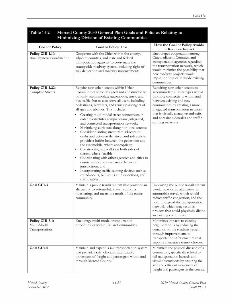
The 2030 General Plan contains proposed goals and policies in the Land Use, Circulation, and Public Facilities and Services Elements that would prevent physically dividing an established community, as shown in Table 14-2.

Land Use
Merced County 14-19 2030 Merced County General Plan November 2012 Draft PEIR
Table 14-2 Merced County 2030 General Plan Goals and Policies Relating to Minimizing Division of Existing Communities
Goal or Policy Goal or Policy Text How the Goal or Policy Avoids or Reduces Impact
Land Use Element Goal LU-1 Create a countywide land use pattern that
enhances the integrity of both urban and rural areas by focusing urban growth towards existing or suitably located new communities.
Focuses growth to existing or appropriately located new communities that integrate a compatible land use pattern, thereby minimizing development at locations that could physically divide a community or that could be divided in the future.
Policy LU-1.1: Countywide Development
Direct urban development to areas within adopted urban boundaries of cities, Urban Communities, and Highway Interchange Centers in order to preserve productive agriculture, limit urban sprawl, and protect natural resources.
Promotes land use integrity by directing development to cities with specific development plans and designated unincorporated community areas to reduce land use conflicts.
Policy LU-1.7: Compact Development
Promote compact development in urban communities that supports pedestrian activity and transit ridership.
Avoids the physical division of an existing community by focusing growth to existing neighborhoods and designated urban communities that have an existing transportation network, thereby minimizing the need for new roadways or links at locations that may separate communities.
Policy LU-1.8: Innovative Development
Promote flexibility and innovation through the use of planned unit developments, development agreements, Community Plans, Specific Plans, mixed-use projects, and other innovative development and planning techniques.
Supports the use of innovative planning processes for new development, which would minimize the likelihood that existing communities would be impacted or physically divided due to urban growth.
Policy LU-1.10: Orderly Community Growth
Require the orderly, well planned, and balanced growth of unincorporated communities consistent with the limits imposed by local infrastructure, services, public facilities, and their ability to assimilate growth.
Requiring orderly and well-planned growth minimizes impacts to existing rural communities by siting land uses within the county at suitable locations that can accommodate related infrastructure, public facilities, and services rather than at isolated locations that are not currently served by existing utilities and nearby infrastructure.
Goal LU-5.A Preserve and enhance the character of Merced County by focusing future unincorporated development towards Urban Communities.
Avoids impacts to existing and established communities by directing new development to designated urban communities, capable of accommodating future growth.

Land Use
2030 Merced County General Plan 14-20 Merced County Draft PEIR November 2012
Table 14-2 Merced County 2030 General Plan Goals and Policies Relating to Minimizing Division of Existing Communities
Goal or Policy Goal or Policy Text How the Goal or Policy Avoids or Reduces Impact
Policy LU-5.A.4: Community Plan Requirement
Prepare Community Plans for each Urban Community that includes specific local policies and land use designations within the Urban Community boundary. Each Plan shall include a full range of residential, commercial, office, mixed-use, industrial, and other urban land uses in order to accommodate all types and intensities of development commensurate to the availability of public infrastructure and services.
The preparation of Community Plans ensures that land uses are distributed at new locations, accommodate a range of development types, and are carefully planned, minimizing the possibility that an existing community would be physically divided.
Policy LU-5.A.5: Smart Growth
Promote the principles of smart growth in Community Plans for each Urban Community, including: a) creating walkable neighborhoods; b) providing a mix of residential densities; c) creating a strong sense of place; d) mixing land uses; e) directing growth toward existing
communities; f) building compactly; g) discouraging sprawl; h) encouraging infill; i) preserving open space; and j) creating a range of housing opportunities
and choices.
Promoting smart growth principles in Community Plans supports cohesiveness and connectivity within neighborhoods by providing a range and mix of land uses, encouraging infill, and creating walkable neighborhoods, thereby minimizing the physical division of an established community.
Goal LU-5.B Preserve and enhance the design, heritage, historic character, and quality of life of Urban Communities in Merced County.
Preserving the design and historic character within Merced County improves the quality of life for residents by maintaining and enhancing design features and the aesthetic character of neighborhoods, and minimizing impacts that could separate important amenities that provide communities their identity.
Policy LU-5.B.1: Community Plan Design Guidelines
Develop, maintain, and implement urban design guidelines and uniform policies in new or updated Community Plans that emphasize the individual character of each community.
Promotes the use of urban design guidelines that would promote the individual character of each community within the county, rather than impacting communities.
Policy LU-5.B.2: Major Street Corridors and Intersections
Develop illustrated design guidelines and streetscape standards for all development occurring along major street corridors and important intersections within Urban Communities.
Developed design guidelines and streetscape standards for development along street corridors and major intersections would ensure that design elements help to integrate commercial and residential uses, and promote connectivity and cohesiveness.

Land Use
Merced County 14-21 2030 Merced County General Plan November 2012 Draft PEIR
Table 14-2 Merced County 2030 General Plan Goals and Policies Relating to Minimizing Division of Existing Communities
Goal or Policy Goal or Policy Text How the Goal or Policy Avoids or Reduces Impact
Policy LU-5.B.3: Distinctive Neighborhoods
Encourage the development of diverse and distinctive communities and neighborhoods that build on the patterns of the natural landscape and existing development, and are responsive to their location and context.
Promotes the development of distinctive communities that are integrated with the natural landscape, thus minimizing the likelihood of disrupting or impacting existing neighborhoods.
Policy LU-5.B.5: Streetscape Continuity
Ensure that streetscape elements (e.g., street signs, trees, furniture) maintain a visual continuity and follow a common image for each Urban Community.
Supports the planning and construction of streetscape elements for communities, which would provide visual continuity through communities and cohesive neighborhoods.
Goal LU-7 Ensure that development in county/city fringe areas is well planned and adequately serviced by necessary public facilities and infrastructure.
Well-planned and adequately serviced communities would be less likely to require new public facilities and infrastructure, the construction and operation of which could physically divide an existing community.
Policy LU-7.1: Infill Development Focus
Encourage infill development to occur in cities in order to maximize the use of land within existing urbanized areas, minimize the conversion of productive agricultural land, and minimize environmental impacts associated with new development.
Infill development would minimize impacts associated with new development, such as the provision of new services and utilities, the construction and operation of which could physically divide an existing community.
Policy LU-7.2: Orderly Expansion
Promote orderly expansion of urban uses within City spheres of influence, recognizing the City has primary responsibility to determine the type and timing of development.
Orderly growth within Cities’ sphere of influence boundaries would minimize impacts to existing communities because growth would occur within areas designated for new development consistent with the City and County General Plan land use designations.
Policy LU-7.3: City Sphere of Influence Expansions
Support City sphere of influence expansion proposals when the City has demonstrated there is an actual need for additional land to accommodate planned growth, and documented a good faith effort to implement an infill development program(s) to minimize the conversion of productive agricultural land.
Encourages the County to support SOI expansion proposals only where there is a need to accommodate growth.

Land Use
2030 Merced County General Plan 14-22 Merced County Draft PEIR November 2012
Table 14-2 Merced County 2030 General Plan Goals and Policies Relating to Minimizing Division of Existing Communities
Goal or Policy Goal or Policy Text How the Goal or Policy Avoids or Reduces Impact
Policy LU-7.6: Policy Consultation
Promote, within City spheres of influence, consultation between the Cities and the County at the staff level in the early stages of preparing General Plan amendments and other policy changes that may impact growth or the provision of urban services. Staff consultations, particularly concerning Community Plans or Specific Plans, shall provide for meaningful participation in the policy formulation process, and shall seek resolution of issues prior to presentation to the decision-making bodies.
Encourages coordination and consultation with Cities planning for General Plan amendments and other policy changes, which would promote meaningful participation and prevent or minimize the possibility that existing communities would be negatively impacted.
Policy LU-10.2: County and City Cooperation
Work cooperatively with all Cities in the county to encourage each City to adopt and maintain its General Plan consistent with the Merced County General Plan. Adopt complementary planning policies through a cooperative planning process to be determined by the respective legislative bodies.
Cooperation with cities would ensure that land uses are consistent and complementary and that future urban development within cities SOI does not result in the physical division of an existing community.
Circulation Element Goal CIR-1 Maintain an efficient roadway system for the
movement of people and goods that enhances the physical, economic, and social environment while being safe, efficient, and cost-effective.
An efficient roadway system that is safe would minimize impacts related to the need for new roadway links that could physically divided an existing community.
Policy CIR-1.2: Efficient Transportation Network
Encourage land use patterns that promote shorter travel distances between residences and employment centers within Merced County, allow for non-auto travel, provide traffic-calming on local roadways, and promote the efficient expansion and maintenance of transportation-related infrastructure.
Land use patterns that promote shorter travel distances and integrate traffic calming would improve the connectivity of existing communities instead of physically divide communities.
Policy CIR-1.3: Transportation Efficiency
Encourage transportation programs that result in more efficient energy use, reduce greenhouse gas emissions and noise levels, and improve air quality.
A transportation program would avoid impacts to existing communities by encouraging and educating the community to utilize the existing transportation network, alternative modes of transportation, and carpooling options, which would reduce the need to construct or expand the existing roadway network, and as a result minimize the possibility of physically dividing a community due to the construction of roadways.
Land Use
Merced County 14-23 2030 Merced County General Plan November 2012 Draft PEIR
Table 14-2 Merced County 2030 General Plan Goals and Policies Relating to Minimizing Division of Existing Communities
Goal or Policy Goal or Policy Text How the Goal or Policy Avoids or Reduces Impact
Policy CIR-1.10: Road System Coordination
Cooperate with the Cities within the county, adjacent counties, and state and federal transportation agencies to coordinate the countywide roadway system, including right-of-way dedication and roadway improvements.
Encourages cooperation among Cities, adjacent Counties, and transportation agencies regarding the transportation network, which would minimize the possibility that new roadway projects would impact or physically divide existing communities.
Policy CIR-1.22: Complete Streets
Require new urban streets within Urban Communities to be designed and constructed to not only accommodate automobile, truck, and bus traffic, but to also serve all users, including pedestrians, bicyclists, and transit passengers of all ages and abilities. This includes: • Creating multi-modal street connections in
order to establish a comprehensive, integrated, and connected transportation network;
• Minimizing curb cuts along non-local streets; • Consider planting street trees adjacent to
curbs and between the street and sidewalk to provide a buffer between the pedestrian and the automobile, where appropriate;
• Constructing sidewalks on both sides of streets, where feasible;
• Coordinating with other agencies and cities to ensure connections are made between jurisdictions; and
• Incorporating traffic calming devices such as roundabouts, bulb-outs at intersections, and traffic tables.
Requiring new urban streets to accommodate all user types would promote connectivity within and between existing and new communities by creating a more integrated transportation network that is visually attractive and safe, and contains sidewalks and traffic calming measures.
Goal CIR-3 Maintain a public transit system that provides an alternative to automobile travel, supports ridesharing, and meets the needs of the entire community.
Improving the public transit system would provide an alternative to automobile travel, which would reduce traffic congestion, and the need to expand the transportation network, which may result in projects that could physically divide an existing community.
Policy CIR-3.1: Multi-Modal Transportation
Encourage multi-modal transportation opportunities within Urban Communities.
Minimizes impacts to existing neighborhoods by reducing the demands on the roadway system through improvements to transportation infrastructure that support alternative transit choices.
Goal CIR-5 Maintain and expand a rail transportation system that provides safe, efficient, and reliable movement of freight and passengers within and through Merced County.
Minimizes the physical division of a community, specifically related to rail transportation hazards and visual obstructions by ensuring the safe and efficient movement of freight and passengers in the county.

Land Use
2030 Merced County General Plan 14-24 Merced County Draft PEIR November 2012
Table 14-2 Merced County 2030 General Plan Goals and Policies Relating to Minimizing Division of Existing Communities
Goal or Policy Goal or Policy Text How the Goal or Policy Avoids or Reduces Impact
Policy CIR-5.7: High Speed Rail
Coordinate with the California High Speed Rail Authority, the Cities, and other local agencies in efforts to properly locate the High Speed Rail corridors throughout Merced County, including at least one station and a heavy maintenance facility.
Encourages the proper siting of the California High Speed Rail line in order that it does not physically divide an established community.
Public Facilities and Services Element Policy PFS-4.4: Land Use Compatibility with Solid Waste Facilities
Require that solid waste facility sites and landfills are protected from encroachment by incompatible land uses, such as schools and homes.
Avoids the division of existing communities by taking into consideration the siting of solid waste facilities during development planning.
Policy PFS-5.3: New Transmission and Distribution Lines
Encourage new transmission and distribution lines within existing utility easements and right-of-ways, joint-use of easements among different utilities.
Minimizes the division of existing communities due to the installation of new transmission or distribution lines by encouraging new lines to be installed within existing easements.
Policy PFS-5.6: Underground Power Transmission
Require power transmission and distribution facilities to be located underground within urban communities and residential centers.
Minimizes the physical division of existing communities by requiring power transmission and distribution facilities to be located underground.
Source: Merced County, 2011; Planning Partners, 2012.
Land Use Element Goal LU-1 and its supporting policies create a countywide land use pattern that enhances the integrity of both urban and rural areas by focusing urban growth towards existing or suitably located new communities, thereby minimizing the physical division of a community. Goal LU-5.A and its policies seek to preserve and enhance the character of Merced County by focusing future unincorporated development towards Urban Communities, also known as established existing planned communities. Goal LU-5.B and its supporting policies address community character and design in the effort to preserve the unique character and heritage of the county. Such goals and policies would limit the development of land uses that could contribute to an indirect physical division of established communities, such as the abandonment of older neighborhoods. Goal LU-7 would ensure development in the county/city fringe areas is well-planned and adequately serviced by necessary public facilities and infrastructure. In particular, Policy LU-7.1 encourages infill development; such development would not result in physically dividing an established community.
The Circulation Element also provides guidance on the future development of the transportation network within the county to support integrated communities. The Circulation Element contains Goals CIR-1, CIR-3, and CIR-5. Through these goals the County seeks to maintain an efficient roadway system for the movement of people and goods, a public transit system that will provide viable alternatives to automobile travel, and a rail transportation system that will serve freight and passenger needs efficiently. In addition, the County is dedicated to creating complete streets designed to establish a comprehensive, integrated, and connected transportation network, which would better connect existing communities rather than divide them. Complete streets may also reduce demands on the roadway network because they integrate infrastructure that supports alternative modes of transportation, thereby minimizing the need to widen roadways or construct

Land Use
Merced County 14-25 2030 Merced County General Plan November 2012 Draft PEIR
roadway bypasses. This policy shift would provide more transportation choices that, over time, could reduce the demands on county roadways, minimize the need for new roadway improvements, and lessen the likelihood that such improvements would physically divide communities.
In general, new development associated with the proposed 2030 General Plan would represent a continuation of the existing community areas of the county, and would not result in the physical division of an existing community within any of the county planning areas. However, although proposed goals and policies would ensure that new development would support and maintain the cohesiveness of the existing built environment, project-specific development projects at certain locations related to new development (e.g., new roadways, expanded utility and transmission lines) could physically divide existing communities. These types of major infrastructure projects would result in the construction of a physical feature that could impair connections within a community. Therefore, the urban development which would result from the implementation of the proposed 2030 General Plan would cause the siting and construction of new roadways and infrastructure corridors at certain locations that could physically divide communities and result in a potentially significant impact.
Significance of Impact: Potentially significant.
Mitigation Measures:
Revise the following policies to ensure that new links to the existing transportation network and infrastructure system, such as major roadways, rail lines, and infrastructure projects associated with urban development, do not result in the physical division of an existing community.
Mitigation Measure LU-1a:
Amend Policy CIR-1.2: Efficient Transportation Network, as follows:
Encourage land use patterns that promote shorter travel distances between residences and employment centers within Merced County, allow for non-auto travel, plan for multi-modal access for communities near I-5 and other major roadways, provide traffic-calming on local roadways, and promote the efficient expansion and maintenance of transportation-related infrastructure to avoid constructing new roadways that would cause the physical division of existing communities.
Mitigation Measure LU-1b:
Amend Policy PFS-5.3: New Transmission and Distribution Lines, as follows:
Encourage new transmission and distribution lines to be sited within existing utility easements and right-of-ways or utilize joint-use of easements among different utilities to avoid impacting existing communities.
Environmental Effects of Measures: Because these mitigation measures would apply only to developed uses and activities, there would be no additional impacts beyond those identified in Chapters 5 through 22 of this Draft PEIR.
Level of Significance After Mitigation: Less than significant.

Land Use
2030 Merced County General Plan 14-26 Merced County Draft PEIR November 2012
Implementation of Mitigation Measures LU-1a and LU-1b would result in a reduction of the potential for new development and related infrastructure due to the implementation of the 2030 General Plan to physically divide an existing community. Though specific goals and policies including those that have been revised through mitigation as proposed in the 2030 General Plan would partially offset potential future impacts related to the physical division of a community, the revised policies would ensure additional oversight is taken into consideration when siting and constructing new roadway links and utility infrastructure corridors such as major highway bypasses, interchanges, and transmission and distribution lines.
Impact LU-2: Conf l i c t with any appl i cable plan, pol i cy , or regulat ion o f a government agency with jur isdi c t ion over land in unincorporated Merced County that has been adopted for the purpose o f avoiding or mit igat ing an environmental e f f e c t .
Implementation of the proposed 2030 General Plan could lead to land use inconsistencies that would conflict with applicable plans, policies, or regulations that have jurisdiction over land use within unincorporated Merced County. Because the proposed 2030 General Plan was designed specifically to achieve and promote consistency with the planning documents of other neighboring cities and counties, and with the requirements of other land management agencies within Merced County, this impact would be less than significant.
In addition to the County, several key city, regional, state, and federal agencies would have jurisdiction over aspects of land use and future urban development within the county. Cities that may have planning policies for land uses within their SOIs would include the six incorporated cities in the county, including: Merced, Livingston, Atwater, Los Banos, Gustine, and Dos Palos. Counties that may have planning policies for lands near the county lines may include the counties of Fresno, San Benito, Santa Clara, Madera, Stanislaus, and Mariposa. Regional agencies that would have jurisdiction over specific land use or environmental issues include, but are not limited to, the San Joaquin Valley Air Pollution Control District, the Merced County Local Agency Formation Commission, and the Merced County Association of Governments. State agencies that would have land use discretion over environmental issues include the California Department of Transportation (Caltrans) and the Central Valley Regional Water Quality Control Board. Similarly, various regional, state, and federal agencies would have jurisdiction over national wildlife refuges and wildlife management areas, large-scale federal water projects, interstate highway improvements, and state parks and recreation areas.
The proposed 2030 General Plan was designed to achieve and promote consistency with the applicable plans, policies, and regulations of other governmental agencies that have jurisdiction over land use decisions. Goals and policies outlined in the 2030 General Plan under the Air Quality, Land Use, Circulation, Public Facilities and Services, Natural Resources, Cultural Resources and Recreation, Health and Safety, and Agricultural Elements would minimize land use inconsistencies. Table 14-3 lists these goals and policies.

Land Use
Merced County 14-27 2030 Merced County General Plan November 2012 Draft PEIR
Table 14-3 Merced County 2030 General Plan Goals and Policies Relating to Land Use Consistency and Compatibility
Goal or Policy Goal or Policy Text How the Goal or Policy Avoids or Reduces Impact
Air Quality Element Policy AQ-1.9: Interagency Coordination
Coordinate with cities, regional, state, and federal agencies and organizations to collaborate on a comprehensive approach to planning for climate change.
Ensures coordination among other cities, regional, state, and federal agencies, which encourages land use consistency.
Policy AQ-2.1: Air Quality Plan Compliance
Require all development projects to comply with applicable regional air quality plans and policies.
Minimizes the likelihood of land use decisions being inconsistent with air quality attainment planning by requiring compliance with all applicable regional air quality plans and policies.
Policy AQ-4.7: Planning Integration
Require land use, transportation, and air quality planning to be integrated for the most efficient use of resources and a healthier environment.
Promotes integration among land use, transportation, and air quality planning documents to minimize land use inconsistencies.
Land Use Element Policy LU-5.A.7: Municipal Advisory Council Role
Use Municipal Advisory Councils to assist the County in identifying local goals and values in preparation and implementation of Community Plans.
Minimizes the possibility that there would be land use inconsistencies among other regional land use documents through oversight provided by Municipal Advisory Councils.
Policy LU-7.5: Land Use Conflict Reduction
Encourage cities to incorporate in their General Plans land use policies that minimize potential conflicts with agriculturally-related industrial operations and other agricultural activities at the urban interface through the provision of appropriate buffers or other measures.
Minimizes potential agricultural land use incompatibilities by encouraging cities to incorporate land use policies into their General Plans to minimize agricultural related conflicts.
Policy LU-7.6: Policy Consultation
Promote, within city spheres of influence, consultation between the cities and the County at the staff level in the early stages of preparing General Plan amendments and other policy changes that may impact growth or the provision of urban services. Staff consultations, particularly concerning Community Plans or Specific Plans, shall provide for meaningful participation in the policy formulation process and shall seek resolution of issues prior to presentation to the decision-making bodies.
Encourages coordination and consultation with Cities planning for General Plan amendments and other policy changes, which would promote meaningful participation and prevent or minimize the possibility that existing communities would be negatively impacted.
Policy LU-7.7: Existing Neighborhood Policy Consistency
Encourage cities to incorporate in their General Plans County land use policies for communities/neighborhoods that were established previously under County jurisdiction.
Reduces land use conflicts in certain communities by encouraging cities to incorporate policies for communities that were previously under County jurisdiction.

Land Use
2030 Merced County General Plan 14-28 Merced County Draft PEIR November 2012
Table 14-3 Merced County 2030 General Plan Goals and Policies Relating to Land Use Consistency and Compatibility
Goal or Policy Goal or Policy Text How the Goal or Policy Avoids or Reduces Impact
Policy LU-7.11: City Consultation
Do not approve any discretionary permit for new urban development within a city sphere of influence unless the development proposal has first been referred to the City for consideration of possible annexation pursuant to the policies of this section, and provisions of any applicable City/County memorandum of understanding.
Reduces land use inconsistencies by ensuring the City considers possible annexation within their SOI before the County reviews the development proposal.
Goal LU-10 Cooperate with other local, regional, state, and federal jurisdictions and agencies in the San Joaquin Valley to achieve mutually-beneficial development, environmental, and economic goals.
Cooperation among other agencies with land use discretion would reduce land use conflicts.
Policy LU-10.2: County and City Cooperation
Work cooperatively with all cities in the county to encourage each city to adopt and maintain its General Plan consistent with the Merced County General Plan. Adopt complementary planning policies through a cooperative planning process to be determined by the respective legislative bodies.
Ensuring each city within the County adopts a General Plan consistent with the County plan would minimize land use conflicts.
Policy LU-10.3: Countywide Vision
Work cooperatively with the six cities, through MCAG, LAFCO, and other governmental organizations to agree on a countywide vision for urban growth and open space preservation using the Merced County Association of Governments Blueprint as a guide.
Cooperation among the six cities and other governmental agencies within the county would reduce land use incompatibilities.
Policy LU-10.6: Community Plan Consistency
Update the General Plan for consistency following city adoption of a General or Community Plan. Any unresolved conflicts between the County and City plans shall be identified for the decision-making bodies. Establish and maintain land use controls on unincorporated lands within the spheres of influence consistent with the policies of the County General Plan.
Timely General Plan updates would ensure the plan is consistent with other jurisdictions’ plans, policies, and regulations.
Policy LU-10.9: Air Quality Management Coordination
Coordinate with the San Joaquin Valley Air Pollution Control District and affected agencies and neighboring jurisdictions in the San Joaquin Valley Air Basin to ensure regional cooperation on cross-jurisdictional and regional transportation and air quality issues, and to establish parallel air quality programs and implementation measures, such as trip reduction ordinances and indirect source programs.
Coordination with the air district would minimize the possibility that County land use decisions would be inconsistent with air quality attainment planning.
Policy LU-10.10: San Joaquin Valley Air Pollution Control District Consultation
Consult with the San Joaquin Valley Air Pollution Control District during CEQA review for discretionary projects that have the potential for causing adverse air quality impacts. Ensure that development projects are submitted to the District for CEQA comments and review of air quality analysis.
Consultation with the Air District would ensure pertinent air quality issues are incorporated into the CEQA review for discretionary projects prior to approval, thereby minimizing the possibility that County land use decisions would be inconsistent with air quality attainment regulations.

Land Use
Merced County 14-29 2030 Merced County General Plan November 2012 Draft PEIR
Table 14-3 Merced County 2030 General Plan Goals and Policies Relating to Land Use Consistency and Compatibility
Goal or Policy Goal or Policy Text How the Goal or Policy Avoids or Reduces Impact
Policy LU-10.11: Coordination with University of California, Merced
Explore opportunities to coordinate conservation planning efforts with the University of California, Merced. This can include the consolidation of conservation planning data, the development of habitat restoration plans, or the joint undertaking of habitat restoration projects.
Minimizes land use conflicts through coordination on conservation planning efforts with the University of California, Merced.
Policy LU-10.12: Coordination with State and Federal Agencies
Continue to coordinate project review and permitting activities with applicable state and federal regulatory agencies.
Reduces the potential for land use incompatibilities and planning inconsistencies among the county and state and federal agencies by ensuring that effective coordination occurs.
Policy LU-10.14: Coordination with Regional Blueprint Planning Efforts
Continue to participate in regional planning efforts with the Merced County Association of Governments and other state partnerships.
Participation in regional planning efforts would reduce land use conflicts related to regional plan, policies, and regulations.
Circulation Element Policy CIR-6.5: Airport Land Use Compatibility Plan
Review building permits and discretionary applications in areas subject to potential safety or noise impacts from public airports to assure compatibility with the Merced County Airport Land Use Compatibility Plan or other adopted ALUC plans.
Ensures consistency with applicable Airport Land Use Compatibility Plans within the county to minimize noise and air travel impacts.
Policy CIR-6.8: Transmission Tower and Lines
Review all proposed radio, television, power, or related transmission towers and lines for appropriate location and possible air travel conflicts during the discretionary application process. All projects located in Airport Areas of Influence or in approach/departure areas will be referred to the Merced County Airport Land Use Commission for comment.
Reduces land use conflicts near public airports related to proposed transmission towers and lines by requiring that appropriate review occurs for all projects located within airport areas of influence or in approach/departure areas.
Public Facilities and Services Element Policy PFS-4.4: Land Use Compatibility with Solid Waste Facilities
Require solid waste facility sites and landfills are protected from encroachment by incompatible land uses, such as schools and homes.
Avoids land use conflicts when siting solid waste facilities.
Policy PFS-5.3: New Transmission and Distribution Lines
Encourage new transmission and distribution lines within existing utility easements and right-of-ways, joint-use of easements among different utilities.
Minimizes land use conflicts due to the installation of new transmission or distribution lines by encouraging new lines to be installed within existing easements.
Policy PFS-5.6: Underground Power Transmission
Require power transmission and distribution facilities to be located underground within urban communities and residential centers.
Minimizes land use conflicts by requiring power transmission and distribution facilities to be located underground.
Policy PFS-5.7: Utility System Expansion
Coordinate with local gas and electric utility companies in the design, location, and appropriate expansion of gas and electric systems, while minimizing impacts to agriculture and minimizing noise, electromagnetic, visual, and other impacts on residents.
Avoids poor siting of utility infrastructure by ensuring coordination with local gas and electric utility companies prior to the design and construction of expanded systems.

Land Use
2030 Merced County General Plan 14-30 Merced County Draft PEIR November 2012
Table 14-3 Merced County 2030 General Plan Goals and Policies Relating to Land Use Consistency and Compatibility
Goal or Policy Goal or Policy Text How the Goal or Policy Avoids or Reduces Impact
Policy PFS-8.1: Coordination with School Districts
Collaborate with school districts related to school facility planning issues by: a. Identifying trends in school enrollment and
development to identify future changes in enrollment and ensure that school locations and attendance boundaries enhance communities;
b. Encouraging policies to promote logical school district boundaries within a community; and
c. Working with school districts during local planning processes and review of development proposals in regards to alternative funding needed for school facilities.
Reduces land use conflicts related to school facility planning by working with school districts during the planning processes for new school facilities.
Policy PFS-8.7: Incompatible Land Uses near Schools
Coordinate with school districts to reduce the effects of incompatible land uses and noise adjacent to school facilities.
Avoids land use inconsistencies related to the siting of new school facilities through coordination with school districts.
Natural Resources Element Policy NR-1.17: Agency Coordination
Coordinate with private, local, state, and federal agencies to assist in the protection of biological resources and prevention of degradation, encroachment, or loss of resources managed by these agencies.
Ensures coordination among other local, regional, state, and federal agencies, which encourages land use and resource management consistency.
Policy NR-3.4: New Development Compatibility
Ensure that new development is compatible with existing and potential surface mining areas and operations as identified on the Mineral Resource Zone Maps prepared by the State Division of Mines and Geology and other mineral resource areas identified by the County. The County shall: a. Require development applicants near
identified mineral resources to prepare a statement that specifies why the County should permit the proposed land use and describe how the benefits of the proposed use would clearly outweigh the impacts that may limit the potential to extract mineral resources in that area.
b. Require new incompatible land uses adjacent to existing mining operations to provide a buffer between the development and adjacent mining operations adequate to mitigate significant impacts to mineral land uses. The buffer distance shall be based on an evaluation of noise, aesthetics, drainage, operating conditions, biological resources, topography, lighting, traffic, operating hours, and air quality.
Minimizes land use conflicts related to compatibility with surface mining by requiring applicants to identify mineral resources, explain why the project benefits would outweigh impacts, establish a buffer between different uses, and to provide written notification to mining operators and adjacent landowners.

Land Use
Merced County 14-31 2030 Merced County General Plan November 2012 Draft PEIR
Table 14-3 Merced County 2030 General Plan Goals and Policies Relating to Land Use Consistency and Compatibility
Goal or Policy Goal or Policy Text How the Goal or Policy Avoids or Reduces Impact
c. Require written notification to be sent to mining operators and subject landowners of land use entitlement applications for potentially incompatible land uses in areas where mining operations are currently taking place.
Policy NR-4.2: Special Review Process for Structures Adjacent to Scenic Highways
Coordinate with Caltrans, during the review of proposed structures and activities located adjacent to State-designated scenic highways, to ensure that scenic vistas and local scenic values are not significantly degraded.
Reduces scenic-related land use conflicts by requiring coordination with Caltrans during review for proposed structures within State-designated scenic highways.
Recreation and Cultural Resources Element Policy RCR-1.7: Agricultural Land Use Compatibility
Consider agriculture as a compatible land use and appropriate buffer for public and private recreation areas.
Encourages land use compatibility by considering agriculture as an appropriate land use buffer near public and private recreation areas.
Health and Safety Element Policy HS-2.2: Countywide Flood Emergency Plan
Coordinate with the cities in Merced County to develop a countywide flood emergency plan that is consistent with City General Plans.
Coordination with Cities within the county regarding flood emergency planning in City General Plans would minimize land use inconsistencies with the County General Plan.
Policy HS-4.1: Airport Land Use Compatibility Plan
Require that development around airports be consistent with the safety policies and land use compatibility guidelines contained in the Merced County Airport Land Use Commission’s adopted Airport Land Use Compatibility Plan.
Reduces land use inconsistencies by requiring development near airports to be consistent with safety policies in the applicable County airport land use plans.
Policy HS-5.3: Incompatible Land Uses
Prohibit incompatible land uses near properties that produce or store hazardous waste.
Minimizes land incompatibility by prohibiting land uses that may exhibit health hazards near sensitive uses.
Agricultural Element Goal AG-3 Minimize conflicts between productive
agricultural areas and urban land uses, and discourage the parcelization and conversion of large agricultural holdings into rural residential parcels or urban uses.
Reduces land use conflicts between agricultural areas and urban land uses by discouraging the conversion of agricultural land to urban uses.
Policy AG-3.2: Agricultural Buffer
Require buffers between proposed non-agricultural uses and adjacent productive agricultural operations to protect farms, dairies, and agricultural-related production facilities from conflicts with non-agricultural uses, specifically residential development.
Buffers between non-agricultural uses and agricultural uses would minimize land use conflicts and maintain productive farmland.
Policy AG-3.3: Agricultural Buffer Standards
Establish agricultural buffer standards based on type of agricultural operation to be applied to residential development proposals adjacent to productive agricultural land and agricultural-related facilities.
Establishing agricultural buffer standards would reduce related agricultural and urban land use conflicts.

Land Use
2030 Merced County General Plan 14-32 Merced County Draft PEIR November 2012
Table 14-3 Merced County 2030 General Plan Goals and Policies Relating to Land Use Consistency and Compatibility
Goal or Policy Goal or Policy Text How the Goal or Policy Avoids or Reduces Impact
Policy AG-3.4: Residential Buffers from Agriculture
Require a minimum 200-foot buffer between new residential development and existing agricultural operations, and establish design/maintenance guidelines for developers and property owners.
Minimizes land use conflicts by requiring a minimum buffer standard between new residential development and existing agricultural operations.
Source: Merced County, 2011; Planning Partners, 2012.
The Land Use Element contains Goals LU-7 and LU-10 and their supporting policies that are designed to ensure that successful coordination occurs between the various local, regional, state, and federal agencies that have planning and permitting responsibilities in Merced County. Goal LU-10 contains 14 supporting policies, including Policies LU-10.2, LU-10.3, and LU-10.6, which require cooperation with the six cities within the county, and other agencies, to ensure land use consistency among the various general plan documents. Several policies within the Circulation Element, Public Facilities and Services Element, Natural Resources Element, and Recreation and Cultural Resources Element also encourage the development of a uniform land use policy with other local jurisdictions and support continued participation by the County in regional transportation, public services, and environmental planning programs administered by a variety of agencies including the Merced County Association of Governments (MCAG), the California Department of Transportation (Caltrans), and the San Joaquin Valley Air Pollution Control District (SJVAPCD).
The intent of the proposed 2030 General Plan is to ensure that existing and future land uses result in compatible, consistent, and uniform land uses, and that they do not impose land use conflicts, health hazards, or nuisance conditions upon adjacent uses. Land uses within identified urban areas are expected to be compatible with one another because 2030 General Plan policies establish extensive guidelines and application requirements for consistent and compatible development, particularly in new urban communities. In rural areas of the county, the proposed 2030 General Plan does not specifically identify the need to coordinate with other land management entities in the county such as the U.S. Fish and Wildlife Service (wild life refuges, wildlife management areas), California Department of Fish and Game (wildlife areas, wildlife management areas), or the several Resource Conservation Districts. The County will ensure that future CEQA documentation prepared for individual projects will, if technically feasible, mitigate any potential land use impacts to a less-than-significant level. Because these various policies encourage the placement of compatible urban and urban/agricultural interface land uses, and encourage planning and coordination between land uses under jurisdiction of the County and federal, state, or regional conservation and land management agencies, no land use incompatibilities would result. For these reasons, this impact would be considered to be less than significant.
Significance of Impact: Less than significant.
Mitigation Measure: None required.