Embed Size (px)
Citation preview
City of Virginia Beach Comprehensive Plan – It’s Our Future: A Choice City
November 20, 2018
Suburban Areas /1-59
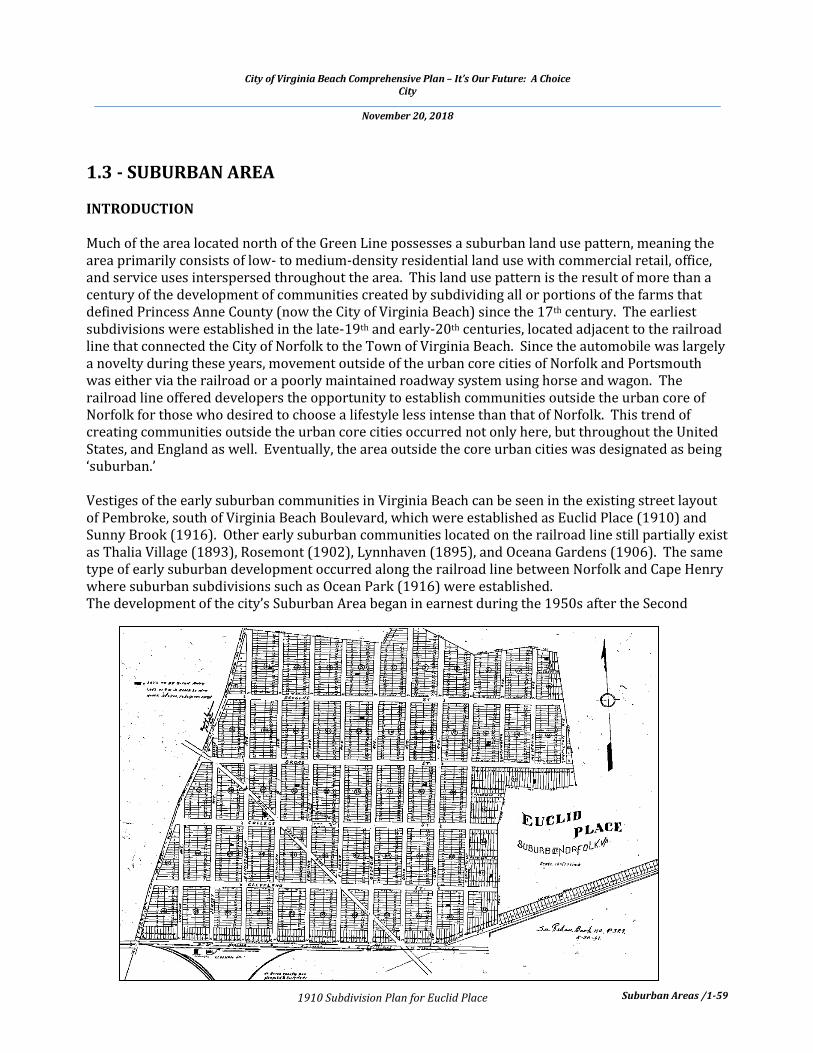
1.3 - SUBURBAN AREA INTRODUCTION Much of the area located north of the Green Line possesses a suburban land use pattern, meaning the area primarily consists of low- to medium-density residential land use with commercial retail, office, and service uses interspersed throughout the area. This land use pattern is the result of more than a century of the development of communities created by subdividing all or portions of the farms that defined Princess Anne County (now the City of Virginia Beach) since the 17th century. The earliest subdivisions were established in the late-19th and early-20th centuries, located adjacent to the railroad line that connected the City of Norfolk to the Town of Virginia Beach. Since the automobile was largely a novelty during these years, movement outside of the urban core cities of Norfolk and Portsmouth was either via the railroad or a poorly maintained roadway system using horse and wagon. The railroad line offered developers the opportunity to establish communities outside the urban core of Norfolk for those who desired to choose a lifestyle less intense than that of Norfolk. This trend of creating communities outside the urban core cities occurred not only here, but throughout the United States, and England as well. Eventually, the area outside the core urban cities was designated as being ‘suburban.’ Vestiges of the early suburban communities in Virginia Beach can be seen in the existing street layout of Pembroke, south of Virginia Beach Boulevard, which were established as Euclid Place (1910) and Sunny Brook (1916). Other early suburban communities located on the railroad line still partially exist as Thalia Village (1893), Rosemont (1902), Lynnhaven (1895), and Oceana Gardens (1906). The same type of early suburban development occurred along the railroad line between Norfolk and Cape Henry where suburban subdivisions such as Ocean Park (1916) were established. The development of the city’s Suburban Area began in earnest during the 1950s after the Second
1910 Subdivision Plan for Euclid Place

City of Virginia Beach Comprehensive Plan – It’s Our Future: A Choice City
November 20, 2018
Suburban Areas /1-60
Characteristic Suburban Area Land Use Pattern
World War. It was this initial phase of suburban development that placed the automobile at the core of the design of the Suburban Area. Instead of the small rectangular lots of the early part of the 20th century, lots were of various shapes, larger, and served by a system of local, collector, and arterial roadways. Development slowly increased during the 1960s, followed by exponential increases during the 1970s and 1980s, during which Virginia Beach was one of the fastest growing cities in the United States. Movement through the area and to destinations outside the area is heavily dependent on the automobile, which in turn is dependent on a network of roadways that has traditionally been designed to move automobiles from one place to another in the fastest and safest manner. The Master Transportation Plan (Chapter 2, Section 2.1) describes this transportation system in detail, explains the issues we face, and provides recommended policies and capital improvements to create a system that, over time, will reduce our dependence on the automobile. The need to diversify the means by which we move through the Suburban Area and, thereby, reduce our dependence on the automobile, combined with a reduction in the number of acres of land available for new development, has increased the importance of our Strategic Growth Areas, as explained in Section 1.2 – Urban Areas. Accordingly, portions of the City’s Suburban Area are undergoing a transformation to an urban land use pattern, guided by the master plans for eight Strategic Growth Areas as well as the policies and guiding principles for the City’s Urban Areas, as presented in Section 1.2. The guiding planning principles for the Suburban Area recognize this transformation as part of a maturing city, offering new types of land use and lifestyle choices. These guiding principles also emphasize the importance of the ‘edges’ or boundaries where the land use intensity and density of the Suburban Area transitions to that of the Urban Areas. Equally, the guiding principles for the Suburban

City of Virginia Beach Comprehensive Plan – It’s Our Future: A Choice City
November 20, 2018
Suburban Areas /1-61
Stable suburban neighborhood
Area recognize the city’s original rural land use pattern and lifestyle by ensuring that development along the southern edge of the Suburban Area has a lower density and intensity and possesses site and building designs that ensure an appropriate change from the Suburban Area to Princess Anne Commons and the Transition Area, and ultimately, to the Rural Area. The guiding principles presented below work in concert with this Plan’s guiding principles for the Urban and Rural Areas, as well as Princess Anne Commons and the Transition Area, to ensure that the diversification in land use and lifestyle choices is acknowledged, while also ensuring the Suburban Area continues to be an area of stability, sustainability, and quality.
GUIDING PLANNING PRINCIPLES Three guiding planning principles have been established to guard against possible threats to the stability of Suburban Area and to provide a framework for neighborhoods and places that are increasingly vibrant and distinctive. This is accomplished by providing planning guidance that ensures appropriate and sustainable use of land, the protection of natural and designed open spaces as well as places and buildings or cultural and historic significance, and the provisions of utilities, transportation, and services adequate to meet existing and future needs. Create and Maintain Neighborhood Stability and Sustainability – create “Great Neighborhoods” “Neighborhoods” may be defined as a cohesive arrangement of properties, structures, streets, and uses, within an area most or all of which is residential, that shares distinct physical, social, and economic characteristics. Creating and maintaining a stable and sustainable
neighborhood is difficult. We are fortunate, however, that the majority of the neighborhoods in the City of Virginia Beach are stable, even though much of the city’s housing is aging, some in excess of 50 years of age. The majority of the city’s neighborhoods also possess a high degree of social connectivity and civic activism, which are vital for maintaining stability. Our primary guiding principle for the Suburban Area is to create “Great Neighborhoods,” and to support those neighborhoods with complementary non-residential uses in such a way that working together the stability and sustainability of the Suburban Area is ensured for now and the future. To achieve this objective, the following are to be sought in the development of new residential areas and used in the assessment of their compatibility with surrounding areas:
GUIDING PRINCIPLES FOR THE
SUBURBAN AREA
Create and maintain neighborhood stability and sustainability – create “Great Neighborhoods.”
Protect and enhance natural open spaces and places and buildings of cultural and historic significance and integrate into development as appropriate.
Create and maintain a transportation system that provides connectivity and enhances mobility regardless of transportation mode.

City of Virginia Beach Comprehensive Plan – It’s Our Future: A Choice City
November 20, 2018
Suburban Areas /1-62
Well-designed multi-family residential development with amenities
Careful mix of land uses that contributes to the day-today life of our residents Site and building design that is visually interesting, encourages greater social interaction, and
provides a memorable character Compatible infill development Accommodate multiple modes of transportation (e.g., pedestrians, bicyclists, and drivers) Promote sustainability and responsive to changes in our environment (e.g., sea level rise)
Several of the items above are based on ‘Characteristics of a Great Neighborhood’ as defined by the American Planning Association, as part of its “Great Places in America” program. Among them is a predominant emphasis on design of both the neighborhood and the dwellings; therefore, the Special Area Development Guidelines: Suburban Area found in the Reference Handbook are to be extensively used to guide and evaluate existing and new development within the Suburban Area. For example, new residential development on larger parcels should be consistent with the character of any residential uses in the surrounding area, as well as consistent with the guiding planning principles for the Suburban Area. Residential density in the Suburban Area should be low to medium where the surrounding land use patterns and densities are appropriate for such. Higher densities are appropriate for development in the Urban Areas. Design plays an important role in the encouragement of social interaction and providing for a quality day-to-day experience. Equally important, however, are the institutions that support residents, such as religious uses, community centers, and schools. In particular, schools have always played a significant role in the lives of Virginia Beach residents through not only the education provided, but also by acting as centers of community activity. The quality of the educational experience and the community focus of our schools have been, and continue to be, a primary contributor to the desire of people to live in Virginia Beach, and accordingly, a driver of the City’s growth. Further discussion of this aspect of the Suburban Area can be found in
Floyd E. Kellam High School

City of Virginia Beach Comprehensive Plan – It’s Our Future: A Choice City
November 20, 2018
Suburban Areas /1-63
The Residential Pattern Book provides guidance for renovation of existing houses and construction of infill housing
Underutilized neighborhood shopping center
the Virginia Beach Public Schools’ Compass to 2020 Strategic Plan, which is available online at http://www.vbschools.com/compass. Infill development on small vacant parcels within an existing neighborhood or on parcels being redeveloped should be compatible to the existing development around it. Designing a structure that is scaled and proportioned with surrounding development is typically more difficult than utilizing a design that simply fits the site and meets zoning regulations. The result, however, is a structure compatible with the neighborhood with respect to land use and design, and will give the impression to those who pass by that it has always been part of the original development. There is a limited amount of design guidance for infill development in the Special Area Development Guidelines: Suburban Area. Though it is focused on infill development in the Oceanfront neighborhood of Shadowlawn, the Shadowlawn Infill Development Guidelines, which are part of the Reference Handbook, provides insight into principles of developing small infill lots. Finally, development on smaller parcels, whether infill or renovation of existing dwellings should be guided by the Virginia Beach Residential Pattern Book and Resource Manual, which is available online at http://www.vbgov.com/government/departments/housing-neighborhood-preservation/homeowners/Pages/vb-pattern-book.aspx. Further discussion of infill development is found in Chapter 2, Section 2.3 - Housing and Neighborhoods Plan. Land use compatibility among uses within the Suburban Area is vital to the stability of the city’s neighborhoods. Equally as vital, however, is the compatibility of land uses within the Suburban Area with those of the Urban Area, Princess Anne Commons, Transition Area, and Rural Area. At these transitional ‘edges’ from Suburban Area to Urban Areas and Suburban Area to Transition Area to Rural Area, it is critical that the Special Area Development Guidelines: Suburban Area be used in concert with the Special Area Development Guidelines: Urban Areas and the Rural Development Guidelines dependent on which ‘edge’ is involved. Moreover, additional guidance pertaining to these edges is provided in the planning documents for each of the Strategic Growth Areas.

City of Virginia Beach Comprehensive Plan – It’s Our Future: A Choice City
November 20, 2018
Suburban Areas /1-64
To create and maintain “Great Neighborhoods,” emphasis on the residential component must be balanced by an emphasis on the commercial component. Each land use is dependent on the other, and accordingly, the quality and vitality of one affects that of the other. Just as the City’s housing is aging, many of our neighborhood commercial centers are aging and showing deteriorated through years of neglect by the owners. We cannot afford to allow such deterioration to continue, as there will be a corresponding effect on our neighborhoods until eventually, a cycle of decline of both occurs. Many of the centers serve as the core of the community. The demise of neighborhoods is quickened when they are in the vicinity of abandoned aging centers, while, at the same time, development of new centers elsewhere is allowed. It is vital, therefore, that we encourage the renewal of such centers with regard to both design and the products and services provided to the neighborhoods where they are located. We must be innovative using financial, zoning, and other tools yet to be determined to encourage owners to renew these commercial centers. For example, allowing dwelling units to be added to such centers will mix land uses in a way that new customers located in close proximity are provided to businesses and additional income is provided to the property owner that can be used to renew the center. Another example is use of underutilized areas of parking lots for markets of various types (e.g., farm produce; home gardening plants and supplies, etc.). Of importance to our neighborhoods as well is ensuring that principles of sustainability are incorporated into our neighborhoods to make sure that future residents of our neighborhoods can enjoy the same, and potentially even better, quality of life than current residents do. Chapter 2, Section 2.2 - Environmental Stewardship Framework, as well as the City’s A Community Plan for a Sustainable Future (commonly referred to as The Sustainability Plan) provide policies and strategies to that end. Protect and Enhance Natural Open Spaces, Places and Building of Cultural and Historical Significance and Integrate into Development as Appropriate Over the long term, the quality of the physical environment within the Suburban Area will be impacted by how well we protect and enhance its physical assets including open spaces. Carefully planned open space areas also add to the attractiveness and livability of our suburban neighborhoods. They also have a positive effect on the market value of surrounding properties and, thus, help to advance our City’s economic vitality. Significant multiple benefits are derived from this amenity and, as such, it is important for the City to continue providing sufficient resources to ensure an effective, on-going open space
Example of food truck bringing vitality to vacant neighborhood shopping center parking lot as part of
a farm market
Attractive park and open space design provides amenities for neighborhood residents
City of Virginia Beach Comprehensive Plan – It’s Our Future: A Choice City
November 20, 2018
Suburban Areas /1-65
preservation and acquisition program as identified in the Virginia Beach Outdoors Plan and within other areas of the City, as deemed appropriate. The following should guide the protection and enhancement of our open spaces as well as the buildings and places of cultural and historic significance within the City:
Maintain Existing open Spaces and Parks
We must ensure that sufficient resources are available to adequately maintain existing public open space, parks, and recreation areas. We must also develop tools that assist neighborhoods developed with open space areas and parks but which are now difficult to maintain due to declining revenues of property owners associations.
Create New Open Spaces with Development, including City Capital Improvement Program
Projects
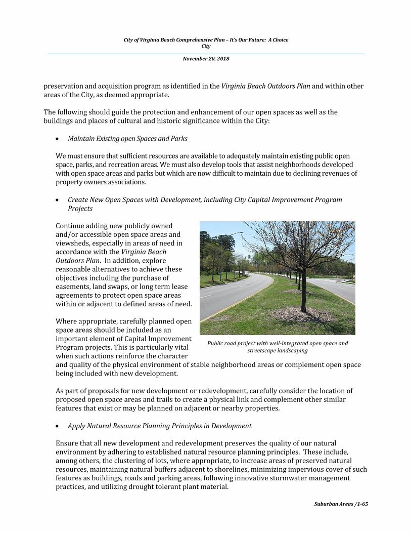
Continue adding new publicly owned and/or accessible open space areas and viewsheds, especially in areas of need in accordance with the Virginia Beach Outdoors Plan. In addition, explore reasonable alternatives to achieve these objectives including the purchase of easements, land swaps, or long term lease agreements to protect open space areas within or adjacent to defined areas of need.
Where appropriate, carefully planned open space areas should be included as an important element of Capital Improvement Program projects. This is particularly vital when such actions reinforce the character and quality of the physical environment of stable neighborhood areas or complement open space being included with new development.
As part of proposals for new development or redevelopment, carefully consider the location of proposed open space areas and trails to create a physical link and complement other similar features that exist or may be planned on adjacent or nearby properties.
Apply Natural Resource Planning Principles in Development
Ensure that all new development and redevelopment preserves the quality of our natural environment by adhering to established natural resource planning principles. These include, among others, the clustering of lots, where appropriate, to increase areas of preserved natural resources, maintaining natural buffers adjacent to shorelines, minimizing impervious cover of such features as buildings, roads and parking areas, following innovative stormwater management practices, and utilizing drought tolerant plant material.
Public road project with well-integrated open space and streetscape landscaping

City of Virginia Beach Comprehensive Plan – It’s Our Future: A Choice City
November 20, 2018
Suburban Areas /1-66
Historic Adam Thoroughgood House
We should also ensure that new development responds to the effects of projected sea level rise as well as the recurrent flooding that occurs in areas of the City.
Southern Watershed Subject to “Special Drainage Considerations”
In addition, the Southern Watershed portion of the Suburban Area is subject to “special drainage considerations.” Drainage in the Southern Watershed is highly impacted by the presence of high ground water, poorly draining soils, and high water surface elevations in downstream receiving waters. Therefore, it is incumbent upon the developer of any property in the Southern Watershed to understand and evaluate these factors prior to undertaking the project and to properly account for these factors in the project design. Receiving waters in the Southern Watershed are subject to tidal influences which can be exacerbated by winds. High ground water elevations and poorly draining soils can result in increased runoff, can limit the capacity of the stormwater conveyance systems, and can counter indicate the use of certain Best Management Practices, such as infiltration.
All of these effects must be fully considered and evaluated in the analysis and design of drainage systems in the Southern Watershed. Accordingly, it is strongly recommended that the developer has a preliminary drainage study prepared by a qualified professional engineer in advance of any request to approve a discretionary (versus by-right) development application that involves land disturbance in the Southern Watershed. The drainage study should fully and accurately evaluate the effects of the foregoing factors on the planned development and on upstream and downstream areas. The proposed drainage system for the planned development would provide positive drainage that meets City standards and does not result in flooding within the planned development or to upstream or downstream areas.
Protect Resources of Historic and Cultural Significance
Coupled with protecting open space is the importance of protecting our resources of historic and cultural significance. It is the policy of the City to use all available resources, including those provided by the City’s Historic Review Board, Historic Preservation Commission, as well as the Princess Anne County/Virginia Beach Historical Society, to preserve such resources. Efforts to retain these historic resources should be accomplished in a responsible and innovative manner. The efforts include providing land use planning guidance and tax credit assistance to owners of historic properties in

City of Virginia Beach Comprehensive Plan – It’s Our Future: A Choice City
November 20, 2018
Suburban Areas /1-67
Construction of new Lesner Bridge Replacement over Lynnhaven Inlet
order to help protect and preserve the City’s limited number of valuable historic resources and surrounding open space areas. Owners of qualified properties should be encouraged to participate in the Virginia Beach Historical Register program and receive recognition for their contributions to our City’s heritage.
Create and Maintain a Transportation System that Provides Connectivity and Enhances Mobility
Regardless of Transportation Mode
Movement through the Suburban Area and to destinations outside the Suburban Area is heavily dependent on the automobile, which in turn is dependent on a network of roadways that has traditionally been designed to move automobiles from one place to another in the fastest and safest manner. Currently, a conflict exists between the goal of encouraging the public to use transit service and other modes of travel and the limited demand for such services in a typical suburban setting. A disproportionate reliance on the automobile, often with only a single occupant, creates these negative results:
Declining environmental quality; Inefficient use of energy resources; Stress on the economy due to increased costs to residents to maintain vehicles and help pay for
system improvements; Stress on the public sector due to the need to find innovative means to fund improvements to
the existing system, the development of new systems, and the maintenance of the complete transportation system;
Time lost due to congestion; and, A reduction in quality of life due to all of the above.
Chapter 2, Section 2.1 - Master Transportation Plan describes this transportation system in detail, explains the issues we face, and provides recommended policies and capital improvements to create a system that, over time, will reduce our dependence on the automobile.

City of Virginia Beach Comprehensive Plan – It’s Our Future: A Choice City
November 20, 2018
Suburban Areas /1-68
Traffic calming technique - traffic circle or roundabout
NEIGHBORHOOD TRAFFIC CALMING There are ways to slow vehicular movement inside residential areas and reduce ‘cut through’ traffic. Often called ‘Traffic Calming’, these techniques include assessing the neighborhood traffic condition and, if warranted, providing greater police enforcement, limiting direct access to neighborhoods from adjoining roadways, adding traffic circles, narrowing street widths in certain areas and the use of other methods to reduce traffic volume and speed. The City has instituted a multi-step ‘Traffic Calming’ program to accomplish these objectives and this program should be used, where necessary, to increase public safety within neighborhoods. AREA-SPECIFIC PLANNING RECOMMENDATIONS FOR SITES IN THE SUBURBAN AREA – SUBURBAN FOCUS AREAS (SFAs) The following section of this chapter provides more refined planning guidance for designated Suburban Focus Areas (SFAs) throughout the Suburban Area. Much of the Suburban Area comprises well-established neighborhood and commercial areas that define the land use character in the northern portion of the City and should remain that way into the foreseeable future. However, opportunities to reinforce or revitalize certain areas by providing compatible land use guidance or recommendations to improve the quality of land use exists on certain suburban tracts. The purpose of Suburban Focus Areas is to offer guidance to advance these objectives. In some cases, area master plans have been developed for designated SFAs (e.g., Historic Kempsville Area, Shore Drive Corridor, and the Virginia Aquarium & Owls Creek Area). There are 9 SFAs designated in the Comprehensive Plan, which can be found on the locator map on p. 1-69:
1. Shore Drive Corridor 2. North Courthouse/South Holland Road 3. Historic Kempsville Area 4. Virginia Aquarium & Owls Creek Area 5. First Colonial Medical Corridor 6. Sandbridge 7. North End 8. Military Highway Corridor 9. Historic Seatack

City of Virginia Beach Comprehensive Plan – It’s Our Future: A Choice City
November 20, 2018
Suburban Areas /1-69
SUBURBAN FOCUS AREAS LOCATOR MAP
City of Virginia Beach Comprehensive Plan – It’s Our Future: A Choice City
November 20, 2018
Suburban Areas /1-70
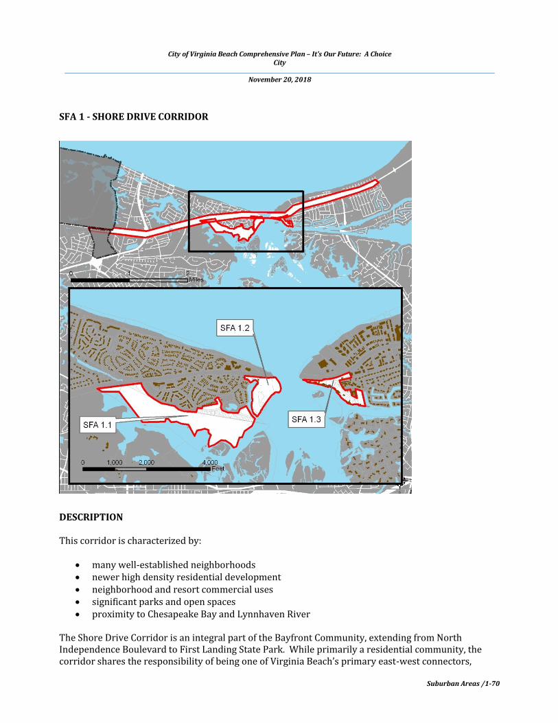
SFA 1 - SHORE DRIVE CORRIDOR
DESCRIPTION This corridor is characterized by:
many well-established neighborhoods newer high density residential development neighborhood and resort commercial uses significant parks and open spaces proximity to Chesapeake Bay and Lynnhaven River
The Shore Drive Corridor is an integral part of the Bayfront Community, extending from North Independence Boulevard to First Landing State Park. While primarily a residential community, the corridor shares the responsibility of being one of Virginia Beach’s primary east-west connectors,

City of Virginia Beach Comprehensive Plan – It’s Our Future: A Choice City
November 20, 2018
Suburban Areas /1-71
creating unique and sometimes problematic challenges. The area is considered a resort neighborhood and not a resort destination. This means that the Shore Drive Corridor:
while the most densely populated area of the City, is primarily a neighborhood residential area; comprises commercial uses to support the neighborhoods; accommodates Shore Drive, a primary circulation corridor for the City; and, affords more passive recreational and tourism amenities.
The Bayfront Advisory Commission (originally established as the Shore Drive Advisory Committee and then the Bayfront Advisory Committee) was established by City Council in 1998. The mission given by City Council to the Bayfront Advisory Commission is:
. . . to review and make recommendations to the City Council regarding public and private projects and issues associated with the Bayfront area, and projects or issues associated with the Bayfront area that the City Council may refer to the Commission.
More information is provided in the Shore Drive Corridor Plan, adopted by the City Council in 2000. The Shore Drive Corridor Design Guidelines provide direction for the form and function of land use and development in this area. Both of these documents are available in the Planning Department’s online Document Library at www.vbgov.com/Planning. The planning policies that apply to the entire Shore Drive Corridor and Bayfront Communities are:
Completion of the remaining roadway improvements (all identified Phases) along Shore Drive to enhance the safety, access, and character of the Corridor;
Retain the majority of Shore Drive, particularly east of the bridge, as a four-lane road for as long as is practical, but protect the necessary right-of-way for an expansion to a six-lane facility, if necessary. Any increase in the number of lanes on Shore Drive could negatively impact the community by further separating the northern and southern parts of the Corridor;
Ensure safe passage by pedestrians from one side of Shore Drive to the other side through reduced speed limits and well-identified pedestrian crossings;
Ensure the safety of bicyclists using Shore Drive; Preserve and protect the character of the established neighborhoods; Improve land use compatibilities and avoid over-commercialization to insure that resort-based
uses complement rather than dominate this corridor; Encourage reuse and revitalization of existing commercial properties; Achieve the lowest reasonable density for future residential uses; Develop a strategy for addressing projected sea level rise as well as the recurrent flooding that
occurs in this area; Update the Shore Drive Corridor Design Guidelines, and in particular, develop design guidance
for residential development within the Corridor and its established neighborhoods; Improve public parking and public access to the beachfronts; Provide a continuous multipurpose trail through this corridor (reference the Virginia Beach
Outdoors Plan for recommendations); and, Provide continued support for restoring the health of the Chesapeake Bay and Lynnhaven
River.

City of Virginia Beach Comprehensive Plan – It’s Our Future: A Choice City
November 20, 2018
Suburban Areas /1-72
This Suburban Focus Area has three sub-areas that, due to unique issues and/or opportunities, require further guidance. The following sections provide specific planning guidance for each. SFA 1.1 – PLEASURE HOUSE POINT
Maintain and protect the significant investment that has been made to preserve Pleasure House Point for open space, limited recreation, natural resource preservation, and natural resource education.
Ensure that any development in the surrounding area is complementary with regard to both design and land use to the natural resource and open space amenity provided by Pleasure House Point.
SFA 1.2 – LYNNHAVEN BOAT AND BEACH FACILITY
Continue as a public waterway access for motorized and non-motorized watercraft; Add appropriately scaled public park and recreational facilities; and, Provide linkage to Shore Drive trail system and Chesapeake Bay beaches.
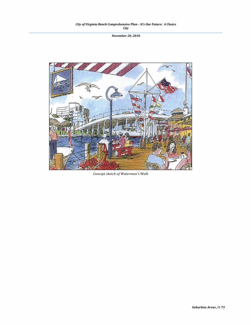
SFA 1.3 – WATERMAN’S WALK
Coordinate with property owners to create a thematic waterfront concourse overlooking the Lynnhaven Inlet;
Create a special place for people to shop, work, live, and enjoy the exceptional waterfront amenities;
Consider establishing a public-private partnership to achieve this vision; and, Integrate a variety of appropriately scaled mixed uses including marinas, restaurants,
residential units, specialty retail shops, and offices.
Pleasure House Point
City of Virginia Beach Comprehensive Plan – It’s Our Future: A Choice City
November 20, 2018
Suburban Areas /1-73
Concept sketch of Waterman's Walk

City of Virginia Beach Comprehensive Plan – It’s Our Future: A Choice City
November 20, 2018
Suburban Areas /1-74
SFA 2 – NORTH COURTHOUSE/SOUTH HOLLAND ROAD
DESCRIPTION This area has the following characteristics:
Location within the 70 to 75 dB DNL AICUZ and the 65 to 70 dB DNL (Sub-Area 2) AICUZ Location north of the Green Line at the edge of the Suburban Area and adjacent to SEGA 4 -
Princess Anne Commons, as well as the Municipal Center and Courthouse Stable and well-established neighborhoods Proximity to new roadways: Princess Anne Road, Nimmo Parkway, and Holland Road Undeveloped areas, with some consisting of one or two parcels and property owners and
others consisting of multiple parcels and multiple (and in some cases, undetermined) property owners

City of Virginia Beach Comprehensive Plan – It’s Our Future: A Choice City
November 20, 2018
Suburban Areas /1-75
Aerial photograph of SFA 2 and surrounding area
Historical, architectural, and archaeological resources
With the improvement of Princess Anne Road from a two-lane roadway to its current four-lane parkway, the improvement of Holland Road from a two-lane roadway to a four-lane arterial, and the completion of Nimmo Parkway from the Courthouse to General Booth Boulevard, this area is now well-served by the transportation system and strategically located for appropriate development. Princess Anne Road, a major north to south roadway, has been widened and improved with its own special unifying 'brand' of significant attractive landscaping, open space, multi-use paths, and pedestrian lighting. Nimmo Parkway is now a major east to west arterial roadway with multi-use paths, providing a connection from this area to General Booth Boulevard and the trail adjacent to it. Scheduled for completion in 2017, construction has begun to widen and improve Holland Road with sidewalks, aesthetic treatments, and landscaping from Dam Neck Road to Nimmo Parkway. Commercial and residential development continues to be attracted to the area as evidenced by the 240-unit multifamily complex developing behind the shopping center on Nimmo Parkway and the numerous businesses located nearby. Additionally, several large tracts of undeveloped land provide exceptional development opportunities for a variety of uses ranging from residential to commercial projects, all dependent, however, on the compatibility of any proposed use to the AICUZ of the site.

City of Virginia Beach Comprehensive Plan – It’s Our Future: A Choice City
November 20, 2018
Suburban Areas /1-76
Hampton Roads Joint Land Use Study The City of Virginia Beach has adopted a series of policies and ordinances to achieve objectives outlined in the Hampton Roads Joint Land Use Study and the City's Oceana Land Use Conformity Program. These provisions apply to most of the North Courthouse / South Holland Area. For areas within the 70 and higher dB DNL AICUZ, development of property for residential use is limited to what is already zoned for such use. Other properties, located within the 65 to 70 dB DNL AICUZ, may be developed through a change of zoning consistent with Article 18 of the City Zoning Ordinance. Access Controlled Roadways Policy - Nimmo Parkway and Princess Anne Road Nimmo Parkway and this section of Princess Anne Road are designated by the Master Transportation Plan (Chapter 2, Section 2.1) as “Access Controlled” roadways, which means private direct access to Nimmo Parkway and Princess Anne Road is not permitted, except when a property has no other reasonable access to the roadway system. In such cases, direct access is allowed until such time that access can be gained from the back of the lot by some means, such as a new roadway. Many times, these roadways are purposefully planned and constructed as part of a large development and are referred to a ‘reverse frontage’ roads. SFA 2 - GENERAL RECOMMENDATIONS With regard to residential development, when found to be an appropriate land use, the following recommendations focus on providing a density range between 'baseline' and ‘incentive.’ The incentive level relies on development options and performance guidelines to help achieve the objectives of creating well-planned developments, protecting existing neighborhoods, and implementing the policies of the Master Transportation Plan with respect to roadway access. Baseline options apply to development proposals that are limited in achievement of meeting the planning objectives for the North Courthouse/South Holland Area. Incentive options apply to development proposals that meet or exceed these planning objectives. The level of density recommended within each Subarea will be commensurate with the degree to which the development integrates the general and Subarea-specific recommendations, but more importantly to what is appropriate under the provisions of Section 1804 of the Zoning Ordinance. The following recommendations should be applied to the North Courthouse/South Holland Road Suburban Focus Area:
As many parcels as possible within SFAs 2.1, 2.2, and 2.3 should be consolidated into a single, well-configured tract of land that enables a safe, coordinated, and attractively designed development plan.
Proposed uses should reinforce and emphasize the character of the area and should be compatible with the adjacent neighborhoods.
Significant landscape buffers should be established between existing residential areas and proposed developments and roadways to mitigate adverse visual and noise concerns.
Site designs and buildings should complement the Municipal Center to the south. Integrate adjacent land uses such that each complements the other visually, functionally, and
spatially with attractive landscaped vistas, open space areas and multipurpose trails, and other amenities to enhance the quality of the physical environment and provide connectivity.

City of Virginia Beach Comprehensive Plan – It’s Our Future: A Choice City
November 20, 2018
Suburban Areas /1-77
Open space areas and vistas should include preservation of mature tree stands and have significant landscaping.
Design streets and stormwater management facilities using aesthetic and environmental design techniques to enhance scenic and open space opportunities.
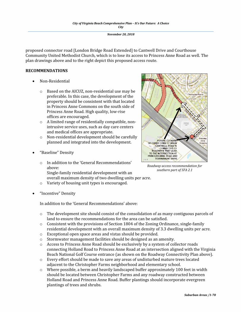
SFA 2.1 – NORTH COURTHOUSE Bounded on the north by the proposed Southeastern Parkway interchange, on the south and east by the Christopher Farms subdivision, and to the west by Princess Anne Road, the North Courthouse SFA consists of approximately 100 acres and includes numerous privately-owned parcels with a few single-family residences. It is located within the 65 to 70 dB DNL AICUZ (Sub-Area 2), and thus, residential development is subject to the AICUZ Overlay Ordinance, Section 1804. One of the goals for SFA 2.1 is that properties will be accessed by a proposed connector road (London Bridge Extended) that would cross through this area to link Holland Road with Princess Anne Road, aligning with the entrance to the Virginia Beach National Golf Course. The City Council has identified the roadway system as shown on the connectivity plan below as guidance for properties as SFA 2.1 develops. These connections will ensure that all of the properties have access to Princess Anne Road at one location, consistent with the Controlled Access designation for Princess Anne Road. Furthermore, one of the conditions of approval for the Princess Anne Crossing subdivision was that the intersection at Curry Comb Court and Princess Anne Road was temporary, and, following the widening of Princess Anne Road, Curry Comb Court would be closed and an alternative roadway access would be provided. This alternative new roadway access would be provided via a portion of the proposed connector road [London Bridge Road Extended] and a new roadway link connecting the
City of Virginia Beach Comprehensive Plan – It’s Our Future: A Choice City
November 20, 2018
Suburban Areas /1-78
proposed connector road [London Bridge Road Extended] to Cantwell Drive and Courthouse Community United Methodist Church, which is to lose its access to Princess Anne Road as well. The plan drawings above and to the right depict this proposed access route. RECOMMENDATIONS
Non-Residential o Based on the AICUZ, non-residential use may be
preferable. In this case, the development of the property should be consistent with that located in Princess Anne Commons on the south side of Princess Anne Road. High quality, low-rise offices are encouraged.
o A limited range of residentially compatible, non-intrusive service uses, such as day care centers and medical offices are appropriate.
o Non-residential development should be carefully planned and integrated into the development.
“Baseline” Density
o In addition to the ‘General Recommendations’
above: Single-family residential development with an overall maximum density of two dwelling units per acre.
o Variety of housing unit types is encouraged.
“Incentive” Density In addition to the ‘General Recommendations’ above: o The development site should consist of the consolidation of as many contiguous parcels of
land to ensure the recommendations for the area can be satisfied. o Consistent with the provisions of Section 1804 of the Zoning Ordinance, single-family
residential development with an overall maximum density of 3.3 dwelling units per acre. o Exceptional open space areas and vistas should be provided. o Stormwater management facilities should be designed as an amenity. o Access to Princess Anne Road should be exclusively by a system of collector roads
connecting Holland Road to Princess Anne Road at an intersection aligned with the Virginia Beach National Golf Course entrance (as shown on the Roadway Connectivity Plan above).
o Every effort should be made to save any areas of undisturbed mature trees located adjacent to the Christopher Farms neighborhood and elementary school.
o Where possible, a berm and heavily landscaped buffer approximately 100 feet in width should be located between Christopher Farms and any roadway constructed between Holland Road and Princess Anne Road. Buffer plantings should incorporate evergreen plantings of trees and shrubs.
Roadway access recommendation for southern part of SFA 2.1
City of Virginia Beach Comprehensive Plan – It’s Our Future: A Choice City
November 20, 2018
Suburban Areas /1-79
Combination of Residential and Non-Residential
o A combination of single-family residential with non-residential use of the type described above are possible within SFA 2.1 should the recommendations for each be achieved.
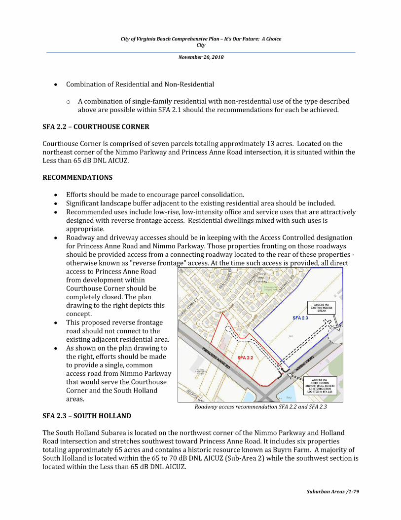
SFA 2.2 – COURTHOUSE CORNER Courthouse Corner is comprised of seven parcels totaling approximately 13 acres. Located on the northeast corner of the Nimmo Parkway and Princess Anne Road intersection, it is situated within the Less than 65 dB DNL AICUZ. RECOMMENDATIONS
Efforts should be made to encourage parcel consolidation. Significant landscape buffer adjacent to the existing residential area should be included. Recommended uses include low-rise, low-intensity office and service uses that are attractively
designed with reverse frontage access. Residential dwellings mixed with such uses is appropriate.
Roadway and driveway accesses should be in keeping with the Access Controlled designation for Princess Anne Road and Nimmo Parkway. Those properties fronting on those roadways should be provided access from a connecting roadway located to the rear of these properties - otherwise known as "reverse frontage" access. At the time such access is provided, all direct access to Princess Anne Road from development within Courthouse Corner should be completely closed. The plan drawing to the right depicts this concept.
This proposed reverse frontage road should not connect to the existing adjacent residential area.
As shown on the plan drawing to the right, efforts should be made to provide a single, common access road from Nimmo Parkway that would serve the Courthouse Corner and the South Holland areas.
SFA 2.3 – SOUTH HOLLAND The South Holland Subarea is located on the northwest corner of the Nimmo Parkway and Holland Road intersection and stretches southwest toward Princess Anne Road. It includes six properties totaling approximately 65 acres and contains a historic resource known as Buyrn Farm. A majority of South Holland is located within the 65 to 70 dB DNL AICUZ (Sub-Area 2) while the southwest section is located within the Less than 65 dB DNL AICUZ.
Roadway access recommendation SFA 2.2 and SFA 2.3

City of Virginia Beach Comprehensive Plan – It’s Our Future: A Choice City
November 20, 2018
Suburban Areas /1-80
RECOMMENDATIONS
Single-family residential development with an overall maximum density consistent with the AICUZ Overlay Ordinance, but not to exceed four units per acre.
A limited range of residentially compatible neighborhood-serving specialty retail shops, office, and service uses may be allowed. Examples of limited neighborhood service uses are day care centers, medical offices, pharmacies, and similar non-intrusive uses.
Efforts should be made to create a single, common access road from Nimmo Parkway to serve Courthouse Corner and South Holland (as shown on map above).
No roadway access should be provided to the existing adjacent residential area, Princess Anne Crossing, from the South Holland Subarea.

City of Virginia Beach Comprehensive Plan – It’s Our Future: A Choice City
November 20, 2018
Suburban Areas /1-81
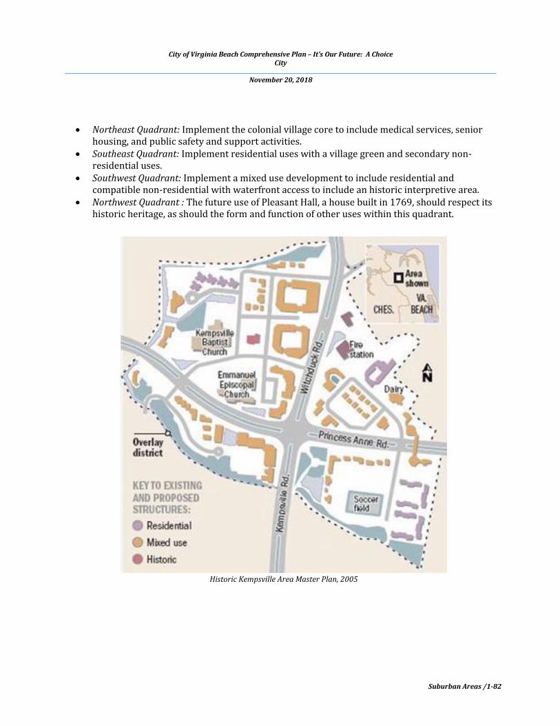
SFA 3 – HISTORIC KEMPSVILLE AREA
DESCRIPTION Following considerable public involvement, the City Council adopted the Historic Kempsville Area Master Plan in January of 2006. This plan outlines the methods needed to implement land use, environmental, transportation and design improvements to accomplish the desired revitalization of this area. It also provides guidance to leverage public investments to achieve multiple outcomes and create a high quality ‘village’ center. The Historic Kempsville Area Master Plan is available in the online document library at www.vbgov.com/Planning. RECOMMENDATIONS Adhere to the Vision and Goals cited in the Historic Kempsville Area Master Plan especially as they relate to the protection of adjoining stable neighborhoods. The following summarizes the master plan’s provisions for each of the quadrants around the realigned Princess Anne/ Witchduck Road intersection:
City of Virginia Beach Comprehensive Plan – It’s Our Future: A Choice City
November 20, 2018
Suburban Areas /1-82
Northeast Quadrant: Implement the colonial village core to include medical services, senior
housing, and public safety and support activities. Southeast Quadrant: Implement residential uses with a village green and secondary non-
residential uses. Southwest Quadrant: Implement a mixed use development to include residential and
compatible non-residential with waterfront access to include an historic interpretive area. Northwest Quadrant : The future use of Pleasant Hall, a house built in 1769, should respect its
historic heritage, as should the form and function of other uses within this quadrant.
Historic Kempsville Area Master Plan, 2005

City of Virginia Beach Comprehensive Plan – It’s Our Future: A Choice City
November 20, 2018
Suburban Areas /1-83
SFA 4 - VIRGINIA AQUARIUM AND OWLS CREEK AREA
DESCRIPTION The Virginia Aquarium and Owls Creek area is generally bound by General Booth Boulevard and South Birdneck Road on the south and east and by property owned by the United States to the north. This area has great potential to be a national example of sustainable growth and economic development geared towards environmental preservation. With a vision supported by the community, the Virginia Aquarium and Owls Creek Area Master Plan (https://www.vbgov.com/government/departments/sga/projects/oc/oc-masterPlanNov2011.pdf) encourages development or redevelopment of regional significance by protecting the natural environment, facilitating a mix of connectivity, enhancing the character, and providing incentives for quality development.

City of Virginia Beach Comprehensive Plan – It’s Our Future: A Choice City
November 20, 2018
Suburban Areas /1-84
RECOMMENDATIONS FOR VIRGINIA AQUARIUM AND RESEARCH CENTER AREA The Virginia Aquarium and Research Area is planned to create expansion opportunities focusing on environmental education, stewardship, and research. The master plan for the aquarium area includes:
New aquarium exhibit building linked to the existing aquarium to provide additional space for exhibits, banquet facilities, and meeting rooms to position the Virginia Aquarium alongside the top tier aquariums in the world.
A research aquarium serving multiple functions diversifying the base of economic activity in the aquarium area, creating a hub of marine science and “green” research and innovation.
The existing boat ramp will remain serving the public, the aquarium, and the green research building.
A green research building will provide space for environmental and energy related research.
RECOMMENDATIONS FOR THE RESEARCH CENTER AT OWLS CREEK POINT AND MARSHVIEW
PROPERTY The Research Center at Owls Creek Point and Marshview Property is a low-impact development that is a supportive extension of the research complex located primarily in the Aquarium area. This development includes additional research space and research-oriented conferencing and symposia space such as:
A natural setting for research, learning laboratories, and small research-oriented meetings and events to attract a niche audience.
The trail system links to the overall trail system throughout the nature park on the Marshview property.
The property will offer to nearby residents, amenities including open nature trails, lookout-towers, boardwalks, open play recreational fields, and possibly a dog park.
Concept for the Research Center
Virginia Aquarium and Research Area Concept
City of Virginia Beach Comprehensive Plan – It’s Our Future: A Choice City
November 20, 2018
Suburban Areas /1-85
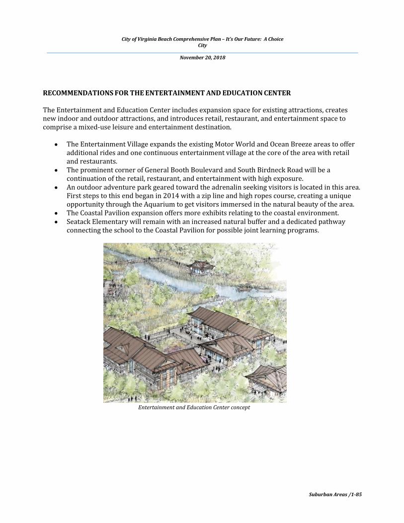
RECOMMENDATIONS FOR THE ENTERTAINMENT AND EDUCATION CENTER The Entertainment and Education Center includes expansion space for existing attractions, creates new indoor and outdoor attractions, and introduces retail, restaurant, and entertainment space to comprise a mixed-use leisure and entertainment destination.
The Entertainment Village expands the existing Motor World and Ocean Breeze areas to offer additional rides and one continuous entertainment village at the core of the area with retail and restaurants.
The prominent corner of General Booth Boulevard and South Birdneck Road will be a continuation of the retail, restaurant, and entertainment with high exposure.
An outdoor adventure park geared toward the adrenalin seeking visitors is located in this area. First steps to this end began in 2014 with a zip line and high ropes course, creating a unique opportunity through the Aquarium to get visitors immersed in the natural beauty of the area.
The Coastal Pavilion expansion offers more exhibits relating to the coastal environment. Seatack Elementary will remain with an increased natural buffer and a dedicated pathway
connecting the school to the Coastal Pavilion for possible joint learning programs.
Entertainment and Education Center concept

City of Virginia Beach Comprehensive Plan – It’s Our Future: A Choice City
November 20, 2018
Suburban Areas /1-86
SFA 4.1 - GENERAL BOOTH CAMPGROUNDS
DESCRIPTION The Holiday Trav-L Park is located on the west side of General Booth Boulevard and the KOA Campground on the east side. Both offer outdoor recreational activities for citizens and visitors of Virginia Beach and complement our City’s recreational programs and the resort hospitality industry. RECOMMENDATIONS
The existing campgrounds offer outdoor recreational activities for both citizens and visitors of Virginia Beach and are appropriate uses for these sites.
Where consistent with AICUZ policy, alternate uses may include attractive, high quality, and low intensity: o Offices;

City of Virginia Beach Comprehensive Plan – It’s Our Future: A Choice City
November 20, 2018
Suburban Areas /1-87
o Resort oriented retail; o Resort oriented recreational; or o Other AICUZ compatible uses
Residential or hotel uses are not recommended for either campground site.
City of Virginia Beach Comprehensive Plan – It’s Our Future: A Choice City
November 20, 2018
Suburban Areas /1-88
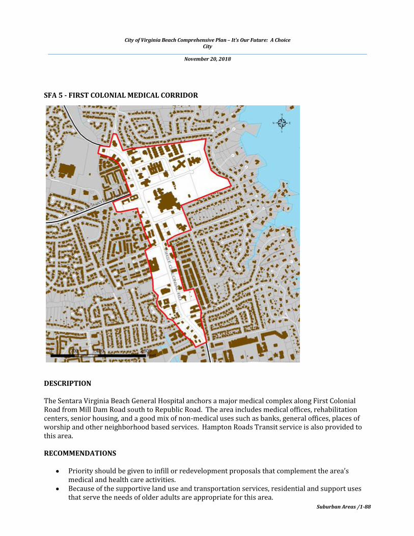
SFA 5 - FIRST COLONIAL MEDICAL CORRIDOR
DESCRIPTION The Sentara Virginia Beach General Hospital anchors a major medical complex along First Colonial Road from Mill Dam Road south to Republic Road. The area includes medical offices, rehabilitation centers, senior housing, and a good mix of non-medical uses such as banks, general offices, places of worship and other neighborhood based services. Hampton Roads Transit service is also provided to this area. RECOMMENDATIONS
Priority should be given to infill or redevelopment proposals that complement the area’s medical and health care activities.
Because of the supportive land use and transportation services, residential and support uses that serve the needs of older adults are appropriate for this area.

City of Virginia Beach Comprehensive Plan – It’s Our Future: A Choice City
November 20, 2018
Suburban Areas /1-89
New development should include access management and cross-access between parcels to minimize impacts to First Colonial Road.
Sentara Virginia Beach General Hospital
City of Virginia Beach Comprehensive Plan – It’s Our Future: A Choice City
November 20, 2018
Suburban Areas /1-90
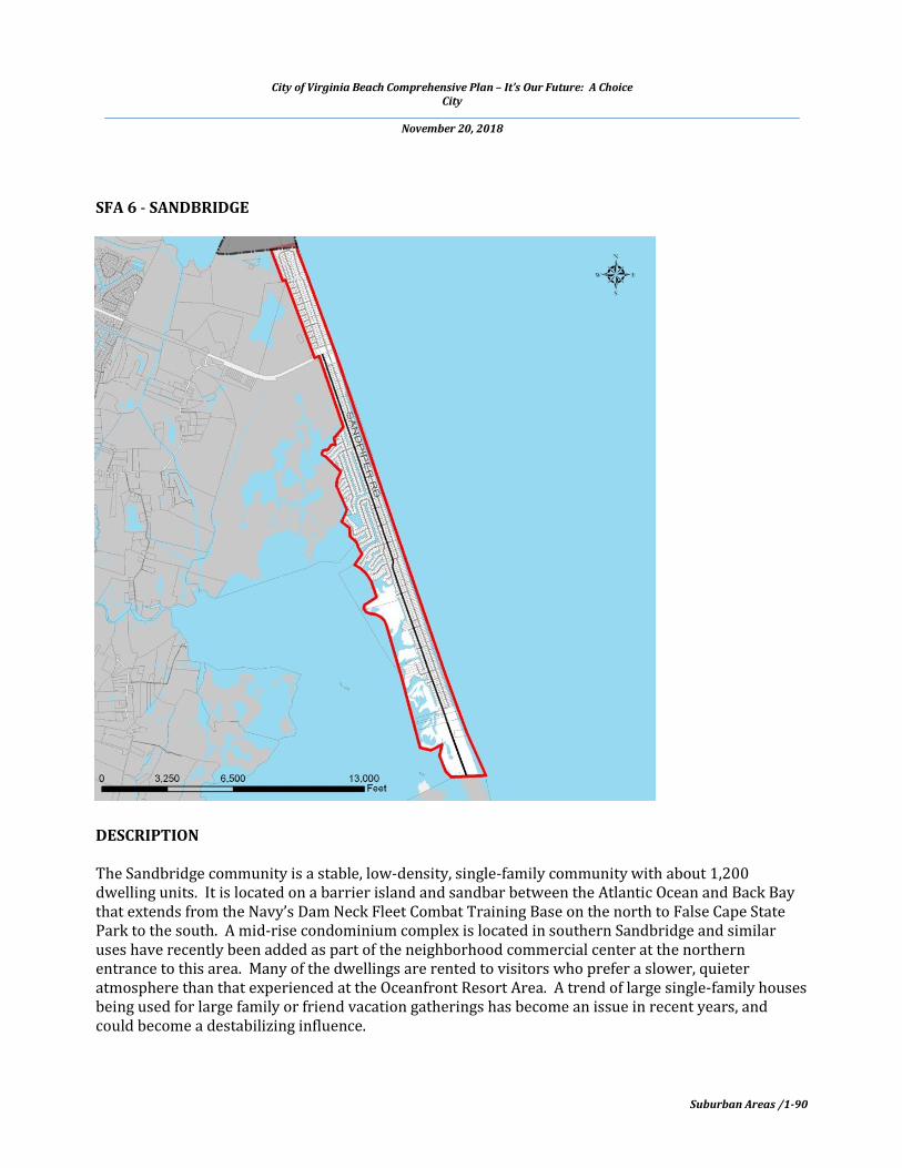
SFA 6 - SANDBRIDGE
DESCRIPTION The Sandbridge community is a stable, low-density, single-family community with about 1,200 dwelling units. It is located on a barrier island and sandbar between the Atlantic Ocean and Back Bay that extends from the Navy’s Dam Neck Fleet Combat Training Base on the north to False Cape State Park to the south. A mid-rise condominium complex is located in southern Sandbridge and similar uses have recently been added as part of the neighborhood commercial center at the northern entrance to this area. Many of the dwellings are rented to visitors who prefer a slower, quieter atmosphere than that experienced at the Oceanfront Resort Area. A trend of large single-family houses being used for large family or friend vacation gatherings has become an issue in recent years, and could become a destabilizing influence.
City of Virginia Beach Comprehensive Plan – It’s Our Future: A Choice City
November 20, 2018
Suburban Areas /1-91
RECOMMENDATIONS It is the policy of the City to retain the existing, low density neighborhood character of Sandbridge. The following land use recommendations apply to this area:
Limited commercial uses may be added provided the type and extent of such uses are scaled to serve only the Sandbridge neighborhood and that the site and building designs are of high quality and consistent with physical characteristics of the neighborhood.
Where opportunities present themselves, consider placing overhead utilities underground. Additional public parking and day use facilities should be provided to serve day visitors. Land uses in the Sandbridge community should be compatible with the environmental
objectives of the Back Bay National Wildlife Refuge. The City and US Navy should continue their long-standing arrangement of providing, when
necessary, an emergency public evacuation route from Sandpiper Road north through NAS Oceana Dam Neck Annex to Dam Neck Road.
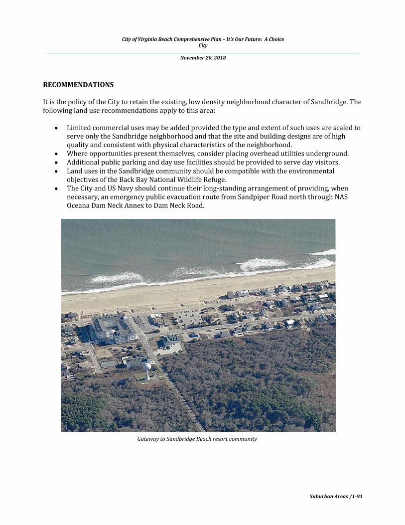
Gateway to Sandbridge Beach resort community
City of Virginia Beach Comprehensive Plan – It’s Our Future: A Choice City
November 20, 2018
Suburban Areas /1-92
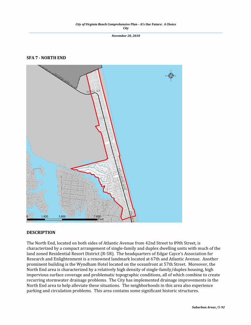
SFA 7 - NORTH END
DESCRIPTION The North End, located on both sides of Atlantic Avenue from 42nd Street to 89th Street, is characterized by a compact arrangement of single-family and duplex dwelling units with much of the land zoned Residential Resort District (R-5R). The headquarters of Edgar Cayce’s Association for Research and Enlightenment is a renowned landmark located at 67th and Atlantic Avenue. Another prominent building is the Wyndham Hotel located on the oceanfront at 57th Street. Moreover, the North End area is characterized by a relatively high density of single-family/duplex housing, high impervious surface coverage and problematic topographic conditions, all of which combine to create recurring stormwater drainage problems. The City has implemented drainage improvements in the North End area to help alleviate these situations. The neighborhoods in this area also experience parking and circulation problems. This area contains some significant historic structures.

City of Virginia Beach Comprehensive Plan – It’s Our Future: A Choice City
November 20, 2018
Suburban Areas /1-93
RECOMMENDATIONS
Parcel consolidation, density stabilization and the use of ‘Best Management Practices’ for stormwater control should be part of reconstruction efforts.
Improvement and reconstruction should use porous materials for driveways, walkways and other similar surfaces, wherever feasible, to achieve a net reduction of impervious coverage.
Attractive and high quality materials capable of withstanding severe weather events should be used.
It is the policy of the city to preserve designated historic structures and efforts to retain these resources should be accomplished in a responsible and innovative manner.
Edgar Cayce's Association for Research and Enlightenment and adjacent private homes

City of Virginia Beach Comprehensive Plan – It’s Our Future: A Choice City
November 20, 2018
Suburban Areas /1-94
SFA 8 - MILITARY HIGHWAY CORRIDOR
DESCRIPTION The general pattern of land uses along this one and one half mile corridor has remained essentially unchanged for decades. To the west is a low to medium density residential area and to the east are light industrial uses including auto and truck sales, rentals, and repairs, outdoor storage, and warehousing. Behind this industrial strip of land are Riverton and Lakeville Estates, both low-density, single-family residential neighborhoods. The Jonathan Cove neighborhood is located on the Elizabeth River north of the industrial area. An established neighborhood, West View Village, is located north of Indian River Road and west of the industrial uses on Military Highway. The land along Military Highway south of Indian River Road is used and zoned for commercial purposes.

City of Virginia Beach Comprehensive Plan – It’s Our Future: A Choice City
November 20, 2018
Suburban Areas /1-95
RECOMMENDATIONS
Replace the industrial activities with more compatible uses such as medium density residential, office, hotel, and institutional uses.
Any change of land use in this corridor located near or adjacent to existing stable neighborhoods must be compatible uses, and employ appropriate buffering features to protect the quality of life of those residential areas.
The number of access points along Military Highway should be significantly reduced. Greater reliance on access management, inter-parcel access, and shared parking between uses is strongly recommended.
New and redeveloped uses should improve the aesthetic of this corridor through high quality building design, signage and landscaping.
All major land use changes considered for this area should be coordinated with the Cities of Chesapeake and Norfolk.
Intersection of Military Highway and Providence Road (looking north) [photo ©2016 Google Earth]

City of Virginia Beach Comprehensive Plan – It’s Our Future: A Choice City
November 20, 2018
Suburban Areas /1-96
SFA 9 - HISTORIC SEATACK SFA & HISTORIC SEATACK COMMUNITY

City of Virginia Beach Comprehensive Plan – It’s Our Future: A Choice City
November 20, 2018
Suburban Areas /1-97
DESCRIPTION
The Historic Seatack community, located in the City’s Oceanfront Resort Area, is thought to be the
oldest African-American settlement in Virginia and possibly in the United States. Outlined by the
dashed black line on the above map, it is generally centered on the Birdneck Road corridor between
Old Virginia Beach Road and Bells Road, on Virginia Beach Boulevard between West Lane and the
convention center area, and along Southern Boulevard/Norfolk Avenue, and includes the area of
Atlantic Park. It is bounded on the east by Lake Rudee, Owls Creek, and the Marshview Park area and
on the west by the Oceana Gardens Neighborhood and the industrial and residential areas just east of
NAS Oceana. The original settlement, which was once much larger extending to the present day
Virginia Beach oceanfront, was formed by free men and dates back to the late 1700s to early 1800s.
The area eventually took its name from the words “Sea Attack,” based on British warship cannons
positioned off the Virginia Beach shoreline that fired inland during the War of 1812. A more detailed
accounting of the Seatack community’s history is located in the Technical Report.
Seatack is an integral part of the Resort Area and, while primarily a residential community with
supporting religious institutions and public facilities, such as a neighborhood park and recreation
center, it also includes some businesses and light industry. With the improvement of Birdneck Road,
this area is now well-served by a strategically located transportation corridor.
Much of the SFA is constrained by the Special Flood Hazard Area, is owned by the Federal Government
or has Navy restrictive easements, is impacted by military aircraft accident potential zones (APZ-1 and
APZ-2) and the highest noise zones (70 – 75 dB DNL and greater than 75 dB DNL). Per market trends
and the requirements of Article 18, Special Regulations in Air Installations Compatible Use Zones
(AICUZ) Overlay, new development and redevelopment of property within the SFA has occurred with
uses compatible with flight operations at nearby NAS Oceana. In some cases, this development
activity has altered the character of this historic community.
The SFA is in a flat, low-lying area in proximity to waterways and wetland areas in the Lynnhaven
River system and the Owls Creek watershed. Drainage issues and recurrent flooding, especially
associated with new development, have been observed which has, in some cases, negatively impacted
existing residential areas.
There are several significant historic and cultural landmarks in this SFA that are important to the
history and progress of the community. They should be recognized and/or protected as local historic
or cultural landmarks. There may be opportunities to place historical markers at some of these sites
and/or have them included on the Virginia Beach Historic Register through nomination by the
property owners.
The recommendations for the Historic Seatack SFA are found below and are focused on the properties
encompassed by the solid red line on the above map.

City of Virginia Beach Comprehensive Plan – It’s Our Future: A Choice City
November 20, 2018
Suburban Areas /1-98
RECOMMENDATIONS
1. All new development, redevelopment and additions to structures should adhere to the City
Zoning Ordinance requirements established in Article 18, Special Regulations in Air
Installations Compatible Use Zones (AICUZ) Overlay.
2. All new development, redevelopment and additions to structures, will, as required, adhere to
the requirements of Code of Virginia Beach, Appendix I, Airport Noise Attenuation and Safety
Ordinance.
3. New development should respect the historic settlement of this area and should be compatible
with the neighborhood. Significant landscape screening buffers should be established between
existing residential areas and new non-residential development to mitigate adverse visual and
noise impacts.
4. A careful mix of compatible land uses should be maintained where they currently exist and
should be encouraged as new land uses are proposed so as to contribute to the day-to-day life
of community residents.
5. Uses incompatible with existing residential should be discouraged to minimize impact to
adjacent residential neighborhoods.
6. Building design should be visually interesting, encourage greater social interaction, and
provide a memorable character.
7. Neighborhood identification signs should be installed at neighborhood entrances/gateways.
8. Recognition of historic and cultural landmarks and sites should be encouraged by nomination
to the Virginia Beach Historical Register or and/or by the installation of interpretive historic
site markers.
9. In partnership with and guidance from the Seatack Community, explore the potential benefits
and regulatory impacts of delineation and adoption of a local Historic and Cultural District, if
desired by the community and property owners.
10. All new development should be designed such that site drainage and stormwater management
does not negatively impact adjacent parcels.
11. Maintain stormwater facilities and encourage the retrofit of existing drainage system problem
areas.
City of Virginia Beach Comprehensive Plan – It’s Our Future: A Choice City
November 20, 2018
Suburban Areas /1-99
12. New development, redevelopment, and site improvements should be encouraged to use porous
materials for driveways, walkways and other similar surfaces, wherever feasible, to achieve a
net reduction in impervious coverage.
13. Enhance landscaping in the Birdneck Road medians where there are opportunities to do so.
14. The Virginia Aquarium and City’s Marshview Park improvement projects should provide
education and recreation opportunities for Seatack residents through neighborhood outreach
programs.
15. New development and public facilities improvements should accommodate multiple modes of
transportation (e.g. pedestrians, bicyclists, and drivers) and accessibility needs.
AGENDA FOR FUTURE ACTION RECOMMENDATIONS: Suburban Area
Develop infill development guidelines as a component of the “Special Area Development Guidelines: Suburban Area” in the Reference Handbook.
Develop tools to encourage new investment in declining commercial centers. Develop tools to assist distressed property owner associations with the preservation and
maintenance of neighborhood parks and open spaces. Revise the Suburban Area section of the Comprehensive Plan as appropriate when sea level
rise and recurrent flooding policies are developed and/or adopted by the City Council. To ensure that the function of Princess Anne Road is not reduced due to numerous access
points within Suburban Focus Area 2.1 (North Courthouse), the City should construct all or a portion of at least two lanes of London Bridge/Drakesmile Extended.
Study the area between Holly Road and Pacific Avenue, north of 32nd Street to 42nd Street (the southern boundary of North End SFA) to determine need for infill development and redevelopment policies and design guidelines.