Embed Size (px)
Citation preview

International Journal on Emerging Technologies 7(1): 732-740(2016)
ISSN No. (Print) : 0975-8364
ISSN No. (Online) : 2249-3255
Redevelopment as a development strategy: A critical analysis. Case study Vinod Nagar, Delhi
Sumedha Jain* and Vanita Verma** *Assistant Professor, Sushant School of Art and Architecture
**Independent Urban Designer, Researcher
(Corresponding author: Sumedha Jain)
(Received 06 January, 2017 Accepted 29 January, 2017)
(Published by Research Trend, Website: www.researchtrend.net)
ABSTRACT: Delhi has a significant history and housing has been a critical aspect that has defined the city
form through time. Housing of the masses is now among the foremost issues that city has been grappling. The
rapid pace of evolution of this typology of housing suggests a favorable demand trend of this kind of housing.
This housing texture of this housing type is synonymous with a characters of built environment like ‘organic
growth’ ,high density, narrow lanes, small plots, high ground coverage and structures of about 3-4 floors
height, mixed land use and a general deficiency of infrastructure. Often outside the ambit of the planned and
perceived as chaotic, these locations are then categorized as the “informal, unregulated and unplanned
“which are deficient in services and unfit for habitation. The city administration and growth regulators from
time to time attempted to find formal solutions like redevelopment for such reorganizing these housing
chunks. The Delhi master plan 2021 encourages redevelopment as a developmental policy and details an
entire chapter on the possible clauses that could be adopted for a redevelopment exercise. Our investigations into the nature of these settlements reveal existence of evolved and established social and economic networks
and an equilibrium between life styles and aspirations of the people. We through our paper wish to critically
evaluate the suitability of redevelopment as a process in such a scenario. The essential question that we intend
to pose is – Is redevelopment the right solution for organic Delhi? Our paper would attempt to understand
redevelopment through study of Vinod Nagar (a combination of unauthorized, unauthorized regularized and
an urban village) located in East Delhi.
Some of the questions that we wish to explore are:
• Understanding the context of Vinod Nagar (social and economic profile) and Its connection to the city.
• Understanding of the policy of redevelopment in context of Delhi.
• Imagining redevelopment against the context of Vinod Nagar and critical analysis of the outcome.
I. UNDERSTANDING ASPECTS OF VINOD
NAGAR The spread of unauthorized construction in our cities
has assumed significant proportions. It is estimated that
in Delhi, the population resident in unauthorized
colonies (a type of unauthorized construction) is over 4
million. The government, of the National Capital
Territory of Delhi under the 2021 master plan
guidelines has issued ‘provisional regularization’
certificates to 1,639 unauthorized colonies to start the process of redevelopment/renewal/regularization of the
colonies. The objective of this is to bring them into the
urban mainstream. However, the morphology and urban
structure of these colonies is different from the
‘greenfield’ planned development guided by the Delhi
Master Plan.(ASHISH GANJU, 2014). To represent a
case, and to understand the context of these colonies,
the paper has taken up the study of Vinod Nagar, an
unauthorized development in East Delhi.
II. LOCATION AND LEGAL STATUS
Initially Vinod Nagar was a small village of Mandawali
that lay across Yamuna in East Delhi. During the
process of expansion of boundaries of Delhi, urban villages were absorbed and the agricultural lands were
acquired by the DDA. Unplanned / unauthorized /
Regularized colonies are typologies that emerged when
the acquired agricultural lands were illegally cut into
parcels and offered to people for development.
et
Jain and Verma 733
A few years back a part of Vinod Nagar was
regularized. Regularization is about recognition of
ownership rights of residents in the area. Regularization also legally makes a colony a legal part of city
development process. However larger parts of Vinod
Nagar are still unauthorized. The area thus is an apt
example to represent the unauthorized colonies in the
city.
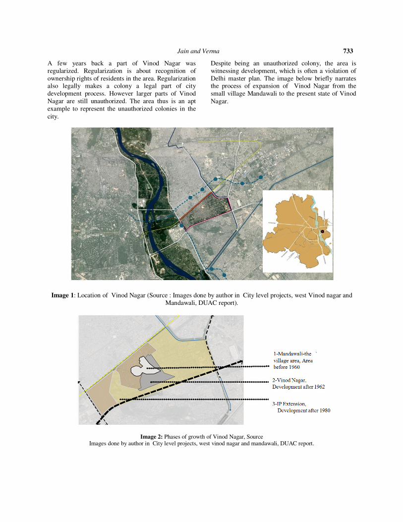
Despite being an unauthorized colony, the area is
witnessing development, which is often a violation of
Delhi master plan. The image below briefly narrates the process of expansion of Vinod Nagar from the
small village Mandawali to the present state of Vinod
Nagar.
Image 1: Location of Vinod Nagar (Source : Images done by author in City level projects, west Vinod nagar and
Mandawali, DUAC report).
Image 2: Phases of growth of Vinod Nagar, Source Images done by author in City level projects, west vinod nagar and mandawali, DUAC report.

Jain and Verma 734
III. GROWTH AND EXPANSION
Image 3: Landuse distribution of Vinod Nagar. Image 4: Range of densities existing across various
colonies in Vinod Nagar, Source : Images done by
author in City level projects, west vinod nagar and
mandawali, DUAC report
Due to locational advantages like proximity to NH-24
and the planned areas of Patpargunj and IP Extension, Vinod Nagar is becoming a favorable residential
destination. The area has witnessed a consistent
increase in density in terms of PPHA with a single plot
being divided into a number of dwelling units. The following image demonstrates the densification of
Vinod Nagar between 1980 and 2013.
Image 5: Growth of built form in a colony in Vinod Nagar, Image 6a,6b,6c : Photos of Vinod Nagar,Source : Images done by author in City level projects, west vinod nagar and mandawali, DUAC report.
Jain and Verma 735
The area has grown in terms of density in various ways.
Reduction of plot sizes, Subdivision of bigger plots
into smaller ones, encroachment on roads and open spaces are ways used by residents to increase built-up
areas.The densities of Vinod Nagar colonies range
between 600 people /ha to 1400 ppha.When the existing
land use was compared to that suggested by masterplan,
the following was the analysis:
1. 56% land was under residential use.
2. The area of convenience shopping existing on
site exceeded master plan numbers by six
times.
3. The area of study had 65% shortage in
neighborhood greens but an excess of 11.4% of community parks.
4. The area under study had sufficient schools in
comparison to standards prescribed by MPD
but lacked in primary schools (with a deficit of 82%)
5. The area of study has no bedded hospitals and
lacks in facilities like Dispensary with almost
71.6 % deficit.
To sum up, the area fell short in healthcare and
education facilities, while the commercial and
residential components exceed the limits prescribed by
the master plan. With growing population the area will
increasingly fall short in terms of health and education
facilities.
.
Image 6: The ward boundaries within Vinod Nagar. Image 7: Location of
unauthorized sett lements
in Delhi, Source.
Images done by author in City level projects, west vinod nagar and mandawali, DUAC report
Mandawali is an urban village with a defined legal
boundary. Vinod Nagar consists of colonies which
are a combination of Unauthorized, Unauthorized
Regularized and slum. “Unauthorized colonies in Delhi have been in existence right from the time the
planned development of Delhi started with the
setting-up of DDA in 1957, Since DDA was unable
to construct enough low cost housing and there was
large scale migration from neighboring states. It is
estimated that about 7.00 lakh families are residing in
these unauthorized colonies. (Source, DDA website).
Because of their unplanned and spontaneous nature
they could not be covered under the ambit of
masterplan legality and therefore couldn’t be
assigned any legal status. All these areas face common issues like absolute shortage of open spaces
within the colony, lack of healthcare facilities,
chaotic and unorganized mobility, inefficient storm
water management and lack of water conservation,
growing mixed use in the area and higher densities
than anticipated and smaller plot sizes.
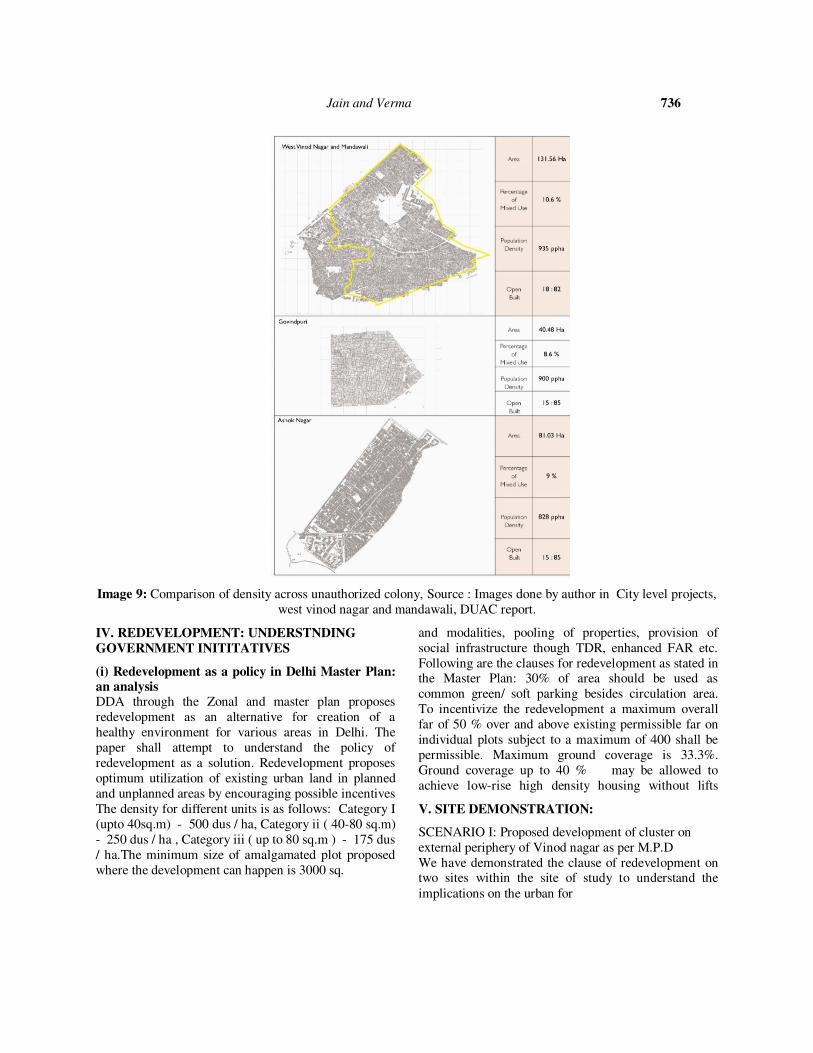
Jain and Verma 736
Image 9: Comparison of density across unauthorized colony, Source : Images done by author in City level projects,
west vinod nagar and mandawali, DUAC report.
IV. REDEVELOPMENT: UNDERSTNDING
GOVERNMENT INITITATIVES
(i) Redevelopment as a policy in Delhi Master Plan: an analysis DDA through the Zonal and master plan proposes
redevelopment as an alternative for creation of a
healthy environment for various areas in Delhi. The
paper shall attempt to understand the policy of
redevelopment as a solution. Redevelopment proposes
optimum utilization of existing urban land in planned
and unplanned areas by encouraging possible incentives
and modalities, pooling of properties, provision of
social infrastructure though TDR, enhanced FAR etc.
Following are the clauses for redevelopment as stated in the Master Plan: 30% of area should be used as
common green/ soft parking besides circulation area.
To incentivize the redevelopment a maximum overall
far of 50 % over and above existing permissible far on
individual plots subject to a maximum of 400 shall be
permissible. Maximum ground coverage is 33.3%.
Ground coverage up to 40 % may be allowed to
achieve low-rise high density housing without lifts
The density for different units is as follows: Category I
(upto 40sq.m) - 500 dus / ha, Category ii ( 40-80 sq.m)
- 250 dus / ha , Category iii ( up to 80 sq.m ) - 175 dus
/ ha.The minimum size of amalgamated plot proposed
where the development can happen is 3000 sq.
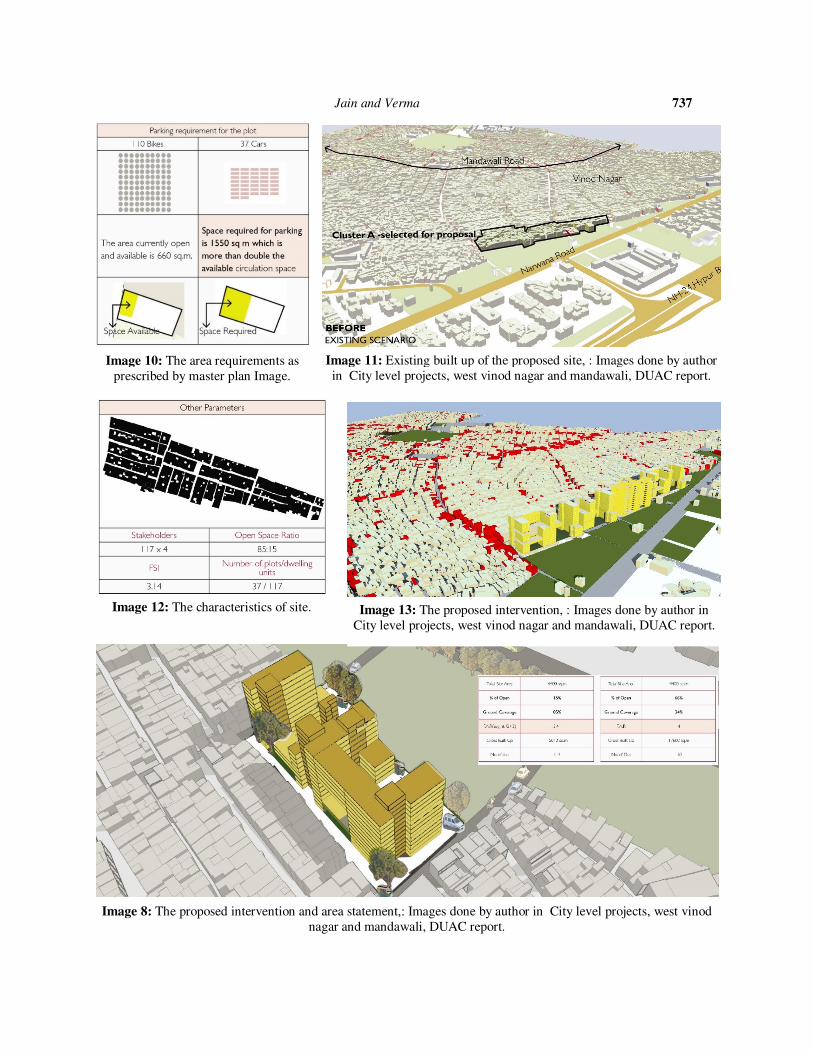
V. SITE DEMONSTRATION:
SCENARIO I: Proposed development of cluster on
external periphery of Vinod nagar as per M.P.D
We have demonstrated the clause of redevelopment on two sites within the site of study to understand the
implications on the urban for
Jain and Verma 737
Image 8: The proposed intervention and area statement,: Images done by author in City level projects, west vinod
nagar and mandawali, DUAC report.
Image 10: The area requirements as
prescribed by master plan Image.
Image 11: Existing built up of the proposed site, : Images done by author
in City level projects, west vinod nagar and mandawali, DUAC report.
Image 12: The characteristics of site. Image 13: The proposed intervention, : Images done by author in
City level projects, west vinod nagar and mandawali, DUAC report.

Jain and Verma 738
By MPD standards maximum ground coverage is 33.3% Ground coverage up to 40 % may be allowed to achieve
low-rise high density housing without elevators.
SCENARIO II:Proposed Development of 3000 sq.m cluster within Vinod Nagar
Image16: Area calculation for option 2. Image 17: The proposed intervention.
Image 15: Next page, plan of the proposed intervention.
Image 18: Existing Site context for Scenario 2. Image 19: Proposed intervention for Scenario 2
Images done by author in City level projects, west
vinod nagar and mandawali, DUAC report.

Jain and Verma 739
Image 9: The proposals in the context of Vinod Nagar.
Source : Images done by author in City level projects, west Vinod nagar and mandawali, DUAC report.
VI. ANALYSIS
A process of this kind has advantages like optimal
utilization of land, provision for facilities/amenities,
ordered traffic movement and parking spaces .However
there are some critical questions: Unauthorized colonies like Vinod Nagar have small plots and many owners. Its
only an assumption that the people residing in this area
are low income. As stated earlier, these locations
because of their proximity to amenities are now sought
after residential locality. The development of Vinod
Nagar (typical of most such colonies) reflects an
equilibrium attained w.r.t. life styles and aspirations of
the people. Would redevelopment justify negating the
investment the residents have made in the present
development? A plot amalgamation exercise would
require active participation of all owners and residents.
In this situation approx. 1800 owners of MIG would be
involved. Who, then would be entrusted with the
ownership of implementation of development on this
scale? Who would finance it and why?
Apart from the complexities in decision of an ideal model, our experience with people’s participation
suggests that people prefer provision of facilities and
amenities than the condition of the housing. Due to
their location and access to facilities these spaces are
preferred rental destinations.
The policy of regularization is thus still a very unclear.
We suggest an immediate focus on small but effective
schemes should be placed on small yet effective
schemes that would help in overall upgradation of the
area.

Jain and Verma 740
REFERENCES
The above presented case is a site based study done by author
[1]. ASHISH GANJU, J. M. (2014). LOCAL AREA
PLANNING-AYA NAGAR. Delhi: Delhi Urban Art Comission.