Embed Size (px)
Citation preview

Grosse Ile Open Space Locations & Trail GuidePrepared by the Grosse Ile Open Space/Greenways Committee
Updated July 2012
The residents of Grosse Ile possess a natural public treasure by preserving undeveloped land. Currentand future residents live among Michigan’s natural heritage, which include native hardwood forests.Open Space properties are aquired for the purpose of preservation with the intention they remain as natural woodlands, wetlands, habitats for native flora and fauna, and free from the impacts of intrudingdevelopment. As of 2012, 519 acres have been preserved as a result of the program. Your Open SpaceCommittee is a group of volunteers who are charged by the township to maintain the natural beautyof our Island community.
To aid in your enjoyment of this treasure, we have included a map showing the locaton of the OpenSpaces and a guide of three existing trails, plus a fourth trail being planned for completion by the endof this year. There are many other paths, however, that exist as a result of deer travel, old farm trails,and foot traffic.
We hope that you will enjoy walking through the woods and trails, but ask that you respect the privacyof adjacent residents, confine your visits to daylight hours, take nothing but pictures and leave nothing butfootprints. We encourage you to pick up any trash and report unwelcome activities to the township authorities.
Grosse Ile residents are blessed to live in an area surrounded by an abundance of Michigan’s natural heritage treasures. These natural areas include marshes, woodlands, meadows and trails which have been protected to remain in their natural state free from development. As a result, the small town, semi-rural natural ambiance of our community is maintained.
To give you the complete story of this treasure, the guide has been expanded to include a map of all the natural areas which include the Open Spaces purchased by the Township and overseen by the Open Space Committee, the natural areas purchased by or donated to the Grosse Ile Nature & Land Conservancy (GINLC), and land owned by the state and federal governments.
The total protected area includes 566 acres of Grosse Ile Open Space, all on the main island, the GINLC’s 41 acres on Grosse Ile and 121 acres of marsh land and stewarded easements, nearly 365 acres of the Michigan Dept. of Natural Resources islands, and 80 acres owned by the Detroit River International Wildlife Refuge (DRIWR).
Pages 2 and 3 contain a map showing the location of all the areas mentioned above. Pages 4 – 6 and 11 - 13 describe the characteristics of each area referenced on the map. Pages 7 – 10 describe the four official nature trails established by the Open Space Committee. There are also many other trails in the natural areas as a result of wildlife traffic, old farm paths and foot traffic. Pages 14 and 15 contain the history and organization of the Open Space Program and the GINLC. Finally, page 16 gives you a brief list of the natural beauties you may see on Grosse Ile.
We hope you will enjoy walking through the woods, trails and easements, and viewing the marshes. We also hope you will respect the privacy of adjacent residents, confine your visits to daylight hours, take nothing but pictures and leave nothing but footprints.
A Guide to the Natural Areas of Grosse IlePrepared by the Grosse Ile Open Space Greenways Committee and
Grosse Ile Nature and Land ConservancyUpdated May 2015
12. Parkway WoodsThis 32-acre property is located at the northeast corner of Meridian Road andGrosse Ile Parkway. It frames the Township Public Safety Building complex. Tree Species: sugar maple, ash, red & black oak, hickory, red & silver maple,cottonwood.Wildlife Species: Poison ivy, wild grape, acorns, black walnut, and hickory.There are trail entrances from the Playscape and behind Kroger.
13. Centennial Farm Open Space The 37-acre parcel is located west of the Centennial Farm.Tree Species: red oak, red maple, ash, hickory, elm, soft maple, cottonwood.Wildlife Species: Poison ivy, wild grape, acorns, black walnut, hickory, Virginiacreeper.Noteworthy: A 40-inch red oak tree. There is a trail from the farm into thewoods.
14. Manchester Woods Manchester Woods is bordered on the west by Meridian Rd. and abuts privatehomes between Rucker Ave., Manchester Blvd., and East River Rd. All 153acres are contiguous. Tree Species: red oak, sugar red & silver maple, ash, black walnut, basswood. Wildlife Species: poison ivy, wild grape, acorns.Noteworthy: A 45-inch diameter bur oak. A number of large black walnut,hickory, raspberry, Virginia creeper, white and red oak trees with diametersranging from 30 to 50 inches. With the demand for hardwood lumber, treeswith a diameter greater than 30 inches are rare. There is trail access fromMeridian Road.
15. Recreation Area TrailThis 14-acre parcel is north of the soccer fields and west of Meridian Rd.Tree Species: hawthorn, box elder maple, dogwood, cottonwood, buckthorn,ash, elm, aspen.Wildlife Species: wild grape, raspberry, gray dogwood shrubsThere is a trail access from west of the soccer fields that exits south ofMeridian school on Meridian Road.
16. Loma Circle/Frenchman's CreekThis 15-acre property's east side slopes down to a marsh and Frenchman'sCreek, the western border. Loma Circle East extends across the northwest cor-ner of the property. Tree Species: ash, cottonwood, swamp white oak, elm, box elder maple.Wildlife Species: jewelweed, Joe-pye weed, arrowroot, cattail, ironweed, sting-ing nettles, sedges, purple loose strife, phragmites grass. There is trail access atthe southeast corner of Loma Circle.
17. Groh Road PropertyThis 7-acre property crosses both sides of Frenchman's Creek on the north sideof Groh Road.Tree Species: ash, elm, red mapleWildlife Species: Poison ivy, wild grape. This property is west of the cemetery.
18. Parke Lane Open SpaceParke Lane borders this 10-acre property on the east, Wood Dr. on the south,H.C.L. Jackson Dr. on the west and Horsemill to the north. There is a trailinto the property from Parke Lane.19. York PropertiesThree small areas located north of the Horsemill Greenway.20. Wendell CourtThis 12-acre property borders the west side of Parke Lane near Wendell Court.The property was purchased in 2003 with contributions from adjacent residentsand Open Space funds.21. Korneffel WoodsThis 38-acre property was purchased in 2004. It is located south of BridgeRoad. The west end of the property borders Meridian and the east end isapproximately 300 ft. west of Parke Lane. It is heavily forested, containing ash,maple, and other hardwoods.22. Elba Mar MeadowsThis is a 12-acre parcel, located on East River Road across from the ariport.Trails are planned, entering from East River Road, viewing moored boats andwildlife.

2 3
North Section Middle Section South Section
Tow
nshi
p Pr
oper
ties
Base
d on
a M
arch
26,
201
3 M
ap b
y Ch
arle
s E.
Rai
nes
Com
pany
Upda
ted
by G
INLC
Apr
il 4,
201
5
GRO
SSE
ILE
TOW
NSH
IP N
ATU
RAL
ARE
AS
Stat
e O
wne
d
Fede
ral O
wne
d
GIL
BRAL
TAR
BAY
UN
ITD
ETR
OIT
RIV
ER IN
TER
NAT
ION
AL W
ILD
LIFE
REF
UG
E
GI O
pen
Spac
e/O
wne
d Ar
eas
6 - K
OR
NEF
FEL
WO
OD
S - O
PEN
SPA
CE
7 - T
HE
WIL
DLI
FE S
ANC
TUAR
Y - O
PEN
SPA
CE
8 - E
AST
OF
THE
WIL
DLI
FE S
ANC
TUAR
Y - O
PEN
SPA
CE
9 - P
ARKE
LAN
E O
PEN
SPA
CE
10 -
WEN
DEL
L C
OU
RT
- OPE
N S
PAC
E
19 -
PAR
KWAY
WO
OD
S - O
PEN
SPA
CE
25 -
CEN
TEN
NIA
L FA
RM
& O
PEN
SPA
CE
26 -
MAN
CH
ESTE
R W
OO
DS
- OPE
N S
PAC
E
24 -
GR
OH
RO
AD -
OPE
N S
PAC
E
22 -
LOM
A C
IRC
LE/F
REN
CH
MAN
’S C
REE
K - O
PEN
SPA
CE
21 -
REC
REA
TIO
N A
REA
TR
AIL
- GI P
RO
PER
TY
17 -
GR
AYS
DR
IVE
- OPE
N S
PAC
E
11 -
LOW
RIE
GR
EEN
WAY
- O
PEN
SPA
CE
12 -
MAN
OR
WO
OD
S - O
PEN
SPA
CE
15 -
BIKE
PAT
H P
ARK
- OPE
N S
PAC
E
14 -
ISLA
ND
AVE
NU
E (F
ERR
Y) W
OO
DS
- OPE
N S
PAC
E
5 - H
OR
SEM
ILL
OPE
N S
PAC
E
4 - H
OR
SEM
ILL
GR
EEN
WAY
- O
PEN
SPA
CE
3 - G
RO
SSE
ILE
WO
OD
S - O
PEN
SPA
CE
2 - T
HO
RO
FAR
E R
OAD
- O
PEN
SPA
CE
1 - M
ARIO
N P
ARK
- OPE
N S
PAC
E
28 -
ELBA
MAR
MEA
DO
WS
- OPE
N S
PAC
E
27 -
OLD
ANI M
ARSH
- G
I PR
OPE
RTY
13 -
STO
UT
WO
OD
S - O
PEN
SPA
CE
23 -
INTR
EPID
PO
ND
- G
I PR
OPE
RTY
18 -
MAC
OM
B O
VER
LOO
K
20 -
WAT
ERFR
ON
T PA
RK
29 -
AIR
POR
T N
ATU
RAL
AR
EA -
GI P
RO
PER
TY
16 -
GR
AYS
DR
IVE
EASE
MEN
T (P
UBL
IC)
GIN
LC P
rese
rves
GIN
LC E
asem
ents
A - H
ENN
EPIN
MAR
SH P
RES
ERVE
B - H
ENN
EPIN
MAR
SH G
ATEW
AY
F - C
RYS
LER
EAS
EMEN
T (P
RIV
ATE)
C -
GR
OSS
E IL
E W
OO
DS
PRES
ERVE
S
D -
THO
RO
FAR
E C
ANAL
(KO
BILJ
AK)
PRES
ERVE
R -
FIN
AZZO
PR
ESER
VE
Q -
WR
IGH
T W
OO
DS
PRES
ERVE
(2
2% P
RES
ERVE
, 78%
PR
IVAT
E)
N -
CLE
AVER
PR
ESER
VE
M -
TAYL
OR
PR
ESER
VE
G -
RYD
ER P
RES
ERVE
K - M
LBFT
A PR
ESER
VE
J - W
ITTB
OLD
PR
ESER
VE
I - M
OR
SE P
RES
ERVE
L - D
’AVA
NSO
PR
ESER
VE
P - D
ALY
PRES
ERVE
E - F
INAZ
ZO E
ASEM
ENT
(PR
IVAT
E)
S - E
MIL
Y’S
WAY
H -
CAL
DW
ELL
PRES
ERVE
O -
PAR
KWAY
PR
ESER
VE
HENNEPIN POINT
Priv
ate
& G
INLC
Pre
serv
e

4 5
Open Space GINLC 1. Marion Park – approximately 7 acres bordered by Paulina and Voigt Avenues on the north and south. Noteworthy: 24 and 26-inch diameter black walnut trees and 38 and 48-inch diameter honey locust trees.
A. Hennepin Marsh Preserve -- 121 acre shallow water wetland bordering Detroit River Trenton Channel. Viewing access available through Hennepin Marsh Gateway Preserve.
2. Thorofare Road, west of the Wildlife Sanctuary – 3-acre site slopes down from the higher Wildlife Sanctuary and is bordered to the east by Thorofare Road. Noteworthy: 45-inch diameter Bur Oak near the southwest corner.
B. Hennepin Marsh Gateway – 1.5 acre wooded wetland habitat on Meridian between Annette and Paulina. Property features a short hiking trail with a boardwalk over wetland with a trail continuing to a wildlife observation platform overlooking the Hennepin Marsh. Ecology-related interpretive signs are present at the site.
3. Grosse Ile Woods – a partially protected heavily forested area west of the Wildlife Sanctuary (52 acres of Open Space land and 9 acres owned by GINLC). Thirty-eight acres of vacant private land remain to be purchased.
C. Grosse Ile Woods Preserves – 47 lots comprising a total of 9 acres of excellent wildlife habitat purchased from or donated by six families and the Michigan Land Bank near Horsemill and Thorofare.
4. Horsemill Greenway – 5-acre greenway fronts Horsemill Rd and Horsemill Open Space to the south.
D. Thorofare Canal (Kobiljak) Preserve -- 0.73-acre upland property on Thorofare and Byromar that adjoins the Thorofare Canal. A great deal of effort has been expended by the GINLC to develop a more diverse habitat on the property with the planting of many native trees and shrubs. Contains a butterfly garden.
5. Horsemill Open Space – 31-acre rectangular site is bordered by Horsemill Rd on the north, Meridian Rd on the west, and Thorofare Rd on the east. The site was once farmland and now has a cover of brush and small trees.
E. Finazzo Easement – privately owned 0.85-acre site by Parke Lane and Horsemill is under a conservation easement. Wooded wetland habitat, has experienced a loss of white ash trees due to the Emerald Ash Borer.
6. Korneffel Woods – 38-acre property was purchased in 2004. Located south of Bridge Rd. Bordered by Meridian on the west and the eastern boundary is approx 300 feet east of Parke Lane. It is heavily forested.
F. Ranck (Crysler) Easement – 1-acre parcel, under conservation easement with GINLC, containing wooded wetland habitat, adjacent to Finazzo Easement near Parke Lane and Horsemill.
7. The Wildlife Sanctuary – 12-acre property is bordered by roads on 3 sides, Horsemill (south), Thorofare (west) and Morkland (north). The east side slopes down to the Thorofare Canal. It has been under the stewardship of the Grosse Ile Garden Club since 1943. There is a trail entrance on the north side of Horsemill Rd.
8. East of the Wildlife Sanctuary – 37-acre site is bordered on the west side by Thorofare Canal, on the south by Horsemill Rd, and Parke Lane and private property on the east, and private property on the north. There is a trail entrance north of Horsemill and east of Canal St.
9. Parke Lane Open Space – 10-acre property is bordered by Parke Ln on the east, Wood Dr on the south, HCL Jackson on the west and Horsemill on the north. There is a trail into the site on Parke Lane.
10. Wendell Court – 12-acre property borders the west side of Parke Lane near Wendell Ct. Purchased in 2003 with contributions from adjacent neighbors and Open Space funds.
Special Note:
Hennepin Point -- privately owned by BASF Corporation. The 225-acre site at the northernmost end of Grosse Ile was formerly used by BASF’s predecessor companies as a repository for byproducts from chemical manufacturing. The site has been secured and is being naturally rehabilitated and revegetated under BASF management. The site is not open to the public but will remain as a natural area for use by wildlife and wildlife researchers.
Open Space and GINLC PropertiesNorth Portion (from Hennepin Point to Church Road)
Open Space and GINLC PropertiesMiddle Portion (from Church Road to Bellevue Road)
Open Space GINLC 11. Lowrie Greenway – 0.5-acre greenway located east of Meridian Rd. and northwest of Lowrie Rd.
G. Ryder Preserve – 0.24-acre site near Blauvelt and Lafayette with nice oak tree specimens.
12. Manor Woods – approximately 11-acre triangular shaped parcel is wedged between Meridian Rd, the Thorofare Canal and Waterman Dr.
H-K – Four upland sites bordering Thorofare Canal near Gregory and Marlborough Sts. H. Caldwell Preserve – 0.48-acre, I. Morse Preserve – 0.39 acre, J. Wittbold Preserve – 0.46-acre, K. MLBFTA Preserve – 0.3-acre,
13. Stout Woods – 10-acre heavily wooded site with a natural trail. Entrance from the end of Parke Lane.
L. D’Avanzo Preserve – 4 lots totaling 0.62-acres of mixed habitat bordering the waterway near Halley Crescent & Hickory Circle
14. Island Avenue (Ferry) Woods – 73-acre property parallels Island Avenue between the Thorofare Canal and E. River Rd.
M. Taylor Preserve – 0.53 acre sedge marsh adjacent to D’Avanzo Preserve near Halley Crescent & Hickory Circle.
15. Bike Path Park – 2-acre parcel located at the northeast intersection of the Thorofare Canal and Meridian Rd.
N. Cleaver Preserve – 0.25-acre lot of upland habitat bordering marshland near Blauvelt & Lafayette.
16. Gray’s Drive Easement – 2.9-acre easement at Gray’s Drive and Cadillac Circle of wooded wetland habitat that provides access to Gray’s Drive Open Space area. Stewarded by the GINLC.
O. Parkway Preserve – 0.17-acre heavily wooded parcel near Blauvelt & Lafayette
17. Grays Drive Open Space – 7-acre parcel on the south side of Grays Drive.
18. Macomb Overlook – Observation deck on E. River Rd and Macomb provides viewing access of the Detroit River.
19. Parkway Woods – 32-acre property located at the northeast corner of Meridian Road and Grosse Ile Parkway. It frames the Township Public Safety Building complex.
20. Waterfront Park – 0.5-acre site located on the Detroit River at the end of Grosse Ile Parkway, owned by Grosse Ile Township and stewarded by GINLC. Features a wooden stairway built by a local Eagle Scout, with a spotting scope, bench, and native plantings installed by GINLC volunteers. Dedicated to GINLC founder and conservationist Dr. Bruce Jones.
State of Michigan (See page 11 for more info.)
Stony Island – 249-acre island (includes bottom-lands) owned by the State of Michigan and managed by the Michigan Dept. of Natural Resources Wildlife Division.

6 7
Open Space and GINLC PropertiesSouth Portion (from Bellevue Road south to Celeron Island)
Open Space and GINLC Properties South Portion (from Bellevue Road south to Celeron Island)
Open Space GINLC
21. Recreation Area Trail – 14-acre parcel north of the soccer fields and west of Meridian Rd. There is a trail access from west of the soccer fields that exists south of Meridian School on Meridian Rd.
P. Daly Preserve – two lots comprising 0.48 acres of wooded wetland habitat near Coleman and Brook Circle.
22. Loma Circle/Frenchman’s Creek – 15-acre property that slopes down to a marsh and Frenchman’s Creek, the western border. Loma Circle East extends across the northwest corner of the property.
Q, Wright Woods – GINLC owns 6.69 acres within a 23-acre privately owned parcel. This property is wooded upland, located near Manchester and Halcyon Ct.
23. Intrepid Pond – a natural pond containing fish, frogs and other wildlife, owned by Grosse Ile Township and stewarded by GINLC.
R. Finazzo Preserve –1.4 acre upland site by Meridian and Rucker, adjacent to Open Space property.
24. Groh Road Open Space – 7-acre property crosses both sides of Frenchman’s Creek on the north side of Groh Rd.
S. Emily's Way Preserve (Darany Property) -- 0.42 acre wooded wetland habitat with seasonally wet swale. Borders Open Space property near Rucker and E. River Rd.
25. Centennial Farm Open Space – 37-acre parcel located west of the Centennial Farm. There is a trail from the farm into the woods. Noteworthy: a 40-inch diameter red oak tree.
26. Manchester Woods – 153 contiguous acres bordered on the west by Meridian, with a trail accessible from Meridian. Manchester Woods abuts private homes between Rucker, Manchester and E. River Rd. Noteworthy: a 45-inch diameter bur oak and several red oak trees with diameters ranging from 30 to 50 inches.
27. Oldani Marsh – Large marshland owned by Grosse Ile Township. Excellent wildlife habitat and wildlife viewing.
28. Elba Mar Meadows – 12-acre parcel on E. River Rd. across from Gibraltar Bay Unit.
29. Airport Natural Area – Property owned by GI Township Airport, stewarded by GINLC, adjacent to DRIWR Gibraltar Bay Unit on E. River Rd.
State of Michigan (See page 11 for more info.)
U.S. Fish & Wildlife Service (See pages 12 & 13 for more info.)
Celeron Island – 125 acres (includes bottom-lands) on four closely connected islands owned by the State of Michigan and managed by the Michigan Dept. of Natural Resources Wildlife Division. Noteworthy: American Lotus beds.
Gibraltar Bay Unit – GINLC partners with USFWS to offer nature programs to the public at the 40-acre site. Site includes a pond and a variety of habitats including the Gibraltar Bay. Noteworthy: Migratory bird stopover site.
Sugar Island – 29-acre island purchased for the Refuge in 2011. Limited public access.
Calf Island – 11-acre island included in the Refuge in 2002, with hunting access only.
1. Sanctuary sign atHorsemill and Thorofare
2. Trail entrance onHorsemill
3. Trail entrance onMorkland
4. Walking trail
5. Thorofare Canaloverlook
6. Trail Spur toThorofare
3
4
5
21
Thor
ofar
e Ca
nal
Thor
ofar
e
Horsemill
Morkland
WildlifeSanctuary
N
S
EW
6
1. Sanctuary sign atHorsemill and Thorofare
2. Trail entrance onHorsemill
3. Trail entrance onMorkland
4. Walking trail
5. Thorofare Canaloverlook
6. Trail Spur toThorofare
3
4
5
21
Thor
ofar
e Ca
nal
Thor
ofar
e
Horsemill
Morkland
WildlifeSanctuary
N
S
EW
6
Grosse Ile TrailsWildlife Sanctuary
The Wildlife Sanctuary was donated to the Township in 1943 by Marie Smith the Grosse Ile Garden Club President. In 2010 the Wildlife Sanctuary became a part of the Greenways Open Space Program and is now stewarded by both organizations.
Extensive upgrades and extensions to the 350 yard long trail began in 2013 with the Grosse Ile Garden Club purchasing and installing a Memorial Bench in honor of Marie Smith. In 2015 the Committee designated the trail an Education Trail. Our Committee is working with educators, the Garden Club and the Nature and Land Conservancy to provide our residents an environmental history of this unique area.
1. Sanctuary sign at Horsemill and Thorofare
2. Trail entrance on
Horsemill
3. Trail entrance on Morkland
4. Walking Trail
5. Thorofare Canal overlook
6. Trail Spur to Thorofare
8 9
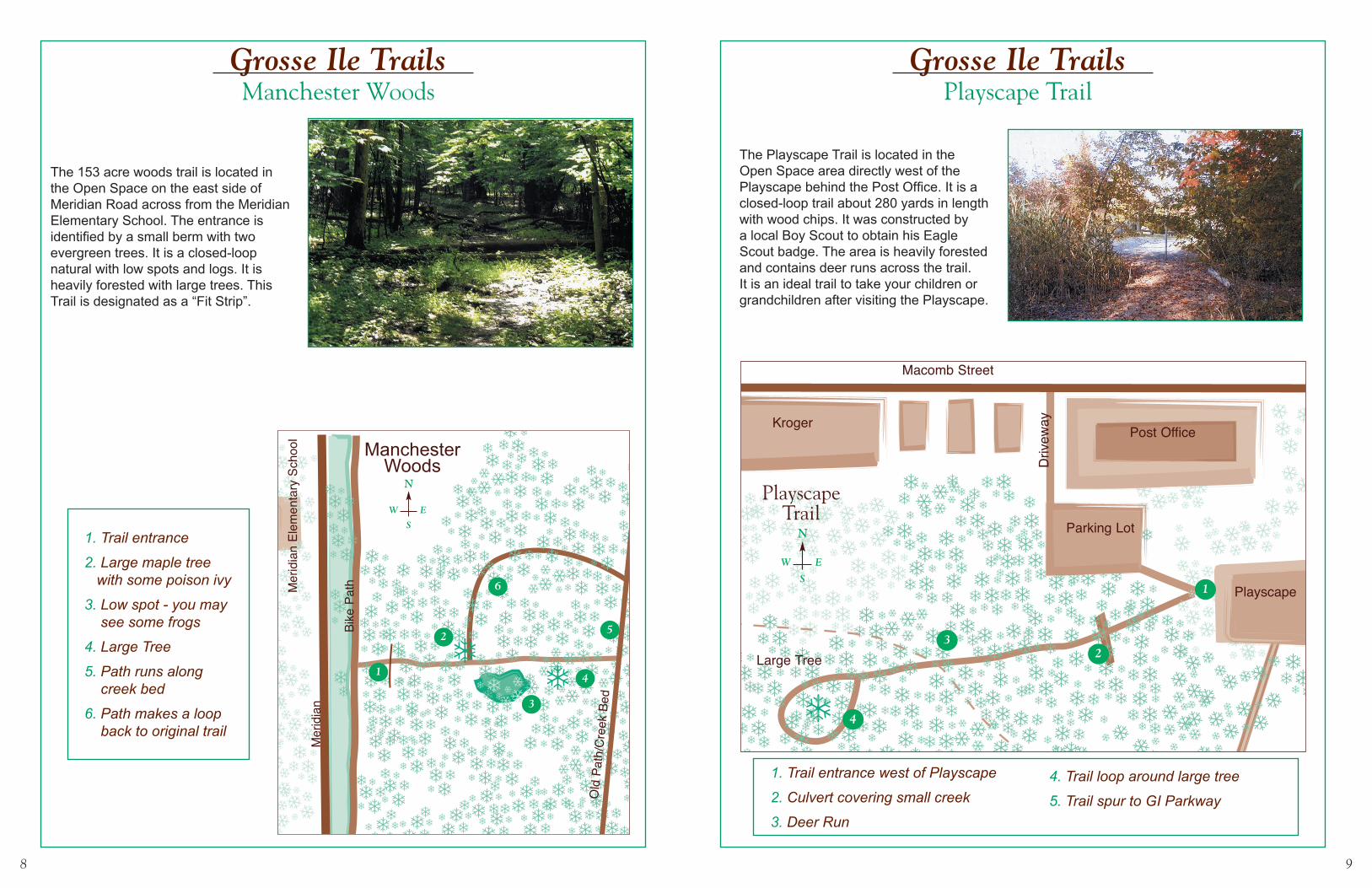
1. Trail entrance
2. Large maple treewith some poson ivy
3. Low spot - you maysee some frogs
4. Large tree
5. Path runs along creek bed
6. Path Makes a loop back to original trail
3
4
2
1
Mer
idia
n
Bike
Pat
h
Old
Pat
h/C
reek
Bed
Mer
idia
n El
emen
tary
Sch
ool
ManchesterWoods
N
S
EW
5
�
�
6
Grosse Ile TrailsManchester Woods
Grosse Ile TrailsPlayscape Trail
The Playscape Trail is located in the Open Space area directly west of the Playscape behind the Post Office. It is a closed-loop trail about 280 yards in length with wood chips. It was constructed by a local Boy Scout to obtain his Eagle Scout badge. The area is heavily forested and contains deer runs across the trail. It is an ideal trail to take your children or grandchildren after visiting the Playscape.
The 153 acre woods trail is located in the Open Space on the east side of Meridian Road across from the Meridian Elementary School. The entrance is identified by a small berm with two evergreen trees. It is a closed-loop natural with low spots and logs. It is heavily forested with large trees. This Trail is designated as a “Fit Strip”.
1. Trail entrance
2. Large maple treewith some poson ivy
3. Low spot - you maysee some frogs
4. Large tree
5. Path runs along creek bed
6. Path Makes a loop back to original trail
3
4
2
1
Mer
idia
n
Bike
Pat
h
Old
Pat
h/C
reek
Bed
Mer
idia
n El
emen
tary
Sch
ool
ManchesterWoods
N
S
EW
5
�
�
6
1. Trail entrance west of Playscape
2. Culvert covering small creek
3. Deer run
4. Trail loop around large tree
5. Trail spur to GI Parkway
3
4
2
1
Large Tree
Playscape
Macomb Street
Parking Lot
Driv
eway
Post OfficeKroger
PlayscapeTrail
N
S
EW
�
�
e
1. Trail entrance west of Playscape
2. Culvert covering small creek
3. Deer run
4. Trail loop around large tree
5. Trail spur to GI Parkway
3
4
2
1
Large Tree
Playscape
Macomb Street
Parking Lot
Driv
eway
Post OfficeKroger
PlayscapeTrail
N
S
EW
�
�
e
1. Trail entrance
2. Large maple tree with some poison ivy
3. Low spot - you may see some frogs
4. Large Tree
5. Path runs along creek bed
6. Path makes a loop back to original trail
1. Trail entrance west of Playscape
2. Culvert covering small creek
3. Deer Run
4. Trail loop around large tree
5. Trail spur to GI Parkway
10 11
Grosse Ile TrailsCentennial Farm Trail
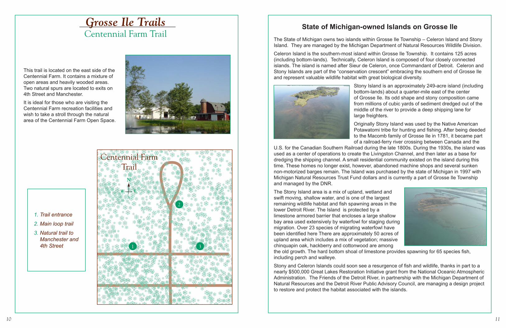
This trail is located on the east side of the Centennial Farm. It contains a mixture of open areas and heavily wooded areas. Two natural spurs are located to exits on 4th Street and Manchester.
It is ideal for those who are visiting the Centennial Farm recreation facilities and wish to take a stroll through the natural area of the Centennial Farm Open Space.
1
2
3
1. Trail entrance
2. Main loop trail
3. Natural trail to Manchester and 4th Street
State of Michigan-owned Islands on Grosse IleThe State of Michigan owns two islands within Grosse Ile Township – Celeron Island and Stony Island. They are managed by the Michigan Department of Natural Resources Wildlife Division.
Celeron Island is the southern-most island within Grosse Ile Township. It contains 125 acres (including bottom-lands). Technically, Celeron Island is composed of four closely connected islands. The island is named after Sieur de Celeron, once Commandant of Detroit. Celeron and Stony Islands are part of the “conservation crescent” embracing the southern end of Grosse Ile and represent valuable wildlife habitat with great biological diversity.
Stony Island is an approximately 249-acre island (including bottom-lands) about a quarter-mile east of the center of Grosse Ile. Its odd shape and stony composition came from millions of cubic yards of sediment dredged out of the middle of the river to provide a deep shipping lane for large freighters.
Originally Stony Island was used by the Native American Potawatomi tribe for hunting and fishing. After being deeded to the Macomb family of Grosse Ile in 1781, it became part of a railroad-ferry river crossing between Canada and the
U.S. for the Canadian Southern Railroad during the late 1800s. During the 1930s, the island was used as a center of operations to create the Livingston Channel, and then later as a base for dredging the shipping channel. A small residential community existed on the island during this time. These homes no longer exist, however, abandoned machine shops and several sunken non-motorized barges remain. The Island was purchased by the state of Michigan in 1997 with Michigan Natural Resources Trust Fund dollars and is currently a part of Grosse Ile Township and managed by the DNR.
The Stony Island area is a mix of upland, wetland and swift moving, shallow water, and is one of the largest remaining wildlife habitat and fish spawning areas in the lower Detroit River. The Island is protected by a limestone armored barrier that encloses a large shallow bay area used extensively by waterfowl for staging during migration. Over 23 species of migrating waterfowl have been identified here There are approximately 50 acres of upland area which includes a mix of vegetation; massive chinquapin oak, hackberry and cottonwood are among the old growth. The hard bottom shoal of limestone provides spawning for 65 species fish, including perch and walleye.
Stony and Celeron Islands could soon see a resurgence of fish and wildlife, thanks in part to a nearly $500,000 Great Lakes Restoration Initiative grant from the National Oceanic Atmospheric Administration. The Friends of the Detroit River, in partnership with the Michigan Department of Natural Resources and the Detroit River Public Advisory Council, are managing a design project to restore and protect the habitat associated with the islands.
1. Trail entrance
2. Large maple treewith some poson ivy
3. Low spot - you maysee some frogs
4. Large tree
5. Path runs along creek bed
6. Path Makes a loop back to original trail
3
4
2
1
Mer
idia
n
Bike
Pat
h
Old
Pat
h/C
reek
Bed
Mer
idia
n El
emen
tary
Sch
ool
ManchesterWoods
N
S
EW
5
�
�
6
Centennial FarmTrail
12 13
The Detroit River International Wildlife Refuge on Grosse IleIn 2001, the Detroit River International Wildlife Refuge was established as a result of binational efforts from politicians, conservation leaders, and local communities to build a sustainable future for the Detroit River and western Lake Erie ecosystems. Because of this collaboration, international status was given to the refuge, making it the first of its kind in North America. The refuge consists of nearly 6,000 acres of unique habitat, including islands, coastal wetlands, marshes, shoals, and waterfront lands within an authorized boundary extending along 48 miles of shoreline. Grosse Ile is located within the authorized boundary and includes three Refuge units, the Gibraltar Bay Unit, Sugar Island and Calf Island.
Gibraltar Bay Unit The Gibraltar Bay Unit is accessed from E. River Road and is adjacent to the Grosse Ile Township Airport. Much of the land of the Gibraltar Bay Unit was once used as a former D-51 Nike Missile site. The site was home to 30 anti-aircraft Nike Ajax missiles, 12 launchers, and two radar towers between 1955 and 1963. The embankment to Gibraltar Bay continues to protect the former launcher area. After the site clean-up was complete in 1998, the unit was planted to grassland habitat. The U.S. Department of Defense turned the site over to the U.S. Environmental Protection Agency (EPA) which partnered with the GINLC to restore the habitat and provide public access. A shoreline habitat project was completed in the mid-2000s introducing a number of native plants. Water flows through the embayment from the east side of Grosse Ile, and its aquatic plant community is diverse. Emergent species are threesquare, arrowhead, pickerelweed, flowering rush, and American lotus and emergent species include pondweeds, wild celery, muskgrass, and others. This bay is important for bass, pike, and long-nose gar.
With the establishment of the Detroit River International Wildlife Refuge, the U.S. Fish & Wildlife Service (FWS) took possession of the site from the EPA. The GINLC continues to have a presence at the Gibraltar Bay Unit, partnering with FWS, volunteering on habitat restoration projects and conducting Sunday Open House events and nature programs on a semi-regular basis May through October. Visit the GINLC website for more information, ginlc.org.
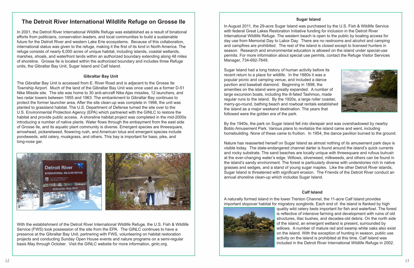
Sugar IslandIn August 2011, the 29-acre Sugar Island was purchased by the U.S. Fish & Wildlife Service with federal Great Lakes Restoration Initia tive funding for inclusion in the Detroit River International Wildlife Refuge. The western beach is open to the public by boating access for day use from Memorial Day to Labor Day. There are no restrooms and alcohol and camping and campfires are prohibited. The rest of the island is closed except to licensed hunters in season. Research and environmental education is allowed on the island under special-use permits. For more information about special use permits, contact the Refuge Visitor Services Manager, 734-692-7649.
Sugar Island had a long history of human activity before its recent return to a place for wildlife. In the 1880s it was a popular picnic and camping venue, and included a dance pavilion and baseball diamond. Beginning in 1898, the amenities on the island were greatly expanded. A number of large excursion boats, including the ill-fated Tashmoo, made regular runs to the island. By the 1920s, a large roller coaster, merry-go-round, bathing beach and rowboat rentals established the island as a major weekend destination. The years that followed were the golden era of the park.
By the 1940s, the park on Sugar Island fell into disrepair and was overshadowed by nearby Boblo Amusement Park. Various plans to revitalize the island came and went, including homebuilding. None of these came to fruition. In 1954, the dance pavilion burned to the ground.
Nature has reasserted herself on Sugar Island as almost nothing of its amusement park days is visible today. The state-endangered channel darter is found around the island’s quick currents and rocky substrate. The sand beaches are locally unique with threesquare and rufous bulrush at the ever-changing water’s edge. Willows, silverweed, milkweeds, and others can be found in the island’s sandy environment. The forest is particularly diverse with understories rich in native grasses and sedges, and a stand of young sugar maples. Like the other Detroit River islands, Sugar Island is threatened with significant erosion. The Friends of the Detroit River conduct an annual shoreline clean-up which includes Sugar Island.
Calf IslandA naturally formed island in the lower Trenton Channel, the 11-acre Calf Island provides important stopover habitat for migratory songbirds. Each end of the island is flanked by high
quality wild celery beds important for fish and waterfowl. The forest is reflective of intensive farming and development with ruins of old structures, lilac bushes, and decades-old debris. On the north side of the island, an emergent wetland is present, surrounded by willows. A number of mature red and swamp white oaks also exist on the island. With the exception of hunting in season, public use activity on the island is prohibited at this time. Calf Island was included in the Detroit River International Wildlife Refuge in 2002.

14 15
Grosse Ile Open Space Program and Grosse Ile Nature and Land Conservancy
The fact that Grosse Ile abounds with nature is no accident; it is the result of foresight, planning, commitment and effort on the part of Grosse Ile residents, elected officials, local, state and federal agency professionals and community volunteers. There are two organizations on Grosse Ile that are dedicated to preserving the natural character of our island community – the Grosse Ile Open Space / Greenways Program, reporting to the elected Township board and funded via millages assessed to the property owners, and the Grosse Ile Nature and Land Conservancy, a private, non-profit organization. The members of these two organizations are volunteers and are not compensated for their services.
Although these are separate organizations, they share a common goal of maintaining the natural beauty of our Island Community. In order to ensure close and effective communication on issues of common interest, one member of the Open Space Committee who is also a member of the Conservancy acts as a liaison between the two groups. The following is a brief description of the two groups, outlining their history and operating policies.
Open Space ProgramIn the early 1990s many residents and Township Board members realized that continued uncontrolled development of Grosse Ile would jeopardize the natural character of the community and over-extend the capacity of its infrastructure. To correct this potential problem, in 1994 the Township Board established an Open Space Program to purchase vacant lots and deed restrict them to ensure they remained in their natural state. They also established a committee to oversee the lands, maintain them and provide analyses and information to the Township Board as required. Two millages were approved by the voters, one to purchase land to be protected, and one to maintain the lands. To date, 566 acres have been purchased and protected. At the present time, both millages have been allowed to expire with $529,000 remaining in the acquisition account and $350,000 remaining in the maintenance account. Presently there are approximately 110 acres of privately owned vacant land that are suitable for protection under the Open Space Program.
The Open Space Committee consists of 7 volunteers appointed by the Township Board for a period of 3 years, including a representative from GINLC and from the Recreation Committee. A current Township Trustee also serves as liaison to the Open Space Committee. Current Open Space Committee projects include improving the condition of 4 existing trails, public service projects such as Dump the Junk, wood cutting for use by individuals and providing recommendations to the Township Board regarding property procurement.
Grosse Ile Nature and Land ConservancyThe Conservancy is a private non-profit organization (501c3). Established in 1993, its mission is “to promote for public benefit the preservation, stewardship and understanding of the natural resources in the Township of Grosse Ile and surrounding area.” To date, 41 acres of land and 121 acres of marshlands have been acquired by the GINLC. Funding for procuring GINLC lands is solely from donations from private individuals, foundations and grants. The Conservancy does not use any Township funds. In addition, the GINLC stewards many acres owned by the Township and the U.S. Fish & Wildlife Service.
The GINLC is led by a 21-member board elected by members at its annual meeting in November. Monthly board meetings are generally held at the Township Hall. Membership is open to all GI residents and off-island supporters.
One of the most notable areas is the natural area on the east side of the Airport property adjoining the Gibraltar Bay Unit of the Detroit River International Wildlife Refuge at the south end of E. River Road. Currently, this area and the GBU are open to the public on Sunday afternoons from May through October, stewarded by GINLC volunteers.
The Conservancy offers a variety of environmental educational programs throughout the year on Grosse Ile. More information is available at the GINLC website, www.ginlc.org and via the newsletter.
Contact Information & Rules of Conduct for Grosse Ile Nature Areas
Grosse Ile Open Space – GI Police 734-676-7100 to report violations of use.Open Space lands are accessible to the public during daylight hours for walking, nature photography, bird-watching and similar activities. Plants and animals are not to be disturbed or removed, except for invasive species such as garlic mustard during volunteer work sessions. Visitors must respect the privacy of adjacent residents and the rules of use.
Grosse Ile Nature and Land Conservancy lands – GI Police 734-676-7100 to report violations of use, GINLC email [email protected] lands are accessible to the public during daylight hours for passive recreational use (walking, nature observation and photography, etc). Plants and animals are not to be disturbed or removed, except for invasive species such as garlic mustard during volunteer work sessions. Visitors must respect the privacy of adjacent residents and the rules of use.
Michigan Department of Natural Resources – GI Police 734-676-7100 to report violations of use, and DNR RAP Line 1-800-292-7800. For Island questions contact the Pointe Mouillee State Game Area Headquarters at 734-379-9692.Stony and Celeron Islands are part of the Pointe Mouillee State Game Area and are managed by the Wildlife Division out of the Pointe Mouillee Headquarters. All Pointe Mouillee Game Area rules apply to the Islands and are enforced by DNR Law Division Conservation Officers. The Islands are open to hunting and trapping. There is no camping, no ground fires, no alcohol, and no use or occupancy from 11:00pm – 4:00am. See the game area map for further rules and regulations. Maps are available online at www.michigan.gov/dnr
Detroit River International Wildlife Refuge lands – GI Police 734-676-7100 to report violations of use, US Fish & Wildlife Service law enforcement officer 419-898-0014 ext 32, US Fish & Wildlife Service Visitor Services Manager 734-692-7649 As of this printing, DRIWR units are accessible as follows: the Gibraltar Bay Unit is accessible during Open House hours and special programs; Sugar Island west beach is accessible during daylight hours from Memorial Day to Labor Day; Sugar and Calf Islands are accessible during hunting seasons for licensed hunters. For up to date information on all refuge units, hunting regulations, and public use opportunities, please visit the Refuge web site at www.fws.gov/refuge/detroit_river/
Visiting Grosse Ile’s Natural Areas – Four Seasons of WonderDuring a visit to one of Grosse Ile’s natural areas, or even by stepping outside one’s front door, a Grosse Ile resident is sure to encounter a natural specimen of interest and beauty, from animals and plants to rocks deposited by Ice Age glaciers.
DucksMallardWood DuckCanvasbackMerganserScaupTealBuffleheadGolden-eye
MammalsBat (Little or Big Brown)Cotton tail RabbitCoyoteEastern Fox SquirrelField MouseFoxMinkMuskratOpossumRaccoonSkunkVole White-tailed Deer
InsectsAntBees, honeyBees, nativeButterfly, MonarchButterfly, SwallowtailDamselflyDragonflyFireflyHouse flyLadybugMosquitoPaper waspStaghorn beetleYellow jacket
Birds Am. RobinBald EagleBaltimore OrioleBlack-capped ChickadeeBlue JayCarolina WrenCommon TernEuropean StarlingFinch, GoldFinch, HouseFinch, PurpleGoose, CanadaGr. Blue HeronGr. EgretGull, HerringGull, Ring-billedHawk, Red-tailedHawk, Sharp-shinnedHummingbirdKingfisherN. CardinalOspreyOwl, E. Screech Owl, Gr. HornedRedpollRed-winged blackbirdSparrow, SongSparrow, White-throatedSparrow,HouseSwan, MuteSwan, TrumpeterSwan, TundraTufted TitmouseWoodpecker, DownyWoodpecker, HairyWoodpecker, Red-bellied
PlantsAsterBee BalmBlack-eyed SusanBluestem, BigBluestem, LittleButterfly WeedCardinal FlowerCattailConeflowerDogwoodFlowering RushIndian GrassJoe Pye WeedLilacMilkweedPhragmitesPoison IvyRufous BulrushService BerryThreesquareVirginia CreeperWild CeleryWild Grape
Reptiles & AmphibiansFrog, Am. BullFrog, Gray TreeFrog, GreenFrog, LeopardFrog, Spring PeeperMudpuppySalamanderSnake, E. FoxSnake, GarterSnake, N. WaterToad, AmericanTurtle, BoxTurtle, PaintedTurtle, Red-eared sliderTurtle, Soft-shell
FishBass, Large MouthBass, SilverBass, Small MouthBlue gillCatfishChannel DarterLake SturgeonPerchWalleyeWhite fish
TreesAm. BasswoodAm. ElmCottonwoodE. RedbudHickory, PignutHickory, ShagbarkHoney LocustHorse ChestnutMaple, SilverMaples, SugarOak, ChinquapinOak, RedOak, Swamp WhitePine, WhiteWalnut, Black
Printed on Recycled Paper