Embed Size (px)
DESCRIPTION
A selection from Change Over Time's second issue, the first of a two-part exploration of heritage recording and information management in the digital age.
Citation preview
ChangeOver Time
A n I n t e r n A t I o n A l J o u r n A l
o f c o n s e r v A t I o n A n d
t h e b u I l t e n v I r o n m e n t
F a l l 2 0 1 1
uPcomInG Issues
Digital Heritage, Part 2S p r i n g 2 0 1 2
AdaptationF a l l 2 0 1 2
NostalgiaS p r i n g 2 0 1 3
Interpretation and DisplayF a l l 2 0 1 3
The Venice Charter at 50S p r i n g 2 0 1 4
VandalismF a l l 2 0 1 4
Climate Change and LandscapeS p r i n g 2 0 1 5
IntegrityF a l l 2 0 1 5
National Park Service CentenaryS p r i n g 2 0 1 6
Change O
ver Time
F
al
l
20
11
1.2
Copyright © 2011 University of Pennsylvania Press.
All rights reserved.
Published by the University of Pennsylvania Press,
3905 Spruce Street, Philadelphia, PA 19104.
Printed in the U.S.A. on acid-free paper.
Change Over Time is seeking papers for two future themed
issues, Nostalgia (Spring 2013) and Interpretation and Display
(Fall 2013). Please visit cot.pennpress.org for a more detailed
discussion of these topics and deadlines for submission. Articles
are generally restricted to 7,500 words or fewer. Guidelines for
authors may be requested from Meredith Keller (cot@design
.upenn.edu).
None of the contents of this journal may be reproduced without
prior written consent of the University of Pennsylvania Press.
Authorization to photocopy is granted by the University of
Pennsylvania Press for individuals and for libraries or other users
registered with the Copyright Clearance Center (CCC) Transaction
Reporting Service, provided that all required fees are verified
with the CCC and payments are remitted directly to the CCC,
222 Rosewood Drive, Danvers, MA 01923. This consent does
not extend to other kinds of copying for general distribution, for
advertising or promotional purposes, for creating new collective
works, for database retrieval, or for resale.
2012 Subscription Information (USD)
Print and electronic:
Individuals: $35.00; Students: $20.00; Institutions: $70.00.
Single Issues: $10.00.
International orders, please add $17.00 for shipping.
Electronic-only:
Individuals: $31.50; Institutions: $63.00.
Subscriptions are valid January 1 through December 31.
Subscriptions received after October 31 in any year become
effective the following January 1. Subscribers joining mid-year
will receive immediately copies of all issues of Change Over Time
already in print for that year.
Please direct all subscription orders, inquiries, requests for single
issues, and address changes to: The Sheridan Press, Attn: Penn
Press Journals, P.O. Box 465, Hanover, PA 17331. Telephone:
717.632.3535, ask for subscriber services. Fax. 717.633.8920.
Email: [email protected]. Prepayment is required. Orders
may be charged to MasterCard, Visa, American Express, and
Discover credit cards. Checks and money orders should be made
payable to ‘‘University of Pennsylvania Press,’’ and sent to the
address immediately above. Postmaster: Send address changes
to The Sheridan Press, Attn: Penn Press Journals, P.O. Box 465,
Hanover, PA 17331.
Direct all other business correspondence to: Journals Division,
University of Pennsylvania Press, 3905 Spruce Street,
Philadelphia, PA 19104. Telephone: 215.898.6261. Fax:
215.766.3636. Email: [email protected].
Typographic cover artwork by Kerry Polite.
Visit Change Over Time on the web at cot.pennpress.org.
EDITOR IN CHIEF
Frank MateroUniversity of Pennsylvania
GUEST EDITOR
Mario Santana Quintero Raymond Lemaire International
Centre for Conservation, University of Leuven
ASSOCIATE EDITORS
Kecia L. Fong
Rosa Lowinger Rosa Lowinger & Associates,
Conservation of Art + Architecture, Inc.
EDITORIAL ASSISTANT
Meredith KellerUniversity of Pennsylvania
EDITORIAL ADVISORy BOARD
Nur AkinIstanbul Kultur University, Turkey
Erica AvramiWorld Monuments Fund
Luigia BindaPolitecnico di Milano, Italy
Daniel BluestoneUniversity of Virginia
Christine BoyerPrinceton University School of
Architecture
John Dixon HuntUniversity of Pennsylvania
Jukka JokilehtoUniversity of Nova Gorica
David LowenthalUniversity College London
Randall Mason University of Pennsylvania
Robert MelnickUniversity of Oregon
Elizabeth MilroyWesleyan University
Steven SemesUniversity of Notre Dame
Jeanne Marie TeutonicoGetty Conservation Institute
Ron Van OersUNESCO
Fernando VegasUniversidad Politécnica de Valencia
F A L L 2 0 1 1
V O L U M E 1
N U M B E R 2
I S S N 2 1 5 3 - 0 5 3 X
Change Over Time
Change Over TimeRunning an ad or special announcement in Change Over Time is a great way to get publication, program, and meeting information out to those in your field. Change Over Time is a semiannual journal focused on publishing original, peer-reviewed research papers and review articles on the history, theory, and praxis of conservation and the built envi-ronment. Each issue is dedicated to a particular theme as a method to promote critical discourse on contemporary conservation issues from multiple perspectives both within the field and across disciplines. Forthcoming issues will address topics such as Adaptation, Nostalgia, Interpretation and Display, and The Venice Charter at 50.
2012 Advertising Rates
Ads are inserted at the back of each issue and on cover 3 (inside back cover). Only cover 3 positioning is guaranteed.
Half Page: $200 Full Page: $300 Cover 3: $350
Issue Closing Dates
Mechanical Specifications
Half Page: 5¼” x 4” Full Page: 5¼” x 8¼” Cover 3: 6” x 8½”
All journals are black and white and printed offset on matte stock. Ads must be emailed as print-optimized PDF files.Images should be scanned at a resolution of 300 dpi.All fonts should be embedded (type I fonts recommended).Halftones are shot at 133-line screen. No bleeds.
Submission Address and Contact Info
Send reservations and materials, formatted according to specs, to:
Dave Lievens, Editing & Production CoordinatorUniversity of Pennsylvania Press3905 Spruce Street, Philadelphia, PA 19104-4112Email: [email protected]; Fax: 215-746-3636
A complete ad rate card may be downloaded at cot.pennpress.org by selecting the “Advertising” link from the left menu bar.
Artwork Deadline
3/30/12
9/28/12
ReservationDeadline
3/16/12
9/14/12
Publication Date
5/30/12
11/30/12
Season & Theme
Spring 2012Digital Heritage,
Part 2
Fall 2012Adaptation
ChangeOverTime
A N I N T E R N A T I O N A L J O U R N A L
O F C O N S E R V A T I O N
A N D T H E B U I L T E N V I R O N M E N T
F A L L 2 0 1 1 1.2

CONTENTS
152 EditorialF R A N K M AT E R O
156 Heritage Recording and InformationManagement in the Digital Age(SMARTdoc-heritage)M A R I O S A N TA N A Q U I N T E R O A N D O N A
V I L E I K I S
E S S A Y S
166 Dedication: Robin Letellier (1944–2007)F R A N C O I S L E B L A N C
168 Metric Condition Records: Does the CaptureMethod or the Information Need Determinethe Performance of 3D Heritage Records?B I L L B L A K E
184 HABS Documentation in the Digital Age:Combining Traditional and New 3D Methodsof RecordingC A T H E R I N E C . L AV O I E
198 Advanced 3D Recording Techniques for theDigital Conservation and Presentation ofHeritage Sites and ObjectsFA B I O R E M O N D I N O
168
198
216
236
268
216 Photography in Heritage Research: In Searchof Digital Standards for Image Capture,Image Processing, and Image DeliveryJ O S E P H E . B . E L L I O T T
236 Multispectral Sensors in Combination withRecording Tools for Cultural HeritageDocumentationJ O S E L U I S L E R M A , T A L A L A K A S H E H , N A I F
H A D D A D , A N D M I R I A M C A B R E L L E S
252 Laser Scanning the Past for the Future:Baalbek TempleB J O R N VA N G E N E C H T E N , M A R I O S A N TA N A
Q U I N T E R O , A S S A A D S E I F, A N D G H A S S A N
G H AT TA S
268 Terrestrial Laser Scanning: Imaging,Quantifying, and Monitoring MicroscaleSurface Deterioration of Stone at HeritageSitesJ E S S I C A K O T T K E , J O H N H I N C H M A N , A N D
F R A N K M AT E R O


ChangeOverTime

1 5 2
EDITORIAL
F R A N K M A T E R O
U N I V E R S I T Y O F P E N N S Y L V A N I A
Figure 1. ‘‘The Ar t of Restoring,’’ Fun Vol 25, June 27, 1877. The satirical warnings of irreversible restorationfictions by nineteenth-century critics led to the importance of documentation and recording as the foundationfor all conservation actions. Improved methods of data capture and manipulation have resulted in an informationrevolution for heritage professionals; however, the challenge remains as how to best apply and use the newtechnology for informed conservation decisions. (University of Florida George A. Smathers Libraries; http://ufdc.ufl.edu/UF00078627/00030/)

What is past is prologue.
William Shakespeare, The Tempest
Many built works pass down through time. How they are received by each generation is
ultimately a function of what we know and feel about them and what ultimately becomes
heritage. Conservation/preservation therefore has always been about transmission and
reception. As the second-century grammarian Terentianus Maurus pronounced, Habent
sua fata libelli—books always have their histories—and so it is with the physical places we
inhabit. What survives, what is forgotten, and what is cared for or destroyed describe the
lives buildings and places acquire over time. Such trajectories are dependent on many
diverse factors; however, once consciously examined, all built heritage comes under consid-
eration for its ability to communicate to us; to have relevance in ways consistent or new
to its original authorship.
As stated by the Italian theorist Cesare Brandi, ‘‘restoration [conservation] is the
methodological moment in which the work . . . is appreciated in its material form and in
its historical and aesthetic duality, with a view to transmitting it to the future.’’1 It is a
true historical event, a human action that is part of the process by which a work is trans-
mitted and received. The act of preservation is therefore the actual moment of the con-
scious contemplation of cultural heritage primarily for its historical value; it is, in a sense,
the ‘‘afterlife’’ of any created work.
Recording is one way in which those concerned with built heritage attempt to capture
physical aspects deemed significant or defining of a thing or place. For the architect this
may be the plan, section, and elevations of a building; for the architectural historian it
may be a comparative stylistic analysis of the classical orders; for the engineer it may be
the gradual movement of a wall or dome over several years; and for the conservator it may
involve recording a multitude of decay phenomena. Regardless of intent, recording and its
acquisition-hungry sister, documentation, are the cornerstones of conservation practice.
Heritage specialists perform documentation and recording based on the belief that by
accumulating and producing records of the tangible aspects of the built environment, one
can preserve inherent informational and aesthetic values, or at least the potential values,
that may be lost through natural degradation and human modification.
M A T E R O E D I T O R I A L 1 5 3

1 5 4 C H A N G E O V E R T I M E
Traditionally, documentation and recording for conservation have long been associ-
ated with the physical state or condition of an object or site in danger of being lost or
damaged and immediately before and after intervention. No doubt this can be attributed
to the physical changes most conservation treatments affect, as well as the contributions
that documentation can make toward an increased understanding of the past appear-
ance or technology of the object or site. But it has been through the study of existing
condition as a record of past change that heritage specialists have seen the value of
documentation and recording in developing a more accurate knowledge of alteration
and deterioration, especially long-term trends and patterns of anthropogenic change
and natural weathering. By studying current condition as the cumulative result of
change over time through careful observation and description, one can come closer to
managing change as responsible stewardship.
The documentation of structures and sites and associated building arts such as sculp-
ture, mosaics, and wall painting presents enormous difficulties, attributable as much to
their size and complexity as to the pressures of utility and context. A great many agents
and phenomena, ancient and modern, transform sites over time and in different ways. A
variety of natural and cultural processes including natural decay and human actions con-
tinually alter a building’s fabric and form. Daily maintenance, intermittent repair, use and
reuse, neglect, decay, abandonment, and recovery are among the diverse yet plausible
processes that translate past actions and events into present conditions. As a result, the
physical status of any structure or site is a record of the interaction of many different
determinants over the course of its life. For many structures and sites these include (in
general order of occurrence):
• original design, materials, and construction techniques
• subsequent changes through use, human alteration, and natural aging
• micro- and macro-environments and climate
• disuse and/or abandonment
• destruction and/or burial
• rediscovery (excavation in the case of archaeological sites)
• conservation, reuse, display, and maintenance
These determinants characterize individual episodes in the shaping of the built envi-
ronment and as such define the ‘‘life cycle’’ for materials, structures, and sites. Such mod-
els, commonly used by archaeologists to explain multivariate change over time have been
adopted by relatively few heritage specialists to study and explain the transformation of
cultural resources.2 By considering performance, function, deterioration, and intervention
in a more holistic and integrated manner—linking design, environment, and human
agency—heritage specialists can develop and apply documentation and recording methods
focused on cultural as well as etiological concerns.
The road to effective stewardship must therefore begin with a conscious understand-
ing of why and when we record. Within recent years, the technology of producing and

managing more accurate and comprehensive documentation has increased dramatically
through the development of newer imaging and computer graphic software including geo-
graphic information systems, 3D laser imaging, and the application of nondestructive
investigation. These tools provide the key to better management decisions by allowing
greater data integration and dissemination and more frequent monitoring and risk assess-
ment, which goes far beyond earlier interests in simply recording a structure or place
for posterity or recording the immediate physical status before and after intervention.
Nevertheless, all recording, no matter how sophisticated, is deceptively subjective, always
performed with a specific objective or from a particular point of view. Contrary to modern
scientistic notions, it is the moment at which interpretation begins.
The papers presented in this special issue of Change Over Time represent a diverse
array of interests, approaches, and practices by an equally diverse group of heritage profes-
sionals. It is our hope that in convening such an international gathering of experts on the
subjects of digital heritage recording, documentation, and information management, and
publishing a selection of the papers presented in this and the forthcoming issue of the
journal, we have opened up the conversation to address not just what and how, but why
and when we record built heritage.
References1. Cesare Brandi, ‘‘Theory of Restoration, I,’’ in Historical and Philosophical Issues in the Conservation of
Cultural Heritage, eds. Nicholas Stanley Price, Mansfield Kirby Talley, and Alessandra Melucco Vaccaro(Canada: Getty Conservation Institute, 1996), 231.
2. Examples include: Daniel Bluestone, Buildings, Landscapes and Memory: Case Studies in Historic Preserva-tion (New York: Norton, 2011); M. Christine Boyer, The City of Collective Memory (Cambridge andLondon: MIT Press, 1996); Stewart Brand, How Buildings Learn (New York: Penguin Books, 1994); andNeil Harris, Building Lives (New Haven and London: Yale University Press, 1999).
M A T E R O E D I T O R I A L 1 5 5
1 6 8
METRIC CONDITION RECORDS
Does the Capture Method or the Information Need Determine the Performance
of 3D Heritage Records?
B I L L B L A K E
B I L L B L A K E H E R I T A G E D O C U M E N T A T I O N
Figure 1. Undifferentiated and differentiated data. Top: detail from a 1:200 scale or thophotograph of ChatterleyWhitfield Colliery, Staffordshire, England, showing undifferentiated data. Bottom: the same segment of the siteas recorded by measured survey at a 1:50 scale; this is highly differentiated and has been captured for thedetailed planning of the building conservation program. (English Heritage)

The interdependency of our questions about the historic environment and the data capture techniques used toanswer them is complex. Metric survey is a primary tool that, directed correctly through brief and specification,can provide useful data for the heritage information process. The inherent differences in data quality derivedfrom different techniques are primarily a result of capture by two classes of information: undifferentiated (derivedfrom indirect techniques such as photogrammetry and laser scanning) and differentiated (derived from directtechniques such as measured drawing, total station, and global positioning systems [GPSs]). The value andutility of information is thus dependent on the method chosen for its capture; it may demonstrate selectivity tomeet a particular purpose or be an unselective record for future interpretation. An appropriate response toinformation requirements should be shaped by an understanding of the significance and value of the heritage(as described under Article 16 of the ICOMOS Charter of Venice, May 31, 1964) to be recorded along with theperformance of capture techniques.
What Is Heritage Documentation?
Documentation is both a process and a product. Heritage documentation is most
effective when it is a continuous process. In this way it best serves conservation by supply-
ing the data necessary for understanding the condition of a site or object and is fundamen-
tal for all monitoring and maintenance. Documentation is necessary throughout the
conservation process from recording, assessment, and treatment to periodic evaluation.
Through the actions of recording, documentation makes tangible and intangible (e.g.,
song, dance, and ritual performances) heritage available to specialists and the public in a
broad array of forms such as metric, narrative, thematic, and societal records. Metric
survey is a key aspect of heritage documentation as recognized by ICOMOS in Principles
for the Recording of Monuments, Groups of Buildings and Sites (1996) ratified by the 11th
ICOMOS General Assembly in Sofia, October 1996:
Recording is the capture of information which describes the physical configuration,
condition and use of monuments, groups of buildings and sites, at points in time
and it is an essential part of the conservation process.
Technologies in Conflict
In commissioning heritage records there is a balance to be struck between conservation
needs, the level of detail and accuracy required of the documentation, and the significance
of the heritage to be recorded. Consideration of these factors informs the selection of the
B L A K E M E T R I C C O N D I T I O N R E C O R D S 1 6 9

1 7 0 C H A N G E O V E R T I M E
recording technique. The balance between selective and objective records needs to be made
by a careful choice of technique informed by an appropriate response to significance and
information need. The selective nature of recording technologies is variable; for example,
a measured drawing has a completely different characteristic than a point cloud collected
by a laser scanner. Both sets of data are incomplete and both are dependent on the opera-
tor’s viewpoint. They differ immensely in terms of content: the drawing will be a delinea-
tion of the draftsman’s view, whereas the point cloud will have no such interpretive
information. In all documentation, the practitioner should be able to intelligently answer
the questions: ‘‘What and why am I recording, and why have I chosen that specific tech-
nique?’’
It may be that an attempt to draw a brick facade by tracing it is considered inappro-
priate on the grounds that it is uneconomical and imprecise, but the same facade recorded
with a laser scanner may not produce a more economical outcome. It is not reasonable to
assert that a laser scanner is the right tool for the job simply because such a device is
available or that the sheer volume of data will provide a ‘‘full digital record’’ or even that
the act of scanning equates to ‘‘digital heritage preservation’’!
The Three Key Processes in Documentation
The delivery of useful documentation for heritage projects requires negotiating three key
processes of measurement, selection, and communication.
1. Measurement or information capture technique is where the choice of technolo-
gies can determine the precision and nature of the data deliverable (for example,
drawing, photograph, point cloud, model).
2. Selection of significant information dictates how efficiently the capture method
will match the information need. The selection of information from a captured
data set can be active at capture or made post-capture by interpretation of an
undifferentiated data set. The choice of measurement technique will determine
both the degree of information recovery possible and its dependency on the
response to significance either during or post-capture.
3. Communication or presentation determines the utility of the captured informa-
tion set. A poor understanding of the convention or visual language of draftsman-
ship or cartography can devalue spatial information to the point where it can
nullify the value of the documentation process and product. The transmission of
information from capture (often by a surveyor) to end user (a conservator or
resource manager) requires abstraction by line point, shade, tone, symbol, and
model according to convention so that the information is readable, current, and
relevant. Getting the balance between capture method and presentation standard
is the heart and soul of recording, or in the words of Thomas and Leonard Digges,
two of the founders of modern survey practice:

so the Geometer, how excellent so ever he be, leaning onely to discourse of
reason, without practise (yea and that sundrie wayes made) shall fall into
manifolde errors or inextricable Laberinthes. Pantometria, 1571.
Heritage assets, by their very nature, are vulnerable to a wide variety of stresses, not
the least being the very effect of their significance and value. In broadcasting heritage
values, touristic and economic pressures on the heritage asset are inevitable. Preventative
maintenance inadequacies, material failures, instability, excessive use, visitor damage,
excessive loading, and inappropriate interventions are all likely once a structure or land-
scape has passed from its historic use to a ‘‘heritage’’ role. The documentation needed to
inform sound heritage management is dependent on our choices about the nature, utility,
and extent of that information in heritage management.
Such 3D capture systems as photogrammetry and laser scanning have a variety of
performances (e.g., angular measurement precision, distance measurement precision,
range precision, light reflectance sensitivity, point density, etc.), and matching the system
to the desired information outcome requires a good understanding of both the system and
the information-user requirements. Heritage documentation requires information types,
which are either differentiated or undifferentiated (Fig. 1). This distinction is important in
answering the primary performance question of the information user: should the selection
process be active (where the surveyor chooses which points or lines describe the subject)
or passive (where the selection of information is made from the data rather than the
subject) at capture? The next level of analysis is the ‘‘fit for purpose’’ requirement of the
information, which will be influenced by the end use of the captured information. To
ensure the information requirement is met, detailed briefs and specifications have been
found to be necessary to achieve outcomes that are predictable.
Data Differentiation: Direct and Indirect Capture Methods
It is possible to achieve continuous undifferentiated data capture by use of techniques
like photography (Figs. 2 and 3), photogrammetry, and laser scanning. The quality of the
information can be largely determined by the performance of the capture system. For
example, the performance of an orthophotograph is a function of the camera, the subject
area captured by each image (photo cover), control, and digital surface model (DSM) gener-
ation; all of these can be documented and examined as a part of the process metadata
(Fig. 1). Laser scan data has similar process-dependent metadata performance indicators
(e.g., area of coverage, control point density, and registration data). The notable difference
is that the data are rarely, with the exception of the ‘‘artifact’’ group of scanners, continuous.
Laser scanning supplies data that are principally influenced by the choice of scan position
and system performance rather than by information selection issues. Data capture by
systems like photogrammetry and laser scanning are said to be ‘‘indirect’’ as information
selection is not the principal influence on the capture process, whereas direct methods
rely on the selection of information at the point of capture. Indirect systems are character-
B L A K E M E T R I C C O N D I T I O N R E C O R D S 1 7 1

1 7 2 C H A N G E O V E R T I M E
Figure 2. Detail from a rectified photograph of a thir teenth-century cur tain wall at Tamworth Castle. Theimage records not only the metric disposition of the material but also surface condition in the form ofstaining, cracking, friable and hollowed elements, material type by color, and more. (Wessex Archaeology)
ized by the post-capture analysis phases, during which time information can be extracted
(e.g., in photogrammetry, the process of line plotting or producing surfaced models from
point clouds in laser scanning).
Active and Passive Information Selection
Information capture is governed by the primary reasons for undertaking documentation.
A passive approach assumes information can be recovered from the captured set at a
future date without stating any particular need other than a baseline level of capture. Such
approaches are common in ante-disaster records and rely on the robustness of the primary
data. In photogrammetry this is well-understood,1 and good examples of successful disas-
ter recovery (e.g., the postfire recovery of lost ceiling details at Windsor Castle in 1992 by

prefire photogrammetry) show this is effective.2 Active information selection requires an
agreement between the user and provider, in the form of a brief and specification, on the
function of the captured information and the required constraints on selection perform-
ance (e.g., agreement on how many points should be captured to describe a line to be
presented at a given scale).
Heritage Documentation Information Needs
The specific requirements of heritage documentation are characterized by a number of
information performances (e.g., scale of presentation, density of point capture, appro-
priate selection of lines to describe a plan).3 The principle of ‘‘fit for purpose’’ is often cited
as a description of both the scale of output and the level of abstraction required. It is
worth noting the requirement for 3D information is not usual in heritage documentation
and considerations of condition recording and monitoring in 2D are more common in
the acquisition of heritage management information. It is possible to describe heritage
information needs as a hierarchy with the inventory as the first level and conservation
action and site management as the last. It is recognized that the information requirement
is cyclic, and that the conservation cycle has both initial and continuing information
needs, at both the asset evaluation and monitoring stages.
Condition Monitoring Concepts in Heritage Asset Management
Monitoring refers to the measurement of change on the condition or nature of the asset.
The changes may be:
1. Micro (chemical composition of material, moisture migration, etc.)
2. Macro (structural movement, damage, color degradation, geotechnical, etc.)
3. Environmental (microclimate, local climatic, fire risk monitoring, etc.)
The monitoring of structural movement typically involves the measurement and anal-
ysis of dynamic strains, loads, vibrations and displacements, pressures, and temperatures.
The aim is to determine the risk of structural failure and priority in the structural inter-
vention.4
The identification of the points of likely failure (usually through fatigue, stress, or
environmental reaction) is essential and requires careful inspection based on experience
of the behavior of similar structures and materials. Structural monitoring includes the
investigation and mapping of soil and geological conditions pertinent to structural move-
ment as well as examination of the structure itself.
The monitoring of material performance is frequently conducted concurrently with
the monitoring of structural stability but uses point-sampling methods to determine the
action of moisture, oxidation, and salinity and the effect of atmospheric pollutants such
as sulphur dioxide on the material. All monitoring systems require four key concepts to
operate:
B L A K E M E T R I C C O N D I T I O N R E C O R D S 1 7 3

1 7 4 C H A N G E O V E R T I M E
Figure 3. Kite aerial photograph of the Archer Pavilion, Wrest Park, Bedfordshire, England. Raising thecamera to see surfaces hidden from the ground is easy compared to raising a scanner or total station forthe same effect. In this case the camera was raised by a kite. (Bill Blake Heritage Documentation, usedwith permission of English Heritage)
1. The identification of the theoretical model to be tested by measurement
2. A repeatable comparable baseline data set
3. A consistent system of cyclical recording
4. A program of periodic review of the data, the model, and the structure
Properties of Monitoring Systems for Heritage Asset Management
The assertion that laser scan data5 can be used to monitor structural movement needs to
be evaluated against structural movement–monitoring measurement system require-
ments, which include:
1. A known tolerance of each measurement cycle and the recording of the environ-
mental conditions at the time of capture
2. Confidence that the tolerance in the measurement system is sufficient to record
the anticipated change
3. Operation of cyclical measurement by personnel trained to include the calibration
and measurement of environmental statistics with each cycle
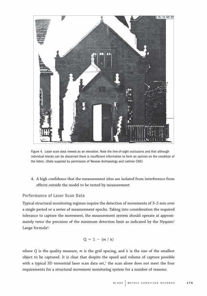
Figure 4. Laser scan data viewed as an elevation. Note the line-of-sight occlusions and that althoughindividual blocks can be discerned there is insufficient information to form an opinion on the condition ofthe fabric. (Data supplied by permission of Wessex Archaeology and Latimer CAD)
4. A high confidence that the measurement sites are isolated from interference from
effects outside the model to be tested by measurement
Performance of Laser Scan Data
Typical structural monitoring regimes require the detection of movements of 3–5 mm over
a single period or a series of measurement epochs. Taking into consideration the required
tolerance to capture the movement, the measurement system should operate at approxi-
mately twice the precision of the minimum detection limit as indicated by the Nyquist/
Lange formula6:
Q � 1 � (m / �)
where Q is the quality measure, m is the grid spacing, and � is the size of the smallest
object to be captured. It is clear that despite the speed and volume of capture possible
with a typical 3D terrestrial laser scan data set,7 the scan alone does not meet the four
requirements for a structural movement monitoring system for a number of reasons:
B L A K E M E T R I C C O N D I T I O N R E C O R D S 1 7 5

1 7 6 C H A N G E O V E R T I M E
Method Cycle Precision Typical application
Tell-tale Subject to Requires repeat Surface crack monitoring:inspection cycle hit and miss � 3–5 mm
Strain gauge Automatic submillimeter Load monitoring acrosse.g., Demec fixed points
Precise level Manual 0.3–0.9 mm Floor and ceiling deformatione.g., Leica DNA to premarked points03/09 with invarstaffx
Auto-plumb Manual 1 mm at 30 m Point to point verticale.g., Leica ZNLxx alignment
High frequency Automatic 0.5 mm Plant movement, dynamicfixed position IR loads
Close range Image recapture 5–10 mm Surface damage mapping;Photogrammetry profile extraction;
Automated self- Automatic 0.5 mm real-time deformationcalibrating monitoring of fixed points0.5� Total station net-workxx
Fixed plane laser range Automatic 1–2 mm to fixed Tunnel profilingscanning prisme.g., Amberg systemxx 2–3 mm
reflectorless
Terrestrial 3D Laser Manual Between 2–5 mm Mass capture of unassignedscanner and 5–15 mm point positions at 10 mm �e.g., Leica HDS/ 10 mm spacingTrimble GS 200xx
x Information supplied by Button, T, Dip Ld. Surv., SCCS Ltdxx Leica AG product description, 2003.
Table 1. Measurement methods for monitoring structural movement.
1. Point density and point selection. The location of monitoring points is key to the
monitoring process. Structural engineers select diagnostic points on the basis of
their indicative properties; the points are chosen as markers of components and
references against which movements can be detected. Point cloud data are charac-
terized by a high density of points that may or may not be coincident with the
diagnostic points required for structural movement monitoring.
2. Variable tolerance of range measurement performance. The precision of monitoring
measurement must be predictable. Terrestrial laser scanning devices have a wide
range of distance variation, and as such measurements cannot be considered in
the same way as the discrete point to point measurements used for movement
monitoring.
3. Scanner location-dependent data (Fig. 4). The point cloud and the implied precision
of its points are factors of not only the scanner performance. The incident angle
of the measurement beam to the surface measured is unique to each scan. A
change in the position of the scanner will generate changes in the incident angles
and thus present a different bias in the range data.8 If the scan data is to be used
for movement monitoring, scan positions and orientation need to be precisely
controlled.
The Problem of Interpolated Surface Data
Detecting small-area deflections across surfaces is extremely difficult. The surface informa-
tion derived from photogrammetry is dependent on imagery with sufficient textural infor-
mation to achieve good results. Laser scan data is ideal for surface generation but lacks
the data recoverability inherent in photogrammetry.
Unknown Performance of Repeatable Data Sets
The cycle of information capture for structural movement monitoring may extend over a
number of years. For this reason relatively simple devices (e.g., Demec gauge, tell-tale,
etc.) with predictable performance are widely used (Table 1). Laser scanners, despite their
highly efficient rates of capture, are subject to development, and designs have not been
standardized as yet. Variations in reflectance and environmental conditions at the time of
measurement can be ameliorated in simple systems (by dint of measuring unique points
repeatedly rather than many points indiscriminately), but the impact of these factors on
the performance of laser scan data is less well known. For example, a simple constraint
like the minimum range of predictable distance propagation may well limit the application
of certain types of laser scanners.
A comparison between the performance of current, principally 2D techniques and
laser scanning shows how the problem of displacement mapping is typically addressed by
instrumentation. The importance of discrete point measurement over a fixed period of
time (either by automation or manual methods) is fundamental to displacement monitor-
ing in structures.
Heritage Documentation in 3D: Properties of Heritage Assets and Their Records
It is important to recognize that the rich and unique qualities of heritage places that must
be captured in the information sets needed to manage them are complex and sometimes
subjective. The historical, societal, artistic, and associative values of a heritage place may
not be recordable as metric data alone but, nonetheless, the captured data will fail in its
utility if it does not respect these values at the presentation stage of the data cycle. The
expectations of heritage stakeholders will be that the values associated with a heritage
place will be present in some form in the quality of the captured record.
Heritage records need to satisfy set minimum functions (e.g., metric precision, ade-
B L A K E M E T R I C C O N D I T I O N R E C O R D S 1 7 7

1 7 8 C H A N G E O V E R T I M E
quate information selection, and accurate depiction) to be effective. It is normal for heri-
tage documentation to comprise a variety of information types both metrically and
nonmetrically.
Some aspects of heritage places can only be shared by means of visual media analysis
in 3D such as illustrations to show the spatial development of spaces and objects; for
example, rock art in caves or the recording of tunnel systems. In some cases the process
of fitting theory to the 3D data by modeling brings new insights to its understanding; in
others the ability to section and reveal hidden details is a benefit of 3D information.
For example, the modeling of the 1,800 components of the Ironbridge at Coalbrookedale,
Shropshire, from wire-frame data was supplied by photogrammetry, whereas laser scan
and TST data were used to test manufacture and assembly sequences against historical
records to decode the method of erection (Fig. 5, middle).
The illustration of Landguard Fort, Felixstowe, Suffolk, England (Fig. 5, left), showing
the internal disposition of the magazines, shell, cartridge hoists, and gun embrasures was
assembled from a CAD model from metric CAD plans and the selected wire-frame was
mapped by reflectorless EDM (REDM). The information was used to control the geometry
for a guidebook illustration. The transparent view shows both the large scale of the struc-
ture and the functional links of the internal layout, features that are difficult to experience
from a position outside or inside the fort.
The bell frame in the church tower at Attenborough, Norfolk, England (Fig. 5, right),
is an element to which few visitors will be granted access. Bell frames are usually a tight
fit into the tower and their forms are hard to comprehend, as a clear view is rarely possible.
A 3D model derived from REDM wire-frame and measured drawings shows more than
photography alone, and is used on site to explain the function of the tower.
The process of constructing the CAD model of the Ironbridge (Fig. 5, middle) enabled
testing of design and assembly theory. The metric base for the model was primarily photo-
grammetric with infill from a laser scan and REDM. Making use of a consistent metric
basis allowed the detection of variations in the manufacturing of the components for the
first time and enabled a new analysis of the production and assembly process of the span.

Figure 5. Landguard For t, Felixstowe, Suffolk, England(left); detail of the Ironbridge at Coalbrookdale,Shropshire, England (middle); the bell frame at St. Mary’sChurch, Attleborough, Norfolk, England (right). (EnglishHeritage)
Each of these models was prepared for a specific outcome, and the underpinning of
3D data sources met the common constraint of metric performance for a given scale of
record. The 3D modeling process has added to the investigative tools by means of ‘‘virtual
testing’’ of components for fit and pattern origin. This is a far cry from offering a ‘‘digital
surrogate’’ or virtual substitute for an object for analysis but, nonetheless, on the basis of
a relatively low density of information, has added to our understanding of these heritage
places by prompting questions as to the component manufacture methods, assembly
sequence, and repair history to the historical analysts from the modeler.
Managing Information for Heritage Documentation
To get the needed information to the right people at the right time requires information
capture to be integrated into the conservation process. The control of information quality
and its application is the starting point for heritage documentation standards. Managing
the capture of information from the historic environment requires two processes to be
effective:
1. Preparation and agreement of a brief between the information user and the infor-
mation supplier for the performance, scope, and content of the deliverables
2. Application of specifications including the definitions of the required products9
Heritage asset management requires integration of the specialist disciplines engaged
in the protection, conservation, and development of heritage places. In order for the high
cost of 3D records and their products to be validated, cross-disciplinary information needs
to be addressed at the conservation planning phase.
Understanding the Value of 3D Records
In itself, 3D information is not a goal in heritage documentation; it is a valuable property
of many metric data sets and, particularly in photogrammetry, a crucial method of infor-
B L A K E M E T R I C C O N D I T I O N R E C O R D S 1 7 9

1 8 0 C H A N G E O V E R T I M E
mation recovery in the event of loss or damage to heritage assets. The 3D-heritage infor-
mation is valuable for
1. Data recovery from indirect capture, particularly in ante-disaster records
2. Post-capture analysis where information is of sufficient density to support the
required selection needs
3. Proof of data origin; 3D data sets have the potential for automatic capture of
crucial metadata, which is invaluable for information recovery
4. Terrain interpretation
5. Clarity of communication of spatial, textural, and surface-biased information (i.e.,
declaration of surface treatment used in the model, indicator of model parity to
measurement set, etc.)
The availability of new data types (e.g., the laser-scanned point clouds) has yet to
establish a strong value in heritage documentation for structures, despite obvious suc-
cesses in landscape recording (airborne LIDAR) and for object records such as statuary.
The information needs for the management of heritage structures are specific, and for
example, the assertion that movement monitoring and condition mapping are possible
from laser scan data needs careful evaluation, particularly by those who are charged with
these tasks.10 The development of useful 3D products that support the documentation of
heritage assets continues, and the acceleration of our understanding and enjoyment of our
heritage that rich 3D records enable benefits us all.
Conclusion
In looking at the need for condition records, it is possible to describe the information
need as threefold:
a. Assessment of condition
b. Monitoring of condition
c. Ante-disaster
Each of these information classes requires different levels of data in terms of both inten-
sity and density; for example, initial assessment records need to reflect the extent, heritage
value, and areas of vulnerability but need not be at the same scale or point density as an
ante-disaster record. Variation in scale, information density, and type will occur according
to the project needs and the resources available to acquire them. Traditional 2D records,
while adequate in many cases, may well save time and money but may be of limited value
if detailed reconstruction or surface monitoring is needed.
The distinction between 2D and 3D technologies must be considered carefully as the
sustainability of methods is important when cyclic recording is envisaged. For example, a
robust 2D method like site photography with 3D TST control has strong advantages in
terms of skill accessibility, whereas a 3D method such as laser scanning may generate a

strong information gain but at a very high cost of specific training. The simplicity of a 2D
information set (such as photographs and drawings) may have greater local benefit than a3D data set dependent on highly skilled interpretation.
The output processes of 3D recording are developing, but to date do not presenteasily accessible information in the way traditional 2D methods do. An assessment anddefinition of the use of 3D modeling in the documentation of cultural heritage is neededto prepare standardized performance-based criteria for commissioning 3D work for thepresentation, understanding, and conservation of heritage assets. A number of actions byappropriate institutions would help the process of getting 3D heritage recording to workbetter.
Reference Data Sets
If a public reference set of common data types with known performances (in terms ofscale, condition recording, monitoring value, etc.) could be made available, this would bean adequate starting point in preparing specifications for 3D documentation. The availabil-ity of good examples of scans, drawings, and 3D models under the auspices of an interna-tional institution such as CIPA or by a national heritage agency (HABS/HAER, EnglishHeritage, etc.) would help in the future procurement of data sets.
3D Glossary
An agreed definition of terms used to describe modeled data from 3D capture can helpavoid confusion when describing 3D work. Many terms are used to describe model types(e.g., ‘‘visualization,’’ ‘‘high parity,’’ ‘‘reconstruction,’’ and ‘‘architectural design’’) but noclarity over their use or that of metric metadata such as point or vector incidence witheither measured data or an actual object has been applied in the heritage sector despitesuch controls becoming the norm in building information management (BIM) systems inthe construction industry.
Public Test Results of 3D Models from Known Data Sources
Published parallel testing of the metric performance of various modeling strategies asapplied to a number of fixed user requirements could produce useful guidance for specifiersand help to define the performance of 3D products in the sector.
Contractual Controls for 3D Data Capture and Modeling
When information is presented as derived from a model, both the originator of the workand the client would benefit from some reference as to the type of model it is and whatcan be expected of it in terms of precision. The development and publication of the keycontractual instruments (standard brief specification and glossary) are required to success-fully procure models, core data sets, and metric data commensurate with thematic, investi-gative, and metric needs.
User and Provider Checklists
A tested and proven framework of assessment of condition monitoring information needsfrom the heritage conservation community is required so that data providers can demon-
B L A K E M E T R I C C O N D I T I O N R E C O R D S 1 8 1

1 8 2 C H A N G E O V E R T I M E
strate that they are able to provide data not just governed by hardware performance but
data that are relevant to the conservation process.
The diversity of application and the ever-increasing availability of 3D recording tech-
nologies are set to increase the need for a better understanding of how to apply them.
This requires performance measurement against the information needs of heritage man-
agement.
References1. J. Lebeuf, C. Ouimet, et al., ‘‘National Historic Sites of Canada: A Values-Based Approach to Posterity
Recording,’’ in Proceedings CIPA XXI International Symposium (2007).2. A. Escobar, ‘‘Preparing for Disaster: A New Education Initiative in Museum Emergency Preparedness
and Response,’’ Conservation, Getty Conservation Institute (2004).3. K. Clark, ‘‘Informed Conservation: Understanding Historic Buildings and Their Landscapes for Con-
servation,’’ English Heritage (2001).4. M. Forsyth and I. Hume, Structures and Construction in Historic Building Conservation, Vol. 2 (Blackwell
Publishing, 2007).5. M. Santana Quintero and B. Van Genechten, ‘‘Three Dimensional Risk Mapping for Ante-Disaster
Recording of Historic Buildings,’’ in Proceedings CIPA XXI International Symposium (2007).6. D. Barber, ‘‘3D Laser Scanning for Heritage Advice to Users on Laser Scanning in Archaeology and
Architecture,’’ Heritage3D/English Heritage (2007): 10.7. For example, a 10 mm � 10 mm array point cloud from a scanner with a range tolerance of �2 mm
to �5 mm.8. W. Bohler and A. Marbs, ‘‘Vergliech von 3D —Scanning und Photogrammetrie zur geometrischen
Dokumentation in Denkmalbereich,’’ Institut fur Raumbezogene Informations und Messtechnik Fach-hochschule Mainz (2004).
9. B. Blake and P. Bryan, ‘‘Metric Survey Specifications for English Heritage,’’ English Heritage (2000).10. A. Almagro, ‘‘Traditional Drawings versus New Representation Techniques,’’ in Proceedings CIPA XXI
International Symposium (2007).

Copyright © 2011 University of Pennsylvania Press.
All rights reserved.
Published by the University of Pennsylvania Press,
3905 Spruce Street, Philadelphia, PA 19104.
Printed in the U.S.A. on acid-free paper.
Change Over Time is seeking papers for two future themed
issues, Nostalgia (Spring 2013) and Interpretation and Display
(Fall 2013). Please visit cot.pennpress.org for a more detailed
discussion of these topics and deadlines for submission. Articles
are generally restricted to 7,500 words or fewer. Guidelines for
authors may be requested from Meredith Keller (cot@design
.upenn.edu).
None of the contents of this journal may be reproduced without
prior written consent of the University of Pennsylvania Press.
Authorization to photocopy is granted by the University of
Pennsylvania Press for individuals and for libraries or other users
registered with the Copyright Clearance Center (CCC) Transaction
Reporting Service, provided that all required fees are verified
with the CCC and payments are remitted directly to the CCC,
222 Rosewood Drive, Danvers, MA 01923. This consent does
not extend to other kinds of copying for general distribution, for
advertising or promotional purposes, for creating new collective
works, for database retrieval, or for resale.
2012 Subscription Information (USD)
Print and electronic:
Individuals: $35.00; Students: $20.00; Institutions: $70.00.
Single Issues: $10.00.
International orders, please add $17.00 for shipping.
Electronic-only:
Individuals: $31.50; Institutions: $63.00.
Subscriptions are valid January 1 through December 31.
Subscriptions received after October 31 in any year become
effective the following January 1. Subscribers joining mid-year
will receive immediately copies of all issues of Change Over Time
already in print for that year.
Please direct all subscription orders, inquiries, requests for single
issues, and address changes to: The Sheridan Press, Attn: Penn
Press Journals, P.O. Box 465, Hanover, PA 17331. Telephone:
717.632.3535, ask for subscriber services. Fax. 717.633.8920.
Email: [email protected]. Prepayment is required. Orders
may be charged to MasterCard, Visa, American Express, and
Discover credit cards. Checks and money orders should be made
payable to ‘‘University of Pennsylvania Press,’’ and sent to the
address immediately above. Postmaster: Send address changes
to The Sheridan Press, Attn: Penn Press Journals, P.O. Box 465,
Hanover, PA 17331.
Direct all other business correspondence to: Journals Division,
University of Pennsylvania Press, 3905 Spruce Street,
Philadelphia, PA 19104. Telephone: 215.898.6261. Fax:
215.766.3636. Email: [email protected].
Typographic cover artwork by Kerry Polite.
Visit Change Over Time on the web at cot.pennpress.org.
EDITOR IN CHIEF
Frank MateroUniversity of Pennsylvania
GUEST EDITOR
Mario Santana Quintero Raymond Lemaire International
Centre for Conservation, University of Leuven
ASSOCIATE EDITORS
Kecia L. Fong
Rosa Lowinger Rosa Lowinger & Associates,
Conservation of Art + Architecture, Inc.
EDITORIAL ASSISTANT
Meredith KellerUniversity of Pennsylvania
EDITORIAL ADVISORy BOARD
Nur AkinIstanbul Kultur University, Turkey
Erica AvramiWorld Monuments Fund
Luigia BindaPolitecnico di Milano, Italy
Daniel BluestoneUniversity of Virginia
Christine BoyerPrinceton University School of
Architecture
John Dixon HuntUniversity of Pennsylvania
Jukka JokilehtoUniversity of Nova Gorica
David LowenthalUniversity College London
Randall Mason University of Pennsylvania
Robert MelnickUniversity of Oregon
Elizabeth MilroyWesleyan University
Steven SemesUniversity of Notre Dame
Jeanne Marie TeutonicoGetty Conservation Institute
Ron Van OersUNESCO
Fernando VegasUniversidad Politécnica de Valencia
F A L L 2 0 1 1
V O L U M E 1
N U M B E R 2
I S S N 2 1 5 3 - 0 5 3 X
Change Over Time
Change Over TimeRunning an ad or special announcement in Change Over Time is a great way to get publication, program, and meeting information out to those in your field. Change Over Time is a semiannual journal focused on publishing original, peer-reviewed research papers and review articles on the history, theory, and praxis of conservation and the built envi-ronment. Each issue is dedicated to a particular theme as a method to promote critical discourse on contemporary conservation issues from multiple perspectives both within the field and across disciplines. Forthcoming issues will address topics such as Adaptation, Nostalgia, Interpretation and Display, and The Venice Charter at 50.
2012 Advertising Rates
Ads are inserted at the back of each issue and on cover 3 (inside back cover). Only cover 3 positioning is guaranteed.
Half Page: $200 Full Page: $300 Cover 3: $350
Issue Closing Dates
Mechanical Specifications
Half Page: 5¼” x 4” Full Page: 5¼” x 8¼” Cover 3: 6” x 8½”
All journals are black and white and printed offset on matte stock. Ads must be emailed as print-optimized PDF files.Images should be scanned at a resolution of 300 dpi.All fonts should be embedded (type I fonts recommended).Halftones are shot at 133-line screen. No bleeds.
Submission Address and Contact Info
Send reservations and materials, formatted according to specs, to:
Dave Lievens, Editing & Production CoordinatorUniversity of Pennsylvania Press3905 Spruce Street, Philadelphia, PA 19104-4112Email: [email protected]; Fax: 215-746-3636
A complete ad rate card may be downloaded at cot.pennpress.org by selecting the “Advertising” link from the left menu bar.
Artwork Deadline
3/30/12
9/28/12
ReservationDeadline
3/16/12
9/14/12
Publication Date
5/30/12
11/30/12
Season & Theme
Spring 2012Digital Heritage,
Part 2
Fall 2012Adaptation

ChangeOver Time
A n I n t e r n A t I o n A l J o u r n A l
o f c o n s e r v A t I o n A n d
t h e b u I l t e n v I r o n m e n t
F a l l 2 0 1 1
uPcomInG Issues
Digital Heritage, Part 2S p r i n g 2 0 1 2
AdaptationF a l l 2 0 1 2
NostalgiaS p r i n g 2 0 1 3
Interpretation and DisplayF a l l 2 0 1 3
The Venice Charter at 50S p r i n g 2 0 1 4
VandalismF a l l 2 0 1 4
Climate Change and LandscapeS p r i n g 2 0 1 5
IntegrityF a l l 2 0 1 5
National Park Service CentenaryS p r i n g 2 0 1 6
Change O
ver Time
F
al
l
20
11
1.2