Embed Size (px)
Citation preview

PERPUSTAKAAN UTHM .
11~~~~~~~~~I~~~m~ *30000001866540*
"J/We* hereby declare that IIwe* have read through this project report and in
my/our* opinion this project report is sufficient in terms of scope and quality for tht'
award of the degree of Master of Engineering (Civil- Highway and Transportation)""
Signature
Name of Supervisor I
Date
Signature
Name of Supervisor II :
Date
* Delete as necessary
~l~ .................. 7. ........................ .
rof. Madya Dr Abdul Aziz Bin Chik
21 October 2005
Dr. Mohd. Rosli Bin Hainin
21 October 2005
LEVEL OF SERVICE (LOS) FOR MllLTILANE HIGHWAY A:\D
ROAD ACCIDENT INFORMATION SYSTEM DEVELOP"lE:\T
OF BATll PAHAT AREA
MOHO EZREE BIN ABDULLAH
A project report submitted as a partial fulfillment for the award of thc
Degree of Master of Engineering (Civil- Highway and Transportation)
Faculty of Civil Engineering
Universiti Teknologi Malaysia
November, 2005
11
I declare that this project report entitled "Level of Service (LOS) for Multilane
Highway and Road Accident Information System Development of Batu Pahat Area"
is the result of my research except as cited in the references. This project report has
not been accepted for any degree and is not concurrent submitted in candidature of
any other degree.
Signature -~ ~ . ..................... = .....
Name Mohd Ezree Bin Abdullah
Date 21 October 2005

DEDICATION
This dissertation is dedicated to my lovely wife,
Ida Aryanie Bte Bahrudin
my loving parents,
Tn Hj Abdullah Bin Suramin and Pn Hjh Zabedah Bte Ismail,
my brothers and sister
Mohd Ezath, Herdayanty and Mohd Ezar
and last but not least, my nieces,
Nurul Balqis and Nurul Farah Fisha.
Thank you for all the love, spirit, sacrifices and for having your faith in me.
May Allah S.W.T bless you in possible way.
iii

IV
A(:KNOWLEDGEMENT
Syukur Alhamdulillah, with the blessing of The Almighty, the Project of
Master's Degree, has successfully been completed. I wish to express my appreciation
and gratitude to my supervisor, Assoc. Prof Dr Abdul Aziz Bin Chik and co
supervisor, Dr Mohd Rosli Bin Hainin, for their guidance, encouragement and
support to complete this project. Their valuable guidance and advice has been the
key to the success of this project. I would like to thank them for the time they spent,
especially during after-work hours and weekends in reviewing this project. They
always made themselves available whenever I needed them, which resulted in the
timely completion of this project.
I am very grateful to Assoc. Prof Dr Othman Che Puan. I want to thank him,
for his extensive and valuable assistance which enhanced my research skills. I would
also like to take this opportunity to give a special thank to Mr. Mohd Faizal
Ahrnaddun for making his great work on assisting me on using Visual Basic
programming. Special thanks are due to all people at highway laboratory of UTM
and my classmates.
Finally, I want to acknowledge my parents and my beloved wife Ida Aryanie
Bahrudin for her great support during the entire program of study. I must admit that
my wife take great care of me which helped me to finish this work as schedule. Only
with all of your supports and blessing that made me be able to go on with my
education to this far.
Thank you.
v
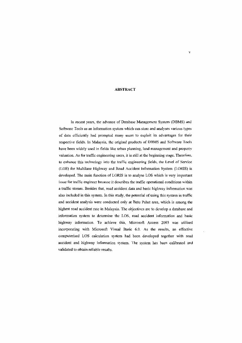
ABSTRACT
In recent years, the advance of Database Management System (DBMS) and
Software Tools as an information system which can store and analyses various types
of data efficiently had prompted many users to exploit its advantages for their
respective fields. In Malaysia, the original products of DBMS and Software Tools
have been widely used in fields like urban planning, land management and property
valuation. As for traffic engineering users, it is still at the beginning stage. Therefore,
to enhance this technology into the traffic engineering fields, the Level of Service
(LOS) for Multilane Highway and Road Accident Information System (LORIS) is
developed. The main function of LORIS is to analyse LOS which is very important
issue for traffic engineer because it describes the traffic operational conditions within
a traffic stream. Besides that, road accident data and basic highway information was
also included in this system. In this study, the potential of using this system in traffic
and accident analysis were conducted only at Batu Pahat area, which is among the
highest road accident rate in Malaysia. The objectives are to develop a database and
information system to determine the LOS, road accident information and basic
highway information. To achieve this, Microsoft Access 2003 was utilised
incorporating with Microsoft Visual Basic 6.0. As the results, an effective
computerised LOS calculation system had been developed together with road
accident and highway information system. The system has been calibrated and
validated to obtain reliable results.

\I
ABSTRAK
Kebelakangan ini, kelebihan Sistem Pengurusan Pangkalan Data (DBMS)
dan Perkakasan Perisian sebagai sistem maklumat yang boleh menyimpan dan
menganalisa pelbagai data secara berkesan telah menggalakkan rarnai pengguna
mempraktikkannya dalam bidang yang mereka ceburi. Di Malaysia, produk yang
dihasilkan daripada DBMS dan Perkakasan Peri sian telah digunakan secara meluas
dalam bidang seperti perancangan bandar, pengurusan tanah dan penilaian harta.
Manakala penggunaannya dalam bidang kejuruteraan lalulintas masih pada peringkat
awal. Oleh itu, untuk mengaplikasikan teknologi ini dalam kejuruteraan lalulintas,
sistem Tahap Perkhidmatan untuk Lebuhraya Berbilang Lorong dan Maklumat
Kemalangan Jalanraya (LORIS) telah diperkenalkan. Fungsi utarna LORIS adalah
untuk menganalisa tahap perkhidmatan jalan (LOS) bagi mengenalpasti keadaan
aliran bagi sesuatu lalulintas. Selain itu, maklumat kemalangan jalanraya dan
maklumat asas jalanraya juga disertakan dalam sistem ini. Kawasan kajian bagi
mengukur kebolehan sistem ini adalah di daerah Batu Pahat yang merupakan antara
kawasan yang mempunyai kadar kemalangan yang tertinggi di Malaysia. Objektif
bagi kajian ini adalah untuk membina pangkalan data dan sistem maklumat bagi
menentukan LOS, menyimpan maklumat kemalangan jalanraya dan maklumat asas
jalanraya. Bagi merealisasikannya, kombinasi Microsoft Access 2003 dan Microsoft
Visual Basic 6.0 telah digunakan. Hasilnya, sebuah sistem berkomputer yang efektif
melibatkan pengiraan LOS yang digabungkan dengan sistem maklumat asas
jalanraya dan juga sistem maklumat kemalanganjalanraya. Sistem ini juga telah diuji
dan disahkan bagi mendapatkan keputusan yang tepat.
YI1
T ABLE OF CONTENTS
CHAPTER TITLE PAGES
THESIS VALIDATION
SUPERVISOR'S DECLARATION
TITLE
DEC LARA TION II
DEDICATION 111
ACKNOWLEDGEMENT IV
ABSTRACT V
ABSTRAK VI
TABLE OF CONTENTS VII
LIST OF TABLES XI
LIST OF FIGURES XII
LIST OF SYMBOLS XIV
LIST OF APPENDICES xv
viii
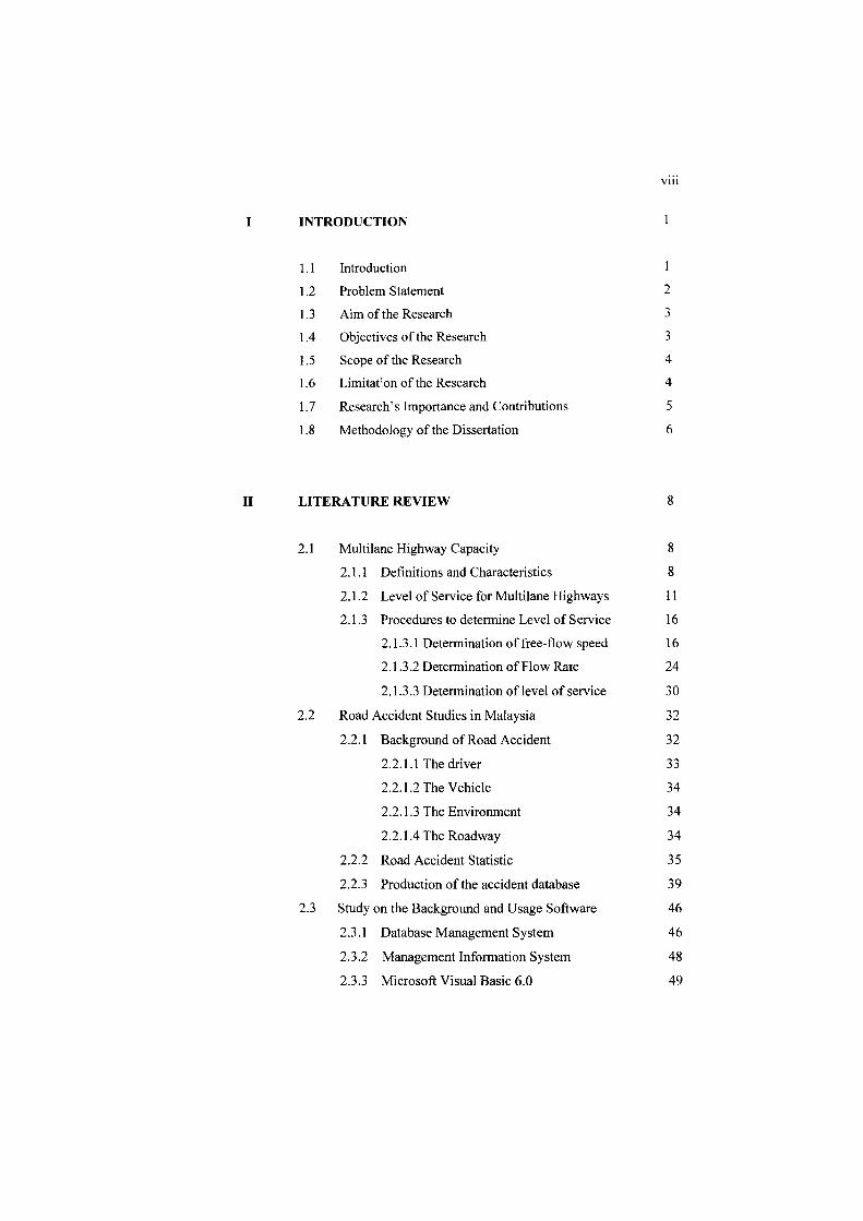
I INTRODUCTION
1.1 Introduction
1.2 Problem Statement 2
1.3 Aim of the Research 3
1.4 Objectives of the Research 3
1.5 Scope of the Research 4
1.6 Limitat;on of the Research 4
1.7 Research's Importance and Contributions 5
1.8 Methodology of the Dissertation 6
II LITERATURE REVIEW 8
2.1 Multilane Highway Capacity 8
2.1.1 Definitions and Characteristics 8
2.1.2 Level of Service for Multilane Highways 11
2.1.3 Procedures to determine Level of Service 16
2.1.3.1 Determination offree-flow speed 16
2.1.3.2 Determination of Flow Rate 24
2.1.3.3 Determination of level of service 30
2.2 Road Accident Studies in Malaysia 32
2.2.1 Background of Road Accident 32
2.2.1.1 The driver 33
2.2.1.2 The Vehicle 34
2.2.1.3 The Environment 34
2.2.1.4 The Roadway 34
2.2.2 Road Accident Statistic 35
2.2.3 Production of the accident database 39
2.3 Study on the Background and Usage Software 46
2.3.1 Database Management System 46
2.3.2 Management Information System 48
2.3.3 Microsoft Visual Basic 6.0 49

III
IV
2.3.4 Microsoft Access 2003
2.3.5 Study on the Existing Software
2.3.5.1 HCS-Multilane
2.2.5.2 HIGHPLAN
RESEARCH METHODOLOGY
3.1 Introduction
3.2 System Development Life Cycle (SDLC)
3.3 Waterfall Model
3.3.1 Phase I: Feasibility and System Planning
3.3.2 Phase II: Requirement Analysis
3.3.2.1 Requirement Identification
3.3.2.2 Requirement Analysis
3.3.2.3 Determination of Requirement
3.3.2.4 Requirement Specification
3.3.3 Phase III: System Design
3.3.4 Phase IV: Coding
3.3.5 Phase V: Program Testing
3.3.6 Phase VI: Operation and Maintenance
RESUL TS AND ANALYSIS
4.1
4.2
4.3
4.4
Introduction
Main Il'terface Display
Administrator Part
The User Part
IX
52
54
54
54
57
57
58
59
60
60
61
62
69
69
69
70
71
72
73
73
74
76
82

x
V FINDING ANALYSIS 84
5.0 Introduction 84
5.1 Section A: Administration System Design 85
5.2 Section B: Design Presentation 86
5.3 Section C: Design Calculation 87
5.4 Section D: Design Information 88
5.5 Section E: Overall System Design 89
5.6 Conclusions 90
VI CONCLUSION AND RECOMMENDATION 91
6.1 Introduction 91
6.2 Comparison of advantages and disadvantages
of the methodology used 92
6.2.1 The Advantages of the Waterfall model
as SDLC 92
6.2.2 The Disadvantages of the Waterfall
model as SDLC 93
6.3 Comparison of the Advantages and the
Disadvantages of LORIS 93
6.3.1 The Advantages of LORIS 93
6.3.2 The Disadvantages of LORIS 94
6.4 Conclusions 95
6.5 Recommendations 96
BIBLIOGRAPHY 97
APPENDIX 102

XI
LIST OF TABLES
NO. TITLE PAGES
2.1 LOS Criteria for Multilane Highway 20
2.2 Adjustment for Lane Width 21
2.3 Adjustment for Lateral Clearance 22
2.4 Adjustment for Median Type 22
2.5 Access-Point Density Adjustment 23
2.6 Passenger-Car Equivalent on Extended General Highway
Segments 27
2.7 Passenger-Car Equivalents for Truck and Buses on Uniform
Upgrades 28
2.8 Passenger-Car Equivalents for RVs on Uniform Upgrades 29
2.9 Passenger-Car Equivalents for Trucks on Downgrades 29
2.10 Worst Ranking by Weightage from 1999 - 2001 38
5.1 Level of Influenced based on Score Min Range 85
5.2 Level of influence in assisting administrator of PWD 86
5.3 Level of influence for presentation design 87
5.4 Level of influence for calculation design 88
5.5 Level of influence for information design 89
5.6 Level of influence of overall system design 90
Xli
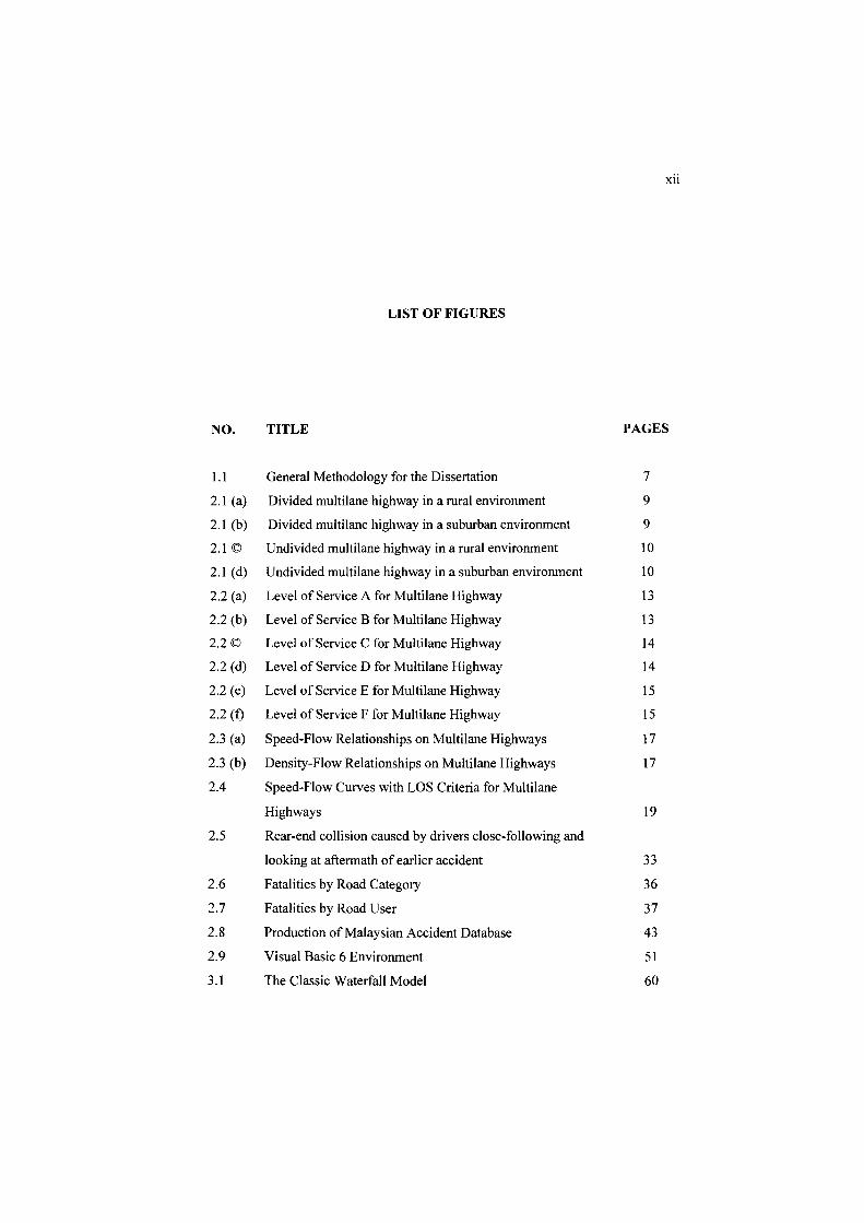
LIST OF FIGURES
NO. TITLE PAGES
1.1 General Methodology for the Dissertation 7
2.1 (a) Divided multilane highway in a rural environment 9
2.1 (b) Divided multilane highway in a suburban environment 9
2.1 © Undivided multilane highway in a rural environment 10
2.1 (d) Undivided multilane highway in a suburban environment 10
2.2 (a) Level of Service A for Multilane Highway 13
2.2 (b) Level of Service B for Multilane Highway 13
2.2© Level of Service C for Multilane Highway 14
2.2 (d) Level of Service D for Multilane Highway 14
2.2 (e) Level of Service E for Multilane Highway 15
2.2 (0 Level of Service F for Multilane Highway 15
2.3 (a) Speed-Flow Relationships on Multilane Highways 17
2.3 (b) Density-Flow Relationships on Multilane Highways 17
2.4 Speed-Flow Curves with LOS Criteria for Multilane
Highways 19
2.5 Rear-end collision caused by drivers close-following and
looking at aftermath of earlier accident 33
2.6 Fatalities by Road Category 36
2.7 Fatalities by Road User 37
2.8 Production of Malaysian Accident Database 43
2.9 Visual Basic 6 Environment 51
3.1 The Classic Waterfall Model 60
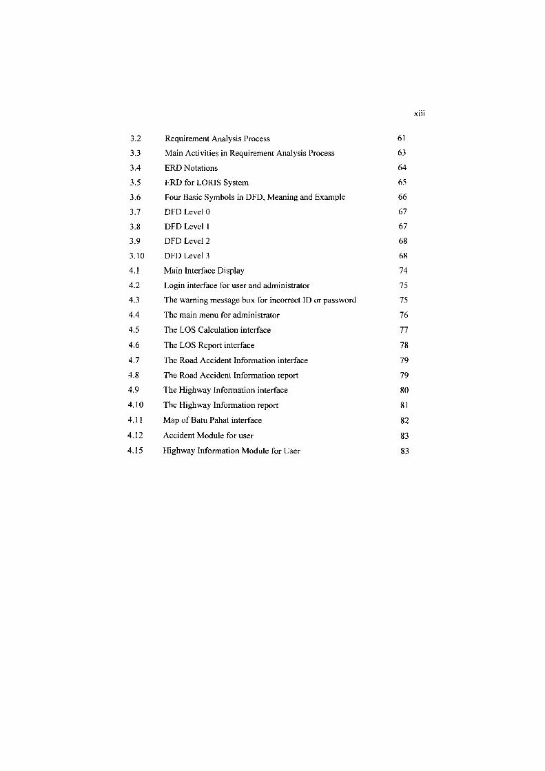
X 111
3.2 Requirement Analysis Process 61
3.3 Main Activities in Requirement Analysis Process 63
3.4 ERD Notations 64
3.5 ERD for LORIS System 65
3.6 Four Basic Symbols in DFD, Meaning and Example 66
3.7 DFD Level 0 67
3.8 DFD Levell 67
3.9 DFD Level 2 68
3.10 DFD Level 3 68
4.1 Main Interface Display 74
4.2 Login interface for user and administrator 75
4.3 The warning message box for incorrect ID or password 75
4.4 The main menu for administrator 76
4.5 The LOS Calculation interface 77
4.6 The LOS Report interface 78
4.7 The Road Accident Information interface 79
4.8 The Road Accident Information report 79
4.9 The Highway Information interface 80
4.10 The Highway Information report 81
4.11 Map of Batu Pahat interface 82
4.12 Accident Module for user 83
4.15 Highway Information Module for User 83
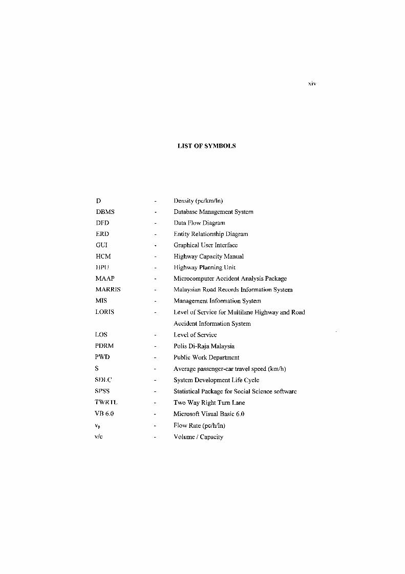
D
DBMS
DFD
ERD
GUI
HCM
HPU
MAAP
MARRIS
MIS
LORIS
LOS
PDRM
PWD
S
SDLC
SPSS
TWRTL
VB 6.0
vp
vic
LIST OF SYMBOLS
Density (pclkm!ln)
Database Management System
Data Flow Diagram
Entity Relationship Diagram
Graphical User Interface
Highway Capacity Manual
Highway Planning Unit
Microcomputer Accident Analysis Package
Malaysian Road Records Information System
Management Information System
Level of Service for Multilane Highway and Road
Accident Information System
Level of Service
Polis Di-Raja Malaysia
Public Work Department
Average passenger-car travel speed (krn/h)
System Development Life Cycle
Statistical Package for Social Science software
Two Way Right Turn Lane
Microsoft Visual Basic 6.0
Flow Rate (pclhlln)
Volume I Capacity
XIV
NO.
A
B
LIST OF APPENDIXES
TITLE
Questionnaire Form
Coding
xv
PAGES
1O:L
105

CHAPTER I
INTRODUCTION
1.1 Introduction
Twenty years ago only a limited number of practitioners had access to the
large-frame computers required to use computerised traffic modelling tools.
Highway or transportation departments, large metropolitan areas, universities, and
large companies were the fortunate few. Others had to use analytical, manual
techniques, or pay a high price for commercial computer services.
Now, microcomputers are as commonly available as the electronic calculators
of the 70s and, while more expensive than calculators, are easily within the economic
reach of virtually every transportation professional in most locations throughout the
world.
Developers of computerised traffic tools, such as the universities and private
organisations have promulgated a substantial suite of software tools for every phase
of transportation planning and engineering in the past decades.
The largest single group of software concerns traffic analysis, road accident
and basic highway information. Traffic analysis software tools have a wide range of
applications. Some of them provide an alternative to manual applications of widely

used highway capacity analysis procedures. Others utilise simulation for evaluation
of the impact of changing traffic patterns, geometric designs and control strategies.
Also a number of tools have imbedded optimisation capabilities to allow the
development of the best control strategies (Sabra, et al. 2000).
2
Despite the abundance of traffic operations software, the lack of
understanding of such software among the executive and management levels of the
transportation engineering profession has inhibited software applications. Many
public and private leaders in the profession do not know what software is available or
about its capabilities.
Besides the software tools, databases have been in use since the earliest days
of electronic computing in Malaysia, beginning with the custom programs written to
access custom databases. Today, modem systems can be applied to widely different
databases and needs, these systems were tightly linked to the database in order to
gain speed at the price of flexibility. The technology is widely used in many agencies
like the City Hall and Town Council as their town information system for territory
planning (Keat Leong, 1998).
1.2 Problem Statement
Before this research was done, several analysis on related problems and needs
have been identified such as time management for data collecting and data analysing.
Problem from time management; some data are stored in different source(s). It is
inconvenience if the data are at difference source(s) at the same time. On the analysis
side, user(s) have to spend more time on reference table while conducting the LOS
analysis.
1.3 Aim of the Research
The aim of the research is to design and develop a computerised system in
order to help user in accessing information and analysing LOS data accurately. The
system that had been developed will replace the existing manual system used by
traffic engineers and the person who involve in the road accident analysing process.
1.4 Objectives of the Research
Based on the stated problem statement, an information storage system is
needed to ensure all the data and information are organize. Therefore, the
maintenance and traffic system can be done easily. So, the objectives for this
research are:
1. to develop a database and information system for road accident
information and basic highway information,
ll. to create a user friendly system, i.e. to obtain information from the
provided databases, and
Ill. to develop a system, i.e to analyse the LOS for Multilane Highway.
3
1.5 Scope of tbe Researcb
The scope in this research covers the development of database that \\ ould be
able to determine the level of services (LOS) for a Multilane Highway. The analy sis
is based on Highway Capacity Manual. HCM 2000. Besides that. development of
database and information system for road accident and basic highway information
which is based on Malaysian Road Records Information System. MARRIS 200()
Report was also included. The study area used in this study is the Batu Pahat district.
1.6 Limitation of the Research
This research limitation is basically due to the time constraint to perform the
study. The problems occur because of the data needed are stored at different
government department. The other reasons are the data are manually stored and the
existing system is not very user friendly. Hence, the limitations of this research are:
I. the LOS system, the analysis is for the operational and planning only,
n. database development for road accident and highway information system is
for expressway, federal and state roads in Batu Pahat only,
iii. sample of accident data is only from I sl June 2005 to 30lh June 2005.
1.7 Research's Importance and Contributions
This research fulfils the need of the person who involves in analyzing and
manages the traffic system in Batu Pahat. The existing manual system will be
replaced by the computerised system:
Therefore, the contributions of this research are:
(i) to simplify the management information process,
(ii) to assist the traffic engineer or traffic analyst to analyse the Level of
Service (LOS) easily and accurately,
(iii) to provide a secured database system with a security protection,
(iv) to reduce the used of paper in order to create a paperless society in
managing and anal) sing traffic and road accident, and
(v) to provide automatic information browsing process.
5

6
1.8 Methodology of the Study
Generally the methodology for this study is shown in Figure 1.1. During
initial stage, work planning process were done to determine the problems in analyses,
collecting and management data for Level of Service (LOS) for Multilane Highway
and road accident in Batu Pahat. Observations show that the works is done manually.
Based on these problems, methods of analysis were planned and listed. Then,
a plan to identify the related data and information that needed for this researched was
done. This is to ensure the smooth process in collecting all the sources.
The next process was to analyse the data and information that were collected
from the specific agencies and departments. Then the databases and system
development was done by using Microsoft Access 2003 and Visual Basic 6.0 There
were two types of data in this system which are graphic and non graphic data. The
map of Batu Pahat has been used as graphical data while road accident information
and basic highway information had been used as non graphical data.
The system has undergone several testing to improve its capability. There
were minor and major corrections before the system is completed. Besides that, the
system was also tested by samples of users based on the given questionnaire. Lastly,
the conclusions and recommendations were made for this researched.