Embed Size (px)
Citation preview
11768 Federal Register / Vol. 60, No. 41 / Thursday, March 2, 1995 / Proposed Rules
DEPARTMENT OF THE INTERIOR
Fish and Wildlife Service
50 CFR Part 17
RIN 1018–AD10
Endangered and Threatened Wildlifeand Plants; Proposed Designation ofCritical Habitat for the Pacific CoastPopulation of the Western SnowyPlover
AGENCY: Fish and Wildlife Service,Interior.ACTION: Proposed rule.
SUMMARY: The U.S. Fish and WildlifeService (Service) proposes to designate28 areas along the coast of California,Oregon, and Washington as criticalhabitat for the Pacific coast vertebratepopulation segment of the westernsnowy plover (Charadrius alexandrinusnivosus). This small shorebird is listedas a threatened species under theEndangered Species Act of 1973, asamended (Act). Critical habitatdesignation would provide additionalprotection under section 7 of the Actwith regard to activities that requireFederal agency action. As required bysection 4 of the Act, the Service willconsider economic and other relevantimpacts prior to making a final decisionon the size and configuration of criticalhabitat.DATES: Comments from all interestedparties must be received by May 31,1995. Public hearing requests must bereceived by April 17, 1995.ADDRESSES: Comments and materialsconcerning this proposal should be sentto Joel Medlin, Field Supervisor, U.S.Fish and Wildlife Service, SacramentoField Office, 2800 Cottage Way, RoomE–1803, Sacramento, CA 95825–1846.Comments and materials received willbe available for public inspection, byappointment, during normal businesshours at the above address.FOR FURTHER INFORMATION CONTACT: Ms.Karen J. Miller, Sacramento Field Office(see ADDRESSES section) telephone 916/979–2725, facsimile 916/979–2723.
SUPPLEMENTARY INFORMATION:
Background
Previous Federal ActionsOn March 24, 1988, the Service
received a petition from Dr. J.P. Myersof the National Audubon Society to listthe Pacific coast population of thewestern snowy plover as a threatenedspecies under the Act. On November 14,1988, the Service published a 90-daypetition finding (53 FR 45788) thatsubstantial information had been
presented indicating the requestedaction may be warranted. At that time,the Service acknowledged thatquestions pertaining to the demarcationof the subspecies and significance ofinterchange between coastal and interiorstocks of the subspecies remained to beanswered. Public comments wererequested on the status of the coastalpopulation of the western snowy plover.A status review of the entire subspecieshad been in progress since the Service’sDecember 30, 1982, Vertebrate Notice ofReview (47 FR 58454). In that notice, asin subsequent notices of review(September 18, 1985 (50 FR 37958);January 6, 1989 (54 FR 554)), thewestern snowy plover was included asa category 2 candidate. Category 2encompasses species for whichinformation now in possession of theService indicates that proposing to listas endangered or threatened is possiblyappropriate, but for which conclusivedata on biological vulnerability andthreat are not currently available tosupport proposed rules. The publiccomment period on the petition wasclosed on July 11, 1989 (54 FR 26811,June 26, 1989).
In September 1989, the Servicecompleted a status report on the westernsnowy plover. Based on the bestscientific and commercial dataavailable, including commentssubmitted during the status review, theService made a 12-month petitionfinding on June 25, 1990, that thepetitioned action was warranted butprecluded by other pending listingactions, in accordance with section4(b)(3)(B)(iii) of the Act.
On January 14, 1992 (57 FR 1443), theService published a proposal to list thecoastal population of the western snowyplover as a threatened species. After areview of the best scientific andcommercial available and all commentsreceived in response to the proposedrule, the Service published a final ruleto list the coastal population of thewestern snowy plover as a threatenedspecies on March 5, 1993 (58 FR 12864),and thereby activated the protectionsapplicable to listed species. The Servicedid not propose to designate criticalhabitat for the snowy plover within theproposed or final listing rulemakingbecause the Service found that criticalhabitat was not then determinable. TheService now has the information neededfor a critical habitat proposal.
Ecological ConsiderationsThe western snowy plover, which is
one of twelve subspecies of the snowyplover (Rittinghaus 1961 in Jacobs1986), is a small, pale colored shorebirdwith dark patches on either side of the
upper breast. The species was firstdescribed in 1758 by Linnaeus(American Ornithologists’ Union 1957).For a complete discussion of the ecologyand life history of this subspecies, seethe Service’s March 5, 1993, final rulelisting the coastal population of thewestern snowy plover as a threatenedspecies (58 FR 12864).
The Pacific coast population of thewestern snowy plover breeds in loosecolonies primarily on coastal beachesfrom southern Washington to southernBaja California, Mexico. On the Pacificcoast, larger concentrations of breedingbirds occur in the south than in thenorth, suggesting that the center of theplovers’ coastal distribution lies closerto the southern boundary of California(Page and Stenzel 1981). In BajaCalifornia, Mexico, snowy plovers aredistributed across 28 sites, withconcentrations at six coastal lakes (Dra.Graciela De La Graza Garcia, DirectorGeneral of Conservation Ecology andNatural Resources, United States ofMexico, in litt., 1992). Other lesscommon nesting habitat includes saltpans, coastal dredged spoil disposalsites, dry salt ponds, and salt pondlevees and islands (Widrig 1980, Wilson1980, Page and Stenzel 1981). Sandspits, dune-backed beaches, unvegetatedbeach strands, open areas aroundestuaries, and beaches at river mouthsare the preferred coastal habitats fornesting (Stenzel et al. 1981, Wilson1980).
Based on the most recent surveys, atotal of 28 snowy plover breeding sitesor areas currently occur on the PacificCoast of the United States. Two sitesoccur in southern Washington—one atLeadbetter Point, in Willapa Bay(Widrig 1980), and the other at DamonPoint, in Grays Harbor (Anthony 1985).In Oregon, nesting birds were recordedin 6 locations in 1990 with 3 sites(Bayocean Spit, North Spit Coos Bayand spoils, and Bandon State Park-Floras Lake) supporting 81 percent ofthe total coastal nesting population(Oregon Department of Fish andWildlife, unpubl. data, 1991). A total of20 plover breeding areas currently occurin coastal California (Page et al. 1991).Eight areas support 78 percent of theCalifornia coastal breeding population:San Francisco Bay, Monterey Bay,Morro Bay, the Callendar-Mussel RockDunes area, the Point Sal to PointConception area, the Oxnard lowland,Santa Rosa Island, and San NicolasIsland (Page et al. 1991).
The coastal population of the westernsnowy plover consists of both residentand migratory birds. Some birds winterin the same areas used for breeding(Warriner et al. 1986, Wilson-Jacobs,
11769Federal Register / Vol. 60, No. 41 / Thursday, March 2, 1995 / Proposed Rules
pers. comm. in Page et al. 1986). Otherbirds migrate either north or south towintering areas (Warriner et al. 1986).Plovers occasionally winter in southerncoastal Washington (Brittell et al. 1976).The recent discovery of snowy ploverswintering near Cape Shoalwater inPacific County, Washington, representsthe northernmost record of winteringsnowy plovers on the Pacific coast(Scott Richardson, WashingtonDepartment of Wildlife, pers. comm.,1994). From 43 to 81 plovers winteredon the Oregon coast between 1982–1990, primarily on 3 beach segments(Oregon Department of Fish andWildlife 1994). The majority of birds,however, winter south of Bodega Bay,California (Page et al. 1986). Winteringplovers occur in widely scatteredlocations on both coasts of BajaCalifornia and significant numbers havebeen observed on the mainland coast ofMexico at least as far south as San Blas,Nayarit (Page et al. 1986). Many interiorbirds west of the Rocky Mountainswinter on the Pacific coast (Page et al.1986, Stern et al. 1988). Birds winter inhabitats similar to those used during thenesting season.
Widely varying nest success(percentage of nests hatching at leastone egg) and reproductive success(number of young fledged per female,pair, or nest) are reported in theliterature. Nest success ranges from 0 to80 percent for coastal snowy plovers(Widrig 1980, Wilson 1980, Saul 1982,Wilson-Jacobs and Dorsey 1985,Wickham unpubl. data in Jacobs 1986,Warriner et al. 1986). Instances of lownest success have been attributed to avariety of factors, including predation,human disturbance, and inclementweather conditions. Reproductivesuccess ranges from 0.05 to 2.40 youngfledged per female, pair or nest (Page etal. 1977, Widrig 1980, Wilson 1980,Saul 1982, Warriner et al. 1986, Page1988). Page et al. (1977) estimated thatsnowy plovers must fledge 0.8 youngper female to maintain a stablepopulation. Reproductive success fallsfar short of this threshold at manynesting sites (Widrig 1980, Wilson 1980,Warriner et al. 1986, Page 1988, Page1990).
Management ConsiderationsHistoric records indicate that nesting
western snowy plovers were once morewidely distributed in coastal California,Oregon, and Washington than they arecurrently. In coastal California, snowyplovers bred at 53 locations prior to1970 (Page and Stenzel 1981). Since thattime, no evidence of breeding birds hasbeen found at 33 of these 53 sites,representing a 62 percent decline in
breeding sites (Page and Stenzel 1981).The greatest losses of breeding habitatwere in southern California, within thecentral portion of the snowy plover’scoastal breeding range. In Oregon,snowy plovers historically nested at 29locations on the coast (Charles Bruce,Oregon Department of Fish andWildlife, pers. comm., 1991). In 1990only 6 nesting colonies remained,representing a 79 percent decline inactive breeding sites. In Washington,snowy plovers formerly nested in atleast 5 sites on the coast (Eric Cummins,pers. comm., 1991). Today only 2colony sites remain active, representing,at minimum, a 60 percent decline inbreeding sites.
In addition to loss of nesting sites, theplover breeding population inCalifornia, Oregon, and Washington hasdeclined 17 percent between 1977 and1989 (Page et al. 1991). Declines in thebreeding population have beenspecifically documented in Oregon andCalifornia. Breeding season surveysalong the Oregon coast from 1978 to1993 show that the number of adultsnowy plovers has declinedsignificantly at an average annual rate ofabout 7 percent (Oregon Department ofFish and Wildlife 1994). The number ofadults has declined from a high of 142adults in 1981 to a low of 30 adults in1992 (Oregon Department of Fish andWildlife 1994; Randy Fisher, OregonDepartment of Fish and Wildlife, in litt.,1992). If the current trend continues,breeding snowy plovers could disappearfrom coastal Oregon by 1999. In 1981,the coastal California breedingpopulation of snowy plovers wasestimated to be 1,565 adults (Page andStenzel 1981). In 1989, surveys revealed1,386 plovers (Page et al. 1991), an 11percent decline in the breedingpopulation. The population decline inCalifornia may be greater thanindicated; the 1989 survey results areconsidered more reliable than the earlierestimates, which may haveunderestimated the overall populationsize (Gary Page, pers. comm., 1991).
Although there are no historic data forWashington, it is doubtful that thesnowy plover breeding population inWashington was ever very large (Brittellet al. 1976). However, loss of nestingsites in this state probably has resultedin a reduction in their overallpopulation size. In recent years, fewerthan 30 birds have nested on thesouthern coast of Washington (JamesAtkinson, pers. comm, 1990; EricCummins, pers. comm., 1991). In 1991,only one successful brood was detectedin the State (Tom Juelson, WashingtonDepartment of Wildlife, in litt., 1992).
Survey data also indicate a decline inwintering snowy plovers, particularly insouthern California. The number ofsnowy plovers observed duringChristmas Bird Counts from 1962 to1984 significantly decreased in southernCalifornia despite an increase inobserver participation in the counts(Page et al. 1986). This observed declinewas not accompanied by a significantloss of wintering habitat over the sametime period (Page et al. 1986).
The most important form of habitatloss to coastal breeding snowy plovershas been encroachment of Europeanbeachgrass (Ammophila arenaria). Thisnon-native plant was introduced to thewest coast around 1898 to stabilizedunes (Wiedemann 1987). Since then ithas spread up and down the coast andnow is found from British Columbia tosouthern California (Ventura County).European beachgrass is currently amajor dune plant at about 50 percent ofCalifornia breeding sites and all of thosein Oregon and Washington (J.P. Myers,National Audubon Society, in litt.,1988). Stabilizing sand dunes withEuropean beachgrass has reduced theamount of unvegetated area above thetideline, decreased the width of thebeach, and increased its slope. Thesechanges have reduced the amount ofpotential snowy plover nesting habitaton many beaches and may hamperbrood movements. The beachgrasscommunity also provides habitat forsnowy plover predators that historicallywould have been largely precluded bythe lack of cover in the dunecommunity. Cost effective methods tocontrol or eradicate Europeanbeachgrass have not yet been found.
In the habitat remaining for snowyplover nesting, human activity (e.g.,walking, jogging, running pets,horseback riding, off-road vehicle use,and beach raking) is a key factor in theongoing decline in snowy plover coastalbreeding sites and breeding populationsin California, Oregon, and Washington.The nesting season of the westernsnowy plover (mid-March to mid-September) coincides with the season ofgreatest human use on beaches of thewest coast (Memorial Day through LaborDay). Human activities detrimental tonesting snowy plovers includeunintentional disturbance andtrampling of eggs and chicks by peopleand unleashed pets (Stenzel et al. 1981,Warriner et al. 1986, P. Persons, in litt.,1992), off-road vehicle use (Widrig1980, Stenzel et al. 1981, Anthony 1985,Warriner et al. 1986, Page 1988, PhilipPersons, in litt., 1992); horseback riding(Woolington 1985, Page 1988, PhilipPersons, in litt., 1992); and beach raking(Stenzel et al. 1981). Page et al. (1977)
11770 Federal Register / Vol. 60, No. 41 / Thursday, March 2, 1995 / Proposed Rules
found that snowy plovers weredisturbed more than twice as often bysuch human activities than all othernatural causes combined.
In the few instances where humanintrusion into snowy plover nestingareas has been precluded either througharea closures or by natural events,nesting success has improved. Theaverage number of young fledged pernesting pair increased from 0.75 to 2.00after the nesting site at Leadbetter Point,Washington was closed to humanactivities (Saul 1982). Similarly, vehicleclosure on a portion of Pismo Beach,California, led to an eight-fold increasein the nesting plover population (W.David Shuford, Point Reyes BirdObservatory, in litt., 1989). After beachaccess was virtually eliminated by the1989 earthquake, fledging successincreased 16 percent at Moss LandingBeach, California (Page 1990).
Predation by mammalian and avianpredators is a major concern at anumber of nesting sites. Western snowyplover eggs, chicks, and adults are takenby a variety of avian and mammalianpredators. These losses, particularly toavian predators, are exacerbated byhuman disturbances. Of the manypredators, American crows (Corvusbrachyrhynchos), ravens (C. corax), andred fox (Vulpes) have had a significantlyadverse effect on reproductive successat several colony sites (Wilson-Jacobsand Meslow 1984, Page 1988, John andJane Warriner, Point Reyes BirdObservatory, in litt., 1989, Page 1990,Stern et al. 1991). Accumulation of trashat beaches attracts these as well as otherpredators (Stern et al. 1990, Hogan1991).
At most active breeding sites fewmeasures have been implementedspecifically to protect snowy plovers.Artificial measures have been used atseveral nesting sites to improve snowyplover nesting success. In 1991, theCalifornia Department of Parks andRecreation and the Service conductedplover nest enclosure studies onNational Wildlife Refuge and Stateproperty in the Monterey area. Hatchingsuccess of plover nests in enclosureswas 81 percent as compared to 28percent for unprotected nests (RichardG. Rayburn, California Department ofParks and Recreation, in litt., 1992,Elaine Harding-Smith, U.S. Fish andWildlife Service, pers. comm., 1992).Use of nest enclosures at Coos BayNorth Spit resulted in up to 88 percentnesting success, compared to as low as9 percent success for unprotected nests(Stern et al. 1991, Randy Fisher, in litt.,1992). Nest enclosures continue to beused at the above sites. The Servicerecently finalized a predator
management plan for Salinas RiverNational Wildlife Refuge, whichproposes management measures toreduce red fox populations on theRefuge (Parker and Takekawa 1993).
In a few areas in California, includingthe Marine Corps Base at CampPendleton, plovers have benefittedsomewhat from protective measurestaken for the endangered California leasttern (Sterna antillarum browni). AtVandenberg Air Force Base in southernCalifornia, beaches are closed to all footand vehicular traffic during the leasttern nesting season (Donna Brewer, U.S.Fish and Wildlife Service, pers. comm.,1991). Dogs and cattle have beenrestricted from some beaches at PointReyes National Seashore (Gary Page,pers. comm., 1991), and some beacheson Federal land in Oregon have beenclosed to vehicles to protect plovers andother wildlife (Charles Bruce, pers.comm., 1991). Leadbetter Point inWashington (Fish and Wildlife Service),a 5-acre spoil disposal site in Coos Bay(Bureau of Land Management), and a 25-acre spoil disposal site in Coos Bay(Corps of Engineers) are the only nestingsites where human access has beenrestricted in the past specifically forplover nesting. In 1993, at OregonDunes National Recreation Area, theForest Service used temporary fencingand signing to direct beach visitorsaway from snowy plover nesting areas.At Coos Bay, Oregon, the Corps ofEngineers is proposing two projects tocreate or improve plover nesting habitatusing dredged spoils.
Relationship to Recovery
Section 2(c)(1) of the Act declares that‘‘all Federal departments and agenciesshall seek to conserve endangered andthreatened species and shall utilize theirauthorities in furtherance of thepurposes of this Act.’’ Section 3(3) ofthe Act defines conservation as the useof all methods and procedures neededto recover an endangered or threatenedspecies to the point at which it nolonger needs to be listed under the Act.The Act mandates the conservation oflisted species through differentmechanisms, such as section 7(requiring Federal agencies to furtherthe purposes of the Act by carrying outconservation programs and insuring thatFederal actions will not likelyjeopardize the continued existence oflisted species or result in thedestruction or adverse modification ofdesignated critical habitat); section 9(prohibition of taking of listed species);section 10 (wildlife research permits,and other permits based on conservationplans); section 6 (cooperative
agreements and Federal grants); section5 (land acquisition); and research.
A recovery plan under section 4(f) ofthe Act is the ‘‘umbrella’’ thateventually guides all of these activitiesand promotes species’ conservation andeventual delisting. Recovery plansprovide guidance, which may includepopulation goals and identification ofareas in need of protection or specialmanagement, so that the species’ statusmay improve to where it may beremoved from the list of endangered andthreatened wildlife and plants. Recoveryplans usually include managementrecommendations for areas proposed ordesignated as critical habitat.
The Service considers theconservation of a species in adesignation of critical habitat. Thedesignation of critical habitat will not,in itself, result in the recovery of thespecies, but is one of several measuresavailable to contribute to conservationof the species. Critical habitat helpsfocus conservation activities byidentifying areas that contain essentialhabitat features (primary constituentelements) that require specialmanagement. The protection givencritical habitat under section 7 alsoimmediately increases the protectiongiven to these primary constituentelements and essential areas andpreserves options for the long-termconservation of the species. Theprotection of these areas may alsoshorten the time needed to achieverecovery. Designation of critical habitatalso heightens the awareness of thepublic and agencies of speciesconservation needs.
Designating critical habitat does notcreate a management plan, establishnumerical population goals, or prescribespecific management actions, and it hasno direct effect on areas not designated.Specific management recommendationsfor critical habitat are addressed inrecovery plans, management plans, andsection 7 consultations. Areas outside ofcritical habitat also may have animportant role in conservation of alisted species. A designation of criticalhabitat may be reevaluated and revisedat any time that new informationindicates changes are warranted. Inconsidering whether to designatecritical habitat, the Service will evaluatewhether land management plans,recovery plans, or other conservationstrategies have been developed and fullyimplemented that may reduce the needfor the additional protection providedby a critical habitat designation.
11771Federal Register / Vol. 60, No. 41 / Thursday, March 2, 1995 / Proposed Rules
Critical Habitat
DefinitionCritical habitat, as defined by section
3 of the Act (16 U.S.C. 1532) means (i)the specific areas within thegeographical area occupied by a speciesat the time it is listed on which arefound those physical or biologicalfeatures (I) essential to the conservationof the species and (II) which mayrequire special managementconsiderations or protection; and (ii)specific areas outside the geographicalarea occupied by the species at the timeit is listed, upon determination thatsuch areas are essential for theconservation of the species. The term‘‘conservation’’ as defined in section3(3) of the Act, means ‘‘to use and theuse of all methods and procedureswhich are necessary to bring anyendangered species or threatenedspecies to the point at which themeasures provided pursuant to this Actare no longer necessary.’’ 16 U.S.C.1532(3). Critical habitat, then, is toinclude biologically suitable areasnecessary to recovery of the species.Critical habitat may be proposed forspecies that are already listed asthreatened or endangered. Section 3further states that in most cases theentire range of a species should not beencompassed within critical habitat.
Primary Constituent ElementsThe Act requires critical habitat
designations to be based on the bestscientific data available 16 U.S.C.1533(a)(2). In determining what areasare critical habitat, the Service considersthose physical and biological attributesthat are essential to the conservation ofthe species and that may require specialmanagement considerations orprotection. Such requirements include,but are not limited to, the following (1)Space for individual and populationgrowth, and normal behavior; (2) food,water, or other nutritional orphysiological requirements; (3) cover orshelter; (4) sites for breeding,reproduction, rearing of offspring,germination, or seed dispersal; andgenerally (5) habitats that are protectedfrom disturbance or are representative ofthe historic, geographical, andecological distributions of a species (50CFR 424.12).
In considering the designation ofcritical habitat, the Service focuses onthe primary physical or biologicalconstituent elements of the area that areessential to the conservation of thespecies (50 CFR 424.12). Primaryconstituent elements may include, butare not limited to, roost sites, nestinggrounds, spawning sites, feeding sites,
seasonal wetland or dryland, waterquality or quantity, host species or plantpollinator, geological formation,vegetation type, tide, and specific soiltypes (50 CFR 424.12).
The proposed designation of criticalhabitat for the coastal population of thewestern snowy plover is based on thefollowing physical and biologicalfeatures and primary constituentelements:
* Space for individual and populationgrowth.
* Food, water, air, light, minerals, andother nutritional or physiologicalrequirements.
* Roost sites.* Sites for breeding, reproduction, and
rearing of offspring.* Habitats (nesting grounds and feeding
sites) that are protected from disturbance andare representative of the historic geographicaland ecological distribution of the species.
For all areas of critical habitatproposed for the plover, these physicaland biological features and primaryconstituent elements are provided orwill be provided by intertidal beaches(between mean low water and meanhigh tide), associated dune systems, andriver estuaries. Important components ofthe beach/dune/estuarine ecosysteminclude surf-cast kelp, sparselyvegetated foredunes, interdunal flats,spits, washover areas, blowouts,intertidal flats, salt flats, and flat rockyoutcrops. Several of these components(sparse vegetation, salt flats) aremimicked in artificial habitat types usedless commonly by snowy plovers (i.e.,dredge spoil sites and salt ponds andadjoining levees). Functional suitabilityof areas containing the features listedabove is also contingent upon isolationfrom human disturbance and predation.These attributes are considered essentialto the conservation of the coastalpopulation of the western snowy plover.
The primary constituent elements ofsnowy plover nesting, foraging, androosting habitat could occur on virtuallyevery beach along the Pacific coast.Therefore, biologically based criteriawere developed as a basis for furtheridentifying critical habitat areas andrelated recovery objectives. The keycomponents of site importance as itrelates to recovery of the species wereexisting nesting capacity, winteringcapacity, and geographic location.Those sites in Washington, Oregon, andCalifornia that currently support themajority of breeding and winteringwestern snowy plovers were initiallyselected for critical habitat designation.Several additional sites in Californiawere selected for designation to avoid alarge gap in the geographic distributionof breeding or wintering birds.
Important nesting and wintering siteswere identified from Page and Stenzel(1981), Page et al. (1986), Page et al.(1991), Washington Department ofWildlife (1993), and Oregon Departmentof Fish and Wildlife (1994); and throughpersonal communications withprofessionals in the field.
Proposed Critical Habitat DesignationThe Service has identified 28 critical
habitat areas totalling approximately20,000 acres and about 210 miles ofcoastline, or about 10 percent of thecoastline of California, Oregon, andWashington. Of the 28 areas, 19 criticalhabitat areas are proposed in California,7 in Oregon, and 2 in Washington.Within the last decade, these sitesprovided habitat for about 65 percent ofnesting and 60 percent of winteringwestern snowy plovers in California; 95percent of nesting and 95 percent ofwintering plovers in Oregon; and 100percent of nesting and about 90 percentof wintering plovers in Washington.Protection and special management ofthese sites are essential to recovery ofthe coastal population of the westernsnowy plover and will form thecornerstone of a recovery plan.
In California, approximately 25percent of proposed critical habitatoccurs on Federal lands. About 50percent of critical habitat proposed onnon-Federal lands is State-owned, withthe California Department of Parks andRecreation being the primary landmanager. In Oregon about 45 percent ofproposed critical habitat areas occurs onFederal land with the remaindercontrolled primarily by State agencies.Of the two sites proposed in the Stateof Washington, one is State property,and the second includes State landsadjacent to Willapa National WildlifeRefuge.
The Service excluded from proposedcritical habitat designation, lands thatalready provide adequate protection forthe western snowy plover. These sitesinclude lands that provide plovernesting and wintering habitat withinthree National Wildlife Refugecomplexes—Willapa National WildlifeRefuge in Washington, and SalinasNational Wildlife Refuge and theSouthern California Coastal Complex inCalifornia. Programs currently exist onthese refuges to protect snowy plovers.Also excluded are lands owned and/ormanaged by the National Park Service.Important plover nesting areas onNational Park Service lands (such asSanta Rosa Island) are relativelyinaccessible by the public. Anyrecreational use impacts or otheridentifiable impacts on breeding andwintering birds or their habitat would
11772 Federal Register / Vol. 60, No. 41 / Thursday, March 2, 1995 / Proposed Rules
be covered through the section 7consultation process. Also excluded arekey nesting areas on Camp Pendleton inSan Diego County, California. Aprogrammatic consultation currentlyunderway between the Service and theDepartment of the Navy will addressany adverse effects to nesting ploversand their habitat. For the above sites,therefore, designation of critical habitatwould provide no additional benefit tothe species. Prior to making a finaldecision on this proposal the Servicewill continue to consider whetherexisting management provides adequateprotection for nesting and winteringwestern snowy plovers. For example,we are working with the ResourcesAgency of California to identifyCalifornia State Park lands in thisproposal that are currently providingadequate protection for these birds. TheService may exclude adequatelyprotected sites from designation.
The Service also excluded fromproposed critical habitat sites thatwould significantly conflict with thesurvival and recovery objectives of otherlisted species. Significant conflicts wereidentified between the habitat needs ofsnowy plovers and biological objectivesfor the California clapper rail (Ralluslongirostris obsoletus), light-footedclapper rail (Rallus longirostris levipes),and salt marsh harvest mouse(Reithrodontomys raviventris). The tworails and mouse are federally listedendangered species.
The California clapper rail and saltmarsh harvest mouse inhabit estuarinemarshes of San Francisco Bay. Over 90percent of historic tidal marsh habitat inthe Bay has been lost, primarily throughthe development of commercial saltponds (Josselyn 1983). Western snowyplovers have taken advantage of thisartificial salt pond habitat, primarily insouth San Francisco Bay, and nest onlevees or islands within active saltponds or in abandoned dry salt ponds.This artificial habitat supports thelargest subpopulation of snowy ploverswithin its range (Page et al. 1991). Thissame habitat, with the exception of twosalt pond sites used by nesting snowyplovers, however, is identified in therecovery plan for the California clapperrail and salt marsh harvest mouse forrestoration to historic tidal marsh (U.S.Fish and Wildlife Service 1984; PeterSorensen, Fish and Wildlife Service,pers. comm., 1994).
The light-footed clapper rail inhabitscoastal tidal marshes from Santa BarbaraCounty south to Baja California, Mexico.Over two-thirds of historic tidal marshhabitat has been lost (Speth 1971)primarily to urban development, floodcontrol, and oil development. Several
sites in Ventura, Orange, and San DiegoCounties provide nesting and/orwintering habitat for snowy plovers, butalso provide high quality clapper railhabitat or represent high priority tidalmarsh restoration sites in the light-footed clapper rail recovery plan (U.S.Fish and Wildlife Service 1985). Thesesites are Bolsa Chica, Agua HediondaLagoon, Batiquitos Lagoon, San ElijoLagoon, San Dieguito Lagoon, LosPenasquitos Lagoon, the San DiegoRiver mouth, and the marshes of southSan Diego Bay. Because the light-footedclapper rail is endangered and thehabitat needs of this species differsignificantly from those of the westernsnowy plover, the Service is excludingthese sites from critical habitatdesignation.
Overall, this proposal focuses theprimary recovery objectives for thewestern snowy plover on coastal beachand dune habitats, which represent asignificant proportion of natural nestingand wintering habitat of the coastalpopulation of the western snowy plover.These natural habitats, therefore, areconsidered essential to conservation ofthis threatened species. Protection ofthese sites as well as plover habitat onFish and Wildlife Service, National ParkService, and Navy lands at CampPendleton will provide addedprotection for about 76 percent ofnesting and 65 percent of winteringplovers rangewide. Sites excluded fromcritical habitat designation for thevarious reasons given above should notbe considered as unnecessary toconservation of the species. Therecovery plan for the coastal populationof the western snowy plover willaddress the value of these areas tospecies’ recovery. At the present time,these excluded sites support about 20percent of the coastal population of thewestern snowy plover and during therecovery process may provide birds tosupplement populations in essentialbreeding and wintering areas. Iffocusing recovery on the 28 proposedcritical habitat areas provesunattainable, additional sites may beproposed as critical habitat in the futureto aid in recovery of the species.
At this time, conservation of thePacific coast population of the westernsnowy plover requires sufficientmanagement efforts at all sites proposedas critical habitat. However, newinformation that may be grounds forreview of this determination includes,but is not limited to, data showing thatthe species is more or less vulnerablethan currently thought, a change in thespecies’ status due to catastrophicevents such as disease or weather, or
evidence that continuing efforts toconserve the species are insufficient.
Many of the proposed critical habitatareas include large expanses of beach.For proposed sites that support nestingsnowy plovers, nesting colonies mayoccupy only a small portion of theproposed critical habitat area. The largercritical habitat area is needed, however,because foraging occurs throughout theintertidal and foredune portions of thebeach. Designation of larger criticalhabitat areas also will allow for naturalshifting of plover nesting colonies as aresult of vegetational changes andweather related events that reconfiguresuitable nesting habitat.
Regulations governing designation ofcritical habitat (50 CFR 424 12(h)) statethat critical habitat shall not bedesignated within foreign countries.Although the Pacific coast population ofthe western snowy plover’s breedingand wintering range extends intoMexico, no critical habitat is proposedoutside United States jurisdiction.
Effects of Critical Habitat DesignationSection 4(b)(8) of the Act requires, for
any proposed or final regulation thatdesignates critical habitat, a briefdescription and evaluation of thoseactivities (public or private) that mayadversely modify such habitat or may beaffected by such designation.Regulations found at 50 CFR 402.02define destruction or adversemodification of critical habitat as adirect or indirect alteration thatappreciably diminishes the value ofcritical habitat for both the survival andrecovery of a listed species. Suchalterations include, but are not limitedto, alterations adversely modifying anyof those physical or biological featuresthat were the basis for determining thehabitat to be critical, that is, its primaryconstituent elements.
An activity will not adversely modifyan area within designated criticalhabitat that does not contain anyconstituent elements. For example,existing areas such as parking lots,paved roads, and various kinds ofstructures within the proposed criticalhabitat boundaries clearly would notfurnish habitat or biological features forwestern snowy plovers. Furthermore,some activities would not be restrictedby critical habitat designation becausethey would have no significant adverseeffect on the primary constituentelements.
Activities that may adversely modifycritical habitat are subject to regulationunder section 7(a) of the Act if they arecarried out, authorized, or funded by aFederal agency. The purpose ofconsultations between the Service and
11773Federal Register / Vol. 60, No. 41 / Thursday, March 2, 1995 / Proposed Rules
other Federal agencies is to ensure thatactivities are carried out in a mannerthat is not likely to jeopardize thecontinued existence of listed species oradversely modify or destroy its criticalhabitat. Regulations implementing thisinteragency cooperation provision of theAct are codified at 50 CFR part 402.Section 7(a)(4) of the Act and 50 CFR402.10 of the regulations, requireFederal agencies to confer informallywith the Service on any action that islikely to result in destruction or adversemodification of proposed criticalhabitat.
Activities areas that could adverselyaffect proposed critical habitat of thecoastal population of the western snowyplover fall into seven general categories:
(1) projects or management activities thatcause, induce, or increase human-associateddisturbance on beaches, including operationof off-road vehicles on the beach and beachcleaning. These activities may reduce thefunctional suitability of nesting, foraging, androosting areas. Activities that may adverselymodify critical habitat areas that supportwintering birds (September 15–February 29)include beach cleaning that removes surfcastkelp and driftwood, dogs off leash, off-roadvehicle driven at night, and falcon flying.Activities within posted fenced or otherwiseprotected nesting areas (March 1–September14) that may adversely modify critical habitatareas include camping, off-road vehicle use(day or night), walking, jogging, clam digging,pets on or off leash, livestock grazing,sunbathing, picnicking, horseback riding,hang gliding, kite flying, model airplaneflying, beach cleaning, and falcon flying in orover active nesting areas. With very fewexceptions, the nesting area is a smallfraction of the entire beach. Thus, no morethat 5 to 15 percent of the vast majority ofthe units would be removed from these kindsof public uses during the breeding season.The Service would work with landowners todevelop signs or fencing or other means toprotect these small nesting areas.Furthermore, western snowy plovers occupythe soft sandy portions of the upper beach orforedunes, and people tend to prefer lowerbeach or sand that is regularly washed by thetides. On a case by case basis, the fewrestrictions could be removed after theplovers had finished breeding or leftwintering grounds.
(2) actions that would promote unnaturalrates or sources of predation. For example,producing human-generated litter thatattracts predators, or designing exclosuresthat promote perching by avian predatorsmay adversely modify critical habitat byreducing its functional suitability to supportnesting snowy plovers.
(3) actions that would promote theinvasion of non-native vegetation.
(4) activities associated with maintenanceand operation of salt ponds. Activities thatmay adversely modify or destroy criticalhabitat when conducted during the snowyplover nesting season include floodinginactive salt ponds; raising the water level inactive salt ponds; grading, resurfacing,
riprapping, or placing dredged spoils onlevees; and driving maintenance vehicles onlevees. However, levee maintenanceactivities also may benefit snowy plovers byproviding vegetation-free habitat for nesting.The Service would work with landowners toavoid harmful activities during the breedingseason.
(5) dredge spoil disposal activities that mayadversely modify critical habitat whenconducted during the nesting season includedeposition of spoil material, laying of pipesto transport the material, and use ofmachinery to spread the material. However,dredge spoil disposal sites also may benefitsnowy plovers by providing nesting habitatfree of European beachgrass. The Servicewould work with landowners to avoidharmful activities during the breedingseason.
(6) shoreline erosion control projects andactivities that may alter the topography of thebeach. Activities that may adversely modifyor destroy nesting, foraging, and roostinghabitat include beach nourishment (sanddeposition, spreading of sand withmachinery); construction of breakwaters andjetties (interruption of sand deposition); dunestabilization using native and non-nativevegetation or fencing (decreased beach width,increased beach slope, reduction in blowoutsand other preferred nesting habitat); beachleveling (increased tidal reach, removal ofsparse vegetation used by chicks for shelter,destruction of rackline feeding habitat).Beach nourishment projects, however, alsomay have the potential to benefit nesting orwintering plover habitat on some sitesexperiencing serious erosion. The Servicewould work with landowners to avoidharmful activities when the birds are present.
(7) contamination events. Contaminationthrough oil spills or chemical releases mayadversely modify critical habitat bycontaminating snowy plovers and/or theirfood sources.
Federal agencies that may be requiredto consult with the Service on one ormore of these activities include theForest Service, Bureau of LandManagement, Federal AviationAdministration, and the Departments ofthe Army (including the Corps ofEngineers), Navy, and Air Force.
In addition several other species thatare listed under the Act occur in thesame general areas as western snowyplovers. These species share the coastalbeach/dune/estuarine ecosystem withsnowy plovers. All of these speciesoccurred historically in association withwestern snowy plovers in this Pacificcoast ecosystem, and thus, the habitatrequirements of these species do notsignificantly conflict with those of thesnowy plover. Therefore, any plansprepared for sites designated as criticalhabitat for the snowy plover should beconsidered ecosystem managementplans that accommodate needs of otherlisted or proposed species that alsooccur on the site. In doing so, theseproposed snowy plover critical habitat
areas more aptly represent criticalhabitat for a multitude of speciesinhabiting the coastal beach/dune/estuarine ecosystem. Federal agenciesproposing management actions for otherlisted species may affect critical habitatfor the western snowy plover and berequired to initiate formal consultationunder section 7 of the Act. Conversely,proposed management actions for thebenefit of the plover or its habitat mayaffect other listed species. The Servicewill work with other Federal agencies todevelop ecosystem plans that providefor the needs of all listed species.
When the Service issues an opinionconcluding that a project is likely toresult in the destruction or adversemodification of critical habitat, theService also provides reasonable andprudent alternatives to the project, ifany are identifiable. Reasonable andprudent alternatives are defined at 50CFR 402.02 as alternative actionsidentified during formal consultationthat can be implemented in a mannerconsistent with the intended purpose ofthe action, that are consistent with thescope of the Federal agency’s legalauthority and jurisdiction, that areeconomically and technologicallyfeasible, and that the Director believeswould avoid resulting in the destructionor adverse modification of criticalhabitat. Reasonable and prudentalternatives can vary from slight projectmodifications to extensive redesign orrelocation of the project. Costsassociated with implementing areasonable and prudent alternative aresimilarly variable.
Consideration of Economic and OtherFactors
Section 4(b)(2) of the Act requires theService to consider economic and otherimpacts of designating any particulararea as critical habitat. For example,beneficial impacts of critical habitatdesignation may include (1) a clearnotification to Federal agencies and thepublic of the existence and importanceof critical habitat, (2) voluntaryincreased protection of snowy ploverson some private lands, (3) stimulation ofadditional attention to the requirementsof section 9 of the Act by private,municipal, county, and statelandowners, (4) additional protectionfor other listed and non-listed speciesthat occur in areas designated as criticalhabitat for the snowy plover, and (5)preservation of the beach-dune-estuarine ecosystem. Section 4(b)(2)authorizes the Service to exclude anyarea from critical habitat designation ifthe Service determines the benefits ofexcluding the area outweigh the benefitsof including it, except that the Service
11774 Federal Register / Vol. 60, No. 41 / Thursday, March 2, 1995 / Proposed Rules
may not exclude an area if the Servicedetermines that doing so would result inextinction of the species. Pursuant to 50CFR 424.19, the Service will considerthe economic and other relevantimpacts of designating of critical habitatfor the coastal population of the westernsnowy plover.
Economic AnalysisThe economic analysis is designed to
provide information to assist in makingdeterminations about areas which maybe excluded from critical habitat. It isconducted by examining how adesignation of critical habitat for thesnowy plover would be expected toaffect the use of Federal lands as wellas non-Federal activities authorized orfunded by Federal agencies. Activitieson private or state-owned lands that donot involve Federal permits, funding orother Federal actions would not berestricted by a designation of criticalhabitat.
The economic analysis distinguishesbetween economic effects caused by thelisting of the snowy plover as threatenedand those that would be caused by theproposed designation of critical habitat.Furthermore, if a proposed action wouldotherwise have been limited orprohibited by another statute orregulation, such as the Clean Water Act,those economic effects would not beattributable to either listing or criticalhabitat designation under theEndangered Species Act.
Economic effects are the costs orbenefits to society of precluding orlimiting specific land uses in areasbeing considered for designation ascritical habitat. Economic effects arecategorized as either efficiency ordistributional. Economic efficiencyeffects are those consequences of criticalhabitat designation that cause changesin national income. Economicdistribution effects pertain to regionalchanges that may have offsetting effectselsewhere in the national economy.Efficiency effects are used primarily todetermine whether an action iseconomically sound and whetherexpected benefits exceed costs.Distributional effects are used toevaluate regional and local economicimpacts.
Consultation Under Section 7 of theEndangered Species Act
Section 7 of the Act (16 USC 1536),requires Federal agencies to insure thatactivities they fund, authorize, or carryout are not likely to jeopardize thecontinued existence of listed species orresult in destruction or adversemodification of critical habitat. Jeopardyis defined at 50 CFR 402.02 as any
action reasonably expected to reduceappreciably the likelihood of both thesurvival and recovery of the species inthe wild by reducing its reproduction,numbers, or distribution. Destruction oradverse modification of critical habitatis defined at 50 CFR 402.02 as anydirect or indirect alteration thatappreciably diminishes the value ofcritical habitat for both the survival andrecovery of the species.
Under section 7, a Federal agencymust consult with the Service if itdetermines that an action may affect alisted species or its critical habitat.During consultation, the Service reviewsthe agency’s proposed action andprepares a biological opinion as towhether that action is likely tojeopardize the continued existence ofthe species or destroy or adverselymodify its critical habitat.
In cases where species are listedwithout critical habitat, the Servicedetermines only whether the proposedaction is likely to jeopardize thecontinued existence of the species. Incases where critical habitat has beendesignated, the Service also determineswhether the proposed action is likely todestroy or adversely modify criticalhabitat. The additional requirement forFederal agencies to avoid destructionand adverse modification of criticalhabitat may result in incrementalrestrictions on agency actions beyondthose required to avoid jeopardy or forother statutory or regulatory purposes.
The incremental restrictions arisingfrom section 7 consultations ondestruction or adverse modification arethe only way that designating criticalhabitat produces an economic impact.To isolate that incremental impact, totaleconomic effects of limitations on aproposed action within critical habitatmust be apportioned between a specieslisting (jeopardy, take prohibitions, etc.)and critical habitat designation(destruction or adverse modifications).
If the action is found to jeopardize thecontinued existence of the species ordestroy or adversely modify its criticalhabitat, the Service is required toprovide, to the extent possible,reasonable and prudent alternatives tothe proposed action. By definition,reasonable and prudent alternativesallow the proposed action to go forwardwhile removing the conditions thatjeopardize the species or destroy oradversely modify its critical habitat. Forthe snowy plover, the Service believesthat reasonable and prudent alternativesdeveloped as part of consultation willallow most activities to continue,subject to some limitations. Suchalternatives might include fencing orseasonal closure of certain areas to
human uses, as well as changes in beacherosion control or dredging plans.
Determination of whether an actionwill result in jeopardy and/or adversemodification is dependent upon anumber of factors, such as the type ofproject, its size, location, and duration.In many cases, sufficient managementactions will permit agencies to avoidadverse modification with little or noeffect on their activities. The Servicebelieves that, in the case of the snowyplover, the large majority of economicimpacts as a result of section 7consultation will occur as a result oflisting, through the application of thejeopardy standard and incidental takeprohibitions.
Framework of AnalysisThe economic analysis examines the
costs and benefits of precluding orlimiting specific land uses within areasdesignated as critical habitat. It is castin a ‘‘with’’ critical habitat versus a‘‘without’’ critical habitat frameworkand seeks to measure the net change inthe various categories of benefits andcosts when the critical habitatdesignation is imposed on the existingbaseline.
National and Regional EffectsThe economic effects of critical
habitat designation consist of thoseaffecting national income and those thatare important on a local or regionallevel.
National economic (efficiency) costsrepresent changes in national income(the total value of goods and services).They are measured as changes inconsumer surplus and producer surplus(economic rent). Economic efficiencyanalysis seeks to maximize nationalincome from a given resource base.Gains and losses in recreation values,increased costs imposed onmanagement agencies or developmentprojects, loss of earnings by displacedlabor or capital assets, and changes inrevenue from user fees (beach user fees,etc.) are typical national economic costsof critical habitat designation. Theeconomic cost of designating criticalhabitat includes any additional coststhat would be imposed, regardless ofwhether they are incurred by a Federalagency, a state agency or the privatesector so long as they stem from asection 7 consultation regardingdestruction or adverse modification ofthe habitat proposed to be designated.
Regional economic (distributional)impacts represent transfers betweenpeople, groups, or geographic regions,with no net effect on the national total.Distributional impacts relate to equityand fairness considerations and deal
11775Federal Register / Vol. 60, No. 41 / Thursday, March 2, 1995 / Proposed Rules
primarily with how income and wealthare divided among regions and groups.Changes in employment, householdincome and local or state tax revenuesare frequently used to portray regionaleffects.
A Net-Cost With and With-outApproach
Designation of critical habitat willoften result in both economic gains andlosses. Careful application of a with andwithout analytical framework will helpto distinguish between the two. Forexample, with critical habitat recreationsuch as bird watching may be preservedthat otherwise would have been lostbecause of a development project orcontinued habitat loss. The nationaleconomic value of the preservedrecreation and the regional jobs andhousehold income it produces are gains,or benefits, of designation. Withoutcritical habitat, an area may have beenused for developed recreationalpurposes, but critical habitatdesignation would prohibit those uses.The values and jobs associated with thatnow precluded use become a loss(benefit foregone) due to critical habitatdesignation. It is the net effect of thesechanges in both the national andregional accounts that is important.Describing what probably would havehappened to an area of potential criticalhabitat in both the with and withoutscenarios, both currently and in thefuture, is an important part of theanalysis. The availability of data limitsquantification of the net effects in manyinstances.
Baseline for AnalysisAs noted earlier, the economic effects
of critical habitat designation areincremental to those already created bythe Clean Water Act and other statutes,and by listing the snowy plover asthreatened. Actions taken for thoseother purposes establish the baseline forthis analysis. It is the marginal increasein species protection provided bydesignation of critical habitat and themarginal change in costs, regionalimpacts, and benefits that thedesignation produces that are relevantto this analysis.
Data RequirementsThe Service has notified Federal
agencies having jurisdiction over theareas being proposed as critical andasked them to estimate the effect ofdesignation on their activities. Eachagency was sent detailed maps and legaldescriptions of the proposed areas andasked to identify areas for which theywere responsible. They were then askedto provide detailed descriptions of
activities on those areas that may beaffected by critical habitat designation,in three situations:
Without Listing: Activities that wouldhave been taking place in the proposedarea if there had been no listing of thesnowy plover as threatened.
With Listing: Activities that would betaking place once any existing oranticipated restrictions to avoidjeopardy decisions in section 7consultations were put in place. Thislevel of activity becomes the baseline forevaluation of the incremental effect ofcritical habitat designation.
With Critical Habitat: Activitiesexpected to take place once anyanticipated restrictions to avoid adversemodification decisions in section 7consultations were put in place. Thedifference between this level and theWith-Listing level is the impactattributable to designating criticalhabitat.
Land management agencies wereasked to quantify their responses asmuch as possible in terms of days ofbeach use, cattle grazing, etc., and toestimate any change in their operationalcosts as a result of listing and ofdesignating critical habitat. OtherFederal agencies that may be affected bycritical habitat through their regulatoryor funding roles were also sent mapsand legal descriptions of the proposedcritical habitat and were asked if any ofthe areas were involved in pending oranticipated permit or funding actions.Responses to those requests will formthe empirical basis of the economicanalysis. The Service is also seekinginformation about such possible actionsduring the public comment period.
The Exclusion Process
This section summarizes theprocedure that will be followed prior toa final rule in determining whether ornot to exclude an area (or areas) fromdesignation as critical habitat for thewestern snowy plover. The criteria usedto help reach a determination and thesteps followed are described below.
Section 3(5)(A) of the EndangeredSpecies Act of 1973 (Act), as amended,generally defines critical habitat as:
(i) The specific areas within thegeographical area occupied by the species, atthe time it is listed * * * on which are foundthose physical or biological features (I)essential to the conservation of the speciesand (II) which may require specialmanagement considerations or protection.
Section 3 further states that in mostcases critical habitat will not encompassthe entire range of the species. The Actalso directs the Secretary to considereconomic and other relevant impacts in
the designation of critical habitat.Section 4(b)(2) states:
The Secretary shall designate criticalhabitat, and make revisions thereto * * * onthe basis of the best scientific data availableand after taking into consideration theeconomic impact, and any other relevantimpact, of specifying any particular area ascritical habitat. The Secretary may excludeany area from critical habitat if he determinesthat the benefits of such exclusion outweighthe benefits of specifying such area as part ofthe critical habitat, unless he determines,based on the best scientific and commercialdata available, that the failure to designatesuch area as critical habitat will result in theextinction of the species concerned.
Exclusion of an area as critical habitatwould only eliminate the protectionprovided by the destruction or adversemodification standard of section 7; itwould not alleviate the need to complywith other requirements of the Act inthat area, such as section 7 consultationon jeopardy and section 9 prohibitionson take. These requirements wouldapply regardless of whether or notcritical habitat is designated for aparticular area.
The authority to make determinationsunder section 4(b)(2) of the Act has beendelegated to the Director of the Fish andWildlife Service. Implementation ofsection 4(b)(2) requires threedeterminations: (1) The conservationbenefits to the species of including anarea as critical habitat, (2) the economicand other costs of including an area, and(3) the cumulative effects of exclusionson the probability of species extinction.If the exclusion of an area or areas fromcritical habitat would result in speciesextinction, then exclusion of the criticalhabitat area(s) would not be authorizedunder the Act.
The process used to evaluate criticalhabitat areas to determine whether thebenefits of exclusion outweigh thebenefits of inclusion as critical habitatcan be summarized in several sequentialsteps:Step 1 Identify areas that meet the
definition of critical habitat in section3(5) of the Act.
Step 2 Conduct an economic analysisto determine the anticipatedeconomic consequences ofdesignating areas as critical habitat.
Step 3 Identify the applicableeconomic, biological, and otherinformation that need to beconsidered to determine whether toretain, exclude, or modify areas ascritical habitat.For the western snowy plover, the
Service is proposing specific criticalhabitat areas that the Service believesare essential to the plovers’conservation. The biological value and

11776 Federal Register / Vol. 60, No. 41 / Thursday, March 2, 1995 / Proposed Rules
roles of each area in providingconservation benefits to the snowyplover have been identified in preparingthe proposal. An economic analysis willbe completed which estimates thepotential economic effects of proposingcritical habitat. The steps followed bythe Service in designating criticalhabitat and in assessing the potentialeconomic effects associated with adesignation of the proposed areas willbe fully described in the final rule andin the economic analysis report.
Public Comments Solicited
The Service intends that any finalaction resulting from this proposal willbe as accurate and as effective aspossible in the conservation ofendangered or threatened species andthe protection of critical habitat.Therefore, comments or suggestionsfrom the public, other concernedgovernmental agencies, the scientificcommunity, industry, or any otherinterested party concerning thisproposed rule are hereby solicited.Comments particularly are soughtconcerning:
(1) Reasons why any habitat (eitherexisting or additional areas) should orshould not be determined to be criticalhabitat as provided by section 4 of theAct;
(2) Current or planned activities andtheir possible impacts on proposedcritical habitat areas;
(3) Any foreseeable economic andother impacts resulting from theproposed designation of critical habitat;
(4) Economic values associated withbenefits of designating critical habitatfor the coastal population of the westernsnowy plover; and
(5) Information the Service might use,under section 4(b)(2) of the Act, indetermining whether the benefits ofexcluding an area from critical habitatoutweigh the benefits of specifying thearea as critical habitat.
Any final decision on this proposalwill take into consideration thecomments and any additionalinformation received by the Serviceduring the 60-day comment periodfollowing publication of this proposedrule. The final decision on designationof critical habitat also will include anyexclusion determinations.
The Endangered Species Act providesfor a public hearing on this proposal, ifrequested. Requests must be receivedwithin 45 days of the date of publicationof this proposal in the Federal Register.Such requests must be made in writingand should be sent to the FieldSupervisor, Sacramento Field Office(see ADDRESSES section).
National Environmental Policy Act
The Fish and Wildlife Service hasdetermined that an EnvironmentalAssessment and/or an EnvironmentalImpact Statement, as defined under theauthority of the National EnvironmentalPolicy Act of 1969, need not beprepared in connection with regulationsadopted pursuant to section 4(a) of theEndangered Species Act of 1973, asamended. A notice outlining theService’s reasons for this determinationwas published in the Federal Registeron October 25, 1983 (48 FR 49244).
Executive Order 12866 and RegulatoryFlexibility Act
This rule was reviewed by the Officeof Management and Budget underExecutive Order 12866. Based on theinformation discussed in this ruleconcerning public projects and privateactivities within critical habitat areas,there are no significant economicimpacts resulting from the criticalhabitat designation. There are a limitednumber of actions on private land thathave Federal involvement throughfunds or permits that may be affected bycritical habitat designation. Also, nodirect costs, enforcement costs,information collection, or recordkeepingrequirements are imposed on smallentities by this designation. Further, therule contains no recordkeepingrequirements as defined by thePaperwork Reduction Act of 1990. Thisrule does not require a Federalismassessment under Executive Order12612 because it would not have anysignificant federalism effects asdescribed in the order.
References Cited
American Ornithologists’ Union. 1957. TheA.O.U. checklist of North Americanbirds. Fifth edition. 168 pp.
Anthony, J.L. 1985. A report on thedistribution, numbers and humandisturbance of snowy plovers at DamonPoint, Washington. Report to theWashington Department of Game.Evergreen State College, Washington. 24pp.
Brittell, J.D., J.M. Brown, and R.L. Eaton.1976. Marine shoreline fauna ofWashington, Vol. II. WashingtonDepartment of Game and Ecology,Olympia, Washington. 341 pp.
Hogan, C. 1991. Snowy plover and humanactivities at Damon Point, Washington.May 1 to June 10, 1991. Unpubl. reportto Washington Department Wildlife,Olympia, Washington. 10 pp.
Jacobs, R.A. 1986. Snowy plover (Charadriusalexandrinus). Section 4.4.1, U.S. ArmyCorps of Engineers Wildlife ResourcesManagement Manual, Technical ReportEL–86–54, Portland, Oregon. 25 pp.
Josselyn, M. 1983. The ecology of SanFrancisco Bay tidal marshes: acommunity profile. Prepared for theNational Coastal Ecosystem Team, U.S.Fish and Wildlife Service, Slidell,Louisiana. 102 pp.
Oregon Department of Fish and Wildlife.1994. Final Draft. Oregon conservationprogram for the western snowy plover(Charadrius alexandrinus nivosus).Portland, Oregon. 56 pp.
Page, G.W. 1988. Nesting success of snowyplovers in central coastal California in1988. Report of the Point Reyes BirdObservatory, Stinson Beach, California. 7pp.
lll 1990. Nesting success of snowyplovers in central coastal California in1989 and 1990. Report of the Point ReyesBird Observatory, Stinson Beach,California. 13 pp.
Page, G.W., F.C. Bidstrup, R.J. Ramer, andL.E. Stenzel. 1986. Distribution ofwintering snowy plovers in Californiaand adjacent states. Western Birds17(4):145–170.
Page, G.W. and L.E. Stenzel (eds.). 1981. Thebreeding status of the snowy plover inCalifornia. Western Birds 12(1):1–40.
Page, G.W., L.E. Stenzel, W.D. Shuford, andC.R. Bruce. 1991. Distribution andabundance of the snowy plover on itswestern North American breedinggrounds. J. Field Ornithol. 62(2):245–255.
Page, G.W., J.S. Warriner, J.C. Warriner andR.M. Halbeisen. 1977. Status of thesnowy plover on the northern Californiacoast. Part I: Reproductive timing andsuccess. California Department of Fishand Game Nongame WildlifeInvestigations, Sacramento, California.10 pp.
Parker, M.W. and J.E. Takekawa. 1993.Salinas River National Wildlife Refugepredator management plan and finalenvironmental assessment. U.S. Fish andWildlife Service, San Francisco BayNational Wildlife Refuge, Newark,California. 56 pp.
Saul, S.M. 1982. Clam diggers and snowyplovers. Washington Wildl. 32(1):28–30.
Speth, J.W. 1971. The status of coastalwetlands in southern California. Paperpresented at annual meeting WesternSection of the Wildlife Society.
Stenzel, L.E., S.C. Peaslee, and G.W. Page.1981. II. Mainland Coast. Pages 6–16 inPage, G.W. and L.E. Stenzel, (eds.). Thebreeding status of the snowy plover inCalifornia. Western Birds 12(1):1–40.
Stern, M.A., K.A. Kristensen, and J.F.Morawski. 1988. Investigations of snowyplovers at Abert Lake, Lake Co., Oregon.Final Rept. for Oregon Department Fishand Wildlife Nongame Prog. 12 pp.
Stern, M.A., J.S. McIver, and G.A. Rosenberg.1990. Investigations of the westernsnowy plover at the Coos Bay North Spitand adjacent sites in Coos and CurryCounties, Oregon, 1990. Report toOregon Department Fish and WildlifeNongame Program 33 pp.
11777Federal Register / Vol. 60, No. 41 / Thursday, March 2, 1995 / Proposed Rules
Stern, M.A., J.S. McIver, and G.A. Rosenberg.1991. Nesting and reproductive successof snowy plovers along the south Oregoncoast 1991. Report to Oregon DepartmentFish and Wildlife Nongame Prog. 19 pp.
U. S. Fish and Wildlife Service. 1984. Saltmarsh harvest mouse and Californiaclapper rail recovery plan. Portland,Oregon. 141 pp.
U. S. Fish and Wildlife Service. 1985. Light-footed clapper rail recovery plan.Portland, Oregon. 121 pp.
Warriner, J.S., J.C. Warriner, G.W. Page, andL.E. Stenzel. 1986. Mating system andreproductive success of a smallpopulation of polygamous snowyplovers. Wilson Bull. 98(1):15–37.
Washington Department of Wildlife. 1993.Washington State recovery plan for thesnowy plover (Charadrius alexandrinus).Draft. 76 pp.
Widrig, R.S. 1980. Snowy plovers atLeadbetter Point. An opportunity forwildlife management? Prepared for theU.S. Fish and Wildlife Service, WillapaNational Wildlife Refuge, Ilwaco,Washington. 14 pp.
Wiedemann, A.M. 1987. The ecology ofEuropean beachgrass (Ammophilaarenaria (L.) Link). A review of theliterature. Oregon Department of Fishand Wildlife Nongame Wildlife ProgramTechnical Report #87–1–01. 18 pp.
Wilson, R.A. 1980. Snowy plover nestingecology on the Oregon coast. M.S.Thesis, Oregon State Univ., Corvallis,Oregon. 41 pp.
Wilson-Jacobs, R. and G.L. Dorsey. 1985.Snowy plover use of Coos Bay north spit,Oregon. Murrelet 66(3):75–81.
Wilson-Jacobs, R. and E.C. Meslow. 1984.Distribution, abundance, and nestingcharacteristics of snowy plovers on theOregon coast. Northwest Science58(1):40–48.
Woolington, M.C. 1985. A preliminaryinvestigation of the effect of recreationaluse on nesting snowy plovers at Suttonand Siltcoos beach areas, Oregon. OregonDepartment of Fish and WildlifeNongame Program. 37 pp.
Author: The primary author of thisproposed rule is Karen J. Miller, U.S. Fishand Wildlife Service, Sacramento FieldOffice, 2800 Cottage Way, Room E–1803,Sacramento, California 95825–1846 (916/979–2725).
List of Subjects in 50 CFR Part 17Endangered and threatened species,
Exports, Imports, Reporting andrecordkeeping requirements, andTransportation.
Proposed Regulation PromulgationAccordingly, it is hereby proposed to
amend part 17, subchapter B of chapter
I, title 50 of the Code of FederalRegulations, as set forth below:
PART 17—[AMENDED]
1. The authority citation for part 17continues to read as follows:
Authority: 16 USC 1361–1407; 16 USC1531–1544; 16 USC 4201–4245; Pub. L. 99–625, 100 Stat. 3500, unless otherwise noted.
§ 17.11 [Amended]
2. It is proposed to amend § 17.11(h)by revising the ‘‘critical habitat’’ entryfor ‘‘Plover, western snowy’’, underBIRDS, to read 17.95(b).
3. It is proposed to amend § 17.95(b)by adding, in the same alphabeticalorder as the species occurs in § 17.11(h),critical habitat of the Pacific coastpopulation of the western snowy plover(Charadrius alexandrinus nivosus) toread as follows.
§ 17.95 Critical habitat—fish and wildlife.
* * * * *(b) * * *
* * * * *
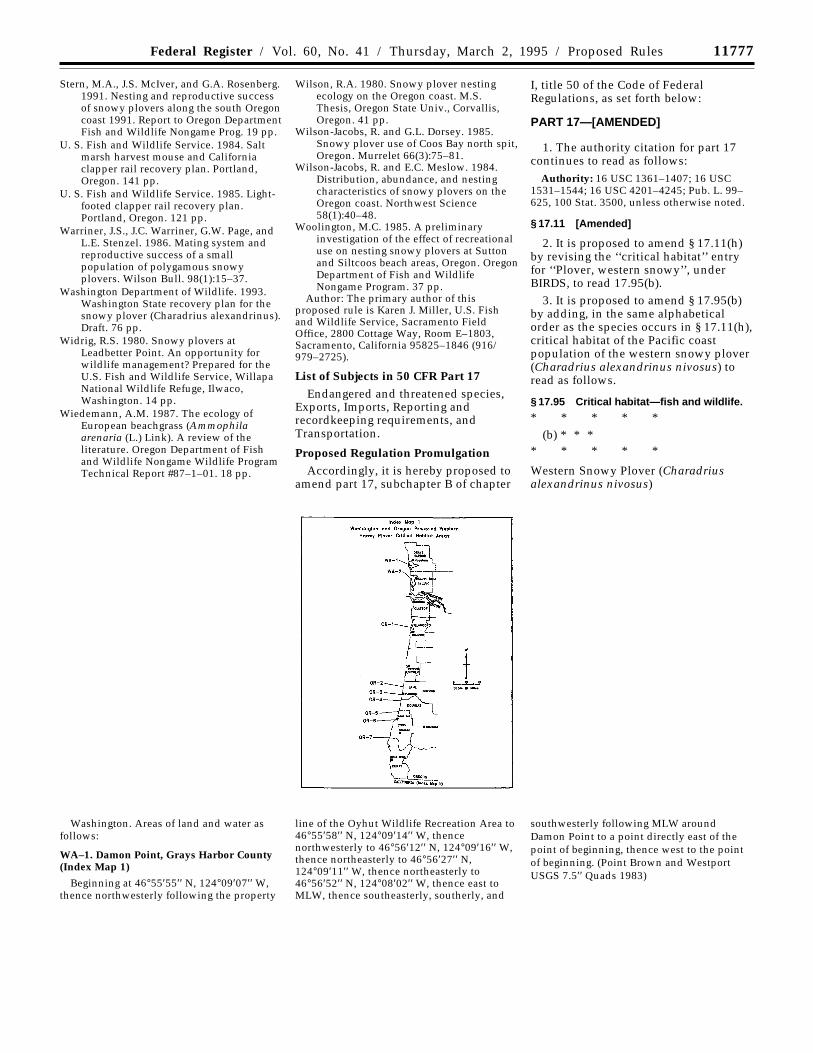
Western Snowy Plover (Charadriusalexandrinus nivosus)
Washington. Areas of land and water asfollows:
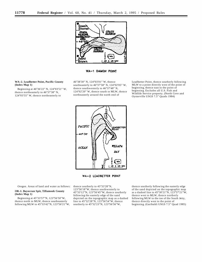
WA–1. Damon Point, Grays Harbor County(Index Map 1)
Beginning at 46°55′55′′ N, 124°09′07′′ W,thence northwesterly following the property
line of the Oyhut Wildlife Recreation Area to46°55′58′′ N, 124°09′14′′ W, thencenorthwesterly to 46°56′12′′ N, 124°09′16′′ W,thence northeasterly to 46°56′27′′ N,124°09′11′′ W, thence northeasterly to46°56′52′′ N, 124°08′02′′ W, thence east toMLW, thence southeasterly, southerly, and
southwesterly following MLW aroundDamon Point to a point directly east of thepoint of beginning, thence west to the pointof beginning. (Point Brown and WestportUSGS 7.5′′ Quads 1983)
11778 Federal Register / Vol. 60, No. 41 / Thursday, March 2, 1995 / Proposed Rules
WA–2. Leadbetter Point, Pacific County(Index Map 1)
Beginning at 46°36′22′′ N, 124°03′51′′ W,thence northeasterly to 46°37′38′′ N,124°03′55′′ W, thence northeasterly to
46°38′30′′ N, 124°03′01′′ W, thencesoutheasterly to 46°37′58′′ N, 124°02′05′′ W,thence southwesterly to 46°37′48′′ N,124°02′20′′ W, thence south to MLW, thencenortheasterly around the north end of
Leadbetter Point, thence southerly followingMLW to a point directly west of the point ofbeginning, thence east to the point ofbeginning. Excludes all U.S. Fish andWildlife Service property. (North Cove andOysterville USGS 7.5′′ Quads 1984)
Oregon. Areas of land and water as follows:
OR–1. Bayocean Spit, Tillamook County(Index Map 1)
Beginning at 45°33′57′′N, 123°56′50′′W,thence north to MLW, thence southeasterlyfollowing MLW to 45°33′42′′N, 123°56′21′′W,
thence southerly to 45°33′28′′N,123°56′18′′W, thence southwesterly to45°33′12′′N, 123°56′45′′W, thence southerlyfollowing the easterly edge of the sanddepicted on the topographic map as a dashedline to 45°32′28′′N, 123°56′54′′W, thencesoutherly to 45°32′23′′N, 123°56′56′′W,
thence southerly following the easterly edgeof the sand depicted on the topographic mapas a dashed line to 45°30′21′′N, 123°57′21′′W,thence west to MLW, thence northerlyfollowing MLW to the toe of the South Jetty,thence directly west to the point ofbeginning. (Garibaldi USGS 7.5′′ Quad 1985)
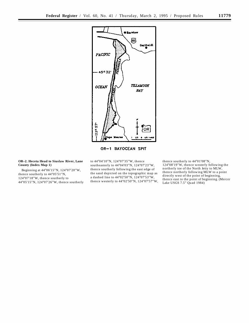
11779Federal Register / Vol. 60, No. 41 / Thursday, March 2, 1995 / Proposed Rules
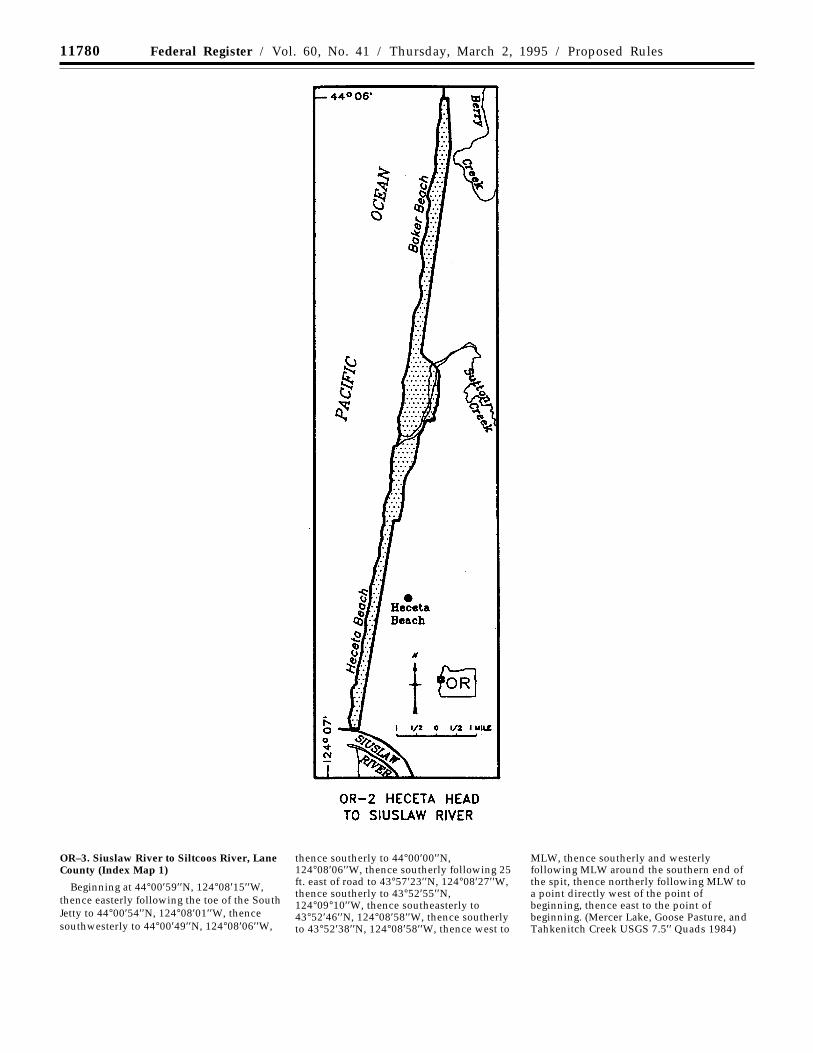
OR–2. Heceta Head to Siuslaw River, LaneCounty (Index Map 1)
Beginning at 44°06′15′′N, 124°07′20′′W,thence southerly to 44°05′51′′N,124°07′18′′W, thence southerly to44°05′15′′N, 124°07′26′′W, thence southerly
to 44°04′10′′N, 124°07′35′′W, thencesoutheasterly to 44°04′03′′N, 124°07′23′′W,thence southerly following the east edge ofthe sand depicted on the topographic map asa dashed line to 44°02′50′′N, 124°07′53′′W,thence westerly to 44°02′50′′N, 124°07′57′′W,
thence southerly to 44°01′08′′N,124°08′19′′W, thence westerly following thenortherly toe of the North Jetty to MLW,thence northerly following MLW to a pointdirectly west of the point of beginning,thence east to the point of beginning. (MercerLake USGS 7.5′′ Quad 1984)
11780 Federal Register / Vol. 60, No. 41 / Thursday, March 2, 1995 / Proposed Rules
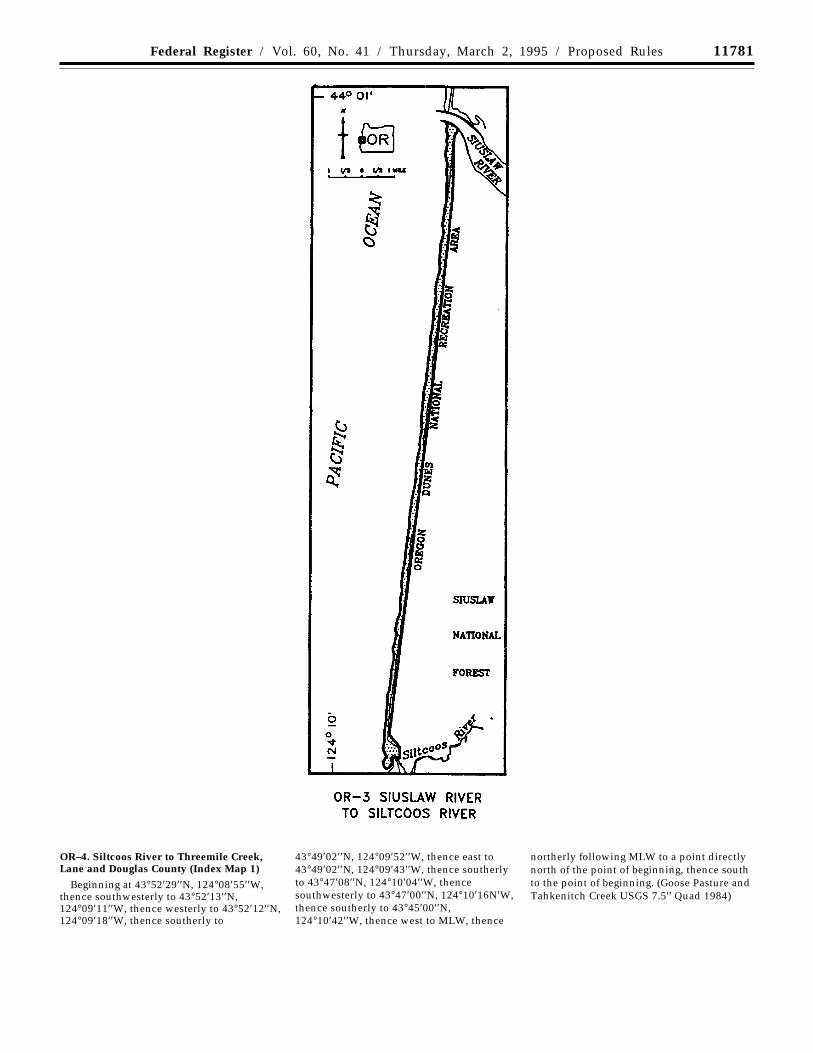
OR–3. Siuslaw River to Siltcoos River, LaneCounty (Index Map 1)
Beginning at 44°00′59′′N, 124°08′15′′W,thence easterly following the toe of the SouthJetty to 44°00′54′′N, 124°08′01′′W, thencesouthwesterly to 44°00′49′′N, 124°08′06′′W,
thence southerly to 44°00′00′′N,124°08′06′′W, thence southerly following 25ft. east of road to 43°57′23′′N, 124°08′27′′W,thence southerly to 43°52′55′′N,124°09°10′′W, thence southeasterly to43°52′46′′N, 124°08′58′′W, thence southerlyto 43°52′38′′N, 124°08′58′′W, thence west to
MLW, thence southerly and westerlyfollowing MLW around the southern end ofthe spit, thence northerly following MLW toa point directly west of the point ofbeginning, thence east to the point ofbeginning. (Mercer Lake, Goose Pasture, andTahkenitch Creek USGS 7.5′′ Quads 1984)
11781Federal Register / Vol. 60, No. 41 / Thursday, March 2, 1995 / Proposed Rules
OR–4. Siltcoos River to Threemile Creek,Lane and Douglas County (Index Map 1)
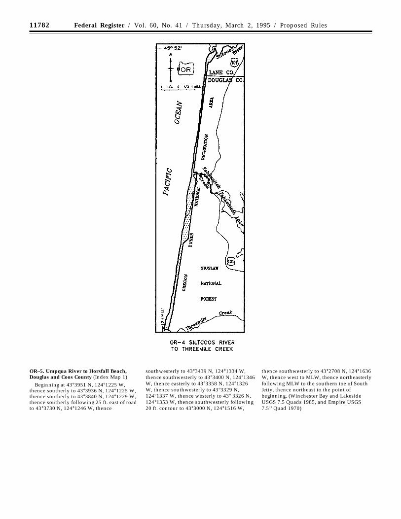
Beginning at 43°52′29′′N, 124°08′55′′W,thence southwesterly to 43°52′13′′N,124°09′11′′W, thence westerly to 43°52′12′′N,124°09′18′′W, thence southerly to
43°49′02′′N, 124°09′52′′W, thence east to43°49′02′′N, 124°09′43′′W, thence southerlyto 43°47′08′′N, 124°10′04′′W, thencesouthwesterly to 43°47′00′′N, 124°10′16N′W,thence southerly to 43°45′00′′N,124°10′42′′W, thence west to MLW, thence
northerly following MLW to a point directlynorth of the point of beginning, thence southto the point of beginning. (Goose Pasture andTahkenitch Creek USGS 7.5′′ Quad 1984)
11782 Federal Register / Vol. 60, No. 41 / Thursday, March 2, 1995 / Proposed Rules
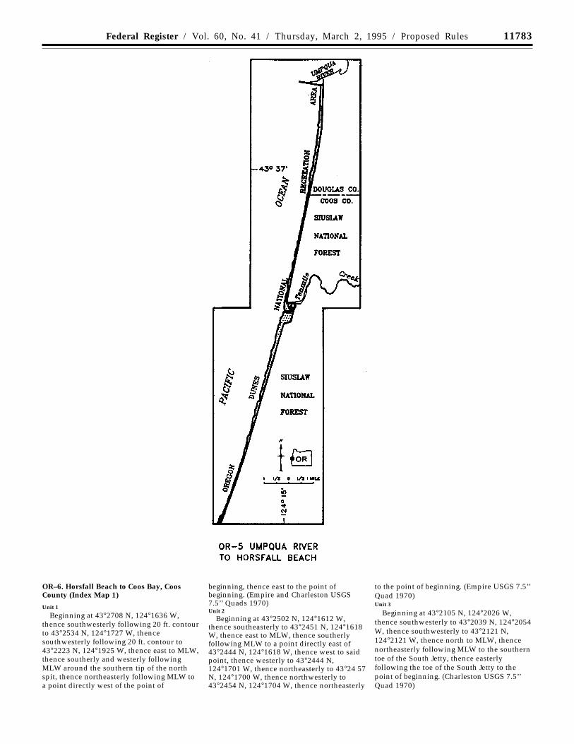
OR–5. Umpqua River to Horsfall Beach,Douglas and Coos County (Index Map 1)
Beginning at 43°3951 N, 124°1225 W,thence southerly to 43°3936 N, 124°1225 W,thence southerly to 43°3840 N, 124°1229 W,thence southerly following 25 ft. east of roadto 43°3730 N, 124°1246 W, thence
southwesterly to 43°3439 N, 124°1334 W,thence southwesterly to 43°3400 N, 124°1346W, thence easterly to 43°3358 N, 124°1326W, thence southwesterly to 43°3329 N,124°1337 W, thence westerly to 43° 3326 N,124°1353 W, thence southwesterly following20 ft. contour to 43°3000 N, 124°1516 W,
thence southwesterly to 43°2708 N, 124°1636W, thence west to MLW, thence northeasterlyfollowing MLW to the southern toe of SouthJetty, thence northeast to the point ofbeginning. (Winchester Bay and LakesideUSGS 7.5 Quads 1985, and Empire USGS7.5’’ Quad 1970)
11783Federal Register / Vol. 60, No. 41 / Thursday, March 2, 1995 / Proposed Rules
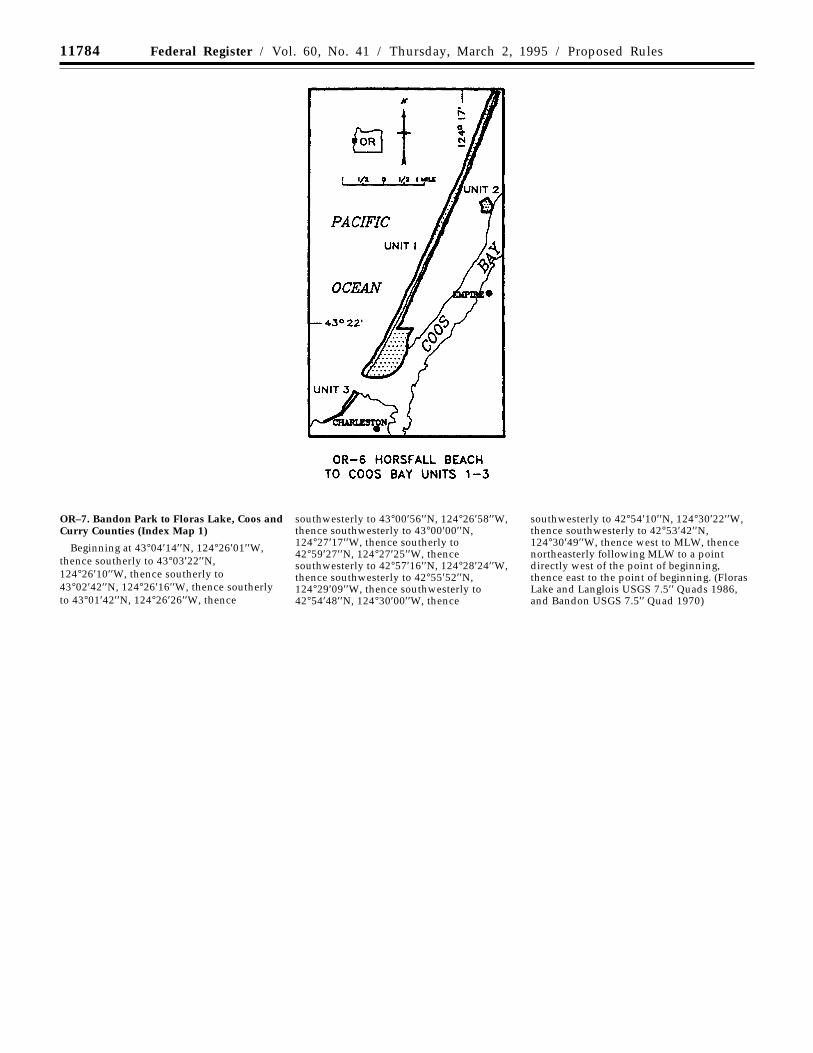
OR–6. Horsfall Beach to Coos Bay, CoosCounty (Index Map 1)
Unit 1
Beginning at 43°2708 N, 124°1636 W,thence southwesterly following 20 ft. contourto 43°2534 N, 124°1727 W, thencesouthwesterly following 20 ft. contour to43°2223 N, 124°1925 W, thence east to MLW,thence southerly and westerly followingMLW around the southern tip of the northspit, thence northeasterly following MLW toa point directly west of the point of
beginning, thence east to the point ofbeginning. (Empire and Charleston USGS7.5’’ Quads 1970)Unit 2
Beginning at 43°2502 N, 124°1612 W,thence southeasterly to 43°2451 N, 124°1618W, thence east to MLW, thence southerlyfollowing MLW to a point directly east of43°2444 N, 124°1618 W, thence west to saidpoint, thence westerly to 43°2444 N,124°1701 W, thence northeasterly to 43°24 57N, 124°1700 W, thence northwesterly to43°2454 N, 124°1704 W, thence northeasterly
to the point of beginning. (Empire USGS 7.5’’Quad 1970)Unit 3
Beginning at 43°2105 N, 124°2026 W,thence southwesterly to 43°2039 N, 124°2054W, thence southwesterly to 43°2121 N,124°2121 W, thence north to MLW, thencenortheasterly following MLW to the southerntoe of the South Jetty, thence easterlyfollowing the toe of the South Jetty to thepoint of beginning. (Charleston USGS 7.5’’Quad 1970)
11784 Federal Register / Vol. 60, No. 41 / Thursday, March 2, 1995 / Proposed Rules
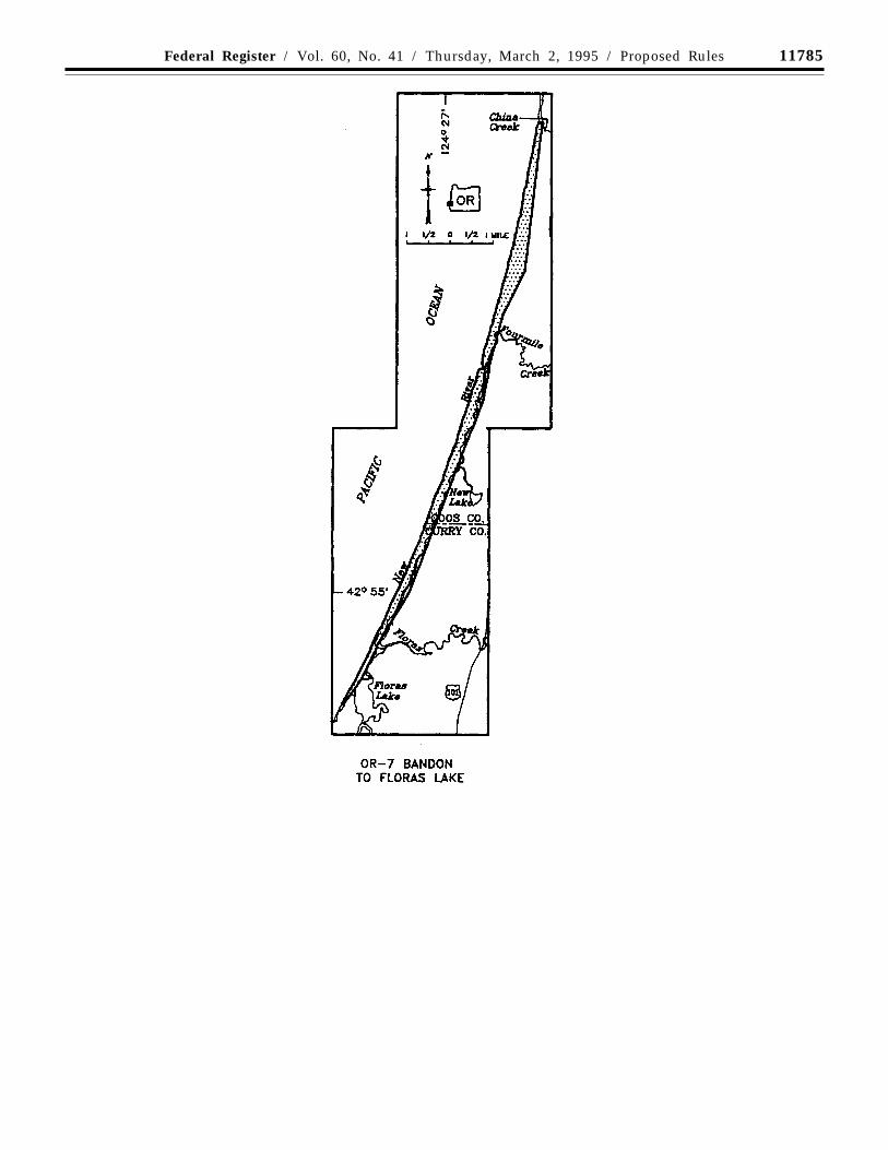
OR–7. Bandon Park to Floras Lake, Coos andCurry Counties (Index Map 1)
Beginning at 43°04′14′′N, 124°26′01′′W,thence southerly to 43°03′22′′N,124°26′10′′W, thence southerly to43°02′42′′N, 124°26′16′′W, thence southerlyto 43°01′42′′N, 124°26′26′′W, thence
southwesterly to 43°00′56′′N, 124°26′58′′W,thence southwesterly to 43°00′00′′N,124°27′17′′W, thence southerly to42°59′27′′N, 124°27′25′′W, thencesouthwesterly to 42°57′16′′N, 124°28′24′′W,thence southwesterly to 42°55′52′′N,124°29′09′′W, thence southwesterly to42°54′48′′N, 124°30′00′′W, thence
southwesterly to 42°54′10′′N, 124°30′22′′W,thence southwesterly to 42°53′42′′N,124°30′49′′W, thence west to MLW, thencenortheasterly following MLW to a pointdirectly west of the point of beginning,thence east to the point of beginning. (FlorasLake and Langlois USGS 7.5′′ Quads 1986,and Bandon USGS 7.5′′ Quad 1970)
11785Federal Register / Vol. 60, No. 41 / Thursday, March 2, 1995 / Proposed Rules
11786 Federal Register / Vol. 60, No. 41 / Thursday, March 2, 1995 / Proposed Rules
California. Areas of land and water asfollows:
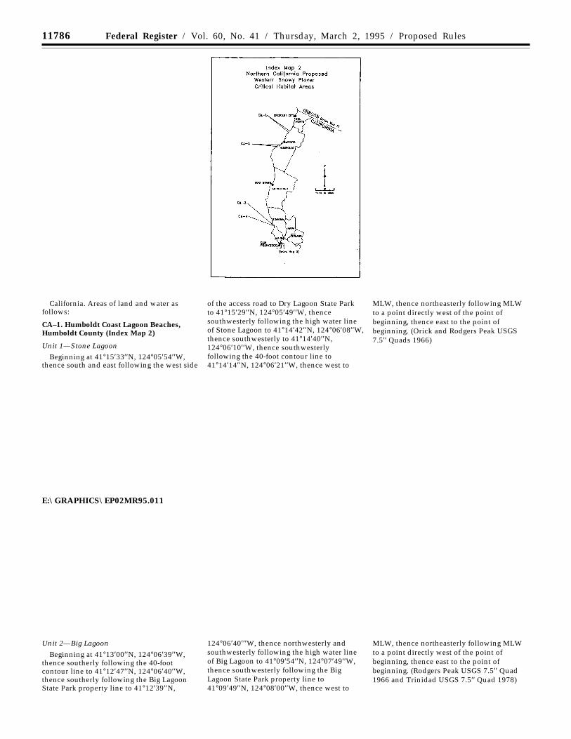
CA–1. Humboldt Coast Lagoon Beaches,Humboldt County (Index Map 2)
Unit 1—Stone LagoonBeginning at 41°15′33′′N, 124°05′54′′W,
thence south and east following the west side
of the access road to Dry Lagoon State Parkto 41°15′29′′N, 124°05′49′′W, thencesouthwesterly following the high water lineof Stone Lagoon to 41°14′42′′N, 124°06′08′′W,thence southwesterly to 41°14′40′′N,124°06′10′′W, thence southwesterlyfollowing the 40-foot contour line to41°14′14′′N, 124°06′21′′W, thence west to
MLW, thence northeasterly following MLWto a point directly west of the point ofbeginning, thence east to the point ofbeginning. (Orick and Rodgers Peak USGS7.5′′ Quads 1966)
E:\GRAPHICS\EP02MR95.011
Unit 2—Big Lagoon
Beginning at 41°13′00′′N, 124°06′39′′W,thence southerly following the 40-footcontour line to 41°12′47′′N, 124°06′40′′W,thence southerly following the Big LagoonState Park property line to 41°12′39′′N,
124°06′40′′′W, thence northwesterly andsouthwesterly following the high water lineof Big Lagoon to 41°09′54′′N, 124°07′49′′W,thence southwesterly following the BigLagoon State Park property line to41°09′49′′N, 124°08′00′′W, thence west to
MLW, thence northeasterly following MLWto a point directly west of the point ofbeginning, thence east to the point ofbeginning. (Rodgers Peak USGS 7.5′′ Quad1966 and Trinidad USGS 7.5′′ Quad 1978)
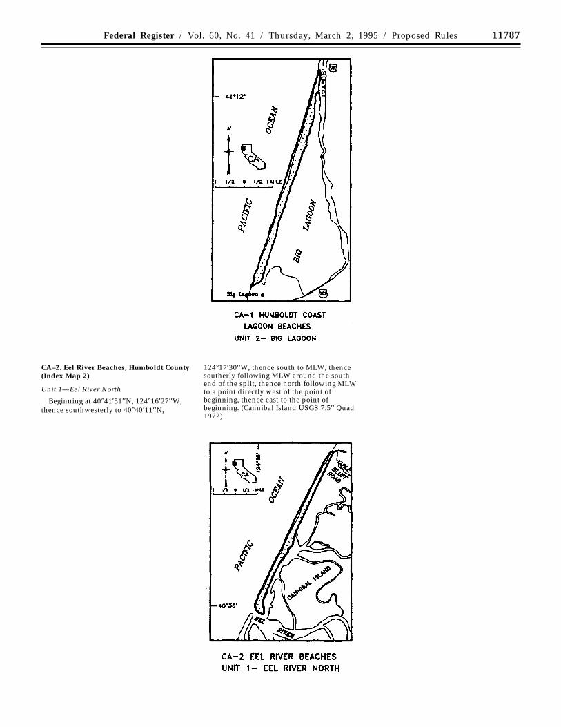
11787Federal Register / Vol. 60, No. 41 / Thursday, March 2, 1995 / Proposed Rules
CA–2. Eel River Beaches, Humboldt County(Index Map 2)
Unit 1—Eel River North
Beginning at 40°41′51′′N, 124°16′27′′W,thence southwesterly to 40°40′11′′N,
124°17′30′′W, thence south to MLW, thencesoutherly following MLW around the southend of the split, thence north following MLWto a point directly west of the point ofbeginning, thence east to the point ofbeginning. (Cannibal Island USGS 7.5′′ Quad1972)

11788 Federal Register / Vol. 60, No. 41 / Thursday, March 2, 1995 / Proposed Rules
Unit 2—Eel River South
Beginning at 40°34′29′′N, 124°21′01′′W,thence west to MLW, thence northeasterlyfollowing MLW to a point directly west of40°38′28′′N, 124°18′42′′W, thence east to said
point, thence east to MHW of the left bankof the Eel and Salt Rivers, thencesouthwesterly following MHW of the leftbank of the Salt River to 40°37′54′′N,124°18′52′′W, thence southerly to40°37′38′′N, 124°18′53′′W, thence
southwesterly to 40°37′14′′N, 124°19′25′′W,thence southwesterly to 40°36′44′′N,124°19′36′′W, thence southwesterly to40°34′29′′N, 124°20′56′′W, thence westerly tothe point of beginning. (Cannibal Island andFerndale USGS 7.5′′ Quads 1972)
CA–3. Bodega Bay, Sonoma County (IndexMap 2)
Unit 1—Bodega HarborBeginning at 38°18′51′′N, 123°03′02′′W, at
MHW on Doran Spit, thence north to38°19′30′′N, 123°03′02′′W, thence east to38°19′30′′N, 123°02′38′′W, thencesoutheasterly to 38°19′22′′N, 123°02′26′′W,thence southerly to 38°19′13′′N,
123°02′20′′W, on the MHW line of BodegaHarbor, thence southerly and westerlyfollowing MHW to the point of beginning.(Bodega Head USGS 7.5′′ Quad 1972)
Unit 2—Doran Beach
Beginning at 38°18′22′′ N, 123°03′09′′W, atthe west end of the North Jetty, thence eastto MLW, thence northerly and easterlyfollowing MLW to a point directly south of
38°18′44′′N, 123°01′36′′W, thence north tosaid point, thence northwesterly to38°18′52′′N, 123°02′07′′W, thence westerly to38°18′51′′N, 123°02′34′′W, thencesouthwesterly to 38°18′42′′N, 123°03′01′′W,thence southwesterly to 38°18′34′′N,123°03′08′′W, thence southerly to the pointof beginning. (Bodega Head USGS 7.5′′ Quad1972)
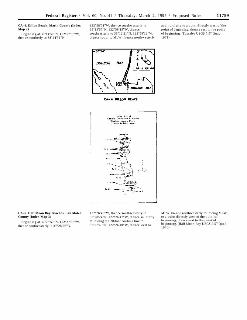
11789Federal Register / Vol. 60, No. 41 / Thursday, March 2, 1995 / Proposed Rules
CA–4. Dillon Beach, Marin County (IndexMap 2)
Beginning at 38°14′57′′N, 122°57′58′′W,thence southerly to 38°14′31′′N,
122°58′01′′W, thence southwesterly to38°13′57′′N, 122°58′15′′W, thencesoutheasterly to 38°13′21′′N, 122°58′12′′W,thence south to MLW, thence northwesterly
and northerly to a point directly west of thepoint of beginning, thence east to the pointof beginning. (Tomales USGS 7.5′′ Quad1971)
CA–5. Half Moon Bay Beaches, San MateoCounty (Index Map 3)
Beginning at 37°28′57′′N, 122°27′06′′W,thence southeasterly to 37°28′26′′N,
122°26′45′′W, thence southwesterly to37°28′24′′N, 122°26′47′′W, thence southerlyfollowing the 20-foot contour line to37°27′49′′N, 122°26′40′′W, thence west to
MLW, thence northwesterly following MLWto a point directly west of the point ofbeginning, thence east to the point ofbeginning. (Half Moon Bay USGS 7.5′′ Quad1973)
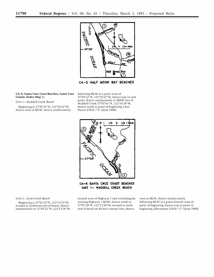
11790 Federal Register / Vol. 60, No. 41 / Thursday, March 2, 1995 / Proposed Rules
CA–6. Santa Cruz Coast Beaches, Santa CruzCounty (Index Map 3)
Unit 1—Waddell Creek Beach
Beginning at 37°05′35′′N, 122°16′32′′W,thence west to MLW, thence northwesterly
following MLW to a point west of37°05′52′′N, 122°16′32′′W, thence east to saidpoint, thence southeasterly to MHW line ofWaddell Creek 37°05′41′′N, 122°16′34′′W,thence south to point of beginning. (AnoNuevo USGS 7.5′′ Quad 1968)
Unit 2—Scott Creek BeachBeginning at 37°02′33′′N, 122°13′53′′W,
located at northwest end of beach, thencesoutheasterly to 37°02′22′′N, 122°13′36′′W,
located west of Highway 1 and excluding theexisting Highway 1 ROW, thence south to37°01′58′′N, 122°13′34′′W, located at southend of beach on 60 foot contour line, thence
west to MLW, thence northwesterlyfollowing MLW to a point directly west ofpoint of beginning, thence east to point ofbeginning. (Davenport USGS 7.5′′ Quad 1968)

11791Federal Register / Vol. 60, No. 41 / Thursday, March 2, 1995 / Proposed Rules
Unit 3—Laguna Creek Beach
Beginning at 36°59′04′′N, 122°09′26′′W,located at northwest end of beach on 20 foot
contour line, thence east following 20 footcontour line to 36°59′03′′N, 122°09′14′′W,located at Laguna Creek at a point 800 feetsouth of Highway 1, thence south to MLW,
thence northwesterly following MLW to apoint directly south of point of beginning,thence north to point of beginning. (SantaCruz USGS 7.5′′ Quad 1981)
Unit 4—Wilder Creek BeachBeginning at 36°57′17′′N, 122°04′43′′W,
located at northwest end of upper beach on40 foot contour line, thence southwesterly to
36°57′16′′N, 122°04′29′′W, located atnortheast end of upper beach east of 40 footcontour line, thence south to MLW, thencenorthwesterly following MLW to 40 foot
contour line at west end of beach, thencenorth following 40 foot contour line to pointof beginning. (Santa Cruz USGS 7.5′′ Quad1981)
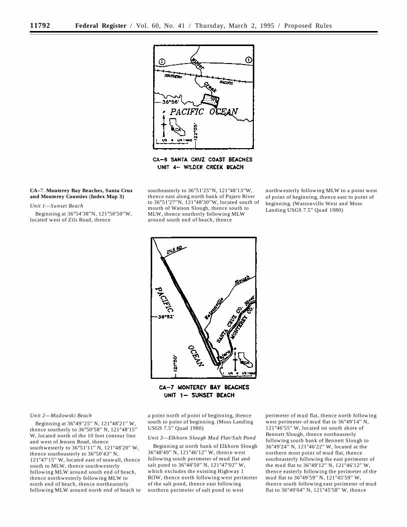
11792 Federal Register / Vol. 60, No. 41 / Thursday, March 2, 1995 / Proposed Rules
CA–7. Monterey Bay Beaches, Santa Cruzand Monterey Counties (Index Map 3)
Unit 1—Sunset Beach
Beginning at 36°54′38′′N, 121°50′50′′W,located west of Zils Road, thence
southeasterly to 36°51′25′′N, 121°48′13′′W,thence east along north bank of Pajaro Riverto 36°51′27′′N, 121°48′30′′W, located south ofmouth of Watson Slough, thence south toMLW, thence southerly following MLWaround south end of beach, thence
northwesterly following MLW to a point westof point of beginning, thence east to point ofbeginning. (Watsonville West and MossLanding USGS 7.5′′ Quad 1980)
Unit 2—Mudowski Beach
Beginning at 36°49′′25′′ N, 121°48′21′′ W,thence southerly to 36°50′58′′ N, 121°48′15′′W, located north of the 10 foot contour lineand west of Jensen Road, thencesouthwesterly to 36°51′11′′ N, 121°48′20′′ W,thence southeasterly to 36°50′43′′ N,121°47′15′′ W, located east of seawall, thencesouth to MLW, thence southwesterlyfollowing MLW around south end of beach,thence northwesterly following MLW tonorth end of beach, thence northeasterlyfollowing MLW around north end of beach to
a point north of point of beginning, thencesouth to point of beginning. (Moss LandingUSGS 7.5′′ Quad 1980)
Unit 3—Elkhorn Slough Mud Flat/Salt Pond
Beginning at north bank of Elkhorn Slough36°48′49′′ N, 121°46′12′′ W, thence westfollowing south perimeter of mud flat andsalt pond to 36°48′50′′ N, 121°47′02′′ W,which excludes the existing Highway 1ROW, thence north following west perimeterof the salt pond, thence east followingnorthern perimeter of salt pond to west
perimeter of mud flat, thence north followingwest perimeter of mud flat to 36°49′14′′ N,121°46′55′′ W, located on south shore ofBennett Slough, thence northeasterlyfollowing south bank of Bennett Slough to36°49′24′′ N, 121°46′22′′ W, located at thenorthern most point of mud flat, thencesoutheasterly following the east perimeter ofthe mud flat to 36°49′12′′ N, 121°46′12′′ W,thence easterly following the perimeter of themud flat to 36°49′59′′ N, 121°45′59′′ W,thence south following east perimeter of mudflat to 36°49′04′′ N, 121°45′58′′ W, thence
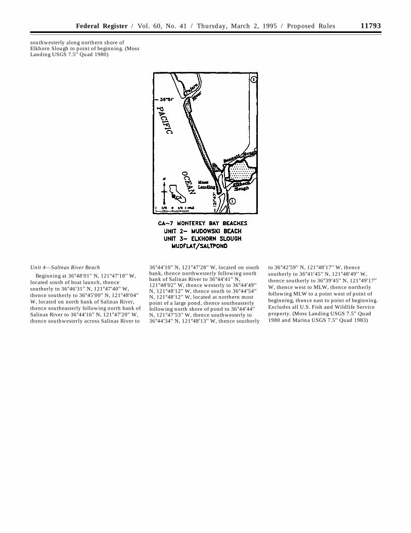
11793Federal Register / Vol. 60, No. 41 / Thursday, March 2, 1995 / Proposed Rules
southwesterly along northern shore ofElkhorn Slough to point of beginning. (MossLanding USGS 7.5′′ Quad 1980)
Unit 4—Salinas River Beach
Beginning at 36°48′01′′ N, 121°47′18′′ W,located south of boat launch, thencesoutherly to 36°46′31′′ N, 121°47′40′′ W,thence southerly to 36°45′00′′ N, 121°48′04′′W, located on north bank of Salinas River,thence southeasterly following north bank ofSalinas River to 36°44′16′′ N, 121°47′20′′ W,thence southwesterly across Salinas River to
36°44′10′′ N, 121°47′28′′ W, located on southbank, thence northwesterly following southbank of Salinas River to 36°44′41′′ N,121°48′02′′ W, thence westerly to 36°44′49′′N, 121°48′12′′ W, thence south to 36°44′54′′N, 121°48′12′′ W, located at northern mostpoint of a large pond, thence southeasterlyfollowing north shore of pond to 36°44′44′′N, 121°47′53′′ W, thence southwesterly to36°44′34′′ N, 121°48′13′′ W, thence southerly
to 36°42′59′′ N, 121°48′17′′ W, thencesoutherly to 36°41′45′′ N, 121°48′49′′ W,thence southerly to 36°39′45′′ N, 121°49′17′′W, thence west to MLW, thence northerlyfollowing MLW to a point west of point ofbeginning, thence east to point of beginning.Excludes all U.S. Fish and Wildlife Serviceproperty. (Moss Landing USGS 7.5′′ Quad1980 and Marina USGS 7.5′′ Quad 1983)
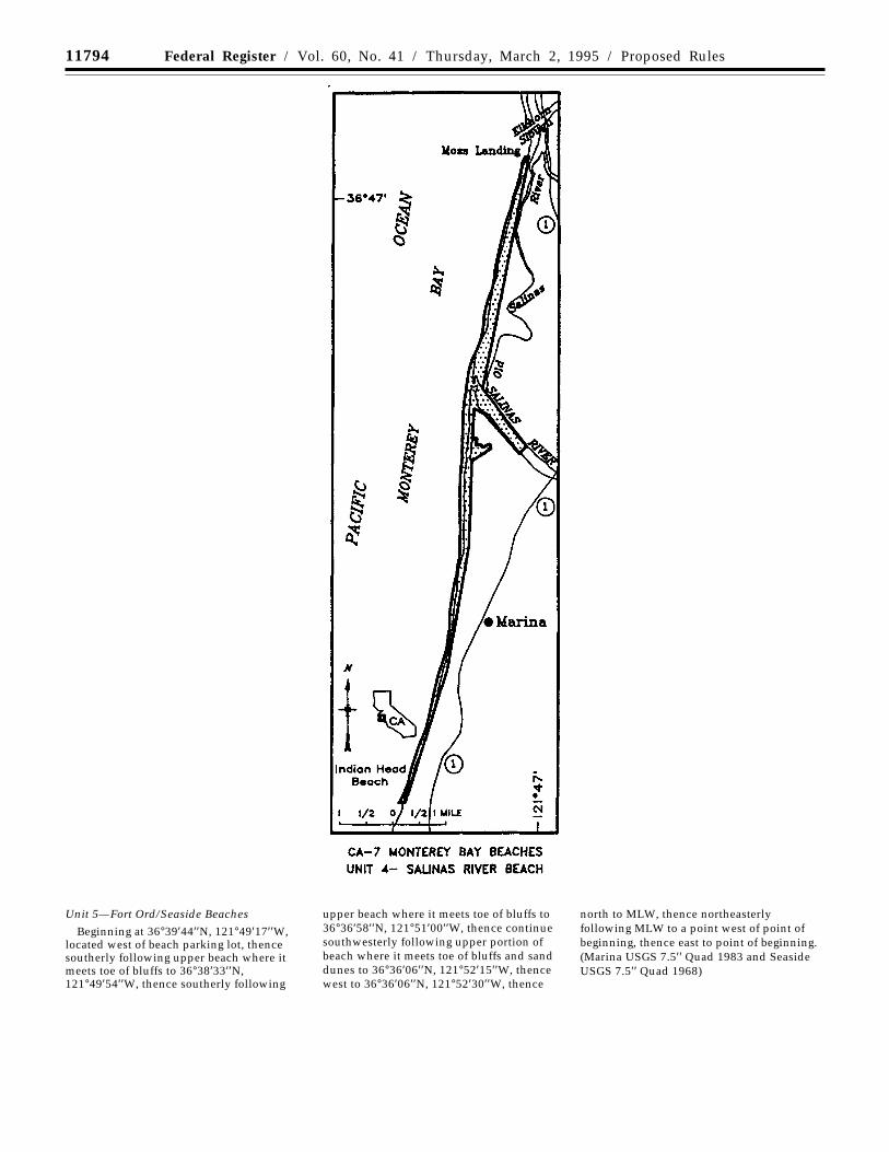
11794 Federal Register / Vol. 60, No. 41 / Thursday, March 2, 1995 / Proposed Rules
Unit 5—Fort Ord/Seaside Beaches
Beginning at 36°39′44′′N, 121°49′17′′W,located west of beach parking lot, thencesoutherly following upper beach where itmeets toe of bluffs to 36°38′33′′N,121°49′54′′W, thence southerly following
upper beach where it meets toe of bluffs to36°36′58′′N, 121°51′00′′W, thence continuesouthwesterly following upper portion ofbeach where it meets toe of bluffs and sanddunes to 36°36′06′′N, 121°52′15′′W, thencewest to 36°36′06′′N, 121°52′30′′W, thence
north to MLW, thence northeasterlyfollowing MLW to a point west of point ofbeginning, thence east to point of beginning.(Marina USGS 7.5′′ Quad 1983 and SeasideUSGS 7.5′′ Quad 1968)
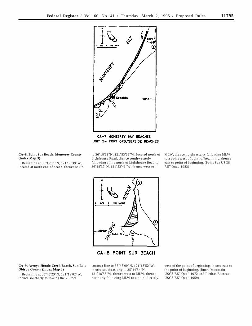
11795Federal Register / Vol. 60, No. 41 / Thursday, March 2, 1995 / Proposed Rules
CA–8. Point Sur Beach, Monterey County(Index Map 3)
Beginning at 36°19′11′′N, 121°53′39′′W,located at north end of beach, thence south
to 36°18′31′′N, 121°53′32′′W, located north ofLighthouse Road, thence southwesterlyfollowing a line north of Lighthouse Road to36°18′37′′N, 121°53′46′′W, thence west to
MLW, thence northeasterly following MLWto a point west of point of beginning, thenceeast to point of beginning. (Point Sur USGS7.5′′ Quad 1983)
CA–9. Arroyo Hondo Creek Beach, San LuisObispo County (Index Map 3)
Beginning at 35°45′23′′N, 121°19′02′′W,thence southerly following the 20-foot
contour line to 35°45′00′′N, 121°18′52′′W,thence southeasterly to 35°44′54′′N,121°18′55′′W, thence west to MLW, thencenortherly following MLW to a point directly
west of the point of beginning, thence east tothe point of beginning. (Burro MountainUSGS 7.5′′ Quad 1972 and Piedras BlancasUSGS 7.5′′ Quad 1959)
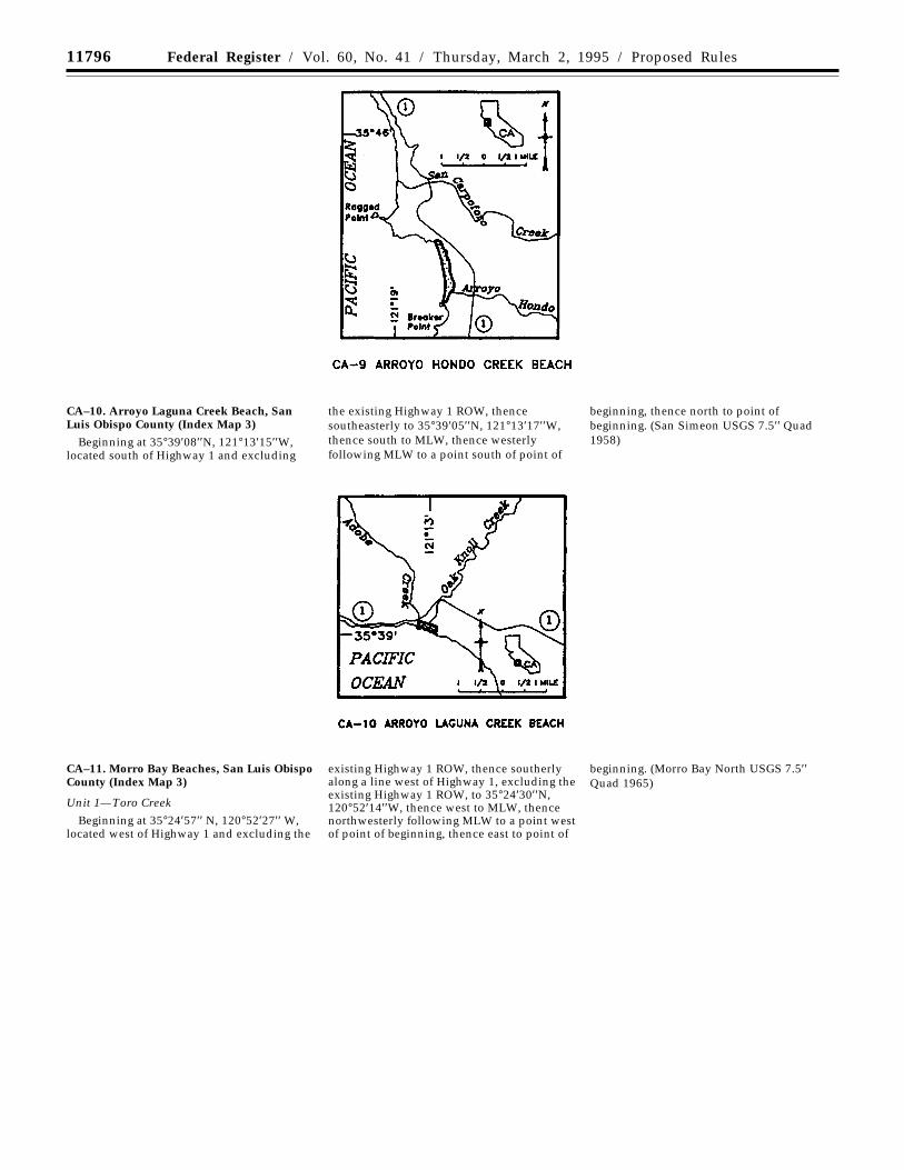
11796 Federal Register / Vol. 60, No. 41 / Thursday, March 2, 1995 / Proposed Rules
CA–10. Arroyo Laguna Creek Beach, SanLuis Obispo County (Index Map 3)
Beginning at 35°39′08′′N, 121°13′15′′W,located south of Highway 1 and excluding
the existing Highway 1 ROW, thencesoutheasterly to 35°39′05′′N, 121°13′17′′W,thence south to MLW, thence westerlyfollowing MLW to a point south of point of
beginning, thence north to point ofbeginning. (San Simeon USGS 7.5′′ Quad1958)
CA–11. Morro Bay Beaches, San Luis ObispoCounty (Index Map 3)
Unit 1—Toro Creek
Beginning at 35°24′57′′ N, 120°52′27′′ W,located west of Highway 1 and excluding the
existing Highway 1 ROW, thence southerlyalong a line west of Highway 1, excluding theexisting Highway 1 ROW, to 35°24′30′′N,120°52′14′′W, thence west to MLW, thencenorthwesterly following MLW to a point westof point of beginning, thence east to point of
beginning. (Morro Bay North USGS 7.5′′Quad 1965)
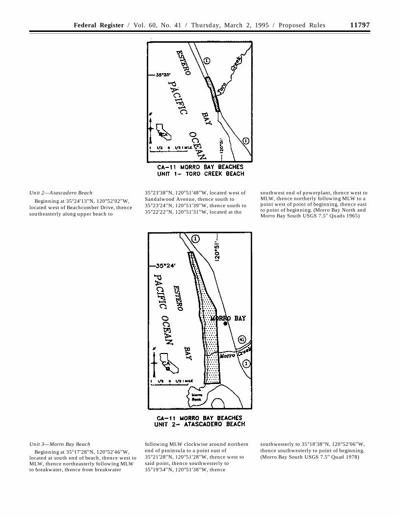
11797Federal Register / Vol. 60, No. 41 / Thursday, March 2, 1995 / Proposed Rules
Unit 2—Atascadero Beach
Beginning at 35°24′13′′N, 120°52′02′′W,located west of Beachcomber Drive, thencesoutheasterly along upper beach to
35°23′38′′N, 120°51′48′′W, located west ofSandalwood Avenue, thence south to35°23′24′′N, 120°51′39′′W, thence south to35°22′22′′N, 120°51′31′′W, located at the
southwest end of powerplant, thence west toMLW, thence northerly following MLW to apoint west of point of beginning, thence eastto point of beginning. (Morro Bay North andMorro Bay South USGS 7.5′′ Quads 1965)
Unit 3—Morro Bay Beach
Beginning at 35°17′28′′N, 120°52′46′′W,located at south end of beach, thence west toMLW, thence northeasterly following MLWto breakwater, thence from breakwater
following MLW clockwise around northernend of peninsula to a point east of35°21′28′′N, 120°51′28′′W, thence west tosaid point, thence southwesterly to35°19′54′′N, 120°51′38′′W, thence
southwesterly to 35°18′38′′N, 120°52′06′′W,thence southwesterly to point of beginning.(Morro Bay South USGS 7.5′′ Quad 1978)
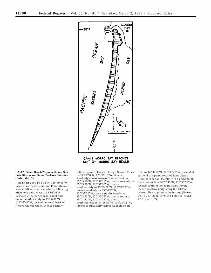
11798 Federal Register / Vol. 60, No. 41 / Thursday, March 2, 1995 / Proposed Rules
CA–12. Pismo Beach/Nipomo Dunes, SanLuis Obispo and Santa Barbara Counties(Index Map 3)
Beginning at 34°53′02′′N, 120°39′40′′W,located northeast of Mussel Point, thencewest to MLW, thence northerly followingMLW to a point west of 35°06′06′′N,120°37′45′′W, thence east to said point,thence southeasterly to 35°06′01′′N,120°37′40′′W, located on north bank ofArroyo Grande Creek, thence easterly
following north bank of Arroyo Grande Creekto 35°05′58′′N, 120°37′19′′W, thencesoutherly across Arroyo Grande Creek to35°05′56′′N, 120°37′18′′W, thence westerly to35°05′58′′N, 120°37′38′′W, thencesoutheasterly to 35°05′27′′N, 120°37′32′′W,thence southerly to 35°04′27′′N,120°37′30′′W, thence southwesterly to35°02′32′′N, 120°37′35′′W, thence south to35°01′42′′N, 120°37′35′′W, thencesouthwesterly to 34°58′53′′N, 120°39′02′′W,thence southeasterly across Guadalupe oil
field to 34°58′10′′N, 120°38′27′′W, located ateast end of a pond north of Santa MariaRiver, thence southwesterly to a point on 40-foot contour line 34°57′45′′N, 120°38′59′′W,located south of the Santa Maria River,thence southwesterly along the 40-footcontour line to point of beginning. (OceanoUSGS 7.5′′ Quad 1979 and Point Sal USGS7.5′′ Quad 1974)
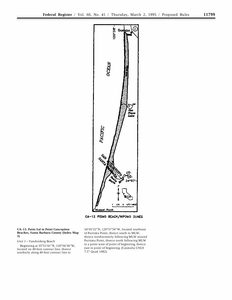
11799Federal Register / Vol. 60, No. 41 / Thursday, March 2, 1995 / Proposed Rules
CA–13. Point Sal to Point ConceptionBeaches, Santa Barbara County (Index Map3)
Unit 1—Vandenberg BeachBeginning at 35°51′41′′N, 120°36′36′′W,
located on 40-foot contour line, thencesoutherly along 40-foot contour line to
34°45′22′′N, 120°37′50′′W, located southeastof Purisma Point, thence south to MLW,thence northwesterly following MLW aroundPurisma Point, thence north following MLWto a point west of point of beginning, thenceeast to point of beginning. (Casmalia USGS7.5′′ Quad 1982)
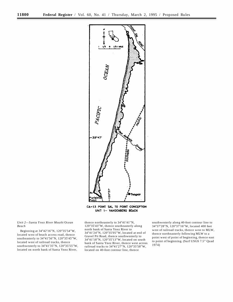
11800 Federal Register / Vol. 60, No. 41 / Thursday, March 2, 1995 / Proposed Rules
Unit 2—Santa Ynez River Mouth/OceanBeach
Beginning at 34°42′16′′N, 120°35′54′′W,located west of beach access road, thencesoutheasterly to 34°41′56′′N, 120°35′45′′W,located west of railroad tracks, thencesouthwesterly to 34°41′35′′N, 120°35′55′′W,located on north bank of Santa Ynez River,
thence northeasterly to 34°41′41′′N,120°35′43′′W, thence southeasterly alongnorth bank of Santa Ynez River to34°41′24′′N, 120°35′05′′W, located at end ofGravel Pit Road, thence southwesterly to34°41′18′′N, 120°35′13′′W, located on southbank of Santa Ynez River, thence west acrossrailroad tracks to 34°41′27′′N, 120°35′58′′W,located on 40-foot contour line, thence
southwesterly along 40-foot contour line to34°37′28′′N, 120°37′16′′W, located 400 feetwest of railroad tracks, thence west to MLW,thence northeasterly following MLW to apoint west of point of beginning, thence eastto point of beginning. (Surf USGS 7.5′′ Quad1974)
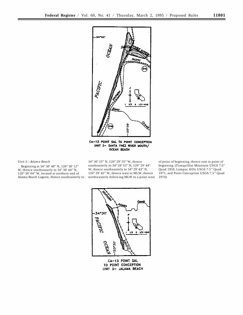
11801Federal Register / Vol. 60, No. 41 / Thursday, March 2, 1995 / Proposed Rules
Unit 3—Jalama Beach
Beginning at 34° 30′ 48′′ N, 120° 30′ 12′′W, thence southeasterly to 34° 30′ 44′′ N,120° 30′ 04′′ W, located at northern end ofJalama Beach Lagoon, thence southeasterly to
34° 30′ 23′′ N, 120° 29′ 55′′ W, thencesoutheasterly to 34° 29′ 53′′ N, 120° 29′ 44′′W, thence southeasterly to 34° 29′ 43′′ N,120° 29′ 42′′ W, thence west to MLW, thencenorthwesterly following MLW to a point west
of point of beginning, thence east to point ofbeginning. (Tranquillon Mountain USGS 7.5′′Quad 1959, Lompoc Hills USGS 7.5’’ Quad1971, and Point Conception USGS 7.5’’ Quad1974)
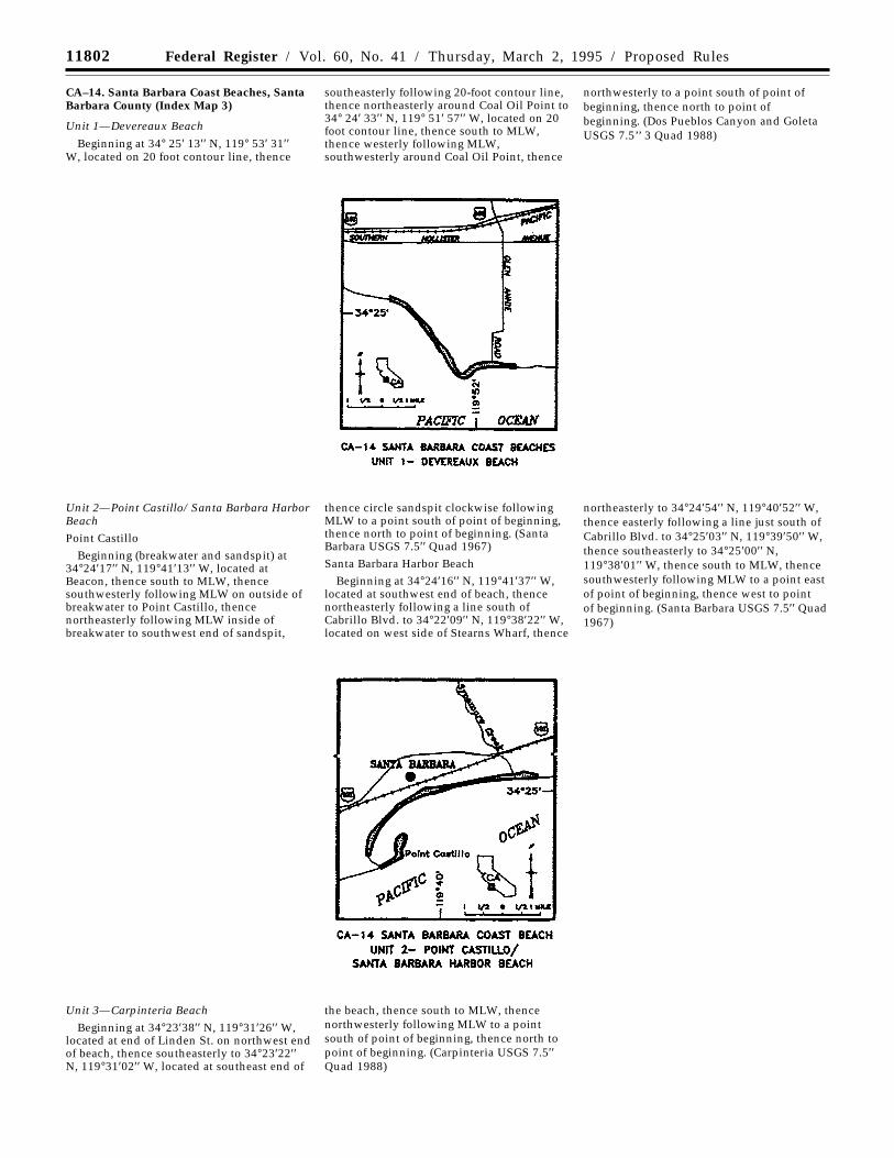
11802 Federal Register / Vol. 60, No. 41 / Thursday, March 2, 1995 / Proposed Rules
CA–14. Santa Barbara Coast Beaches, SantaBarbara County (Index Map 3)
Unit 1—Devereaux Beach
Beginning at 34° 25′ 13′′ N, 119° 53′ 31′′W, located on 20 foot contour line, thence
southeasterly following 20-foot contour line,thence northeasterly around Coal Oil Point to34° 24′ 33′′ N, 119° 51′ 57′′ W, located on 20foot contour line, thence south to MLW,thence westerly following MLW,southwesterly around Coal Oil Point, thence
northwesterly to a point south of point ofbeginning, thence north to point ofbeginning. (Dos Pueblos Canyon and GoletaUSGS 7.5’’ 3 Quad 1988)
Unit 2—Point Castillo/ Santa Barbara HarborBeachPoint Castillo
Beginning (breakwater and sandspit) at34°24′17′′ N, 119°41′13′′ W, located atBeacon, thence south to MLW, thencesouthwesterly following MLW on outside ofbreakwater to Point Castillo, thencenortheasterly following MLW inside ofbreakwater to southwest end of sandspit,
thence circle sandspit clockwise followingMLW to a point south of point of beginning,thence north to point of beginning. (SantaBarbara USGS 7.5′′ Quad 1967)
Santa Barbara Harbor Beach
Beginning at 34°24′16′′ N, 119°41′37′′ W,located at southwest end of beach, thencenortheasterly following a line south ofCabrillo Blvd. to 34°22′09′′ N, 119°38′22′′ W,located on west side of Stearns Wharf, thence
northeasterly to 34°24′54′′ N, 119°40′52′′ W,thence easterly following a line just south ofCabrillo Blvd. to 34°25′03′′ N, 119°39′50′′ W,thence southeasterly to 34°25′00′′ N,119°38′01′′ W, thence south to MLW, thencesouthwesterly following MLW to a point eastof point of beginning, thence west to pointof beginning. (Santa Barbara USGS 7.5′′ Quad1967)
Unit 3—Carpinteria BeachBeginning at 34°23′38′′ N, 119°31′26′′ W,
located at end of Linden St. on northwest endof beach, thence southeasterly to 34°23′22′′N, 119°31′02′′ W, located at southeast end of
the beach, thence south to MLW, thencenorthwesterly following MLW to a pointsouth of point of beginning, thence north topoint of beginning. (Carpinteria USGS 7.5′′Quad 1988)
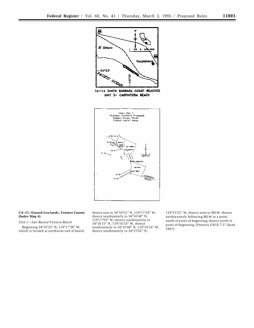
11803Federal Register / Vol. 60, No. 41 / Thursday, March 2, 1995 / Proposed Rules
CA–15. Oxnard Lowlands, Ventura County(Index Map 4)
Unit 1—San Buena/Ventura Beach
Beginning 34°16′33′′ N, 119°17′38′′ W,which is located at northwest end of beach,
thence east to 34°16′51′′ N, 119°17′24′′ W,thence southeasterly to 34°16′40′′ N,119°17′03′′ W, thence southeasterly to34°16′15′′ N, 119°16′33′′ W, thencesoutheasterly to 34°15′40′′ N, 119°16′16′′ W,thence southeasterly to 34°15′02′′ N,
119°15′52′′ W, thence west to MLW, thencenorthwesterly following MLW to a pointsouth of point of beginning, thence north topoint of beginning. (Ventura USGS 7.5′′ Quad1967)
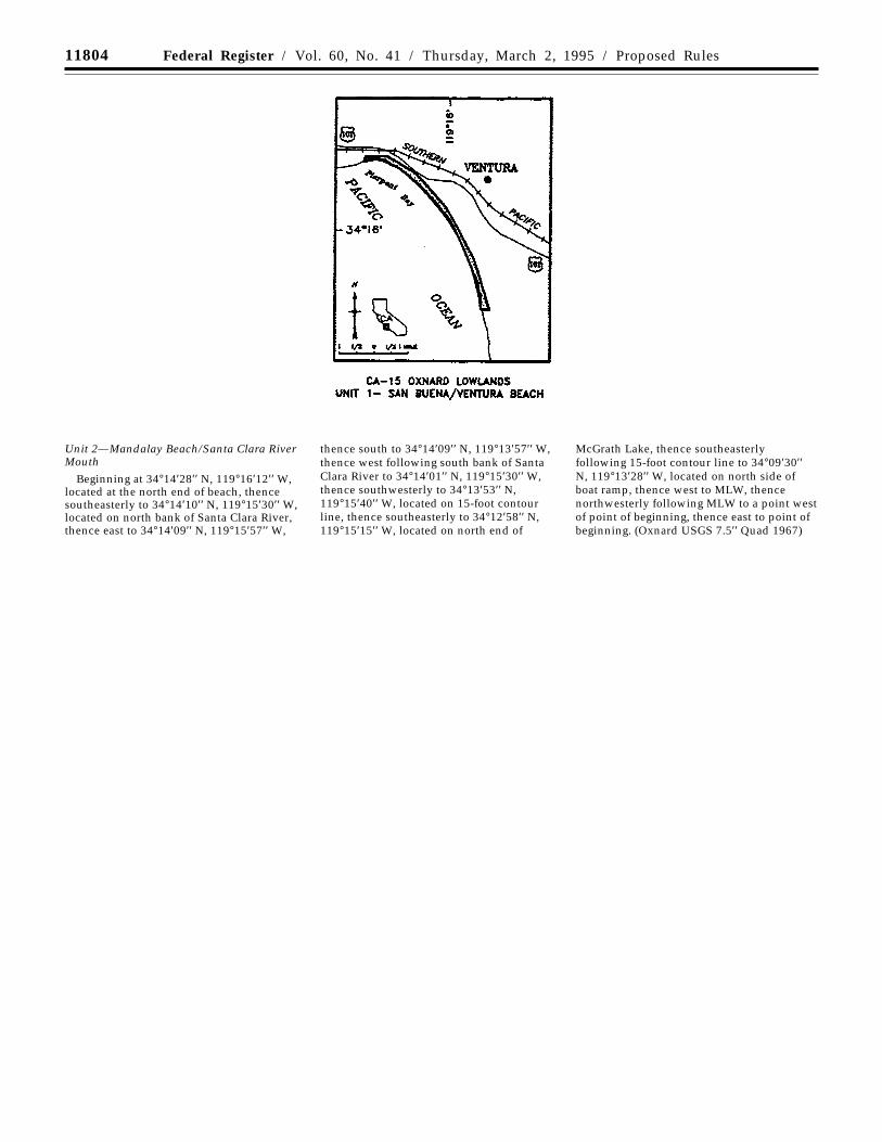
11804 Federal Register / Vol. 60, No. 41 / Thursday, March 2, 1995 / Proposed Rules
Unit 2—Mandalay Beach/Santa Clara RiverMouth
Beginning at 34°14′28′′ N, 119°16′12′′ W,located at the north end of beach, thencesoutheasterly to 34°14′10′′ N, 119°15′30′′ W,located on north bank of Santa Clara River,thence east to 34°14′09′′ N, 119°15′57′′ W,
thence south to 34°14′09′′ N, 119°13′57′′ W,thence west following south bank of SantaClara River to 34°14′01′′ N, 119°15′30′′ W,thence southwesterly to 34°13′53′′ N,119°15′40′′ W, located on 15-foot contourline, thence southeasterly to 34°12′58′′ N,119°15′15′′ W, located on north end of
McGrath Lake, thence southeasterlyfollowing 15-foot contour line to 34°09′30′′N, 119°13′28′′ W, located on north side ofboat ramp, thence west to MLW, thencenorthwesterly following MLW to a point westof point of beginning, thence east to point ofbeginning. (Oxnard USGS 7.5′′ Quad 1967)
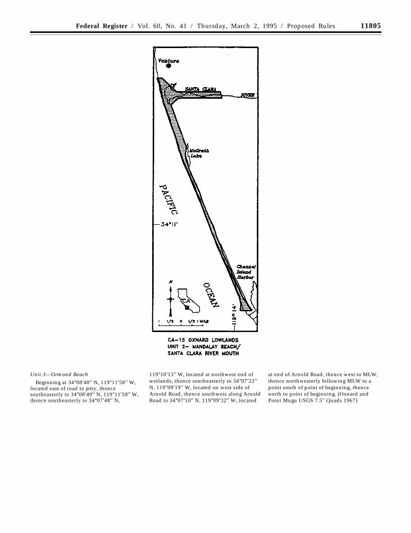
11805Federal Register / Vol. 60, No. 41 / Thursday, March 2, 1995 / Proposed Rules
Unit 3—Ormond Beach
Beginning at 34°08′40′′ N, 119°11′58′′ W,located east of road to jetty, thencesoutheasterly to 34°08′49′′ N, 119°11′58′′ W,thence southeasterly to 34°07′48′′ N,
119°10′15′′ W, located at northwest end ofwetlands, thence southeasterly to 34°07′22′′N, 119°09′19′′ W, located on west side ofArnold Road, thence southwest along ArnoldRoad to 34°07′10′′ N, 119°09′32′′ W, located
at end of Arnold Road, thence west to MLW,thence northwesterly following MLW to apoint south of point of beginning, thencenorth to point of beginning. (Oxnard andPoint Mugu USGS 7.5′′ Quads 1967)
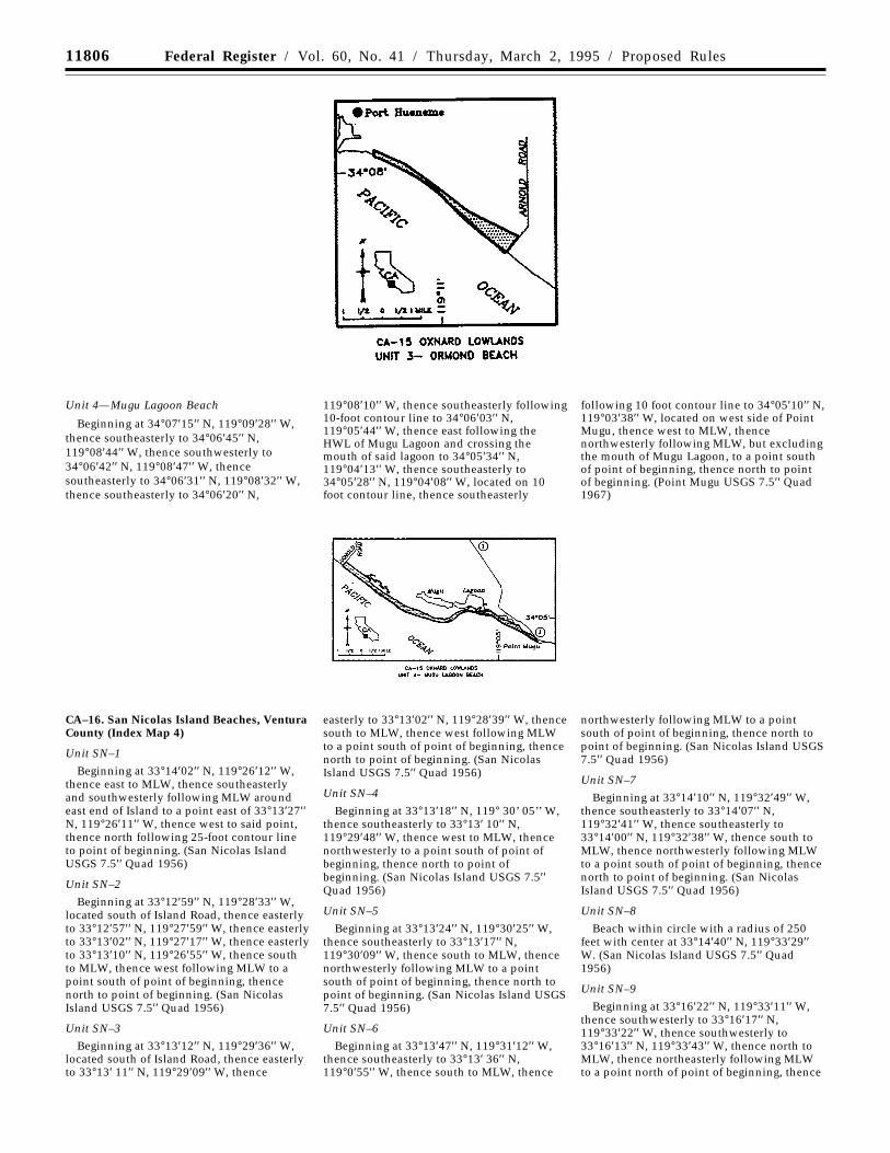
11806 Federal Register / Vol. 60, No. 41 / Thursday, March 2, 1995 / Proposed Rules
Unit 4—Mugu Lagoon Beach
Beginning at 34°07′15′′ N, 119°09′28′′ W,thence southeasterly to 34°06′45′′ N,119°08′44′′ W, thence southwesterly to34°06′42′′ N, 119°08′47′′ W, thencesoutheasterly to 34°06′31′′ N, 119°08′32′′ W,thence southeasterly to 34°06′20′′ N,
119°08′10′′ W, thence southeasterly following10-foot contour line to 34°06′03′′ N,119°05′44′′ W, thence east following theHWL of Mugu Lagoon and crossing themouth of said lagoon to 34°05′34′′ N,119°04′13′′ W, thence southeasterly to34°05′28′′ N, 119°04′08′′ W, located on 10foot contour line, thence southeasterly
following 10 foot contour line to 34°05′10′′ N,119°03′38′′ W, located on west side of PointMugu, thence west to MLW, thencenorthwesterly following MLW, but excludingthe mouth of Mugu Lagoon, to a point southof point of beginning, thence north to pointof beginning. (Point Mugu USGS 7.5′′ Quad1967)
CA–16. San Nicolas Island Beaches, VenturaCounty (Index Map 4)
Unit SN–1
Beginning at 33°14′02′′ N, 119°26′12′′ W,thence east to MLW, thence southeasterlyand southwesterly following MLW aroundeast end of Island to a point east of 33°13′27′′N, 119°26′11′′ W, thence west to said point,thence north following 25-foot contour lineto point of beginning. (San Nicolas IslandUSGS 7.5′′ Quad 1956)
Unit SN–2
Beginning at 33°12′59′′ N, 119°28′33′′ W,located south of Island Road, thence easterlyto 33°12′57′′ N, 119°27′59′′ W, thence easterlyto 33°13′02′′ N, 119°27′17′′ W, thence easterlyto 33°13′10′′ N, 119°26′55′′ W, thence southto MLW, thence west following MLW to apoint south of point of beginning, thencenorth to point of beginning. (San NicolasIsland USGS 7.5′′ Quad 1956)
Unit SN–3
Beginning at 33°13′12′′ N, 119°29′36′′ W,located south of Island Road, thence easterlyto 33°13′ 11′′ N, 119°29′09′′ W, thence
easterly to 33°13′02′′ N, 119°28′39′′ W, thencesouth to MLW, thence west following MLWto a point south of point of beginning, thencenorth to point of beginning. (San NicolasIsland USGS 7.5′′ Quad 1956)
Unit SN–4
Beginning at 33°13′18′′ N, 119° 30’ 05’’ W,thence southeasterly to 33°13′ 10′′ N,119°29′48′′ W, thence west to MLW, thencenorthwesterly to a point south of point ofbeginning, thence north to point ofbeginning. (San Nicolas Island USGS 7.5′′Quad 1956)
Unit SN–5
Beginning at 33°13′24′′ N, 119°30′25′′ W,thence southeasterly to 33°13′17′′ N,119°30′09′′ W, thence south to MLW, thencenorthwesterly following MLW to a pointsouth of point of beginning, thence north topoint of beginning. (San Nicolas Island USGS7.5′′ Quad 1956)
Unit SN–6
Beginning at 33°13′47′′ N, 119°31′12′′ W,thence southeasterly to 33°13′ 36′′ N,119°0′55′′ W, thence south to MLW, thence
northwesterly following MLW to a pointsouth of point of beginning, thence north topoint of beginning. (San Nicolas Island USGS7.5′′ Quad 1956)
Unit SN–7
Beginning at 33°14′10′′ N, 119°32′49′′ W,thence southeasterly to 33°14′07′′ N,119°32′41′′ W, thence southeasterly to33°14′00′′ N, 119°32′38′′ W, thence south toMLW, thence northwesterly following MLWto a point south of point of beginning, thencenorth to point of beginning. (San NicolasIsland USGS 7.5′′ Quad 1956)
Unit SN–8
Beach within circle with a radius of 250feet with center at 33°14′40′′ N, 119°33′29′′W. (San Nicolas Island USGS 7.5′′ Quad1956)
Unit SN–9
Beginning at 33°16′22′′ N, 119°33′11′′ W,thence southwesterly to 33°16′17′′ N,119°33′22′′ W, thence southwesterly to33°16′13′′ N, 119°33′43′′ W, thence north toMLW, thence northeasterly following MLWto a point north of point of beginning, thence

11807Federal Register / Vol. 60, No. 41 / Thursday, March 2, 1995 / Proposed Rules
south to point of beginning. (San NicolasIsland USGS 7.5′′ Quad 1956)
Unit SN–10Beginning at 33°17′01′′ N, 119°31′58′′ W,
thence southwesterly to 33°16′51′′ N,119°32′08′′ W, thence southwesterly to33°16′47′′ N, 119°32′21′′ W, thence north toMLW, thence northeasterly following MLWto a point west of point of beginning, thenceeast to point of beginning. (San NicolasIsland USGS 7.5′′ Quad 1956)
Unit SN–11
Beginning at 33°15′31′′ N, 119°27′52′′ W,thence westerly to 33°15′32′′ N, 119°28′11′′W, thence westerly to 33°15′46′′ N,119°28′55′′ W, thence northwesterly to33°15′59′′ N, 119°29′10′′ W, thencesouthwesterly to 33°15′54′′ N, 119°29′34′′ W,thence northwesterly to 33°15′58′′ N,119°29′52′′ W, thence north to MLW, thenceeasterly following MLW to a point north ofpoint of beginning, thence south to point of
beginning. (San Nicolas Island USGS 7.5′′Quad 1956)
Unit SN–12
Beginning at 33°14′25′′ N, 119°26′35′′ W,thence northwesterly to 33°14′40′′ N,119°26′49′′ W, thence east to MLW, thencesoutheasterly following MLW to a point eastof point of beginning, thence west to pointof beginning. (San Nicolas Island USGS 7.5′′Quad 1956)
CA–17. Malibu Lagoon, Los Angeles County(Index Map 4)
Beginning at 34°01′58′′ N, 118°40′53′′ W,thence northwesterly crossing Highway 1,and excluding Highway 1 and the existingROW north and south of Highway 1, to
34°02′04′′ N, 118°40′56′′ W, thencenorthwesterly to 34°02′13′′ N, 118°40′59′′ W,thence northeasterly to 34°02′14′′ N,118°40′56′′ W, thence southeasterly to34°02′03′′ N, 118°40′47′′ W, thence east to34°02′03′′ N, 118°40′44′′ W, thence
northeasterly to 34°02′12′′ N, 118°40′37′′ W,thence south to MLW, thence southerly andwesterly following MLW to a point directlysouth of the point of beginning, thence northto the point of beginning. (Malibu BeachUSGS 7.5′′ Quad 1981)
CA–18. Mission Beach and Bay, San DiegoCounty (Index Map 4)
Unit 1—Fiesta Island
Beginning at 32°46′07′′ N, 117°14′34′′ W,thence south to MLW, thence southerly andnortherly following MLW to a point directlysouth of 32°45′34′′ N, 117°14′50′′ W, thencenorth to said point, thence northwesterly to32°45′52′′ N, 117°14′58′′ W, thencenortheasterly to 32°46′16′′ N, 117°14′55′′ W,thence southeasterly to the point ofbeginning. (La Jolla USGS 7.5′′ Quad 1975)
Unit 2—Mariner’s Basin
Beginning at 32°46′31′′ N, 117°13′25′′ W,thence southeasterly to 32°46′30′′ N,117°13′23′′ W, thence southwesterly to32°46′15′′ N, 117°13′34′′ W, thencesoutheasterly to 32°46′10′′ N, 117°13′23′′ W,thence south to MLW, thence westerly andnortherly following MLW to a point directlywest of the point of beginning, thence east tothe point of beginning. (La Jolla USGS 7.5′′Quad 1975)
Unit 3—Mission Beach
Beginning at 32°46′26′′ N, 117°15′08′′ W,thence southerly to 32°46′02′′ N, 117°15′06′′W, thence southerly to 32°45′43′′ N,117°15′05′′ W, thence southeasterly to32°45′34′′ N, 117°14′57′′ W, which is on thenorth jetty to Mission Bay, thence westerlyfollowing the north side of the jetty to MLW,thence northerly following MLW to a pointdirectly west of the point of beginning,thence east to the point of beginning. (LaJolla USGS 7.5′′ Quad 1975)
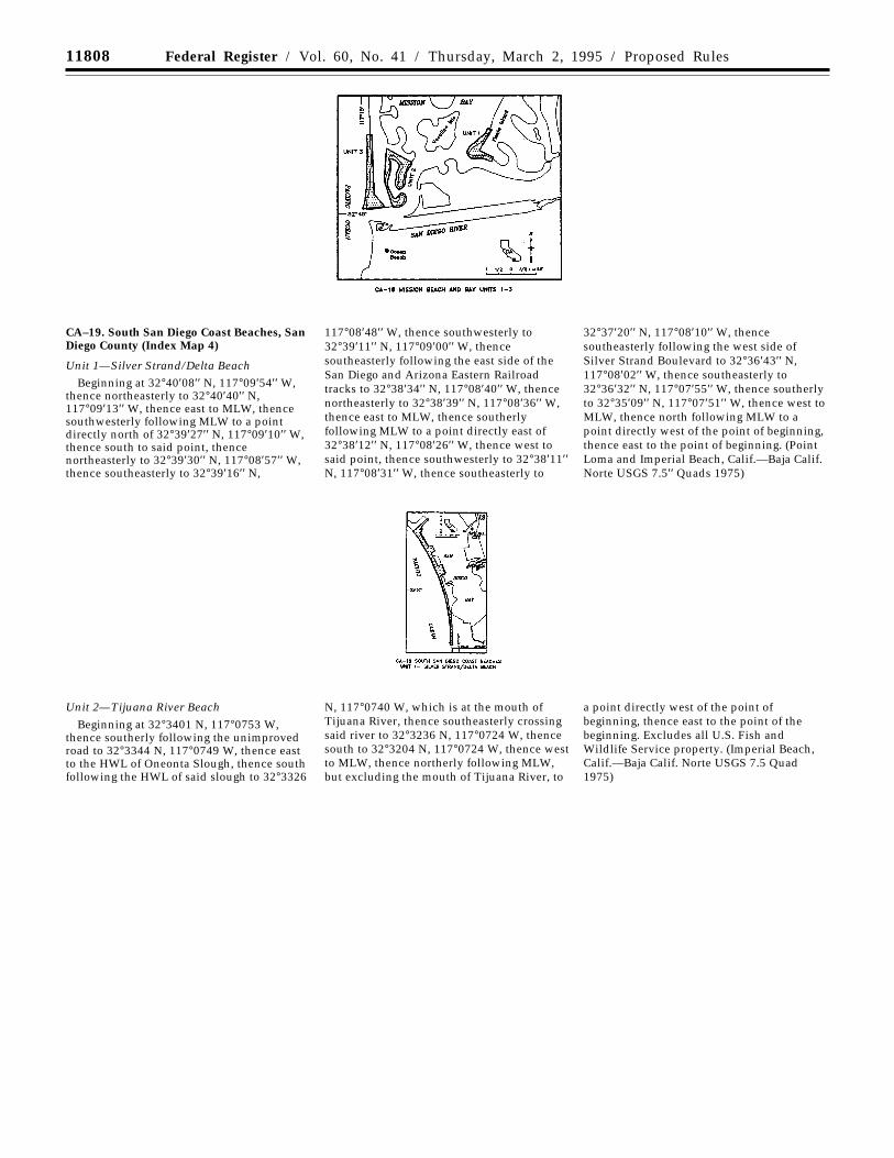
11808 Federal Register / Vol. 60, No. 41 / Thursday, March 2, 1995 / Proposed Rules
CA–19. South San Diego Coast Beaches, SanDiego County (Index Map 4)
Unit 1—Silver Strand/Delta BeachBeginning at 32°40′08′′ N, 117°09′54′′ W,
thence northeasterly to 32°40′40′′ N,117°09′13′′ W, thence east to MLW, thencesouthwesterly following MLW to a pointdirectly north of 32°39′27′′ N, 117°09′10′′ W,thence south to said point, thencenortheasterly to 32°39′30′′ N, 117°08′57′′ W,thence southeasterly to 32°39′16′′ N,
117°08′48′′ W, thence southwesterly to32°39′11′′ N, 117°09′00′′ W, thencesoutheasterly following the east side of theSan Diego and Arizona Eastern Railroadtracks to 32°38′34′′ N, 117°08′40′′ W, thencenortheasterly to 32°38′39′′ N, 117°08′36′′ W,thence east to MLW, thence southerlyfollowing MLW to a point directly east of32°38′12′′ N, 117°08′26′′ W, thence west tosaid point, thence southwesterly to 32°38′11′′N, 117°08′31′′ W, thence southeasterly to
32°37′20′′ N, 117°08′10′′ W, thencesoutheasterly following the west side ofSilver Strand Boulevard to 32°36′43′′ N,117°08′02′′ W, thence southeasterly to32°36′32′′ N, 117°07′55′′ W, thence southerlyto 32°35′09′′ N, 117°07′51′′ W, thence west toMLW, thence north following MLW to apoint directly west of the point of beginning,thence east to the point of beginning. (PointLoma and Imperial Beach, Calif.—Baja Calif.Norte USGS 7.5′′ Quads 1975)
Unit 2—Tijuana River Beach
Beginning at 32°3401 N, 117°0753 W,thence southerly following the unimprovedroad to 32°3344 N, 117°0749 W, thence eastto the HWL of Oneonta Slough, thence southfollowing the HWL of said slough to 32°3326
N, 117°0740 W, which is at the mouth ofTijuana River, thence southeasterly crossingsaid river to 32°3236 N, 117°0724 W, thencesouth to 32°3204 N, 117°0724 W, thence westto MLW, thence northerly following MLW,but excluding the mouth of Tijuana River, to
a point directly west of the point ofbeginning, thence east to the point of thebeginning. Excludes all U.S. Fish andWildlife Service property. (Imperial Beach,Calif.—Baja Calif. Norte USGS 7.5 Quad1975)
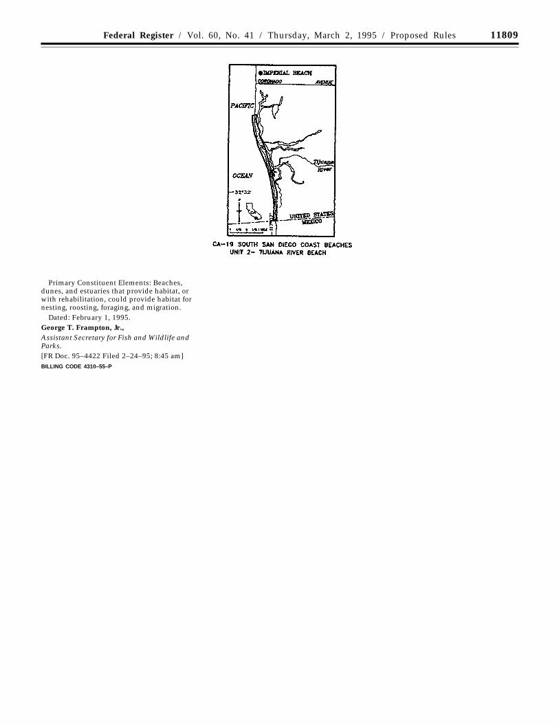
11809Federal Register / Vol. 60, No. 41 / Thursday, March 2, 1995 / Proposed Rules
Primary Constituent Elements: Beaches,dunes, and estuaries that provide habitat, orwith rehabilitation, could provide habitat fornesting, roosting, foraging, and migration.
Dated: February 1, 1995.George T. Frampton, Jr.,Assistant Secretary for Fish and Wildlife andParks.[FR Doc. 95–4422 Filed 2–24–95; 8:45 am]BILLING CODE 4310–55–P