Embed Size (px)
Citation preview
Port Phillip Planning Scheme Review
Audit Report
11.6 Public space Port Phillip has a vast network of public open space that includes parks and gardens, the foreshore and Albert Park Lake, all of which help to define the City’s character, provide leisure and recreation facilities for residents and visitors and provides for the conservation of natural and cultural environments.
11.6.1 Public open space and recreation As our City densifies, our public open spaces become increasingly important as it will need to cater for different and increased use as they will become many residents’ backyards. The City of Port Phillip does not have a current strategic plan to inform investment in public space. Council’s existing Open Space Plan was endorsed in August 2009 and is now out of date, with many of its recommendations realised. Since that time, Fishermans Bend was rezoned to the Capital City Zone, which will result in unprecedented population growth in the City of Phillip. Other emerging issues and challenges putting pressure on existing open spaces and amenities are:
• Increasing high density living, leading to a growing number of residents and visitors; • Growth in other strategic locations with public space shortfalls, such as St Kilda
Road; • Increasing community demand for higher quality public spaces and WSUD
initiatives; • Climate change - urban heat island effect, flooding and the aim to limit potable water
use; • There is an anticipated shortfall of sport and recreation open space and facilities in
the City, with current sporting facilities at or near capacity; • There is a rise in demand for informal open space and recreation opportunities.
Policy context Plan Melbourne 2017-50 includes a direction to create more great public places across Melbourne – the planning system will strengthen the design quality of public spaces and the interfaces between private development and the public domain (4.1). It also seeks to develop a network of accessible, high-quality, local open spaces (Direction 5.4). The Council Plan 2017-27 seeks to maintain and enhance liveability in a high density City, through designing, activating and managing public spaces that are safe and inviting places for people to enjoy and extending, connecting and diversifying our open space network to cater for increased demand (Outcome 4.1). To help achieve this, Council will develop a new Public Spaces Strategy and review Council’s design and technical standards for streets and public spaces.
Feedback Council officer feedback identified the need to be smarter about how we use public open space – to consider multi-functional uses, solar access, vertical and green infrastructure for urban spaces, greater canopy cover, irrigation and maintenance. Council officers also noted shortfalls of public open space in East St Kilda, Ripponlea and South Melbourne. With high inner-city land values making it difficult to purchase, this could justify an increase in the standard 5% public open space contribution requirement (8% for Fishermans Bend) in Clause 52.01 of the Scheme for certain areas.
131
Port Phillip Planning Scheme Review
Audit Report
Opportunities Council is committed to delivering a new Public Spaces Strategy to address open space deficit and facilitate smarter, multi-use and adaptable spaces. A new framework for public space management will address these drivers as well as provide clarity around the funding and financing of public space and will set priorities for the spending of public open space contributions. This Public Open Space Strategy will be able to inform:
• locations where there is a shortage of public open space • identify locations for new open space linkages • a potential increase in the 5% open space contribution for some areas • guidance on facilitating high quality, unencumbered, adaptable, multi-use and
resilient public open space • guidance for development of ‘hard’ and civic spaces and innovative greening • activation of our public spaces through local cultural events and urban art • the need for more detailed public open space local policy to implement the
objectives of the strategy and identify where land contributions for public open space are preferred over cash contributions.
Policy in the MSS should be updated to reflect strategies of the Sport and Recreation Strategy 2015-24 relating to the provision of active and passive open space and community facilities to meet the needs of a growing and changing population.
Recommendation 41: Review public open space policy and controls following completion of the Public Space Strategy to address public open space deficit and facilitate smarter, multi-use and adaptable spaces. Recommendation 42: Assess the potential for implementing revised public open space contributions in the Scheme.
Recommendation 43: Review the Sport and Recreation Strategy 2015 – 2024 and reflect current key issues and recreation trends and incorporate relevant strategies into the MSS where appropriate.
11.6.2 Activating laneways Local context The City of Port Phillip has over 42 kilometres of laneways which are often forgotten spaces. Yet their gritty charm and human scale provide great potential for them to become enticing and interesting places for residents, businesses and visitors.
Policy context Plan Melbourne 2017-50 includes a new direction to create more great public places across Melbourne (4.1) to
• Support Melbourne’s distinctiveness (Policy 4.1.1) • Integrate place-making practices into road-space management (Policy 4.1.2)
Port Phillip Planning Scheme Review
Audit Report
Plan Melbourne also links the existing atmospheric laneways of Melbourne to its liveability and reputation. The Council’s Activating Laneways Strategy (2011) encourages the use of Port Phillip’s network of laneways for unique public spaces. It defines ‘destination’ and ‘active’ laneways’ and includes design and Council process aspirations.
Opportunities The MSS should be revised to incorporate key strategic principles of the Activating Laneways Strategy 2011. Policy could be included in MSS for development to consider and address its interface with a laneway. It will also highlight the multi-functional role of laneways as unique public spaces that can serve as reminder of the City’s heritage, improve pedestrian connectivity and potentially become destination places in their own right.
Recommendation 44: Reflect the Activating Laneways Strategy 2011 in the MSS to highlight the multi-functional role of laneways as unique public spaces.
11.6.3 Foreshore Local context The foreshore is Port Phillip’s most outstanding natural and cultural asset and plays a very important social and recreational role for the local and wider population, with 11 kilometres of coastline between Sandridge Beach and Elwood.
Policy context Plan Melbourne 2017-50 identifies the need strike a balance between supporting a variety of coastal land uses and minimising risks to protect the coastlines and waters of Port Phillip Bay (Policy 6.5.3). The Council Plan 2017-27 seeks to enhance the environmental and recreational qualities of the foreshore to support diverse and distinctive neighbourhoods and places (Outcome 4.2). Design guidelines will be developed for key foreshore destinations including the St Kilda Triangle, St Kilda Marina and Port Melbourne Waterfront, including the effective management of the new lease for the St Kilda Marina. The existing MSS has policy on protecting and enhancing the foreshore by ensuring use and development is sympathetic to the coastal landscape and balances the competing demands of foreshore users, visitors and residents.
Opportunities Existing policy should be updated to reflect Council’s Foreshore Management Plan 2012 which provides a long term strategic vision and direction for the foreshore. Key considerations include the following:
o Reinforcing the unique characteristics of each of the five foreshore areas. o Recognising the need to define parameters for new development for renewal
and upgrades to facilities and infrastructure (potentially consider as part of a wider urban design framework).
133
Port Phillip Planning Scheme Review
Audit Report
o Addressing declining vegetation – consider applying an environmental overlay to protect significant coastal vegetation identified in plan to reinforce its ecological significance.
o Improving linkages and access to the foreshore for people of all ages and abilities.
o Planning for the impacts of climate change and sea level rise. o Protecting Aboriginal cultural heritage sites and promoting heritage values
and stories through art, natural and public realm improvements. Policy should also be generally consistent with the Victorian Coastal Strategy 2014, which replaced the Victorian Coastal Strategy 2008 (reference document in the Scheme).
Recommendation 45: Update foreshore policy to reflect relevant policies of the updated Foreshore Management Plan 2012 and be consistent with the Victorian Coastal Strategy 2014.
11.6.4 Overshadowing of public space and the foreshore Policy context The Scheme contains a suite of policy and controls that seek to prevent overshadowing of the public foreshore and public space throughout the municipality. However, there is a variation in the policy and controls throughout the scheme. Policy The MSS contains high-level policies seeking to protect public open space and the foreshore from overshadowing by private development. There is some repetition and variation in the wording of the policy throughout the MSS, with some being more specific than others. For example some policies seek to prevent overshadowing between a certain time/date during the winter solstice, while others reference mid-winter. Controls A number of Design and Development Overlays also apply to the foreshore and its surrounds, including DDO10 – Port Phillip Coastal Area which manages buildings, works and removal of vegetation on the coastal area while other DDOs (DDO1, DDO5, DDO6, DDO7, DDO23) implement building height restrictions to preserve sunlight to the foreshore. Currently, there are varied controls seeking to prevent overshadowing of the foreshore from Port Melbourne to Elwood with variations in
• the mandatory nature of the control – should vs must • the dates and time windows in which no or minimal overshadowing is to occur.
The DDO provisions for the St Kilda area (DDO6) the strongest stating: ‘Buildings must not cast a shadow onto any land within the Port Phillip Foreshore Reserve between 10.00am and 4.00pm on 21 June’.
Feedback Councillors sought a more consistent approach in overshadowing controls seeking to prevent overshadowing of the foreshore and major parks. A different approach is sometimes the result of the planning process, with public consultation and Planning Panels advice. This is the case for 1-7 Waterfront Place (DDO23) where Panel found that a shadow diagram analysis of a proposed development justified customised
Port Phillip Planning Scheme Review
Audit Report
controls for the site. Panel also sought a more flexible approach to minimise rather than prevent overshadowing of at certain times: “On the evidence, use of the beach at the solstice is limited and shadow effects, when sunny days occur during winter are equally limited but, at the Equinox and between the Autumn and Spring Equinoxes, use is consistent and sunlight is valuable.”
Opportunities A review of current policies relating to overshadowing at the foreshore in the MSS should be undertaken to provide a more consistent city-wide approach, where possible. Council may also consider strengthening and drawing together policies into an overshadowing section to raise the profile of current disparate policies, like in the Melbourne Planning Scheme (Clause 22.02 - Sunlight to Public Spaces). However, any changes to established overshadowing controls in schedules to the DDOs would need to be underpinned by further evidence like a broader foreshore overshadowing analysis. The potential to achieve mandatory controls is likely to vary across sections of the foreshore, having regard to the existing level of shadowing and the nature of public access/use.
Recommendation 46: Review existing overshadowing policy to aim for greater consistency across the City. Recommendation 47: Consider undertaking a broader sunlight to public spaces analysis for the wider municipality.
135
Port Phillip Planning Scheme Review
Audit Report
11.7 Housing and growth
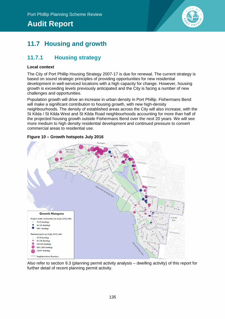
11.7.1 Housing strategy Local context The City of Port Phillip Housing Strategy 2007-17 is due for renewal. The current strategy is based on sound strategic principles of providing opportunities for new residential development in well-serviced locations with a high capacity for change. However, housing growth is exceeding levels previously anticipated and the City is facing a number of new challenges and opportunities. Population growth will drive an increase in urban density in Port Phillip. Fishermans Bend will make a significant contribution to housing growth, with new high-density neighbourhoods. The density of established areas across the City will also increase, with the St Kilda / St Kilda West and St Kilda Road neighbourhoods accounting for more than half of the projected housing growth outside Fishermans Bend over the next 20 years. We will see more medium to high density residential development and continued pressure to convert commercial areas to residential use.
Figure 10 – Growth hotspots July 2016
Also refer to section 9.3 (planning permit activity analysis – dwelling activity) of this report for further detail of recent planning permit activity.
Port Phillip Planning Scheme Review
Audit Report
Policy context There have been significant changes to State planning policy since the Housing Strategy was prepared in 2007 which has local implications:
• Rezoning Fishermans Bend in 2012 to accommodate approximately 40,000 new dwellings and 80,000 residents over the next 50 years. The City delivers close to 900 new dwellings a year and, as the Fishermans Bend is redeveloped, they will contribute an additional 800+ dwellings per year effectively doubling the City’s contribution of new housing.
• Plan Melbourne 2017-50 outlines how Melbourne will meet demand for housing diversity and growth, including by accommodating an increased percentage of new housing in established areas and neighbourhood activity centres.
• Introduction of a new suite of residential zones in 2013 provided councils with the opportunity to better direct the location and scale of residential change.
• Changes to the residential zones in March 2017 altered the purpose of some residential zones, mandatory heights and introduced a new garden area requirement.
Plan Melbourne aims to increase the percentage of new housing in established urban areas. It also promotes the role of neighbourhood activity centres as integral to the creation of 20-minute neighbourhoods (Policy 2.1.2). The Council Plan seeks to maintain and enhance liveability in a high-density City, through requiring well-designed buildings that contribute to safe, lively, high amenity places (Outcome 4.1) by updating the Scheme to ensure an effective framework of local policy and controls to manage growth.
Opportunities An up-to-date and robust Housing Strategy that sets out clear direction for housing development across the City will place Council in a better position to more effectively respond to and direct its population growth, while respecting the City’s heritage and neighbourhood character. A new Housing Strategy will also enable Council to holistically integrate the Fishermans Bend Urban Renewal Area into its overall housing vision. The majority of Port Phillip’s activity centres are located within areas with strong heritage and neighbourhood character values, constraining their growth potential. A new Housing Strategy should consider the potential to accommodate infill housing in established low-rise areas with proximity to neighbourhood activity centres and transport corridors, while remaining sensitive to heritage values. The Strategy should also consider the implications of the new mandatory minimum garden area requirement on infill development potential (introduced in March 2017). Although the majority of Port Phillip’s residential lots are too small to be affected by the new garden area requirement, it has the potential to significantly influence the built form outcomes on larger residential lots in Ripponlea, Elwood, St Kilda and St Kilda East. This also provides the opportunity to address a number of residential ‘review areas’ that were not included in Amendment C123, which implemented the reformed residential zones. These review areas require a more detailed assessment to determine the most appropriate residential zone. A number of other councils have developed a more prescriptive guidance on preferred housing typologies and design in conjunction with a housing strategy. Council should consider supporting a new Housing Strategy with neighbourhood character and design policy to better articulate its vision for preferred dwelling types in defined character areas. See section 11.2.4 (neighbourhood character) for further discussion.
137
Port Phillip Planning Scheme Review
Audit Report
Recommendation 48: Prepare a revised Housing Strategy to:
• take into consideration current factors and demand influencing housing provision
• update housing policy to account for the new residential zones and Fishermans Bend
• consider using the new zones to more effectively direct housing growth and diversity while respecting heritage and neighbourhood character values
• consider the review areas that were not addressed by Amendment C123 • continue to monitor and understand housing trends in the municipality.
11.7.2 Performance of housing policy The MSS housing policy defines five types of Housing Growth Areas: Substantial, Moderate, Incremental, Limited and Minimal (Clause 21.04-1).
Feedback Feedback from Council officers indicates that the current housing policy framework could be clearer on the level of growth that is expected to be accommodated within Neighbourhood Activity Centres. There has been a number of VCAT cases that have debated the definition and delineation of residential growth areas, with uncertainty created by the absence of maps in the scheme. There were a number of cases where proponents identified their sites as ‘strategic redevelopment sites’, without the support of Council. This could be due to the lack of a definition in the scheme on how to identify strategically appropriate locations for intensive housing redevelopment. A number of cases raised issue with Council’s interpretation of ‘Limited Growth Areas’ being inconsistent with the SPPF, with some sites appearing to be in locations with good access to public transport, jobs and services (refer to Appendix 4 – VCAT analysis). The Managing Residential Development Advisory Committee Report (July 2016) also reflected this view, stating that it is not appropriate to direct all or the overwhelming majority of growth to main roads and activity centres as this would present a missed opportunity for townhouses and other forms of medium density housing to be located off main roads, but near and close to public transport and activity centres.
Opportunities The five housing growth area definitions are generally based on sound strategic planning principles to direct housing growth to those locations within the municipality that have the greatest capacity for change – close to transport, shops and other services. However, the debate on the policy’s limitation of residential growth in areas very well serviced by public transport indicate the definitions should be reviewed in the new Housing Strategy to clarify where growth is expected to occur, including identifying strategic redevelopment sites. Other improvements include supporting the housing definitions with spatial representation to reduce dispute over interpretation and rationalising the categories into fewer types of growth areas to simplify the policy without losing strategic intent.
Port Phillip Planning Scheme Review
Audit Report
In the short-term, there is opportunity to clarify the definitions of the housing growth areas in a policy-neutral manner. At present, there are inconsistencies between the MSS housing growth area definition table and strategies.
Recommendation 49: Clarify housing residential growth area definitions within the MSS based on an updated Housing Strategy.
11.7.3 Fishermans Bend Over the next 40 years, the City of Port Phillip’s population is forecast to double with the redevelopment of Fishermans Bend. Both the level and rate of this growth will have significant implications for Council’s service and infrastructure needs, and the overall liveability of the City. Planning for the FBURA is being led by the State Government, in consultation with Council. Council is committed to ensuring Fishermans Bend is a great place to live, work and play and is advocating to the Victorian Government for the following priorities:
• an integrated transport plan for Fishermans Bend • an economic investment narrative and development plan for Fishermans Bend to
continue growing Melbourne’s economy • commitment to creating a diverse community • a comprehensive sustainable development plan • catalytic investment in infrastructure to direct development • informed density and quality design controls • achieving a 6 Star Greenstar Community in Fishermans Bend
The strategic planning for Fishermans Bend is planned to be finalised in 2018. The Review will need to holistically integrate the vision for the Fishermans Bend area into the MSS and remainder of the Scheme, along with identifying any interface issues and implications of this growth on surrounding areas.
Recommendation 50: Ensure best practice urban renewal planning and sustainable development outcomes for Fishermans Bend and holistically integrate this into the MSS.
11.7.4 Diverse and affordable housing
Affordable housing Local context The proportion of affordable housing units in the City of Port Phillip is declining, while affordable housing needs are growing:
• Rapidly increasing land prices and housing costs (from affecting the lower 50 - 60% of the income range in 1995 to affecting the lower 70% in 2015).
• Housing prices are twice as expensive compared with Greater Melbourne. • Less than 1% of private rental housing is affordable to low income households.
139
Port Phillip Planning Scheme Review
Audit Report
• Median priced houses or units are generally only affordable to persons in the highest 10 per cent of the income range. This represents a broadening of the housing affordability problem.
• Closure of private rooming houses and the subdivision of rental flats for home ownership or higher rental flats.
• Publicly funded housing is not keeping pace with demand. If no new social housing units are delivered in Port Phillip over the next decade, this crucial component of affordable housing as a proportion of the City’s total housing stock will reduce further, from the current 7.2% to a forecast 5.9% by 2025. This is at a time when the broadening affordability challenge means new target groups will place additional demand on the existing supply of affordable housing. This decline will detract from the City’s reputation as a diverse, inclusive and equitable City.
Policy context Plan Melbourne 2017-50 seeks to increase the supply of social and affordable housing in Melbourne, recognising that a range of programs across all levels of government is required (Direction 2.3). Part of its approach is strengthening the role of planning in facilitating and delivering the supply of social and affordable housing by exploring inclusionary zoning and other mechanisms to capture and share value created through planning controls. In June 2017, the State Government has introduced the Planning and Building Legislation Amendment (Housing Affordability and Other Matters) Bill 2017 to facilitate agreements (S.173) for the provision of affordable housing as part of development applications. The Planning and Environment Act is due to be amended (gazetted) in June 2018 to implement the Bill. The Council Plan seeks to increase affordable housing by increasing the supply and diversity of affordable housing aligned to priority local needs of low income families (including larger families), older people (in particular older single women), key workers (or low income wage earners), and singles at greatest risk of homelessness (Outcome 1.2). Council’s affordable housing strategy - In Our Backyard – Growing Affordable Housing in Port Phillip 2015-2025 – generally aligns with the directions of Plan Melbourne by using surplus Council property to deliver affordable housing and identifying opportunities to partner with the Victorian Government to develop planning mechanisms that can deliver social and affordable housing. The affordable housing strategy also contains an ambitious aim to facilitate new multi-unit residential development that provides 20% of new dwellings as affordable and investigating value-share opportunities as incentives, such as floor space ratios in association with development bonuses. The local planning policy for Fishermans Bend (Clause 22.15) includes policy to encourage all new development of accommodation uses over 12 storeys in height to allocate at least 6% of dwellings as affordable housing to a registered housing association or provider.
Opportunities Council recognises the need to respond proactively to ensure affordable and diverse housing remains available across the City. In the short term, the Review should update and strengthen affordable housing strategies in the MSS to reflect Council’s affordable housing strategy and new state policy. High land values in Port Phillip present a major constraint to investment in affordable housing. Planning mechanisms are needed that:
Port Phillip Planning Scheme Review
Audit Report
• both require and incentivise the provision of social and private affordable housing • facilitate delivery of a range of affordable housing products to address the
broadening housing affordability problem, including private rental and home ownership models for low to moderate income households
• maintain social housing delivered in perpetuity for future generations, through an affordable housing trust or similar arrangement
• provide the flexibility for contributions to be provided as units or ‘cash-in-lieu’. Affordable housing needs to be delivered through a combination of ‘opt-in’ (incentivised) and ‘mandated’ (inclusionary) planning mechanisms. In the medium-long term, Council should be prepared to respond to the direction of the state government reforms by:
• utilising potential new planning mechanisms when they become available (e.g. voluntary agreements)
• considering the introduction of discretionary target rates of affordable housing in the Scheme
• considering the use of development incentives (via a Floor Area Uplift mechanism) to facilitate the provision of social housing as a priority ‘public benefit’ in key growth areas
• continue to advocate for strengthened affordable housing planning mechanisms and processes and inform the state reforms.
Recommendation 51: Strengthen affordable housing policy in the MSS by reflecting the directions of state policy and In Our Backyard - Growing Affordable Housing in Port Phillip 2015-2025.
Housing diversity & adaptability Policy context Planning also has a role in facilitating a range of housing types to meet the needs of current and future residents. A key direction of Plan Melbourne 2017-50 is to provide greater choice and diversity across the city to enable housing choice, for larger households to remain within a preferred location, or for smaller households to downsize and ‘age in place’. This includes:
• establishing a diverse range of styles, types, forms and sizes (number of bedrooms) of houses that is suitable for all types of households, income levels and life stages;
• adaptive and flexible housing to meet changing household needs (e.g. design can be later consolidated or split to suit housing needs); and
• alternative housing (e.g. tiny houses, secondary dwellings/granny flats/bedsits).
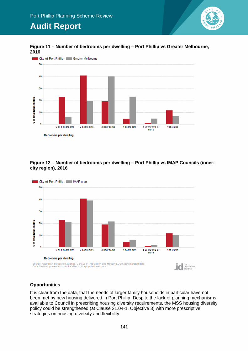
Feedback The VCAT analysis revealed at least one case for an apartment building that provided no larger dwelling types (3 or more bedroom dwellings). After considered Council’s current housing diversity policy in the MSS, VCAT found the proposal was acceptable. Refer to dwelling diversity in the VCAT Analysis in Appendix 4. Data The 2016 Census data reveals that the City of Port Phillip has a lower percentage of total households with 3 and 4 bedrooms than both Greater Melbourne and the IMAP area.
141
Port Phillip Planning Scheme Review
Audit Report
Figure 11 – Number of bedrooms per dwelling – Port Phillip vs Greater Melbourne, 2016
Figure 12 – Number of bedrooms per dwelling – Port Phillip vs IMAP Councils (inner-city region), 2016
Opportunities It is clear from the data, that the needs of larger family households in particular have not been met by new housing delivered in Port Phillip. Despite the lack of planning mechanisms available to Council in prescribing housing diversity requirements, the MSS housing diversity policy could be strengthened (at Clause 21.04-1, Objective 3) with more prescriptive strategies on housing diversity and flexibility.
Port Phillip Planning Scheme Review
Audit Report
Council should consider identifying acceptable ratios of housing diversity, particularly for key housing growth areas. This could take the form of a policy encouraging a minimum percentage of three bedroom dwellings in developments over 10 dwellings. Other considerations could be to encourage the provision for home-offices and extended family households, through features such as removable/sliding internal walls, flexible layouts and spaces with services located to allow adaptation, and dual key apartments which allow parts of dwellings to be occupied independently.
Recommendation 52: Update the Scheme to strengthen housing diversity policy by specifying the desired outcome and including policy support for alternative forms of housing.
Accessible housing Policy context An outcome of the Council Plan 2017-27 (Strategy 2.3) is to pursue universal accessibility for people with disabilities, children and older people. Plan Melbourne 2017-50 also seeks to facilitate housing that offers choice and meets changing household needs, including universal design (Policy 2.5.1). The new apartment standards (at Clause 55.07 and Clause 58 of the Planning Scheme) include an accessibility objective to ensure the design of dwellings meets the needs of people with limited mobility, with a standard for at least 50% of dwellings having universal design attributes like wide openings, hallways and adaptable bathrooms. More general accessibility objectives are also contained within ResCode standards for multi-unit developments. Commercial buildings need to comply with the Commonwealth Government’s Access to Premises Standards to have an accessible main entrance, common area, toilet and car parking.
Feedback Council officers raised the issue of facilitating housing design that is accessible for all ages and abilities, including residential care for older persons. The current MSS raises, as a key issue, the failure of the private market in adequately providing housing which is accessible and adaptable for people with disabilities and for older persons (to enable ‘aging in place’) and larger dwellings suited to households with children. However, there are no specific strategies relating to accessible housing.
Opportunities Council should consider including a strategy within the MSS to support the provision of accessible housing for people of all ages and abilities to promote accessible housing in all forms of development, including smaller-scale residential premises. See section 11.4.2 for universally accessible design.
Recommendation 53: Update the MSS to include policy support for accessible housing that is suitable for people of all ages and abilities.
143
Port Phillip Planning Scheme Review
Audit Report
11.7.5 Physical infrastructure Port Phillip’s growing resident, worker and visitor population will see further strain placed on existing transportation networks and other infrastructure (social, physical and public open space). This is exacerbated by an ‘at-capacity’ road network and the majority of local workers travelling to Port Phillip from other municipalities. Infrastructure contributions will be required to deliver infrastructure to support this growth.
Development contributions Development contributions are payments or works-in-kind towards the provision of infrastructure made by the proponent of a new development. For local infrastructure contributions through development applications, the Planning and Environment Act 1987 allows for it to be provided through:
• Development contributions plans (DCPs) – plans incorporated in the planning scheme to levy new development across a broad area (Development Contributions Plan Overlay)
• Conditions on planning permits – requiring provision of infrastructure (or payments) relevant to the planning application provided on or to the land
• Voluntary agreements – Section 173 Agreements for a planning scheme amendment request or permit application
A DCP can fund the acquisition of land for public infrastructure, and the construction of transport, community, open space and recreation infrastructure. A new system for Infrastructure Contributions Plans (ICP) was introduced in 2016 for regional and growth areas. The State Government has indicated this system will be extended to apply to strategic development areas in the metropolitan region at some stage.
Local context Council will experience increasing demands on its existing infrastructure in the coming decades and expanding or creating new infrastructure will be challenging from a cost and space perspective. As a result, it must consider ways in which it can fund infrastructure provision into the future. As planning controls open up new opportunities for more intensive forms of urban development, there is a need to ensure that such redevelopments make a fair contribution to the associated cost of delivering new community services, facilities and infrastructure. Currently, the Scheme has two areas within a Development Contributions Plan Overlay – the Port Melbourne mixed use area DCP (streetscape works) and the Fishermans Bend Urban Renewal Area.
Opportunities The use of development contributions should be considered as a potential funding option available to Council for its high-growth precincts and areas. Benefits of a traditional DCP process must be weighed up, given the considerable time and resources required, and the infrastructure funding commitments that come with it. Open space contributions are provided through Clause 52.01 of the Port Phillip Planning Scheme to help councils fund new open space or improve existing open space from the subdivision of land. This rate can be updated as part of the new Public Spaces Strategy - see section 11.5 on Public Space.
Port Phillip Planning Scheme Review
Audit Report
The state government has identified committed to reviewing infrastructure funding across the metropolitan area of Melbourne to ensure that the infrastructure required to support existing and future communities will be provided (Plan Melbourne Implementation Plan). The VPA and DELWP are currently working on introducing an infrastructure contributions system for strategic development areas within established areas of Melbourne. Strategic development areas include urban renewal areas, brownfield sites, activity centres and areas identified for substantial housing or employment growth. Consultation on a draft set of levies is expected to occur in 2018. Council should consider the outcomes and timing of the State-led review when considering future infrastructure funding options.
Recommendation 54: Review options to fund the infrastructure required to support a growing population.
145
Port Phillip Planning Scheme Review
Audit Report
11.8 Transport, parking & waste Road network congestion will continue to be an issue as our population grows with Port Phillip’s road network at capacity. Supporting people to travel by non-car modes is essential and will require better integration of the land use and transport system.
11.8.1 Integrated transport and land-use planning
Policy context The Council Plan seeks an integrated transport network that connects people and places (Outcome 2.1). An Integrated Transport Strategy will be developed to improve bike riding, walking network connectivity, safety and amenity. Council also seeks to create 10-minute walking neighbourhoods that give locals access to shops, community spaces and a strong sense of place (Outcome 4.2). Plan Melbourne 2017-50 encourages Councils to direct high-intensity uses to the Principal Public Transport Network (PPTN - Policy 3.1.4). The PPTN outlines the routes where high-quality public transport services are or will be provided. It also promotes the location of schools and other regional facilities near existing public transport (Policy 3.3.4).
Opportunities An integrated transport and land use policy framework will guide decision making to maximise access between residences, places of employment, markets, services and recreation. This supports the development of an effective transport system that is less reliant on the need for private motor vehicle transport. Housing growth and a mix of uses will need to be directed to areas which offer highest access to public transport, which in turn encourages walkable neighbourhoods and an increased take-up sustainable transport options. The review of transport and land-use policy within MSS should be informed by the strategic directions of the forthcoming Integrated Transport Strategy. A new Housing Strategy should also clarify the role of housing growth in proximity to the Principal Public Transport Network, particularly at interchanges, activity centres and where principal public transport routes intersect. Land use planning will also need to consider future transport facilities such as the new Anzac Station, which has the potential to have a transformative impact on this precinct for housing and jobs.
Recommendation 55: Update the MSS to reflect the outcomes of the Integrated Transport Strategy.
11.8.2 Sustainable transport modes Policy context The Council Plan 2017-27 directs that our streets and places should be designed for people, by prioritising walking, bike riding and public transport and pursuing universal accessibility (Outcome 2.3).
Port Phillip Planning Scheme Review
Audit Report
Plan Melbourne 2017-50 seeks to create pedestrian friendly neighbourhoods, with priority given to movement and needs of pedestrians (Policy 3.3.1). The current MSS has comprehensive sustainable transport policy which sets out a transport mode hierarchy to prioritise walking above all other methods of transport, followed by cycling, public transport, freight, multiple occupancy vehicles, with single occupancy vehicles last (Clause 21.03-2).
Feedback The majority of participants from the Planning Scheme Users Survey rated sustainable land use and development policy as either good or excellent (62%), but were less favourable about sustainable transport policy (42% rating it as good/excellent). Some users didn’t see the relevance of this policy for smaller private development, which doesn’t create the need for new transport infrastructure. Other users noted the policy was failing to result in increased bike infrastructure or a change in car land use patterns.
Opportunities Sustainable transport policy could be improved in the MSS by removing repetition and relocating advocacy strategies. The effectiveness of the sustainable transport mode hierarchy could be strengthened by linking it to
• a place-making approach that recognises our streets as important public places in their own right that contribute to the economic vibrancy and social functioning of our cities
• more detailed policies on how pedestrian and bicycle movement can be prioritised in larger developments
• encouraging larger developments to increase bicycle parking infrastructure and create more bicycle-friendly design outcomes.
Recommendation 56: Strengthen policies in the MSS on sustainable transport to promote the concept of placemaking in our streets.
11.8.3 Sustainable car parking Policy context The Council Plan 2017-27 envisions the demand for parking and travel to be moderated as our City grows (Outcome 2.2). This will be achieved by integrating land use and transport planning in the MSS and reducing reliance on cars by directing growth to areas well served by public transport and shops. Another priority includes developing updated parking provision rates for new development, including provision of car share vehicles. Minimum car parking requirements are mandated through Clause 52.06 of the Scheme. This is a state-standard provision that applies the same rates across the state. At present, these can only be reduced if an applicant seeks a lower rate through the permit process, and Council waives this requirement. This does not allow Council to require a reduction to the standard rates to encourage more sustainable development. To set alternative mandatory maximum or minimum car parking rates through the Planning Scheme, a Parking Overlay must be applied. This requires significant strategic justification and evidence.
147
Port Phillip Planning Scheme Review
Audit Report
Council’s Sustainable Parking Policy is used during the planning permit process to advocate for more sustainable car parking rates in new development. It is also used as a basis to waive the Clause 52.06 requirements. This will be reviewed and updated alongside the Integrated Transport Strategy. Currently the Port Phillip Planning Scheme applies Parking Overlay to Fishermans Bend which reduces the standard number of car parking spaces required.
Feedback There was strong support from Council officers on addressing a ‘policy gap’ on sustainable car parking rates. Currently the Planning Scheme contains state-standard parking requirements through Clause 52.06 (Car Parking). The Council’s statutory planners noted they consistently advocate for lower car parking provision in new development (where appropriate) by referring to the Sustainable Parking Policy. The Department has previously suggested to Council to use the Parking Overlay as an alternative to the Sustainable Transport Policy and Parking Rates Report (2007) reference document, to apply variations to car parking rates in its activity centres.
Survey The majority of respondents to the Planning Scheme Users Survey ranked sustainable transport policy in the MSS unfavourably, with one respondent indicating there was no strong policy support for reducing the number of cars in new development: “There is general acceptance that less cars and less traffic is desirable yet not (sic) policy strongly supporting reductions in car parking.” A recent study commissioned by Council collected survey data to examine car parking supply and demand and travel mode choice at a number of high-density buildings across the municipality. The study found there was an average on-site parking occupancy of 73% across the surveyed sites. This indicates that the private car parking provided within buildings is generally not fully utilised and that there may be scope to lower car parking rates in new development.
VCAT A review of VCAT cases (see section 9.1 of this report) found:
• In most cases, Council and VCAT supported a waiver of minimum car parking standards.
• In one case, Council opposed an application to waive car parking requirements for three new dwellings due to pressure in on-street parking in the area. VCAT disagreed, finding the location suitable given its proximity to public transport, share cars and shops.
• No permit is required when an oversupply of car parking (rate exceeding minimum standards of Clause 52.06) is proposed development unless Council applies a parking overlay.
Opportunities Benefits of a Parking Overlay include:
• potential to reduce congestion by encouraging the uptake of sustainable transport travel methods in areas facing significant levels of growth
Port Phillip Planning Scheme Review
Audit Report
• the ability to set lower or higher car parking requirements if an area experiences consistently higher or lower than average car parking demand
• ability to secure financial contributions for developments that provide less parking spaces (i.e. cash in lieu of parking waivers from parking requirements) to fund other car parking facilities or public or active transport initiatives
• ability to secure cash in lieu of parking waivers for commercial developments to accommodate additional traffic within an activity centre that a new business is expected to generate.
A Parking Overlay with varied rates must be supported by a car parking plan that provides strategic justification for the rates specified in the overlay. There is a significant level of strategic work that must accompany the introduction of a Parking Overlay to an area. Council should determine whether a Parking Overlay would be beneficial for certain activity centres or high-growth areas of the municipality. The Victorian Government has identified the possibility of updating the state-wide car parking rates of the head car parking provision (Clause 52.06) in the context of transport mode shifts, lifestyle and technology changes and densification – see the Reforming the Victoria Planning Provisions Discussion Paper, October 2017 (page 57).
Recommendation 57: Consider using the Parking Overlay to require more sustainable car parking rates (including maximum rates) for new office and residential development in select high-growth locations close to public transport, shops and services.
Recommendation 58: Investigate the potential to secure development contributions for sustainable car parking rates to fund active transport initiatives.
11.8.4 Visitor parking Feedback from Council officers was that, for many larger development applications, developers were requesting a waiver or reduction of state-standard on-site visitor parking rates. A request to waiver or reduce the rate of visitor parking is considered on a case-by-case basis, by surveying parking demand in the vicinity of the site and considering the level of additional demand a development may provide. However, this method may not accurately account for the cumulative impact of a number of developments approved around the same time. This may have implications for the demand for on-street parking in an area which is often a concern of surrounding residents. A waiver or reduction in the state-standard visitor parking rate is often appropriate where a site has suitable alternatives for visitor car parking. A reduction may also have benefits in reducing the provision of under-utilised car parking spaces which would add to the development costs and affordability of new housing. The Integrated Transport Strategy will define how Council will manage on-street parking into the future through smart street management, to balance and reconcile the demands on our street network as our city grows. A more strategic analysis of setting more sustainable levels of visitor parking rates in private development rates can be further explored with a potential Parking Overlay (Recommendation 57).
149
Port Phillip Planning Scheme Review
Audit Report
11.8.5 Car parking design A number of DDOs have requirements for car parking levels to be of a minimum floor to ceiling height of 3.5m so that it has the potential to be repurposed for habitable uses later, if the demand and utilisation of car parking is reduced. A more consistent policy on flexible and adaptive reuse of car parking levels in buildings should be considered in the Review. Another issue raised by Council officers was on the design of standard car parking stackers not being large enough to accommodate some vehicle types, and only 25% of car parking stackers required to accommodate a 1.8m clearance height, potentially increasing on-street car parking demand. These issues should be further explored in conjunction with the Integrated Transport Strategy and sustainable parking policy.
11.8.6 Green Travel Plan A Green Travel Plan is a process undertaken by a site developer to assess, develop and implement initiatives to facilitate and encourage the use of more sustainable travel options. Larger non-residential developments are required to provide a Green Travel Plan in accordance with the Environmentally Sustainable Development Local Planning Policy in the Scheme (Clause 22.13). Council often includes this as a permit condition for larger residential developments. Officer feedback suggested Green Travel Plans may not be working as effectively as they could, with little guidance on the appropriate contents of Green Travel Plans (e.g. threshold for acceptability and encouraging best practice). There is also little in the way of follow-up on whether Plans have been implemented, as this requires enforcement action. This should be further explored in conjunction with a potential Parking Overlay. A template Green Travel Plan policy that sits outside the planning scheme may be useful in providing more detailed advice to developers on expected outcomes.
11.8.7 Car share The MSS aims to reduce the impact of vehicles on local areas by supporting shared parking facilities in retail shopping strips. Council’s Car Share Policy 2016-21 supports the provision of car share vehicles within new developments, alongside a reduction in the number of private car spaces provided on site, to reduce the need for car parking and car ownership and to supplement the local on-street car share network. Council’s Green Transport Plan condition requires that a ‘share car’ parking space is provided within the development for use by residents of the proposed development. However, Council officer feedback indicated there were issues with car share viability in some developments due to lack of public access to private buildings and costs to body corporate. Council officers also noted car share operators don’t favour car share parks located in basements of private buildings as they are not well utilised and on-street provision is preferable. Council’s Car Share Policy seeks to prioritise car share provision outside of residential or commercial properties for greater convenience.
Port Phillip Planning Scheme Review
Audit Report
Recommendation 59: Consider ways to improve policies relating to car parking, including:
• facilitating flexible car parking design • guidance to improve Green Travel Plans • supporting car share facilities in on-street locations, or where demand is
demonstrated.
11.8.8 Services in higher density development
Bicycle parking The Port Phillip Planning Scheme contains a state-wide provisions, at Clause 52.34 Bicycle Facilities, that sets out bicycle parking rates for a new use or for where the floor area of an existing use is increased. Feedback from Council officers indicate the minimum bicycle parking rates per dwelling (at 1 for every 5 dwellings) is too low to encourage sustainable transport options. A post-occupancy survey of 13 high-density buildings across the municipality found that bicycle parking rates vary widely, but are generally underprovided for in new developments. One building had a formal supply of 30 bicycle parks and an observed demand of 60 bicycle parks (200% demand). The provisions are set by the State Government and do not allow Council to vary the requirements through a schedule. At present, the only way at present for Council to vary bicycle parking rates is through applying the Activity Centre Zone, however this is a highly complex zone and should not be used solely to increase bicycle parking provisions. Council can encourage a reform of the bicycle facilities provision through advocacy to the Minister for Planning. Council can provide policy support in the MSS to encourage greater provision and better design / access of bicycle spaces and facilities within developments.
Recommendation 60: Support more and better designed bicycle spaces and facilities within private development, particularly where car parking is reduced.
Waste management
Policy context Council’s vision is to achieve a sustained reduction in waste (Outcome 3.5 of the Council Plan 2017-27) by reducing waste and maximising recycling and diversion from landfill and managing waste collection. One of Council’s key priorities over the next four years is to develop and implement a new municipal Waste Management and Resource Recovery Plan, pursuing waste innovations in Fishermans Bend and updating the Waste Management Guidelines for apartment developments. Plan Melbourne 2017-50 seeks to improve waste and resource recovery systems to meet the logistical challenges of medium and higher-density developments (Policy 6.7.2).
151
Port Phillip Planning Scheme Review
Audit Report
The recently introduced apartment developments standards (Clause 55.07 and 58) in the Scheme provides a standard for waste and recycling management facilities to be designed and managed in accordance with a Waste Management Plan approved by the Council, however this is not a mandatory requirement.
Opportunities The Waste Management Guidelines are currently being reviewed by Council to strengthen sustainable waste outcomes with stronger waste diversion targets from landfill. Council should reflect its waste management policies in the MSS. The new waste management standards in Clause 58 are performance based, meaning Council has less prescriptive control on design outcomes. There is the possibility a development may meet the Clause 58.06-3 objective without being in accordance with Council’s preferred waste requirements. There is the opportunity for Council to strengthen the requirement for a Waste Management Plan to be provided for a range of development types in accordance with its Guidelines.
Recommendation 61: Update the MSS to include waste management requirements for multi-unit and high density development, which maximise recycling and diversion from land fill.
Recommendation 62: Incorporate an application requirement for high-density development that requires Waste Management Plans to be consistent with Council’s Waste Management Guidelines, once developed.
Loading requirements The apartment standards in Clause 58 of the Planning Scheme do not include loading requirements and service vehicle areas for residential developments over a certain threshold (e.g. high-density apartment developments). This can create circumstances where trucks need to temporarily park on street, which can have traffic implications for certain areas. Guidance should be provided in the Urban Design Local Planning Policy (Clause 22.06 – Urban Design Policy for Non Residential and Multi Unit Residential Development) to encourage developments to provide loading areas on site to prevent these situations from having a cumulatively negative impact on building frontages and amenity. Also see section 12.2.7 of this report (review of Clause 22.06) for further discussion of this issue. Where possible, developments should be encouraged to integrate or share these areas where possible.
Recommendation 63: Update design policy for higher density residential development to encourage the provision of space that will accommodate on-site loading where development is on a busy road.

153
Port Phillip Planning Scheme Review
Audit Report
12 Effectiveness and efficiency This section reviews the structure and the content of the Port Phillip Planning Scheme to determine whether improvements can be made. Key considerations include:
• updating content and removing redundant controls • considering permit exemptions to improve efficiency • ensuring controls are clear and reducing repetition to improve effectiveness.
12.1 The Municipal Strategic Statement Local context There is no prescribed format for the structure of the MSS, but widely accepted principles include that the structure should be logical and provide a clear link between state and local policy.
Feedback Council officers raised a number of issues with the length and ambiguity of the current MSS and the way the strategies have been drafted. They suggested:
• substantially reducing the length • reducing duplication and inconsistency within the scheme • remove references to ‘encourage’ and ‘ensure’ in the strategies • adding maps to provide more spatial guidance and a visual interpretation of policy.
The responses to the Planning Scheme Users Survey indicate there is wider support for the Scheme being simplified. The three most frequently mentioned responses were:
• ‘Reduce unnecessary and repetitive policy’ (noted by 60% of respondents); • ‘Rewrite policy to be more succinct’ (mentioned by 45%); and • ‘Improve the structure to make it easier to follow’ (40%).
Feedback from the Planning Panel that implemented the last planning scheme review (Amendment C62, 2011) noted there would be merit in Council streamlining the content without changing the intent of the new LPPF to reduce the length and this improve its readability:
“at over 120 pages in length and, arguably, reflecting the complexity and diversity of the City of Port Phillip, there would be some merit in Council judiciously reviewing and, where possible, streamlining the content without changing the intent of the new LPPF”.
Opportunities Port Phillip’s existing MSS contains the relevant information, however it has a unique structure that doesn’t directly follow the preferred model set out in the practice note. This should be reviewed to ensure the MSS follows a logical format with:
• descriptive content of the municipality upfront • key planning issues and influences that help to demonstrate local and demographic
trends • a statement on Council’s vision for the City’s future • a clearer strategic framework plan that provides the spatial representation of key
strategic directions and issue of the municipality
Port Phillip Planning Scheme Review
Audit Report
• strategic directions that set out how Council will address the key issues affecting the City.
This helps to lay out the foundations for the detailed objectives and strategies of the remainder of the MSS. The remainder of the MSS, which sets out detailed policies and objectives on land use and development can be set out in a format of Council’s choosing. One approach worth considering is to set out the policies and objectives to broadly follow the themes of the SPPF. The benefits of this approach is to better align and integrate local and state policy, as it more clearly draws a link between state and local policy and it reduces repetition between the two policy levels. This will also assist in translating Council’s local policy into the proposed new integrated planning policy framework being developed by the State Government (see section 6.3.10 for details on the Smart Planning Program). Throughout the remainder of the MSS there are common issues that could be improved, including:
• clarifying overarching motherhood policy statements • using active verbs and plain English format • reducing repetitive strategies between themes • making policies more concise • removing inconsistent strategies, where possible 35 • adding maps at the end of each theme • removing strategies not relevant to planning from the Scheme.
Recommendation 64: The MSS will need to be restructured to more closely reflect the themes of the State Planning Policy Framework to improve clarity and reduce duplication. Council should take the opportunity to work with the state government to implement the proposed integrated planning policy as part of the Smart Planning reforms.
Reference documents Reference documents provide background information to assist in understanding the context within which a particular policy or provision has been framed. Reference documents have only a limited role in decision-making as they are not part of the planning scheme. They do not have the status of incorporated documents, nor carry the same decision-making weight. They are mentioned frequently throughout the Port Phillip Planning Scheme, however, as they often reflect Council or State Government strategic documents, they are prone to becoming outdated over time, or superseded by a newer version of policy. All reference documents should be reviewed to ensure they are current, provide useful background information or general advice to applicants, or will assist in understanding the scheme.
35 Some conflicting planning policies are unavoidable and must be weighed up in decision-making in favour of net community benefit – see Clause 10.04 of the Port Phillip Planning Scheme.
155
Port Phillip Planning Scheme Review
Audit Report
Recommendation 65: Review all reference documents to ensure they are still current, relevant and useful.
12.2 Local Planning Policies The role of a Local Planning Policy (LPP) is different to that of the MSS. LPPs should not contain the local strategic direction of a planning scheme. Rather, its purpose is to guide the exercise of discretion under a planning scheme controls (relating to a planning permit trigger under a zone, overlay or particular provision) to deliver an objective or strategy of the MSS.
12.2.1 Area-based local policies (Clause 22) Local context There are two area-based LPPs in the Scheme that contain detailed guidance on strategic direction in relation to activity centres at Carlisle Street and Bay Street. These area-based LPPs aim to implement structure that are intended to set the long term strategic direction for land use and development, along with some more detailed built form objectives. The State Government is proposing an integrated state and local planning policy framework that is proposing to remove this distinction between the LPPs and the rest of the MSS – see section 6.3.10 (Smart Planning Program). If this is implemented as proposed by the State Government, this will require all Local Planning Policies to be translated into the MSS at some point.
Feedback In the Planning Panel for Amendment C52 - South Melbourne Central, the Panel found that the local policy could be dispensed with and re-distributed into the MSS or the DDO. The June 2007 Making Local Policy Stronger Ministerial Report noted the proliferation of local planning policies in many planning schemes were attempts to apply specific land use controls to local areas, which is more effectively achieved through the zone and overlay provisions. The Report also noted the tendency for Councils to ‘load-up’ their LPP with as much detail as possible to provide ‘insurance’ against any possible outcome, resulting in an over bloated LPPF where important messages are lost. Although this structure can be perceived as a useful ‘one-stop shop’ for detailed policy on an area, if not carefully drafted, it tends to result in policies that repeats the MSS and planning controls and, at times, does not relate to a discretion in the scheme.
Opportunities Best practice advice is to deconstruct these policies to include the broad strategic objectives in the MSS and use the zones and overlays to deliver the policy objectives. The benefits of this approach include:
• reducing repetition and streamlining the LPPF • making better use of the zone and overlay controls • creating an LPPF that is more easily understood by decision-makers and the
community • strengthening the role of, and policy within, the MSS
Port Phillip Planning Scheme Review
Audit Report
• making it easier for practitioners and the public to navigate and decipher policy direction.
Rolling the area-based policies into the MSS is consistent with the proposed integrated Planning Policy Framework reforms that are proposed by the State Government as part of the Smart Planning program. Detailed built form requirements in the LPPs that are not suitable for the MSS may be able to be added to the relevant DDO. The update of the remainder of the LPPs should consider how the proposed reforms will affect the policy and ensure they can be more easily retrofitted to the future Integrated Planning Policy Framework.
Recommendation 66: Relocate the area-based Local Planning Policies to the MSS and other relevant parts of the Planning Scheme.
12.2.2 Non-residential uses in the residential zone (Clause 22.01)
Context Clause 22.01 – The Non-residential uses in the residential zone was introduced as part of the last planning scheme review (Amendment C62 in 2011) to guide discretion in applications for non-residential uses such as convenience stores, restaurants and medical centres in the former Residential 1 and 2 Zones (replaced by the reformed residential zones in 2013).
Feedback Council officers suggested considering the implications the reformed residential zones to respond to changes in permit discretion. Officer feedback also indicated there was not comprehensive guidance for other types of non-residential uses that typically receive more community concern, like veterinary centres. However, when reviewing a VCAT decision which considered a proposed veterinary centre in a residential zone, the Tribunal 36 had regard to the policy objectives at Clause 22.01. In that decision, VCAT ultimately affirmed Council’s decision to refuse the permit, citing that the proposed land use did not meet the locational criteria outlined for non-residential uses in the residential zone, and was not consistent with the outcomes sought by local policy.
Opportunities Overall, the outcomes of the VCAT case and recent Council decisions indicate that policy objectives are being considered. The policy continues to provide useful guidance for non-residential uses in the residential zones. The changes to the residential zones made medical centres as-of-right (under 250sq.m) in the General Residential Zone, Neighbourhood Residential Zone and the Residential Growth Zone, along with a small shop and office in the Residential Growth Zone.
36 Paws v Port Phillip CC [2015] VCAT 1833 (19 November 2015)
157
Port Phillip Planning Scheme Review
Audit Report
There is no need to change policy guidance for remaining permit discretions where medical centres are now section 1 use. In regards to the new permit discretions in the RGZ – shop and office, they are not expected to have fundamentally different impacts to the types of uses the policy currently covers - convenience shops and medical /veterinary centres given size limitations. The existing Clause 22.01 policies that are based on protection of residential amenity is still relevant. Recommendation 67: Retain and update local policy on non-residential uses in the residential zones to reflect permit discretions in the reformed zones.
12.2.3 Backpacker’s Lodges (Clause 22.02) Policy context Clause 22.02 -The Backpackers’ Lodges Local Planning Policy was introduced in the last planning scheme review (Amendment C62, 2011) to formalise an adopted Council policy - Backpackers’ Lodges in the City of Port Phillip, March 2000. It seeks to protect the conversion of social housing and private rooming houses to backpackers’ lodges and outlines requirements relating to their location, design and operation.
Feedback Council has been unsuccessful at arguing before VCAT that a proposal to use land for a backpackers’ lodging does not meet the policy objectives of Clause 22.02 (Backpackers’ lodges) on a number of occasions. See section 9.1 of this report for a VCAT analysis of backpackers’ lodges.
Location criteria Both VCAT decisions supported the proposed backpackers’ lodges given their proximity to:
• Good local public transport options; • commercial areas or zones; • Shops and services in activity centres;
In both cases, VCAT considered the policy to locate backpackers’ lodges away from residential areas, finding:
• The location of a backpackers’ lodge in proximity to residential uses does not make the proposal unacceptable;
• Mixed use buildings can be considered as a ‘residential area’; • Transition areas between residential and commercial zoning may be appropriate.
Noise impacts Officer feedback indicated that noise is a major issue with regards to the off-site impacts of Backpackers’ Lodges. The VCAT cases indicate that noise impacts are carefully considered by the Tribunal:
Port Phillip Planning Scheme Review
Audit Report
“I acknowledge that it is appropriate that the Tribunal exercise some caution about the potential off-site amenity impacts of approving a backpacker’s facility, particularly in a residentially zoned area 37”
Both VCAT cases considered the noise impacts of each proposal on its merits and considered impacts to be reasonable with appropriate venue management conditions. However, both decisions considered these noise factors were given less weight due to existing conditions in the area - with the high-degree of traffic noise at St Kilda Junction for the McGuire case and the existing levels night activity an area is subject to in the Raff Holdings case:
“I am also mindful that the Clause 22.02 objectives need to be sensibly considered in light of this being a less than pristine local area 38”.
Definitions Officers raised concerns about an exemption provided by Clause 52.23 (Shared housing) intended to benefit rooming houses, that also exempts the use of land for backpackers’ lodge in residential areas if it is less than 10 habitable rooms. There is some potential that this issue will be addressed by the State Government, with the Minister for Planning currently considering reforms to the VPP to stipulate that the exemption only applies to rooming houses and community care accommodation.
Opportunities Despite Council’s lack of recent success in opposing backpackers’ lodges at VCAT, the decisions indicate that the policies of Clause 22.02-3 on location criteria and amenity impacts are being carefully considered. The tensions that exist with backpacker’s lodges are similar to issues raised with licensed premises and residential amenity impacts in activity centres, due to our commercial areas intensifying and becoming increasingly mixed-use. Overall, the policy objectives are being considered and implemented. Council should continue to monitor the performance of this policy over the coming years to potentially strengthen policies relating to venue management and noise mitigation. Further, as backpackers’ lodges will naturally locate in similar areas, close to popular tourism precincts like St Kilda, there should be a greater focus on demonstrating the cumulative impact of backpackers’ lodges (and their interaction with licensed premises). Although Council has not recently opposed any permits on this basis, it should monitor the policy’s effectiveness at managing cumulative impacts over time. There are a couple of a minor anomalies within the policy that will need to be updated, including an error in the policy reference to the SPPF provision. Recommendation 68: Retain and update policy on backpacker’s lodges to correct minor anomalies.
37 Raff Holdings Pty Ltd v Port Phillip CC [2014] VCAT 996 (14 August 2014) 38 Raff Holdings Pty Ltd v Port Phillip CC [2014] VCAT 996 (14 August 2014)
159
Port Phillip Planning Scheme Review
Audit Report
12.2.4 Caretaker’s houses in industrial and business zones (Clause 22.03)
Clause 22.03 – Caretaker’s houses in industrial and business zones was introduced to the Scheme in the 2006 review (Amendment C62, 2011) to formalise an adopted Council Policy (Port Phillip Practice Notes, Policy no. 15 – Caretaker’s Dwellings). It introduced policy relating to the design and operation of caretaker’s houses in Industrial 1 and 3, and Business 3 Zones. During consultation, Council officers suggested updating the zone references following the 2013 zone reforms. The reformed zones generally allow more uses within these zones, however accommodation (other than Caretaker’s house) remains prohibited in the Industrial zones. Within the Commercial 2 Zone (formerly the B3Z) a Motel and Residential hotel are now allowed with a permit. The number of permit applications for caretakers’ houses has seen a significant decline in recent years following rezoning of the majority of Port Phillip’s industrial land in the Fisherman’s Bend Urban Renewal Area to Capital City Zone (via Amendment C102 - July, 2012). Despite this, the policy position continues to be relevant for the remaining small parcels of industrial land to ensure the City’s remaining industrial-zoned land is protected from encroachment by non-industrial uses. The zone references in Clause 22.03 and Port Phillip Practice Notes, Policy no. 15 – Caretaker’s Dwellings – Reference document should be updated. Recommendation 69: Retain and update local policy on caretaker’s houses in industrial and business zones to reflect the zone reforms.
12.2.5 Heritage policy (Clause 22.04) Policy context Plan Melbourne 2017-50 identifies the opportunity to stimulate economic growth through heritage conservation (Policy 4.4.3). This recognises the need for heritage policy to be flexible enough to enable the regeneration of heritage assets through adaptive re-use to create unique and attractive functional places. The Burra Charter 39 is guidance for the conservation and management of places of cultural heritage significance and sets a standard for those who make decisions about cultural heritage significance in Australia. The Burra Charter notes that change may be necessary to retain cultural significance (heritage values), but is undesirable where it reduces it (Article 15.1).
Feedback 2006 Audit The 2006 Planning Scheme Review identified the need for a number of refinements to the Heritage Local Planning Policy at Clause 22.04, only some of which were undertaken. It is
39 Australia ICOMOS Charter for Places of Cultural Significance, The Burra Charter, 2013 (Burra Charter)
Port Phillip Planning Scheme Review
Audit Report
timely that a comprehensive review of the Heritage Local Planning Policy be undertaken to strengthen and broaden scope of Heritage Policy to address different typologies and accommodate sensitively designed development.
Survey The Planning Scheme Users Survey identified the policy as the most frequently used policy, however results on its performance were varied, with approximately half of respondents rating it favourably. About 17% of respondents rated it as ‘poor’ or ‘very poor’ and raised the following concerns:
• The policy contains arbitrary and excessive restrictions that don’t reflect present and future needs for well balanced, higher density housing;
• Prescriptive heights and setbacks need to be more flexible to accommodate new and interesting designs, rather than considering the streetscape as a 2D Hollywood set;
• The 10 degree viewline rule is nonsensical in instances where a ridgeline would hide new work;
• Clearer guidance and more flexibility is required for sections that have limited visibility from the street.
Officers Feedback from Council officers also raised the inflexibility of the prescriptive measures as an issue. They noted the 10 degree viewline policy for additions or alterations to heritage places has been designed to apply to a single-storey house and has limited applicability to other building typologies (e.g. non-residential buildings) and roof forms (e.g. Edwardian roof forms). The development of Fishermans Bend will also see a number of heritage buildings redeveloped to a higher scale, with industrial heritage fabric.
VCAT A number of VCAT cases took a contextual approach and accepted design proposals as appropriate that didn’t strictly comply with the Policy’s 10 degree sightline performance measure - as detailed in Appendix 4. In one case, VCAT noted that if Council wants strict compliance with the 10 degree measure, it should elevate the policy measure as a control. A number of VCAT cases also considered the demolition policy, often setting aside Council’s decision by finding buildings structurally unsound. One case 40, however approved demolition of two significant heritage places that were structurally sound, contrary to the policy, finding that demolition would improve the adjacent heritage place. Findings about the demolition policy include:
• The policy would prevent the demolition of any significant heritage building unless it is structurally unsound, affording the buildings greater protection than they would have if on the register of buildings of State significance under the Heritage Act 1995.
• The policy significantly narrows the broad discretion given under the head provision (Clause 43.01 – Heritage Overlay) which may grant a permit to demolish a building and called for a resolution of conflicting controls.
40 Milgrom v Port Phillip CC [2014] VCAT 439 (17 April 2014)
161
Port Phillip Planning Scheme Review
Audit Report
Panels The Planning Panel for Amendment C143 (Fishermans Bend Heritage Study) noted the tension between Clause 22.04 (Heritage Policy) demolition policy and the citation, which recommends a less restrictive approach to demolition. The Panel also noted a tension between the Policy’s built form guidance and the scale of development envisaged by DDO30 in the Fishermans Bend Urban Renewal Area:
“In areas where redevelopment at significant scale is envisaged, a policy of ‘concealment’ of new development of land within the Heritage Overlay, as envisaged by the Clause 22.04 policy, will not necessarily strike the right balance. The Policy seems more suited to low scale residential heritage places or precincts than areas identified for intensive redevelopment.”
Opportunities It is timely that a comprehensive review of the Heritage Local Planning Policy take place, as part of Council’s broader heritage review program. The following revision or improvements should be addressed:
• Revise the viewline requirement (Performance Measure 1) to address a wider range of building typologies, including identifying circumstances when a variation to the measure is acceptable.
• Explore options for new exemptions from the viewline requirement to allow innovative and contextual roof forms.
• Clarify the ‘demolition’ policy. Despite VCAT findings, the Burra Charter 2013 is clear in its policy that that demolition of significant fabric of a place is generally not acceptable (15.3) except minor demolition as part of conservation.
• Better define ‘design excellence’ for replacement buildings. • Review the format and consistency to reduce repetition (including between the MSS
and local policy) and simplify language for improved clarity. • Include a specific section on the conservation of heritage fabric (this is currently
missing or mixed in with other policies) to discourage works that would damage heritage fabric.
• Consider whether any of the guidelines that are contained in the Design Manual reference documents (e.g. Fisherman’s Bend Guidelines, Garden City Guidelines in the Design Manual) could be incorporated into the local policy to give them more weight).
• Ensure a revised heritage local planning policy is be consistent with the principles of The Burra Charter: The Australia ICOMOS Charter for Places of Cultural Significance, 2013.
Recommendation 70: Comprehensively review the heritage policy to strengthen and broaden its scope to respond to a broader range of development types, including commercial and industrial properties.
Heritage & Environmentally Sustainable Development One of the priorities for Council in Outcome 3.2 of its Council Plan 2017-27 - for a city with lower carbon emissions is to develop guidelines that enable an increased uptake of environmentally sustainable design features, including rooftop solar, in heritage areas. It is recognised that the retention of heritage building fabric has environmental sustainability benefits in reducing the energy usage associated with demolition, waste disposal and new
Port Phillip Planning Scheme Review
Audit Report
construction and conserving the embodied energy (mining and manufacturing of materials) in existing buildings. However, Environmentally Sustainable Development (ESD) and heritage policy within the planning system tend to clash where ESD facilities installed on heritage buildings are visible from the street. This affects the ability for some heritage building owners to achieve modern sustainability outcomes for both internal comfort and energy consumption and associated costs. The Heritage Overlay triggers a permit requirement for minor buildings and works including domestic services, solar energy facilities and rainwater tanks if visible from the street. For many properties, a visible location may be the only feasible or efficient option for installing energy efficient facilities. However, there is no clear policy guidance on what measures can be undertaken to reduce the visual impact of these facilities on the heritage value of the property.
Feedback Respondents for the Planning Users Survey also raised this issue: “The weighting required between heritage and ESD was not well recognised.” Council officers highlighted the issue of heritage controls overriding sustainable design initiatives such as solar PV panels and identified the need for a policy position. They suggested supporting particular ESD features visible from the street if it is removable and doesn’t affect the heritage fabric of a building.
Opportunities A Local Planning Policy within the Yarra Planning Scheme (Clause 22.02) outlines development guidelines for sites subject to the heritage overlay. The policy allows ESD facilities on heritage buildings where:
• there is no reasonable alternative location; and • it is sensitively designed; and • it can be removed without damaging the heritage fabric.
However there is no specific guidance on what constitutes a ‘sensitive design’ in the Yarra Policy. While the schedule to the heritage overlay does allow Council to exempt particular buildings and works from requiring a permit if it is in accordance with an incorporated document (see heritage permit exemptions in section 12.3.2 – heritage overlay), further work would need to be undertaken to prescribe ‘sensitive’ ESD facility siting and design.
Recommendation 71: Revise the Heritage Local Planning Policy to provide greater guidance for ESD facilities on heritage places.
12.2.6 Subdivision policy (Clause 22.05) Policy context Clause 22.05 – Subdivision policy, was introduced to the Scheme in the last planning scheme review (Amendment C62, 2011) to formalise the adopted Council policy – City of Port Phillip Subdivision Guidelines 2000.
163
Port Phillip Planning Scheme Review
Audit Report
Port Phillip is the only Council in Victoria that has a specific clause dedicated to a subdivision policy, other Councils include subdivision policies within the MSS or a local policy on public open space contributions.
Feedback Officers suggested the Subdivision Local Planning Policy is predominantly used to notify landowners that no approval will be granted for vacant land subdivision. During consultation, Council officers suggested changes to:
• Consider allowing a development plan to be submitted concurrently with the subdivision of vacant land (rather than approval prior to subdivision);
• Review all policies to ensure they relate to the discretion provided with applications for subdivision.
• Remove ‘subdivision of a residential lot containing an existing dwelling’ car parking policies as these are considered at development stage.
• Update the zone references following the 2013 zone reforms. • Improve the wording to clarify policy intent.
Opportunities A review of the subdivision policy should be undertaken in consultation with subdivision officers to ensure policies are clear and relevant. The local policy includes a number of high-level policies that could be relocated to the MSS. Criteria relating to public open space contributions could be relocated to public open space policy, following a review of Council’s Public Space Strategy – see section 11.5. If the review finds the many of the existing policies redundant, it may be worth considering whether the Clause can be dissolved, with strategic directions relocated to relevant parts of the MSS.
Recommendation 72: Retain and update subdivision local policy to ensure they remain relevant and clear.
12.2.7 Urban design policy for non-residential and multi-unit residential development (Clause 22.06)
Policy context Clause 22.06 – Urban design policy for non-residential and multi-unit residential development was last reviewed with the last planning scheme review (Amendment C62, 2011). As part of C62, the policy was reworded to improve its legibility, flow, and consistency with the practice note on writing a local policy. It also provided more specific guidance on some matters and introduced content from the Urban Art Strategy 2002. The Policy applies to new non-residential development, multi-unit residential development above 4 storeys (apartments) and alterations and additions. It doesn’t apply to the Fishermans Bend Urban Renewal Area.
Feedback Feedback from the Council officers raised the following issues:
Port Phillip Planning Scheme Review
Audit Report
• a high degree of repetition with many of the DDOs – suggested policy could be removed from the DDOs consolidated into this clause;
• inconsistency with the SPPF Clause 15.01 – Urban Design Principles; • lack of clarity as to what size of commercial development it applies to.
Opportunities This Policy needs to be revised following the 2017 release of the Better Apartments Design Standards in the Planning Scheme (Amendment VC36) to reduce repetition and inconsistency. The Policy should also be updated to improve clarity and understanding of the policies as a number of policies are lengthy and unclear. Revisions should consider the following issues:
• clarification regarding when the clause applies to development • relocating universal design requirements that are common to most DDO schedules
by creating a new section for activity centres / mixed use zones in the MSS • removal of the section on energy and resource efficiency as it duplicates the ESD
local planning policy and Clause 58.03-1 (better apartments energy efficiency objectives)
• removing duplication between the sections on energy and resource efficiency, private and communal open space and residential amenity where duplicates / is superseded by better apartments
• consider any design issues that are not addressed by the better apartment design standards
• considering providing further detail in the landscape policy section on improved green infrastructure outcomes – such as green and living walls and roofs;
• Improve loading facilities requirements to address residential loading issues (see section 11.7.8 (services in higher density development – loading requirements);
• Improve car parking and pedestrian access to reinforce consideration of pedestrian movements and access for cyclists a in the design and layout of developments.
Recommendation 73: Revise and strengthen local urban design policy to consolidate common urban design policies throughout the scheme (including DDOs) and consider any gaps not addressed by the new better apartment standards.
12.2.8 Gaming (Clause 22.07) Policy context Clause 22.07 – Gaming was introduced with the new format planning scheme in 1998 as part of Amendment NPS1. It was comprehensively reviewed in 2013 (Amendment C88) to give effect to the Port Phillip Responsible Gambling Policy (2011) which seeks to minimise harm associated with all forms of gambling. Since the gaming local planning policy was updated in 2013, Council has only received three planning applications for amendments to existing gaming planning permits, with no increase in additional electronic gaming machines (EGMs).
165
Port Phillip Planning Scheme Review
Audit Report
VCAT and Panel The Gaming Local Planning Policy was afforded some weight in its draft form (as exhibited) in Bay & Bridge Hotel v Port Phillip (2011) 41 which considered the use of land for 29 EGMs. In that case, the Tribunal found that the EGMs were acceptable as they were located over 400m walking distance from sites occupied by concentrations of social housing, among other reasons. However one area of concern is that this case, along with previous cases 42 also cited Port Phillip’s higher overall economic and social advantage, with low levels of disadvantage and relatively low number of EGMs as a factor influencing their decision. The Planning Panel, in considering the proposed gaming policy in C88 found:
“A challenge for a local policy is to encompass the range of relevant considerations as a basis for assessing the location of gaming machines. The Panel does not consider the policy is flawed because it links vulnerable communities to the two criteria of social housing and support/referral services that vulnerable people are likely to access. It has accepted these criteria as appropriate for this community. However, the Panel finds the exhibited local policy should be broadened in its components to ensure that it does encompass the range of relevant considerations. For example, while the Productivity Commission suggested that SEIFA is not the only indicator of risk, the inclusion of a SEIFA analysis as part of the policy is appropriate in understanding the characteristics of the population around a proposed location for gaming, not solely in terms of proximity to social housing.”
Opportunities The municipality is currently well below its regulated municipal cap for allowable gaming machine entitlements, with 418 and a cap of 830. There remains the capacity for further applications for new gaming machines within the City and the policy remains important. The Policy contains best-practice ‘harm minimisation’ principles to locate gaming machines away from vulnerable communities, away from areas of high pedestrian activity (reducing convenience gambling) and in venues with a choice of other entertainment. The Policy does not require a comprehensive review at this time. However, the Amendment C88 Planning Panel recommended inserting the SEIFA index benchmark to assess areas of disadvantage given its widespread use in gaming assessments across the State. This has the potential to mask the real level of disadvantage in an area if it is juxtaposed with affluent areas, as demonstrated in the VCAT cases above. The lack of recent applications indicates the policy’s locational criteria has not been properly ‘tested’ since it was introduced. It is therefore worth monitoring the effectiveness of the policy criteria to discourage the location of EGMs proximate to disadvantaged communities over time. See section 12.4.1 for the schedule to Clause 52.28 that prohibits gaming machines in strip shopping centres and complexes. Recommendation 74: Retain Gaming local policy in its current form.
41 The Bay & Bridge Hotel Pty Ltd v Port Phillip CC [2011] VCAT 423 42 Bells Hotel Pty Ltd v Port Phillip CC [2010] VCAT 569
Port Phillip Planning Scheme Review
Audit Report
12.2.9 Outdoor advertising policy (Clause 22.08) Policy context Clause 22.08 – Outdoor advertising policy and the City of Port Phillip Outdoor Advertising Guidelines (Reference Document) have been in effect since the gazettal of the new format Port Phillip Planning Scheme in 1998. The policy and guidelines were reviewed in the Port Phillip Advertising Signs Policy Review, Hansen Partnership 2007 (Reference document) and subsequently revised in the 2011 scheme review (Amendment C62). Clause 22.08 provides guidance on the siting and design of outdoor advertising in Port Phillip. It builds on the provisions of Clause 52.05 (Particular Provisions) and sets out permit triggers for advertising signs and specific categories of advertising controls that apply to the land use zones. Overlap between the local policy and VPP is kept to a minimum.
VCAT During the review period for the scheme audit, eleven VCAT cases considered proposals for promotional signage. The Tribunal set aside Council’s decision in 64% of those cases. The majority of cases related to applications for electronic signage (45%) and internally illuminated signage (27%). The key issues and implications of these decisions are summarised as:
• New technologies such as LED have benefits over other forms of lighting in terms of controlling light output and spillage.
• An improved level of clarity provided through electronic signage does not automatically create a poorer amenity impact over a traditional sign 43.
• Council has been largely unsuccessful in arguing a proposal does not meet policies on ‘visual clutter’. The notion of ‘visual clutter’ in this context is largely subjective and left to the judgement of the Tribunal 44.
Opportunities The main issues at VCAT related to amenity impacts of signage, indicate that Council may be interpreting policy on illuminated and electronic signs and visual impact of signs too narrowly, or that policy may be too inflexible for more modern technologies. This was also raised during feedback with Council officers, who identified a number of issues and gaps in the policy provisions. These include:
• further define ‘visual clutter’ • strengthening policy positions on billboards and major promotional signs • clarify the existing policy on preventing signs from ‘breaking the sky-line of the
building’ or otherwise dominating the building • expand guidance on electronic signs and other emerging technologies • consider addressing abuttals between mixed use and commercial zones with
residential zones in the Policy • improve diagrams.
43 APN Outdoor Pty Ltd v Port Phillip CC [2013] VCAT 1853, oOh!Media v Port Phillip CC [2016] VCAT 480 44 Drive by Media v Port Phillip CC [2013] VCAT 449, Maple Media Pty Ltd v Port Phillip CC [2017] VCAT 367
167
Port Phillip Planning Scheme Review
Audit Report
Recommendation 75: Update and strengthen local advertising policy on billboards, major promotional signs, electronic signs and acceptable locations.
12.2.10 St Kilda foreshore area policy (Clause 22.09) Policy context Clause 22.09 - St Kilda Foreshore Area Policy was introduced to the Scheme in 2002 (Amendment C36). The policy provides the strategic directions for land use and development applications, based on the St Kilda Foreshore Urban Design Framework, 2002 (Incorporated Document). The Policy is one of the Scheme’s placed-based local planning policies that provides integrated strategic guidance for a specific area. Amendment C106 proposed to amend the policy to implement the policy directions of St Kilda Triangle Masterplan (adopted by Council in March 2016) however this amendment lapsed in May 2017.
Feedback A review of the policy reveals the local planning policy:
• repeats the policies contained within Clause 21.06-6 of the MSS • expands on the MSS in more detail • refers to the incorporated document ‘St Kilda Foreshore Urban Design Framework,
2002’ for detailed policy.
Opportunities The Review should consider the opportunity to relocate the St Kilda Foreshore Area policies to the Neighbourhoods section of the MSS (currently Clause 21.06). The incorporated document ‘St Kilda Foreshore Urban Design Framework, 2002’ contains both general land use policy and urban design objectives and principles for built form structure, views, and other associated matters that could be extracted from the document and included in the MSS and a new Design and Development Overlay (or amended DDO10 – Port Phillip Coastal Area). Refer to Recommendation 66 in section 12.2.1 on the area-based policies.
12.2.11 Carlisle Street Major Activity Centre policy (Clause 22.11)
Clause 22.11 – Carlisle Street Major Activity Centre was introduced into the Scheme in May 2012 by Amendment C80, which implemented the Carlisle Street Activity Centre Structure Plan (2009). The policy is one of the Scheme’s area-based LPPs that contains detailed guidance on strategic direction in a specific neighbourhood. A review of the local planning policy reveals the local planning policy is:
• highly repetitive of the policies contained within Clause 21.06-1 of the MSS;
Port Phillip Planning Scheme Review
Audit Report
• is a vague, generalised policy that is contained elsewhere in the MSS; • expands on a MSS policy in more detail. • Includes land use policies that have been undermined by the 2013 zones reform (e.g.
discouraging food and drink premises on ground floor retail core which is an ‘as of right use’ in C1Z).
In a letter to Council dated 5th June 2016, the Planning Minister stated that local policies should be self-contained and should not rely on external documents to guide decision making. He stated that he to see Council review its scheme and re-visit the role of the reference documents in Carlisle and Bay Streets as there may be opportunity to draw key content from the reference documents into the planning scheme, thereby providing more robust and transparent planning policy’. Refer to Recommendation 66 in section 12.2.1 on the area-based policies.
12.2.12 Stormwater management – Water Sensitive Urban Design (Clause 22.12)
Policy context Clause 22.12 – Stormwater Management (Water Sensitive Urban Design) was introduced into the Port Phillip Planning Scheme in 2014 (Amendment C78). The policy requires best practice stormwater management outcomes for new larger development or extensions (over 50m2), establishing best practice performance objectives for stormwater management. Port Phillip, along with other Councils in the IMAP (Inner Metropolitan Action Plan) developed the policy as an interim measure until such time as either the building or planning regulations are amended to include Water Sensitive Urban Design (WSUD) principles. At the time of writing, this has not occurred. However, Action 94 Plan Melbourne Implementation Plan indicates the VPP will be reviewed to improve stormwater management. Since the policy has been in effect, Council has developed guidelines on how to submit an adequate Stormwater Management Assessment in accordance with Clause 22.12-4. This document should be included as a reference document. One of the priorities of the Council Plan 2017-27 (Action 3.4) is to develop a Stormwater Management Policy and Guidelines to require onsite stormwater detention for new developments.
Feedback Feedback from Council officers was generally positive, however identified the following issues with the Water Sensitive Urban Design Policy:
• The Policy is limited in its application and should be expanded to include other types of works, for example construction of an at grade car park.
• The Policy could further embed the principle of ‘on-site detention’, consistent with the City of Port Phillip Water Sensitive Urban Design Guidelines, 2009.
In June, 2017, Council commissioned a study entitled ‘Progressing Water Sensitive Urban Design on Private Land in the City of Port Phillip’ for the purpose of establishing if the WSUD policy has proven effective. Findings were not able to establish the outcomes of policy performance at this stage. The findings indicate there is considerable variety in the quality of planning applications submitted to Council. It also identified issues with the processing of applications and the implementation of the policy. Of note, the findings identified a gap in the process, whereby
169
Port Phillip Planning Scheme Review
Audit Report
there is no feedback mechanism in place to ensure WSUD treatments are constructed as approved. A number of recommendations were outlined to improve the processing and approval of WSUD applications within Council, including training, meetings and potential new conditions. A potential condition on planning permits was recommended to resolve this issue. A separate review process will explore this further.
Opportunities The policy objectives of Clause 22.12 remain sound and consistent with best practice, however, consideration should be given to improving on-site detention policy and major works, as identified by the Council Plan. Recommendation 76: Retain and update stormwater policy to broaden its application and on-site detention criteria.
12.2.13 Environmentally Sustainable Development (Clause 22.13)
Clause 22.13 – Environmentally Sustainable Development was introduced into the Port Phillip Planning Scheme in November 2015 by Amendment C97. The ESD local policies seek to ensure that proposed developments are designed with the capacity of achieving best practice in addressing the principles of ESD from the design stage through to construction and operation. Refer to section 11.3.1 – Environmentally Sustainable Development for further details.
Opportunities Recent data collated from all six Councils with a current ESD local planning policy shows they are achieving demonstrable ESD outcomes, including: 635kW solar panels, 3,187kL of rainwater harvesting capacity, improved energy efficiency and the consistent use of the BESS tool. Port Phillip has internal planning processes in place to ensure ESD reports are being reviewed in a timely and efficient manner. Future improvements suggested by Council officers include:
• raising bar on ESD standards to guarantee even more sustainable outcomes, and; • extending the policy requirements to single or replacement dwellings.
However, these should only be pursued following the State Government’s review. In the meantime, Council should continue to advocate for a permanent removal of the expiry clause to the local planning policy or a state-wide policy that maintains the requirement of the current local policy (refer to Recommendation 22).
12.2.14 Bay Street Activity Centre policy (Clause 22.14) Clause 22.12 - Bay Street Activity Centre was introduced by Amendment C103 in July 2016, to reflect the intent of the Bay Street Activity Centre Structure Plan (2013). The policy represents one of the Scheme’s area-based LPPs that contains detailed guidance on strategic direction in a specific neighbourhood. A review of the local planning policy reveals the local planning policy is:
Port Phillip Planning Scheme Review
Audit Report
• highly repetitive of the policies contained within Clause 21.06-4 of the MSS; • is a vague, generalised policy that is contained elsewhere in the MSS; • expands on a MSS policy in more detail.
In his letter approving Amendment C103 (Bay Street Structure Plan dated 5th June 2016) the Minister stated that he would like to see Council review its scheme and re-visit the role of these reference documents (Carlisle and Bay Streets) and the weight Council wishes to attribute to the related policies, particularly those contained in Clause 22.14. There may be opportunity to draw key content from the reference documents into the planning scheme, thereby providing more robust and transparent planning policy’. Further, many of the urban design, public realm and sustainable access and movement policies could be consolidated into urban design policy. Refer to Recommendation 66 in section 12.2.1 on the area-based policies.
12.2.15 Employment and dwelling diversity within the Fishermans Bend Urban Renewal Area (Clause 22.15)
Context Clause 22.15 – Employment and dwelling diversity within the Fishermans Bend Urban Renewal Area was introduced through Amendment GC50 into the Port Phillip and Melbourne Planning Schemes in November 2016. It applies to all land in the Fisherman’s Bend Urban Renewal Area and was introduced by the State Government to provide guidance to the development industry regarding expectations about dwelling diversity, affordable housing and inclusion of employment uses, without setting mandatory targets.
Opportunities The Policy is derived from the reference document to the Scheme - Fishermans Bend Strategic Framework Plan (2014). A new Draft Fisherman’s Bend Framework was released in October, 2017 for consultation, accompanied by draft planning controls that includes updates to this policy. The State Government informally exhibited a draft amendment (GC81) in late 2017 and announced that a Planning Review Panel (set up pursuant to Section 151 of the Act) will review submissions on the draft amendment.
171
Port Phillip Planning Scheme Review
Audit Report
12.3 Effectiveness of the zones and overlays
12.3.1 Zones – issues & opportunities This section audits the use and application of zones and overlays in the Scheme to determine if there are any opportunities to improve their performance or application to better meet the objectives of planning in Port Phillip.
Residential zones
Application The new residential zones have been recently applied in Port Phillip, following gazettal of Amendment 123 (December 2017) which translated the new residential zones based on the current Housing Strategy 2007-17 and community consultation. Port Phillip also has a number of mixed use precincts where the Mixed Use Zone has been applied to provide for increased housing growth in formerly industrial areas (e.g. Crockford Street, Port Melbourne) or commercial areas (e.g. St Kilda Road North and South) while the Capital City Zone is applied to the Fishermans Bend Urban Renewal Area. These zones are appropriate for inner urban environments where renewal and a mix of uses is to be facilitated.
Opportunities The current zones are based on the former housing strategy which is in need of renewal (see section 11.6.1). It is likely that further changes to the application of the residential zones will be required once housing policy is updated - see section 11.6.1 (housing strategy). The schedules to the residential zones are in their ‘default’ form, with no conditions or variations to the ResCode standards specified. The schedules allow variations to ResCode standards to be specified including:
• minimum street setback • site coverage • permeability • landscaping • side and rear setbacks • walls on boundaries • private open space.
The use of these can be explored as part of the scope of the new housing strategy or neighbourhood character policy. Refer to section 11.2.4 (neighbourhood character) and section 11.3.4 (environmental risks - enhancing landscape character).
Industrial zones
Application The proportion of industrial land within the City of Port Phillip was reduced significantly following rezoning of the Fishermans Bend Urban Renewal Area in 2012, leaving only three small areas left within the City of Port Phillip. The industrial zones applied in the Port Phillip Planning Scheme include:
Port Phillip Planning Scheme Review
Audit Report
• Industrial 1 Zone (IN1Z) – Applied to small parcels of land on Normanby Road, Port Melbourne and City Road, South Melbourne which currently have a number of office uses.
• Industrial 3 Zone (IN3Z) – The Industrial 3 Zone is applied to a small precinct on Williams Street in Balaclava. For a review of this precinct in the context of a wider strategic analysis of industrial land.
Opportunities Both schedules may be used to prohibit office use over a certain size. This can be considered in the event that a future industrial land review indicates the need to intervene to prevent offices crowding out more traditional industrial uses - see section 11.1.3 (industrial land).
Commercial zones
Application The commercial zones applied in the Port Phillip Planning Scheme include:
• Commercial 1 Zone – This is the most common commercial zone that is applied to traditional retail strips, and along other main roads.
• Commercial 2 Zone – This zone is exclusively applied to land in the business precincts in the South Melbourne Central Activity Centre.
Opportunities The default blank schedule for the Commercial 1 Zone can only be used in a planning scheme outside of metropolitan Melbourne to specify floor caps for as-of-right office or shop uses. Port Phillip has no opportunity to utilise schedules to the commercial zones. As part of a wider employment land strategy, Port Phillip may wish to expand the use of the Commercial 2 Zone which is a flexible employment-only zone designed to accommodate appropriate office, industrial, bulky goods retailing and other commercial services – see section 11.1.1 (employment land).
Public Land Zones
Application The special purpose zones applied in the Port Phillip Planning Scheme with local schedules include:
• Public Use Zone (PUZ) – applied to public land used for the purposes of service/utility, education, community/health, transport, cemetery, local government or other public use. The schedule allows use or development conditions to be specified.
• Public Park and Recreation Zone (PPRZ) – applied to public land used for public recreation and open space, to protect and conserve areas of significance and provide for some commercial uses.
173
Port Phillip Planning Scheme Review
Audit Report
Opportunities The PUZ schedule is left blank in the Port Phillip Planning Scheme. This schedule can be utilised to specify development conditions, if and when the need arises in planning for new community services, facilities and public utility. The PPRZ schedule is used to list a use allowed to operate in accordance with an incorporated plan. Currently the schedule lists Albert Park, the Melbourne Sports and Aquatic Centre and West Beach Pavilion Precinct for food and drink premises. This schedule may be utilised to specify conditions for certain uses on public land in the PPRZ if and when the need arises.
Special Purpose Zones Special Use Zone (SUZ)
Application The SUZ provides for the use and development of land for specific purposes, as identified in a schedule to the zone. The Port Phillip Planning Scheme has three SUZ schedules for:
• St Kilda Sea Baths (SUZ1) • Luna Park (SUZ2) • The Triangle Site – St Kilda (SUZ3)
Each of the zones refers to related incorporated documents to guide the use and development of land.
Opportunities SUZ1 and SUZ2 and their incorporated documents are still valid and no changes to the existing schedules are recommended at this time. However, Council may wish to replace the SUZ3 to reflect the St Kilda Triangle Masterplan 2016 to implement this vision. There is the potential for Council to make greater use of the SUZ for particular sites / precincts. For example, the City of Melbourne has proposed the use of the SUZ to implement the proposed West Melbourne Structure Plan. The intent is to use the SUZ as a modified mixed-use zone that provides for vertical zoning through a wider range of employment land-related uses, with conditional residential - see section 11.1.1 (employment land).
Comprehensive Development Zone (CDZ)
Application The CDZ provides for a range of uses and development of land in accordance with a comprehensive development plan incorporated into the scheme. Currently, the Port Phillip Planning Scheme has three areas zoned CDZ:
• Beacon Cove, Port Melbourne (CDZ1) • St Kilda Station Redevelopment (CDZ2) • Acland Courtyard (CDZ3)
Opportunities CDZ1 (Beacon Cove)
Port Phillip Planning Scheme Review
Audit Report
An incorporated document provides for the redevelopment of Beacon Cove, Port Melbourne. This area includes Princes Pier, Station Pier, the waterfront promenade and the commercial waterfront precinct. Council is currently reviewing the Port Melbourne Waterfront Urban Design Framework, and the design guidelines will inform any update to the existing zone and other planning scheme controls. CDZ2 (St Kilda Station Redevelopment) This schedule provides for the use and redevelopment of the former St Kilda Station precinct. It seeks to establish a range of Museum Precinct, commercial precinct and residential precinct. This schedule has been in the Scheme since the new format planning scheme in 1998. Although the precincts has seen some commercial and residential redevelopment, the establishment of a Museum precinct has not been realised. This zone schedule should be reviewed as part of a wider St Kilda Activity Centre Structure Plan. CDZ3 (Acland Courtyard) This schedule provides for the comprehensive redevelopment of land at 181-189 Barkly Street, St Kilda – the historic Acland Market building to encourage a range of residential and commercial uses. It also provides for the creation of pedestrian linkages between Acland Street and Barkly Street. This land has now been redeveloped into the Acland Court Shopping Centre and the controls are no longer required. This zone schedule should be reviewed as part of the wider St Kilda Activity Centre Structure Plan. See section 11.1.2 (Activity Centres – St Kilda Activity Centre)
Capital City Zone (CCZ)
Application The CCZ is exclusively applied to the Fishermans Bend precinct. This zone used to recognise an area’s contribution to Melbourne’s central city.
Opportunities Further work on the planning controls for Fishermans Bend will be undertaken by the State Government, in consultation with Council.
Activity Centre Zone (ACZ) The ACZ is not currently applied within the City of Port Phillip.
Opportunities There is the potential for Council to utilise this zone for some of our activity centres. Benefits include the ability to provide for vertical zoning. However, this zone has the potential to become a highly complex and cumbersome zone schedule which has seen it fall out of favour in recent times. Any consideration of using this zone should follow the outcomes of the State Government’s Smart Planning Program, which flags the potential to remove this zone. Refer to section 11.1.1 (employment land) which discusses the use of this zone for vertical zoning opportunities to retain commercial land in mixed use areas.
175
Port Phillip Planning Scheme Review
Audit Report
12.3.2 Overlays
Environmental and Landscape Overlays
Environmental Significance Overlay (ESO)
Application Use of the ESO is relatively limited in the City of Port Phillip. It is currently applied to strips of remnant vegetation within the city to identify areas with identified environmental values, including remnant indigenous vegetation adjacent to the historic light rail in South Melbourne, the Corroboree tree in Albert Park and West Beach Natural History Reserve. The schedule also applies to the Port of Melbourne Environs to identify and manage potential conflicts between land in the port environs and adjoining Port of Melbourne.
Schedule opportunities There is opportunity for greater use of this overlay - refer to Section 11.3.2 (ecologically significant vegetation).
Vegetation Protection Overlay (VPO)
Application Use of the VPO is currently limited in the Scheme – applied to one English Oak at 71 Grey Street, St Kilda. Its purpose is to protect areas of significant vegetation and to ensure development minimises loss of vegetation.
Schedule opportunities There is opportunity for greater use of this overlay – refer to Section 11.3.2 (ecologically significant vegetation).
Heritage and Built Form Overlays
Heritage Overlay (HO)
Application The HO affects large swathes of the municipality, as either a place of individual heritage significance or heritage precincts. For further background on heritage in the City of Port Phillip and discussion on the overlay’s application - see section 11.2.5 (heritage overlay gaps).
Opportunities Council receives a high number of applications in precinct heritage overlay areas that involve minor alterations, and buildings and works that don’t ordinarily require a planning permit outside of the heritage overlay.
Port Phillip Planning Scheme Review
Audit Report
Some of these provisions are subject to the VicSmart process, however there may be scope to further reduce regulatory burden by introducing permit exemptions for development that meets the requirements of an incorporated plan. Respondents from the Planning Scheme Users Survey highlighted the burden of red tape with the heritage overlay:
“…It requires a permit to change the paint colour when replacing rusted gutters, rather than suggesting permissible colours with variations by permit. This level of red tape leads to low compliance and poor outcomes.”
Other Councils, including Yarra and Moonee Valley City Council have developed a permit exemptions policy (as an incorporated plan under Clause 43.01-2) that exempts the need for a planning permit if the policy is adhered to. For example, a permit may not be required for:
• for small sheds if it is constructed to the rear of the house • external painting visible from the street are chosen from a paint chart (and no
unpainted surface is painted) • demolition or alterations are proposed to non-contributory buildings.
In considering categories for exemptions, Council needs to weight up any value added through the permit process against the benefits of reducing regulatory burden by ensuring low-impact development is in accordance with the incorporated plan.
Recommendation 77: Introduce planning permit exemptions for properties in the Heritage Overlay for low-impact buildings and works.
Design and Development Overlay (DDO)
Application The Port Phillip Planning Scheme has extensively applied schedules to the Design and Development Overlays across the municipality – refer to Figure 13 below. The Scheme currently has 24 Design and Development Overlays (DDOs) applying to specific areas, including activity centres, growth areas, coastal areas and specific sites:
• DDO1 - Port Melbourne Mixed Use Growth Area • DDO5 – Albert Park and Middle Park Foreshore • DDO6 – St Kilda Area – Including Fitzroy Street, the Esplanade and Acland Street • DDO7 – Marine Parade and Ormond Esplanade • DDO8 – South Melbourne Central • DDO9 – Docklands Buffer Overlay • DDO10 – Port Phillip Coastal Area • DDO11 – Garden City • DDO12 – Esplanade Hotel Site • DDO13 – Shrine Vista • DDO14 – City Link Exhaust Stack Environs • DDO16 – Cnr York, Cecil & Market Streets, South Melbourne • DDO17 – Bridge Protection • DDO18 – Elwood Neighbourhood Activity Centres and Adjoining • DDO19 – Fences in the Beacon Cove Low Rise Residential Precinct • DDO20 – Beacon Cove High Rise Residential Precinct • DDO21 – Carlisle Street Major Activity Centre • DDO23 – Waterfront Place Design and Development Area
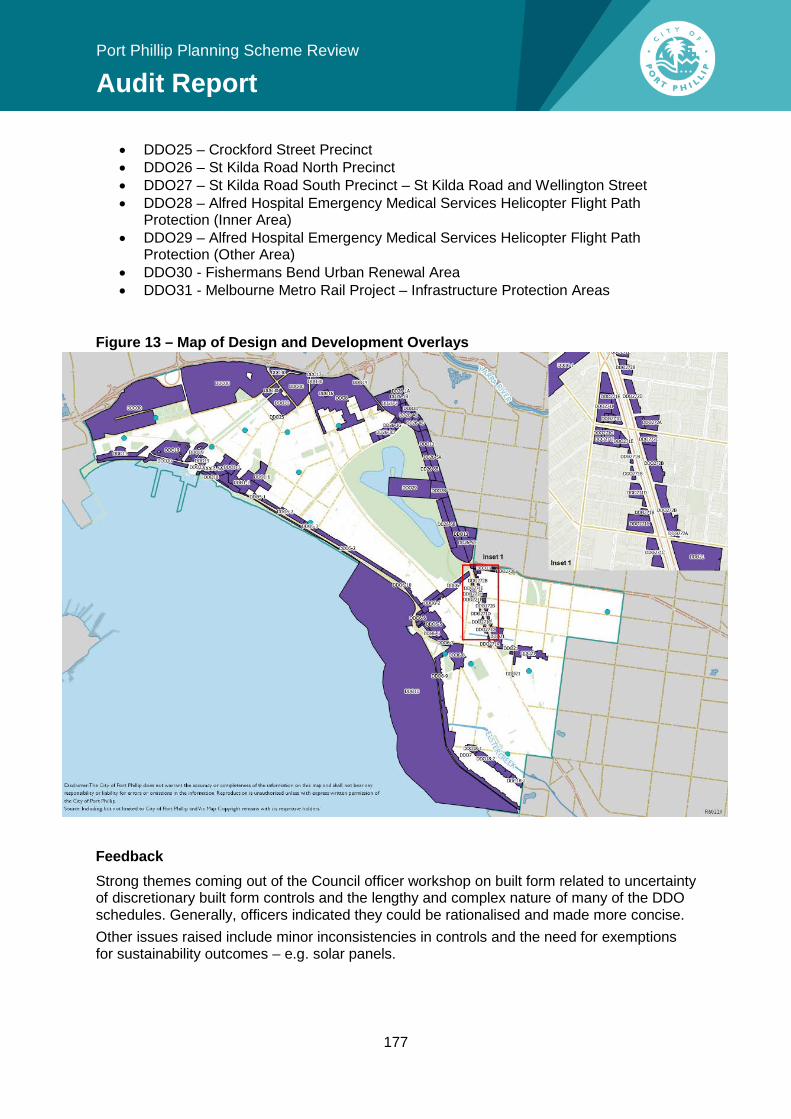
177
Port Phillip Planning Scheme Review
Audit Report
• DDO25 – Crockford Street Precinct • DDO26 – St Kilda Road North Precinct • DDO27 – St Kilda Road South Precinct – St Kilda Road and Wellington Street • DDO28 – Alfred Hospital Emergency Medical Services Helicopter Flight Path
Protection (Inner Area) • DDO29 – Alfred Hospital Emergency Medical Services Helicopter Flight Path
Protection (Other Area) • DDO30 - Fishermans Bend Urban Renewal Area • DDO31 - Melbourne Metro Rail Project – Infrastructure Protection Areas
Figure 13 – Map of Design and Development Overlays
Feedback Strong themes coming out of the Council officer workshop on built form related to uncertainty of discretionary built form controls and the lengthy and complex nature of many of the DDO schedules. Generally, officers indicated they could be rationalised and made more concise. Other issues raised include minor inconsistencies in controls and the need for exemptions for sustainability outcomes – e.g. solar panels.
Port Phillip Planning Scheme Review
Audit Report
There was also an identified need to review policy and DDOs that express overshadowing policies or controls to ensure a consistent approach across the foreshore (see section 11.5.3). A number of VCAT decisions provided feedback on the expression of building heights, with a clear preference for expression of building heights in metres (over storeys) to reduce confusion (see Appendix 4 – VCAT Analysis). There were also a number of occasions the Tribunal was critical of Council’s use of mandatory built form controls in Design and Development Overlays, where:
• mandatory controls can create inefficiencies and wasted opportunities in circumstances where a proposed development clearly meets the spirit of the control but fails to meet the letter of the law 45
• mandatory controls are so prescriptive, arbitrary and inflexible as to prevent reasonable development like a wind turbine to exceed the maximum height limit in DDO18 46.
Issues and Opportunities Reducing length and complexity There are many generic urban design requirements common to the majority of the DDO schedules, particularly those affecting activity centres. As a result, there is scope to relocate these universal design requirements to the MSS. This would enable the DDO schedules to better focus on place-specific built form and design elements. Refer to section 11.2 for further discussion around this. Overshadowing Review all existing overshadowing policy and controls to strengthen and provide a consistent city-wide approach for solar access to foreshore and public space, where possible – refer to section 11.5.3. Interaction with heritage areas Council officers identified an inconsistency and general lack of guidance on how the DDO interacts with a heritage areas. For example, some DDO schedules include a statement that where a site is affected by the Heritage Overlay, the provisions of that overlay take precedence. Some DDOs also require compliance with another part of the scheme, like Clause 22.04 Heritage Local Planning Policy. Any review should consider a more consistent approach. Accommodating relocated built form policies from dissolved LPPs There are a number of local planning policies that apply to local areas which have the potential to be dissolved, with content relocated to the MSS and appropriate DDOs – refer to section 12.2.1. Change to the format of DDO schedules The Minister for Planning recently amended the Ministerial Direction on the Form and Content of Planning Schemes to limit the number of objectives a DDO may have to a maximum of five to reduce the increasing complexity of schedules. The implications of this
45 170 Ormond Road Pty Ltd v Port Phillip CC & Ors (Correction) [2013] VCAT 988 (18 June 2013) 46 Eidelson v Port Phillip CC [2008] VCAT 1066 (19 June 2008)
179
Port Phillip Planning Scheme Review
Audit Report
will need to be considered, potentially impeding the ability for Council to conduct a policy-neutral review of some DDO schedules.
Recommendation 78: Consider a policy-neutral review of all Design and Development Overlays to improve clarity and consistency and relocate generic requirements to local policy.
Content of DDO schedules There are a number of specific DDO schedules that Council officers highlighted as potentially in need of a content review, given they are resulting in unintended or poor development outcomes.
DDO8 (South Melbourne Central) The South Melbourne Activity Centre Structure Plan and Urban Design Framework (undertaken in 2007) was translated into the Scheme in 2008, through MSS policy and a new DDO for South Melbourne Central area. The DDO8 reflects the implementation of the South Melbourne Central Structure Plan and Urban Design Framework (2007). DDO8 contains a detailed range of mandatory and discretionary provisions. The three aspects of the mandatory controls relate to:
• street wall heights • building setbacks (above street wall and upper level setbacks - multiple tiers) • other design requirements (street activation, glazing, ground floor level, articulation,
sunlight to streets and open space) The Planning Panel’s review of DDO8 (Amendment C52 Panel Report, December 2006), recommended removing mandatory building heights. However, upper level setbacks were considered justified to achieve a consistent streetscape and maintain a sense of openness and sky visibility. Officer feedback identified the need for a review of DDO8 to ensure detailed design requirements are achieving design objectives, given the following issues with implementation of the mandatory controls:
• some properties cannot develop above the street wall height due to mandatory requirements for large upper level setbacks, and the sites being too small to accommodate these (e.g. area 8-9a)
• in a few cases, a single street block has two areas applied to it (one to each half). A number of sites have consolidated since the DDO and now larger developments are having to address different mandatory requirements (street wall heights, upper level setbacks)
• poor built form outcomes (such as stepped ‘wedding cake’ style building designs) due to overshadowing and upper level setback requirements
• building proposals that exceed discretionary height limits exacerbate the ‘wedding cake’ building designs, as the higher the development, more tiered setbacks are required
• no height limits in some areas (e.g. area 8-1) may result in inappropriate building heights adjacent to heritage buildings
Port Phillip Planning Scheme Review
Audit Report
• clarify expression of discretionary building heights given the significant disparity in height. This is due to VCAT identifying confusion its interpretation (e.g. the maximum overall building height should not exceed 23.5 meters or 6 storeys, whichever is lesser). VCAT found:
“No party could explain definitively why there is both a metre and storey measure for height or why the measures have potential for significant disparity in height. Council referred to allowing for flexibility in use through higher floor to ceiling heights and Mr Sheppard thought it was to achieve improved ESD outcomes relating to daylight access.”
DDO6 (St Kilda Area) The DDO6 applies to the St Kilda Activity Centre and foreshore area which was last updated in 2005 by Amendment C43. A priority of Council over the next four years is to develop a strategic plan for the St Kilda precinct, including a strategy to revitalise Fitzroy Street (Outcome 5.1 of the Council Plan 2017-27). It is timely that a comprehensive review of the St Kilda Activity Centre take place – refer to section 10.1.2 (St Kilda Activity Centre).
DDO26 (St Kilda Road North Precinct) The built form controls to implement the St Kilda Road North Precinct Plan were introduced in June 2016. There are a number of issues with DDO26 that require clarification, relating to side and rear setbacks, setbacks to laneways, exceptions to mandatory requirements and location of pedestrian through-block links. In approving the Amendment, the Minister for Planning made some mandatory controls discretionary, without changing the way the requirements were worded resulting in some confusing discretionary ‘musts’. These non-mandatory requirements should be redrafted from ‘must’ to ‘should’ to clarify the control is discretionary. Council is currently progressing a review of the DDO requirements to iron out some of the current issues. Council is also undertaking further strategic work in the form of a Domain Precinct Plan to consider the implications of further growth in this precinct, including the policies of Plan Melbourne 2017-50 and the addition of the new Metro station ‘Domain’.
Recommendation 79: Review the Design and Development Overlays for South Melbourne Central Activity Centre (DDO8), St Kilda area (DDO6) and St Kilda Road North Precinct (DDO26) to ensure the built form requirements are achieving intended outcomes.
Incorporated Plan Overlay (IPO)
Application The Scheme applies the IPO1 to land bounded by Rouse Street, Esplanade East, Graham Street and Esplanade West in Port Melbourne. The purpose of the IPO1 is to facilitate the use and development of the land for residential purposes in accordance with an Incorporated Plan. In this case, it relates to the Development Concept Plan and Building Envelope Plan dated 22 October, 1996.
181
Port Phillip Planning Scheme Review
Audit Report
Opportunities The land covered by the overlay has now been developed in accordance with the incorporated document and this overlay should be removed.
Recommendation 80: Remove the redundant Incorporated Plan Overlay applying to Becton, Port Melbourne.
Development Plan Overlay (DPO)
Application The only schedule to the DPO is applied to the St Kilda Triangle site, which is the land bound by Jacka Boulevard, Cavell Street and The Esplanade, St Kilda.
Opportunities At some point, this may be replaced by a new suite of planning controls to implement the updated St Kilda Triangle Masterplan 2016.
Neighbourhood Character Overlay (NCO)
Application Five schedules to the NCO were introduced into the Scheme via Amendment C73 (2011) which implemented the planning framework for the residential component of Beacon Cove. The schedules were applied to the low rise residential area in Beacon Cove to control the form of future development to maintain the character of future development, and were prepared having regard to the reference document Beacon Cove Neighbourhood Guidelines, SJB Urban, 2010.
Opportunities The recent application of the new residential zones through Amendment C123 creates some overlap with the Neighbourhood Residential Zone (NRZ) given their shared purpose to ensure that development respects neighbourhood character. There is also some overlap with the Design and Development Overlay (DDO19) which provides design requirements for front fences in Beacon Cove. These controls could also be rationalised through a schedule to the NRZ. A review of the controls applying to Beacon Cove should be undertaken with a view to simplifying the suite of controls that apply to the properties, to remove any duplication that may exist and provide transparency to scheme users. Council may wish to expand the use of the NCO to preserve neighbourhood character for other areas within the municipality exhibiting distinct character elements. This should be explored as part of future work on reviewing Council’s Local Housing Strategy and/or undertaking a Neighbourhood Character study. See sections 11.2.4 (neighbourhood character) and 10.6.1 (housing strategy) for further discussion around this issue.
Port Phillip Planning Scheme Review
Audit Report
Land Management Overlays
Special Building Overlay (SBO)
Application A schedule to the SBO has been applied to land liable to flood in a 1 in 100 year event due to overland flow paths from the stormwater drainage system. It seeks to maintain the free passage of floodwaters, minimise flood damage. It applies to various parcels of land across the municipality, generally in low lying areas with proximity to drains and other waterbodies.
Opportunities The Scheme’s flood mapping extent (land covered by SBO) was recently updated in Amendment C111 in May 2016. The update was based on flood modelling by Melbourne Water. As its application is based on the most up-to-date information, there is no need to update the SBO maps at this time. However, the update did not take into consideration flooding as a result of the impacts of climate change (increased rainfall) or land that will be subject to coastal inundation in by 2100. There is an opportunity to review the maps in the future to accommodate flood modelling that incorporates increased rainfall as a result of climate change once the data is available.
Land Subject to Inundation Overlay (LSIO)
Application The LSIO is not currently used within the Scheme. The purpose of this overlay is to identify land in a flood storage or flood fringe area to ensure development addresses flooding.
Opportunities The recent amendment to Council’s flood maps through Amendment C111 (SBO maps) did not take into consideration flooding by coastal inundation as a result of climate change. There is the potential to apply this overlay to the municipality’s coastal areas - see section 11.3.2 (Coastal impacts of climate change) for further detail.
Other Overlays
Public Acquisition Overlay (PAO)
Application The PAO identifies land which is proposed to be acquired by a Minister, public authority or municipal council to ensure that any use or development won’t prejudice the purpose for which the land is to be acquired. The PAO currently applies to a number of wedges proposed to be acquired by VicRoads for road widening. It also applies to one residential house surrounded by a public reserve which is earmarked to be acquired for the purposes of public open space.
Opportunities This schedule can be utilised if and when the need arises. The schedule currently specifies PAO1 for open space, which no longer applies in map form. The schedule should be reformatted to reflect this.
183
Port Phillip Planning Scheme Review
Audit Report
Recommendation 81: Update the schedule to the Public Acquisition Overlay to reflect the maps.
Environmental Audit Overlay
Application The EAO is applied to land that is potentially contaminated and zoned to allow a sensitive use that could be significantly adversely affected by any contamination. The EAO applies to land across Port Phillip in residential, mixed use and commercial zones, to trigger the requirement for an environmental audit to be carried out prior to the commencement of a sensitive use (residential use, child care centre, pre-school centre, primary school) or construction or carrying out of buildings and works in association with a sensitive use commences.
Opportunities Once a Certificate of Environmental Audit is issued, or a Statement of Environmental Audit determines the site is suitable for a sensitive use, a permitted development/ land use can commence. The EAO requires regular review and Council is currently progressing an amendment to remove the EAO from a number of properties where a Certificate or Statement of Environmental Audit has been issued in accordance with Part IXD of the Environment Protection Act 1970.
Recommendation 82: Update the Environmental Audit Overlay maps to remove obsolete provisions.
Development Contributions Plan Overlay (DCPO)
Application An approved Development Contributions Plan (DCP) is implemented through the DCPO in the Scheme. Currently, the Scheme has two areas within a Development Contributions Plan Overlay – the Port Melbourne mixed use area DCP (streetscape works) and the Fishermans Bend Urban Renewal Area.
Opportunities Refer to section 11.6.5 (Physical infrastructure – development contributions) for further discussion on development contributions.
Parking Overlay (PO)
Application The Scheme currently has only utilised the parking overlay for the Fishermans Bend Urban Renewal Area.
Opportunities Refer to section 11.7.3 (sustainable car parking – parking overlay) for an analysis of this overlay and its opportunities.
Port Phillip Planning Scheme Review
Audit Report
12.4 Effectiveness of the specific provisions
12.4.1 Particular provisions
Public open space contribution schedule (Clause 52.01) The schedule to Clause 52.01 (Public Open Space Contribution and Subdivision) specifies the amount of contribution to the council a person who proposes to subdivide land must make. Currently the schedule lists 5% for all land in the municipality and 8% for Fishermans Bend Land. Refer to section 11.5.1 of this report which discusses potential updates to this schedule following the development of the new Public Space Strategy which is currently underway.
Easements, restrictions and reserves schedule (Clause 52.02) This schedule specifies land for which an easement or restriction may be removed or varied and how, under Section 23, 24 and 36 of the Subdivision Act 1998. No updates are required unless the need arises on a case-by-case basis.
Site specific exclusions schedule (Clause 52.03) The schedule to Clause 52.03 lists land for which the normal provisions of the scheme do not apply, and reference specific controls in an incorporating document corresponding to that land. A review of this schedule (and the incorporated documents at Claus 81.01 was a recommendation of the 2006 Audit, however this has not been implemented. The schedule will need to be reviewed to determine if any of the properties listed (and any associated incorporated document at the schedule to Clause 81.01) can be removed from the list. See Incorporated documents section below for the review recommendation.
Advertising signs (Clause 52.05) The purpose of this schedule is to list an area in which a major promotion sign is exempt from notice and decision requirements. Currently, Council has not identified the strategic need to utilise this schedule.
Native vegetation precinct plan schedule (Clause 52.16) The purpose of this schedule is to list any native vegetation precinct plans within a defined area. A native vegetation precinct plan sets out requirements for the protection and removal of native vegetation for a defined area. It is useful for areas with significant native vegetation proposed to undergo significant change. Council currently has no native vegetation precinct plans, nor any strategic need to utilise this schedule.
185
Port Phillip Planning Scheme Review
Audit Report
Native vegetation schedule (Clause 52.17) This schedule is used to specify areas in which the need for a permit to remove, destroy or lop native vegetation under Clause 52.17 is exempt. It may also specify weeds that are exempt from the same requirements. The native vegetation requirements are only triggered on properties over 0.4 hectares and the City has few of them. Accordingly, there is currently no identified need to use the schedule to streamline native vegetation removal permit requirements.
Licensed premises schedule (Clause 52.27) The purpose of this schedule is to exempt specific liquor licences from requiring a permit under Clause 52.27 for the land specified. Currently a number of ‘On Premises Licences’ are exempt for properties around Beacon Cove. It may also be used to specify land and a type of licence to be prohibited. Any review of this schedule should be included in the development of a licensed premises local planning policy identified in section 11.4.6.
Gaming schedule (Clause 52.28) The schedule to Clause 52.28 (Gaming) prohibits the installation or use of a gaming machine on land specified in the schedule to the clause. The schedule currently lists one shopping complex and 18 shopping centres, with property ranges specified. The properties apply to commercial zoned land. The Schedules to Clause 52.28 were not changed by Amendment C88 which updated the gaming policy in 2013. This means the centres have not been comprehensively reviewed since 1999 (Amendment VC5) when councils were offered the opportunity to nominate strip shopping centres and shopping complexes where gaming machines would be prohibited as part of the State-wide initiative. It is timely that a review take place to ensure the schedule applies to relevant land. There are a number of commercially zoned land parcels missing from the list, including in Mills Street, Middle Park and north of York Street, South Melbourne (which includes a Centrelink office). Consideration should be given to prohibiting all strip shopping centres which meets the definition within the head provision: As specified in Clause 52.28 (Gaming) a strip shopping centre is an area that meets all of the following requirements:
• zoned for commercial use • consists of at least two separate buildings on at least two separate and adjoining lots • is an area in which a significant proportion of the buildings are shops • is an area in which a significant proportion of the lots abut a road accessible to the
public generally. Updating this schedule would have the benefit of accommodating changes in zoning and land use over time, to capture they types of strip centres for which harm minimisation accessibility principles are intended to apply. It would also automatically capture any new commercial land that is established, without needing to wait until the next time the schedule is reviewed (e.g. within Fishermans Bend).
Port Phillip Planning Scheme Review
Audit Report
An update could also be made to specify any prohibition of gaming machines in shopping complexes (e.g. new internal shopping centres/malls) that do not meet the definition of a ‘shopping strip’ in the head provision.
Recommendation 83: Review the schedule to Clause 52.28 to update the list of shopping strips/centres in which new gaming machines should be prohibited.
Post boxes and dry stone walls schedule (Clause 52.37) The schedule to Clause 52.37 requires a permit for the removal of post boxes constructed before 1930 and dry stone walls constructed before 1940 on land specified in the schedule to the clause. Currently, there are none specified in the schedule. Feedback from Council’s heritage officer reveals there are no known dry stone walls within the City of Port Phillip. As a result, this schedule does not require updating.
Live music and entertainment noise schedule (Clause 52.43) Clause 52.43 was introduced into the VPP in September 2014 to respond to the increasing tensions between live music venues and medium and high-density residential developments. The provision requires that a new development, be it a new live music venue (LMV) or new residential development, incorporate appropriate noise attenuation measures to protect residents from adverse amenity impacts. This is called the ‘agent of change’ principle. It is intended that the provision protects both live music venues and sensitive uses. Port Phillip is increasingly seeing residential development within mixed-use precincts and activity centres, where licensed premises that incorporate some form of live music are often located. Feedback from Council officers suggests there is an increase in residential development in activity centres and therefore increased amenity expectations; affecting business and music venues. Council has the ability to utilise the schedule to Clause 52.43 to define conditions or limitations of the Clause for specific venues. For example, the Yarra Planning Scheme has nominated the Collingwood Arts Precincts as a ‘Live Music Venue’ that will be protected by the provision. This aligns with the Victorian Government’s intention to use the land for a creative hub / integrated arts precinct. Council has the ability to utilise this schedule if a need arises in the future. The management of noise from live music venues is also addressed by Clause 52.43.
12.4.2 General provisions
Administration and enforcement of this scheme (Clause 61.01) This schedule sets out the responsible authority for administering and enforcing the scheme, which is generally Port Phillip City Council. It also lists alternative responsible authorities for certain provisions under the scheme, including the Minister for Planning (e.g. for Albert Park Reserve, the Port Zone, the Melbourne Convention Centre and Fishermans Bend) and Metropolitan Planning Authority for development contributions in Fishermans Bend. This schedule does not require updating, however it is noted that Council is seeking to establish greater Responsible Authority status in the proposed GC81.
187
Port Phillip Planning Scheme Review
Audit Report
Area covered by the Scheme (Clause 61.02) This schedule sets out the area covered by the scheme. The area covered by the Scheme has not changed so no update is required.
Maps comprising part of the scheme schedule (Clause 61.03) This schedule sets out a list of planning scheme maps detailing zones and overlays across the municipality that make up part of the Port Phillip Planning Scheme. This schedule gets regularly updated by planning scheme amendments that make zone or overlay changes, however there is merit in regularly auditing the schedule to check that it accurately reflects the current scheme and to correct any anomalies that may have occurred.
Commencement of the Scheme (Clause 61.04) This schedule identifies the date at which the new format Port Phillip Planning Scheme commenced and accurately reflects the maps which makes up the planning scheme. It does not require updating.
Referral of permit applications under local provisions (Clause 66.04) This schedule lists referral requirements for certain types of planning permit applications under local provisions. This list is currently up-to-date. However, Council is advocating to the State Government to have referral authority status for applications in Fishermans Bend where the Minister for Planning is the Responsible Authority. This will be consistent with the referral authority status given to Melbourne City Council for similar applications in Fishermans Bend. It will also ensure Council will automatically be party to relevant VCAT proceedings.
Notice of permit applications under local provisions (Clause 66.06) This schedule lists notice requirements for certain types of planning permit applications under local provisions. There is an anomaly in the wording for the provision relating to Schedule 26 to Clause 43.02 (DDO26) that specifies the Clause for height exemptions (Clause 4.0), rather than the Clause for the mandatory height limits within the schedule (Clause 3). This is not significant, as the schedule to DDO26 identifies the correct notice procedure, but it should be corrected in the Review.
Recommendation 84: Review the schedule to Clause 66.06 to correct a minor anomaly.
12.4.3 Incorporated documents
Incorporated documents (Clause 81.01) A review of the incorporated documents listed in the schedule to Clause 81.01 (and the list of site specific exclusions at Clause 52.03) was a recommendation of the 2006 Audit and has not been implemented.
Port Phillip Planning Scheme Review
Audit Report
A preliminary review of incorporated documents listed in the schedule to Clause 81.01 revealed many comprise site specific exclusion controls for individual sites that have now been developed and can be removed from the Scheme. This will require further investigation and Council should review the permits for the properties with incorporated documents at the schedule to Clause 81.01 (Along with its corresponding control at the schedule to Clause 52.03) to determine whether they can be removed from the list.
Recommendation 85: Review and update the incorporated documents within the Port Phillip Planning Scheme for accuracy.
12.4.4 VicSmart planning assessment
Local VicSmart applications (Clause 94 and 95) Application VicSmart allows Council to ‘schedule in’ local classes of applications that are not specified at the state level. Port Phillip’s VicSmart schedules are currently blank. Council has a Fast Track Service to speed up the planning process for minor planning applications that are not eligible for VicSmart. These are confined to minor buildings and works that do not require advertising or external referrals. At the time of writing, very few Councils have taken advantage of the VicSmart local provisions. Of the Councils that have local VicSmart provisions, the following is an example of the types of applications that could benefit from the process:
• Use land to sell or consume liquor with a food and drink premises between certain hours (Greater Geelong)
• Construct a building or carry out works under a specific DDO schedule (Ballarat).
Feedback Council officers have identified a number of types of permit applications that may be suitable for the VicSmart process.
Opportunities There is an opportunity to introduce a greater range of more routine permit applications than what is provided under Council’s Fast Track Service that would benefit from the exemptions and process set out in the VicSmart process. For example, the schedule allows Council to establish a set of local criteria for applications under particular zones, overlays and particular provisions which, if met, would provide a faster and more efficient planning process. The provision provides for a 10 day permit process, pre-set information requirements and, provided applications meet certain requirements, exemption from notice and third party review (no advertising or objector appeal rights) and exemption from assessment against broader planning scheme objectives. The benefits of undertaking such a process include a reduced regulatory and administrative burden, including alleviating the pressure on planning resources and potential positive economic benefits from reducing the cost and timeframe associated with the planning permit process for more routine planning applications.
189
Port Phillip Planning Scheme Review
Audit Report
Smart Planning reforms to VicSmart The state government’s Smart Planning program is proposing to broaden the application of VicSmart by better integrating it into the VPP (structural changes) and evolving its operation to support more codified assessment pathways. This may assist simple common applications with multiple permit triggers (e.g. a small café in an existing high street shop). Council should liaise with the Department prior to implementing any outcomes of the Review. Recommendation 86: Explore the potential for Council to prescribe local classes of VicSmart applications to streamline simple planning applications.

191
Port Phillip Planning Scheme Review
Audit Report
13 Conclusion This Audit Report represents a comprehensive review of the Port Phillip Planning Scheme, as required by the Act. The Review has analysed the Scheme’s strategic performance to ensure it is current and relevant, clear and unambiguous and effective and efficient. Overall, the Port Phillip Planning Scheme is sound and most of its policy direction remains valid. However it has been some time since its last update in 2011. Since then, significant shifts in state and local planning policy and reformed controls have taken place. This includes the rezoning of the Fishermans Bend, the planning scheme zones reform and a new Metropolitan Strategy (Plan Melbourne 2017-50), all of which have implications for local policy. The City is facing unprecedented population growth and urban intensification which has implications for housing policy, access to open space, the evolution of our activity centres, pressure on heritage areas and employment precincts, increased amenity impacts and infrastructure that is at capacity. Council has undertaken significant strategic work in recent years in response. Going forward, there is a need to more holistically plan for and respond to the City’s growth. The Audit Report analysed data, policy and feedback on the performance of the Scheme and makes 86 recommendations to update or improve the Scheme, or carry out further strategic work. They range from minor updates, to more comprehensive reviews and development of new policy to addressing gaps in the Scheme and to create a clearer, more succinct planning scheme. A four-year implementation plan has been developed which will prioritise recommendations based on a needs and risk-based approach and considering realistic timing and resources to implement the reforms. The LPPF will be revised in a two-stage approach, with two main planning scheme amendments to be undertaken over a four year period. Some of the larger policy reviews will be undertaken and implemented separately, representing the continuous improvement of the Port Phillip Planning Scheme over the next four years.

193
Port Phillip Planning Scheme Review
Audit Report
14 List of recommendations
14.1.1 Recommendations to address potential gaps Recommendation 5: Develop a future vision and strategic framework to guide the role and function of the St Kilda Activity Centre (Fitzroy/Acland Streets). Recommendation 7: Carry out further strategic work to consider how to retain creative industries and urban manufacturers within the municipality, in partnership with the IMAP. Recommendation 8: Progress further strategic work in response to development opportunities for important tourist destinations such as Waterfront Place and the St Kilda Triangle. Recommendation 9: Create a city-wide spatial plan to:
• better define the City’s urban structure and character at both a city-wide and local level
• integrate spatial elements of key strategies such as the Integrated Transport Strategy and Public Spaces Strategy
• protect key features of the City’s urban structure and character. Recommendation 11: Review Port Phillip’s neighbourhood character policy to better articulate Council’s preferred vision. Recommendation 14: Update the thematic history in the Port Phillip Heritage Review to addressing any heritage gaps. Recommendation 15: Review heritage overlay precincts HO6 (part St Kilda/East St Kilda), (HO5 St Kilda Hill), HO7 (parts Elwood, Balaclava, Ripponlea) and HO8 (Elwood) and the Montague Precinct. Recommendation 17: Undertake a review of all properties identified as ‘Contributory Heritage Places outside of the Heritage Overlay’ to determine whether any warrant inclusion within the Heritage Overlay. Recommendation 18: Undertake a city-wide social heritage assessment. Recommendation 20: Carry out a municipal Aboriginal cultural heritage study/strategy. Recommendation 23: Apply the Environmental Significance Overlay to sites of biological significance to raise their profile and minimise the loss of significant vegetation. Recommendation 26: Add policy support in the MSS for new development to consider the impact of a changing climate.

Port Phillip Planning Scheme Review
Audit Report
Recommendation 30: Explore options to require additional canopy trees/green infrastructure with new development. Recommendation 35: Promote the concept of universal accessibility for people of all ages and abilities and age and child friendly cities in the MSS. Recommendation 36: Promote urban agriculture and food-sensitive urban design in the MSS. Recommendation 38: Develop a licensed premises policy to guide the appropriate location and design of licensed premises to ensure they make a positive contribution commensurate to the role of each activity centre and to effectively manage amenity impacts. Recommendation 47: Consider undertaking a broader sunlight to public spaces analysis for the wider municipality. Recommendation 53: Update the MSS to include policy support for accessible housing that is suitable for people of all ages and abilities. Recommendation 54: Review options to fund the infrastructure required to support a growing population. Recommendation 57: Consider using the Parking Overlay to require more sustainable car parking rates (including maximum rates) for new office and residential development in select high-growth locations close to public transport, shops and services. Recommendation 58: Investigate the potential to secure development contributions for sustainable car parking rates to fund active transport initiatives. Recommendation 62: Incorporate an application requirement for high-density development that requires Waste Management Plans to be consistent with Council’s Waste Management Guidelines, once developed. Recommendation 63: Update design policy for higher density residential development to encourage the provision of space that will accommodate on-site loading where development is on a busy road. Recommendation 70: Comprehensively review the heritage policy to strengthen and broaden its scope to respond to a broader range of development types, including commercial and industrial properties. Recommendation 71: Revise the Heritage Local Planning Policy to provide greater guidance for ESD facilities on heritage places. Recommendation 86: Explore the potential for Council to prescribe local classes of VicSmart applications to streamline simple planning applications.
195
Port Phillip Planning Scheme Review
Audit Report
14.1.2 Recommendations to improve policy Recommendation 1: Undertake an employment land strategy to identify the City’s employment needs and trends and determine whether a more proactive approach to retaining employment land is required. Recommendation 3: Update and strengthen activity centre policy in the MSS to reinforce the role and function and future direction of activity centres. Recommendation 4: Develop a new Activity Centres Strategy and Implementation Plan to inform detailed land use policy and structure plans. Recommendation 6: Strengthen policy to manage potential amenity conflicts in mixed use environments and activity centres. Recommendation 10: Review urban design policy to clarify ‘design excellence’. Recommendation 12: Consider the need to retain the ‘Contributory Heritage Places outside of the Heritage Overlay’ designation for properties not suitable for a heritage overlay and alternative ways to protect neighbourhood character attributes of residential areas. Recommendation 19: Update policy in the MSS relating to aboriginal cultural heritage to:
• better reflect Council’s obligation to identify, assess and document places of historic, cultural and social significance
• support development that reflects Aboriginal values and urban design perspectives.
Recommendation 25: Investigate ways to increase impervious surfaces in new development and facilitate onsite stormwater detention to become a more water sensitive City. Recommendation 29: Update the MSS policy on significant trees to promote the enhancement of landscape character. Recommendation 32: Update the MSS to reflect best practice integrated water management objectives and strategies, including the efficient and sustainable use of water, minimising risk of flooding and protecting the ecological health of waterways. Recommendation 33: Work with Melbourne Water and other Councils within the Elster Creek catchment on a whole-of-catchment approach to flood prevention, including exploring the use of planning mechanisms to deliver appropriate built form outcomes and infrastructure upgrades. Recommendation 34:
Port Phillip Planning Scheme Review
Audit Report
Strengthen local policies on liveable neighbourhoods and places within the MSS to raise the profile of planning policies that contribute to community health and wellbeing and place-making. Recommendation 37: Expand community infrastructure policy in the MSS to address co-location, clustering, adaptable spaces and design guidance for mixed use developments. Recommendation 39: Revise the social impact assessment policy within the MSS to refine the trigger for when it’s required. Recommendation 41: Review public open space policy and controls following completion of the Public Space Strategy to address public open space deficit and facilitate smarter, multi-use and adaptable spaces. Recommendation 42: Assess the potential for implementing revised public open space contributions in the Scheme. Recommendation 48: Prepare a revised Housing Strategy to:
• take into consideration current factors and demand influencing housing provision • update housing policy to account for the new residential zones and Fishermans
Bend • consider using the new zones to more effectively direct housing growth and
diversity while respecting heritage and neighbourhood character values • consider the review areas that were not addressed by Amendment C123 • continue to monitor and understand housing trends in the municipality.
Recommendation 49: Clarify housing residential growth area definitions within the MSS based on an updated Housing Strategy. Recommendation 50: Ensure best practice urban renewal planning and sustainable development outcomes for Fishermans Bend and holistically integrate this into the MSS. Recommendation 51: Strengthen affordable housing policy in the MSS by reflecting the directions of state policy and In Our Backyard - Growing Affordable Housing in Port Phillip 2015-2025. Recommendation 52: Update the Scheme to strengthen housing diversity policy by specifying the desired outcome and including policy support for alternative forms of housing. Recommendation 56: Strengthen policies in the MSS on sustainable transport to promote the concept of placemaking in our streets. Recommendation 59: Consider ways to improve policies relating to car parking, including:
• facilitating flexible car parking design • guidance to improve Green Travel Plans
197
Port Phillip Planning Scheme Review
Audit Report
• supporting car share facilities in on-street locations, or where demand is demonstrated.
Recommendation 60: Support more and better designed bicycle spaces and facilities within private development, particularly where car parking is reduced. Recommendation 76: Retain and update stormwater policy to broaden its application and on-site detention criteria.
14.1.3 Recommendations to update policy Recommendation 2: Update land use policies within the MSS to align with the new commercial zones. Recommendation 13: Progressively update the Port Phillip Design Manual 2000, starting with the areas subject to the greatest change and development pressure. Recommendation 16: Progressively review older individual heritage citations to ensure they meet the current criteria for establishing heritage significance. Recommendation 43: Review the Sport and Recreation Strategy 2015 – 2024 and reflect current key issues and recreation trends and incorporate relevant strategies into the MSS where appropriate. Recommendation 44: Reflect the Activating Laneways Strategy 2011 in the MSS to highlight the multi-functional role of laneways as unique public spaces. Recommendation 45: Update foreshore policy to reflect relevant policies of the updated Foreshore Management Plan 2012 and be consistent with the Victorian Coastal Strategy 2014. Recommendation 46: Review existing overshadowing policy to aim for greater consistency across the City. Recommendation 55: Update the MSS to reflect the Integrated Transport Strategy, once developed. Recommendation 61: Update the MSS to include waste management requirements for multi-unit and high-density development, which maximise recycling and diversion from land fill. Recommendation 65: Review all reference documents to ensure they are still current, relevant and useful. Recommendation 67: Retain and update local policy on non-residential uses in the residential zones to reflect permit discretions in the reformed zones. Recommendation 69: Retain and update local policy on caretaker’s houses in industrial and business zones to reflect the zone reforms.
Port Phillip Planning Scheme Review
Audit Report
Recommendation 72: Retain and update subdivision local policy to ensure they remain relevant and clear. Recommendation 75: Update and strengthen local advertising policy on billboards, major promotional signs, electronic signs and acceptable locations. Recommendation 77: Introduce planning permit exemptions for properties in the Heritage Overlay for low-impact buildings and works. Recommendation 79: Review the Design and Development Overlays for South Melbourne Central Activity Centre (DDO8), St Kilda area (DDO6) and St Kilda Road North Precinct (DDO26) to ensure the built form requirements are achieving intended outcomes. Recommendation 83: Review the schedule to Clause 52.28 to update the list of shopping strips/centres in which new gaming machines should be prohibited. Recommendation 74: Retain Gaming local policy in its current form.
14.1.4 Recommendations to correct anomalies Recommendation 80: Remove the redundant Incorporated Plan Overlay applying to Becton, Port Melbourne. Recommendation 68: Retain and update policy on backpacker’s lodges to correct minor anomalies. Recommendation 81: Update the schedule to the Public Acquisition Overlay to reflect the maps. Recommendation 82: Update the Environmental Audit Overlay maps to remove obsolete provisions. Recommendation 84: Review the schedule to Clause 66.06 to correct a minor anomaly. Recommendation 85: Review and update the incorporated documents within the Port Phillip Planning Scheme for accuracy.
14.1.5 Recommendations to improve efficiency and processes
Recommendation 21: Consider training and/or developing guidelines to inform Council officers of Aboriginal cultural heritage sites and processes. Recommendation 24: Explore the benefit of using the planning scheme provisions over local laws to protect significant trees across the municipality.
199
Port Phillip Planning Scheme Review
Audit Report
Recommendation 28: Review Council’s process in assessing green infrastructure proposals to identify if Council can facilitate better outcomes. Recommendation 40: Develop social impact assessment guidelines to set out processes, acceptable scope and methodology and to clarify the types of development where it’s required. Recommendation 64: The MSS will need to be restructured to more closely reflect the themes of the State Planning Policy Framework to improve clarity and reduce duplication. Council should take the opportunity to work with the state government to implement the proposed integrated planning policy as part of the Smart Planning reforms. Recommendation 66: Relocate the area-based Local Planning Policies to the MSS and other relevant parts of the Planning Scheme. Recommendation 73: Revise and strengthen local urban design policy to consolidate common urban design policies throughout the scheme (including DDOs) and consider any gaps not addressed by the new better apartment standards. Recommendation 78: Consider a policy-neutral review of all Design and Development Overlays to improve clarity and consistency and relocate generic requirements to local policy.
14.1.6 Recommendations to continue advocacy Recommendation 22: Continue to advocate to the Minister for Planning for a permanent Environmentally Sustainable Development Local Planning Policy, or an equivalent state-wide provision which maintains and builds upon the existing local policy and improve advice on how applicants can meet the best-practice ESD objectives of this policy. Recommendation 27: Continue to advocate to the State Government for stronger planning mechanisms that will allow Council to influence sustainable development outcomes and respond to climate change hazards. Recommendation 31: Continue to advocate for new tools to identify coastal areas vulnerable to climate change, including coastal inundation and storm surges.

201
Port Phillip Planning Scheme Review
Audit Report
15 Implementation This Audit Report represents a comprehensive review of the Port Phillip Planning Scheme, making 85 recommendations. These range from minor corrections to significant pieces of strategic work and policy review. See Figure 14 – Stages of the Planning Scheme Review.
Continuous improvement approach The majority of the recommendations to amend the LPPF will be implemented in two main ‘Planning Scheme Review Amendments’ to be undertaken over a four-year period. Other recommendations that don’t fit within the scope of these amendments will be undertaken separately, including some of the larger policy reviews like the Housing Strategy and Public Spaces Strategy. These will be implemented through a holistic rewrite of the MSS to align with the Council Plan, the SPPF and address current planning issues and policies. Policy development will be limited to those Council strategies that have been completed by mid-2018. The development of policies that require significant strategic work will be undertaken separately or through the second Review amendment which will be undertaken in later years. Council will liaise with the State Government on their proposed development of an integrated planning policy framework, which will have implications for the MSS rewrite. Council may be able to rewrite the MSS into the new integrated state and local planning policy framework due to be finalised by the State Government in mid-2018.
Implementation Plan An Implementation Plan will be developed to provide an indicative four-year work program to phase the implementation of the recommendations and further strategic work, representing a continuous improvement of the Scheme over the next four-years. The recommendations will be prioritised based on their alignment to the Council Plan and a project priority matrix. This will recognise the ease at which some recommendations can be implemented, compared to others. As the LPPF establishes a strategic basis for decision making for Council’s planning decisions, any major changes must be justified either through existing policies, or carrying out further strategic work to establish an evidence base to introduce new policy or controls. The timeframes will also factor in the capacity of Council to implement the reforms and a change in circumstances or priority. A quarterly reporting framework will be established to inform Councillors of the progress of the Review and to monitor the progress of the Plan. For an overview of the Planning Scheme Review implementation, see Appendix 6.
State policy and advocacy The State Government is currently progressing a significant work program of policy and structural reform to implement Plan Melbourne 2017-50 and the Smart Planning Program. This may result in changes to some recommendations, which will be reflected in the reporting framework. A number of recommendations rely on further clarity, policy direction or reform by the State Government to address policy issues or implement Plan Melbourne strategies. The Review will need to be informed by further discussions with State Government agencies to clarify the scope or intention of these policies and how they can be implemented at a local level.
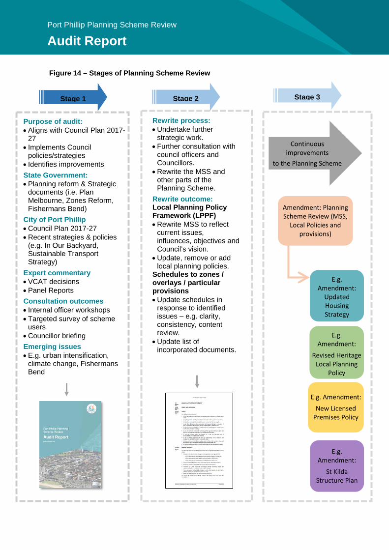
Port Phillip Planning Scheme Review
Audit Report
Figure 14 – Stages of Planning Scheme Review
Purpose of audit: • Aligns with Council Plan 2017-
27 • Implements Council
policies/strategies • Identifies improvements State Government: • Planning reform & Strategic
documents (i.e. Plan Melbourne, Zones Reform, Fishermans Bend)
City of Port Phillip • Council Plan 2017-27 • Recent strategies & policies
(e.g. In Our Backyard, Sustainable Transport Strategy)
Expert commentary • VCAT decisions • Panel Reports Consultation outcomes • Internal officer workshops • Targeted survey of scheme
users • Councillor briefing Emerging issues • E.g. urban intensification,
climate change, Fishermans Bend
Rewrite process: • Undertake further
strategic work. • Further consultation with
council officers and Councillors.
• Rewrite the MSS and other parts of the Planning Scheme.
Rewrite outcome: Local Planning Policy Framework (LPPF) • Rewrite MSS to reflect
current issues, influences, objectives and Council’s vision.
• Update, remove or add local planning policies.
Schedules to zones / overlays / particular provisions • Update schedules in
response to identified issues – e.g. clarity, consistency, content review.
• Update list of incorporated documents.
E.g. Amendment:
Updated Housing Strategy
Amendment: Planning Scheme Review (MSS,
Local Policies and provisions)
Continuous improvements
to the Planning Scheme
E.g. Amendment: New Licensed
Premises Policy
Stage 1 Stage 2 Stage 3
E.g. Amendment:
Revised Heritage Local Planning
Policy
E.g. Amendment:
St Kilda Structure Plan
203
Port Phillip Planning Scheme Review
Audit Report
16 Appendices Appendix 1 – Statutory Planning Improvement Program Appendix 2 – What is the Port Phillip Planning Scheme? Appendix 3 – Outstanding recommendations Appendix 4 – Planning panels analysis Appendix 5 – VCAT analysis Appendix 6 – Key policies Appendix 7 – Planning scheme users survey report

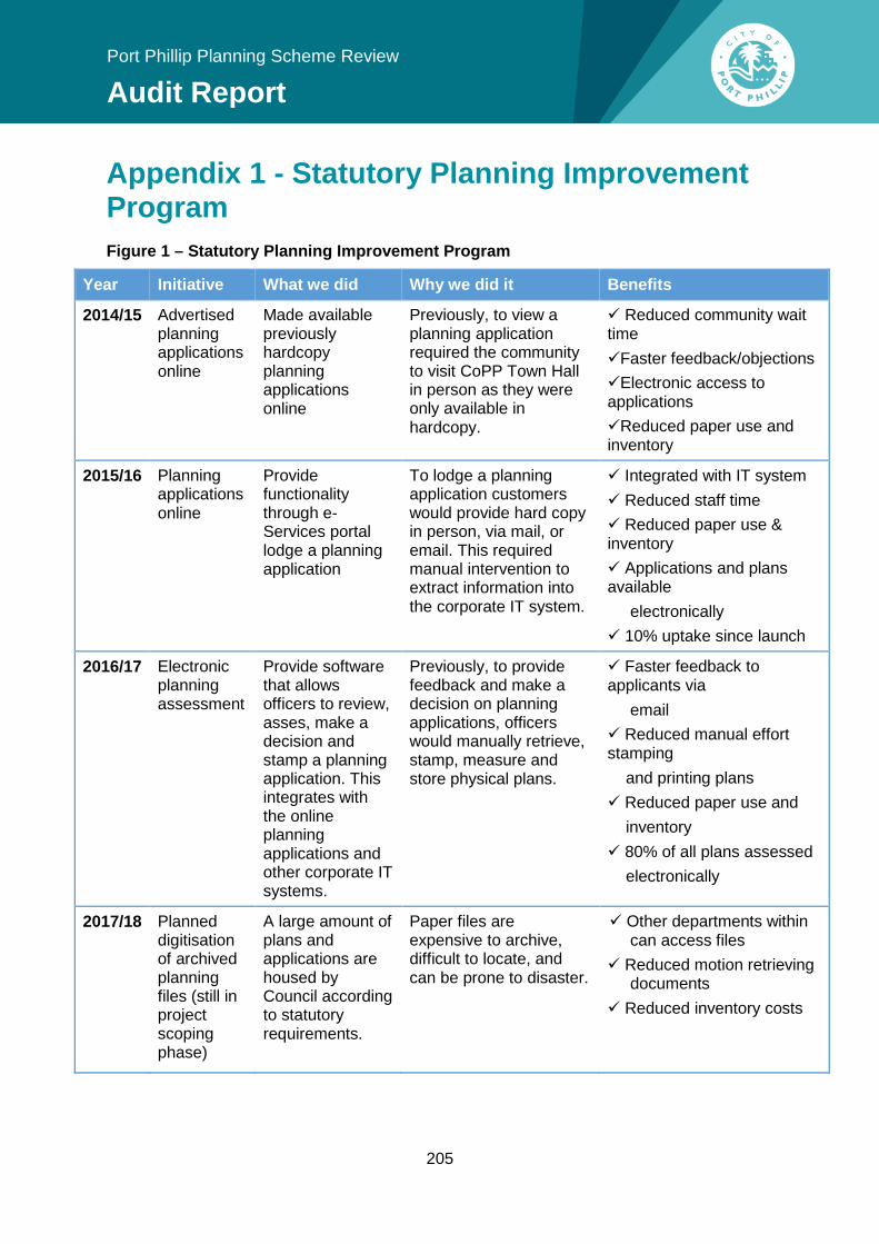
205
Port Phillip Planning Scheme Review
Audit Report
Appendix 1 - Statutory Planning Improvement Program Figure 1 – Statutory Planning Improvement Program
Year Initiative What we did Why we did it Benefits
2014/15 Advertised planning applications online
Made available previously hardcopy planning applications online
Previously, to view a planning application required the community to visit CoPP Town Hall in person as they were only available in hardcopy.
Reduced community wait time Faster feedback/objections Electronic access to applications Reduced paper use and inventory
2015/16 Planning applications online
Provide functionality through e-Services portal lodge a planning application
To lodge a planning application customers would provide hard copy in person, via mail, or email. This required manual intervention to extract information into the corporate IT system.
Integrated with IT system Reduced staff time Reduced paper use & inventory Applications and plans available electronically 10% uptake since launch
2016/17 Electronic planning assessment
Provide software that allows officers to review, asses, make a decision and stamp a planning application. This integrates with the online planning applications and other corporate IT systems.
Previously, to provide feedback and make a decision on planning applications, officers would manually retrieve, stamp, measure and store physical plans.
Faster feedback to applicants via email Reduced manual effort stamping and printing plans Reduced paper use and inventory 80% of all plans assessed electronically
2017/18 Planned digitisation of archived planning files (still in project scoping phase)
A large amount of plans and applications are housed by Council according to statutory requirements.
Paper files are expensive to archive, difficult to locate, and can be prone to disaster.
Other departments within can access files
Reduced motion retrieving documents
Reduced inventory costs
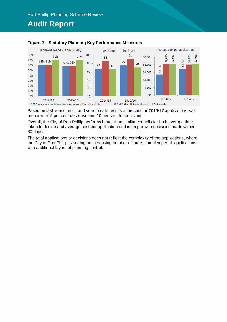
Port Phillip Planning Scheme Review
Audit Report
Figure 2 – Statutory Planning Key Performance Measures
Based on last year’s result and year to date results a forecast for 2016/17 applications was prepared at 5 per cent decrease and 10 per cent for decisions. Overall, the City of Port Phillip performs better than similar councils for both average time taken to decide and average cost per application and is on par with decisions made within 60 days. The total applications or decisions does not reflect the complexity of the applications, where the City of Port Phillip is seeing an increasing number of large, complex permit applications with additional layers of planning control.
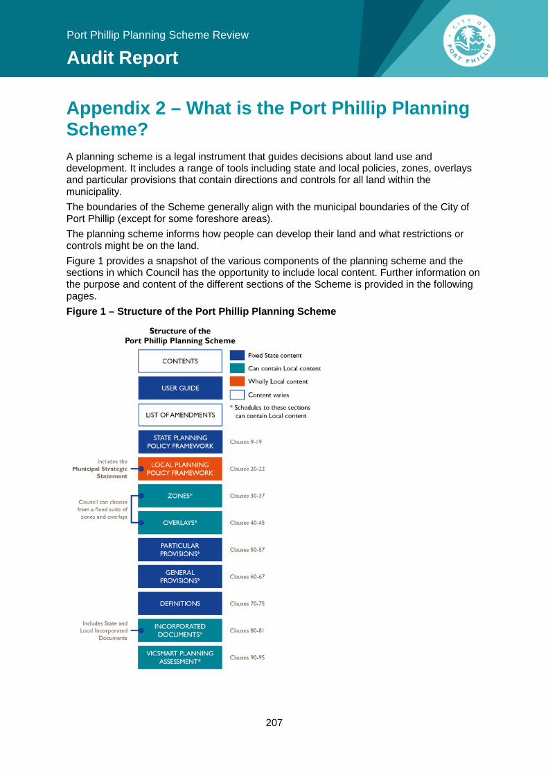
207
Port Phillip Planning Scheme Review
Audit Report
Appendix 2 – What is the Port Phillip Planning Scheme? A planning scheme is a legal instrument that guides decisions about land use and development. It includes a range of tools including state and local policies, zones, overlays and particular provisions that contain directions and controls for all land within the municipality. The boundaries of the Scheme generally align with the municipal boundaries of the City of Port Phillip (except for some foreshore areas). The planning scheme informs how people can develop their land and what restrictions or controls might be on the land. Figure 1 provides a snapshot of the various components of the planning scheme and the sections in which Council has the opportunity to include local content. Further information on the purpose and content of the different sections of the Scheme is provided in the following pages. Figure 1 – Structure of the Port Phillip Planning Scheme
Port Phillip Planning Scheme Review
Audit Report
State Planning Policy Framework State policies are contained in the State Planning Policy Framework (SPPF). They are the same in every planning scheme in Victoria and must be taken into account in land use and development decisions. The SPPF comprises general principles for land use and development in Victoria. It is divided into the following nine key areas, where it provides specific strategies for:
• Plan Melbourne (the Metropolitan Strategy) • Settlement • Environmental and Landscape Values • Environmental Risks • Natural Resource Management • Built Environment and Heritage • Housing • Economic Development • Transport • Infrastructure.
Local Planning Policy Framework The purpose of the LPPF is to demonstrate how broader State planning policies will be achieved or implemented in a local context. It contains a number of components; The MSS at Clause 21, and LPP at Clause 22, and local schedules to zones, overlays, general and particular provisions.
• The MSS provides a statement of the key strategic planning, land use and development objectives for the municipality, and sets out the strategies and actions for achieving those objectives.
• A MSS should support and implement the State Planning Policy Framework, which together with the MSS, provides the strategic basis for application of planning controls.
• Local planning policies are policy statements about specific types of land uses or developments, or circumstances (e.g. development in heritage areas).
Zones, overlays, particular and general provisions • Zones reflect the primary character of land, such as residential, commercial, rural or
other; and indicate the type of use which may be appropriate in that zone. • Overlay controls operate in addition to the zone controls and ensure that important
aspects of the land are recognised (e.g. heritage places and flood prone areas). • Particular provisions are additional planning provisions for a range of specific type of
uses and developments (e.g. advertising signs, bicycle facilities and car parking). • General provisions are operational requirements which are consistent across the Stat
(e.g. existing use rights, administrative provisions, ancillary activities and referral of applications).
• Incorporated Documents comprise documents that are essential to the administration or enforcement of the planning scheme.
• The VicSmart planning assessment process outlines classes of applications that are eligible for the streamlined VicSmart assessment process.
209
Port Phillip Planning Scheme Review
Audit Report
Appendix 3 – Outstanding recommendations Table 1 – Outstanding recommendations from the 2006 Planning Scheme Review
Rec 2006 Review Recommendation
Topic/Reference Doc
Status Implication for 2017 Review
12 Amend minor zoning anomalies at 99 Carlisle Street and 100 Blessington Street, and 31 Prentice Street, St Kilda.
Zones Zoning anomalies have not been amended to date.
Add the zoning anomalies identified in the 2006 Review to the fix-up list. Maintain a database of anomalies and updates to carry out with regular ‘fix-up’ planning scheme amendments.
15 Redraft SUZ1 to reflect the Incorporated Document “St Kilda Sea Baths” and delete this document from Clause 81.
Particular Provision
St Kilda Sea Baths is still an incorporated document in the Scheme. Current best practice is not to have detailed, site specific zone schedules.
Review all incorporated documents to determine if they are still relevant, or could be incorporated into the scheme in a more effective and transparent manner.
16 Seek legal advice as to whether Luna Park can be deleted from Clause 81 and, if it can, redraft the incorporated document into Schedule 2 to the SUZ.
Particular Provision
Luna Park is still an incorporated document in the Scheme. Current best practice is not to have detailed, site specific zone schedules.
As above.
17 Review the permits for each of the following properties to determine whether they can be deleted from the schedule to Clause 52.03 – Specific Sites and Inclusions (and consequentially from the schedule to Clause 81). Legal advice may be required. • 360 – 370 St Kilda
Road, Melbourne • 414 – 416 St Kilda
Road and 418 St Kilda Road
• 582 – 584 St Kilda Road, Melbourne
• 167 Fitzroy Street, St Kilda
Particular Provision
All properties except for 4 Princes Street are still listed in the schedule. A review was undertaken and some were retained for transparency or continued approvals. This should be reviewed again.
Review the permits for the properties listed in the schedule to Clause 52.03 (and any associated incorporated document at the schedule to Clause 81.01) to determine whether they can be removed from the list.
Port Phillip Planning Scheme Review
Audit Report
Rec 2006 Review Recommendation
Topic/Reference Doc
Status Implication for 2017 Review
• 29 Fitzroy Street, St Kilda
• 89 Fitzroy Street St Kilda
• 14 – 16 The Esplanade, St Kilda
• 12 Acland Street, St Kilda
• 132 – 134 Bank Street and 223 – 227 Moray Street, South Melbourne
• 315 – 317 Beaconsfield Pde and 109 – 111 Park Street, St Kilda
• 400 – 410 City Road, 1-48 Cecil Street and 127 – 135 Whiteman Street, South Melbourne
• 4 Princes Street, St Kilda
• Bertie Street, Port Melbourne (Part 61 Bertie Street, Port Melbourne 2001)
63 Review the Urban Iconography Strategy 2002 and identify icons within the strategy that have not been translated into the scheme via a Heritage amendment. Note these icons as requiring Heritage Overlays to be applied under “Future Work”.
Urban Iconography Study (2002)
Clause 21.05 (Built Form) mentions Port Phillip’s icons contribute towards a ‘sense of place’. Strategy 1.9 of Clause 21.05-1 (Heritage) is to maintain the visual prominence of icons. Strategy 6.6.41 (St Kilda Foreshore Area – in Clause 21.06 Neighbourhoods) is to retain and reinforce the unique cultural heritage of the area through ensuring new uses and development complement and enhance establish iconic buildings, spaces and attractions. The Study is not a reference document within the MSS, but it is in Clause 22.09 (St Kilda Foreshore Area Policy) and DDO21.
Consider the Iconography Strategy as part of the Heritage Program.
211
Port Phillip Planning Scheme Review
Audit Report
Rec 2006 Review Recommendation
Topic/Reference Doc
Status Implication for 2017 Review
78 Review the LPPF (specifically Clause 21.05-4 and Clauses 22.05/22.06) to reflect the following action: “to develop criteria for child friendly buildings and developments in Port Phillip”. Recognise the need to undertake further work, in the form of a Playground Strategy, to meet the goal of improving child development, health and wellbeing and specifically, maximising opportunities for play.
Municipal Early Years Plan – Creating a Child Friendly Port Phillip
General community facilities strategies were included in the MSS. Playgrounds are described as part of physical infrastructure in Clause 21.05-4 which includes a number of objectives and strategies relating to meeting the needs of current and future generations. Play Space Strategy 2011 Creating a Child Friendly Port Phillip 2012-15 Councillors adopted the Victorian Child Friendly Cities and Communities Charter in 2015
Consider ways in which the MSS can better reflect Council’s commitment to becoming a child-friendly and age-friendly city and reflect adopted Council strategies.
79 Update the MSS to reflect the objective of increasing opportunities for physical activity and developing supportive environments.
ISEPICH Community Health Plan 2004-2006
The MSS has indirect policies relating to creating an integrated sustainable transport network supporting cycling and walking in terms of sustainability, but doesn’t mention health and wellbeing benefits.
Consider ways to better reflect the health and wellbeing benefits of active transport and open space and facilities for recreation in the MSS.
93 Identify the preparation of a Lanes policy under “Future Work” in the MSS.
Policy gaps identified by Council, planners and VCAT
Activating Laneways Strategy July 2011 was adopted by Council on 22 August 2011 which was after the last Planning Scheme Review was implemented in C62. The MSS has policy on (Clause 21.05-2 – Urban Structure and Character) protecting and enhancing the function of laneways.
Review the Activating Laneways Strategy July 2011 to incorporate relevant content into the MSS to provide further guidance on use of our laneways, and include it as a reference document.
95 Incorporate relevant principles of the nightlife policy framework into the MSS. Identify the investigation as to the preparation of a local policy relating to licensed premises operating after 1am and providing
Policy gaps identified by Council, planners and VCAT
Clause 21.04-6 (Tourism and the Arts) includes two strategies relating to minimising the impact of late night entertainment uses. Clause 21.04-8 (Social Impact Assessments): Strategy 1.1 requires preparation of a Social Impact Assessment in association with applications for new Taverns,
This action was superseded by the 1am lockout laws and freeze on late night licenses. Review licensed premises policy to determine if the current policy in the
Port Phillip Planning Scheme Review
Audit Report
Rec 2006 Review Recommendation
Topic/Reference Doc
Status Implication for 2017 Review
amplified music as “Future Work” in the MSS.
Nightclubs and Hotels, or where an increase in the patron numbers to such Licensed Venues is proposed.
MSS is effective and a LPP is warranted.
98 Identify the preparation of Neighbourhood Character Frameworks for areas not covered by the HO or a DDO in “future work” in the MSS. Update the MSS to reflect areas where consistency of character is important, and where change will be encouraged, where known. Amendments to Clause 22.04 - Heritage
Policy gaps identified by Council, planners and VCAT
The MSS at C62 introduced a new section in Clause 21.05-2 (Urban Structure and Character) to strengthen neighbourhood character objectives and strategies. Future work was not identified in the MSS in C62. No broader review of the Design Manual for areas not covered by a HO or DDO has been undertaken, however new character statements were added for the Carlisle Street and Bay Street Activity Centres when their structure plans were prepared in 2009 and 2014, respectively.
Progressively update Phillip Design Manual 2000, starting with the areas subject to the greatest change and development pressure.
99 • Review the Clause 22 Heritage Policy to clarify the definition of feasible reuse.
• Review Clause 22.04 – Heritage Policy to address policy clarifications and gaps as identified by the planners.
• Identify the review of the application of the Heritage Policy under “future work” in the MSS.
• Identify the preparation of heritage policy for non residential buildings under “Future Work” in the MSS.
Policy gaps identified by Council, planners and VCAT
In Amendment C62 the policy was: o reworded to ensure
consistency with the practice note and provide more specific guidance
o restructured to improve the flow of the policy for applicants and decision makers
o amended to add an objective encouraging retention, reuse and recycling of heritage buildings
o amended to introduce policy in regard to laneways, kerbs and channels and street furniture.
The addition of policy in relation to lane ways, kerbing and channelling is a minor change to the policy. The change implements the Council’s Heritage Kerbs, Channels and Laneways Guideline (2006). The mention of ‘feasible reuse’ in relation to demolition of
Undertake a comprehensive review of Clause 22.04 Heritage Policy as part of the broader Heritage Program.
213
Port Phillip Planning Scheme Review
Audit Report
Rec 2006 Review Recommendation
Topic/Reference Doc
Status Implication for 2017 Review
heritage buildings has been removed from Clause 22.04. No heritage policy has been prepared for non-residential buildings. No refinements to the performance measures were included. The extent of the heritage overlay has been subject to a continuous improvement initiative, reviewing particular areas over time.
102 Identify the preparation of a Development Contributions Plan for the municipality as future work in the MSS.
Policy gaps identified by Council, planners and VCAT
Future work was not part of the MSS structure from the last rewrite. No municipal-wide DCP has been prepared.
Outstanding. In the medium-long term, Council should review the options available to fund the infrastructure needed to support its growing population.
103 Review the Yarra Planning Scheme and Melbourne Planning Scheme accessibility framework and incorporate a similar framework into the Port Phillip MSS. Prepare a local policy for accessible buildings for incorporation in the Local Policy planning Framework.
Policy gaps identified by Council, planners and VCAT
The MSS identifies that future housing must respond to the need for housing which is accessible and adaptable for people with disabilities and older persons, as the housing market is not adequately providing for these types. However at the time, Council was not permitted by the Minister to introduce any more prescriptive requirement.
Include policy in the MSS supporting the provision of flexible and accessible housing that is suitable for all ages and abilities. The better apartments standards include accessibility requirements. Advocate for more prescriptive requirements for smaller developments.
104 Identify the preparation of appropriate planning frameworks under Future Work for the following places:
• Acland Street, St Kilda
• Fitzroy Street, St Kilda
• Brighton Road
Policy gaps identified by Council, planners and VCAT
Identification of future work was not includes in the MSS in C62. No structure plan has been prepared for Acland/Fitzroy Street St Kilda Activity Centre. St Kilda Road North and St Kilda Road South have had structure plans prepared.
Outstanding. Prepare a structure plan for the St Kilda Major Activity Centre.

Port Phillip Planning Scheme Review
Audit Report
Rec 2006 Review Recommendation
Topic/Reference Doc
Status Implication for 2017 Review
• St Kilda Junction • Armstrong
Road/Victoria Street Shopping Centre
• Brigport Street Shopping Centre
• Central Avenue, Garden City
The others are NACs and further planning work will be undertaken as the need arises.
215
Port Phillip Planning Scheme Review
Audit Report
Appendix 4 - Planning panels analysis An amendment to the Port Phillip Planning Scheme may be referred to an independent Planning Panel to hear any unresolved community submissions and to recommend whether an amendment should proceed, with or without changes. Planning Panels are established under the Planning and Environment Act 1987. The Panel assesses a proposed planning scheme amendment by considering submissions, conducting hearings and preparing reports. Planning Panels are only advisors and make recommendations. The Act requires Council to formally consider the Panel’s report and recommendations, and determine whether to adopt the amendment with or without changes. The findings of the Panel can provide expert advice and lessons to Council about its approach to addressing particular planning issues, its drafting of planning provisions and controls and in recommending a best practice approach. Since the last audit of the Port Phillip Planning Scheme in 2006, 18 Amendments have had a Panel Report published (at the time of writing). Overall, the independent Panel Reports generally supported the objectives of these planning scheme amendments, either as exhibited or subject to changes as recommended by the final Panel report. The amendments varied in their scope from a site specific heritage review, medium to large heritage precinct reviews, structure plan implementation and design reviews (DDOs) and the previous Planning Scheme Review. Key findings are examined in themes below.
Mandatory and discretionary built form controls Since the last audit of the Port Phillip Planning Scheme, there have been five amendments to the Port Phillip Planning Scheme that have sought to apply mandatory or discretionary heights controls (St Kilda Road South – C122, South Melbourne Central – C52, Bay Street - C103, St Kilda Road North - C107, 1-7 Waterfront Place - C104, Ormond Road - C57). Key findings include:
• Planning Panels often supported the strategic work of Council in developing design guidelines, but questioned their translation into planning controls by debating the ratio of prescriptive versus mandatory controls within the framework.
• In cases with a very strong rationale for mandatory built form controls (e.g. to protect significant heritage values, or where there was a clear need for transition in scale) the Panel supported Council’s use of mandatory built form controls.
• However more often than not, they cautioned against a ‘heavy handed’ approach to mandatory requirements and recommended a more flexible approach (i.e. discretionary controls) or an increase in allowable heights, particularly in commercial areas.
• Reasons given included: o the need for a more balanced approach to juggling protection of
neighbourhood character with supporting growth in appropriate locations; and o Maintaining flexibility to support good design outcomes and lot size diversity.
• In general, Panel reports tended to favour a mix of discretionary and mandatory built form controls (e.g. street wall heights or setbacks of upper floor levels) without placing an absolute limit on the development potential of sites.
Port Phillip Planning Scheme Review
Audit Report
Amendment C122 Panel Report – St Kilda Road South Precinct (June 2017) Amendment C122 implements the St Kilda Road South Land Use and Design Framework. While the Panel supported the overall objectives of the Framework, their overall view is that the precinct has a strategic role to support growth and intensification:
“… the [planning authority’s] emphasis on managing ‘development pressure’ has led to restrictive built form requirements that do not recognise either the reality of recent development at greater scale or optimise the opportunity presented for urban renewal.”
The Panel recommended significantly increasing heights of discretionary building heights at the Junction, St Kilda Hill and at key intersections (by between 3-8 storeys). It also recommended increasing discretionary building heights by 1-2 storeys along the western side of St Kilda Road. The Panel stated that generally, the Amendment was balanced in its proposed use of mandatory controls where building heights are mainly discretionary except for Wellington Street and around the Presbyterian Church. However, in practice it did not support the application of mandatory building heights (proposed in Wellington Street and in the vicinity of the Church). However, it did support mandatory setbacks to protect view lines to the church, and a mandatory street wall height on the eastern side of St Kilda Road to reinforce the heritage elements of the streetscape. In Council’s response to the Panel Report, it varied many of the Panel’s recommended changes and maintained some of the mandatory controls (e.g. on Wellington Street and around the Church).
Amendment C52 Panel Report – South Melbourne Central (December 2006) Amendment C52 implemented the City of Port Phillip’s Structure Plan and Urban Design Framework for the South Melbourne Central Major Activity Centre. The Panel analysed the role of mandatory provisions in planning scheme, and found that mandatory controls are the exception to the norm, with a preference for detailed objectives and performance measures rather than prescriptive standards.
“In particular, the Panel wishes to reiterate the comments that, simply because a discretion exists in the planning controls, this does not mean that a departure from the nominated building height should, or will, be supported.”
On the basis of its analysis, the Panel found support for a mandatory regime for the street wall height and the upper level setbacks but it did not endorse a mandatory regime for absolute height, as it lacked strategic justification within the structure plan. The Panel made it clear that in recommending a discretionary height regime, they do not anticipate that much (if any) variation will be given to the maximum height.
Amendments C57 Panel Reports Parts 1 & 2: Ormond Road Design Guidelines (July 2007 & June 2008) Amendment C57 implemented the Ormond Road Urban Design Guidelines (2007). Overall, the Panel supported mandatory height and some setback controls in the precinct, however recommended increasing the height. The Panel found the benefit of mandatory controls in providing certainty for developers and the community outweighs the benefits of discretion for a few select sites. The Panel supported mandatory height controls in this precinct given the Ormond Road area was under redevelopment pressure. The Panel noted inappropriate developments of up to
217
Port Phillip Planning Scheme Review
Audit Report
five storeys (approved by VCAT) were changing the desirable scale of the area and could be used as benchmarks:
“We accept that, in the circumstances of the particular urban character of this area and its development pressures, the application of certain mandatory rather than merely preferred or discretionary design requirements is appropriate, including specification of maximum overall building heights.”
However, the Panel found the proposed controls limiting, and in need of increased heights and exemptions for further flexibility. Other key findings in relation to mandatory controls for Amendment C57 include: Removing “illogical” height controls for the Residential Precinct 2 in close proximity to the activity centre with existing height diversity. Raising commercial building heights to accommodate commercial floor levels and the SBO raised floor level requirements. Making the front & side setback requirements mandatory, given the importance of generous setbacks in this residential area, and that they be landscaped. Making discretionary other proposed mandatory controls relating to zero building setbacks, verandah and canopy effects, visual interaction with the street, street wall articulation and neighbouring amenity for flexibility. Total invisibility of the upper level in the commercial areas is excessive, as it should allow visibility of a small extent, particularly for oblique views. Amendment C52 was split to re-exhibit the proposed changes in Residential Precinct 2. The second Panel generally supported the proposed Part 2 changes, however reiterated the findings of the first Panel in recommending a slight rise in the mandatory maximum front wall height to provide design flexibility on top of accommodating the SBO raised floor levels.
C103 Panel Report: Bay Street Structure Plan implementation (June 2014) The amendment implemented the Bay Street Structure Plan. The Panel’s overall recommendation was that Amendment C103 to the Port Phillip Planning Scheme be adopted, subject to minor wording changes, excluding specific properties and deleting amenity standards. The proposed DDO25 comprised mandatory street wall heights and setbacks of upper floor levels from the front and rear boundaries, but a discretionary overall height. In discussing the use of mandatory street wall height and upper floor setback controls the Panel noted: ‘Panel accepts that Council has achieved successful built form outcomes through the use of mandatory elements such as mandatory street wall heights in DDO1 at the southern end of Bay Street. In these cases, Council has been careful to apply mandatory controls to the most critical elements of the built form to achieve a human scale at street level’ and that the Panel did not see strong arguments to depart from the approach that has been successful in managing the area to date. Further, the Panel noted: ‘This proposed redrafting of DDO25 with the mandatory provision of street wall heights and setbacks of upper floor levels from the front and rear boundaries, but not overall height remove debate about key development features required to fully implement the aspirations of the Structure Plan without placing an absolute limit on the development potential of the site.’
Port Phillip Planning Scheme Review
Audit Report
C104 Panel Report: 1-7 Waterfront Place, Port Melbourne (February 2014) This amendment sought to facilitate the renewal of a strategic development site at 1-7 Waterfront Place, Port Melbourne by introducing a suite of planning controls for the land, including mandatory height controls. The Panel’s overall recommendation was that Amendment C104 be adopted, subject to changes to the proposed development controls. In regards to use of mandatory controls over discretionary provisions, the Panel stated: “Imposing arbitrary requirements such as height limits would unnecessarily constrain good design outcomes. Instead, a high quality design outcome should be sought for this strategic redevelopment site through a combination of mandatory and discretionary provisions’ The Panel commended the strategic work in developing the Guidelines, but queried whether they should be translated literally (mandatory) or in a less prescriptive manner. The Panel found there were exceptional circumstances surrounding the subject site to warrant some mandatory provisions. This view was based on the site’s sensitive interface to the north, to the historic station and in regards to overshadowing of the beach. The Panel found that a human scale would be best achieved with a mandatory street wall height, however the height and envelope of the buildings should be determined by a rigorous design analysis and response driven by overshadowing objectives (discretionary controls). Regarding the use of mandatory height controls to prevent overshadowing of the foreshore the Panel stated that shadow diagrams and design responses were useful in that they provided Panel with the ‘ability to view the shadow consequences of so many optional design responses, from low rise up to 19 storeys with many varying building locations and also both equinox and solstice outcomes.’ The Panel concluded that mandatory height provisions should dictate the perimeter, street wall parts of the building and that the height of the internal portions should be driven by shadowing provisions. Council responded by undertaking additional urban design analysis and modelling of overshadowing impacts. Following completion and review of the detailed urban design analysis Council determined to not accept all of the Panel’s recommendations. Council submitted the revised amendment which was gazetted with the Minister supporting Council’s position on mandatory height controls and overshadowing of the beach.
C107 Panel Report: St Kilda Road North Precinct Review (May 2015) The Amendment implemented the St Kilda Road North Precinct Plan. The Panel’s overall view was that the discretionary provisions, applied together with the extensive design objectives in the DDO, provide a robust framework in which to assess applications. The Panel expressed strong support for the fundamental ‘urban design’ vision and character ‘key design elements which underpin the amendment’. These reflect important principles in relation to building heights, and the scale relationship between precincts and interface areas in particular protecting the Shrine, overshadowing, garden setbacks etc. The Panel shared Council’s concern about the protection of the boulevard character of St Kilda Road and stepping development down from St Kilda Road to Queens Road, however it found that a similar approach was not required for Kings Way. The Panel found that mandatory tower separation distance provision was not warranted or practical and discretionary side and rear setbacks were appropriate. Council disagreed with Panel’s recommendations on a number of occasions as it would result in less prescriptive controls for the Precinct than proposed by the exhibited
219
Port Phillip Planning Scheme Review
Audit Report
amendment, through making the majority of the design requirements discretionary rather than mandatory. In approving the amendment, the Minister made some mandatory provisions discretionary, including podium setbacks and tower separation.
C83 Priority Development Panel – 400-430 City Road, Southbank (December, 2009) The Amendment was part of a combined permit and amendment application for the City Road wedge in Southbank, seeking to amend the DDO8 to accommodate a large mixed-use development at the request of the proponent. A Priority Development Panel (PDP) was requested by the Minister to appraise the concept and give advice in relation to appropriate controls. The PDP dismissed Council’s objection to amend the DDO to vary the mandatory 10m setback of podium to accommodate proposed design’s setback of 3.5-8m:
“The PDP agrees that the proposed approach represents a more appropriate design outcome than would be achieved by strict interpretation of the mandatory controls, and agrees that DD08 should be amended to clarify the wording of the setback requirements, as suggested by Council.”
Heritage There were seven amendments that went to Panel that considered heritage matters, since the last Planning Scheme Review – Amendments C143, C122, C132, C117, C103, C89, C68. Key findings include:
• In all but one case, the Panel supported the strategic justification and methodology for heritage amendments.
• In a number of cases, Planning Panels queried the level of heritage significance attributed to certain properties and the area used for the comparative analysis.
• Clause 22.04 Heritage Local Planning Policy doesn’t provide for industrial buildings and the type of growth envisaged in urban renewal and high growth areas.
• Best practice includes undertaking community consultation when preparing heritage studies.
• Update thematic history in the Port Phillip Heritage Review sections of that history are of sufficient importance to justify the preservation of individual places and precincts.
Amendment C143 Panel Report: Heritage Overlay HO472 (September 2017) The Amendment implements the recommendations of the Fishermans Bend Heritage Study (2013) by applying the Heritage Overlay (HO472) to two properties in Port Melbourne (split from Amendment C117). Council applied a heritage overlay to the entire complex at 19 Salmon Street. The Citation attributes levels of significance (primary and secondary) within the site, and had recommendations for redevelopment based on the significance, i.e. retain all primary elements, and adapt secondary elements. The landowner submitted that only the art deco / corner entry building should be in the overlay, and that an overlay applied to the whole site is inconsistent with the Fishermans bend framework that promotes significant redevelopment.

Port Phillip Planning Scheme Review
Audit Report
The Panel recommended that the heritage overlay be reduced to the ‘primary significant’ buildings only. The Panel considered the 1955 extensions (‘Secondary significance’ in the Citation) to be of low heritage significance and not worthy of the Heritage Overlay. The Panel concluded that while it is generally standard practice to apply the Heritage Overlay to all of the parcel of land, on larger sites and in the context of strategic policy support to facilitate significant redevelopment, that the extent of the Heritage Overlay should relate only to the extent of land necessary to protect significant heritage values. The Panel also noted the tension between Clause 22.04 (Heritage Policy) demolition policy and the citation, which recommends a less restrictive approach to demolition. They also noted a tension between the policy’s built form guidance and the scale of development envisaged by DDO30 in the Fishermans Bend Urban Renewal Area: “In areas where redevelopment at significant scale is envisaged, a policy of ‘concealment’ of new development of land within the Heritage Overlay, as envisaged by the Clause 22.04 policy, will not necessarily strike the right balance. The Policy seems more suited to low scale residential heritage places or precincts than areas identified for intensive redevelopment.”
Amendment C117 Panel Report: Fishermans Bend (September 2016) The Amendment implements the recommendations of the Fishermans Bend Heritage Study (2013) to introduce heritage controls to a number of properties in Fishermans Bend, including placing sites in a Heritage Overlay. For other sites, which are already in a Heritage Overlay, the amendment updated citations, heritage gradings and statements of significance. The Panel for Amendment C117 made various changes and amendments to the exhibited heritage citations including making minor revisions and corrections through to deleting / removing citations from the amendment. The Panel recognised that the amendment was an important step in protecting important heritage places and planning for change within the Fishermans Bend Urban Renewal Area, which is poised for substantial strategic redevelopment. It also found the Amendment was supported by and implements the relevant sections of the state and local planning policy framework, was of sound methodology and generally well founded and strategically justified, subject to addressing the specific issues. The Panel recommended some fundamental changes including removing sites west of Smith Street from the HO, retaining three properties in the precinct HO4 (over individual an HO) and abandoning the proposed heritage overlay for some properties within the extended area of HO442. The Panel acknowledged that those buildings are of heritage significance but considered the application of HO442 (which covers Albert Park residential area) inappropriate as they are unrelated to the historical development of Albert Park. The sites west of Smith Street were not recommended for inclusion in the HO as the significance had not been demonstrated, as they had no historical association with the significant places. Concerning community consultation the Panel noted that one of the limitations of the study was that property owners were not consulted while the study was being prepared. The Panel stated that it considers that it is best practice to undertake community consultation in preparing heritage studies.
221
Port Phillip Planning Scheme Review
Audit Report
The Panel also recommended Council assess the “former Montague slum neighbourhood” for potential heritage significance as a potential precinct, a series of individual buildings/infrastructure items or serial listing, noting Amendment C117 did not address the wider Montague Precinct. Part of the Amendment was split for two properties (see Amendment C143) due to notification issues.
Amendment C54 Panel Report: Elwood Heritage Review (August 2006) Implemented the findings and recommendations of the Elwood Heritage Review 2005 by amending the schedule and maps to the Heritage Overlay and making changes to the Port Phillip Heritage Review. In handing down its report the Panel expressed concern in relation to a number of matters relating to the rigour with which the study had been conducted:
‘the lack of clearly defined assessment criteria, an absence of any clearly defined thresholds of local heritage significance and reliance on the Elwood locality as a basis for the comparative assessments’.
The Panel recommended that the various statements of significance in the Elwood Heritage Review should be reviewed, with a view to placing them on a more rigorous foundation, including a clear statement of the definition of each criterion. The Panel recommended that any future heritage studies for the City of Port Phillip should include, as part of the thematic history, statements as to what sections of that history are of sufficient importance to justify the preservation of individual places and precincts, and what criteria should be adopted to identify appropriate places for these important themes.
Local Planning Policy Framework Other Panels considered various amendments to the Local Planning Policy Framework on a number of topics, including the MSS rewrite, environmentally sustainable development and a SBO Review. Key findings include:
• Sustainable development is most efficiently assessed at the planning stage to achieve optimum ESD outcome;
• There is scope to reduce the length of the Local Planning Policy Framework without changing the intent of the policies;
• A Coastal Hazard Vulnerability Assessment for the region encompassing Port Phillip Bay should inform a planning tool to deal with coastal hazards and inundation associated with sea level rise;
• The MSS and DDO are the better VPP tools to use than a local planning policy, to implement the South Melbourne Central Structure Plan, providing greater simplicity, transparency and certainty.
Amendment C97 - Environmentally Efficient Design Local Policies (April 2014) For Amendment C97, the Minister appointed an Advisory Committee to hear submissions in response to a number of Council amendments that sought to introduce a local planning policy on built form sustainability; and to advise on the broader applicability and suitability of a local planning policy to require sustainability to be considered at the planning stage rather than the building stage.
Port Phillip Planning Scheme Review
Audit Report
Amendment C97 was co-exhibited with five other Councils and introduced a new policy at Clause 22.13- Environmentally Sustainable Development with objectives for new development to achieve best practice in environmentally sustainable development. The Committee concluded that sustainable development has had long history in planning; and that the issue has evolved to the point where many Councils are seeking to advance sustainable outcomes. It considered that, in principle, a State-wide approach was the best way to facilitate an increased focus on sustainability, however in the interim the Committee supported the amendments. Regarding the use of the Planning Scheme to guide policy, the Panel found that:
‘There is a strong legislative and policy framework that supports the need for sustainable development and which recognises that both planning and building have a significant role to play in achieving it’
And to achieve sustainability in planning, it should be undertaken using the most efficient mechanisms to minimise cost to consumers and industry – which can be achieved through the implementation of the amendments, and will enhance the role and a statutory obligation for planning to advance sustainability. Regarding the potential for the building systems to be the appropriate legislative tool, the Panel found that although there is a clear need for an integrated planning and building approach to achieve sustainable outcomes planning is best suited to dealing with the ‘big picture’ upfront issues, and building is best suited to managing the detailed aspects. The Panel also found that involvement of planning at the initial site planning stage enables the orientation, internal layouts and site development to be dealt with in a manner that assists at the building approval stage in achieving the best design outcome. The overall Panel recommendation was to approve Amendment C97 to the Port Phillip Planning Scheme generally as exhibited with minor changes to the wording to rename the policy to Environmentally Sustainable Development.
Amendment C62 – Revised Local Planning Policy Framework (November 2010) Amendment C62 updated the Municipal Strategic Statement to reflect the Council Plan and strategies, deleted several existing local policies and introduced four new policies. The Panel broadly supported the exhibited amendment, with the some minor changes. The Panel found that the proposed MSS and Local Planning Policies support and implement relevant aspects of the State Planning Policy Framework, that the policies have a clear and logical structure and assist the reader in understanding what the objectives are and how they will be achieved. The Panel was however critical of the drafting of the LPPF:
“While the Panel acknowledges that, at a length of over 120 pages, the revised Local Planning Policy Framework reflects the complexity and diversity of the City of Port Phillip, the Panel suggests that there may be some scope to reduce this length without any substantive change to its intent.”
In relation to the proposal to include a mandatory 5% public open space contribution, the Panel concluded that there is sound strategic support for the policy. The Open Space Strategy and Inner Regional Housing Statement demonstrate strategic support for a mandatory contribution, as did information provided by Council on the growing population, reducing provision of private open space and increasing density of development. The Panel recommended a number of minor changes to the amendment.
223
Port Phillip Planning Scheme Review
Audit Report
Amendment C111 - Panel Report: Review of the SBO (September 2015) This amendment updated the maps that identify land subject to the Special Building Overlay, removing some properties from the overlay and adding others. The SBO identifies land in urban areas liable to inundation by overland flows from the drainage system. The Panel found that, overall, the Amendment implements relevant sections of State and Local Planning Policy Framework, and has been prepared in accordance with the relevant Planning Practice Notes and Ministerial Directions’. The Panel considered the methodology that produced the overlay maps was sufficiently accurate to apply the SBO. Regarding submissions that queried why climate change had not been considered, or factored into the models the Panel found:
‘It would be premature to include the effects of sea level rise in the current Amendment and it is accepted that a Coastal Hazard Vulnerability Assessment for the central region (encompassing Port Phillip Bay) is a necessary precursor to the development of a planning tool to deal with coastal hazards and inundation associated with sea level rise’ In regards to submissions raising issues that the SBO would affect the value of their land, the Panel found that ‘there is a long held view in case law that property devaluation is not a valid planning consideration’ and ‘the impact on insurance is not a matter that should affect the imposition of the SBO through the planning scheme’.
C103 Panel Report: Bay Street Structure Plan implementation (June 2014) The amendment implemented the Bay Street Structure Plan. The Panel’s overall recommendation was that Amendment C103 to the Port Phillip Planning Scheme be adopted, subject to minor modifications and that Council take the Panel’s views on the proposed local planning policy into account. The exhibited amendment sought to introduce Clause 22.11 South Melbourne Central Policy into the MSS. The view of the Panel is that the policy is essentially a strategy and not a policy in the contexts of new format schemes, nothing that the content would fit in the MSS and a modified DDO.
The “Policy Basis” is really just “strategy” which the Panel believes should be collapsed into the MSS. The initial “Policy Objectives” at Clause 22.11 are the overarching objectives for the area. The Panel believes that their place is also within the MSS (and some in the DDO) under the heading “Objectives”. The actual “Policy” which then follows at Clause 22.11 is not so much a policy but a strategy based on ensuring that new development in the area will implement the SMSP.
For simplicity, transparency and greater certainty, the Panel believes that the objectives, detail and decision guidelines in the exhibited local policy should be redistributed into the MSS and the DDO.

225
Port Phillip Planning Scheme Review
Audit Report
Appendix 5 - VCAT analysis The purpose of the Victorian Civil and Administrative Tribunal (VCAT) analysis is to examine how the Tribunal has interpreted Council’s local policies, with a view to identifying where policies may or may not be working well, and whether there are any significant gaps in the Port Phillip Planning Scheme. VCAT reviewed Council decisions on planning permit applications, but also reviewed cases that weren’t decided in time, applications to amend permit and requests to extend the expiry date of planning permits.
Overview of VCAT decisions This analysis has chosen a sample review period from the 1 January 2013 to 7 September 2017 (nearly 5 years) which follows the gazettal of Amendment C62 47 which introduced Council’s last Planning Scheme Review. During this period there were 224 review proceedings conducted at the Tribunal. Of those cases:
• Council’s decision was affirmed on 59 occasions (or 26% of all instances), set aside on 87 occasions (or 39% of all instances) and varied on 69 occasions (30% of all instances).
• The largest portion (34%) were for an appeal by objectors (section 82 of the Act), followed by an appeal against a failure to decide within the prescribed timeframe (30%, section 79 of the Act), an appeal against a refusal (24%, and section 77 of the Act) and an appeal against conditions (9%, and section 80 of the Act).
• The majority (68%) involved land within the Residential 1 Zone (or General Residential Zone 1 following July 2014), the majority of which are covered by the Heritage Overlay.
The key issues to appear in decisions reviewed by VCAT, in order of frequency of appearance, are:
• Off-site amenity impacts (164 cases) • Neighbourhood character (86 cases) • Parking (79 cases) • Heritage (71 cases) • Built form – height (59 cases) • Built form – scale, bulk, overdevelopment (57 cases) • Internal amenity (37 cases) • Building design (20 cases) • Traffic and Transport (19 cases) • Streetscape - fences, landscaping, street trees (15 cases)
47 Amendment C62 to the Port Phillip Planning Scheme – Gazetted 27 June 2011
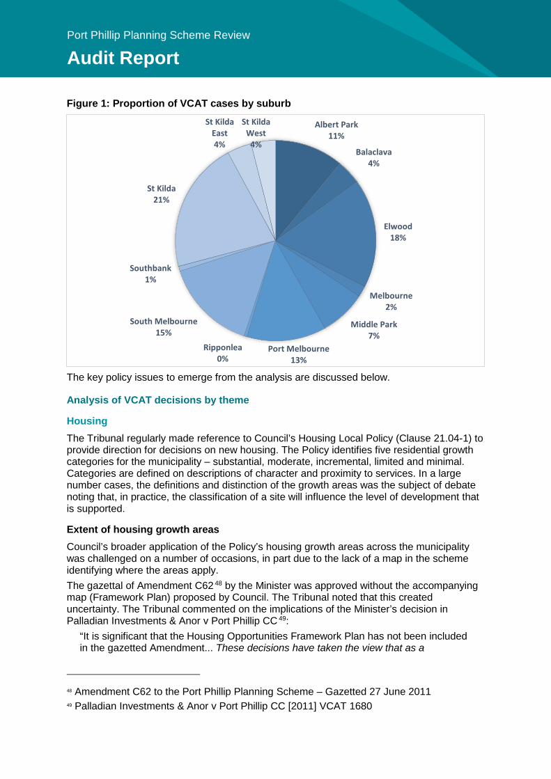
Port Phillip Planning Scheme Review
Audit Report
Figure 1: Proportion of VCAT cases by suburb
The key policy issues to emerge from the analysis are discussed below.
Analysis of VCAT decisions by theme
Housing The Tribunal regularly made reference to Council’s Housing Local Policy (Clause 21.04-1) to provide direction for decisions on new housing. The Policy identifies five residential growth categories for the municipality – substantial, moderate, incremental, limited and minimal. Categories are defined on descriptions of character and proximity to services. In a large number cases, the definitions and distinction of the growth areas was the subject of debate noting that, in practice, the classification of a site will influence the level of development that is supported.
Extent of housing growth areas Council’s broader application of the Policy’s housing growth areas across the municipality was challenged on a number of occasions, in part due to the lack of a map in the scheme identifying where the areas apply. The gazettal of Amendment C62 48 by the Minister was approved without the accompanying map (Framework Plan) proposed by Council. The Tribunal noted that this created uncertainty. The Tribunal commented on the implications of the Minister’s decision in Palladian Investments & Anor v Port Phillip CC 49:
“It is significant that the Housing Opportunities Framework Plan has not been included in the gazetted Amendment... These decisions have taken the view that as a
48 Amendment C62 to the Port Phillip Planning Scheme – Gazetted 27 June 2011 49 Palladian Investments & Anor v Port Phillip CC [2011] VCAT 1680
Albert Park11%
Balaclava4%
Elwood18%
Melbourne2%
Middle Park7%
Port Melbourne13%
Ripponlea0%
South Melbourne15%
Southbank1%
St Kilda21%
St Kilda East4%
St Kilda West
4%
227
Port Phillip Planning Scheme Review
Audit Report
consequence of the removal of the Framework Plan, a site’s inclusion in one or the other growth areas is a matter about which a judgement needs to be made, based on the criteria included in the planning scheme.”
The lack of an accompanying map in the Scheme has placed more emphasis on the wording contained within the policy definitions and provisions to provide clarity. Given the wording of the housing growth areas weren’t drafted to be read without the Framework Plan, they have created some confusion.
Directing medium density housing Further, the Tribunal considered there to be conflict between State Policy and Council’s Housing Policy in directing medium density housing. The State Planning Policy Framework (SPPF) at Clause 16.01-2 seeks to ‘encourage higher density housing development on sites that are well located in relation to jobs, services and public transport’. However Council’s Housing Policy identifies some sites with those characteristics as being contained within a ‘Limited Growth Area’, where medium density is expressly ‘not encouraged’. This was highlighted by the Tribunal in U1 Dickens Street Pty Ltd v Port Phillip CC & Ors 50 in which Council refused an application for a four storey residential building, relying on its submission that the site was within a Limited Residential Growth Area where medium density is not encouraged. The Tribunal disagreed with Council, finding that 170m from Brighton Road cannot reasonably be limited proximity to the PPTN, establishing that the property was within an Incremental Residential Growth Area. The member also had regard to the objectives of State Policy for housing to be located close to activity centres and, being 200m from the edge of the centre, the site was considered suitable for the type of development proposed. In another decision 51, the Tribunal considered a proposal for three dwellings on a site in Prentice Street, St Kilda. Despite the site’s designation as a Limited Residential Growth Area, the Tribunal found policy support for the proposed scale of development on the site given its proximity to the Carlisle Street Major Activity Centre, and mixture of residential building styles along the street (i.e. not intact streetscape) and the balancing of urban consolidation objectives. Although VCAT ultimately affirmed Council’s decision to refuse the permit on amenity grounds, this interpretation suggests Council’s housing policy is in need of review. Overall, the Tribunal found that housing definitions were not to be read in isolation and should be considered in the context of the whole Local Planning Policy Framework (LPPF) - in particular having regard to neighbourhood character, built form and heritage objectives. What these conclusions suggest is Council’s housing policy, in particular the growth area definitions, are in need of review – see Section 10.6.2 of this report for discussion.
Strategic redevelopment sites The Tribunal considered the interpretation of ‘strategic redevelopment sites’ in the context of ‘substantial residential growth areas’, having regard to the SPPF and the LPPF. In Puerto Banus Holdings Pty Ltd v Port Phillip CC & Ors 52 the Tribunal refused an application for a six storey mixed-use building in the Residential 1 Zone (General Residential
50 U1 Dickens Street Pty Ltd v Port Phillip CC & Ors [2013] VCAT 1218 (16 July 2013) 51 Kaufman v Port Phillip CC [2015] VCAT 1280 (13 August 2015) 52 Puerto Banus Holdings Pty Ltd v Port Phillip CC & Ors [2013] VCAT 912 (6 June 2013)
Port Phillip Planning Scheme Review
Audit Report
Zone) submitting that it was not a strategic redevelopment site, and the proposed height could not be justified. The Tribunal clarified:
“The term ‘strategic sites’ is intended to refer to broader areas and large scale redevelopment sites as identified by the use of the words ‘significant opportunities and ‘designated locations’, and by reference to…. Fishermans Bend area and ‘precincts’” (included in the definition at Clause 21.04).”
In Drekoncile Pty Ltd v Port Phillip CC 53, the Tribunal set aside Council’s decision and issued a permit for two proposed mixed use towers, 26 storeys and 10 storeys, on a site at the St Kilda Road Junction. The Tribunal on that occasion determined that the site meets Clause 16.01-3 test as being a ‘strategic redevelopment site’ though not specifically identified as such in the planning scheme, and gave greater weight to urban consolidation principles having regard to the strategic context of the site. What these conclusions suggest is that Council may wish to provide clarity around the definition of strategic redevelopment sites - see Section 10.6.2 of this report for discussion.
Dwelling diversity In Mayas v Port Phillip CC and Ors 54, VCAT reviewed a proposal for an apartment building of 14 dwellings, with 6 x 1 bedroom and 8 x 2 bed units. In considering the matter of a lack of diversity in apartment types, VCAT concluded:
“..these concerns do not provide grounds to reject the proposal. The yield and style of dwellings are not unacceptable given policies, at State and local level that seek a wider range of housing types to meet the changing needs of the population. As was discussed at the Hearing, the built form outcome rather than the yield per se is most relevant.”
This decision indicates Council may want, in its review of housing policy, improve its housing diversity policy.
Neighbourhood Character Neighbourhood character is a consideration in most of the Tribunal cases with residential development in residential zones. In most cases, neighbourhood character is considered carefully by the Tribunal in determining the appropriate built form response. Reference was regularly made to Clause 21.05 and Clause 21.06 that require consideration of neighbourhood character. On a number of occasions, VCAT supported Council’s refusal of a permit for reasons of an inadequate response to neighbourhood character 55. The Tribunal was sometimes critical of the policy direction and guidance in the scheme on neighbourhood character, and its relevance for development proposals. In some cases the Tribunal considered there to be a lack of guidance on preferred character identified for certain areas 56. In the absence of sufficient guidance (e.g. preferred neighbourhood
53 Drekoncile Pty Ltd v Port Phillip CC [2016] VCAT 1396 (19 August 2016) 54 Mayas v Port Phillip CC and Ors [2013] VCAT 615 (29 April 2013) 55 Karmar Investments Pty Ltd v Port Phillip CC 2 February 2016, Polydorou v Port Phillip CC [2015] VCAT 1689 (26 October 2015) 56 Ioannidis v Port Phillip CC, Peter Wright & Associates v Port Phillip CC 8 August 2013, Justin v Port Phillip CC 2013, Cummins v Port Phillip CC [2013] VCAT 1468 (22 August 2013)
229
Port Phillip Planning Scheme Review
Audit Report
character statements), the Tribunal used their own observations of character, particularly at a more detailed streetscape level.
Policy to protect streetscape characteristics A number of VCAT decisions 57 have disregarded Strategy 7.5 of Clause 21.05-2 which encourages residential development to respect and be consistent with the prevailing streetscape scale, and looked at the broader context to establish the appropriate scale of development, particularly where the street has a more diverse building typologies and eras, sometimes finding that there was no prevailing pattern of siting or built form. In Sertic v Port Phillip CC 58, reviewing Council’s decision to refuse to amend a permit on neighbourhood character grounds, and off-site amenity impacts, VCAT ultimately affirmed Council’s decision to refuse a permit, however disagreed with the neighbourhood character references in local policy:
“I appreciate that there are consistent references in local policy to the historic, low-rise character. That is the nature of Eastern Road to the north of the subject land and many other parts of South Melbourne. Nevertheless, I do not see this as an area with a consistent low-rise streetscape… there is a distinct juxtaposition of forms and a backdrop of very large buildings, including those in distant views. …If the view from the street was the only issue, I may be prepared to support the inclusion of a further level. However, neighbourhood character is not just about the streetscape and it remains to be considered what impact the additional height will have on neighbouring properties.”
In Peter Wright & Associates v Port Phillip CC 59, Council sought to refuse a planning application for a two attached double-storey dwellings on a small lot in St Kilda East as the proposal wouldn’t be in keeping with the existing and preferred neighbourhood character. The decision of Council was set aside and a permit granted, with the Tribunal noting:
“There was no single notable ‘character’ feature that was apparent to me on my inspection. While there is the run of the six attractive Edwardian cottages between Nos. 19 and 27 Prentice Street, this is diminished by refurbished flats, two storey infill, brick veneer homes and some rear roller door access points. It is an eclectic mix of building styles and eras… In a street and precinct with no heritage, character or built form controls, Council’s planning scheme sends the clear message that it is content to assess each redevelopment proposal on its merits.”
Another case noted that, despite attempting to distinguish between consistent and diverse streetscapes, the policy outcome is the same in terms of the preferred height 60. Another decision 61 referred to this policy (Strategy 7.5 of Cl.21.05-2) when affirming Council’s decision to refuse a four-storey building given its massing, however they noted a more appropriate fourth level was possible with a greater setback and recessive design.
57 Padelas v Port Phillip CC (Correction) [2015] VCAT 116 (10 February 2015), UI Dickens Street Pty Ltd v Port Phillip CC & Ors [2013] VCAT 1218 (16 July 2013) 58 Sertic v Port Phillip CC [2015] VCAT 1072 (16 July 2015) 59 Peter Wright & Associates Pty Ltd v Port Phillip CC & Ors [2013] VCAT 1396 (8 August 2013) 60 Wang v Port Phillip CC [2016] VCAT 193 (16 February 2016) 61 Kaazam Developments Vic Pty Ltd v Port Phillip CC [2013] VCAT 1565 (6 September 2013)
Port Phillip Planning Scheme Review
Audit Report
Preferred character statements In another decision reviewing Council’s decision to grant the construction of two dwellings in Balaclava, VCAT noted the preferred character statement was unhelpful and inconsistent with the vision for an area earmarked for a higher intensity of growth in Carlisle Street Activity Centre Structure Plan (CSACSP):
“I do not see within the Preferred Character Statement the method by which comprehensive residential development is to be encouraged which provides for increased housing densities, as the CSACSP so clearly seeks to achieve in this Residential Renewal Area. Instead I find references to the continuation of the existing mix of building styles and respect of the scale of adjoining areas. To me it appears as though the policy and the identification of the review site as a Residential Renewal Area within the CSACSP seeks a more intense future than that described in the Preferred Character Statement.” 62
The above decision was referred to in Sheek Pty Ltd v Port Phillip CC 63 where VCAT reviewed Council’s failure to grant a permit within the prescribed time in respect of a permit application for a four-storey building on Inkerman Street, Balaclava. In this case, VCAT set aside Council’s decision, giving more weight to the strategic intent identified in the CSACSP than the Preferred Character Statement to support a more intensive form of development. The above decisions suggest there is a lack of clear guidance in the Scheme for areas with more diverse neighbourhood character – see section 10.2.4 of this report for a discussion.
Built Form
Expression of building heights In Piccolo Developments v Port Phillip CC 64, the Tribunal considered a proposal for a 7-storey (23.5m) building in South Melbourne. For the site, DDO8 requires a discretionary maximum building height of 23.5m or 6 storeys, whichever is lesser. The Tribunal noted:
“…for the purposes of appreciating building height and assessing its impacts, its height expressed in metres rather than storeys is more meaningful – a view also expressed by Senior Member Hewet in Rush v Melbourne CC. 65”
In 244 Dorcas Street v Port Phillip CC 66, for a proposed 10 storey building in South Melbourne the Tribunal made note of the significant disparity in height limits expressed in DDO8. The DDO specified a discretionary height limit range (23.5m or 6 storeys, whichever is the lesser) specified in Design and Development Overlay 8 (DDO8).
“No party could explain definitively why there is both a metre and storey measure for height and why the measures have potential for significant disparity in height. Council referred to allowing for flexibility in use through higher floor to ceiling heights and Mr Sheppard thought it was to achieve improved ESD outcomes relating to daylight access.”
62 Justin v Port Phillip CC [2013] VCAT 2205 (17 May 2013) 63 Sheek Pty Ltd v Port Phillip CC [2014] VCAT 963 (7 August 2014) 64 Piccolo Developments Pty Ltd v Port Phillip CC [2015] VCAT 1860 65 Rush v Melbourne CC [2009] VCAT 2211 66 244 Dorcas Street Pty Ltd v Port Phillip CC [2013] VCAT 1487 (23 August 2013)
231
Port Phillip Planning Scheme Review
Audit Report
Council should consider expressing reducing the height limit range, which provides for flexibility in floor-to-ceiling heights, to reduce confusion over the scale of development envisaged. In Eidelson v Port Phillip CC 67, the Tribunal expressed regret about not having the discretion to allow a wind turbine to exceed the maximum height limit in DDO18:
“This circumstance highlights the fallacy of planning schemes imposing prescriptive, arbitrary controls that deprive authorities of the opportunity to consider proposals on their merits. It is surprising and disappointing that a prescriptive measure of this type has found its way into the planning scheme, notwithstanding the fact that DDO18 has been introduced into the planning scheme following a process which included a comprehensive assessment by an independent panel.”
This findings above indicate Council should be careful in its use of mandatory controls to prevent issues as discussed above, and provide reasonable exemptions. These findings will be considered by Council in its drafting of new provisions and review of the Design and Development Overlays – see section 11.4.2 of this report.
Design excellence The Tribunal, on more than one occasion 68, noted the lack of definition for ‘design excellence’ within the scheme. Without specific guidance, the term was open to interpretation by the Tribunal. The concept of design excellence has been debated in a number of VCAT decisions, where a common view held that it was the ability of a design to take into account the statutory and contextual constraints of a site 69. See section 10.2.2 (design excellence) of this report for further discussion.
Discretionary vs mandatory controls
Considering mandatory controls In Ormond Road Pty Ltd v Port Phillip CC 70 a four-storey apartment building in Elwood was refused by Council for not meeting the mandatory provision in DDO18 on visible upper level setbacks. Council’s decision was set aside by VCAT, which concluded:
“This is a classic situation where the pursuit of certainty through a mandatory control eliminates any possibility of flexibility to permit a design which clearly meets the spirit of the control but fails to meet the letter of the law.”
A number of VCAT decisions considered the mandatory side setbacks and tower separation distances proposed during the time of Council’s adoption of Amendment C107 (St Kilda Road North Framework – DDO26), which was not yet approved by the Minister for Planning.
67 Eidelson v Port Phillip CC [2008] VCAT 1066 (19 June 2008) 68 Lumax Developments Pty Ltd v Port Phillip CC [2016] VCAT 2184 (29 December 2016), Montezuma Developments Pty Ltd v Port Phillip CC [2016] VCAT 876 (6 June 2016), Becton Corporation Ltd v Port Phillip CC [2003] VCAT 1066 (22 August 2003) 69 Becton Corporation Ltd v Port Phillip CC [2003] VCAT 1066 (22 August 2003) & Montezuma Developments Pty Ltd v Port Phillip CC [2016] VCAT 876 (6 June 2016) 70 170 Ormond Road Pty Ltd v Port Phillip CC & Ors (Correction) [2013] VCAT 988 (18 June 2013)
Port Phillip Planning Scheme Review
Audit Report
In Hocking v Port Phillip CC 71, the Tribunal considered a proposal for an 11-storey building on Park Street, South Melbourne. Council supported the building except for the zero side setback proposed, noting that a mandatory 4.5m setback was required by Amendment C107. The Tribunal considered the merits of the proposal, deciding it was an appropriate response to the site’s features and context and provided a fair sharing of development opportunities. On the matter of a mandatory side setback requirement, VCAT concluded:
“It would be a blunt application of a planning standard without regard to site circumstances and context, a wasted opportunity and an inefficient use of two sites well suited for change.”
In Bowen Crescent Developments Pty Ltd v Port Phillip CC 72 the Tribunal also considered Amendment C107’s proposed mandatory side setbacks and tower separation for a proposal for a 20-storey building on Bowen Crescent. The Tribunal found that the variable setbacks proposed by the development made for a better outcome (than if following a strict mandatory setback) and the proposal represents a reasonable balance between protecting the amenity of future occupants and maintaining equitable development opportunities for the neighbouring property. Council’s decision was set aside and a permit issued. Similar VCAT commentary on mandatory tower separation proposed by Amendment C107 was made in Lintime Pty Ltd v Port Phillip CC 73 on a proposal for a 19-storey building on Albert Road, South Melbourne. The Tribunal found that reliance on mandatory, often arbitrary minimum standards, is unlikely to consistently produce building designs that respond to their context. They concluded a separation of less than 9m can be contemplated, but in this case, they were not persuaded that the design of the interface treatment was acceptable and Council’s decision to refuse the application was affirmed. Since this time, Amendment C107 was approved by the Minister for Planning (2 June 2016), who removed the proposed mandatory separation distance and side and rear setback controls from DDO26.
Considering discretionary controls The Tribunal has since considered the application of the discretionary controls, and in 65 Palmerston Crescent Pty Ltd v Port Phillip CC 74, set aside Council’s refusal to issue a permit for a multi-level apartment building based on its non-compliance with the objectives of DDO26. The Tribunal found that given the site’s context, a variation of the discretionary controls (namely separation distances, and side and rear setbacks) was an acceptable outcome in terms of preserving development opportunities for the adjacent site, and minimising amenity impacts on adjoining residents. On the other hand, in another decision 75 in the context of DDO8 (South Melbourne), the Tribunal noted that meeting a discretionary maximum building height does not automatically mean a permit should issue, that it is one consideration of many within the scheme that must be considered.
71 Hocking v Port Phillip CC [2015] VCAT 124 (12 February 2016) 72 7 Bowen Crescent Developments Pty Ltd v Port Phillip CC [2016] VCAT 1576 (15 September 2016) 73 Lintime Pty Ltd v Port Phillip CC [2015] VCAT 1244 (4 August 2015) 74 65 Palmerston Crescent Pty Ltd v Port Phillip CC (Corrected) [2017] VCAT 887 (20 June 2017) 75 Piccolo Developments Pty Ltd v Port Phillip CC [2015] VCAT 1860
233
Port Phillip Planning Scheme Review
Audit Report
Heritage The Tribunal has frequently referred to and applied Council’s heritage objectives at Clause 21.05-1 and the Heritage Local Planning Policy at Clause 22.04. This is largely due to the extent of Heritage Overlay across the municipality.
Viewline performance measure There were many cases before the Tribunal where applicants sought permits under the Heritage Overlay for additions and/or alterations to heritage places. VCAT considered Council’s application of Clause 22.04-03 (additions and/or alterations to heritage places) that requires the siting of upper-storey additions to be concealed from the streetscape (‘10 degree viewline’ test). In Treloar v Port Phillip CC 76, Council imposed a condition requiring strict compliance with the 10 degree test (the proposed upper storey was sited at 11 degrees). VCAT removed the condition, finding:
“What we are talking about is a policy provision (which is ultimately providing guidance) rather than a mandatory planning control. If Council wishes to always achieve strict compliance with this aspect of Clause 22.04, the sensible approach surely would be for Council to seek to elevate the ‘10 degree line’ requirement into the actual planning controls... The extent of non-compliance is very modest and I consider that the views of the new built form will not unreasonably impact on the heritage values of this heritage place.”
On other occasions, Council has taken a more contextual approach. In Fasso 77 Council issued a permit for a second-storey addition to a significant heritage dwelling that exceeded the 10 degree viewline test. VCAT affirmed the decision, noting that:
“any proposal that demonstrates an acceptable contextual design response that meets the objectives of the policy would also qualify for consideration of a variation from PM1 [performance measure 1].”
In Gray v Port Phillip CC 78, Council issued a permit for a proposal to construct an addition to a heritage place that did not meet the 10 degree viewline test. The proposal was considered to be an acceptable outcome having regard to a number of upper level additions within the streetscape that also exceeded the 10 degree viewline. VCAT agreed with Council’s use of discretion.
Demolition of heritage buildings The Tribunal often considered the policy on demolition of significant heritage buildings (Clause 22.04-03 – Demolition). VCAT found the policy unclear when deciding whether to the tests that would allow for demolition of a significant or contributory building 79. Further, the Tribunal considered the policy objective to encourage the restoration and reconstruction of heritage places in all areas inconsistent with the provisions refusing the demolition of significant and contributory buildings 80.
76 Treloar v Port Phillip CC [2014] VCAT 1487 (3 December 2014) 77 Fasso v Port Phillip CC [2017] VCAT 1438 (7 September 2017) 78 Fasso v Port Phillip CC [2017] VCAT 1438 (7 September 2017) 79 Milgrom v Port Phillip CC [2014] VCAT 439 (17 April 2014) 80 Wain v Port Phillip CC & Ors [2013] VCAT 121 (11 February 2013)
Port Phillip Planning Scheme Review
Audit Report
In reviewing Council’s failure to determine (and subsequent opposition to) an application to demolish two ‘significant heritage places’ within a heritage precinct in Middle Park 81, VCAT considered that the current wording of the policy guidance on demolition, inappropriately narrows the scope of discretion provided in a local planning policy:
“In the first place, the strict application of policy would prevent the demolition of any building unless it is structurally unsound. This would afford buildings subject to a Heritage Overlay far greater protection than they would have if on the register of buildings of State significance under the Heritage Act 1995. This would amount to a significant distortion of heritage controls. Secondly, as mentioned by the Tribunal in Beanland v Port Phillip CC, the policy purports to significantly narrow the broad discretion given by the actual control set out in clause 43 to grant a permit to demolish or remove a building… Where policy purports to remove or curtail a discretion conferred by the actual planning controls it must defer to the controls. The role of policy is to guide not supplant the exercise of discretion.” 82
VCAT set aside Council’s decision and issued a permit to demolish the two significant heritage places, reasoning that demolition would have a minimal impact on the heritage place, and is outweighed by the benefit of enhancing the garden curtilage of the adjacent significant heritage place. Throughout the review period, a number of buildings graded ‘significant’ or ‘contributory’ within the heritage overlay were found to be structurally unsound, and able to be demolished in accordance with the provisions of the Heritage Policy. In general, the objectives of the heritage policy were balanced with the wider state planning objectives when considering the demolition of buildings within a Heritage Overlay.
Contributory heritage place outside of a heritage overlay In Kathopoulis v Port Phillip CC 83, an application was considered to develop land for a 3-storey apartment building that featured an existing dwelling designated with a ‘Contributory heritage place outside of a heritage overlay’. The Tribunal noted that, despite finding the ‘Contributory outside a heritage overlay’ properties had been given relevance by the MSS (Objective 2, Clause 21.05-2) and should be considered, that it had no specific bearing on its decision:
“Even though these contributory buildings are given relevance through the Municipal Strategic Statement and should be considered, ultimately I do not consider the fact that these buildings are designated as contributory has a specific bearing on my decision. None are protected from demolition under the Planning Scheme. It is more relevant to my assessment that they are part of fairly diverse built form at this end of Albert Street outside HO1 that has a single storey scale and shares some of the character features of cottages in HO1.” See section 10.2.4 (neighbourhood character) for further discussion.
81 Milgrom v Port Phillip CC [2014] VCAT 439 (17 April 2014) 82 Milgrom v Port Phillip CC [2014] VCAT 439 (17 April 2014) 83 Kathopoulis v Port Phillip CC [2016] VCAT 911 (7 June 2016)
235
Port Phillip Planning Scheme Review
Audit Report
Design Guidelines In Maddy Investment Co Pty Ltd v Port Phillip CC 84 Council sought to rely on the reference document Fishermans Bend Estate Guidelines to condition a permit for an addition to a heritage place, so that the first floor addition would not be visible from the street. The Tribunal varied Council’s decision and removed the condition, finding that:
“… the Guidelines are a reference document in the planning scheme, which is clearly stated at the end of the Heritage local planning policy, and this means it is effectively background material of limited weight in the heritage considerations…… Given the extent of the Council’s reliance upon the Guidelines, I encourage the Council to give serious consideration about how to elevate the weight that can be given to the Guidelines or its content in planning decision making.”
Overall, these findings suggest Council should review its heritage policy, including the 10 degree viewline and role of ‘Contributory heritage place outside of the heritage overlay’ policy. See section 10.2.5 of this report for further discussion.
Parking A significant number of applications proposed across different zones within the municipality, sought to waive or vary the minimum parking standards required by the planning scheme. In most cases, Council and the Tribunal have supported a waiver, noting that a reduction in car usage and shift to alternate modes is sought by Council as part of its sustainable development objectives. The constant varying of the minimum standards (Clause 52.06) suggests that the current standards may no longer be appropriate and should be reviewed. A review of recent VCAT cases has also highlighted a tension between sustainable development policy objectives and on-street car parking demand. Despite policy that allows for a waiver in car parking for sites meeting the locational criteria of proximity to activity centres and public transport, Council has, on occasion, sought to request that on-site car parking be provided due to pressure within the area for on-street parking. In one case 85, VCAT gave more weight to the sustainable development policy objectives despite Council’s objections. With regard to the oversupply of parking, the Tribunal noted in Coventry Pub Co Pty Ltd v Port Phillip CC 86 that while the development proposed parking at rate which exceeded the standards of Clause 52.06, a permit is not required to it. This issue was discussed further in Roundbay Pty Ltd v Port Phillip CC 87 where the Tribunal, when considering an application for development that proposed an excess of 50 parking bays, stated:
“We accept there is no parking overlay that limits car parking to a specified maximum, but we find strong support in policy for sustainable transport alternatives to the private car, encouraging a modal shift in private transport, promoting a reduced number of private motorised trips and limiting vehicle use to create a more sustainable city. We are not persuaded that providing significantly more car spaces for residents than required by the Planning Scheme accords with these policy directions.”
The findings above suggest that there is tension between the objectives of Council’s sustainable policy objectives and the current parking requirements of the planning scheme.
84 Maddy Investment Co Pty Ltd v Port Phillip CC [2016] VCAT 1178 (15 July 2016) 85 Yurtov v Port Phillip CC [2015] VCAT 1514 (28 September 2015) 86 Coventry Pub Co Pty Ltd v Port Phillip [2016] VCAT 491 (1 April 2017) 87 Roundbay Pty Ltd v Port Phillip CC [2015] VCAT 1890 (30 November 2015)
Port Phillip Planning Scheme Review
Audit Report
This may benefit from a more nuanced approach to car parking through use of a parking overlay.
Licensed Premises One of the key issues relating to licensed premises is that Council has been largely unsuccessful in arguing before VCAT that a proposal is contrary to Clause 52.57 (Licensed Premises) in terms of the appropriateness of a proposal’s location, and its cumulative impact on the amenity of the surrounding area. In Morraine Nominees Pty Ltd v Port Phillip CC 88, Council submitted that the sale of liquor at a shop on Fitzroy Street would be inappropriately located having regard to its relative proximity to places inhabited or frequented by vulnerable community members. VCAT set aside Council’s decision, deciding that its location in the St Kilda Major Activity Centre was appropriate. However in Lahdo v Port Phillip CC 89, Council had its decision affirmed when it refused a proposal for a bottle shop due its more evident proximity (across the road) to a community crisis centre. In Pace Development Group Pty Ltd v Port Phillip CC 90, Council’s refusal of a tavern use for Grey Street (proximate to Fitzroy Street) was overturned at VCAT. Council considered the proposed sale and consumption of alcohol in association with a tavern to be unacceptable as it would create an unreasonable cumulative impact on public amenity. This is related to the oversupply of licensed premises in the immediate area, and the proximity to various local services, with the Salvation Army Access Health service being indirectly opposite the review site. VCAT held that the venue type and proposal (with mitigating factors – food offerings, seating, mature clientele) was not considered to be high risk, and therefore the proposal was acceptable:
“Relevant to the above, I identified at the Hearing that a list of venues no matter how long, does not in itself substantiate that there is an oversupply of venues in an area, and the cumulative impact criteria do seek consideration of venue types within a licenced venue cluster.”
Council may benefit from a local planning policy for Licensed Premises providing specific locational criteria to provide clear and consistent decision-making. See section 10.4.6 of this report for further discussion on Licensed Premises. Council has also been criticised by the Tribunal for providing insufficient evidence to support its assertions 91. In that respect, further information requirements including a Social Impact Assessment that would provide social evidence regarding the impact of a proposal, including a balanced and detailed socio-economic assessment of all relevant positive and negative effects. See section 10.4.7 for further discussion on Social Impact Assessments.
Backpacker’s Lodges Council has been largely unsuccessful at arguing before VCAT that a proposal to use land for a backpackers’ lodging does not meet the policy objectives of Clause 22.02 (Backpackers’ lodges).
88 Morraine Nominees Pty Ltd v Port Phillip CC [17 May 2017] VCAT 698 89 Lahdo v Port Phillip CC [2017] VCAT 868 (16 June 2017) 90 Pace Development Group Pty Ltd v Port Phillip CC [2017] VCAT 1015 91 Morraine Nominees Pty Ltd v Port Phillip CC [17 May 2017] VCAT 698
237
Port Phillip Planning Scheme Review
Audit Report
In McGuire v Port Phillip CC 92, Council refused a permit for a Backpackers’ hostel on Punt Road, St Kilda (located within St Kilda junction), because it considered the location of the use is inappropriate and would generate unreasonable off-site amenity impacts. VCAT found the proposed location, adjacent to a mixed-use building as appropriate given setback and height separation (the dwellings begin on level 5). It also considered the proposal to satisfy the location policy within Clause 22.02, being within a commercial zone on a main road (St Kilda Junction) and close to public transport. VCAT set aside Council’s decision finding:
“The fact that it may be in an area where there are residential uses does not mean the location is unacceptable.”
Secondly, VCAT did not support Council’s concerns that the behaviour of backpackers returning from nearby licensed premises might cause noise, inappropriate behaviour and property damage:
“I am not persuaded this proposal is unique in regard to this potential. Any licensed venue has the potential to have these impacts whether they are backpackers or not. There are a lot of licensed venues in the areas surrounding this site and they all have their own challenges, including residential areas within which patrons are likely to traverse. I am not persuaded this general concern is sufficient reason to refuse this proposal.”
In Raff Holdings Pty Ltd v Port Phillip CC 93, Council refused a retrospective permit for a Backpackers’ Hostel on Carlisle Street, St Kilda citing that the proposal was contrary to planning policy, provides inadequate car parking and would cause excessive amenity impacts. This particular site had a history of amenity complaints, and was the subject of an enforcement order due to amenity complaints at the time. VCAT set aside Council’s decision finding that the proposal enjoyed strategic planning support, met the policy requirement in terms of location and would not cause unreasonable amenity impacts on its immediate neighbours or in terms of parking. See section 11.3 of this report for further discussion on the Backpackers’ local planning policy.
92 McGuire v Port Phillip CC [2017] VCAT 789 (31 May 2017) 93 Raff Holdings Pty Ltd v Port Phillip CC [2014] VCAT 996 (14 August 2014)

239
Port Phillip Planning Scheme Review
Audit Report
Appendix 6 – Key policies List of adopted Council policies Built form:
• In Our Backyard – Growing Affordable Housing in Port Phillip 2015-2025 • City of Port Phillip Housing Strategy 2007-2017 • Sustainable Design Strategy 2013 • Port Phillip Design Manual 2000 • City of Port Phillip Activity Centre Strategy 2006 • Port Phillip Activity Centres Implementation Plan 2007 • Fishermans Bend Planning and Economic Development Strategy • Port Phillip Heritage Review 2000 • Bay Street Activity Centre Structure Plan 2014 • South Melbourne Central Activity Centre Structure Plan 2007 • St Kilda Road North Precinct Review 2013 (updated 2015) • St Kilda Road South Precinct Urban Design and Land Use Framework 2015 • Carlisle Street Activity Centre Structure Plan 2009
Transport: • Bike Plan: Pedal Power 2011-2020 • Walk Plan 2011-2020 • Road Management Plan 2013 • Sustainable Transport Strategy: A Connected and Liveable City 2014 • Sustainable Transport Policy and Parking Rates 2007 • Car Share Policy 2016-2021
Sustainability: • Climate Adaptation Plan 2010 • Open Space Water Management Plan • Towards Zero – Sustainable Environment Strategy 2007 • Water Sensitive Urban Design Guidelines 2009 • Water Plan 2010 • Greenhouse Plan 2011 • Soil Contamination Management Policy
Public spaces and community: • Sport and Recreation Strategy 2015-2024 • Reconciliation Action Plan 2017 • Access Plan 2013-2018 • Foreshore And Hinterland Vegetation Management Plan 2015 • Greening Port Phillip, An Urban Forest Approach 2010 • Activating Laneways Strategy 2011 • Foreshore Management Plan 2012 • Inner Melbourne Action Plan 2015-2025 • Open Space Strategy and Implementation Plan Framework 2009 • Playspace Strategy 2011 • Port Melbourne Waterfront Activation Plan • Port Phillip Urban Iconography Study 2001 • Homelessness Action Strategy 2015-2020
Port Phillip Planning Scheme Review
Audit Report
• Youth and Middle Years Commitment and Action Plan 2014-2019 • Aboriginal and Torres Strat Islander Arts Strategy 2014/2017
Area-based policies: • Draft Fishermans Bend Framework • Carlisle Street Activity Centre Structure Plan • Carlisle Street Urban Design Framework 2009 • Bay Street Activity Centre Structure Plan – Parts 1 and 2 2014 • South Melbourne Central Activity Centre Structure Plan • South Melbourne Central Urban Design Framework 2007 • St Kilda Road North Precinct Plan 2013 (Updated 2015) • St Kilda Road South Urban Design and Land Use Framework 2015 • Ormond Road Urban Design Guidelines 2007 • Beacon Cove Neighbourhood Character Guidelines 2010 • Design Guidelines 1-7 Waterfront Place, Port Melbourne 2014
Other relevant reference documents: • Sustainable Transport Framework 2009-2013 (updated 2010) • Port Phillip Industry and Business Strategy (2003) • Backpackers’ Lodges in the City of Port Phillip (March 2000) • Port Phillip Practice Notes Policy No. 15 – Caretaker’s Dwellings • Responsible Gambling Policy 2011 • City of Port Phillip Urban Art Strategy 2002 • City of Port Phillip Subdivision Guidelines 2000 • City of Port Phillip Outdoor Advertising Guidelines 1996 (revised 2007) • Port Phillip Advertising Signs Policy Review 2007 (Hansen Partnership)
Summary of key policies
In our Backyard – Growing Affordable Housing in Port Phillip 2015-2025 In Our Backyard outlines strategies and actions, as well as expected outcomes, to ensure affordable housing remains an important component of the City’s housing offer over the next decade. The Strategy includes specific Council commitments and also reflects a broader agenda to strengthen Council’s partnerships with local community housing organisations, the Victorian and Commonwealth governments, and the private and community sectors, to effectively address together the significant affordable housing challenge. Key policies from this strategy include: Strategy 1: Use Council property to deliver affordable housing Policy 1: Provide a pipeline of Council property assets and supporting cash contributions for the purposes of delivering new community housing units in the City of Port Phillip Policy 2: pursue inclusion of community housing as a component of private development on divested Council land
• Progressively identify surplus or underutilised Council properties • Develop an expression of interest process for the divestment of identified Council
properties Strategy 2: Optimise benefits from existing affordable housing sites Policy 3: Facilitate opportunities to increase affordable housing yield and diversity on existing social housing sites through transfer, redevelopment, or sale and reinvestment
241
Port Phillip Planning Scheme Review
Audit Report
• Work with the Victorian Government to identify and facilitate opportunities to pilot new delivery models and increase the yield, diversity and/or quality of housing in existing public housing estates
• Advocate that the Victorian Government make social housing projects exempt from site density limits in the Neighbourhood Residential Zone
Policy 4: Facilitate PPHA to leverage existing PPHT property assets to deliver an increased supply of community housing
• In partnership with PPHA, as Trustee of the PPHT, identify existing property assets under the Port Phillip Housing Trust that can be effectively and viably leveraged
Strategy 3: Implement planning mechanisms Policy 5: Apply planning mechanisms that encourage the private sector to deliver new affordable housing units
• Identify ‘best practice’ international and Australian planning mechanisms • Partner with the Victorian Government to develop planning mechanisms that can
deliver social housing and other perpetual affordable housing • Apply planning mechanisms to require, facilitate or provide incentives to increase the
supply of social and affordable housing supply • Investigate the development of planning scheme provisions that incentivise the
delivery of social and affordable housing • Investigate the application of planning mechanisms in Fishermans Bend
Strategy 4: Continue to provide local government leadership Policy 6: Facilitate the delivery of affordable housing projects by others Policy 7: Foster innovative models to achieve a broader spectrum and diversity of affordable housing The Strategy is a strategic priority for Council and is consistent with the Council Plan Direction 1 – We Embrace Difference and People Below, section 1.2 Increase in Affordable Housing. These strategies will need to be incorporated in a revised Municipal Strategic Statement (MSS).
City of Port Phillip Housing Strategy 2007-2017 The Housing Strategy sets out a broad vision and makes recommendations for housing and residential development in Port Phillip. The strategy provides a locally relevant response to Melbourne 2030 and the Inner Regional Housing Statement by identifying areas suitable for new residential growth and providing strategic justification for new housing policies in the planning scheme. The strategy allows Council to proactively deal with housing and residential issues by providing certainty for both the community and developers. It sets out a framework to ensure that Port Phillip has a diverse range of housing but at the same time maintains the character and amenity of the city’s residential areas. The eight objectives of the strategy are:
• To provide opportunities for new residential development in designated locations which have the capacity for change, and which offer highest accessibility to shops, public transport and services
• To encourage the provision of a diversity of dwelling types to meet the needs of all current and future residents of Port Phillip
• To ensure new residential development respects neighbourhood character and heritage values of established residential areas
• To expect environmentally sustainable residential development
Port Phillip Planning Scheme Review
Audit Report
• To support housing designs that are adaptable and accessible • To promote a range of affordable housing models and projects applicable to public,
community and private housing that address the housing needs of low to moderate income residents and contribute to social diversity
• To expand the supply, distribution and type of social (public and community) housing available for the benefit of current and future residents of Port Phillip
• To promote a co-ordinated response that addresses the needs of people experiencing homelessness.
This policy is reflected in Clause 21.04 – Housing and Accommodation (MSS) of the Port Phillip Planning Scheme. See Section 9 of this report on Housing Strategy for an assessment of this policy.
Sustainable Design Strategy 2013 Sustainable design within the City of Port Phillip aims to improve the outcomes of creating better and smarter buildings that are above minimum regulatory standards and are aiming to achieve a zero net environmental impact. The strategy has three sections:
• Provides an introduction to Sustainable Design within the City of Port Phillip covering significant occurrences to date, providing a vision for the municipality and outlining the strategies connection to other relevant Council policy.
• Defines how Council intends to influence development to achieve more sustainable outcomes by defining eligible development and how sustainable design criteria can be satisfied through the planning process.
• Outlines how Council will advocate by engaging with the development community and industry in achieving sustainable outcomes.
The strategy supports Council’s Design Policy (2011) by providing the Sustainable Design Assessment in the Planning Process (SDAPP) a framework for achieving sustainable design outcomes within the municipality. This framework allows the inclusion of key environmental performance indicators into the planning permit approvals process. Amendment C097 approved in 2015 requires the incorporation of environmentally sustainable design through the Planning Scheme through Clause 22.13. If an application is for a planning permit to construct two or more dwellings, or construct or extend larger non-residential buildings, the planning application will be required to submit a Sustainable Design Assessment or Sustainability Management Plan and will be assessed in relation to environmentally sustainable design as part of the permit application process.
Port Phillip Design Manual 2000 The Port Phillip Design Manual is a reference document in the planning scheme, and contains six chapters for various design guidelines. These include:
1. Chapter 1 – Conservation details for various architectural Eras in Port Phillip 2. Chapter 2 – Garden City Estate Guidelines 3. Chapter 3 – Guidelines for Garage and/or Carport Structures 4. Chapter 4 – Neighbourhood Character Descriptions 5. Chapter 5 – Fishermans Bend Estate Guidelines 6. Chapter 6 – Dunstan Estate Guidelines.
Amendment C5 implements the manual as a reference document in the planning scheme.
City of Port Phillip Activity Centre Strategy 2006 The Activity Centre Strategy provides a holistic understanding of the complex role and function of activity centres and the contribution that they can make to creating sustainable
243
Port Phillip Planning Scheme Review
Audit Report
local communities. 11 principles have been identified to guide development in activity centres, including:
1. Foster activity centres as socially, culturally, environmentally and economically balanced places
2. Promote retail self sufficiency 3. Support local self-containment in personal services 4. Promote cultural tourism 5. Nurture the social sense of place 6. Nurture the aesthetic sense of place 7. Encourage walking, cycling and public transport as principle access modes 8. Sustain activity centres as places of work as well as retail services 9. Advance environmental sustainability for buildings and the life of the centre 10. Improve and actively support housing affordability 11. Ensure the ‘public realm’ embraces all community members
Draft Fishermans Bend Framework The Fishermans Bend Framework is being progressed by the State Government, in consultation with the City of Port Phillip. At the time of writing, the Draft Fishermans Bend Framework was out for community consultation and may be subject to changes. The draft framework is a long term strategic plan for the development of Fishermans Bend to 2050. The draft Framework is structured around eight sustainability goals: 1. A connected and liveable community 2. A prosperous community 3. An inclusive and healthy community 4. A climate adept community 5. A water sensitive community 6. A bio-diverse community 7. A low-carbon community 8. A low waste community Sitting within each of the eight sustainability goals are objectives and strategies. The Review will need to reflect the broader vision for the FBURA in the MSS, once the Framework is finalised.
Port Phillip Heritage Review The Port Phillip Heritage Review addresses inconsistencies from previous studies within the municipality. The review provides a consistent approach to building grading and the recording of building significance across the municipality, for all architectural/ historical periods including the twentieth century. The review also identifies historically significant streetscapes, other public space, parks or elements within them worth of protection and provides the strategic basis for any future statutory heritage controls in the planning scheme using the her Heritage Place Control. The following amendments have made or propose to make changes to the Port Phillip Heritage Review:
• Amendment C117 introduces permanent controls to Fishermans Bend • Amendment C146 introduces an extension to interim controls for Fishermans Bend
Port Phillip Planning Scheme Review
Audit Report
• Amendment C127 – 26 Stokes Street Interim Heritage Controls • Amendment C103 – Implementation of the Bay Street Activity Centre Structure Plan • Amendment C121&C122 – Implementation of the St Kilda Road South Precinct
Urban Design and Land Use Framework • Amendment C143 – 19 Salmon Street and 299 Williamstown Road, Port Melbourne
– Permanent Controls
Bay Street Activity Centre Structure Plan, 2014 The Bay Street Structure Plan directs growth and identifies potential opportunities for improvements in the Bay Street, Port Melbourne Area. The plan also proposes to improve public space, traffic and accessibility and strengthen community connections. The plan contains seven key strategic directions, each with a set of objectives, strategies, actions and framework plans, and provides detailed initiatives for selected precincts, including precincts where land use change and development is expected to occur. These include:
• Activity and business mix • Housing opportunities • Connecting the community • Reinforcing urban character • Sustainable access and movement • An integrated public realm • Sustainable precinct
Amendment C103 (gazetted 07/07/2016) implements the planning initiatives of the structure plan and changes the planning scheme to provide for the desired land use and development outcomes outlined in the plan. These changes included:
• Introducing new local policy to reflect the strategic intent of the Bay Street Structure Plan (Clause 22.14)
• Reflects local strategies in Clause 21.04 and Clause 21.06 of the MSS • Updating the heritage overlay by replacing the precinct based heritage overlay with
site-specific heritage overlays over ‘significant’ places • Refining ‘Design and Development Overlay 1’ which applies to the ‘Port Melbourne
mixed use area’ • Rezoning discrete areas within the activity centre to reflect established land uses and
to facilitate land use change in line with the structure plan • Rezoning properties fronting Crockford Street from an Industrial zone to a Mixed use
zone, to facilitate residential and commercial renewal.
South Melbourne Central Activity Centre Structure Plan, 2007 The South Melbourne Central Structure Plan and Implementation Strategy provides the vision and strategies for South Melbourne Central and set out how Council would like to see both the South Melbourne Activity Centre and the larger South Melbourne Central area develop and grow over the next 10-15 years. The structure plan and urban design framework examines the area’s precincts and sub-precincts in detail, including prominent streetscapes and several key development sites. The vision for South Melbourne Central is “South Melbourne Central will be a sustainable mixed use precinct focussed on the South Melbourne Activity Centre. It will continue to provide a unique urban village character and street life, while the number of residents, workers and visitors continue to grow” Amendment C052 (gazetted 24/04/2008) implements the planning initiatives of the structure plan and urban design framework. These two documents have become reference

245
Port Phillip Planning Scheme Review
Audit Report
documents in the planning scheme and will help to guide decision on planning applications in the South Melbourne Central area.
St Kilda Road North Precinct Review, 2013 (Updated 2015) The St Kilda Road North Precinct Plan 2013 provides a vision and strategy for the future development of St Kilda Road, north of St Kilda Junction, as a precinct integrated with its urban and landscape surrounds. The plan establishes principles for integrated land use, built form, transport and access, open space, community infrastructure, and sustainable infrastructure. The plan also provides a framework for the revision of built form controls in St Kilda Road North Precinct. The vision for the St Kilda Road North Precinct Plan is “St Kilda Road North Precinct is a dynamic inner urban locality. Highly connected and beautifully integrated, it is home to a community that is inclusive and full of vitality”. The St Kilda Road North Precinct will:
• Be a safe and inclusive place to live, work and visit • Retain its highly valued urban character and established identity • Continue to accommodate demand for residential and commercial floor space in a
sustainable and sensitive manner • Have convenient, safe and accessible sustainable modes of travel that allows
residents, workers and visitors with the choice to live and travel car-free • Have high quality green public places that support convenient access to nearby
parks, services and sustainable transport modes. Amendment C107 (gazetted 02/06/2016) was prepared to give statutory effect to the vision, strategic directions and built form outcomes of the St Kilda Road North Precinct Plan through:
• Updating the LPPG; • Introducing a new Design and Development Overlay (DDO26), to replace the existing
DDOs 3 and 4; • DDO26 specifies ‘design objectives’ and ‘design requirements’ (including mandatory
heights and setbacks) for the overall precinct, and for individual sub-precincts.
St Kilda Road South Precinct Urban Design and Land Use Framework, 2015 The St Kilda Road South Precinct is focussed primarily on St Kilda Road South, Wellington Street and Carlisle Street. The framework establishes the strategic basis for new built form controls in the planning scheme, to guide better development outcomes. It also reviews land use directions for the precinct and identifies possible improvements to its streets, open spaces and transport connections. The framework aims to:
• Strengthen the identity of the Precinct, particularly along St Kilda Road and Wellington Street
• Improve the functioning of the Precinct – its activities, linkages and amenity for residents, workers and visitors
• Provide greater certainty and direction for the community and development industry • Ensure new development and land use change within the Precinct is well managed.
The vision for the St Kilda Road South precinct is “Over the next 15+ years the St Kilda Road South Precinct will evolve as a vibrant and diverse series of neighbourhoods each with a strong sense of place, community and local identity.
• The precinct will consolidate its role as a ‘nice’ retail and creative business cluster

Port Phillip Planning Scheme Review
Audit Report
• The liveability of the precinct will be enhanced with more places for people to enjoy community life. Small ‘social spaces’ along the streets or active uses at the ground level of buildings will provide opportunities for people to meet
• High quality, well designed housing will cater for the needs of a diverse community and a range of household types
• Well-designed contemporary buildings will enhance the character and image of each neighbourhood and will sit respectfully alongside heritage sites and adjoining residential areas
• Streets will be attractive, friendly, safe and easy to move around by all forms of transport, particularly by foot or bike. Traffic and car parking will be well managed as the Precinct grows
• The Precinct will be well-connected with the surrounding open spaces, community facilities, and nearby activity centres
• St Kilda Road South will be enhanced as one of Port Phillip’s key boulevards and a gateway to the Southern suburbs of Melbourne
• The landscaping themes of St Kilda Road South will extend into Wellington and Carlisle Streets to form green links to adjoining neighbourhoods and a well-treed character throughout.
Amendment C122 proposes to implement the land use and built form directions and is with the Minister for Planning for decision, at the time of writing.
Carlisle Street Activity Centre Structure Plan 2009 The Carlisle Street Activity Centre Structure Plan establishes the vision and strategies that reflect how we would like to see this area develop over the next 10-15 years. It includes seven ‘strategic directions’ which reflect the key priorities for the centre, and also defines strategies and actions relating to individual land use precincts. The vision for Carlisle Street is “In the year 2020 the Carlisle Street Activity Centre will be enhanced as a focus for the local community, offering a diverse mix of shopping, business and community services, leisure and living opportunities. It will be a place where:
• The diverse ‘activity mix’ responds to local community needs, and supports the long term viability and vibrancy of the centre
• The ‘authenticity’ and the unique ‘place identity’ of Carlisle Street is reinforced. The centre will maintain its ‘point of difference’ from other strip centres and its strong connection with the local community
• ‘Street-activity’ and ‘cultural opportunities’ are maximised – day and night – to create a focus for cultural and community life
• The centre’s role as a highly accessible civic and service ‘hub’ is reinforced, supporting a diverse and engaged community
• The built environment (public and private realms) has been enhanced, creating an activity centre that is attractive, functional and sustainable
• Changes in the built environment have been managed to: a. Reinforce (and where necessary reinstate) the traditional urban form of
‘streets and laneways’ as connection between activities b. Realise opportunities to create new, high quality public spaces c. Retain the human scale and traditional, historic streetscape of the shopping
strip d. Concentrate new development within the defined activity centre e. Respect and improve residential ‘interfaces’ and the character and amenity of
surrounding residential areas
247
Port Phillip Planning Scheme Review
Audit Report
• Accessibility to and through the centre via sustainable transport modes – public transport, cycling and particularly walking – is maximised
• A diversity of new residential opportunities are provided, predominantly within and directly adjacent the Activity Centre, whilst ensuring the heritage and character of established residential areas is retained
• The activity centre, and the established residential areas surrounding the centre, are enhanced as a place to live
Over the next decade, significant change will occur across the activity centre. Through carefully planning, managing and directing chance in line with this vision, Carlisle Street will be enhanced as a place to shop, visit, work and live”. Amendment C080 (gazetted 10/05/2012) introduced permanent planning controls for the Carlisle Street Major Activity Centre Structure Plan and Urban Design Framework.
Sustainable Transport Strategy, 2014 The Sustainable Transport Strategy aims to meet the needs of residents, visitors and commuters while minimising the negative impacts that cars have on the community. The strategy aims to provide a strategic context for pursuing sustainable transport improvements through advocacy to other bodies, notably the State Government who has responsibility for the provision and servicing of public transport and declared roads that run through Port Phillip. Council is committed to making decision based on a hierarchy that prioritises walking, bike riding and public transport above private car use. The strategy sets out plans to achieve:
• An aspirational 50% reduction in community greenhouse gas emissions per person by 2020
• Reduced private vehicle travel by residents from 78% to 53% of total distance travelled
• Increased travel by residents using walking and bike riding from 9% to 20% of total distance travelled
• Increased travel by residents catching public transport from 13% to 28% of total distance travelled.
The MSS was updated in 2010 (amendment VC071, gazetted 20/09/2010) to reflect the Sustainable Transport Statement 1998 and other transport policies of Council.
Toward Zero – Sustainable Environment 2007-2020 A sustainable environment, city, community and future has been raised as an important issue for the local community. The strategy aims to enable and create city and region with the smallest possible ecological footprint. In doing so, nine key challenges have been identified for Council and the community. These are:
• Reduce greenhouse gas emissions • Minimise potable water use • Minimise waste • Maintain and increase the health and quality of the city’s natural assets • Sustainable modes of transport • Sustainable urban design and development • Maintain and enhance natural heritage values, sites and habitats • Sustainable purchasing and procurement • Prevent further climate change
Port Phillip Planning Scheme Review
Audit Report
This policy is reflected in Clause 21.03 and Clause 22.13 of the Port Phillip Planning Scheme (MSS) by Amendment C097 adopted in 2015 which introduced a new local planning policy that requires development to achieve environmentally sustainable design.
Climate Adaptation Plan 2010 The Climate Adaptation Plan by the Victorian Government outlines five key actions for Council to begin to climate proof the city. It is about adjusting the way we live, build our homes and cities or live on the coast, in order to cope with increasingly unpredictable local climate conditions. The vision for the plan is “A climate clever and adaptive city that maintains healthy and productive communities, neighbourhoods and ecosystems while enhancing our resilience within a changing world”. The five key actions for the plan are:
• Climate proof buildings • Flood management • Beach protection • City climate • Access and safety
Amendment VC094 introduced new strategies in Clause 13.01 (Climate change impacts) related to sea level rise and changes Clause 18.03 (Ports) to strengthen the objective and strategies related to planning for ports and their environs.
Open Space Strategy and Implementation Plan Framework 2009 The Open Space Strategy provides strategic direction for the supply and development of all public open space within the municipality. The objectives of the strategy are:
• To devise a strategy for effective planning, monitoring and evaluating open space across the city to ensure appropriate provision and development of open space
• To set a program of priority actions for each neighbourhood • To respond to new or changed demands for open space provision and use • To provide clarity and reasonable certainty for developers and land owners in relation
to the requirements and expectations of planning authorities in respect of open space provision
A number of key recommendations have been delivered as part of the strategy, including: • Address areas underserved by public open space by linking existing spaces, use of
streetscapes or other public realm opportunities. Priority areas are South Melbourne and East St Kilda
• Promote the City of Port Phillip Open Space Principles across all council service areas
• Develop a Playground Strategy to provide strategic direction for play-spaces across the city
• Use the Guidelines for Developer contributions in this strategy as basis for collection and expenditure of contributions collected under section 18 of the Subdivision Act
• Establish integrated planning mechanisms for open space management, to include sporting facilities, urban planning, cultural services, urban design, environmental planning and maintenance service delivery
• Regularly collect data related to community demands and use of open space to inform open space planning
249
Port Phillip Planning Scheme Review
Audit Report
• Implement key master plans such as Light Rail Reserves, Sandridge Beach, St Kilda’s Edge and Elwood Foreshore Management Plan
• Enhance existing open spaces to deliver greater diversity of activity especially for youth and young adults
• Continue to manage conflicting uses in open space particularly at popular destinations such as foreshore
• Increase capacity of sporting reserves to provide for junior and female sport by upgrading facilities and grounds
• Provide opportunity for casual sport at more locations across the city The last Planning Scheme Review (Amendment C062) updated the LPPF, local planning policies, and the Schedule to Clause 52.01 Public open space contribution and subdivision, to introduce a mandatory 5% public open space contribution requirement.
Access Plan 2013-18 The Access Plan has incorporated extensive consultation with all City of Port Phillip departments to identify access achievements across Council, as well as barriers to access and inclusion for people with disabilities and other access challenges. It incorporates updated strategies to address access and inclusion issues and gaps, and provides a framework for community feedback. The document:
• Provides an overview of actions Council has already taken to improve access and inclusion
• Identifies key strategies to address access barriers or access opportunities • Identifies the areas responsible for ensuring actions are completed • Outlines how monitoring, reviewing and evaluating of the Access Plan will occur.
One relevant action is to ensure accessibility is a guiding principle in the development of all major strategic planning projects. This can include streetscape planning, structure planning and urban design frameworks (Action 17.4.2).
Sport and Recreation Strategy 2015-2024 The Sport and Recreation Strategy develops a shared vision for Council and the community to guide the provision of sport and recreation facilities and services to meet the needs of the Port Phillip community of the next ten years. It will:
• Provide a clear vision for sport and recreation in Port Phillip • Define Council’s role in facilitating sport and recreation opportunities to the Port
Phillip community • Identify ways Council can engage and support our local community to participate in
sport and recreation • Provide guidance to shape our local places and investment in Port Phillip’s sport and
recreation infrastructure • Respond in a coordinated manner to the changing sport and recreation participation
trends. The strategy considers sport and recreation at a municipal level and has been designed to be a drive in the successful implementation of the Council Plan. The strategy acts as an enabler for Council to achieve its vision through successful implementation of the key actions and objectives within the strategy. It will also provide Council with the means to achieve goals as set out in other strategy’s and plans.
Port Phillip Planning Scheme Review
Audit Report
The strategy identifies an anticipated shortage of sport and recreation open space and facilities due to population growth, with current sporting facilities at or near capacity. It also identifies a rise in demand for informal open space and recreation opportunities. Relevant strategies should inform any MSS policy relating to the provision of active and passive open space and community facilities to meet the needs of a growing and changing population. This will need to be consistent with the Public Space Strategy, currently in development.
Foreshore Management Plan 2012 The Foreshore Management Plan provides guidance for the future use, development and management of the Port Philip foreshore. It provides a long term strategic vision and direction for the foreshore by identifying coastal values that need protecting, maintaining and enhancing, whilst responding to current and future management issues. The plan will also help to inform Council’s future management and budgeting for the foreshore. The vision for the plan is “The Port Phillip foreshore is a vibrant, inspiring, accessible and connected open space destination that provides a wide range of experiences for local, national and international visitors. It is renowned for its unique local character, significant vegetation and its rich cultural history”. It is implemented through 10 strategies including:
• Public access and positive community benefit • Public open space, recreational activities and events • Coastal sustainability, vegetation and heritage values • Climate change and adaptation strategies • Diversity of foreshore environments and character • Safe and equitable use • Community participation and support • Connectivity to activity centres and public transport • Buildings and car parking • Economic sustainability
Reconciliation Action Plan 2017-19 The Reconciliation Action Plan 2017-19 (RAP) represents Council’s commitment to Protecting and promoting Aboriginal culture and heritage, and continuing reconciliation with our Indigenous community. Actions will enhance Council’s capacity to work with the Traditional Owners and the local Aboriginal and Torres Strait Islander community. Actions include:
• Develop and maintain mutually beneficial relationships with Traditional Owners, Aboriginal and Torres Strait Islander peoples, communities and organisations.
• Support the protection and recognition of the cultural and intellectual property of the Boon Wurrung people during the planning phase of the Fishermans Bend Urban Renewal Area.
• Update the Municipal Strategic Statement in the Port Phillip Planning Scheme to reinforce the importance of protecting places of Aboriginal cultural heritage.
Greening Port Phillip, an Urban Forest Approach 2010 The Greening Port Phillip strategy provides the strategic framework and policy context for the development and management of trees in the City of Port Phillip. It recognises that trees cannot be managed in isolation from other elements of the urban environment such as buildings, roads, footpaths and bike paths, utilities, open spaces and activity centres.
251
Port Phillip Planning Scheme Review
Audit Report
Protecting heritage values and enhancing neighbourhood character also need to be taken into consideration when planting and maintaining trees in parks and open spaces. The vision for the plan is “The City of Port Phillip will have a healthy and diverse urban forest that sues innovative greening solutions to enhance the community’s daily experience, ensuring environmental, economic, cultural and social sustainability for future generations” No amendment was made to the planning scheme as a result of this strategy. The MSS update, along with the preparation of future strategies for greenspace in the municipality, should aim to incorporate some of the outcomes of the Greening Port Phillip strategy.

253
Port Phillip Planning Scheme Review
Audit Report
Appendix 7 – Planning scheme users survey report (next page)
Port Phillip Planning Scheme Users Survey Summary Report PREPARED FOR: City of Port Phillip Wallis Consulting Group 118 Balmain Street, CREMORNE VIC 3121 April 2017 Reference Number: WG4455
Wallis Market and Social Research achieved accreditation to the International Standard ISO20252 in September 2007. The Company is committed to maintaining administrative and operational procedures which comply with these accreditation requirements and to improving its performance in all aspects of the service it delivers to its customers. Wallis is an active participant in the market research industry, with senior staff making significant contributions to the Australian Market and Social Research Society (AMSRS) and the Association of Market and Social Research Organisations (AMSRO). As such we actively pursue the ethical objectives of the industry.
In addition to having attained the highest Industry accreditation, Wallis also participates in the Australian Achiever Awards, which recognises the customer service excellence of Australian companies. The Company has been awarded a high commendation every year since the inception of these awards in 1999.
1.0 Introduction 1
2.0 Methodology 1
3.0 Executive Summary 2
4.0 Important Planning Issues 4
5.0 Frequently Used Policies 5
6.0 Performance of policies 6
Average Ratings of the Planning Policies 6 6.1
Ecologically Sustainable Development 7 6.2
Land Use Policy 8 6.3
Built Form and Heritage Policy 10 6.4
Neighbourhood Policies 12 6.5
Local Planning Policies 14 6.6
7.0 Overall ratings of Port Phillip Planning Scheme 16
Usability of the Port Phillip Planning Scheme 16 7.1
Summary of Best Perceived Aspects of the Scheme 17 7.2
Summary of Worst Perceived Aspects of the Scheme 19 7.3
Suggested Improvements to the Scheme 21 7.4
Satisfaction with Strategic Planning Information on Website 24 7.5
Appendix 1: Verbatim Comments
Appendix 2: Questionnaire
Appendix 3: Detailed Results for Questions 5d1 & 5e1
Appendix 4: Primary Approach Letter
TABLE OF CONTENTS
Port Phillip Planning Scheme Review Report Page 1 of 24
1.0 INTRODUCTION
This Planning Scheme Users Survey was undertaken by Wallis on behalf of the City of Port Phillip to examine the effectiveness of the Port Phillip Planning Scheme.
The primary aim of this survey is to gather information on the useability and effectiveness of the scheme to inform the Council’s Planning Scheme Review. The review is being conducted to enhance the planning system in responding to planning issues facing Port Phillip Council.
2.0 METHODOLOGY
As the Council wanted information to be collected from stakeholders more familiar with the planning requirements and the Scheme, the survey was only conducted amongst those who have lodged at least two unrelated applications since the Scheme was last reviewed in 2011. The rationale for this is that more experienced stakeholders were likely to provide a higher level of critique than less experienced stakeholders.
The survey used an online methodology. Participants were emailed a primary approach letter (PAL) that contained a link to the survey. The PAL containing the link was emailed to respondents on the 8th of March, and informed them that the final date for completing the survey was the 24th of March. The PAL that was used is attached in the appendices.
In undertaking the survey, City of Port Phillip provided Wallis with a list of 753 regular users of the planning scheme, of whom 126 completed the survey, a completion rate of 17%.
Of those who completed the survey, nearly two in three (66%) said they were “architects, builders or developers”, while close to one in five (19%) said they were “a town planning professional”. Smaller proportions indicated they were either “surveyors” (3%) or “building designers” (2%). Over one in five (21%) were residents of the City of Port Phillip, and 16% worked within the municipality.
Note that the difference in ratings between the different policies should be treated as indicative only due to limited sample sizes. This is particularly the case if sample sizes are under 30 (sample sizes are contained within the tables).
A reminder regime was put in place where those who had not completed the online survey were twice sent reminders to complete it. In addition, in the week prior to the end of the survey being in field all respondents who had not completed a survey, and could be identified by their first name, were telephoned as a further reminder
Towards the end of the survey period 13 major planning scheme users who had not completed the online survey were telephoned and given the opportunity to complete the survey over the phone. These surveys were similar to semi-structured interviews and were useful in providing qualitative feedback for this research.
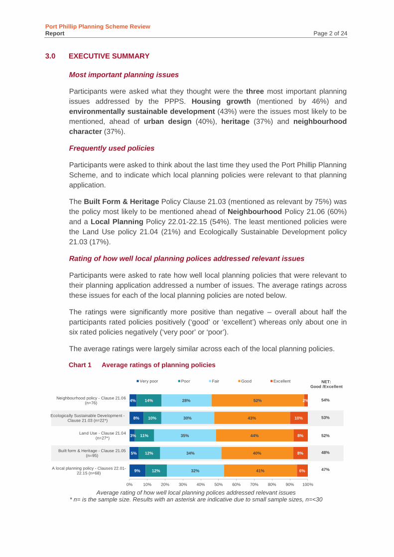
Port Phillip Planning Scheme Review Report Page 2 of 24
3.0 EXECUTIVE SUMMARY
Most important planning issues
Participants were asked what they thought were the three most important planning issues addressed by the PPPS. Housing growth (mentioned by 46%) and environmentally sustainable development (43%) were the issues most likely to be mentioned, ahead of urban design (40%), heritage (37%) and neighbourhood character (37%).
Frequently used policies
Participants were asked to think about the last time they used the Port Phillip Planning Scheme, and to indicate which local planning policies were relevant to that planning application.
The Built Form & Heritage Policy Clause 21.03 (mentioned as relevant by 75%) was the policy most likely to be mentioned ahead of Neighbourhood Policy 21.06 (60%) and a Local Planning Policy 22.01-22.15 (54%). The least mentioned policies were the Land Use policy 21.04 (21%) and Ecologically Sustainable Development policy 21.03 (17%).
Rating of how well local planning polices addressed relevant issues
Participants were asked to rate how well local planning policies that were relevant to their planning application addressed a number of issues. The average ratings across these issues for each of the local planning policies are noted below.
The ratings were significantly more positive than negative – overall about half the participants rated policies positively (‘good’ or ‘excellent’) whereas only about one in six rated policies negatively (‘very poor’ or ‘poor’).
The average ratings were largely similar across each of the local planning policies.
Chart 1 Average ratings of planning policies
Average rating of how well local planning polices addressed relevant issues
* n= is the sample size. Results with an asterisk are indicative due to small sample sizes, n=<30
9%
5%
3%
8%
4%
12%
12%
11%
10%
14%
32%
34%
35%
30%
28%
41%
40%
44%
43%
52%
6%
8%
8%
10%
2%
0% 10% 20% 30% 40% 50% 60% 70% 80% 90% 100%
A local planning policy - Clauses 22.01-22.15 (n=68)
Built form & Heritage - Clause 21.05(n=95)
Land Use - Clause 21.04(n=27*)
Ecologically Sustainable Development -Clause 21.03 (n=22*)
Neighbourhood policy - Clause 21.06(n=76)
Very poor Poor Fair Good Excellent NET: Good /Excellent
54%
52%
53%
48%
47%
Port Phillip Planning Scheme Review Report Page 3 of 24
Usability of the scheme
Only one in six (15%) of the participants disagreed that ‘the PPPS addresses relevant planning issues facing the municipality’. However, a substantial proportion believe the scheme can be repetitious and could be made clearer – close to two in five (39%) agreed that ‘there is a lot of repetition and unnecessary content in the PPPS’ and that ‘the policy is hard to understand and could be made clearer’ (also 39%).
Best and worse perceived aspects of the scheme
Participants were asked from their experience, what they thought were the best and worst aspects of the Port Phillip Planning Scheme. The most frequently mentioned positive responses (mentioned by 13% of participants) related to the scheme being clear and consistent. The most frequently mentioned negative aspects related to the scheme being unclear and open to interpretation (mentioned by 21%).
It is worth noting that the most frequently mentioned ‘best’ and ‘worst’ aspects of the scheme related to the perceived clarity of the scheme. This suggests that for participants the perceived clarity (or lack of) of the scheme is of some importance.
Suggested improvement to the scheme
Participants were presented with a list of options and asked what could be done to improve the effectiveness and clarity of the scheme. The responses suggest that there is some support for the scheme being simplified: the three most frequently mentioned responses were ‘reduce unnecessary and repetitive policy’ (noted by 60%), ‘rewrite policy to be more succinct’ (mentioned by 45%) and ‘improve the structure to make it easier to follow’ (40%).
Concluding comments
While participants were significantly more likely to believe than not that the PPPS addressed planning issues well, and few disagreed that the PPPS is relevant, a substantial proportion believe the scheme could be made clearer and more succinct.
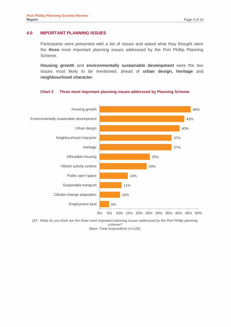
Port Phillip Planning Scheme Review Report Page 4 of 24
4.0 IMPORTANT PLANNING ISSUES
Participants were presented with a list of issues and asked what they thought were the three most important planning issues addressed by the Port Phillip Planning Scheme.
Housing growth and environmentally sustainable development were the two issues most likely to be mentioned, ahead of urban design, heritage and neighbourhood character.
Chart 2 Three most important planning issues addressed by Planning Scheme
Q3 - What do you think are the three most important planning issues addressed by the Port Phillip planning
scheme? Base: Total respondents (n=126)
5%
10%
11%
14%
24%
25%
37%
37%
40%
43%
46%
0% 5% 10% 15% 20% 25% 30% 35% 40% 45% 50%
Employment land
Climate change adaptation
Sustainable transport
Public open space
Vibrant activity centres
Affordable housing
Heritage
Neighbourhood character
Urban design
Environmentally sustainable development
Housing growth
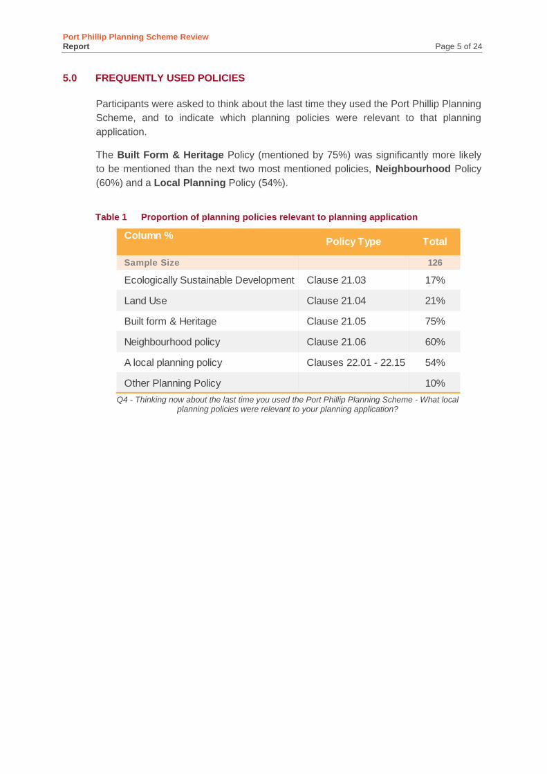
Port Phillip Planning Scheme Review Report Page 5 of 24
5.0 FREQUENTLY USED POLICIES
Participants were asked to think about the last time they used the Port Phillip Planning Scheme, and to indicate which planning policies were relevant to that planning application.
The Built Form & Heritage Policy (mentioned by 75%) was significantly more likely to be mentioned than the next two most mentioned policies, Neighbourhood Policy (60%) and a Local Planning Policy (54%).
Table 1 Proportion of planning policies relevant to planning application
Q4 - Thinking now about the last time you used the Port Phillip Planning Scheme - What local
planning policies were relevant to your planning application?
Column %
Sample Size 126
Ecologically Sustainable Development Clause 21.03 17%
Land Use Clause 21.04 21%
Built form & Heritage Clause 21.05 75%
Neighbourhood policy Clause 21.06 60%
A local planning policy Clauses 22.01 - 22.15 54%
Other Planning Policy 10%
TotalPolicy Type
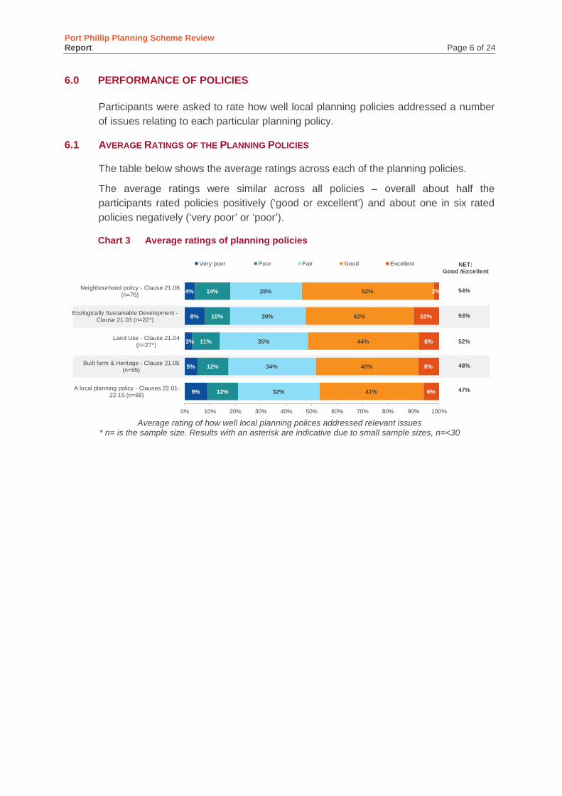
Port Phillip Planning Scheme Review Report Page 6 of 24
6.0 PERFORMANCE OF POLICIES
Participants were asked to rate how well local planning policies addressed a number of issues relating to each particular planning policy.
AVERAGE RATINGS OF THE PLANNING POLICIES 6.1
The table below shows the average ratings across each of the planning policies.
The average ratings were similar across all policies – overall about half the participants rated policies positively (‘good or excellent’) and about one in six rated policies negatively (‘very poor’ or ‘poor’).
Chart 3 Average ratings of planning policies
Average rating of how well local planning polices addressed relevant issues
* n= is the sample size. Results with an asterisk are indicative due to small sample sizes, n=<30
9%
5%
3%
8%
4%
12%
12%
11%
10%
14%
32%
34%
35%
30%
28%
41%
40%
44%
43%
52%
6%
8%
8%
10%
2%
0% 10% 20% 30% 40% 50% 60% 70% 80% 90% 100%
A local planning policy - Clauses 22.01-22.15 (n=68)
Built form & Heritage - Clause 21.05(n=95)
Land Use - Clause 21.04(n=27*)
Ecologically Sustainable Development -Clause 21.03 (n=22*)
Neighbourhood policy - Clause 21.06(n=76)
Very poor Poor Fair Good Excellent NET: Good /Excellent
54%
52%
53%
48%
47%
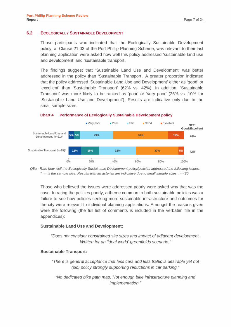
Port Phillip Planning Scheme Review Report Page 7 of 24
ECOLOGICALLY SUSTAINABLE DEVELOPMENT 6.2
Those participants who indicated that the Ecologically Sustainable Development policy, at Clause 21.03 of the Port Phillip Planning Scheme, was relevant to their last planning application were asked how well this policy addressed ‘sustainable land use and development’ and ‘sustainable transport’.
The findings suggest that ‘Sustainable Land Use and Development’ was better addressed in the policy than ‘Sustainable Transport’. A greater proportion indicated that the policy addressed ‘Sustainable Land Use and Development’ either as ‘good’ or ‘excellent’ than ‘Sustainable Transport’ (62% vs. 42%). In addition, ‘Sustainable Transport’ was more likely to be ranked as ‘poor’ or ‘very poor’ (26% vs. 10% for ‘Sustainable Land Use and Development’). Results are indicative only due to the small sample sizes.
Chart 4 Performance of Ecologically Sustainable Development policy
Q5a - Rate how well the Ecologically Sustainable Development policy/policies addressed the following issues. * n= is the sample size. Results with an asterisk are indicative due to small sample sizes, n=<30.
Those who believed the issues were addressed poorly were asked why that was the case. In rating the policies poorly, a theme common to both sustainable policies was a failure to see how policies seeking more sustainable infrastructure and outcomes for the city were relevant to individual planning applications. Amongst the reasons given were the following (the full list of comments is included in the verbatim file in the appendices):
Sustainable Land Use and Development:
“Does not consider constrained site sizes and impact of adjacent development. Written for an 'ideal world' greenfields scenario.”
Sustainable Transport:
“There is general acceptance that less cars and less traffic is desirable yet not (sic) policy strongly supporting reductions in car parking.”
“No dedicated bike path map. Not enough bike infrastructure planning and implementation.”
11%
5%
16%
5%
32%
29%
37%
48%
5%
14%
0% 20% 40% 60% 80% 100%
Sustainable Transport (n=19)*
Sustainable Land Use andDevelopment (n=21)*
Very poor Poor Fair Good Excellent NET: Good /Excellent
62%
42%
Port Phillip Planning Scheme Review Report Page 8 of 24
LAND USE POLICY 6.3
Those participants who indicated that the Land Use policy at Clause 21.04 of the Port Phillip Planning Scheme was relevant to their last planning application were asked how well this policy addressed several issues. Those issues are listed in the table below.
While results are indicative only due to the small sample sizes, they show that ‘Social Impact Assessment’ and ‘Industry’ policies were less likely to be rated favourably than other policies. ‘Subdivision’ was the policy most likely to receive a ‘good’ or ‘excellent’ rating.
Chart 5 Performance of Land Use policy
Q.5b - Rate how well the Land Use policy addressed the following issues
* n= is the sample size. Results with an asterisk are indicative due to small sample sizes, n=<30
All the reasons given by participants for believing the Land Use policy addressed these issues poorly are contained in the appendices of the report. There were a wide variety of comments, some of which included:
Public Open Space and Foreshore:
“Payments for public open space are too high.”
Social Impact Assessment:
“Council officers change their minds.”
“Too much emphasis on free or social housing.”
Tourism and the Arts:
6%
14%
4%
19%
15%
29%
7%
4%
5%
10%
6%
44%
54%
21%
29%
35%
36%
30%
29%
25%
23%
36%
36%
57%
50%
55%
53%
6%
8%
14%
14%
9%
5%
12%
0% 10% 20% 30% 40% 50% 60% 70% 80% 90% 100%
Social Impact Assessment (n=16)*
Industry (n=13)*
Public Open Space and Foreshore(n=14)*
Tourism and the Arts (n=14)*
Activity Centres (n=23)*
Housing and Accommodation(n=22)*
Office and Mixed Use Areas(n=20)*
Subdivision (n=17)*
Very poor Poor Fair Good Excellent NET: Good /Excellent
60%
50%
65%
59%
57%
50%
31%
31%

Port Phillip Planning Scheme Review Report Page 9 of 24
“Too restricted. Should be more free to appear and occur through the municipality.”
Office & Mixed Use/ Industry:
“Lack of guidance.”
Port Phillip Planning Scheme Review Report Page 10 of 24
BUILT FORM AND HERITAGE POLICY 6.4
The Built Form and Heritage policy at Clause 21.05 of the Port Phillip Planning Scheme was the policy most likely to be mentioned as relevant to planning applications – it was mentioned by 75% of participants.
Those participants who indicated that this policy was relevant to their last planning application were asked how well this policy addressed the issues listed in the table below.
Overall, participants were most likely to believe that ‘Heritage’ issues (57%) were well addressed by the Built Form and Heritage policy.
The ‘poor’ rating was similar across all four issues.
Chart 6 Built form and Heritage policy ability to address issues
Q.5c - Rate how well the Built Form & Heritage policy addressed the following issues
Those who believed the issues were addressed poorly were asked why they believed this to be the case – all the reasons given by participants are contained in the appendices of the report.
Heritage:
There were a number of common themes apparent in commentary amongst those who rated the Heritage policy poorly including the subjective nature of the policy, a lack of flexibility and inconsistency of heritage policy and approach:
“Total lack of objectivity. Policy is subjective and lacks logic.”
“Clearer guidance required and more flexibility for sections that have limited visibility from the street.”
“It is contradictory, over wrought, all over the place, and can be ripped apart at VCAT.”
4%
4%
6%
7%
14%
15%
8%
12%
39%
36%
41%
23%
36%
41%
40%
43%
7%
4%
5%
15%
0% 20% 40% 60% 80% 100%
Urban Design and the Public Realm(n=74)
Physical Infrastructure (n=73)
Urban Structure and Character(n=83)
Heritage (n=94)
Very poor Poor Fair Good Excellent NET: Good /Excellent
57%
45%
45%
43%

Port Phillip Planning Scheme Review Report Page 11 of 24
“Heritage citations and overlays drastically out of date. For example modern replacement buildings still have citation as significant Heritage buildings. Overlays
etc. need a detailed review.”
“The weighting required between heritage and ESD was not well recognised.”
Urban Structure and Character:
“By prioritising narrow heritage outcomes over good, functional and respectful upgrades, the planning scheme is resulting in some ugly but compliant
renovations.”
Physical Infrastructure:
“You have to satisfy whatever development you are doing has all the public amenity/in the response, they don't acknowledge that the
development is in a good public area has all the facilities like schools, public transport, shopping centres, trams and buses, which is one of the
requirements of Rescode.”
Urban Design and the Public Realm:
“The interface between new development and the public realm is poor.”
Port Phillip Planning Scheme Review Report Page 12 of 24
NEIGHBOURHOOD POLICIES 6.5
Those who had noted that the neighbourhood policy at Clause 21.06 of the Port Phillip Planning Scheme was relevant to their most recent application (60% of participants) were presented with a list of neighbourhood policies and asked which neighbourhood policies in particular were relevant. Those mentioned as relevant were:
• Middle Park and Albert Park (by 43% of those mentioning neighbourhood policies as being relevant)
• Port Melbourne and Garden City (38%)
• South Melbourne (33%)
• Elwood and Ripponlea (22%), and
• East St Kilda and Balaclava (16%)
• Fisherman’s bend Urban Renewal Area (5%), and
• St Kilda Road and Queen’s Road (3%).
Participants were asked to what extent the different neighbourhood policies addressed relevant issues – results were broadly similar across the different neighbourhoods with participants more likely to think the polices addressed policies well than poorly - between 47% and 60% believing the policies addressed relevant issues well (i.e. ‘good’ or ‘excellent’), and between 14% and 29% believing relevant issues were addressed poorly. ‘Elwood and Ripponlea’ was more likely to be rated poorly than other neighbourhood policies.
‘Fisherman’s Bend’ and ‘St Kilda Road and Queen’s Road’ are not included in the chart below due to insufficient sample size. They are included in the appendices.
Chart 7 Different Neighborhoods policies’ ability to address issues
Q.5d1 - Rate how well this policy addressed relevant issues
* n= is the sample size. Results with an asterisk are indicative due to small sample sizes, n=<30
6%
3%
3%
8%
24%
17%
13%
10%
12%
12%
24%
33%
38%
31%
30%
20%
47%
50%
50%
55%
55%
56% 4%
0% 10% 20% 30% 40% 50% 60% 70% 80% 90% 100%
Elwood and Ripponlea (n=17)*
East St Kilda and Balaclava(n=12)*
St Kilda (n=16)*
Port Melbourne and Garden City(n=29)*
Middle Park and Albert Park (n=33)
South Melbourne (n=25)*
Very poor Poor Fair Good Excellent NET: Good /Excellent
50%
60%
55%
55%
50%
47%
Port Phillip Planning Scheme Review Report Page 13 of 24
A wide variety of comments were given for poor ratings (see the appendices for the full list of comments). A common criticism throughout the neighbourhood policies was the inconsistency of heritage policies, the lack of recognition of the diversity within areas and no allowance for good design. Some of the reasons given for a poor rating were as follows:
Elwood and Ripponlea:
“It is a large area covering diverse neighbourhood characters lumped together under one expectation of design style. Ridiculous.”
“Nil flexibility in applications as partial/& individual overlays result in no cohesive streetscape.”
East St Kilda and Balaclava:
“Because the planning scheme has no scope to assess design from a design point of view. It only assesses it from a planning point of view, which means good
designs are knocked back, and an awful design, if it complies, is allowed. In this, the scheme fails badly.”
Middle Park and Albert Park:
“Heritage Policies over written and inconsistent.”
Port Melbourne and Garden City:
“Ignores the changed character of residential streetscapes, including the impact of change to buildings by post-war settlers. Ignores the visual impact of large
structures in adjoining streets. Two dimensional planning.”
South Melbourne:
“Ignores the diversity of building stock. Defaults to pretty Victorian era cottages as the development benchmark.”
St Kilda:
“There have been multiple sites researched that don't appear to have adequate controls - it seems the planning scheme can't keep up with the aging housing
stock - in one case, when we've had a heritage overlay, there are no controls. Or when we look at an older dwelling to which we anticipate a heritage overlay, we
find none. The neighbourhood character overlay is also lacking - where other Councils have gone to efforts to establish guidelines and recommendations, PP
hasn't.”
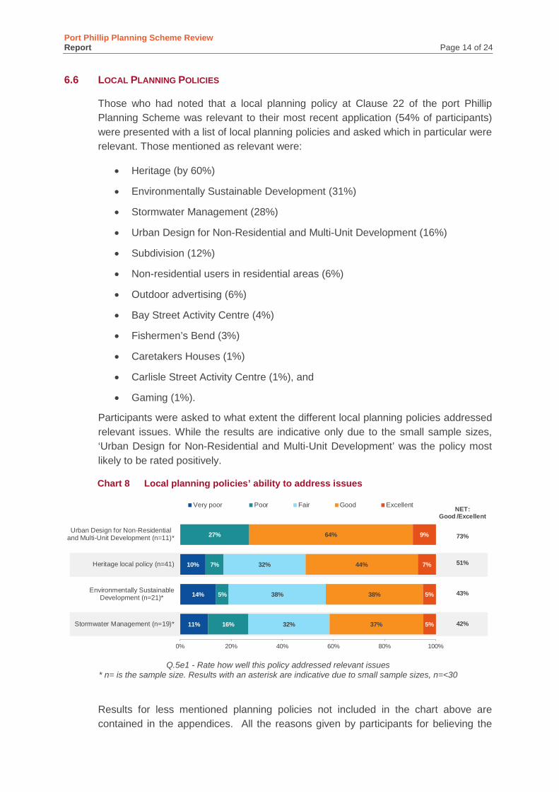
Port Phillip Planning Scheme Review Report Page 14 of 24
LOCAL PLANNING POLICIES 6.6
Those who had noted that a local planning policy at Clause 22 of the port Phillip Planning Scheme was relevant to their most recent application (54% of participants) were presented with a list of local planning policies and asked which in particular were relevant. Those mentioned as relevant were:
• Heritage (by 60%)
• Environmentally Sustainable Development (31%)
• Stormwater Management (28%)
• Urban Design for Non-Residential and Multi-Unit Development (16%)
• Subdivision (12%)
• Non-residential users in residential areas (6%)
• Outdoor advertising (6%)
• Bay Street Activity Centre (4%)
• Fishermen’s Bend (3%)
• Caretakers Houses (1%)
• Carlisle Street Activity Centre (1%), and
• Gaming (1%).
Participants were asked to what extent the different local planning policies addressed relevant issues. While the results are indicative only due to the small sample sizes, ‘Urban Design for Non-Residential and Multi-Unit Development’ was the policy most likely to be rated positively.
Chart 8 Local planning policies’ ability to address issues
Q.5e1 - Rate how well this policy addressed relevant issues * n= is the sample size. Results with an asterisk are indicative due to small sample sizes, n=<30
Results for less mentioned planning policies not included in the chart above are contained in the appendices. All the reasons given by participants for believing the
11%
14%
10%
16%
5%
7%
27%
32%
38%
32%
37%
38%
44%
64%
5%
5%
7%
9%
0% 20% 40% 60% 80% 100%
Stormwater Management (n=19)*
Environmentally SustainableDevelopment (n=21)*
Heritage local policy (n=41)
Urban Design for Non-Residentialand Multi-Unit Development (n=11)*
Very poor Poor Fair Good Excellent NET: Good /Excellent
73%
43%
51%
42%
Port Phillip Planning Scheme Review Report Page 15 of 24
Local Planning policies addressed these issues poorly are also contained in the appendices of the report. Reasons given included the following:
Heritage Local Policy:
“The heritage polices are out-dated and do not reflect present and future needs for well balanced, higher density housing and business development.”
“It is misleading, and often too restrictive. Also, trivial heritage matters like paint colour, that in this day in age, simply do not matter. Would you rather see a well painted 1890 weatherboard in whatever colour the owner likes? Or a peeling un loved version of the same thing in the original paint. It’s not a time capsule, stop
trying to preserve it like one. Let people adapt to the future.”
Environmentally Sustainable Development:
“Is great on a theoretical level but very difficult to apply in reality. Requires addressing detailed decisions that are not appropriate so early in the design
process.”
Stormwater Management:
A common theme among comments rating the stormwater management policy was the lack of flexibility of the policy in terms of considering site context like the:
“Reality of Victorian terraces.”
and
“Assuming every site can accommodate a rain garden.”
Urban Design for Non-Residential and Multi-Unit Development:
“Could not give adequate guidance as to reasons for non-support of a development. Designed by award winning architect, that judges architecture and teaches architecture. Planning scheme too generic. Needs to be place based.
Planners need to use 3D tools to assess planning permit applications.”
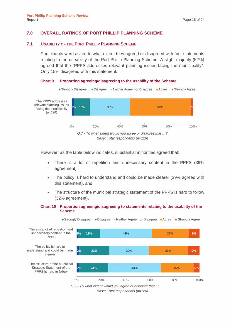
Port Phillip Planning Scheme Review Report Page 16 of 24
7.0 OVERALL RATINGS OF PORT PHILLIP PLANNING SCHEME
USABILITY OF THE PORT PHILLIP PLANNING SCHEME 7.1
Participants were asked to what extent they agreed or disagreed with four statements relating to the useability of the Port Phillip Planning Scheme. A slight majority (52%) agreed that the “PPPS addresses relevant planning issues facing the municipality”. Only 15% disagreed with this statement.
Chart 9 Proportion agreeing/disagreeing to the usability of the Scheme
Q.7 - To what extent would you agree or disagree that …?
Base: Total respondents (n=126)
However, as the table below indicates, substantial minorities agreed that:
• There is a lot of repetition and unnecessary content in the PPPS (39% agreement)
• The policy is hard to understand and could be made clearer (39% agreed with this statement), and
• The structure of the municipal strategic statement of the PPPS is hard to follow (32% agreement).
Chart 10 Proportion agreeing/disagreeing to statements relating to the usability of the Scheme
Q.7 - To what extent would you agree or disagree that…? Base: Total respondents (n=126)
2% 13% 33% 50% 2%
0% 20% 40% 60% 80% 100%
The PPPS addressesrelevant planning issuesfacing the municipality
(n=126)
Strongly Disagree Disagree Neither Agree nor Disagree Agree Strongly Agree
2%
2%
1%
24%
23%
18%
43%
30%
42%
27%
30%
30%
5%
9%
9%
0% 20% 40% 60% 80% 100%
The structure of the MunicipalStrategic Statement of the
PPPS is hard to follow
The policy is hard tounderstand and could be made
clearer
There is a lot of repetition andunnecessary content in the
PPPS
Strongly Disagree Disagree Neither Agree nor Disagree Agree Strongly Agree
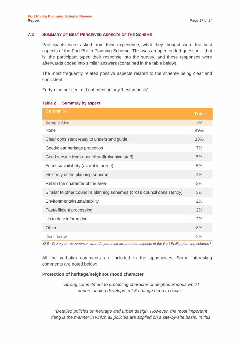
Port Phillip Planning Scheme Review Report Page 17 of 24
SUMMARY OF BEST PERCEIVED ASPECTS OF THE SCHEME 7.2
Participants were asked from their experience, what they thought were the best aspects of the Port Phillip Planning Scheme. This was an open ended question – that is, the participant typed their response into the survey, and these responses were afterwards coded into similar answers (contained in the table below).
The most frequently related positive aspects related to the scheme being clear and consistent.
Forty-nine per cent did not mention any ‘best aspects’.
Table 2 Summary by aspect
Q.8 - From your experience, what do you think are the best aspects of the Port Phillip planning scheme?
All the verbatim comments are included in the appendices. Some interesting comments are noted below:
Protection of heritage/neighbourhood character
“Strong commitment to protecting character of neighbourhoods whilst understanding development & change need to occur.”
“Detailed policies on heritage and urban design. However, the most important thing is the manner in which all policies are applied on a site-by-site basis. In this
Column %
Sample Size 126
None 49%
Clear consistent /easy to understand guide 13%
Good/clear heritage protection 7%
Good service from council staff(planning staff) 5%
Access/availability (available online) 5%
Flexibility of the planning scheme 4%
Retain the character of the area 3%
Similar to other council’s planning schemes (cross council consistency) 3%
Environmental/sustainability 2%
Fast/efficient processing 2%
Up to date information 2%
Other 8%
Don't know 2%
Total
Port Phillip Planning Scheme Review Report Page 18 of 24
regard policies should provide guiding principles and not be a tick box exercise as can happen.”
“Seeks to protect Heritage even if in a haphazard & arbitrary manner.”
“Much of the heritage policy is quite clear in what it stipulates as requirements, e.g. sight lines. Heritage can be very subjective, and strictly outline requirements
help remove this grey area and confusion.”
Clarity/guidance
“Port Phillip Council is clear in what they want submitted for a planning application - this expedites the process.”
“Deemed-to-satisfy standards diagrams.”
“There is a good amount of local planning policies to identify what council expects.”
“Environmental approach, sustainable approach.”
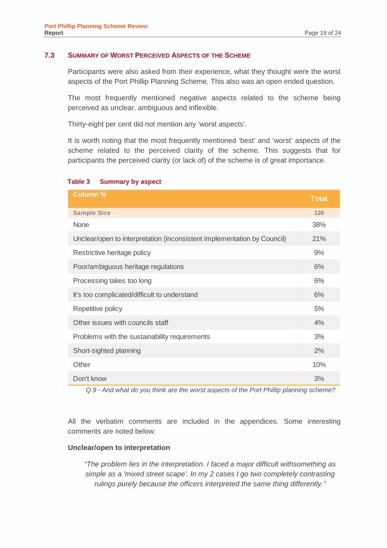
Port Phillip Planning Scheme Review Report Page 19 of 24
SUMMARY OF WORST PERCEIVED ASPECTS OF THE SCHEME 7.3
Participants were also asked from their experience, what they thought were the worst aspects of the Port Phillip Planning Scheme. This also was an open ended question.
The most frequently mentioned negative aspects related to the scheme being perceived as unclear, ambiguous and inflexible.
Thirty-eight per cent did not mention any ‘worst aspects’.
It is worth noting that the most frequently mentioned ‘best’ and ‘worst’ aspects of the scheme related to the perceived clarity of the scheme. This suggests that for participants the perceived clarity (or lack of) of the scheme is of great importance.
Table 3 Summary by aspect
Q.9 - And what do you think are the worst aspects of the Port Phillip planning scheme?
All the verbatim comments are included in the appendices. Some interesting comments are noted below:
Unclear/open to interpretation
“The problem lies in the interpretation. I faced a major difficult withsomething as simple as a 'mixed street scape'. In my 2 cases I go two completely contrasting
rulings purely because the officers interpreted the same thing differently.”
Column %
Sample Size 126
None 38%
Unclear/open to interpretation (inconsistent implementation by Council) 21%
Restrictive heritage policy 9%
Poor/ambiguous heritage regulations 6%
Processing takes too long 6%
It’s too complicated/difficult to understand 6%
Repetitive policy 5%
Other issues with councils staff 4%
Problems with the sustainability requirements 3%
Short-sighted planning 2%
Other 10%
Don't know 3%
Total
Port Phillip Planning Scheme Review Report Page 20 of 24
“Policies can be vaguely worded sometimes.”
Rigid/inflexible/restrictive
“Lacks flexibility in parts for varying site sizes. Many inconsistencies.”
“Unrealistic requirements of small lots re stainability/permeability measures.”
Restrictive heritage policy
“Outdated and arbitrary nature of the heritage provisions. They fail to meet the objectives of the Planning and Environment Act.”
“The heritage guidelines are 'for dummies' so they stifle thinking laterally.”
“Heritage policy in particular the flawed '10 degree' envelope.”
Too complicated/ repetitive
“Obscure, needlessly complex, no cross-referencing, not plain English.”
“Repetition between DDOs and urban design policy; wordiness of MSS, policies and DDOs which make it hard to ultimately interpret what the Council wants to see
happen / will promote as good outcomes for the municipality.”
“Not user friendly, difficult to find relevant things for the layperson and repetitive.”
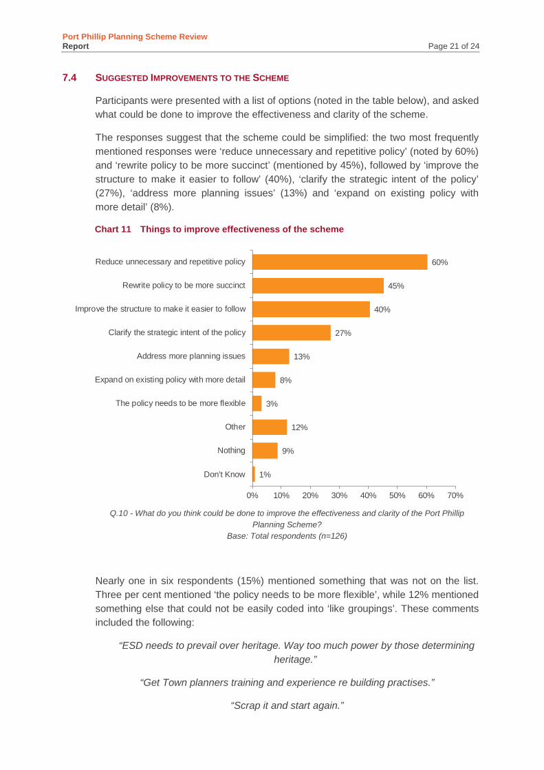
Port Phillip Planning Scheme Review Report Page 21 of 24
SUGGESTED IMPROVEMENTS TO THE SCHEME 7.4
Participants were presented with a list of options (noted in the table below), and asked what could be done to improve the effectiveness and clarity of the scheme.
The responses suggest that the scheme could be simplified: the two most frequently mentioned responses were ‘reduce unnecessary and repetitive policy’ (noted by 60%) and ‘rewrite policy to be more succinct’ (mentioned by 45%), followed by ‘improve the structure to make it easier to follow’ (40%), ‘clarify the strategic intent of the policy’ (27%), ‘address more planning issues’ (13%) and ‘expand on existing policy with more detail’ (8%).
Chart 11 Things to improve effectiveness of the scheme
Q.10 - What do you think could be done to improve the effectiveness and clarity of the Port Phillip
Planning Scheme? Base: Total respondents (n=126)
Nearly one in six respondents (15%) mentioned something that was not on the list. Three per cent mentioned ‘the policy needs to be more flexible’, while 12% mentioned something else that could not be easily coded into ‘like groupings’. These comments included the following:
“ESD needs to prevail over heritage. Way too much power by those determining heritage.”
“Get Town planners training and experience re building practises.”
“Scrap it and start again.”
1%
9%
12%
3%
8%
13%
27%
40%
45%
60%
0% 10% 20% 30% 40% 50% 60% 70%
Don’t Know
Nothing
Other
The policy needs to be more flexible
Expand on existing policy with more detail
Address more planning issues
Clarify the strategic intent of the policy
Improve the structure to make it easier to follow
Rewrite policy to be more succinct
Reduce unnecessary and repetitive policy
Port Phillip Planning Scheme Review Report Page 22 of 24
“Some form of pre-application meeting where you get one form of opinion and Council should then stick to that… it is very hard to speak to the town planners and get any
feedback or response from them.”
“Make parts of the scheme more specific to the character of the municipality.”
“Need to adopt a better sustainability policy that relies less on a checklist and score and is able to be more nuanced for the type of projects being developed. The
software program used is completely inflexible to the point where in order to be able to move forward you end up putting in data to gets the answer that is required rather
than building a case for a solution that is most appropriate for the project.”
“Have the public review. Which policy over rides which??? Heritage overrides Environment. There’s a gang that get their way, no matter what any document
actually says, or does not say.”
“Refer to experts in relevant fields as independent advisory services to better understand what other options are available to consider.”
“More responsive and timely planning assessment.”
“Employ more planners.”
During other parts of the survey some participants offered suggested improvements to the scheme. Some of these comments included the following:
Overall structure/clarity/consistency
“It could be structured better to reflect the staged process of design which should be the same process as assessment of an application.”
“Should be using more visual tools and 3D tools to plan, explain and assess developments.”
“Having a clear map of activity centres”
Certainty “Port Phillip needs to be able to give certainty to all players - the new residential areas
help, and other zoning changes assist. Reinforcing and applying those policies to ensure the edges of controls are not blurred too much, whilst maintaining some
flexibility to review an application on its merits is a difficult and somewhat fraught aspect of planning.”
Design
“Focus on good development outcomes in a holistic manner. This doesn't start with placing mandatory requirements on height, which appears to be the basis for recent
policy.”
Port Phillip Planning Scheme Review Report Page 23 of 24
Heritage improvements
“Expand your heritage colour scheme.”
“10º site line, should revert back to 12º.”
“Remove the site line for second storeys. Europeans have been adding second and third and fourth storeys to buildings for centuries. You are ending up with squashed second storeys. Focus on what is well designed. Also allow minor extensions to be carried out in matching materials rather than requiring a modern extension to an old
residence.
Faster processing
If the majority of planning applications are procedural please fast track them so that more time can be put into controversial applications.
Sustainable Development
“Please review the sustainability assessment program. It produces meaningless results rather than encouraging better design.
“Need to prioritise the Copenhagen model of bike paths. With a grade separation and surface type changes between cars and bikes, bikes and pedestrians. Nowhere near
enough is being done to back cycling safe and feasible.”
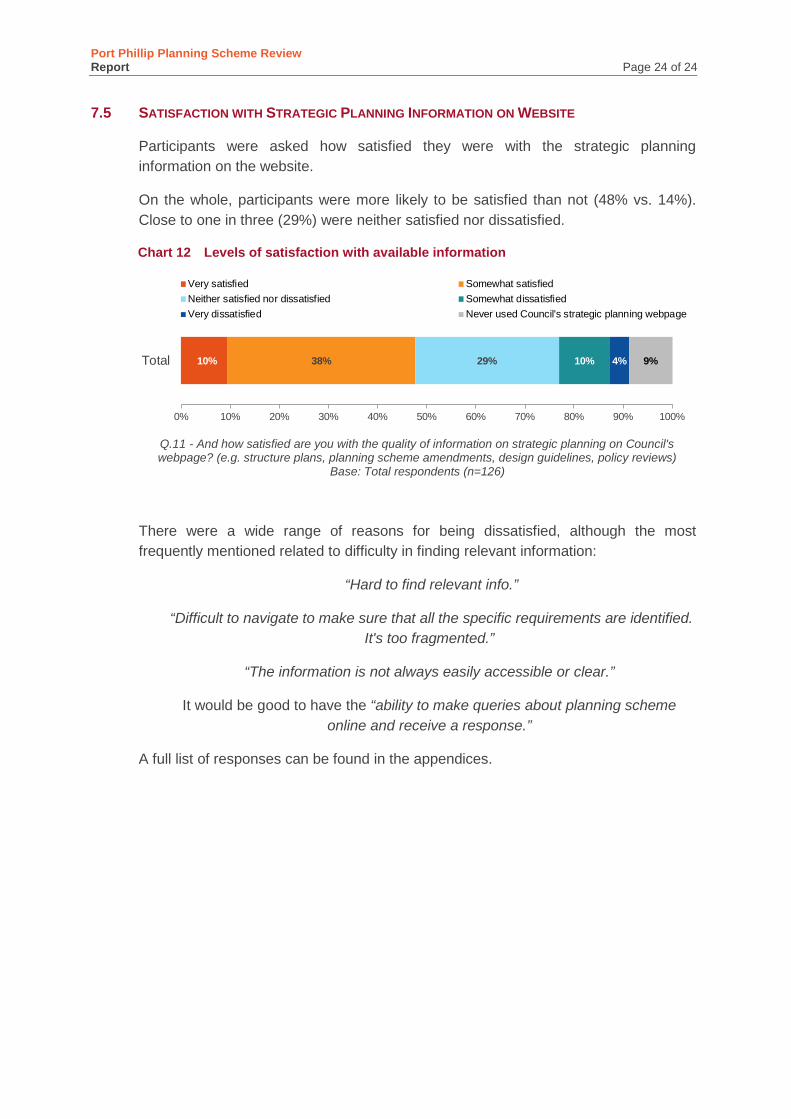
Port Phillip Planning Scheme Review Report Page 24 of 24
SATISFACTION WITH STRATEGIC PLANNING INFORMATION ON WEBSITE 7.5
Participants were asked how satisfied they were with the strategic planning information on the website.
On the whole, participants were more likely to be satisfied than not (48% vs. 14%). Close to one in three (29%) were neither satisfied nor dissatisfied.
Chart 12 Levels of satisfaction with available information
Q.11 - And how satisfied are you with the quality of information on strategic planning on Council's webpage? (e.g. structure plans, planning scheme amendments, design guidelines, policy reviews)
Base: Total respondents (n=126)
There were a wide range of reasons for being dissatisfied, although the most frequently mentioned related to difficulty in finding relevant information:
“Hard to find relevant info.”
“Difficult to navigate to make sure that all the specific requirements are identified. It's too fragmented.”
“The information is not always easily accessible or clear.”
It would be good to have the “ability to make queries about planning scheme online and receive a response.”
A full list of responses can be found in the appendices.
10% 38% 29% 10% 4% 9%
0% 10% 20% 30% 40% 50% 60% 70% 80% 90% 100%
Total
Very satisfied Somewhat satisfiedNeither satisfied nor dissatisfied Somewhat dissatisfiedVery dissatisfied Never used Council's strategic planning webpage