Embed Size (px)
Citation preview
ICOMOS Report for the World Heritage Committee, 35th ordinary session UNESCO, June 2011
WHC-11/35.COM/INF.8B1

UNESCO World Heritage Convention World Heritage Committee
2011 Evaluations of Nominations of Cultural and Mixed Properties ICOMOS report for the World Heritage Committee, 35th ordinary session UNESCO, June 2011

Secrétariat ICOMOS International 49-51 rue de la Fédération 75015 Paris France Tel : 33 (0)1 45 67 67 70 Fax : 33 (0)1 45 66 06 22
World Heritage List Nominations 2011 I Introduction
ICOMOS analysis of nominations 1 ICOMOS procedure 5 ICOMOS check tool recommendations 9 Summary of ICOMOS recommendations 11
II Tables Alphabetical Index of the evaluations (by State Party) 15 Nominations by category 17 Geographical spread of nominations 19 Numerical Index of the evaluations 21 Technical evaluation mission experts 23
World Heritage List Nominations received by 1st February 2010
III Mixed properties A Africa
New nominations Senegal [N/C 1359] Saloum Delta 25
B Arab States
New nominations Jordan [N/C 1377] Wadi Rum Protected Area 38
C Latin America and the Caribbean
New nominations Jamaica [N/C 1356] Blue and John Crow Mountains National Park 52
IV Cultural properties A Africa
New nominations Nigeria [C 1332] Oke-Idanre Cultural Landscape 63
B Arab States
New nominations Bahrain [C 1364] Pearling, testimony of an island economy 72
Saudi Arabia [C 1361] The Historical City of Jeddah 85 Sudan [C 1336] The Archaeological Sites of the Island of Meroe 96 Syrian Arab Republic [C 1348] The Ancient Villages of Northern Syria 111 United Arab Emirates [C 1343] The Cultural Sites of Al Ain (Hafit, Hili, Bidaa Bint Saud and Oases Areas) 127
C Asia – Pacific
New nominations China [C 1334] West Lake Cultural Landscape of Hangzhou 140 India [C 1375] Santiniketan 155 Iran [C 1372] The Persian Garden 170 Micronesia / Palau [C 1340] Yapese Stone Money Sites in Palau and Yap 185 Mongolia [C 1382] Petroglyphic Complexes of the Mongolian Altai 201 Viet Nam [C 1358] Citadel of the Ho Dynasty 211 Properties deferred or referred back by previous sessions of the World Heritage Committee Japan [C 1277rev] Hiraizumi – Temples, Gardens and Archaeological Sites Representing the Buddhist Pure Land 224
D Europe – North America
New nominations Germany [C 1368] Fagus Factory 238 Israel [C 1370]
Land of Caves and Hiding in the Judean Lowlands, Maresha, Bet-Guvrin and Adulam 250 Italy [C 1318] The Longobards in Italy. Places of the power (568-774 A.D.) 264 Spain [C 1371] Cultural Landscape of the Serra de Tramuntana 277 Switzerland, Austria, France, Germany, Italy, Slovenia [C 1363] Prehistoric Pile Dwellings around the Alps 292 Turkey [C 1354] Old City and Ramparts of Alanya with Seljuk Shipyard 307
Turkey [C 1366] Selimiye Mosque and its Social Complex 317 Ukraine [C 1330] The Residence of Bukovinian and Dalmatian Metropolitans 330
E Latin America and the Caribbean
New nominations Barbados [C 1376] Historic Bridgetown and its Garrison 340 Colombia [C 1121] Coffee Cultural Landscape 355 Mexico [C 1357] Fundidora Monterrey Blast Furnaces 367
Properties deferred or referred back by previous sessions of the World Heritage Committee Nicaragua [C 1236rev] León Cathedral 378
World Heritage List Nominations received by 1st February 2011 See Addendum (WHC-11/35.COM/INF.8B1.Add) which will include as well minor modifications to boundaries and creations of buffer zone
V Cultural properties
A Africa
Properties referred back by previous sessions of the World Heritage Committee Ethiopia [C 1333rev] The Konso Cultural Landscape Kenya [C 1295rev] Fort Jesus, Mombasa
B Europe
Properties referred back by previous sessions of the World Heritage Committee France [C 1153rev] The Causses and the Cévennes France, Argentina, Belgium, Germany, Japan, Switzerland [C 1321rev]
The architectural work of Le Corbusier, an outstanding contribution to the Modern Movement Israel [C 1105rev] The Triple-arch Gate at Dan

1
I Introduction
ICOMOS Analysis of nominations In 2011, ICOMOS was called on to evaluate 48 nominations. They consisted of: 29 new nominations 6 referred back nominations 1 deferred nomination 12 minor modifications/creations of buffer zone The geographical spread is as follows: Europe and North America Total: 17 nominations, 12 countries 9 new nominations 5 minor modifications/creations of buffer zone 3 referred back (17 cultural properties) Latin America and the Caribbean Total: 9 nominations, 8 countries 4 new nominations 2 referred back 3 minor modifications/creations of buffer zone (8 cultural properties, 1 mixed property) Arab States Total: 7 nominations, 6 countries 6 new nominations 1 minor modification/creation of buffer zone (6 cultural properties, 1 mixed property) Africa Total: 5 nominations, 5 countries 2 new nominations 2 referred back 1 minor modification/creation of buffer zone (4 cultural properties, 1 mixed property) Asia-Pacific Total: 10 nominations, 10 countries 6 new nominations 1 referred back 1 deferred 2 minor modifications/creations of buffer zone (9 cultural properties, 1 mixed property)
General remarks 1. Quality and complexity of nomination dossiers Generally speaking, ICOMOS notes that nominations are increasingly complex, sometimes to the detriment of the dossiers’ clarity and coherence. Certain nominations would benefit if more time were taken in preparing the nomination, for example to complete the legal protection process, finalise a management plan or undertake additional research. ICOMOS hopes that the publication of the Resource Manual for the Preparation of Nominations, of which an electronic version is now available on its website, and on the World Heritage Centre website, will help the State Parties to improve the quality of nomination dossiers. In most cases, the weakest parts of the nomination dossiers are the comparative analysis, integrity and/or monitoring. When evaluating the comparative analysis included in nomination dossiers, ICOMOS examines the methodology used by the State Party and the relevance of the examples given by using the following parameters. Comparisons should be drawn with properties expressing the same values as the nominated property and within a defined geo-cultural area. Therefore the values need to be clearly defined and the geo-cultural framework should be determined according to these values. Comparisons should be drawn with similar properties already inscribed on the World Heritage List and with other examples at national and international level within the defined geo-cultural area. On the basis of the above, ICOMOS indicates whether or not the comparative analysis is complete and whether or not the analysis justifies consideration of the property for the World Heritage List. If the nomination is considered incomplete or insufficient according to the parameters indicated above, ICOMOS requests additional information from the State Party, checks relevant ICOMOS thematic studies, and the wealth of information available about properties already evaluated and/or inscribed on the World Heritage List, and on the Tentative Lists, and
2
consults the ICOMOS network of experts to improve its understanding of the nomination. ICOMOS wishes to point out that its role is to evaluate the properties and not the nominations (i.e. the dossiers). Similarly, it evaluates the protection, conservation and management of the property at the time of the nomination and not at some unspecified time in the future after the adoption of the laws and management plans. It is the duty of ICOMOS to indicate to the Committee whether or not adequate protection and management are in place prior to inscription. 2. ICOMOS evaluations The objective of ICOMOS is the conservation and long-term protection and presentation of the cultural heritage, whether or not it is of outstanding universal value. In formulating its recommendations, ICOMOS therefore aims to be as helpful as possible to State Parties, whatever the final recommendation proposed. ICOMOS is well aware that it cannot please everyone. Despite being under considerable pressure, not only from State Parties, it must remain objective, rigorous and scientific, and its first duty remains the conservation of properties. 3. Strengthening of dialogue with State Parties The measures introduced in 2008 with a view to improving and strengthening dialogue with the State Parties have been maintained. The requests for additional information were sent out prior to the carrying out of the evaluation process. The ICOMOS World Heritage Panel meeting was held at the beginning of December 2010 instead of during January 2011, so that the letters requesting additional information could be sent out in December, leaving the State Parties more time to reply. The replies provided by the State Parties have in many cases confirmed or assisted the adoption of the final recommendations made by ICOMOS. 4. “Referred back” nominations – “Deferred” nominations At the request of the World Heritage Committee, ICOMOS and IUCN presented at the 34th session in Brasilia an information document concerning the processes, points of reference and time constraints arising from decisions to refer back or defer the examination of a nomination.
ICOMOS wishes to once again express its concerns about the difficulties raised when a “deferred” recommendation is changed into a “referred back” recommendation, which does not allow the advisory bodies to carry out an appropriate evaluation of nominations which are in many cases entirely new. In its recommendations, ICOMOS clearly distinguishes between nominations which are recommended to be referred back and those which are deferred. For referred back nominations, outstanding universal value has been demonstrated to the satisfaction of ICOMOS; supplementary information must be supplied to satisfy other requirements of Operational Guidelines, but no further technical evaluation mission will be required. For deferred nominations, the very nature of the information requested (a more thorough study, major reconsideration of boundaries, a request for a substantial revision, or serious gaps as regards management and conservation issues) means that a new mission and consideration by the full ICOMOS World Heritage Panel are necessary to evaluate the nomination again, and to ensure that it has the consideration needed to advance the nomination further. 5. "Minor" modifications to boundaries The number of such requests has greatly increased (from 2 requests in 2005 to 12 requests in 2011). They originate either from monitoring, the retrospective inventory or periodic reporting. The examination of these requests involves a considerable workload for ICOMOS in terms of examining the initial nomination, progress reports on conservation and earlier decisions of the World Heritage Committee, research, consultations and analysis. This year several requests for minor modifications were made by State Parties in respect of a report on the state of conservation or a retrospective inventory. To ensure that they are examined in the most favourable conditions, ICOMOS encourages State Parties to submit a separate request complying with the procedures set out in the Operational Guidelines for the Implementation of the World Heritage Convention and within the prescribed deadlines, i.e. 1st February at the latest. ICOMOS also notes that all modifications to the boundaries of a property and its buffer zone are proposed as "minor" modifications, even when they constitute in fact substantial modifications to the property, or even in some cases an extension of the property. According to the Operational Guidelines, proposals for major modifications, whether extensions
3
or reductions, constitute a new nomination (paragraph 165). ICOMOS recommends to the Committee that this provision should be consistently and rigorously applied. 6. Serial nominations and extensions The Operational Guidelines stipulate that for serial properties, the component parts must be related and the series as a whole must have outstanding universal value (paragraph 137). ICOMOS is aware that this is an active matter for consideration by the World Heritage Committee. This year, ICOMOS has examined 14 serial nominations, including 269 monuments, ensembles and sites. These nominations require a more substantial investment in terms of human and financial resources at all levels of evaluation of the properties. Because the number of serial nominations is growing, this needs to be taken into account in the budgets and contracts. Furthermore, ICOMOS notes that there are also calendar pressures arising from the task of evaluating these large and complex serial nominations and repeats its suggestion, supported by the Jade Tabet1 review, that the World Heritage Committee give consideration to an extended timeframe for these kinds of nominations. A specific evaluation format was set up in 2009 for the serial nominations and extensions. ICOMOS explicitly informs the Committee of the questions it asks in relation to the nature of serial nominations: a) What is the justification for the serial approach? b) How were the chosen sites selected? How do they each relate to the overall Outstanding Universal Value of the property? c) Does the comparative analysis justify the selection of properties? d) Are the separate components of the property functionally linked? e) Is there an overall management framework for all components? The answers to these questions have been integrated in the evaluation format under relevant sections. 7. Development projects To address the growing need to identify development projects within World Heritage properties during the evaluation cycle, ICOMOS has included in its letters
1Tabet J., Review of ICOMOS’ working methods and procedures for the evaluation of cultural and mixed properties nominated for inscription on the UNESCO World Heritage List, Paris, ICOMOS, 2010.
to the State Parties a specific question intended to bring to ICOMOS’ attention any development projects that are planned within the nominated property or in its vicinity, to ensure that comprehensive information is received concerning these potential projects. This has been introduced to respond to growing concern felt by the World Heritage Committee about such development plans and projects. ICOMOS has once again suggested that during the nomination evaluation procedure the Committee should apply provisions similar to those stipulated in paragraph 172, inviting the States Parties to inform the Committee of “their intention to undertake or to authorize in an area protected under the Convention major restorations or new constructions which may affect the outstanding universal value of the property […]. ICOMOS points out that it has drawn up a document entitled “Guidance on impact assessments for cultural World Heritage sites”, which was made available to the World Heritage Committee at its 34th session, and can be consulted on its website. 8. Issue of calendar and timing ICOMOS is working under increasing time pressure due to the growing number of complex nominations (serial properties and cultural landscapes). Furthermore, in the past, supplementary information received from States Parties was examined after the meeting of the Bureau of the World Heritage Committee, which was held in June/July, following the initial assessment process for nominations. Today this examination is carried out during the evaluation period itself, well ahead of the World Heritage Committee meeting.

4
5
ICOMOS procedure
The ICOMOS procedure is described in Annex 6 of the Operational Guidelines for the Implementation of the World Heritage Convention. It is regulated by the Policy for the implementation of the ICOMOS World Heritage mandate (revised in November 2007 and October 2010). This document is available on the ICOMOS web site: www.international.icomos.org. This policy makes public the existing procedure, and sets out the fair, transparent and credible approach ICOMOS adopts in fulfilling its world heritage remit, and the way it avoids conflicts of interest. The evaluation of nominations is coordinated by the World Heritage Unit of the International Secretariat of ICOMOS, in collaboration with the ICOMOS World Heritage Working Group and the ICOMOS World Heritage Panel. The ICOMOS World Heritage Working Group consists of officers of ICOMOS, the World Heritage Unit and ICOMOS advisers. It meets three or four times a year, and is responsible for the guidance and orientation of work relating to the World Heritage. The ICOMOS World Heritage Panel, which brings together some thirty persons, is made up of members of the ICOMOS Executive Committee and of experts who are invited each year depending on the nature of the properties nominated (rock art, 20th century heritage, industrial heritage, etc.). TICCIH and DoCoMoMo are also invited to participate in discussions in which their expertise is relevant. The Panel represents the various professional, geographic and cultural sensibilities present at the international level. It prepares the ICOMOS recommendations for each nomination on a collegial basis. For each nominated property, ICOMOS assesses: • Whether it bears testimony of an outstanding
universal value: - whether it meets the criteria of the
Operational Guidelines; - whether it meets the conditions of authenticity
and integrity; • Whether legal protection is adequate; • Whether the management processes are
satisfactory.
All properties are given equal attention, and ICOMOS also makes every effort to be as objective, scientific and rigorous as possible. In order to reinforce consistency of the evaluations and recommendations, and to check which additional information requests should be sent to State Parties, ICOMOS uses a check box tool. This tool is included in this volume, together with a table summing up ICOMOS’ recommendations for the nominations. In October 2010, a specific session with the advisers was organised to ensure consistency of approach on all aspects throughout all evaluations. An external review of the principles, methods and procedures used by ICOMOS in evaluating nominations was carried out in 2009. The final report and the ICOMOS response were made available to the World Heritage Committee at its 34th session.
1. Preparatory work The preparatory work is done in several stages: a. Initial study of dossiers: This first stage of the work consists of the creation of an inventory of the nomination dossier documents, a study of them to identify the various issues relating to the property and the choice of the various experts who will be called on to study the dossier (ICOMOS advisers, experts for mission, experts for consultations). A compilation of all relevant comparative material (Tentative Lists, properties already on the World Heritage List, nomination dossiers, “filling the gaps” ICOMOS study, etc.) is prepared in order to assist the work of the advisers on the specific item of comparative analysis. b. Consultations: Experts are consulted to express their opinion about the comparative analysis and the outstanding universal value of the nominated properties with reference to the ten criteria set out in the Operational Guidelines for the Implementation of the World Heritage Convention (January 2008), § 77. For this purpose, ICOMOS calls on the following:
ICOMOS International Scientific Committees;
Individual ICOMOS members with special expertise, identified after consultation with International and National Committees;
6
Non-ICOMOS members with specific expertise, identified after consultation within the ICOMOS networks.
For the nominations to be considered by the World Heritage Committee at its 35th session, around a hundred experts were consulted. c. Technical evaluation missions: As a rule, ICOMOS calls on a person from the region in which the nominated property is located. The objective of the missions is to study the authenticity, integrity, factors affecting the property, protection, conservation and management (Operational Guidelines, § 78). Experts are sent a copy of the nomination (or all relevant parts of it, when the dossier is particularly extensive), a note with key questions based on a preliminary examination of the dossiers, documentation on the Convention and detailed guidelines for evaluation missions. All experts have a duty of confidentiality. Their opinion about the nomination does not necessarily reflect that of the organisation; it is the ICOMOS World Heritage Panel which, after acquainting itself with all the information, analyses it and determines the organisation's position. Missions are sent to all the nominated properties except in the case of nominations referred back for which the Operational Guidelines do not stipulate that a mission is necessary. (Note: The principle is that properties are referred back because additional information is necessary, and not because thorough or substantial modifications are needed; the deadlines set in the Operational Guidelines mean moreover that it is not possible to organise missions, desk reviews or consideration by the full ICOMOS World Heritage Panel for properties referred back). 29 experts representing 25 countries took part in field missions as part of the evaluation of the 29 nominated properties, which in turn represented 31 countries. Technical evaluation missions were carried out jointly with IUCN for three mixed property nominations and one cultural landscape nomination. This year IUCN attended the ICOMOS World Heritage Panel meeting as an observer and ICOMOS took part in a conference call held during the IUCN panel meeting. ICOMOS and IUCN have also exchanged information about draft recommendations concerning mixed property nominations.
ICOMOS received comments from the IUCN concerning six cultural landscape nominations. These comments have been included in the evaluations and taken into account by ICOMOS in its recommendations. 2. Evaluations and recommendations a. ICOMOS World Heritage Panel: Draft evaluations (in either English or French) were prepared on the basis of the information contained in the nomination dossiers, mission reports, consultations and research. They were examined by the ICOMOS World Heritage Panel at a meeting in Paris from 2 to 5 December 2010. The Panel defined the recommendations and identified the additional information requests to be sent to the State Parties. b. Additional information request: Additional information requests for some of the nominated properties were sent to the State Parties by 31 January 2011, in accordance with the normal procedure. All documents received by 28 February 2011 were examined by the World Heritage Working Group at its meeting on 10 and 11 March 2011. c. Finalisation of the evaluation volume and its presentation to the World Heritage Committee: Following these meetings, revised evaluations have been prepared in both working languages, printed and dispatched to the UNESCO World Heritage Centre for distribution to members of the World Heritage Committee at its 35th session in June 2011. Nominated properties and ICOMOS recommendations will be presented to the World Heritage Committee by ICOMOS advisers in PowerPoint form. As an advisory body, ICOMOS makes a recommendation based on an objective, rigorous and scientific analysis. However, decisions are the responsibility of the World Heritage Committee. The process relies on the Committee members and their knowledge of the nominations and the evaluations published by the advisory organisations. 3. Dialogue with State Parties ICOMOS makes every effort to maintain dialogue with the State Parties throughout the nomination evaluation process, i.e. following receipt of the nominations, during and after the technical evaluation mission, and following the meeting of the ICOMOS World Heritage Panel. The information requested relates to precise details or clarifications, but does not
7
invite a complete reformulation of the nomination dossier. 4. Referred back nominations and requests for minor modifications On 1st February preceding the World Heritage Committee meeting, ICOMOS also receives supplementary information on nominations referred back during previous sessions of the Committee. As indicated above, ICOMOS does not organise technical evaluation missions for the evaluation of this supplementary information. It was examined by the World Heritage Working Group, which this year met on 10 and 11 March 2011. ICOMOS also examines requests for "minor" modifications to boundaries or creation of buffer zones, and for changes of criteria or name for some properties already inscribed on the World Heritage List. 12 requests were submitted by the State Parties concerned before 1st February this year. At the request of the World Heritage Centre, all requests have been examined and included in the following document: WHC-11/35.COM/INF.8B1.Add. 5. Conclusion All the evaluated cultural properties are remarkable and deserving of protection and conservation. In reaching its recommendations to the World Heritage Committee, ICOMOS relies on the Operational Guidelines and the direction of the World Heritage Committee. The opinion of ICOMOS is both independent and institutional. The opinion of one of its members is not binding on the organisation, and the evaluation texts are each the work of between 40-50 persons for each nomination, with several stages of in-depth peer review. ICOMOS represents cultural heritage experts throughout the five regions and is working to protect the entire cultural heritage of the world. ICOMOS takes a professional view of the dossiers reviewed, and when appropriate makes recommendations for all the properties for which nominations have been submitted to it, independently of the outstanding regional or universal scope of their values. Paris, April 2011

8
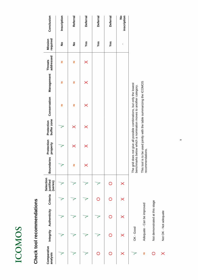
9
Ch
eck
too
l rec
om
men
dat
ion
s
C
om
par
ativ
e an
alys
is
Inte
gri
ty
Au
then
tici
ty
Cri
teri
a
Sel
ecti
on
ju
stif
ied
(s
erie
s)
Bo
un
dar
ies
Pro
tect
ion
p
rop
erty
P
rote
ctio
n
bu
ffer
zo
ne
Co
nse
rva
tio
n
Man
agem
ent
Th
reat
s ad
dre
ssed
M
issi
on
re
qu
ired
C
on
clu
sio
n
√ √
√ √
√ √
√ √
≈ ≈
≈ N
o
Insc
rip
tio
n
√ √
√ √
√ ≈
Х
Х
≈ ≈
≈ N
o
Ref
erra
l
√ √
√ √
√ Х
Х
Х
Х
Х
Х
Y
es
Def
erra
l
O
√ √
O
√
Y
es
Def
erra
l
O
O
O
O
O
Yes
D
efer
ral
Х
Х
Х
Х
Х
- N
o
insc
rip
tio
n
√ O
K -
Goo
d T
he g
rid d
oes
not g
ive
all
pos
sibl
e co
mbi
natio
ns, b
ut o
nly
the
low
est
be
nchm
arks
bel
ow
wh
ich
a n
omin
atio
n m
oves
to a
noth
er c
ateg
ory.
≈ A
deq
uate
- C
an
be im
prov
ed
Thi
s to
ol is
to b
e us
ed jo
intly
with
the
tabl
e su
mm
ariz
ing
the
ICO
MO
S
reco
mm
end
atio
ns.
O
Not
dem
ons
tra
ted
at th
is s
tag
e
Х
Not
OK
- N
ot a
deq
uate

10
11
Cul
tura
l and
Mix
ed P
rope
rtie
s
Su
mm
ary
of
ICO
MO
S R
eco
mm
en
dat
ion
s
Sta
te P
arty
N
ame
of
the
pro
per
ty
Comparative analysis
Integrity
Authenticity
Criteria
Selection justified (series)
Boundaries
Protection property
Protection buffer zone
Conservation
Management
Threats addressed
Mission required
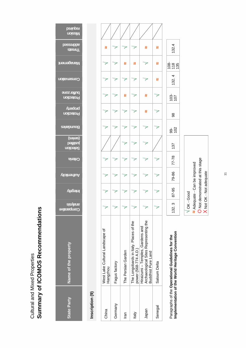
Insc
rip
tio
n (
9)
Chi
na
W
est L
ake
Cul
tura
l Lan
dsca
pe
of
Han
gzho
u
√ √
√ √
√
√ √
√ √
≈
Ger
man
y F
agus
fac
tory
√
√ √
√
√ √
√ √
√ √
Iran
T
he P
ersi
an G
arde
n
√ √
√ √
√ √
√ ≈
√ ≈
√
Ita
ly
The
Lon
goba
rds
in It
aly.
Pla
ces
of th
e po
we
r (5
68-7
74
A.D
.)
√ √
√ √
√ √
√ √
√ ≈
√
Japa
n
Hira
izum
i – T
empl
es, G
arde
ns
and
Arc
hae
olo
gica
l Site
s R
epre
sent
ing
the
Bud
dhi
st P
ure
Lan
d
√ √
√ √
√ √
≈ ≈
√ √
≈
Sen
ega
l S
alo
um D
elta
√
√ √
√
√ √
√ ≈
≈ ≈
Par
agra
phs
of th
e O
per
atio
nal
Gu
idel
ines
fo
r th
e Im
ple
men
tati
on
of
the
Wo
rld
Her
itag
e C
on
ven
tio
n
132.
3
87-9
5
79-8
6
77-7
8
137
99
-10
2
98
103-
107
13
2. 4
10
8-11
8
135
13
2.4
√ O
K -
Goo
d
≈ A
dequ
ate
- C
an b
e im
prov
ed
O N
ot d
emon
stra
ted
at th
is s
tage
Х N
ot O
K -
Not
ade
quat
e
12
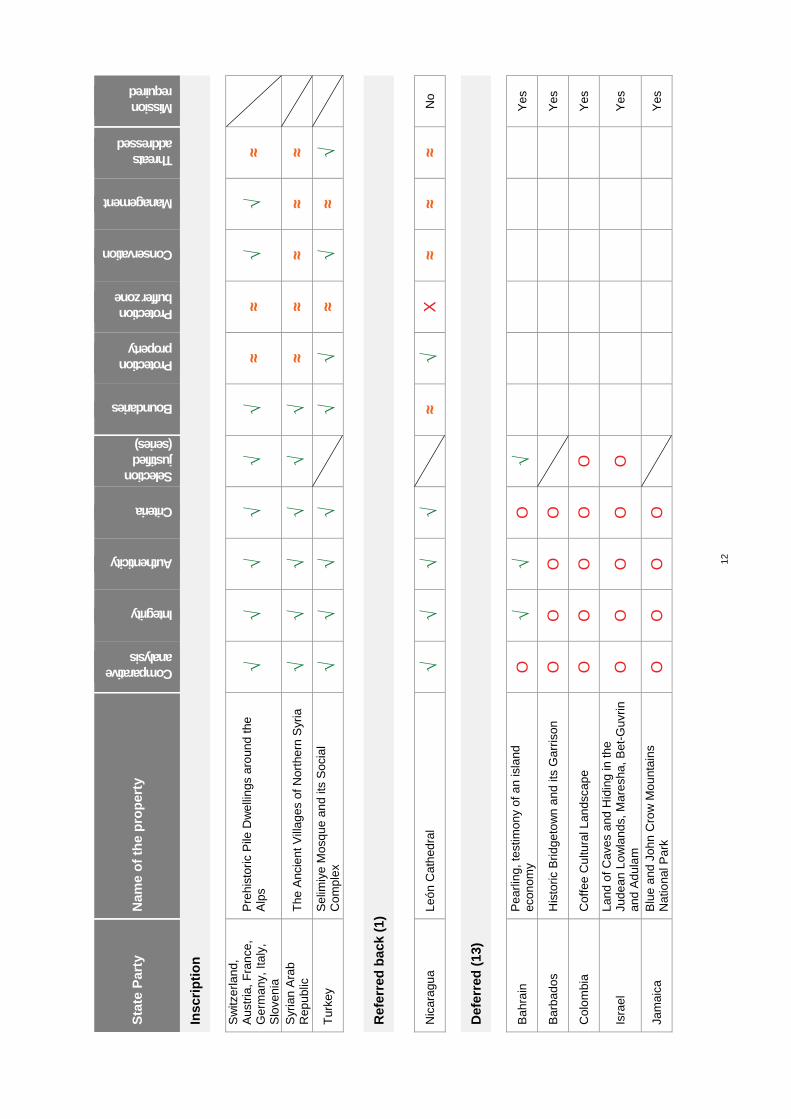
Sta
te P
arty
N
ame
of
the
pro
per
ty
Comparative analysis
Integrity
Authenticity
Criteria
Selection justified (series)
Boundaries
Protection property
Protection buffer zone
Conservation
Management
Threats addressed
Mission required
Insc
rip
tio
n
Sw
itzer
land
, A
ustr
ia, F
ranc
e,
Ger
man
y, I
taly
, S
love
nia
Pre
hist
oric
Pile
Dw
elli
ngs
aro
und
the
Alp
s √
√ √
√ √
√ ≈
≈ √
√ ≈
Syr
ian
Ara
b R
epub
lic
The
Anc
ient
Vill
ages
of N
orth
ern
Syr
ia
√ √
√ √
√ √
≈ ≈
≈ ≈
≈
Tur
key
Sel
imiy
e M
osq
ue a
nd
its S
ocia
l C
ompl
ex
√ √
√ √
√
√ ≈
√ ≈
√
Ref
erre
d b
ack
(1)
Nic
ara
gua
Le
ón
Cat
hed
ral
√ √
√ √
≈
√ Х
≈ ≈
≈ N
o
Def
erre
d (
13)
Bah
rain
P
earli
ng, t
estim
ony
of a
n is
land
ec
onom
y O
√
√ O
√
Yes
Bar
bado
s H
isto
ric B
ridge
tow
n a
nd it
s G
arr
ison
O
O
O
O
Yes
Col
ombi
a
Cof
fee
Cu
ltura
l Lan
dsca
pe
O
O
O
O
O
Y
es
Isra
el
Lan
d of
Cav
es a
nd H
idin
g in
the
Jude
an L
ow
lan
ds, M
ares
ha, B
et-G
uvrin
an
d A
dul
am
O
O
O
O
O
Yes
Jam
aica
B
lue
and
Jo
hn C
row
Mou
ntai
ns
Nat
iona
l Par
k O
O
O
O
Yes
111
Ancient villages of Northern Syria (Syrian Arab Republic) No 1348 Official name as proposed by the State Party The Ancient Villages of Northern Syria Location Governorates of Aleppo and Idleb Provinces of Daret Azza, al-Bara, Maaret an-Nouman, Qalb Loze, Ras al-Hosn and Jisr al-Shoughour Syrian Arab Republic Brief description Located in the vast Limestone Massif in northwest Syria, some forty ancient villages have been selected for the property because of their remarkable state of architectural and landscape preservation. They provide a coherent insight into the rural lifestyles of villagers in late Antiquity and the Byzantine Period. Definitively abandoned in the 8th to 10th centuries, they still retain a large part of their monuments and original buildings: dwellings, pagan temples, churches and Christian sanctuaries, funerary monuments, bathhouses, public buildings, buildings with economic or artisanal purposes, etc. Grouped within eight archaeological parks, the ensemble forms a series of relict cultural landscapes. Category of property In terms of categories of cultural property set out in Article I of the 1972 World Heritage Convention, this is a serial nomination of 8 sites. In terms of the Operational Guidelines for the Implementation of the World Heritage Convention (January 2008), paragraph 47, it is also a cultural landscape, in the organically evolved landscape category and the relict landscape subcategory.
1 Basic data Included in the Tentative List 28 December 2006 International Assistance from the World Heritage Fund for preparing the Nomination 2007 Date received by the World Heritage Centre 29 January 2010 Background This is a new nomination.
Consultations ICOMOS consulted its International Scientific Committees on Archaeological Heritage Management, Historic Towns and Villages, Cultural Landscapes, and several independent experts. Literature consulted (selection) De Vogüé, M., Syrie centrale, Architecture civile et religieuse du Ie au VIIe siècle, 2 vol., Paris, 1865-1867. Green, K.: The archaeology of the Roman economy, University of California Press, 1986. Lavergne, M., « L'urbanisation contemporaine de la Syrie du nord », Revue du monde musulman et de la Méditerranée, n° 62, 1992, p.195-208. Sartre, M., « Villes et villages du Hauran (Syrie) du Ier au IVe siècle », Frezouls E.(éd.), Sociétés urbaines, sociétés rurales dans l'Asie Mineure et la Syrie hellénistiques et romaines, Strasbourg, 1987, p.239-257. Tate, G., Les campagnes de la Syrie du nord du IIe au VIIe siècle : Un exemple d'expansion démographique et économique, Paris, 1992.
Technical Evaluation Mission An ICOMOS technical evaluation mission visited the property from 8 to 15 October 2010. Additional information requested and received from the State Party ICOMOS sent a letter to the State Party on 22 September 2010 and on 28 January 2011 asking for additional information regarding the following:
The comparative analysis; The selection of sites; The current regulatory decisions concerning the
property’s management; The shared management tools and the
establishment of the eight archaeological parks; The protection of the property’s landscape and its
surroundings; Inventories for each of the nominated zones; Major development projects and the possibility of
extending the property to include other sites. The State Party replied with additional information on 24 October 2010 and 16 February 2011. The analysis of this documentation is included in the present report. Date of ICOMOS approval of this report 10 March 2011
2 The property Description In the northwest of Syria, close to the Turkish border, lies a long karstic mountainous region called the “Limestone Massif”. It is approximately one hundred kilometres long and no more than twenty kilometres
112
wide. It is located between the Afrin and Orontes valleys to the west, and the Aleppo and Idleb plains to the east. It forms a folded plateau with an altitude of between 400 and 1,000 metres, its relief marked by several jabals: Sem’an in the north, and Halaqa, Barisha, al-A'la, Doueili, Wastani and Zawiya in the centre and south. They mark the boundaries between the various sectors of the ancient human settlements. The region enjoys a Mediterranean climate, in a mid-altitude mountain location conducive to winter rain. The air is very pure. Easily accessible, it was for a long time a region of just passage or grazing, as its agricultural capacity seemed poor compared with the rich neighbouring plains. The geological and hydrological features of an eroded karstic massif determine the landscape’s natural features, as well as the Mediterranean vegetation of scattered forests and scrubland often transformed into dry steppe following the passage of grazing flocks. This naturally somewhat inhospitable region for humans, abandoned for nearly one thousand years since its occupation in ancient times, has long been called the region of “dead cities”. However, the term is inappropriate as these are remains of villages reflecting slow rural colonisation. They are often ensembles of peasant houses without any precise order and without suitably identified streets or squares. The public buildings are mainly pagan, later Christian, sanctuaries; sometimes there are bathhouses, as well as economic or social venues. In several cases, the urban fabric is more closely interwoven and monumental elements appear, such as towers, more imposing houses, blocks of adjoining buildings, community buildings, etc. The first type of village house (2nd-3rd centuries) is of a unique type that bears no resemblance to the traditional Roman dwelling. Built quite simply in rubble, it consists of a main rectangular, two-storey building. The large ground-floor room, sometimes split into several rooms, is set aside for work activities, storage and animals. The upper storey is reserved for the family dwelling. The rooms open onto a courtyard enclosed by a wall. These are generally living spaces for relatively small groups of people. Sometimes, there are more complex ensembles, with several buildings around a larger courtyard. These include specialist production rooms, monumental entrances or pillared porticoes. The 4th-5th centuries correspond to a population expansion and enrichment of the communities resulting in larger and more refined buildings. These by now include elements inspired by Roman architecture, built to a high level of quality: walls in regular stone masonry, arches with careful finishes, richly-sculpted architectural elements, grand columns, occasionally mosaics, etc. The dwellings often have underground chambers, either under the main building, or under the courtyard. Their role is similar to that of the ground-floor functional and work rooms. The houses sometimes have pillared galleries and they retain stairs providing access to the
upper level. The production buildings are oil mills, mills, presses, etc. The villages were embellished by square towers several stories high, associated with religious buildings. This is the period of Christianisation and the construction of churches, sometimes very large, convents, baptisteries and numerous funerary monuments (hypogea, mausoleums, monumental sarcophagi, etc.). Finally, the villages from this period often have refined buildings for community purposes, not always precisely established even if they are generally designated as inns. They could also be bazaars, shops, farm produce markets or administrative premises. Relatively sophisticated hydraulic elements have been identified, notably large communal cisterns. The use of limestone was encouraged by its omnipresence and by its suitability for use as dressed stone. Its use spread to include numerous elements of the buildings, as wood was a more rare commodity. The unity of material and clearly identified types of construction provide the various villages with a pleasing architectural homogeneity. Farming activity initially involved clearing stones from land designated for crops, followed by the construction of numerous low walls for protection, soil retention and demarcation of plot boundaries in accordance with Roman rules. These low walls marking out the cultivated areas are still very visible in the landscape today. The landscape typologies are analysed from geological and geographic features, the natural plant cover on which was grafted human action in the form of the establishment of the villages, and the improvement of the soil. Four landscape models have been identified, corresponding to the regions of the main jabals: Sem’an, Zawiya, al-A’la and Barisha, and Wastani. This landscape analysis and the visibility limits are used as the basis for defining the property’s eight component sites, based around the selected villages. The first three parks are located in the northern chain of the Jabal Sem’an in the Governorate of Aleppo, whereas the five others are located in the other chains of the Limestone Massif, in the south and west, in the territory of the Governorate of Idleb. Park No 1: Qal’at Sem’an, Jabal Sem’an
The park contains the remains of the great sanctuary dedicated to Saint Simeon the Stylite and his cult, as well as a series of surrounding villages. In particular, the sanctuary includes the large cruciform martyrion church, which was one of the most monumental Christian buildings of its time. In its centre, an octagon surrounds the base of the column at the top of which Saint Simeon spent many years in prayer. It opens onto four lateral basilicas aligned to the cardinal points. The site also includes the remains of a vast baptistery, a monastery adjoining the church and adjacent buildings, and dwellings for those on pilgrimage in the saint’s memory.
113
Among its villages and other remarkable places, Park No 1 includes: Deir Sem’an with its inns, a church and a monastery, as well as a vast three-storey residential building. Qatura provides testimony to a site predating Roman occupation and pagan vestiges. The Sit al-Rum ruins, called “Our Lady of the Byzantines”, with its vestiges of a church and a Roman tomb. Refadeh is a village with very carefully constructed buildings, using both anti-seismic polygonal stonework and horizontal courses. The summit at Sheikh Barakat retains pagan vestiges from the 1st and 2nd centuries, including a temple. Park No 2: the second archaeological park in Jabal Sem’an
This park corresponds to a vast agricultural plateau, more or less continuous, especially in the north, but more uneven in the south. The main sites are: Brad is a large town with characteristic landscapes in the northern part of the plateau. It has a monumental tomb, most likely dating back to the early colonisation, and relatively large baths with a large cistern on an uphill slope. It also has vestiges of Byzantine churches and chapels. Kafr Nabo, to the south, has a pagan temple and a vast inn in fine orthogonal stonework. Borj Haydar, on the summit of a promontory, has a rich religious ensemble with several churches and a convent. An inscription commemorates the land survey of 298. Kalota has some fine houses and two Byzantine churches. Kharab Shams dates from the start of the Roman era, but the village above all has two beautiful churches, 4th and 5th century respectively, the first of which has a colonnaded central nave that is virtually intact.
Park No 3: the third park in Jabal Sem’ane
This park is located in the southern part of the jabal. It has typical Mediterranean vegetation and small olive groves. It is generally used for pasture. The main villages in Park No 3 are: Sinkhar has a dense habitation encompassing the entire period of occupation and provides an illustration of all the regional construction techniques. It also has a church and a chapel, as well as a monumental tomb associated with a dwelling. Batouta is a crest village with five or six large widely-spaced dwellings and the remains of a church.
Sheikh Sliman is a large village in a sparsely populated area, , in the heart of a landscape with clearly visible agricultural plots . It has a large slightly cracked tower and several Byzantine churches. Some of the large houses have been reused in the contemporary era. Park No 4: The first archaeological park in Jabal Zawiya
Jabal Zawiya is the southernmost part of the Limestone Massif. It peaks at an altitude of a little over 1,000 metres. It descends in a steep slope westwards, above the Orontes Valley; but its eastern section has a gently sloping and easily accessible plateau. Its farmland is relatively vast and among the mountainous region’s most fertile. Only the villages in its northern part have been adequately preserved, as the southern part was occupied until the 12th century, at which time an earthquake seriously damaged its built structures. The villages preserved in Park No 4 are close to each other; they form a homogeneous ensemble dating from the Byzantine Period. The main assets are: Serjilla has been known and visited since the 19th century. Arranged on either side of a small valley, the village includes large and very well preserved constructions from the early Byzantine Period, such as an inn and baths; it also contains funerary monuments, large sarcophagi, typical dwellings, a large press, Christian sanctuaries, and an immense communal cistern dug into the rock, etc. Al-Bara is the large town at the centre of all the villages, the many vestiges of which are spread across an extensive area. It is renowned for its 6th century pyramidal tombs, and also has ruins of several churches and three monasteries. Wadi Martaoum has several buildings overlooking a wadi and a series of man-made grottoes. Mujleya is a large agglomeration with dense habitation. It includes two churches, baths and rich tombs. Shinshara has rich houses, the architectural quality of which is very refined. Dallozé is a similar agglomeration comprising an ensemble of fine houses. The other important villages in Park No 4 are Btirsa, Bshilla, Rabi’a and Ba’uda. Park No 5: the second archaeological park in Jabal Zawiya
It is located in the eastern part of the jabal. It has two villages, Rouweyha and Jerada, and the land between them retains exceptional traces of the ancient farm plots across several kilometres. The main elements are: The village of Rouweyha has fine widely-spaced Byzantine houses and a denser residential quarter. It has a large Basilica with a tower and the Byzantine Bizzos Church, named after its founder. It was studied
114
from the 19th century onwards and is considered to be the first (6th century) example of the use of transverse ribs crossing the main nave in order to reinforce it. It also has several tombs, one of which is in the form of a classical temple. The village of Jerada is renowned for its stone tower and 5th century church. The ancient plan of agricultural plots is characterised by relatively low straight walls marking off the plots in extended rectangles. It corresponds to a later reorganisation. Park No 6: Jabal al-A’La
The jabal forms a narrow plateau corresponding to small but numerous areas of settlement. The park’s main elements are: Qalb Loze Basilica (probably dating from the end of the 5th century) is the most important monument in the wholeproperty, after the Saint Simeon Sanctuary. It was described as early as the 19th century. Imposing and well-preserved, it is located within an equally well-preserved enclosure. It includes areas with paved roof terraces and monumental entrances. It is at the heart of a village that was re-occupied from the 10th century and which has experienced recent development. Qirqbizé village is located on a rocky spur, overlooking the plain to the south. It includes dwellings from the end of the Roman era and others from the Byzantine Period, as well as presses. The 4th century church is considered one of the region’s oldest Christian places of worship. It adopts the typical layout of a building with an enclosed courtyard and entrance portico. Kfeir is an isolated village with dwellings from various periods and a richly decorated church. It has many presses one of which is underground. Park No 7: Jabal Barisha
This park has several villages in a characteristic and well-preserved karstic landscape, as the region is virtually uninhabited; it lies close to the Turkish border. The main villages are: Dar Qita was an important village in the Byzantine Period. It has three churches with extensive outbuildings, two baptisteries and towers, as well as around forty houses and a community building. Deiroune has a monastic chapel of rare decorative quality and it is very well preserved. Baqirha is testimony to all the periods of occupation of this region, especially with its 2nd century Roman temple which dominates the village. It has large houses in fine stonework and vestiges of streets with stairs and ramps, as well as two churches. Kherbet al-Khatib has remains of a pagan temple from the 2nd and 3rd centuries as well as a Byzantine basilica with columns and a baptistery.
Park No 8: Jabal Wastani
A majority of the ancient villages in this region were re-occupied. The park corresponds to the northerly part of the jabal, a relatively inaccessible mountainous region. Among the vestiges of dwellings, there are a great many olive and grape presses and numerous cisterns. The most important sites in Park No 8 are: Benasra provides testimony to pagan worship by the ancient Syrian population who cohabited with Christianity: sacred grottoes, a temple and a centre of religious practices. The village has two adjoining churches, built at different periods and with rare architectural details. Al-Fassouq has a building at the highest point of the village. Pre-dating Roman colonisation, it is in part dug out of the rock. The village has dwellings, a subterranean mausoleum and twin churches like in Benasra. Kafr Aqareb has significant buildings, notably a praetorium of the Roman headquarters, a temple and grottoes for pagan worship, a Byzantine basilica and a large communal reservoir on the hill. The surroundings contain vestiges of the Roman road that led to Antioch. The landscapes associated with the village ensembles were formed by the interaction between the farmers of ancient times and their environment. In their synergy with the monumental and archaeological remains, they provide testimonies of complete and well-preserved ensembles. These relict cultural landscapes express the coherency of each of the sites selected as well as the local differentiations. Nonetheless, these landscapes have changed in the course of the occupation of the Limestone Massif, from late Antiquity to the Byzantine Period. This is evident in the architecture, building techniques, the switch from pagan temples on the summits to places of Christian worship in the villages, for the built topography, by the appearance of new types of construction, etc. This is also true of elements of the rural landscape, up until the Roman system of plot parcels that definitively established its relief, but which continued to evolve through the choice of crops, such as the development of olives and grape vines in the Byzantine Period. This is therefore a relict landscape, left exactly as it was after being abandoned in the 8th and 9th centuries. History and development The Limestone Massif in modern northwest Syria was for a long time an area without notable human settlement, especially in protohistoric eras and for a large part of Antiquity. Its karstic mountainous plateau situation with relatively poor stony soils explains its limited or temporary occupation, and use by semi-nomadic herders. Easily accessed, the massif is located close to plains with fertile and easily-worked soil, both to the east and west, which experienced early urban development, sometimes of considerable extent, such as in Antioch, Apamea, Aleppo and Chalcis.
115
The situation changed from the 1st century AD, during the Roman occupation, because of increased demographic pressure and poor farmers searching for vacant land. Human occupation on the limestone plateau began with the clearance of stones from the soil and the building of the first, as yet modest, villages. The period of peace that lasted until the middle of the 3rd century aided regional population expansion, and the migratory movement from the plains increased leading to colonisation of the mountains. It was characterised by growing mastery over the soil, notably by the building of low walls to protect the fields from erosion as much as to mark out their perimeters, giving tangible form to the agricultural plot plan implemented by the Roman administration. A first style of vernacular construction and initial method of farming was established, based on cereals, pulses and stock rearing, as well as fruit trees in some cases. These were relatively poor peasants working under difficult conditions. The temples and tombs illustrate their spiritual and cultural practices. Such a complete ensemble bearing witness to a rural society in Late-Roman Antiquity is rare. The middle and the end of the 3rd century, and the start of the 4th, were marked by epidemics and war against the Persians that led to a decline, or at least a stagnation, in the rural colonisation of the Limestone Massif. New constructions become rare. This was a period of transition. The situation started to change in the 330’s, with a return to population growth. Lasting peace was established under the new Eastern Empire that arose at the end of the 4th century. This period of expansion lasted for nearly two centuries during which time the mountain population grew threefold or more. The economic recovery was both quantitative and qualitative, with improved control of water, and development of grape vines, olive and fruit trees. The production of oil, fruit and wine made the villages richer and led to a long-lasting high-point for architecture. While the basic model of Roman building was used, notably for the style of farm house specific to this region, it was enlarged, diversified, built to a far higher standard in regular stone masonry, and refined ornamentation was added. The quality of the limestone made possible such architectural development combined with a real passion for stone in the rural environment. The mountain society belonged to two cultures expressed through the use of two languages: Syriac (or Aramaic), the native language, and Greek as demonstrated by the great many inscriptions. This society gradually converted to Christianity under the influence of hermits during the 4th and 5th centuries, even though pagan rites continued. Religious architecture (churches, convents, baptisteries and tombs) took on considerable importance, resulting in particularly refined, and at times vast and original, buildings. During this period, Saint Simeon was an extremely famous Christian ascetic from the region. He spent a large part of his life at the top of a column, in Jabal Sem’an (Simeon
Mountain), where he prayed and converted crowds of pilgrims who had come to meet him. After his death in 459, a vast sanctuary ordered by Emperor Zeno was built around the base of his column (Park No 1). The villages built increasingly large churches, and in greater number, from the end of the 5th century and during the 6th century. A powerful monastic movement developed in the wake of the saints and hermits. This period of expansion and wealth in the mountains finally came to an end in the mid-6th century. Construction declined and then ceased altogether. Food shortages and epidemics again became rife, as during the Persian War, affecting the entire Syrian territory. A discrepancy grew between an ever-increasing population and stagnating resources within a territory that it was impossible to enlarge. The rural population grew poorer and increasingly weak, leading to a migratory movement back to the neighbouring plains and their towns from whence their remote ancestors had come. The Arab Islamic Conquest (7th century) did not directly affect the region, but it did reinforce the migratory trend that became massive in the 8th and 9th centuries. The plateau was emptied of its population; the farmland and villages were gradually abandoned. In the 10th century, the mountains were deserted. The difficult conditions for working the land and managing water meant that there was no major attempt to re-establish agriculture in the limestone mountains in the following centuries. There were a few exceptions to this, and above all a recent movement to re-establish agriculture under the influence of regional demographic growth. This affects a large number of villages, some of which are within the property’s boundaries.
3 Outstanding Universal Value, integrity and authenticity
Comparative analysis The comparative analysis proposed by the State Party encompasses three complementary approaches: at the national level, by examining properties from the same period; in the Mediterranean Basin and in similar historic and cultural contexts; and lastly by a review of properties already inscribed on the World Heritage List, in the Mediterranean Basin and the Middle East for which there is a certain analogy. In Syria, there are many and often remarkable monuments and archaeological sites dating from the Roman and Byzantine Periods. However, they are frequently associated with monumental or urban ensembles that were re-used and rebuilt in later periods. Unity between the built and natural environment is rarely as significant and the testimonies are of a different nature. Sites similar to the nominated property must be looked for in areas at the edges of the great axes of human occupation in these periods. This is the case with villages in southern Syria that provide notable similarities in terms of occupation of a rural territory and types of
116
construction. However, this region is geologically different and was re-occupied starting from the 17th century, resulting in extensive transformations. Testimonies comparable to the property are therefore more disparate and they are in environments with less integrity and authenticity. Whilst rural society of Roman and the early Byzantine Period both had a profound effect on the history and landscape of the Mediterranean Rim, their built testimonies have often been modified or destroyed by the civilisations which came after them. There are, of course, very important architectural vestiges, both religious and urban, but, as is the case in Syria, complete sites that are the most similar to the property must be sought in isolated or marginal rural areas. The mountainous regions close to southern Turkey and Palestine provide examples of rural houses, ancient villages and landscapes sharing similarities with the property, but their scope, stylistic unity and preservation are far less great. The site of Dougga / Thugga and its landscape in Tunisia (1997, criteria (ii) and (iii)) is the most similar but it is a single isolated city and not a regional ensemble. The case of Incense Route – Desert Cities in the Negev, Israel (2005, criteria (iii) and (v)), offers a similar level of preservation because of early abandonment, but the testimony is different, referring to trade on the Incense Route. Also, in plains’ regions, mud brick, a degradable material, was often used for rural constructions, as in the Nile Delta, and few traces have remained despite extensive historical presence in the same periods. Several sites in the Mediterranean Basin and the Middle East testifying to late Antiquity and early Christianity have already been inscribed on the World Heritage List. There is, however, no recognised Byzantine site in Syria so far, whereas it is a very important aspect of the history of this country and region. The closest property of this type is Saint Catherine Area in Egypt (2002, criteria (i), (iii), (iv) and (vi)), in use to this day, providing a very important testimony to 6th century Christian architecture. It may be compared to Saint Simeon Sanctuary, but the latter is an archaeological site. Again in Egypt, the paleo-Christian town of Abu Mena (1979, criterion (iv)) provides an example of urban and architectural development paralleling that in the region of the ancient villages of northern Syria. It also contains an important sanctuary associated with a pilgrimage. In Jordan, Um er-Rasas (2004, criteria (i), (iv) and (vi)) has a similar history, testifying to the region’s architectural and urban history in the same periods as those of the nominated property. The major presence of anchorite monks underscores the analogy. Nonetheless, the vestiges also date from the Umayyad period and they are more fragmented in terms of agriculture. Elsewhere in the Mediterranean Rim, inscribed properties demonstrating significant similarities are, firstly, Göreme National Park and the Rock Sites of Cappadocia, Turkey (1985, criteria (i), (iii), (v) and (vii)). This site provides an exceptional testimony to Byzantine
Christian culture that nonetheless includes a much later phase, and the subterranean nature of the site and its associated landscapes are unique and dissimilar to the nominated property. Early Christian Monuments of Ravenna, Italy (1996, criteria (i), (ii), (iii) and (iv)) illustrates in a remarkable and very comprehensive manner the architectural and decorative transition between the Roman world and Byzantine influence in Southern Europe. A certain number of elements are specific to this property, but the development, in the same period, of Saint Simeon Sanctuary, the basilicas and the first monasteries in the property provide an Eastern counterpoint to the Ravenna site. Other monastic properties present similarities: Meteora, Greece (1988, criteria (i), (ii), (iv), (v) and (vii)) also had anchorite monks, but at a much later period and in a spiritual context in a spectacular and isolated mountainous environment. The Armenian monasteries and their churches also provide similarities, especially Monastery of Geghard and the Upper Azat Valley, Armenia (2000, criterion (ii)) and the Armenian Monastic Ensembles of Iran (2008, criteria (ii), (iii) and (iv)). These are exceptional sites but purely devoted to monastic and spiritual activity, in a defensive fortified context which differs from that of the ancient villages of northern Syria. The theme of agro-pastoral landscapes is also evoked, but it is considered removed from the property’s values, as it is only a late and secondary aspect of its history. ICOMOS considers that the State Party presents a detailed comparative study bringing the property’s specific values and its landscapes into relevant perspective. The analogies and differences are well set out. In terms of ancient agricultural plot plans, the remarkable case of Stari Grad Plain, Croatia (2008, criteria (ii), (iii) and (v)) might also be evoked, dating from a more ancient Greek period. In conclusion, the nominated relict cultural landscapes form a diversified and very complete testimony of rural development in the Roman Empire, and the initial phases of the Byzantine Empire, in the form of its villages, dwellings, economic structures, agricultural plot plan, pagan and then Christian places of worship, funerary monuments, etc. It appears to be unique in terms of its extent, completeness and conservation. ICOMOS considers that the comparative analysis justifies the choice of the sites constituting the serial property proposed for the World Heritage List.
ICOMOS considers that the comparative analysis justifies consideration of this property for the World Heritage List.
Justification of Outstanding Universal Value The nominated property is considered by the State Party to be of Outstanding Universal Value as a cultural property for the following reasons:
117
The eight sites selected provide remarkable, complete testimony of rural colonisation in late Antiquity and the early Byzantine Period, and its interaction with its environment. They have resulted in relict cultural landscapes characteristic of this rural colonisation and its cultural evolutions, both material and spiritual.
The sites illustrate the development of farming communities in a Mediterranean mountainous zone of medium altitude, from the 1st century to the 6th century, in terms of its dwellings, villages and a clearly identifiable agricultural plot plan. It is an exceptional testimony in terms of its extent as well as its diversity and quality.
Amongst the many architectural remains, the churches, monasteries, funerary monuments and places of pilgrimage testify to the birth and development of the Christian world in the countryside of the Middle East.
The exceptional state of preservation of the built remains and landscapes is attributable to the quality of the stone constructions, both monumental and vernacular, and by the abandonment of the limestone mountain regions of northern Syria for a thousand years.
The eight parks forming the nominated serial property correspond to the selection of the best preserved villages and monumental sites. They form, with their environments, coherent ensembles and characteristic landscapes. ICOMOS considers that the arguments put forward by the State Party are justified. This is indeed a strong testimony, of remarkable quality, of the lifestyles in the countryside during the Roman Empire and the Byzantine Empire that followed, from the 1st to the 6th century. It is also an important illustration of the development of Christianity in the East, within village communities. The notion of relict cultural landscape is fully justified. Integrity and authenticity Integrity
The notion of integrity applies on the one hand to the built remains and on the other to the cultural landscapes of the serial property. Although only representing 5 to 6% of the Massif, the surface area of the eight parks is 130 km2 and they encompass the entire architectural diversity of the monuments and vernacular constructions from the various periods, as well as extensive overviews of the ancient agricultural plot plan. The same applies to the diversity of the landscapes associated with the historical development of the village communities. When the Limestone Massif is abandoned, the hitherto living landscapes become relicts. However, the plant cover evolves, and the Massif is returned simultaneously to nature and extensive semi-nomadic stock activities.
The very recent return of village communities is tending to re-open the living dimension of certain rural landscapes of the Massif through, for the time being, traditional activities with limited mechanisation. The nominated property’s sites are only slightly affected by this phenomenon. ICOMOS considers that the architectural integrity of the property’s sites is adequately expressed and that it is very complete. The sites are sufficiently extensive; they include a large number of villages, places of worship, and well-chosen monumental and vernacular testimonies. The number and quality of relict landscapes is also adequate. The ensemble selected adequately expresses the values and meanings associated with the property’s history. However, the recent trend towards agricultural re-occupation of the Limestone Massif could affect the integrity of the built component of certain villages, and their associated landscapes. ICOMOS considers that the nominated series is fully justified and that it is adequate to express the property’s values. ICOMOS considers that the series is closed. Authenticity
The almost total absence of human occupation over the centuries that followed the abandonment of rural settlements, in the 8th and 9th centuries, coupled with the quality of the constructions, explains the remarkable state of preservation of a large number of villages, places of worship, and the surrounding rural and natural landscapes. In the eight sites selected, the topography of human settlement, the architectural forms and designs, and the materials used have remained intact. Their level of preservation allows them to express very fluently the occupants’ functions, usages, technical practices and lifestyle. The property’s location, well removed from the main areas of development, has enabled it to avoid, on the one hand, re-use of the stone that happened so frequently in urban areas and, on the other hand, the sometimes untimely restoration/reconstruction campaigns at some ancient and medieval properties in the 20th century. Furthermore, its most important monuments are well known through the architectural descriptions made by travellers and archaeologists from the middle of the 19th century. The main human intervention, other than rural re-settlement, affecting the property is archaeological excavation that tended to become more frequent in the second half of the 20th century. They are in general respectful of the sites and contribute to the understanding of the authenticity of the components. In its reply to the September 2010 request by ICOMOS, the State Party indicated that more than 700 ancient sites have been recorded in the Limestone Massif region, and some sixty are deemed to be in a good state of preservation, without or virtually without any human
118
impact since their ancient use. The forty most significant, and having the most satisfactory landscape environment, have served as the basis for defining the property’s sites. With their territories encompassing important vestiges of the ancient Roman rural plot plan, the villages are grouped into eight clearly identified landscape areas, each forming an archaeological park. The ensemble forms the serial property. ICOMOS considers that as a result of the absence of human occupation for one thousand years, the absence of re-use of the stones and the absence of restoration/reconstruction campaigns in the 20th century, the property and its landscapes have retained a very high degree of authenticity. However, recent rural settlement could affect the conditions of authenticity, in terms of the buildings, structure of the villages and the landscapes. Furthermore, well managed and traditional replanting, respectful of the ancient plot plan, should contribute to revitalising the landscape without affecting its authenticity.
ICOMOS considers that the conditions of integrity and authenticity have been met.
Criteria under which inscription is proposed The property is nominated on the basis of cultural criteria (iii), (iv) and (v). Criterion (iii): bear a unique or at least exceptional testimony to a cultural tradition or to a civilization which is living or which has disappeared;
This criterion is justified by the State Party on the grounds that the serial property provides a unique and exceptional testimony to the lifestyles, rural development and cultural traditions established during the colonisation of the Limestone Massif of northern Syria, during the Imperial Roman period and early Byzantine Empire. This culture is characteristic of a successful and sustainable agricultural system, in a karstic plateau region that is difficult to work. It was in particular based on wheat, vines and olives. It developed a characteristic system of stone habitations appropriate to the region’s economic development. It is a testimony at a regional scale and of a rare quality. ICOMOS considers that the serial property provides a homogeneous and exceptional testimony to the lifestyles and cultural traditions of rural civilisations that developed in the Middle East within the context of a Mediterranean climate at mid-range altitudes from the 1st to the 7th century.
ICOMOS considers that this criterion has been justified.
Criterion (iv): be an outstanding example of a type of building, architectural or technological ensemble or landscape which illustrates (a) significant stage(s) in human history;
This criterion is justified by the State Party on the grounds that the forty villages in the eight archaeological parks form a unique ensemble of built remains. In the context of the Mediterranean Basin, they testify to the evolution of rural domestic architecture during late Antiquity and the Byzantine Period. They testify to a well established type of construction for rural habitats in these periods. The region gradually shifted from the pagan worship of late Antiquity to Christianity, as demonstrated by an exceptional ensemble of temples, churches, baptisteries, tombs, and places of worship and pilgrimage. Their architectural styles and their locations illustrate the transition between the values of the Classical Roman world and the spread of Byzantine Christianity in the 4th-6th centuries. The eminent quality of the property’s constructions is illustrated by the mastery of stone masonry, used in particular during the Byzantine Period, both for vernacular housing and community buildings and places of worship. The refinement of the sculpted decoration combined with the creative architectural traditions reveal a remarkable mastery of stonework and a style characteristic of a cultural and spiritual peak. ICOMOS considers that the serial property provides an ensemble of eminent examples both of the architecture of rural houses and civilian and religious community buildings at the end of Classical Antiquity and during the Byzantine Period. Their association within villages and places of worship forms relict landscapes characteristic of the transition between the ancient pagan world and Byzantine Christianity.
ICOMOS considers that this criterion has been justified.
Criterion (v): be an outstanding example of a traditional human settlement, land-use, or sea-use which is representative of a culture (or cultures), or human interaction with the environment especially when it has become vulnerable under the impact of irreversible change;
This criterion is justified by the State Party on the grounds that the serial property presents remarkably preserved landscapes that illustrate human settlement and the utilisation of the territory of the Limestone Massif of northern Syria, from Roman Antiquity to the Byzantine Period. These landscapes illustrate a rational and systematic occupation of the land by clearing the soil of rocks, building low protective walls, establishing the agricultural plot plan in the Roman Era, and the selection of appropriate and exportable agricultural crops (wheat, oil and wine). The rural dwelling expresses a functional type adapted to these economic activities and their use by groups of farming families. In an unfavourable karstic environment, the collection of water and its storage in at times very large cisterns shows a high level of skill in hydraulic engineering.
119
ICOMOS considers that the property provides an eminent and significant example of a sustainable rural settlement, from late Antiquity to the early Byzantine Period. It is based on the careful use of soil, water and limestone resources, as well as the mastery of agricultural production and its transformation into products of value. The economic function of the habitat, the hydraulic techniques, protective walls and Roman agricultural plot plan inscribed in the landscape are testimony to this.
ICOMOS considers that this criterion has been justified.
ICOMOS considers that the serial approach is justified and that the selection of sites is appropriate.
ICOMOS considers that the nominated property meets criteria (iii), (iv) and (v) and conditions of authenticity and integrity and that Outstanding Universal Value has been demonstrated.
Description of the attributes In terms of its characteristic relict landscapes, the
serial property provides an exceptional testimony of rural colonisation in late Antiquity and the early Byzantine Period. It illustrates the dense network of villages created by the communities and their interaction with the environment.
The technical expertise associated with this rural settlement is in particular expressed through domestic architecture, its enclosure and functional distribution of the rooms. It forms a type of construction that is well-established, the evolution of which can be traced through history.
The large cisterns are testimony to mastery over water management; low walls were used for soil improvement and protection and they marked out the ancient agricultural plot plan.
The temples, basilicas, churches, baptisteries, monasteries, funerary monuments and places of pilgrimage reflect ancient paganism followed by the birth and growth of Christianity in the Middle Eastern countryside.
The structure of the villages is generally loose, but it is arranged around numerous religious buildings, especially churches, and includes civilian community buildings.
The remarkable quality of construction, the mastery and general use of stone masonry in the Byzantine Period, and the refinement of the sculpted decoration are testimony to a creative architectural tradition; they express a style that is characteristic of a society at its cultural and spiritual peak.
4 Factors affecting the property Development pressures
Long abandoned, the Limestone Massif has seen an extensive revival of rural and village life since the 1980s. Despite the past protection of the most emblematic places and historic monuments, and a choice of sites that has taken this factor into account, several villages in the nominated property are affected by this trend. ICOMOS notes that disorganised growth of small settlements could rapidly have a negative impact on the property’s landscape and conservation. It has been announced that a housing development project by a large property company within the boundary of Park No 3, not far from the major archaeological site of Sinkhar, was stopped at the last moment. This trend is accompanied by a revival in farming the land. For the time being, it is not very mechanised and is tending to reintroduce species that belong to this ancient rural landscape, such as olive trees. However, there is a growing trend towards the use of large machines to remove the stones from the soil and destroy the ancient low walls to increase the size of fields and open up pathways. The ancient remains are open to the risk of vandalism and theft, notably the reuse of the dressed ashlar stone or for the illegal trade in sculpted stones. There is also the possibility of unauthorised excavations at the most remote archaeological sites to dig up artefacts for sale on the international antiquities market. A programme for the installation of power lines could affect Park No 1. In the Jabal Zawiya area (Park No 5), there are projects to develop limestone quarries and industrial projects that have not taken into account the property’s landscape dimension. Tourism pressures
Apart from the Saint Simeon Sanctuary, the sites are infrequently or not at all visited. Tourism does not pose any notable problem and, for the State Party, its increase should be very gradual and controlled in the event that the property is inscribed on the World Heritage List. Environmental pressures
The eight archaeological parks that make up the property are characterised by a fine natural environment with an excellent atmospheric quality that have been well preserved up until now. For the State Party, there is no pressure in this area for the foreseeable medium term.
120
Natural disasters
The property is located in a seismic zone, as evidenced by the many accounts of earthquakes in historic sources. Their effects are sometimes visible in the property’s built remains. The risk of fire relates to rural vegetation in the dry season. Impact of climate change
For the time being, there is no fully demonstrated effect from climate change on the property.
ICOMOS considers that the main threats to the property are human intervention through inappropriate agricultural methods, construction near the sites, the reuse of antique dressed stone and unauthorised excavations. The erection of power lines could affect the area of Saint Simeon Sanctuary (Park No 1) and a plan to open a quarry and establish industrial activities could affect Jabal Zawiya (Park No 5).
5 Protection, conservation and management
Boundaries of the nominated property and buffer zone The State Party above all considers each of the property’s sites as a cultural landscape, that is, an ensemble of highly correlated constituent elements expressing an overall value. The definition of each site is dependent on this: it is determined from the identification of the most significant villages, monuments, and vestiges of the agricultural plot plan combined with the best preserved natural environments. Eight separate landscape areas have been identified, taking into account the visual boundaries created by crest lines and the horizon at each of the sites. In each case, they are relatively large areas with precise boundaries, even if these are not always identified with markers. This global approach views each site as a visual territory taken as a whole and defined as a relict landscape. The ensemble forms a series of relatively large geographic basins that always define the visitor’s view. This approach to defining the landscape sites has led the State Party to not consider a buffer zone. Each of the property’s eight territories has been named an archaeological park.
Archaeological park number
Surface area (ha)
Population (2009)
Inhabited villages (2009)
1 3,700 1,650 1 2 2,760 3,872 4 3 380 1,200 1 4 3,200 1,500 1 5 530 1,900 2 6 460 1,500 1 7 580 0 0
8 680 150 2 Totals 12,290 11,772 12 (out of 40)
ICOMOS considers that the boundaries of the nominated property are adequate and that the absence of a buffer zone has been justified.
Ownership Ownership of the plots of land within the boundaries of the archaeological parks that form the property of the Ancient Villages of Northern Syria is both public and private, with the relative ratios varying between parks. Public ownership is of two types. The monuments, churches, listed dwellings, archaeological sites, etc., are generally owned by the Ministry of Culture. The second type of public ownership is exercised by the Ministry of Agriculture, generally in the form of land reserves, sometimes in areas of low heritage value. Private ownership is generally linked to family homes and farmed plots of land. However, a large part of Park No 3 is reported to have been bought by a company for a housing programme (see threats). The State Party has, however, indicated that this entire site has been declared a no-construction zone. In most cases, there is no survey plan on which to record the properties. The creation of precise and reliable plans of the areas has been in progress since 2006 under the responsibility of Idleb and Aleppo governorates, in liaison with the Directorate General of Antiquities and Museums (DGAM). This is a priority for implementing the protection of the parks. ICOMOS encourages the State Party to complete the survey of each site as quickly as possible, with the official input of the Directorate General of Antiquities and Museums (DGAM). The complete ban on the building project within Park No 3 must be confirmed. Protection Legal protection
The protection of cultural heritage is the responsibility of the Ministry of Culture aided by the Council of Antiquities of the Directorate General of Antiquities and Museums (DGAM). All monuments and archaeological sites older than 200 years come under the Antiquities Law (No 222, 1963, revised 1974 and 1999). The DGAM defines the sites that form the national heritage and which must be protected by being officially inscribed on the Register of Archaeological Sites and Monuments. It obliges municipalities to make provision for their conservation in local development plans and land surveys. It makes provision for prohibiting construction and works within a 500 metre perimeter, as well any restoration under the control of the DGAM.
121
The listing of the property’s first monuments began in 1937. At present (2008), 36 archaeological sites in the property, corresponding to the main villages and most important monuments, are protected by the Antiquities Law. The Antiquities Law is augmented by various texts and regulations concerning the protection of heritage property, jointly by the Ministry of Culture (DGAM) and local authorities, notably with regard to illegal construction. The other main national laws applicable to the property are: The Civil Code and Punishment Law (No 148, 1949), The Municipal Management and Administration Law
(No 12, 1971, revised in 2003, Law No 15), The Laws on Urban Sites (1974), The Forest and Environmental Protection Decree
(No 25, April 2007), The Regional Planning Law (No 26, June 2010) must
enable inscription of the property within the context of a broader regional plan.
The recent decisions concerning the property’s new management structure are: Ministerial Decrees (Prime Minister) for the creation
of the eight archaeological parks (No 52/A to 59/A, 31 January 2010),
Ministerial Decision (Culture) for the creation of the two Park Management Centres (336/A, 29 July 2010).
Decree for the creation of La Maison du Patrimoine (26 August 2010).
The State Party is aware of the absence of legal protection of the cultural landscapes, essential in this instance. Consequently, discussions are in progress to revise the Antiquities Law to take this into account. However, it is a process that involves a certain amount of time and which must involve the local communities and take into account the new Regional Planning Law (June 2010). Consequently, a Decree by the President of the Council of Ministers (January 2010) has enabled the creation of the eight parks defining the nominated property and provides temporary protection of the landscapes. In practice, protection is provided by the official guards, of whom there are about twenty (2008). Three of the sites are under permanent surveillance; for the others surveillance is in the form of regular patrols. Traditional protection
A programme to raise awareness among the population living within the boundaries of the property’s parks has been introduced.
Effectiveness of protection measures
ICOMOS considers that the legal protection in place is extensive and rapidly evolving, notably in the direction of regional planning and protection of the property’s cultural landscapes. The relevant revision announced to the Antiquities Law is encouraged. The number of guards needs to be increased for those parks with the least supervision or most exposed to illegal activities.
In conclusion, ICOMOS considers that the legal protection dynamic is heading in the right direction and that it must be confirmed by the revision of the Antiquities Law.
Conservation Inventories, recording, research
The data concerning the inventory for the archaeological sites of the Limestone Massif is held by the DGAM in Damascus. The conservation and management of this data is being modernised in order to prepare an archaeological map of the Limestone Massif by the DGAM jointly with the Syrian-French Archaeological Mission. The architecture of the ancient remains in northern Syria has been studied since the 19th century, and is well known through numerous publications together with site documentaries in the form of maps, measurements, inventories, photographs, etc. Current archaeological and historical research on the sites is conducted by the DGAM with extensive international scientific cooperation. Research is currently being intensified by means of 3-D digital recordings of the most important buildings, and biochemical analysis of organic debris. Present state of conservation
The state of conservation of the natural and cultural landscape is considered very satisfactory by the State Party. The revival of agricultural activity in many places, using traditional methods, has had a positive impact on the maintenance and regeneration of the landscapes. Activities that are relatively incompatible with the conservation of the landscapes occur outside the park boundaries. The inventory of the state of conservation of the landscapes reveals that some changes have occurred: some non-compliant reforestation, the existence of an industrial chicken farm, several instances of stone removal using a bulldozer, and alterations to the walls of the agricultural plot plans by farmers. These are, however, limited in scope. The main alterations to the built vestiges are attributable to the illegal human actions mentioned above: unauthorised construction, vandalism, re-use of the stones, theft of sculpted elements, etc.
122
The blocks of limestone which are exposed to damp rising through the soil are affected and may be subject to deterioration. The sculpted elements are equally exposed to the effects of natural degradation, such as salt crystallisation. Active Conservation measures
The conservation of the landscapes is a global and permanent process, expressed, on the one hand, by the application of protective measures and the active role of the guards and, on the other, by the implementation of an information and consultation policy involving the property’s inhabitants to raise awareness of its values and how best to conserve them. The Maison du patrimoine (2 locations) should encourage good practices compatible with sustainable and controlled economic development. For the moment, there is no current or projected work to consolidate or restore the monumental elements. However, timely work has been carried out in the past in some instances, such as in Qalb Loze, Saint Simeon Sanctuary and more recently in Serjilla. An expert evaluation of stone disease from rising damp is currently being carried out, and ICOMOS notes that a drainage programme for the most affected areas will be implemented. Maintenance
The maintenance of the three archaeological sites which have permanent guards and are open to controlled visits (Saint Simeon Sanctuary, Park No 1, Serjilla, Park No 4 and Qalb Loze, Park No 6) is provided by the guards and employees allocated to these sites. Under the application of the Antiquities Law, the other sites are maintained by the municipalities. Farmers contribute to the maintenance of the landscapes insofar as they adopt relatively non-mechanised practices that are respectful of the ancient agricultural plot plan. Effectiveness of conservation measures
ICOMOS considers that the current state of conservation of the landscape and the archaeological sites is good, but that this situation may be weakened in the future, notably from growing development pressure. These are large open sites with recent rural populations within their perimeter and margins, looking for legitimate income. The overall actions involving this population are important for reinforcing conservation effectiveness. They need to target both the protection of the sites and an information policy regarding conservation issues and the population’s involvement in these areas.
ICOMOS considers that the property’s state of conservation is adequate. While the conservation of the archaeological remains is assured overall, that of the
landscapes is only just beginning and it could be weakened by growing development pressure.
Management Management structures and processes, including traditional management processes
The general body currently responsible for the property’s management, both for scientific projects and the practical management, is the Directorate General for Antiquities and Museums (DGAM), located in Damascus and reporting directly to the Ministry of Culture. It is providing for the creation of a specialist department for monitoring sites inscribed on the World Heritage List. It has three local offices in charge of the protection and monitoring of the property’s archaeological sites. The Ministry of Tourism is in charge of drawing up the tourism management plan for the property. Aleppo and Idleb governorates represent the State and its services in the region. The municipalities operate under each governorate and under the responsibility of the Ministry of Local Affairs; they are responsible for managing those sites not directly controlled by the DGAM, developing local infrastructure and controlling construction and works. With its starting point a management structure historically highly centralised at the national level, an effort is being made, within the context of the inscription dossier, to decentralise operations towards local structures and encourage action within the sites themselves. A certain number of responsibilities are being transferred to the regional authorities, municipalities, and management authorities which are currently being established (park, Maison du patrimoine and management centres). The creation of the eight archaeological parks (January 2010) corresponds exactly to the property’s eight landscape territories. It aims to develop local management and conservation compatible with the objectives of sustainable development that is respectful of the property’s values. The final structure for coordinating management of the parks is based in a Maison du patrimoine, which is an autonomous legal entity with a local office in each of the two governorates. Currently being set up, it will be responsible for coordinating all projects concerning the conservation, monitoring and promotion of the parks. It will include: At the executive level, the Maison du patrimoine will
coordinate the management of the parks with all the parties involved, under the responsibility of the governors and the DGAM; its responsibilities will be broader than those currently exercised by the DGAM’s local offices; it will eventually be invested with significant powers of action.
123
The two Maison du patrimoine offices each form a property management centre in each of the governorates.
The Maison du patrimoine Steering Committee will include representatives of the main stakeholders in the property’s conservation and management. In particular, it will be in charge of defining and monitoring the protection and conservation of the sites and landscapes.
A National Inter-Ministerial Committee will form the senior level of coordination and control.
ICOMOS considers that the property’s management is currently provided by the DGAM (2009-2010), but on a transitional basis. The property’s final management structure will include the eight parks associated with each of the sites, a management centre in each of the two governorates, and the Maison du patrimoine to manage the ensemble and coordinate conservation, under the authority of the DGAM, the Ministry of Tourism and the provincial governors. The additional information provided by the State Party shows that the new management structure has effectively been in place since summer 2010. ICOMOS encourages this implementation, which must benefit from the human and material resources required for its effective operation. Policy framework: management plans and arrangements, including visitor management and presentation
The Management Plan incorporates general management objectives for the property and its landscapes, as well as the data needed to establish the new management system. An Action Plan (December 2010) has been created for its implementation. In structural terms, the objectives are to: Reinforce or establish management of each of the
parks and create their management centre, Define the overall mechanisms and management
coordination for the serial property, by creating the Maison du patrimoine,
Define the missions of the Maison du patrimoine along with the professional expertise required for their implementation,
Create a process for the regular evaluation of the measures implemented and their outcomes.
In terms of the property’s conservation and tourism development, the objectives mainly aim to: Define and plan with the relevant municipalities the
protection and conservation of the ancient villages, Define and plan with the relevant municipalities the
principles for landscape development and conservation,
Support scientific research in the areas of archaeology and architecture, coordinate excavations and the actions of international archaeological missions,
Prepare the archaeological maps of the eight parks, Develop a coordinated communication, promotion
and tourism strategy between the various parks by writing a Tourism Development Plan.
The Management Plan aims to promote sustainable local development compatible with the conservation of the property’s values and its landscapes, notably by: Improving the standard of living of the inhabitants by
developing cultural tourism in small private tourism service entities,
Overseeing and assisting sustainable rural development and reasonable exploitation from quarrying,
Coordinating and ensuring the application of town planning regulations,
Coordinating infrastructure within the sites (paths, roads, electricity, etc.).
Additionally, the property Management Plan must take into account a series of other local, regional and national plans and programmes: Priority national development plans: no heavy
transport infrastructure is planned within the region of the serial property,
The Ministry of Tourism’s development plans that affect the sites (Park No 2),
The local industrial development programme near the village of Jerada in Park No 5 (Jabal Zawiya),
Idleb Governorate’s digitised land survey programme.
DGAM also coordinates various projects or programmes in partnership with other entities: The current project for the area of Saint Simeon
Sanctuary by the Arab Fund for Economic and Social Development;
The project for hiking tracks and cultural promotion in Jabal Sem’an with the Swiss Agency for Development and Cooperation, completed in 2007;
The relocation and revision of the Sinkhar property development project by the Engineers Union in Aleppo.
ICOMOS considers that the property Management Plan includes both a review of the relatively diverse actions implemented to date and a general project for the future management of the sites, notably the Action Plan included in the additional documentation (December 2010). Given the recent or current implementation of the bodies responsible for the property’s management (parks, management centres and Maison du patrimoine), there is a risk of project diffusion or initiatives that are not in accordance with the correct conservation of the property and its landscapes. During the transition period, the DGAM’s capacity for control over the property’s management should be maintained. The Management Plan and the Action Plan need to be rapidly finalised with
124
a schedule of actions and their implementation timeframes. Risk preparedness
In the event of forest fires, there are emergency plans for each of the sites and their regions, with a network of access trails and firebreaks. Visitor safety, notably with regard to falling stones, is included in the Management Plan. The management centres (Maison du patrimoine) will be responsible for compiling a risk management plan. Involvement of the local communities
The local communities are involved in the studies, definition and establishment of the boundaries of the serial property. It is planned that the Maison du patrimoine will play an important role in raising awareness and support among the region’s population in the areas of architecture, agriculture and tourism. Resources, including staffing levels, expertise and training
The personnel involved in the conservation and management of the nominated property are at present (January 2010) only those employed by the DGAM: in its central services in Damascus, in three regional offices and onsite. It seems that the number of people effectively available for looking after the property is limited, or that they devote only part of their time to it, in Damascus notably (2 architects, 1 engineer and 1 heritage conservator). The DGAM’s local offices employ architects and engineers (5), technicians (5), survey staff (8), inspectors (around 30) and administrative staff (around 10). Here again, they do not all work full-time on the nominated property, as they often have other tasks to perform. The site guards (around 20) or museum employees (around 10) are the field staff allocated full-time to the sites. The recruitment of an additional ten guards is scheduled for the period 2009-2010. The State Party makes a critical analysis of this data, concluding: There are gaps, at times serious, with regard to the
field staff, such as for example at Jabal Sem’an; A general effort is required for the allocation of
personnel at the sites, especially in the parks and the two Maison du patrimoine offices;
The central department for the management of World Heritage Sites, recently created within the DGAM, is known to be understaffed;
The policy for landscape protection and the development of cultural tourism implies the need for new staff and their training.
At present (January 2010), the financial resources for the property’s conservation are almost exclusively those of the DGAM. These budgets steadily tended to increase until 2004 after which they became more irregular and then started to decrease. Foreign foundations (Saudi Arabia, Switzerland, France, etc.) focus their contribution on scientific projects, development associated with the management of a site, or management tools. The direct contribution by visitors to the conservation of the sites is for the moment only of any significance at Saint Simeon Sanctuary (90,000 visitors in 2007); its effect is more noticeable in terms of general economic input but should increase significantly within the context of cultural tourism projects. ICOMOS considers that the State Party’s critical analysis of the personnel allocated to the property’s conservation, management and promotion is relevant, notably concerning the employees of the parks and the future Maison du patrimoine. The recruitment and training of personnel for these positions is essential. The financial resources of the DGAM, parks and Maison du patrimoine need to be consolidated. Effectiveness of current management
The past and current management of the conservation of the monumental components has been largely assured. It is, however, subject to pressure from the development of new human settlements. In response to this trend, the incorporation of the landscape dimension is both necessary and challenging. ICOMOS considers that significant human and financial resources must be rapidly made available to enable this challenge to be met, so that the unique cultural landscapes of the ancient villages are sustainably preserved, while still allowing economic growth compatible with their value. The DGAM must retain ultimate control for the sites’ sectoral management plans and the quality and scientific monitoring of conservation throughout the transition period for the installation of the parks and the Maison du patrimoine.
ICOMOS considers that the property’s current management system is in a transitional phase, starting from a conventional monument management strategy by the DGAM and moving to cultural landscape management integrated with the local population’s economic development. For this purpose, the parks and the Maison du patrimoine must be given full responsibility, and their human and financial resources must be extended and consolidated. The Management Plan must be rapidly finalised with a schedule of actions and their implementation timeframes. During the transition period, the DGAM’s prerogatives in the conservation and management programmes must be maintained.
6 Monitoring Up until now, the archaeological sites and monuments have been monitored by the DGAM’s regional offices.
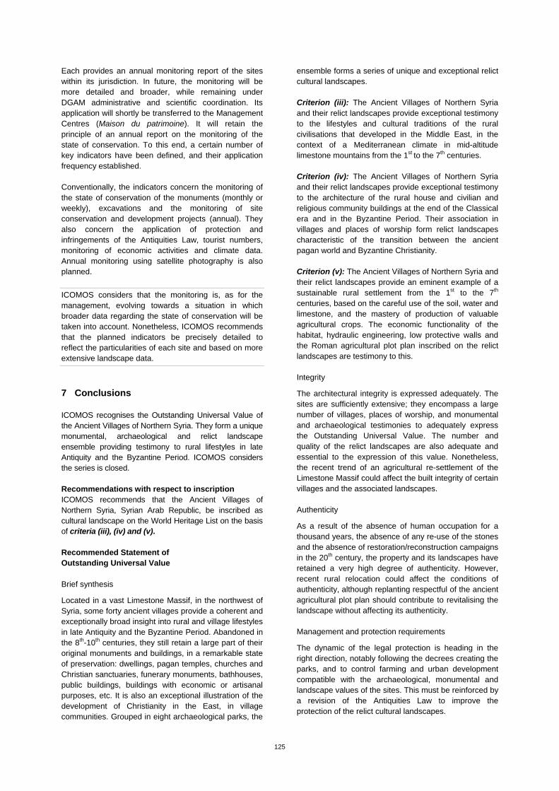
125
Each provides an annual monitoring report of the sites within its jurisdiction. In future, the monitoring will be more detailed and broader, while remaining under DGAM administrative and scientific coordination. Its application will shortly be transferred to the Management Centres (Maison du patrimoine). It will retain the principle of an annual report on the monitoring of the state of conservation. To this end, a certain number of key indicators have been defined, and their application frequency established. Conventionally, the indicators concern the monitoring of the state of conservation of the monuments (monthly or weekly), excavations and the monitoring of site conservation and development projects (annual). They also concern the application of protection and infringements of the Antiquities Law, tourist numbers, monitoring of economic activities and climate data. Annual monitoring using satellite photography is also planned.
ICOMOS considers that the monitoring is, as for the management, evolving towards a situation in which broader data regarding the state of conservation will be taken into account. Nonetheless, ICOMOS recommends that the planned indicators be precisely detailed to reflect the particularities of each site and based on more extensive landscape data.
7 Conclusions ICOMOS recognises the Outstanding Universal Value of the Ancient Villages of Northern Syria. They form a unique monumental, archaeological and relict landscape ensemble providing testimony to rural lifestyles in late Antiquity and the Byzantine Period. ICOMOS considers the series is closed. Recommendations with respect to inscription ICOMOS recommends that the Ancient Villages of Northern Syria, Syrian Arab Republic, be inscribed as cultural landscape on the World Heritage List on the basis of criteria (iii), (iv) and (v). Recommended Statement of Outstanding Universal Value Brief synthesis
Located in a vast Limestone Massif, in the northwest of Syria, some forty ancient villages provide a coherent and exceptionally broad insight into rural and village lifestyles in late Antiquity and the Byzantine Period. Abandoned in the 8th-10th centuries, they still retain a large part of their original monuments and buildings, in a remarkable state of preservation: dwellings, pagan temples, churches and Christian sanctuaries, funerary monuments, bathhouses, public buildings, buildings with economic or artisanal purposes, etc. It is also an exceptional illustration of the development of Christianity in the East, in village communities. Grouped in eight archaeological parks, the
ensemble forms a series of unique and exceptional relict cultural landscapes. Criterion (iii): The Ancient Villages of Northern Syria and their relict landscapes provide exceptional testimony to the lifestyles and cultural traditions of the rural civilisations that developed in the Middle East, in the context of a Mediterranean climate in mid-altitude limestone mountains from the 1st to the 7th centuries. Criterion (iv): The Ancient Villages of Northern Syria and their relict landscapes provide exceptional testimony to the architecture of the rural house and civilian and religious community buildings at the end of the Classical era and in the Byzantine Period. Their association in villages and places of worship form relict landscapes characteristic of the transition between the ancient pagan world and Byzantine Christianity. Criterion (v): The Ancient Villages of Northern Syria and their relict landscapes provide an eminent example of a sustainable rural settlement from the 1st to the 7th centuries, based on the careful use of the soil, water and limestone, and the mastery of production of valuable agricultural crops. The economic functionality of the habitat, hydraulic engineering, low protective walls and the Roman agricultural plot plan inscribed on the relict landscapes are testimony to this. Integrity
The architectural integrity is expressed adequately. The sites are sufficiently extensive; they encompass a large number of villages, places of worship, and monumental and archaeological testimonies to adequately express the Outstanding Universal Value. The number and quality of the relict landscapes are also adequate and essential to the expression of this value. Nonetheless, the recent trend of an agricultural re-settlement of the Limestone Massif could affect the built integrity of certain villages and the associated landscapes. Authenticity
As a result of the absence of human occupation for a thousand years, the absence of any re-use of the stones and the absence of restoration/reconstruction campaigns in the 20th century, the property and its landscapes have retained a very high degree of authenticity. However, recent rural relocation could affect the conditions of authenticity, although replanting respectful of the ancient agricultural plot plan should contribute to revitalising the landscape without affecting its authenticity. Management and protection requirements
The dynamic of the legal protection is heading in the right direction, notably following the decrees creating the parks, and to control farming and urban development compatible with the archaeological, monumental and landscape values of the sites. This must be reinforced by a revision of the Antiquities Law to improve the protection of the relict cultural landscapes.
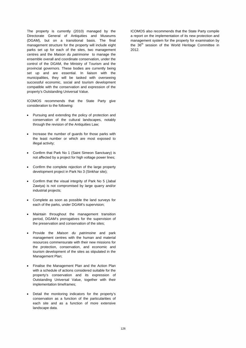
126
The property is currently (2010) managed by the Directorate General of Antiquities and Museums (DGAM), but on a transitional basis. The final management structure for the property will include eight parks set up for each of the sites, two management centres and the Maison du patrimoine to manage the ensemble overall and coordinate conservation, under the control of the DGAM, the Ministry of Tourism and the provincial governors. These bodies are currently being set up and are essential. In liaison with the municipalities, they will be tasked with overseeing successful economic, social and tourism development compatible with the conservation and expression of the property’s Outstanding Universal Value. ICOMOS recommends that the State Party give consideration to the following: Pursuing and extending the policy of protection and
conservation of the cultural landscapes, notably through the revision of the Antiquities Law;
Increase the number of guards for those parks with the least number or which are most exposed to illegal activity;
Confirm that Park No 1 (Saint Simeon Sanctuary) is not affected by a project for high voltage power lines;
Confirm the complete rejection of the large property development project in Park No 3 (Sinkhar site);
Confirm that the visual integrity of Park No 5 (Jabal Zawiya) is not compromised by large quarry and/or industrial projects;
Complete as soon as possible the land surveys for each of the parks, under DGAM’s supervision;
Maintain throughout the management transition
period, DGAM’s prerogatives for the supervision of the preservation and conservation of the sites;
Provide the Maison du patrimoine and park
management centres with the human and material resources commensurate with their new missions for the protection, conservation, and economic and tourism development of the sites as stipulated in the Management Plan;
Finalise the Management Plan and the Action Plan with a schedule of actions considered suitable for the property’s conservation and its expression of Outstanding Universal Value, together with their implementation timeframes;
Detail the monitoring indicators for the property’s
conservation as a function of the particularities of each site and as a function of more extensive landscape data.
ICOMOS also recommends that the State Party compile a report on the implementation of its new protection and management system for the property for examination by the 36th session of the World Heritage Committee in 2012.
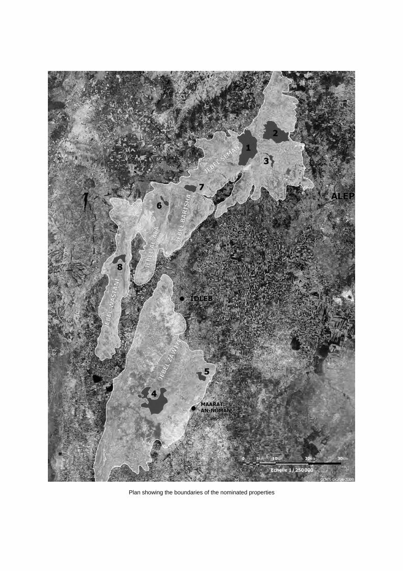
Plan showing the boundaries of the nominated properties
Aerial view of Saint-Simeon site
Village of Sheikh Sliman
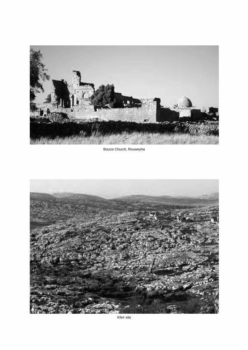
Bizzos Church, Rouweyha
Kfeir site