Embed Size (px)
Citation preview


0468 OU-1 Landfill Area Trenches 0468-SR-03-0
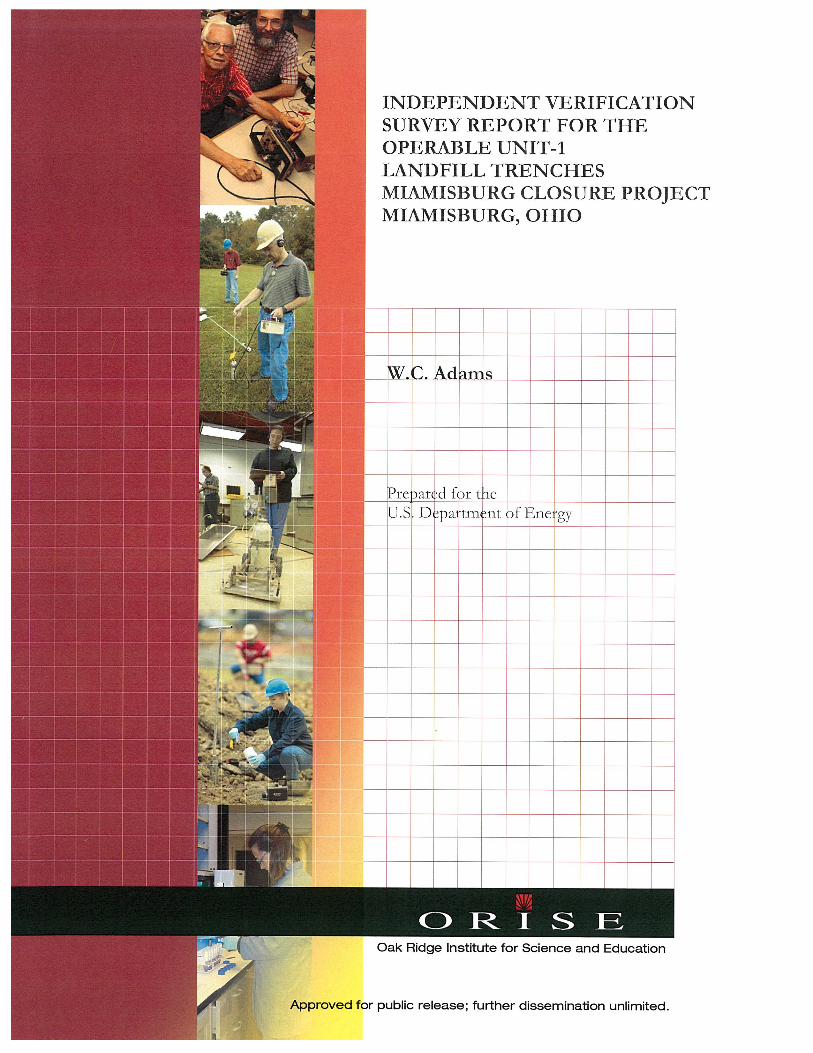
INDEPENDENT VERIFICATION SURVEY REPORT
FOR THE OPERABLE UNIT-1 LANDFILL TRENCHES MIAMISBURG CLOSURE PROJECT
MIAMISBURG, OHIO
Prepared by
W. C. Adams
Oak Ridge Institute for Science and Education
Oak Ridge, Tennessee 37831-0017
Prepared for the U.S. Department of Energy
FINAL REPORT
July 2010 This report is based on work performed by the Oak Ridge Institute for Science and Education Under contract number DE-AC05-06OR23100 with the Department of Energy.

0468 OU-1 Landfill Area Trenches 0468-SR-03-0
ACKNOWLEDGMENTS
The author would like to acknowledge the significant contributions of the following staff members:
PROJECT STAFF
E. Montalvo
LABORATORY STAFF
R. D. Condra J. S. Cox
W. P. Ivey W. F. Smith
CLERICAL STAFF
J. L. Clary R. M. Fink
K. M. Moore A. Ramsey
ILLUSTRATOR
A. Hood

OU-1 Landfill Area Trenches i 0468-SR-03-0
TABLE OF CONTENTS
PAGE
Table of Contents ............................................................................................................................................... i
List of Figures ..................................................................................................................................................... ii
List of Tables ..................................................................................................................................................... iii
Abbreviations and Acronyms .......................................................................................................................... iv
Introduction and Site History .......................................................................................................................... 1
Site Description .................................................................................................................................................. 2
Objective ............................................................................................................................................................. 3
Document Review ............................................................................................................................................. 3
Verification Survey Procedures ........................................................................................................................ 3
Applicable Site Guidelines ................................................................................................................................ 5
Findings and Results .......................................................................................................................................... 6
Comparison of Results With Guidelines ........................................................................................................ 7
Summary .............................................................................................................................................................. 7
References ........................................................................................................................................................... 9
Appendices:
Appendix A: Figures
Appendix B: Data Table
Appendix C: Major Instrumentation
Appendix D: Survey and Analytical Procedures
OU-1 Landfill Area Trenches ii 0468-SR-03-0
LIST OF FIGURES
PAGE
Figure A-1: Map of Miamisburg, Ohio Area ─ Miamisburg Closure Project .................................... A-1
Figure A-2: Miamisburg Closure Project Operable Unit-1 Landfill Area Plot Plan .......................... A-2
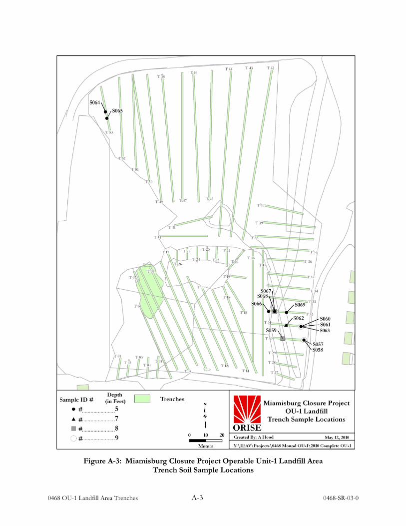
Figure A-3: Miamisburg Closure Project Operable Unit-1 Landfill Area Trench Soil Sample Locations .................................................................................................................................. A-3

OU-1 Landfill Area Trenches iii 0468-SR-03-0
LIST OF TABLES
PAGE
Table 1: Radiological Contaminants Of Concern Cleanup Objectives Operable Unit-1 Landfill Trenches ............................................................................................................................................... 5
Table 2: ORISE Radionuclide Concentration Ranges In Soil Samples Summary Results For Operable Unit-1 Landfill Trenches .................................................................................................. 6
Table B-1: Radionuclide Concentrations In Soil Samples Operable Unit-1 Landfill Trenches .........B-1
OU-1 Landfill Area Trenches iv 0468-SR-03-0
ABBREVIATIONS AND ACRONYMS
ARC Accelerated Remediation Company ARRA American Recovery and Reinvestment Act BKG background
BWXTO Babcock and Wilcox Technical Services of Ohio CERCLA Comprehensive Environmental Response, Compensation,
and Liability Act cm centimeter cm2 square centimeter CO cleanup objectives cpm counts per minute COC contaminants of concern DOE U.S. Department of Energy D&D Decontamination and Decommissioning EIP Environmental Investigation Plan EPA Environmental Protection Agency FIDLER Field Instrument for the Detection of Low Energy Radiation FSS final status survey GPS global positioning system IEAV Independent Environmental Assessment and Verification
ISM Integrated Safety Management ITP Intercomparison Testing Program IVC Independent Verification Contractor IVT Independent Verification Team JHA job hazard analysis kg kilogram MAPEP Mixed Analyte Performance Evaluation Program MCP Miamisburg Closure Project
MDC minimum detectable concentration MERP Mound Environmental Restoration Program MeV million electron volts MRC Monsanto Research Corporation NaI sodium iodide NIST National Institute of Standards and Technology NPL National Priorities List NRIP NIST Radiochemistry Intercomparison Program OEPA Ohio Environmental Protection Agency ORAU Oak Ridge Associated Universities ORISE Oak Ridge Institute for Science and Education OU Operable Units pCi/g picocuries per gram PRS Potential Release Site Pu-238 Plutonium-238 RA Removal Action Ra-226 Radium-226
OU-1 Landfill Area Trenches v 0468-SR-03-0
ABBREVIATIONS AND ACRONYMS (continued)
Th-230/232 Thorium-230/232 TAP total absorption peak VSAP Verification Sampling and Analysis Plan U-233/234 Uranium-233/234 U-235/238 Uranium-235/238
OU-1 Landfill Area Trenches 0468-SR-03-0
INDEPENDENT VERIFICATION SURVEY REPORT FOR THE OPERABLE LAND UNIT-1 LANDFILL TRENCHES
MIAMISBURG CLOSURE PROJECT MIAMISBURG, OHIO
INTRODUCTION AND SITE HISTORY
The Mound Plant was constructed in the 1940s for the production of nuclear weapons components.
In 1948 the original site was operated by the Monsanto Research Corporation (MRC) whose primary
mission was to determine the chemical and metallurgical properties of polonium, (BWXTO 1999).
In 1949, research involving other radionuclides began and over the course of its 50 years of
operation, the facility produced detonators, recovered and purified tritium, and constructed
plutonium heat generators for satellites. Mound was the first permanent facility in support of
atomic weapons research for the U.S. Department of Energy (DOE) and, prior to 1996, it was a
supplier of stable isotopes to the DOE.
The Mound Site was placed on the National Priorities List (NPL) in 1989 because of chemical
contamination in the site groundwater (BWXTO 1999). The DOE, U.S. Environmental Protection
Agency (EPA), the Ohio Environmental Protection Agency (OEPA) and the DOE “core team”,
developed a procedural framework for the remediation of the site under the Comprehensive
Environmental Response, Compensation, and Liability Act (CERCLA). In an effort to improve
efficiency and streamline operations, a decision-making process known as the “The Mound 2000
Approach” was developed by the Mound Environmental Restoration Program (MERP). This
process divided the Mound site into 19 release blocks that contained over 400 Potential Release Sites
(PRSs). Eventually, the PRSs were subdivided into nine operable units (OUs) (MERP 1997).
Approximately 200 of the PRSs were contaminated soil areas and the remaining PRSs were
contaminated buildings (BWXTO 1999).
During the period between 1948 and 1977, an area of about four acres on the southwest portion of
the Mound Plant was used as a landfill for general trash and solid and liquid laboratory wastes
contaminated with radioactive and non-radioactive materials (ARC 2006 and 2007a). This area
would become known as the Operable Unit (OU)-1. Various trenches were opened in OU-1 to
dispose of wastes; however, not all of the trenches were used for waste disposal. Between 1977 and
1978, an overflow pond was constructed in the upper portion of the OU-1 area that partially
0468 OU-1 Landfill Area Trenches 2 0468-SR-03-0
covered the historic landfill. Waste excavated during the construction of the pond was relocated to
other portions of the encapsulated OU-1 Landfill. By 1976, no additional wastes were disposed of
in OU-1 (ARC 2007a).
Accelerated Remediation Company (ARC) is the current decommissioning contractor tasked with an
environmental investigation of the unremediated OU-1 Landfill Area. Their objective was to
determine boundaries and provide evidence that no remaining contaminated wastes remained in
these areas. To determine the boundaries of the OU-1 Landfill Area, ARC excavated trenches in the
northeastern corner, eastern border, and southeastern corner of OU-1. The investigative results of
these activities will provide support for the future use of the OU-1 Area.
These final investigative activities included visually checking the excavations for waste, performing
gamma surface scans, and collecting soil samples to make certain that the radionuclide
contaminants-of-concern (COC) meet the site cleanup objectives (CO) for the OU-1 Landfill Area.
This investigation was being conducted under the 2009 American Recovery and Reinvestment Act
(ARRA) (ARC 2009a).
The U.S. Department of Energy-Miamisburg Closure Project Office (DOE/MCP) is responsible for
oversight of the remedial action and final status survey (FSS) activities at the Miamisburg Closure
Project (MCP). It is the policy of the DOE to perform independent (third party) verification of FSS
activities (DOE 2006). The objectives for independent verifications are to confirm that remedial
actions have been effective in meeting established and site-specific guidelines and that the
documentation accurately and adequately describes the radiological conditions at the site. The Oak
Ridge Institute for Science and Education (ORISE) has been designated by the DOE as the
Independent Verification Contractor (IVC) responsible for this task at the MCP and has been
requested to verify the final radiological status of the cleanup activities associated with the OU-1
Landfill.
SITE DESCRIPTION
The Mound Plant is located on 305 acres within the southern city limits of Miamisburg, Ohio and is
approximately ten miles southwest of Dayton and 45 miles north of Cincinnati. The site is bounded
by Mound Avenue to the north which curves to the south becoming Mound Road and the eastern
boundary of the site (Figure A-1). The southern boundary is formed by Benner Road with the

0468 OU-1 Landfill Area Trenches 3 0468-SR-03-0
Conrail Railroad generally forming the western boundary. To the west of the plant is the Great
Miami River flowing from northeast to southwest and the plant is surrounded by residential,
recreational and agricultural areas (BWXTO 1999). The OU-1 Landfill occupies approximately
4 acres of land in the southwestern portion of the original Mound Plant property (Figure A-2).
OBJECTIVE The objectives of the independent verification survey were designed to provide assurance to DOE
that the contractor has met the cleanup objectives (CO) that were established and that
documentation accurately and adequately describes the current radiological conditions of the
northern, eastern and southeastern borders of the OU-1 Landfill Area.
DOCUMENT REVIEW
The Independent Verification Team (IVT) reviewed the Verification Sampling and Analysis Plan
(VSAP), the Environmental Investigation plan (EIP), and supporting data and documentation for
the release of the OU-1 Landfill Area (ARC 2009a and b). The focus of the review included the
survey methodology, instrumentation detection capabilities and calibration, field observations of the
trench excavations, and applicable investigative procedure implementation required in the the VSAP
and EIP.
VERIFICATION SURVEY PROCEDURES
ORISE personnel visited the MCP Site in Miamisburg, Ohio on April 14 and 15, 2010 to perform
independent verification activities at the OU-1 Landfill Area excavated trenches (Figures A-1, A-2
and A-3). Verification activities were conducted in accordance with the ORISE Independent
Environmental Assessment and Verification (IEAV) Program’s Project-Specific Verification Plan,
and the Survey Procedures and Quality Program Manuals (ORISE 2007a and 2008, and
ORAU 2009). The collective site areas verified consisted of four trenches; of which, three trenches
were along the southeast portion of the Landfill Area (Trenches 30, 31, and 32; Figure A-3) and one
along the northwest portion of the Landfill Area (Trench 53; Figure A- 3). Data and sample media
collected during ORISE verification surveys were returned to the ORISE laboratory for data
interpretation and analyses.
0468 OU-1 Landfill Area Trenches 4 0468-SR-03-0
Due to the depth and potential for cave in of the trenches, FSS by the site decommissioning
contractor and verification surveys by ORISE personnel were conducted only on the excavated soil
piles. The bottom of the trenches and the excavated soil piles were to be inspected for evidence of
any landfill wastes.
The ORISE survey design approach included direct gamma surface scans and measurements and the
collection of soil samples. Locations where gamma surface scans identified elevated radioactivity
levels were marked for further investigation.
REFERENCE SYSTEM ORISE used the reference system and OU-1 Landfill Area trench maps as provided by the
decommissioning contractor for referencing sample locations. ARC personnel used a global
positioning system (GPS) for documenting trench boundaries and a tape measure to document
distances along the trench path for their systematic soil sample locations from the excavated soil
piles.
SURFACE SCANS Surface scans to identify locations of elevated gamma radiation were performed with two different
types of instruments. The Field Instrument for the Detection of Low Energy Radiation (FIDLER)
detector was used for the detection of low-energy gamma radiation, and the 1.25 inch by 1.50 inch
sodium iodide (NaI) scintillation detector was used for the detection of high-energy gamma
radiation. Both the NaI and FIDLER detectors were coupled to ratemeters with audible output.
Gamma surface scans were performed over approximately 75% of accessible excavated soil pile
surface areas and in the immediate vicinity of the four trenches identified by ORISE for
independent verification (Figure A-3). Detectors were held at a nominal height of 5 centimeters
(cm) above the ground surface when performing scans. Locations of elevated gamma radiation
detected by surface scans were marked for further investigation.
SOIL SAMPLING A random sequence generator (Random.org) was used to define twelve random sample locations
from the decommissioning contractor’s soil sample locations of the excavated soil from each of the
0468 OU-1 Landfill Area Trenches 5 0468-SR-03-0
four available trenches. A static gamma count rate measurement was performed at each location
prior to collecting a sample. An additional judgmental soil sample was collected from the east end
of Trench 31 based on a slightly elevated FIDLER gamma reading. Sampling locations are provided
in Figure A-3.
SAMPLE ANALYSIS AND DATA INTERPRETATION Soil samples were maintained in accordance with formal chain-of-custody procedures. Samples and
data were returned to the ORISE/IEAV laboratory in Oak Ridge, Tennessee for analysis and
interpretation. Sample analyses were performed in accordance with the ORISE Laboratory
Procedures Manual (ORISE 2010). Soil samples were analyzed by gamma spectroscopy for the
radionuclide COCs. The spectra were also reviewed for other identifiable photopeaks that would
not be expected at this site and none were identified. Soil sample results were reported in units of
picocuries per gram (pCi/g). Data were compared with the approved release criteria established for
the MCP OU-1 Landfill Area. Additional information concerning major instrumentation, sampling
equipment, and analytical procedures is provided in Appendices C and D.
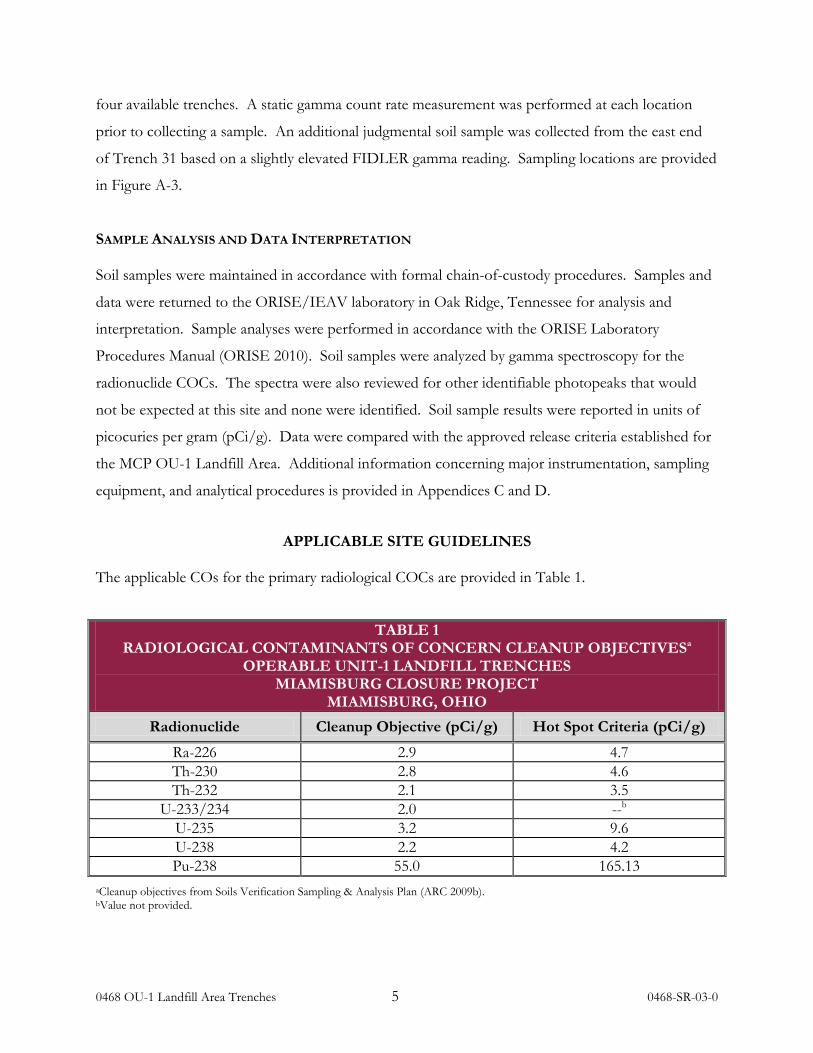
APPLICABLE SITE GUIDELINES The applicable COs for the primary radiological COCs are provided in Table 1.
TABLE 1 RADIOLOGICAL CONTAMINANTS OF CONCERN CLEANUP OBJECTIVESa
OPERABLE UNIT-1 LANDFILL TRENCHES MIAMISBURG CLOSURE PROJECT
MIAMISBURG, OHIO Radionuclide Cleanup Objective (pCi/g) Hot Spot Criteria (pCi/g)
Ra-226 2.9 4.7 Th-230 2.8 4.6 Th-232 2.1 3.5
U-233/234 2.0 --b U-235 3.2 9.6 U-238 2.2 4.2 Pu-238 55.0 165.13
aCleanup objectives from Soils Verification Sampling & Analysis Plan (ARC 2009b). bValue not provided.

0468 OU-1 Landfill Area Trenches 6 0468-SR-03-0
FINDINGS AND RESULTS DOCUMENT REVIEW
ORISE provided technical review and comments on the VSAP for the Mound Operable Unit-1
Landfill Area on April 30, 2007 (ORISE 2007b). ORISE reviewed the EIP for the OU-1 Landfill
Area; however, no additional technical comments were provided (ARC 2009a). ORISE reviewed
the initial data package for Trenches 29 and 30 and determined that an ARC soil sample number had
been inadvertently placed in the wrong area of the trench map. This was brought to the attention of
the ARC personnel and was immediately corrected.1
GAMMA SURFACE SCANS
The gross (including background) area ambient gamma radiation scan results for the NaI detector
were generally between 3,200 and 5,100 counts per minute (cpm). FIDLER scan results were
generally between 400 and 720 cpm. Scans using the FIDLER detector identified one slightly
elevated and isolated location of radioactivity (Figure A-3). This location was marked for sampling.
RADIONUCLIDE CONCENTRATIONS The radionuclide concentration ranges for the primary radiological COCs are provided in Table 2.
The radionuclide concentrations for individual soil sample results, as determined by gamma
spectrometry, for randomly selected soil samples and the judgemental sample are reported in
Table B-1.
TABLE 2 ORISE RADIONUCLIDE CONCENTRATION RANGES IN SOIL SAMPLES
SUMMARY RESULTS FOR OPERABLE UNIT-1 LANDFILL TRENCHES MIAMISBURG CLOSURE PROJECT
MIAMISBURG, OHIO
Trench Radionuclide Concentrations (pCi/g)
Ra-226 Th-230 Th-232 U-235 U-238
All Trenches 0.58 to 0.93 -0.8 to 1.9 0.37 to 0.60 0.02 to 0.06 0.57 to 0.96
All verification soil samples results were below the COs established for the site.
1Electronic mail from C. Gerbig (ARC) to W. Adams (ORISE), RE: Maps and Sample Coordinates; May 10, 2010.
0468 OU-1 Landfill Area Trenches 7 0468-SR-03-0
ORISE also reviewed ARC’s field screening gamma spectroscopy results for the ORISE evaluated
trenches. The qualitative review indicated that with the exception of Th-230 concentration, the
ARC gamma spectroscopy method has the necessary radiological sensitivity to detect the primary
radiological COCs.
VISUAL OBSERVATIONS
Visual observation of the trench bottoms and excavated soil was performed to identify waste.
ORISE did not observe any visible wastes within the soil piles or trenches.
COMPARISON OF RESULTS WITH GUIDELINES
Gamma spectroscopy results indicated that all soil sample radionuclide concentrations were at
background levels; therefore, no need to perform alpha spectroscopy to determine isotopic
abundances for plutonium or uranium. This approach was accepted by the DOE Project Manager.
Radionuclide concentrations in all soil samples collected are listed in Table B-1.
SUMMARY On April 14 and 15, 2010, the ORISE IVT conducted independent verification survey activities in a
four acre area of the OU-1 Landfill at the Miamisburg Closure Project in Miamisburg, Ohio. The
IVT performed gamma scans and collected soil samples to quantify the remaining radiological
concentrations of the contaminants of concern in the OU-1 Landfill Area. Low energy gamma
radiation scans performed by the IVT identified and sampled a small isolated soil location with
activity greater than background. Analysis of the sample indicated that the COCs were well below
the concentration guidelines. A qualitative comparison of the ORISE results and the contractor
results indicated that the contractors’ field screening method has the detection sensitivity necessary
to evaluate the radiological COC concentrations, with the exception of Th-230 concentrations. The
minimum detectable activity reported by the contractor for field screening gamma spectroscopy was
higher than the clean-up goal of 2.8 pCi/g. However, all individual sample and mean concentrations
were below the guidelines. Visual observations did not identify any wastes in the open excavated
pits. Therefore, ORISE is of the opinion that the process for evaluating the pits sufficiently allows
the contractor to meet site clean-up objectives.

0468 OU-1 Landfill Area Trenches 8 0468-SR-03-0

0468 OU-1 Landfill Area Trenches 9 0468-SR-03-0
REFERENCES Accelerated Remediation Company (ARC). The Response Action Plan for the Operable Unit One (OU-1) Landfill Area at the Miamisburg Closure Project. Miamisburg, Ohio; July 2006.
Accelerated Remediation Company. Soils Verification Sampling and Analysis Plan Mound Operable Unit 1 Landfill Area. Miamisburg, Ohio; January 2007a.
Accelerated Remediation Company. Environmental Investigation Plan for the Operable Unit 1 (OU-1) Landfill Area. Project Document ID: MP-507.F; Revision 1. Miamisburg, Ohio; November 9, 2009a.
Accelerated Remediation Company. Soils Verification Sampling & Analysis Plan Mound Operable Unit 1 Landfill Area. Project Document ID: MP-507.E; Revision 0. Miamisburg, Ohio; July 20, 2009b.
BWXT of Ohio, Inc. (BWXTO). Work Plan for Environmental Restoration of the DOE Mound Site, The Mound 2000 Approach. Revision 0. Miamisburg, Ohio; February 1999.
Mound Environmental Restoration Program (MERP). Mound 2000 Residual Risk Evaluation Methodology. Revision 0. Miamisburg, Ohio; January 6, 1997.
Oak Ridge Associated Universities (ORAU). Quality Program for the Independent Environmental Assessment and Verification Program. Oak Ridge, Tennessee; June 30, 2009.
Oak Ridge Institute for Science and Education (ORISE). Final Project-Specific Plan for the Independent Verification of Areas OU-1 and PRS 441 at the Department of Energy Miamisburg Closure Project, Miamisburg, Ohio. DOE Contract No. DE-AC05-06OR23100. Oak Ridge, Tennessee; April 11, 2007a.
Oak Ridge Institute for Science and Education. Document Review─Comments on the Verification Sampling & Analysis Plan and Supporting Procedures for Area OU-1 at the Department of Energy Miamisburg Closure Project, Miamisburg, Ohio. DOE Contract No. DE-AC05-06OR23100. Oak Ridge, Tennessee; April 30, 2007b.
Oak Ridge Institute for Science and Education. Survey Procedures Manual for the Independent Environmental Assessment and Verification Program. Oak Ridge, Tennessee; May 1, 2008.
Oak Ridge Institute for Science and Education. Laboratory Procedures Manual for the Independent Environmental Assessment and Verification Program. Oak Ridge, Tennessee; March 1, 2010.
U.S. Department of Energy(DOE). Environment, Safety and Health Bulletin: A Guide to Good Practices for the Control and Release of Property. DOE/EH-0697. Washington, DC; July 2006.

0468 OU-1 Landfill Area Trenches 0468-SR-03-0
APPENDIX A
FIGURES

0468 OU-1 Landfill Area Trenches A-1 0468-SR-03-0
Figure A-1: Map of Miamisburg, Ohio Area ─ Miamisburg Closure Project

0468 OU-1 Landfill Area Trenches A-2 0468-SR-03-0
Figure A-2: Miamisburg Closure Project Operable Unit-1 Landfill Area Plot Plan
0468 OU-1 Landfill Area Trenches A-3 0468-SR-03-0
Figure A-3: Miamisburg Closure Project Operable Unit-1 Landfill Area
Trench Soil Sample Locations

0468 OU-1 Landfill Area Trenches 0468-SR-03-0
APPENDIX B
DATA TABLE

0468 OU-1 Landfill Area Trenches B-1 0468-SR-03-0
TABLE B- 1 RADIONUCLIDE CONCENTRATIONS IN SOIL SAMPLES
OPERABLE UNIT-1 LANDFILL TRENCHES MIAMISBURG CLOSURE PROJECT
MIAMISBURG, OHIO
Sample ID/Locationa
Sample Coordinatesb
Gamma Measurement
(cpm)
Radionuclide Concentrations (pCi/g)
Northing Easting Ra-226 Th-230 Th-232 U-235 U-238 Trench 30
S057 597053 1464432 4,200 0.80 ± 0.06c -0.5 ± 1.2 0.44 ± 0.05 0.04 ± 0.02 0.72 ± 0.08 S058 597053 1464432 4,100 0.78 ± 0.05 0.60 ± 0.88 0.47 ± 0.05 0.02 ± 0.02 0.72 ± 0.09 S059 597056 1464389 3,900 0.81 ± 0.05 0.75 ± 0.21 0.44 ± 0.05 0.06 ± 0.01 0.82 ± 0.07
Average 4,100 0.80 0.28 0.45 0.04 0.75 Trench 31
S060 597080 1464426 4,500 0.80 ± 0.05 1.36 ± 0.63 0.50 ± 0.05 0.05 ± 0.01 0.79 ± 0.08 S061 597080 1464426 4,600 0.78 ± 0.05 0.57 ± 0.68 0.45 ± 0.05 0.04 ± 0.01 0.74 ± 0.08 S062 597083 1464396 3,900 0.80 ± 0.07 1.11 ± 0.59 0.49 ± 0.06 0.04 ± 0.02 0.78 ± 0.09
Average 4,300 0.79 1.01 0.48 0.04 0.77 S063d 597080 1464425 4,200 0.78 ± 0.04 0.7 ± 1.1 0.60 ± 0.07 0.05 ± 0.01 0.77 ± 0.07
Trench 53 S064 597510 1464033 4,400 0.88 ± 0.06 1.1 ± 2.6 0.49 ± 0.05 0.05 ± 0.01 0.69 ± 0.08 S065 597497 1464036 3,800 0.58 ± 0.03 -0.8 ± 1.1 0.37 ± 0.05 0.04 ± 0.02 0.57 ± 0.07
Average 4,100 0.73 0.15 0.43 0.05 0.63 Trench 32
S066 597110 1464361 4,100 0.84 ± 0.07 0.89 ± 0.60 0.47 ± 0.06 0.05 ± 0.02 0.85 ± 0.10 S067 597110 1464373 4,400 0.84 ± 0.05 0.67 ± 0.47 0.46 ± 0.05 0.06 ± 0.01 0.88 ± 0.08 S068 597109 1464373 4,200 0.93 ± 0.06 1.9 ± 1.2 0.48 ± 0.05 0.05 ± 0.01 0.96 ± 0.09 S069 597108 1464397 4,300 0.85 ± 0.05 1.23 ± 0.10 0.43 ± 0.05 0.05 ± 0.01 0.75 ± 0.07
Average 4,300 0.87 1.17 0.46 0.05 0.86 aRefer to Figure A-3. bSample coordinates provided by DeNuke. cUncertainties are at the 95% confidence level based on total propagated uncertainties. dJudgmental soil sample collected based on FIDLER gamma scan reading
0468 OU-1 Landfill Area Trenches 0468-SR-03-0
APPENDIX C
MAJOR INSTRUMENTATION
0468 OU-1 Landfill Area Trenches C-1 0468-SR-03-0
APPENDIX C
MAJOR INSTRUMENTATION
The display of a specific product is not to be construed as an endorsement of the product or its manufacturer by the author or her employer.
SCANNING INSTRUMENT/DETECTOR COMBINATIONS
Fluke NaI Scintillation Detector Model 489-55, Crystal: 3.2 cm x 3.8 cm (Fluke, Cleveland, OH) coupled to: Ludlum Ratemeter-Scaler Model 2221 (Ludlum Measurements, Inc., Sweetwater, TX) Bicron Field Instrument Detector for Low Energy Radiation (FIDLER) Model G5 (Bicron Corporation, Newburg, OH) coupled to: Ludlum Ratemeter-Scaler Model 2221 (Ludlum Measurements, Inc., Sweetwater, TX) LABORATORY ANALYTICAL INSTRUMENTATION
High Purity Extended Range Intrinsic Detector CANBERRA/Tennelec Model No: ERVDS30-25195 (Canberra, Meriden, CT) Used in conjunction with: Lead Shield Model G-11 (Nuclear Lead, Oak Ridge, TN) and Multichannel Analyzer (Canberra, Meriden, CT)
High Purity Extended Range Intrinsic Detector Model No. GMX-45200-5 (AMETEK/ORTEC, Oak Ridge, TN) used in conjunction with: Lead Shield Model SPG-16-K8 (Nuclear Data) Multichannel Analyzer (Canberra, Meriden, CT) Canberra Apex Gamma Software (Dell Workstation)

0468 OU-1 Landfill Area Trenches C-2 0468-SR-03-0
LABORATORY ANALYTICAL INSTRUMENTATION (CONTINUED)
High-Purity Germanium Detector Model GMX-30-P4, 30% Eff. (AMETEK/ORTEC, Oak Ridge, TN) Used in conjunction with: Lead Shield Model G-16 (Gamma Products, Palos Hills, IL) and Multichannel Analyzer (Canberra, Meriden, CT)

0468 OU-1 Landfill Area Trenches 0468-SR-03-0
APPENDIX D
SURVEY AND ANALYTICAL PROCEDURES

0468 OU-1 Landfill Area Trenches D-1 0468-SR-03-0
APPENDIX D
SURVEY AND ANALYTICAL PROCEDURES
PROJECT HEALTH AND SAFETY
The survey and sampling procedures were evaluated to ensure that any hazards inherent to the
procedures themselves were addressed in current job hazard analyses (JHAs). All survey and
laboratory activities were conducted in accordance with ORISE health and safety and radiation
protection procedures.
Pre-survey activities included an overview of potential health and safety issues. Representatives with
the Accelerated Remediation Company (ARC) provided site-specific safety awareness training for
each individual ORISE survey effort. In-process and verification surveys were performed according
to the ORISE generic health and safety plan, site-specific Integrated Safety Management (ISM) pre-
job hazard checklist, and safety procedures discussed during the on-site training.
CALIBRATION AND QUALITY ASSURANCE
Calibration of all field and laboratory instrumentation was based on standards/sources, traceable to
the National Institute of Standards and Technology (NIST).
Analytical and field survey activities were conducted in accordance with procedures from the
following ORAU and ORISE documents:
• Survey Procedures Manual (May 2008)
• Laboratory Procedures Manual (March 2010)
• Quality Program Manual (June 2009)
The procedures contained in these manuals were developed to meet the requirements of 10 CFR
830 Subpart A, Quality Assurance Requirements, Department of Energy Order 414.1C Quality Assurance,
and the U.S. Nuclear Regulatory Commission Quality Assurance Manual for the Office of Nuclear Material
Safety and Safeguards and contain measures to assess processes during their performance.

0468 OU-1 Landfill Area Trenches D-2 0468-SR-03-0
Quality control procedures include:
• Daily instrument background and check-source measurements to confirm that equipment
operation is within acceptable statistical fluctuations.
• Participation in Mixed-Analyte Performance Evaluation Program (MAPEP), NIST
Radiochemistry Intercomparison Testing Program (NRIP), and Intercomparison Testing
Program (ITP) Laboratory Quality Assurance Programs.
• Training and certification of all individuals performing procedures.
• Periodic internal and external audits.
SURVEY PROCEDURES Surface Scans
Scans for elevated gamma radiation were performed by passing the detector slowly over the surface.
The distance between the detector and surface was maintained at a nominal distance of about 1 to 5
cm. Identification of elevated radiation levels was based on increases in the audible signal from the
instrument.
The scan minimum detectable concentrations (MDCs) for the NaI scintillation detector for the
contaminants of concern in surface soil were obtained directly from NUREG-1507 when available
or estimated using the calculation approach described in NUREG-15072
Soil Sampling
. A typical NaI detector
(1.5 inch × 1.25 inch) MDC is 4.5 pCi/g for Ra-226, 3000 pCi/g for Th-230, 2.8 pCi/g for Th-232,
115 pCi/g for natural uranium (56 pCi/g for U-238, 56 pCi/g for U-234 and 3 pCi/g for U-235).
ORISE used the FIDLER for qualitative measurements. An audible increase in the activity rate was
investigated by ORISE. It is standard procedure for the ORISE staff to pause and investigate any
locations where gamma radiation is distinguishable from background levels.
Approximately 0.5 to 1 kilogram (kg) of soil was collected at each sample location. Collected
samples were placed in plastic bags, sealed, and labeled in accordance with ORISE survey
procedures.
2NUREG-1507. Minimum Detectable Concentrations With Typical Radiation Survey Instruments for Various Contaminants and Field Conditions. U.S. Nuclear Regulatory Commission. Washington, DC; June 1998.
0468 OU-1 Landfill Area Trenches D-3 0468-SR-03-0
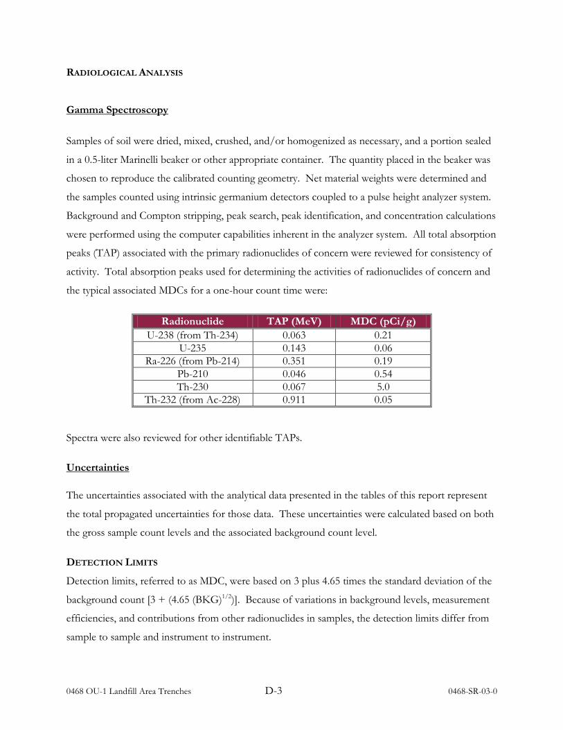
RADIOLOGICAL ANALYSIS
Gamma Spectroscopy
Samples of soil were dried, mixed, crushed, and/or homogenized as necessary, and a portion sealed
in a 0.5-liter Marinelli beaker or other appropriate container. The quantity placed in the beaker was
chosen to reproduce the calibrated counting geometry. Net material weights were determined and
the samples counted using intrinsic germanium detectors coupled to a pulse height analyzer system.
Background and Compton stripping, peak search, peak identification, and concentration calculations
were performed using the computer capabilities inherent in the analyzer system. All total absorption
peaks (TAP) associated with the primary radionuclides of concern were reviewed for consistency of
activity. Total absorption peaks used for determining the activities of radionuclides of concern and
the typical associated MDCs for a one-hour count time were:
Radionuclide TAP (MeV) MDC (pCi/g) U-238 (from Th-234) 0.063 0.21
U-235 0.143 0.06 Ra-226 (from Pb-214) 0.351 0.19
Pb-210 0.046 0.54 Th-230 0.067 5.0
Th-232 (from Ac-228) 0.911 0.05
Spectra were also reviewed for other identifiable TAPs.
Uncertainties The uncertainties associated with the analytical data presented in the tables of this report represent
the total propagated uncertainties for those data. These uncertainties were calculated based on both
the gross sample count levels and the associated background count level.
DETECTION LIMITS
Detection limits, referred to as MDC, were based on 3 plus 4.65 times the standard deviation of the
background count [3 + (4.65 (BKG)1/2)]. Because of variations in background levels, measurement
efficiencies, and contributions from other radionuclides in samples, the detection limits differ from
sample to sample and instrument to instrument.