Embed Size (px)
Citation preview
Natural Resource Inventory (NRI) Franklin Township, Warren County, New Jersey
Prepared by Princeton Hydro, LLC 16 June 2007
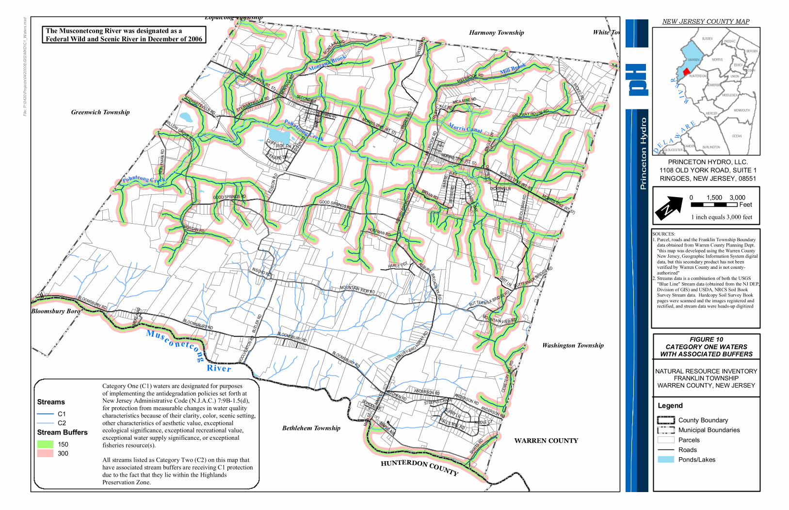
11: C1 STREAMS AND BUFFER REQUIREMENTS In the beginning of 2004, new Stormwater Quality rules were adopted, as mandated by the United States Environmental Protection Agency. NJDEP took additional steps to identify and protect high quality water resources. These special water resource protection areas are established along all waters designated Category One (C1), and perennial or intermittent streams that drain into or upstream of C1 waters. These areas are established for the protection of water quality, aesthetic value, exceptional ecological significance, exceptional recreational significance, exceptional water supply significance, and exceptional fisheries. The most notable regulation is the implementation of a 300 foot buffer zone on each bank of a C1 stream. Other rules deal with designated areas for future development, the creation of a stream corridor protection plan, and cleaner stormwater discharge into the special water protection area, or the C1 stream itself. For the official rules regarding the special water resources protection areas, please reference the New Jersey Register (N.J.A.C. 7:8-5.5(h)), (http://www.nj.gov/dep/rules/adoptions/2004_0202_watershed.pdf). In addition, all streams located within the Highlands Preservation Area, are afforded 300 foot buffers per the Highlands Water Protection and Planning Act. Route 57/ Morris Turnpike bisects the Township and delineates the boundary between the Highlands Planning and Preservation Areas. Therefore, all stream segments north of Route 57 within the Township are protected by 300 foot buffers because they lie within the Highlands Preservation Area. Portions of the Musconetcong River also serve as a Highlands Preservation/Planning Area border in the southern section of the Township. Thus, the sections of the Musconetcong River that delineate this line, the western and eastern stretches within the Township, are protected by 300 foot buffers. The tributaries that flow through the central portion of the Township that are not classified as C1 waters and that lie within the Highlands Planning Area are not protected by 300 foot buffers. For more information on the Highlands Act, please refer to Section 16 and http://www.state.nj.us/dep/highlands and http://www.highlands.state.nj.us. Approximately 19.45 stream miles are protected by the C1/300 stream buffer requirement within Franklin Township. (Figure 10). The C1 streams include: Halfway House Brook, Montana Brook, Mill Brook, one tributary to the Musconetcong River, and Pohatcong Creek and all its tributaries. All stream segments that are included in the Highlands Preservation Area are afforded 300 foot buffers and include: Halfway House Brook, Montana Brook, Mill Brook and the eastern and western stretches of the Musconetcong River.
HUNTERDON COUNTY
WARREN COUNTY
M orris CanalPohatcong Creek
Pohatcong Creek
Mill BrookMontana Brook
Musc o netcong River
Bloomsbury Boro
Bethlehem Township
Greenwich Township
Washington Township
Harmony Township
MAPLE AVE
BICKEL RD
BUTLE
R RD
KITCHEN RDANDERSON RD
SHIRTS RD
GOOD SPRINGS RD
MORRIS TPKE (RT. 57)
WHITE
S RD
HARLE Y CT
BRYAN RD
EDISO
N RD
DIRT LN
HER L
E MA N
R D
HOFFMAN RD
BEIDL
EMAN
RD
MICA MINE RD
INSCHO RD
BUTTER M ILK BRIDGE RD
MONTAN
A RD
STEWARTSVILLE RD
WOOLVE
RTON R
D
SURRY LN
CLIFF S IDE DR
MORGAN RD
L ENA PE TRL
HALL S MILL RD
YOLM
AN RD
OBERLY CT
SCHOOL ST
CEME
TERY
HILL
RD
HALFWAY HOU SE RD
STEEPLE CHASE
WARNE WAY
VAN S
YC
KLE RD
RIDDLE CT
LIMEK
ILN RD
SECOND ST
SINGL
EY LN
WILLOW GROVE RD
MART
AVE
DICKENS LN
MAIN
ST
MILLBR
OOK R
D
BLOOMSBURY RD
MOUNTAIN VIEW RD
THIRD ST
ASBURY-BRO ADWAY
RD
WARN
E WAY
ASBU
RY-BR
OADW
AY RD
BLOOMSBURY RD
BLOOMSBURY RD
ASBURY-BROADW AY RD
BLOOMSBURY RD
MORRIS TPKE (RT. 57)
MILLBROOK RD
MORRIS TPKE (RT. 57)
ANDERSON RDANDERSON RD
GOOD SPRINGS RD
MORRIS TPKE (RT. 57)
ST EWARTSVILLE RD
MORRIS TPKE (RT. 57)
EDISO
N RD
BUTTE R MILK BRIDGE RD
MAIN S
T
BRYA
N RD
M ONTANA R D
MO UN TAIN VI EW RD
White TownshipLopatcong Township
File:
P:\04
20\Pr
ojects
\0420
006\G
IS\MX
D\C1
_Wate
rs.mx
d NEW JERSEY COUNTY MAP
FIGURE 10CATEGORY ONE WATERS
WITH ASSOCIATED BUFFERS
DE L A W
A R E
RIV
ER
OCEAN
MORRIS
SUSSEX
BURLINGTON
WARREN
MONMOUTH
HUNTERDON
BERGEN
MIDDLESEX
MERCER
PASSAIC
ESSEX
UNION
SOMERSET
CAMDENGLOUCESTER
HUDSON
SALEM
U 0 3,0001,500Feet
1 inch equals 3,000 feet
SOURCES:1. Parcel, roads and the Franklin Township Boundary data obtained from Warren County Planning Dept. "this map was developed using the Warren County New Jersey, Geographic Information System digital data, but this secondary product has not been verified by Warren County and is not county- authorized"2. Streams data is a combination of both the USGS "Blue Line" Stream data (obtained from the NJ DEP, Division of GIS) and USDA, NRCS Soil Book Survey Stream data. Hardcopy Soil Survey Book pages were scanned and the images registered and rectified, and stream data were heads-up digitized
NATURAL RESOURCE INVENTORYFRANKLIN TOWNSHIP
WARREN COUNTY, NEW JERSEY
LegendCounty BoundaryMunicipal BoundariesParcelsRoadsPonds/Lakes
PRINCETON HYDRO, LLC.1108 OLD YORK ROAD, SUITE 1RINGOES, NEW JERSEY, 08551
StreamsC1C2
Stream Buffers150300
Category One (C1) waters are designated for purposesof implementing the antidegradation policies set forth atNew Jersey Administrative Code (N.J.A.C.) 7:9B-1.5(d),for protection from measurable changes in water qualitycharacteristics because of their clarity, color, scenic setting,other characteristics of aesthetic value, exceptionalecological significance, exceptional recreational value,exceptional water supply significance, or exceptionalfisheries resource(s).All streams listed as Category Two (C2) on this map thathave associated stream buffers are receiving C1 protectiondue to the fact that they lie within the Highlands Preservation Zone.
The Musconetcong River was designated as aFederal Wild and Scenic River in December of 2006


![(STRIKE?) [09] IO Subsystem - University of Cambridge · Terminal streams not terminals, windows not frame buffer,event ... Rather than polling,processors provide an interrupt mechanism](https://img.pdfslide.us/doc/110x75/5b90be5b09d3f2857e8c9c3c/strike-09-io-subsystem-university-of-terminal-streams-not-terminals.jpg)