Embed Size (px)
Citation preview
J. W. Pomeroy, T. Brown, G. Kite, D. M. Gray, R J. Granger, A Pietroniro
Land Use National Hydrology Research Centre
1 1 Innovation Blvd. Saskatoon Saskatchewan S7N 3HS
PBS-SLURP MODEL
Prepared for SaskWater and the Upper Assiniboine River Basin Study
NHRI Contribution Series No. CS-98003
Executive Summary
In September, 1997 SaskWater contracted NHRI to provide an enhancement of
NHRI's SLURP Hydrological Model that would be appropriate for modelling the
hydrological impacts of land use change in Upper Assiniboine River Basin. NHRI
scientists identified snow redistribution, evaporation and infiltration into frozen soils
as the hydrological processes for which SLURP was in most need of enhancement for
application to the prairie environment. Dr. Geoff Kite of NHRl developed and
provided SaskWater with SLURP-1 1 code and manual in October, 1997; SLURP-1 1
contains NHRI's Granger Evapotranspiration Model.
This final report details the work in coupling NHRT's Prairie Blowing Snow Model
(PBSM), a frozen soil infiltration routine and other modifications to SLURP. The
coding and simulations were performed by Mr. Tom Brown, P.Eng., of Rowan
Systems and formerly of the Division of Hydrology, Univ. of Saskatchewan. The
completed model is substantially changed from SLURP-1 1 and is called PBS-SLURP.
PBS-SLURP is demonstrated using data from the Bad Lake International
Hydrological Decade basin. It shows snow accumulation, snow melt, infiltration and
runoff characteristics are strongly intluenced by land cover (fallow, stubble, coulees)
and that substantial errors in sprins snowmelt runoff calcuIations would accrue from
assuming an even snowcover and infiltration characteristics. The authors recommend
however, that further enhancements to PBS-SLLRP may be necessary for general
application in the Prairies. These enhancements are specific to snowmelt energetics
and soil moisture accounting. The next phase of this project will involve SaskWater
applying PBS-SLURP in the Upper Assiniboine Basin with the advice and input of
hrHRI scientists.
INTRODUCTION.
Hydrological modelling in the Canadian Prairie environment is notoriously
difficult because of poorly-defined drainage basins, low dopes, intermittent
streamflow, land use changes and often dramatic seasonal and interannual variations
in precipitation and temperature. Prairie hydrology is also distinctive because of the
cold and dry continental climate. Roughly one-third of annual precipitation arrives as
snowfall yet roughly 80-90% of annual runoff occurs during the snowmelt season.
Hydrological processes that are important in the Prairie environment, yet not normally
included in hydrological models, are associated with seasonally-frozen soils, wind,
redistribution of snowfall, river ice, snowrnelt, evaporation fiom cold soils, and
aspects of soiI moisture retention in agricultural soils. Research over the last 30 years
at the National Hydrology Research Centre and the Division of Hydrology, University
of Saskatchewan has attempted to address deficiencies in the understanding of prairie
hydrology processes and to develop physically-based algorithms describing these
processes.
This report details the incorporation of certain key prairie hydrological process
alsorithms into a tvell-known hydrological model, S L W . SLL'RP is a semi-
distributed hydrological model chat has been in continuous development at
Environment Canada since its initial conception in the 1970s (Kite, 1978). SLURP
has been extensively tested and calibrated in the mountain environment of British
Columbia, and used in varied environments such as the Mackenzie hve r (Ktte, 1994).
By treating the river basin as a series of sub-catchments, or ASA', each with a
distinctive arrangement of land covers, SLURP effectively distributes hydrological
fluxes and is therefore sensitive to land use and the spatial arrangement of land cover
within a basin. Water balances are generated in each ASA and then routed through
the basin. The routing and certain hydrological coefficients are optimised for an
environment using a calibration from known discharge data for the basin and
subcatchments (if available). For application to the Prairies, specifically for the
Upper Assiniboine Basin, it was considered appropriate to modify SLURP to take
' Aggregated Simulation Area.

advantage of the advances in understanding of prairie hydrological processes that
have occurred since its inception, thus improving its physical basis. With an
improved physical basis for key prairie hydrological processes, it is felt that SLURP
can more confidently predict changes to prairie hydrology due to land use and climate
change.
The changes to SLURP detailed here are extensive and deal with phenomena
that influence snowmelt runoff generation:
1. winter evaporation and soil drainage,
2. infiltration to fiozen soils and
3. wind redistribution of snow.
Snowmelt produces the annual peak flow in most prairie basins, and can produce
extreme flood events, such as the Red River Flood of 1997. Snowmelt runoff is
extremely variable fiom year to year because of changes in spring snow water
equivalent (SWE) over the basin and variation in the amount of meltwater that
infiltrates soil and recharges soil water supplies versus that which runs off to channels
and contributes to streamflow. In order to calculate snowmelt fluxes and runoff, it is
necessary to know correct snowfall, evaporation from snowcover, overwinter soil
moisture drainage, redistribution of snow by blowing snow, sublimation of blowing
snow, and intiltration of meltwater into soils. The following sections discuss the
couplins of SLLW and prairie hydrology process algorithms that permit a more
process-based calculation of snowmelt runoff using what is effectively a new model
PBS-SLURP. The changes permit PBS-SLURP to assess the impact of land use on
snow accumulation, infiltration and snowmelt runoff, and demonstrate the strong role
land cover has in controlling runoff generation on the Prairies.
HYDROLOGICAL PROCESSES FOR THE PRAIRIES
Pomeroy and Gray (1995) detailed the influence of wind redistribution on
prairie SWE, showing that from 1.6 to 39.4 Mg of snow per metre width of field can
be relocated from fields to drift areas (shelterbelts, coulees, sloughs) in the Prairie
Provinces. Depending on fetch and local climate, an amount of snow from 1.0 to 2.6
times that transported off the field is sublimated (evaporation direct from snow to
vapour) and is therefore not available for melt in the spring. The calculation of
blowing snow transport and sublimation involves a complex simulation of snowfall
correction, snowpack mass balance, mid-winter snowmelt, wind erosion of snow,
snow particle transport and heat and mass transfer to the blowing snow particles. The
calculation procedure has been coded into a computer model, called the Prairie
Blowing Snow Model, PBSM (Pomeroy, 1989; Pomeroy et al., 1993; Pomeroy and
Li, 1997), which has been developed at Environment Canada since that time. For
application with SLURP, a technique was developed to use PBSM to relocate snow
from land cover to land cover within an ASA, based on the roughness of land cover
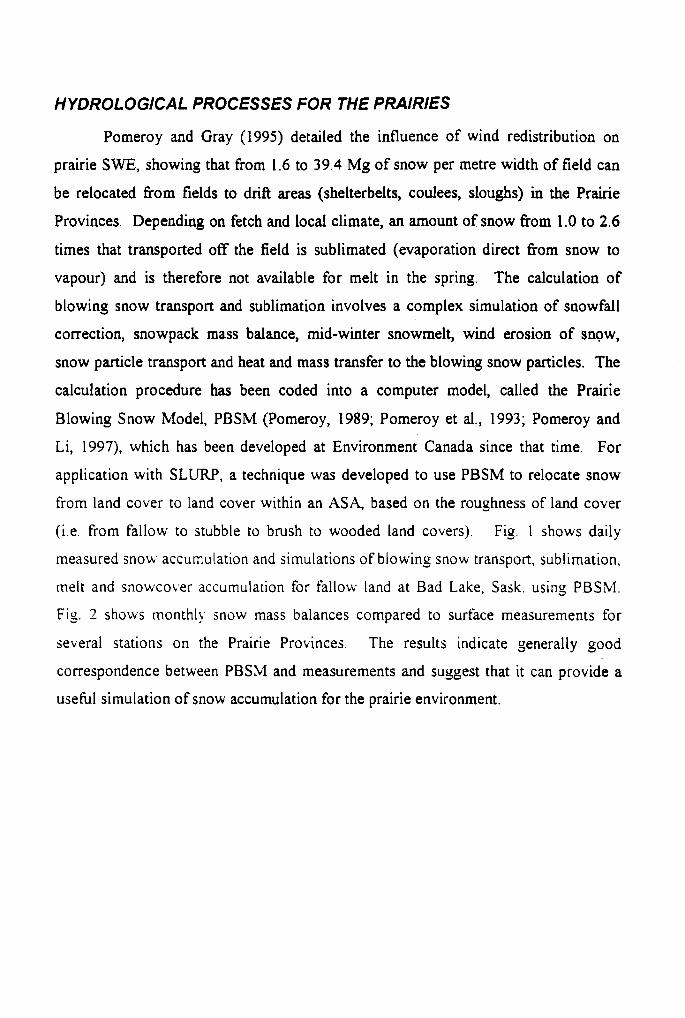
(i.e. from fallow to stubble to brush to wooded land covers). Fig. 1 shows daily
measured snow accumulation and simulations of blowing snow transport, sublimation,
melt and snowcover accumulation for fallow land at Bad Lake, Sask. using PBSM.
Fig. 2 shows monthly snow mass balances compared to surface measurements for
several stations on the Prairie Provinces. The results indicate generally good
correspondence between PBSM and measurements and suggest that it can provide a
usehl simulation of snow accumulation for the prairie environment.
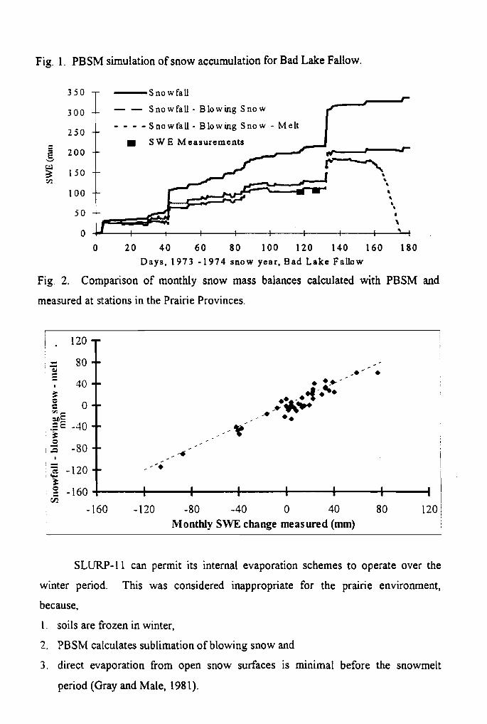
Fig. 1. PBSM simulation of snow accumulation for Bad Lake Fallow.
S n o w Fall
300 , SnowFall - Blowing S n o w
- - - - Snowfall - Blowing S n o w - Melt I S W E Measurements
--
--
-- a a 8 8
\
0 20 40 6 0 80 100 120 140 160 180 Days , 1973 -1974 snow year. Bad Lake Fallow
Fig. 2. Comparison of monthly snow mass balances calculated with PBSM and
measured at stations in the Prairie Provinces.
klonthly SWE change measured (mm)
SLURP-1 1 can permit its internal evaporation schemes to operate over the
winter period. This was considered inappropriate for the prairie environment,
because,
1. soils are frozen in winter,
2. PBSFvI calculates sublimation of blowing snow and
3. direct evaporation from open snow surfaces is minimal before the snowmelt
period (Gray and Male, 198 1).
Evaporation schemes in SLURP were therefore disabled over the snow-covered
period, until the time of active snowmelt.
Infiltration to frozen soils can vary from zero to the maximum water available
from snowcovers on the Prairies, depending on soil characteristics, mid-winter melts
and the degree of pore saturation in the upper soil layers (Granger et al., 1984). Gray
et al. (1986) classified the infiltration characteristics of frozen prairie soils as
restricted (no infiltration), Limited (variable infiltration with pore saturation) and
unlimited (complete infiltration). Simple algorithms were developed to describe and
predict the infiltration characteristics of prairie soils; the algorithms describe
extensive field results quite well. When these algorithms were used to modify the US
National Weather Service Runoff and Forecasting Simulation, predicted snowmelt
runoff from agricultural basins in south-central Saskatchewan increased fiom
negligible to the large snowmelt freshet normally observed (Gray et al., 1986). This
result demonstrates the degree of simulation improvement that can be expected by
incorporating frozen soil infiltration routines into a hydrological model.
In implementing the infiltration routines in SLURP, soil drainage and runoff
generation from upper soil layers were restricted during the winter period when soils
are frozen. During snowmelt, soils are classified into one of three infiltration classes,
restricted, limited or unlimited, based on soil texture, fall moisture content and mid-
\\Inter melt Meltwater generation in excess to that which can infiltrate is directed as
ru no t'f.
The next section in this report details the coupling of PBSM-SLURP and
infiltration to frozen soil routines to create PBS-SLURP. Further sections describe
PBSM, SLURP and Infiltration to frozen soil sub-models. Appendix A lists the input
requirements of PBS-SLURP, Appendix B shows program changes in creating PBS-
SLLW from SLURP-I I , Appendix C shows model runs of PBS-SLURP for
Creighton Tributary of Bad Lake Basin and Appendix D lists the PBS-SLURP code.
PBS-SLURP MODEL FEATURES
SLURP-1 1
The SLURP model is a complex model which has been under continuous
development since its inception in 1978 (Kite, 1978). As such, any refinements have
to be integrated into the existing program structure even if this is not the optimum
method. The alternative is an extensive and very time consuming rewrite and the risk
of altering the accepted operation of the model. SLURP is described in
documentation provided with Version 11 (Kite, Oct. 1997) and in several papers by
Kite. The following is a description of those aspects of SLURP that are important for
integration with blowing snow and frozen soil routines.
The SLURP program operates sequentially through the land delineations in the
following order:
1. Sequentially through every ASA, (i.e. sub-basin),
2. Sequentially through every land cover type within an ASA.
3 Sequentially through the land cover for the entire run time period.
The ASX'S have to be ordered by drainage sequence. Upstream ASA's which drain
into a do~vnstream ASA must appear first in the .AS.\ list. There is no such
requirement for land covers in the original SLLRP model.
Each element of the (AS.A*land cover) matrix is simulated by four nonlinear
reservoirs representing canopy interception, snowpack, fast runoff (may be considered
as a combined surface storage and top soil layer storase) and slow runofl (may be
considered as groundwater). The storage areas affected by the addition of the routines
to handle snow transport and infiltration into frozen soil are the snowpack and fast
storaye. The snowpack operates as one would expect, starting at zero in the fall and
gradually increasing in depth with snowfall and snow transport or decreasing with
sublimation and melt.
Fast storage is handled as a linear tank filled by precipitation and melt. All
water is free to empty through evaporation and drainage. Fast storage does not,
however, accurately represent physical soil moisture regimes. One of the parameters
for fast storage is its maximum capacity. This would imply that if a soil layer depth is
associated with fast storage then soil moisture would be represented. The potential
evaporation is determined by the selected evaporation method (Morton, Granger or

Spittlehouse./Black) and as long as there is sufficient water in fast storage, the
evaporation demand can be satisfied. However, as soon as fast storage content is
drawn down to zero, it is the lack of moisture which is the controlling influence in the
model, rather than the evaporation method selected. The drainage mechanism is
similar and again can empty fast storage.
Snowfall Corrections
Snowfall undermeasurement due to wind effects, wetting losses and unrecorded trace
events have been subject to extensive investigation (Pomeroy and Goodison, 1997).
For Canadian measurements Nipher-shielded cylinders are often used to collect
snowfall with measurements of accumulated snowfall made every six hours. he Nipher shield reduces undermeasurement due to wind compared with an unshielded
gauge but corrections are still required. A correction procedure published by
Goodison was incorporated into P B S - S L W to allow the use of uncorrected AES
precipitation data.
Blowing Snow Modelling
Coupling of PBSlll and S L W is made possible by the following modelling features,
developed based on 15 years of study of the blowing snow phenomenon in the prairies
(Pomeroy and Li, 1997) and experiences in distributed modelliny of blowing snow in
the Arctic (Pomeroy et al., 1997):
1. There is no snow transport between ASA's.
2. Daily snowfall is added to the snowcover once per day at midnight.
3 . Snow transport from land covers with lower roughness is added to the snowpack
of land covers with greater roughness once per day at midnight.
4. Transport and sublimation of blowing snow for a land cover are calculated every
hour using the hourly wind speed, air temperature and dewpoint. Snow transport
is summed over the day and passed on to the subsequent land covers of lower
roughness height.
5. No transported snow enters the lowest roughness land cover (normally fallow).
6. All transported snow not distributed onto low roughness land covers is added to
the snowpack of the roughest land cover.
7. When the vegetation height is full, no fbrther snow is deposited but transport
continues to the next roughest land cover.
8. Snowfall and incoming snow transport are added to snowcover at midnight and
then daily snow transport output and sublimation loss are calculated using a one-
hour time increment.
In SLURP, a land cover in a particular ASA is processed through the entire run time
period before starting on the next land cover. This feature makes it difficult to couple
PBSM and SLURP because the snow transport between land covers occurs
concurrently. The problem is handled by requiring the land covers to be ordered
sequentially by increasing roughness (crop or vegetation height). That is, the land
covers are ranked by increasing roughness such that the first land cover on the List fills
with snow to capacity quite early in the season, followed by the second etc. The last
land covers are the ones which fill later in the season and the very last will never fill
at all and is considered to be an infinite sink for wind transported snow (e.g. coulees,
river channels, large wooded areas).
It is assumed that there is no net snow transport between ASA. This
assumption is quite reasonable for ASA with land covers near the perimeter of short
grass or cultivated fields, and fetch length for this land cover of 1 km or more. The
assumption is based on the concept of steady state flow, which develops over low
rou~hness land covers early in the season and takes from 300- 1000 m to develop. As
most prairie catchments have stream channels, sloughs or coulees in the centre rather
than on the perimeter and many catchments have extensive grass or cultivated plains
around the basin boundaries, this assumption is considered good.
There is little or no snow transport out of a land cover until the vegetation
cover is filled to capacity i.e. the snow accumulation is greater than or equal to the
crop height. When this happens, snow transport out of the land cover is saved daily.
When the entire time period is simulated using that land cover, the program
progesses to the next land cover in the ASA, calculating its daily transport and
sublimation using the snow transported from the previously processed land cover in
the ASA. The transport out of a land cover is deposited over the remaining land
covers using the deposition parameters specified by the user in the *.PBS file. To
determine the deposition parameters, the user of the model examines a map of the
ASA area showing crops and farmland practices in the fall, topography, vegetation,
together with the prevailing winter winds to determine the distribution of drift From
fallow to the other land classes in the A S 4 e.g. stubble, grass, gullies, river channels,
forest etc. It is recommended that model users consult the NHRI Science Report No.
7, Snow Accumulation, Redistribution and Management by J.W. Pomeroy and D.M.
Gray, for principles and techniques for classifying landscape with respect to snow
redistribution by blowing snow and to determine prevailing snow transport directions
for various locations in the Prairie Provinces.
Winter Evaporation Modelling
Gray and Male (1 98 1) provided information that demonstrates overwinter evaporation
fiom snow covers in cold periods is minimal. PBS-SLURP has been adjusted to
reflect this. The following adjustments are made for selected condition.
1. No Snow Cover-
Use Slurp Evaporation Methods as given (Morton/Granger/Spittlehouse-
Black).
2. Snow Cover-
Air Temperature greater than 0°C
Use selected evaporation model.
Air Temperature less than or equal to 0°C
Use only PBSM sublimation
Plant canopies
Use S L W evaporation at any temperature
Frozen Soil Infiltration Modelling in PBS-SLURP
In SLURP-1 1, the ratio of current stored water content to its maximum water
content has no direct relationship to soil water status and cannot be used as an
indicator of soil moisture, however this ratio is important for spring runoff generation.
There is no mechanism in the model to reduce or terminate soil drainage when the
ground is frozen. A reasonable adjustment for the prairie environment is therefore to
stop all drainase between fall and the spring snow melt. In the spring, melt thaws the
frozen soil. This change has been implemented in PBS-SLURP.
Based upon 15 years of study of the snow hydrology of the Prairie region and
results reported in the former USSR, the Division of Hydrology (Granger et al. 1984;
Gray et al., 1986), postulated that the infiltration potential of frozen soils may be
grouped in three broad categories, namely, restricted, limited and unlimited.
Restricted - Infiltration is impeded by an impermeable layer, such as an ice
lens on the soil surface or within the soil close to the surface. For all practical
purposes, the amount of meltwater infiltration can be assumed to be negligible and
that the melt goes directly to runoff and a little to evaporation.
Limited - Infiltration is governed primarily by the snow-cover water equivalent
and the frozen water content of the top 30 cm. of soil.
Unlimited - A soil with a high percentage of large, air-filled macropores at
time of melt. Examples of soils having these properties are dry, heavily cracked
clays and coarse, dry sands.
In SLURP there is not sufficient information to determine these classifications .
automatically and as a result the operator is required to specify these properties for
each land class every fall and input this information to the model. The one case the
model does handle is when there is an early melt and the subsequent refreezing
causins an ice lens to form. This will change both Limited and Unlimited to
Restricted. Implementation of the infiltration to frozen soils routines is described
belotv.
Definitions
1 . Index = M / S WE where M=5(1-0,)s WE 0 584.
2. Potential = M / 6
3 , MELT-THRESHOLD=lOmm. Minimum daily meltwater at which the melt
routine is enabled. Lower meltwater levels are not counted as one of the six major
melt events.
1. Major melt is a day when the meltwater is Qreater than the MELT-THRESHOLD
5. 6 major daily melts are allowed before the infiltration category is changed to
Restricted.
The Frozen Soil Infiltration routine
1 . The Frozen Infiltration routine will be enabled to start any time after November 1.
2. It will be triggered into operation by the first major melt. At this time, Index and
Potential are calculated from the soil moisture (8,) and the SWE of the snowpack.
Index and Potential will only be recalculated if another major melt occurs with a
greater SWE.
3. The Frozen Infiltration routine will be disabled when the SWE of the snowpack is
less than 5mm and a major melt has occurred.
4. Disabling the frozen infiltration routine at a SWE of Smm is reasonable for
shallow snowpacks which melt rapidly but is not satisfactory for deeper
accumulations. However, since the meltwater Erom deeper snowcovers tends to
runoff to adjacent areas and the ground does not Ereeze as deeply under deeper
snowpack, it is reasonable to assume that the Erozen infiltration routine should be
disabled for all land covers at the same time.
The three frozen soil categories are described below
LIMITED
1. Only six major over-winter snowmelt events are possible before the infiltration
potential is set to Restricted.
3. Meltwater amounts less than the MELT-THRESHOLD are allowed to infiltrate
into the soil using unfrozen soil infiltration routines. Once iLLELT - THRESHOLD
has been exceeded (normal spring snowmelt) only the amount of meltwater equal
to ;LELT*lndex Lvill infiltrate and the remainder will be handled as runoff. That
is, after a major melt the normal fast storage infiltration limits for unfrozen soil
are suppressed and the frozen soil routines take over.
3 . If the temperature the day after a major melt event is colder than -lO°C, the
category is changed from Limited to Restricted.
W I k l I T E D
1 . All meltwater is allowed to infiltrate after a major snow melt event. Prior to this
infiltration is handled by the normal Slurp infiltration routine.
2. If the temperature the day after a major melt event is less than -IO°C, the category
remains unchanged and all melt water still infiltrates into the soil.
3. Unlimited is ended when the model returns to its normal infiltration routine at the
end of melt in spring.
RESTRICTED
1. No meltwater is allowed to infiltrate.
2. When the SWE of the snowpack is less than 5mm, the category is no longer
applicable as the Frozen Infiltration routine is no longer operational in the
program. The Slurp program will thereafter use its normal unfiozen soil
infiltration routines.
Snowmelt
SLURP implements two melt routines. The frrst is a simple degree-day approach
using the positive difference between the daily average temperature and
parameter(l0). The melt rate RI uses a parabolic correction fiom January and July
minimum and maximum values. The second is a simplified energy budget method
proposed by Kustas et al. (1994), which also includes the above simple degree day
term.
PBS-SLURP TESTING AT BAD LAKE, SASKATCHEWAN
PBS-SLLRP was run for the Creighton Tributary of Bad Lake basin for the winters
1973-74 and 1974-75. Creighton Tributary was chosen because of its comprehensive
hydrology and land cover dataset, collected during the International Hydrological
Decade during a high snowfall and normal snowfall year. A simple division of the
basin into fallow, stubble and drift land cover classifications was used.
''Drift" land cover was selected for steep shrub-covered slopes, coulee bottoms,
farm yards.
"Fallow" and "stubble" land cover were selected based on land use surveys of
summer-fallowed and grain stubble or pasture lands respectively.-
The percentage areas of the three land covers is 40% fallow, 50% stubble, 10% drift.
The redistribution of snow by the model between the different land covers is
illustrated in Fig. 1 & 2. SWE accumulation for the three land covers for the two
years, together with the corrected snowfall and measured SWE from field surveys is
given. The resulting ratios of fallow, stubble, drift accumulation are in the ranges
predicted from the snow surveys reported by Pomeroy and Li (1997). This suggests
from a regional mass balance that the ratio of blowing snow transport to sublimation
is reasonable. However modelled snow accumulation is substantially more than that
measured. This is not considered to be due to underestimation of blowing snow
erosion as this would make the overestimation of drift accumulation worse, but to an
underestimate of mid-winter melt. PBS-SLURP does not allow its simple degree-day
melt algorithm to operate when the daily mean temperature is below the value set in
parameter(l0). When parameter(l0) is set to 0 C, there is very little mid-winter melt
as the average daily temperature on the prairies between Xovembtr and March is
normally below 0°C despite afternoon temperatures which can be over 0°C. Shook
(1995) has demonstrated that significant melt can occur on the Prairies when daily
mean temperatures are below freezing, and model that use the daily mean temperature
for estimating melt can be up to several weeks late in predicting the onset of melt.
The output from the oriyinal PBSM produces more melt during February and
March simulating prairie conditions more closely, and matches the observed field
measurements better (see Pomeroy and Li, 1997). One reason for this is that degree-
day melt in PBSM was implemented using the maximum daily temperature, a more
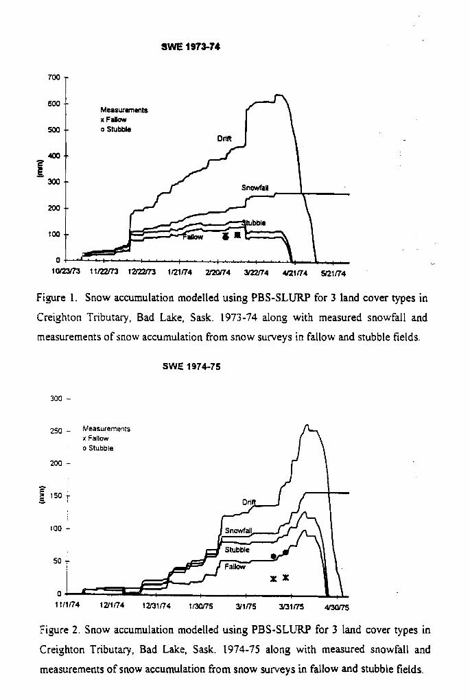
SWE 1973-74
Figure I. Snow accumulation modelled using PBS-SLURP for 3 land cover types in
Creiyhton Tributary, Bad Lake, Sask. 1973-74 along with measured snowfall and
measurements of snow accumulation from snow surveys in fallow and stubble fields.
SWE 1974-75
250 - Measurements x Fallow
I o Stubble
200 -
I
I
I I
Figure 2. Snow accumulation modelled using PBS-SLURP for 3 land cover types in
Creighton Tributary, Bad Lake, Sask. 1974-75 along with measured snowfall and
measurements of snow accumulation from snow surveys in fallow and stubble fields.
appropriate parameter. It is not possible to appropriately calibrate PBS-SLURP in its
present form to overcome this difficulty, without causing more of the precipitation
being handled as rain instead of snow. Parameter(l0) which sets the daily mean
temperature at which melt begins, also sets the dividing temperature between rainfall
and snowfall. Lowering this parameter to correct for meltwater production in mid-
winter would also cause the model to predict rainfall at below freezing temperatures.
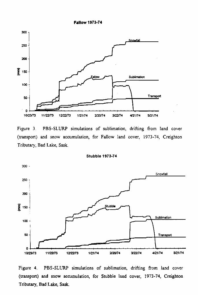
The transport and sublimation losses from the different land covers together
with surface SWE and snowfall are given in Fig. 3 through 6. The sequences show
that all land covers act as snow sinks early in the winter season, and accumulation
tracks well with snowfall. As roughness elements fill, land covers become blowing
snow sources and contribute snow to rougher land covers. In the heavy snowfall
season of 1973-74 all land covers track reasonably well with snowfall until early
December 1973, after that drift exceeds snowfall and fallow and stubble are
substantially less than snowfall. In the moderate snowfall season of 1974-75 all land
covers track well until late December 1974, after which fallow has substantially less
accumulation than snowfall or accumulation at other sites. Drift exceeds snowfall
starting in early February 1975, whilst stubble tracks snowfall fairly well with
snowfall until late March.
Snowmelt runoff for each land cover and basin streamflow runoff for PBS-
S L L W are shown in Fig, 7 & 8. The melt sequence in all years is fallow, stubble,
drift, with drift becoming snow-free up to 3 weeks later than the other land covers. It
is seen that the agricultural field snowmelt occurs for only a few days at the start of
melt and that melt from the drift areas form a larger component of runoff than would
be expected from the relatively small area of the basin covered with snow drifts. In
the heavy snow year (1974), peak melt fluxes from the three land covers occur
sequentially, prolonging and attenuating the amplitude of the basin runoff peak. In
the moderate snow year (1975), fallow and stubble melt at similar times, resulting in a
sharp runoff peak that is much greater than the peak for each land cover. These may
be compared with the measured streamflow from snowmelt on the Creighton
Tributary collected by the Division of Hydrology. There is good correspondence for
spring of 1974. The peak is too high for spring 1975; this may be due to the model
not melting sufficient snowcover during the winter months of February and March or
to a problem in the timing of the melt peaks. 'The peak is also delayed by 2 days but
Again this can be explained by the melt routines shortcomings.
Fallow 1973-74
Sublimation
Transport
Figre 3. PBS-SLURP simulations of sublimation, drifting from land cover
(transport) and snow accumulation, for Fallow land cover, 1973-74, Creighton
Tributary, Bad Lake, Sask.
Stubble 1973-74
Figure 4. PBS-SLURP simulations of sublimation, drifting from land cover
(transport) and snow accumulation, for Stubble land cover, 1973-74, Creighton
Tributary, Bad Lake, Sask.
-
Fallow 1974-75
Figure 5. PBS-SLURP simulations of sublimation, drifting fiom land cover
(transport) and snow accumulation, for Fallow land cover, 1974-75, Creighton
Tributary, Bad Lake, Sask.
Stubble 1974-75
rao -
Figure 6. PBS-SLURP simulations of sublimation, drifting from land cover
(transport) and snow accumulation, for Stubble land cover, 1974-75, Creighton
Tributary, Bad Lake, Sask.
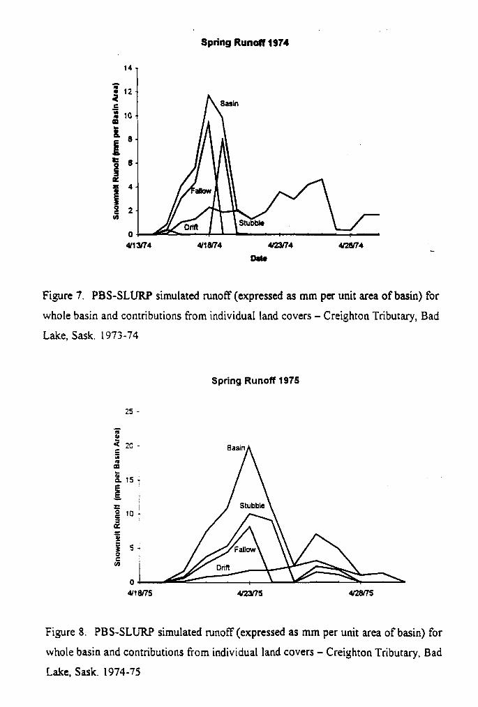
Spring Runoff 1974
Figure 7. PBS-SLURP simulated runoff (expressed as mm per unit area of basin) for
whole basin and contributions from individuaI land covers - Creighton Tributary, Bad
Lake, Sask. 1973-74
Spring Runoff 1975
Figure 8. PBS-SLURP simulated runoff (expressed as mm per unit area of basin) for
whole basin and contributions from individual land covers - Creiyhton Tributary, Bad
Lake, Sask. 1974-75
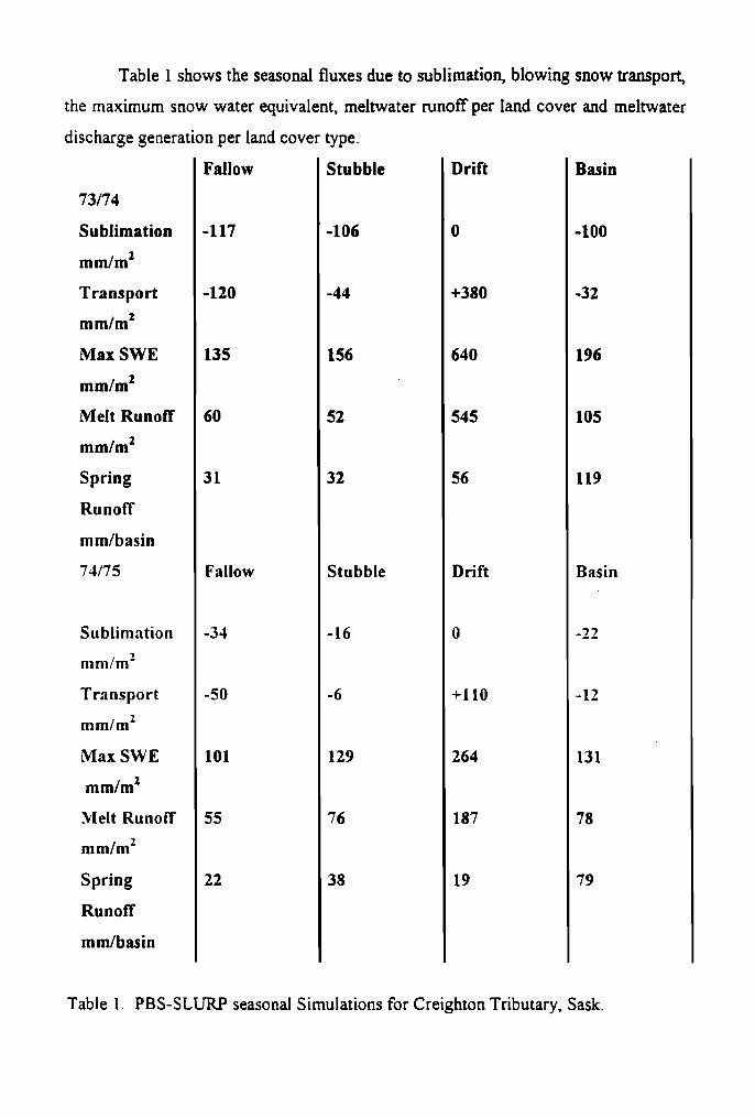
Table 1 shows the seasond fluxes due to sublimation, blowing snow transport,
the maximum snow water equivalent, meltwater runoff per land cover and meltwater
discharge generat
73/74
Sublimation
mm/m2
Transport
mm/m2
Max SWE
mm/m2
Melt Runoff
mm/m2
Spring
Runoff
mm/basin
74/75
Sublimation
mrn/rn2
Transport
mm/m2
M a x SWE
mm/m2
Melt Runoff
mm/m2
Spring
Runoff
mmlbasin
:ion per land cover
Fallow
-1 17
-120
135
60
3 1
Fallow
-34
-50
101
55
22
type-
Stubble
-1 06
-44
156
52
32
Stubble
-16
- 6
129
76
38
Drift
0
+380
640
545
56
Drift
0
+I10
264
187
19
Basin
-1 00
-32
196
105
119
Basin
-3 2
-12
131
78
79
Table 1. PBS-SLURP seasonal Simulations for Creighton Tributary, Sask.

Recommendations
PBS-SLURP has provided a good initial model for incorporation of distinctive and
important Canadian prairie hydrological processes in calculation of streamflow
runoff. To take full advantage of improvements in snow accumulation and infiltration
routines, model requires further improvements in the snowmelt energetics routine. To
make calculation of spring soil moisture and hence snowmelt infiltration more
automated and less subjective, developing a more .physically-based soil moisture
routine in SLURP should be considered.
REFERENCES
Gray, D.M. and D.H. Male 198 1. Handbook of Snow: Principles, Processes,
Management and Use. Pergamon Press, Toronto. 776 p.
Gray, D.M., R J. Granger and P.G. Landine 1986. Modelling snowmelt infiltration
and runoff in a Prairie environment. Ln, Cold Regions Hycbology Symposium.
American Water Resources Association.
Granger, R.J., D.M. Gray and G.E. Dyck 1984. Snowmelt infiltration to frozen
Prairie soils. Canadian Jmrnal of Earth Sciences, 2 1 (6), 669-677.
Kite, G.W. 1978. Development of a hydrological model for a Canadian watershed.
Canadian Journal of Civil Engmeering, 5(1), 126- 134.
Kite, G. W. 1994. Hydrological modelling using remotely sensed data and geographic
information systems. Trends in Hydrology, 1, 19 1-207.
Kite, G.LV 1997. ,Lfcvlrutal for the SLURP Hydrological Mo~iel, k'. I I . National
Hydrology Research institute. Environment Canada, Saskatoon. 159 p.
Kustas, W P.. .A. Ranyo and R. Roberts 1994. A simple energy budget algorithm for
the snowmelt runoff model. Water Resoirrces Research, 30(5), 1 5 15- 1527.
Pomeroy, J. W. and D.M. Gray 1995. Snowcover Accumzrlation, Relocation and
ibffltlngement. MRI Science Report No. 7. National Hydrology Research Institute,
Environment Canada, Saskatoon. 134 p.
Pomeroy, J. W. 1989. A process-based model of snow drifting. Annals of Glaciology,
13, 23 7-240.
Pomeroy, J.W., D.M. Gray and P.G. Landine 1993. The Prairie Blowing Snow
Model: characteristics, validation, operation. Journal of Hyd-ology, 144, 165- 192.
Pomeroy, J.W. and B.E. Goodison 1997. Winter and Snow. In, (eds W. Bailey, T.
Oke and W. Rouse) The Surface Climates of Canada. McGilYQueen's University
Press, Montreal. 68- 100.
Pomeroy, J.W. and L. Li, 1997. Development of the Prairie Blowing Snow Model for
application in climatological and hydrological models. Proceedings of the 65'
Annual Western Snow Conference, 1 86- 197,
Pomeroy, J. W., P. Marsh and D.M. Gray, 1997. Application of a distributed blowing
snow model to the Arctic. Hy&ologzcal Processes, 1 1, 145 1 - 1464.
Shook, K.R. 1995. Simulation of the ablation of prairie smcovers. PhD Thesis,
Dept. of Agricultural and Bioresource Engineering, University of Saskatchewan,
Saskatoon.

![THE MIAMI HERALD MiamiHerald.com/Homes F …wolverines.belenjesuit.org/All County Pages/20082009...|hf1hs030106c]~ |hf1hs030106c]~ final 3hs cyan |hf1hs030106mn~ |hf1hs030106mn~ final](https://img.pdfslide.us/doc/110x75/5b17ebde7f8b9a19258b4e5a/the-miami-herald-f-wolverinesbelenjesuitorgall-county-pages20082009hf1hs030106c.jpg)