Embed Size (px)
Citation preview
Smart People, People Smart
T. +61 2 9956 6962 E. [email protected] W. ethosurban.com
173 Sussex St Sydney NSW 2000
ABN. 13 615 087 931
COMPLIANCE SUMMARY – BINGARA GORGE
The following tables present a detailed summary of the proposal’s compliance with Sydney Regional Plan No 20 – Hawkesbury-Nepean River (SREP 20), the
Wollondilly Local Environmental Plan 2011 and the Wollondilly Development Control Plan 2016. Compliance with other relevant strategic and statutory plans
and policies is discussed in the body of the report.
1.0 Sydney Regional Plan No.20 – Hawkesbury-Nepean River (No.2 – 1997)
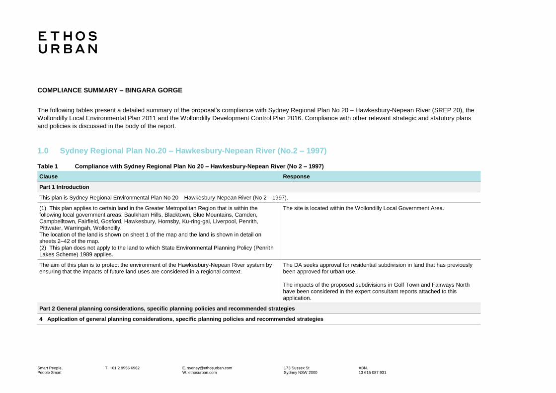
Table 1 Compliance with Sydney Regional Plan No 20 – Hawkesbury-Nepean River (No 2 – 1997)
Clause Response
Part 1 Introduction
This plan is Sydney Regional Environmental Plan No 20—Hawkesbury-Nepean River (No 2—1997).
(1) This plan applies to certain land in the Greater Metropolitan Region that is within the following local government areas: Baulkham Hills, Blacktown, Blue Mountains, Camden, Campbelltown, Fairfield, Gosford, Hawkesbury, Hornsby, Ku-ring-gai, Liverpool, Penrith,
Pittwater, Warringah, Wollondilly. The location of the land is shown on sheet 1 of the map and the land is shown in detail on sheets 2–42 of the map.
(2) This plan does not apply to the land to which State Environmental Planning Policy (Penrith
Lakes Scheme) 1989 applies.
The site is located within the Wollondilly Local Government Area.
The aim of this plan is to protect the environment of the Hawkesbury-Nepean River system by ensuring that the impacts of future land uses are considered in a regional context.
The DA seeks approval for residential subdivision in land that has previously been approved for urban use.
The impacts of the proposed subdivisions in Golf Town and Fairways North have been considered in the expert consultant reports attached to this
application.
Part 2 General planning considerations, specific planning policies and recommended strategies
4 Application of general planning considerations, specific planning policies and recommended strategies

Bingara Gorge | Planning Compliance Tables | 26 October 2018
Ethos Urban | 16681 2
Clause Response
(1) The general planning considerations set out in clause 5, and the specific planning policies
and related recommended strategies set out in clause 6 which are applicable to the proposed development, must be taken into consideration: (a) by a consent authority determining an application for consent to the carrying out of
development on land to which this plan applies, and (b) by a person, company, public authority or a company State owned corporation proposing to carry out development which does not require development consent.
An assessment in relation to each of the relevant clauses is provided in the
following sections.
(2) Those considerations, policies and strategies should be taken into consideration in the preparation of each environmental planning instrument and development control plan that
applies to land to which this plan applies.
Noted.
5 General planning considerations
The general planning considerations relevant for this Part are:
(a) the aim of this plan, and Noted.
(b) the strategies listed in the Action Plan of the Hawkesbury-Nepean Environmental Planning Strategy, and
Noted.
(c) whether there are any feasible alternatives to the development or other proposal concerned, and
The alternative to the proposal – do nothing - is not a reasonable or feasible response. The land in question is zoned residential and concept approval for residential subdivision has been granted by the LEC. Subdivision of the land to
allow for residential development will contribute to the overall development of Bingara Gorge as originally envisioned.
(d) the relationship between the different impacts of the development or other proposal and the environment, and how those impacts will be addressed and monitored.
All relevant environmental impacts have been addressed within the SEE and accompanying expert reports that form part of this application.
6 Specific planning policies and recommended strategies
Policy: Total catchment management is to be integrated with environmental planning for the catchment.
6 (1) Total catchment management
(a) Refer the application or other proposal for comment to the councils of each adjacent or
downstream local government area which is likely to suffer a significant adverse environmental effect from the proposal.
There is not likely to be any significant downstream impacts caused by the
proposal, as demonstrated by the Stormwater and Water Quality Management Strategy Report (Appendix K).
(b) Consider the impact of the development concerned on the catchment. The development is primarily set back from existing waterways, maintaining environmental protection and rehabilitation zones to minimise the impact on
the catchment.
(c) Consider the cumulative environmental impact of development proposals on the catchment. The cumulative impact of the proposal has been considered in the LEC concept approval.
6 (2) Environmentally sensitive areas: Policy: The environmental quality of environmentally sensitive areas must be protected and enhanced through careful control of future land use changes and through
management and (where necessary) remediation of existing uses.
Bingara Gorge | Planning Compliance Tables | 26 October 2018
Ethos Urban | 16681 3
Clause Response
(a) Rehabilitate parts of the riverine corridor from which sand, gravel or soil are extracted so
that attached aquatic plant beds are replaced and water quality and faunal habitats improved.
Development associated with this application is setback from the riverine
corridor. EP&R lands are to be conserved to contribute to the rehabilitation of the riverine corridor.
(b) Minimise adverse impacts on water quality, aquatic habitats, riverine vegetation and bank stability.
As above, development is set back from the riverine corridor and banks so as to minimise impact on the functioning of the watercourse system.
(c) Minimise direct and indirect adverse impacts on land reserved or dedicated under the
National Parks and Wildlife Act 1974 or the Forestry Act 1916 and conservation area sub-
catchments in order to protect water quality and biodiversity.
N/A
(d) Protect wetlands (including upland wetlands) from future development and from the impacts of land use within their catchments.
N/A
(e) Consider the need to include buffer zones (such as adequate fire radiation zones) for proposals on land adjacent to land reserved or dedicated under the National Parks and Wildlife
Act 1974 or the Forestry Act 1916.
Appropriate APZs and buffer zones have been included. Refer to BPA at Appendix D and BMP at Appendix E for further detail.
(f) Consider the views of the Director-General of National Parks and Wildlife about proposals for land adjacent to land reserved or dedicated under the National Parks and Wildlife Act 1974.
N/A
(g) Consideration should be given to the impact of the development concerned on the water table and the formation of acid sulphate soils.
Refer to Stormwater Report at Appendix K and the Contamination Investigation at Appendix R.
(h) New development in conservation area sub-catchments should be located in areas that are already cleared.
No development is proposed in conservation areas (with the exception of approved fire trails).
6 (3) Water quality
Policy: Future development must not prejudice the achievement of the goals of use of the river for primary contact recreation (being recreational activities involving direct water contact, such as swimming) and aquatic ecosystem protection in the river system. If the quality of the receiving waters does not currently allow these uses, the current water quality must be maintained, or improved, so as not to jeopardise the achievement of the goals in the future. When water quality goals are set by the Government these are to be
the goals to be achieved under this policy.
(a) Quantify, and assess the likely impact of, any predicted increase in pollutant loads on receiving waters.
Refer to Stormwater Report at Appendix K.
(b) Consider the need to ensure that water quality goals for primary contact recreation and aquatic ecosystem protection are achieved and monitored.
As above.
(c) Approve development involving primary contact recreation or the withdrawal of water from the river for human contact (not involving water treatment), such as showers, only in locations
where water quality is suitable (regardless of water temperature).
N/A
(d) Do not carry out development involving on-site disposal of sewage effluent if it will adversely affect the water quality of the river or groundwater. Have due regard to the nature and size of the site.
Refer to Stormwater Report at Appendix K.
(e) Develop in accordance with the land capability of the site and do not cause land
degradation.
The subject site has been deemed capable of accommodating the proposed
development as per the original staged approval and the subsequent LEC concept approval for residential subdivision totalling 1800 lots.
Bingara Gorge | Planning Compliance Tables | 26 October 2018
Ethos Urban | 16681 4
Clause Response
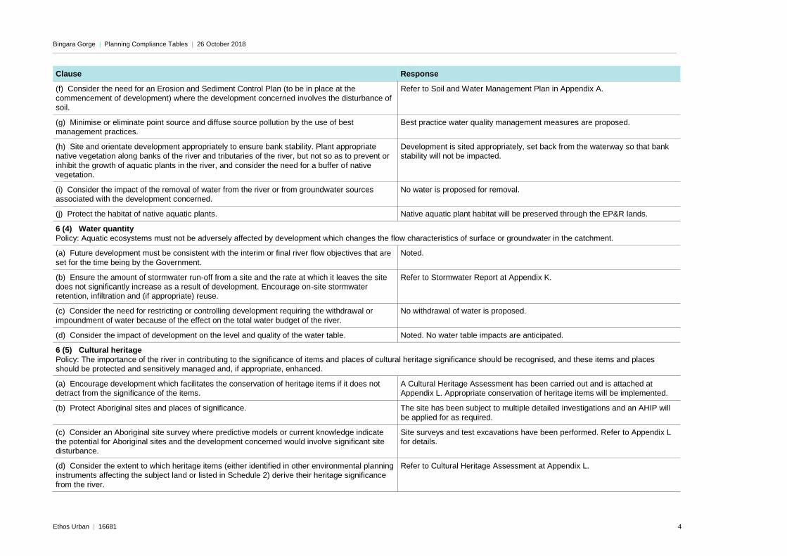
(f) Consider the need for an Erosion and Sediment Control Plan (to be in place at the
commencement of development) where the development concerned involves the disturbance of soil.
Refer to Soil and Water Management Plan in Appendix A.
(g) Minimise or eliminate point source and diffuse source pollution by the use of best management practices.
Best practice water quality management measures are proposed.
(h) Site and orientate development appropriately to ensure bank stability. Plant appropriate
native vegetation along banks of the river and tributaries of the river, but not so as to prevent or
inhibit the growth of aquatic plants in the river, and consider the need for a buffer of native vegetation.
Development is sited appropriately, set back from the waterway so that bank
stability will not be impacted.
(i) Consider the impact of the removal of water from the river or from groundwater sources associated with the development concerned.
No water is proposed for removal.
(j) Protect the habitat of native aquatic plants. Native aquatic plant habitat will be preserved through the EP&R lands.
6 (4) Water quantity
Policy: Aquatic ecosystems must not be adversely affected by development which changes the flow characteristics of surface or groundwater in the catchment.
(a) Future development must be consistent with the interim or final river flow objectives that are
set for the time being by the Government.
Noted.
(b) Ensure the amount of stormwater run-off from a site and the rate at which it leaves the site does not significantly increase as a result of development. Encourage on-site stormwater retention, infiltration and (if appropriate) reuse.
Refer to Stormwater Report at Appendix K.
(c) Consider the need for restricting or controlling development requiring the withdrawal or
impoundment of water because of the effect on the total water budget of the river.
No withdrawal of water is proposed.
(d) Consider the impact of development on the level and quality of the water table. Noted. No water table impacts are anticipated.
6 (5) Cultural heritage
Policy: The importance of the river in contributing to the significance of items and places of cultural heritage significance should be recognised, and these items and places should be protected and sensitively managed and, if appropriate, enhanced.
(a) Encourage development which facilitates the conservation of heritage items if it does not detract from the significance of the items.
A Cultural Heritage Assessment has been carried out and is attached at Appendix L. Appropriate conservation of heritage items will be implemented.
(b) Protect Aboriginal sites and places of significance. The site has been subject to multiple detailed investigations and an AHIP will
be applied for as required.
(c) Consider an Aboriginal site survey where predictive models or current knowledge indicate the potential for Aboriginal sites and the development concerned would involve significant site disturbance.
Site surveys and test excavations have been performed. Refer to Appendix L for details.
(d) Consider the extent to which heritage items (either identified in other environmental planning instruments affecting the subject land or listed in Schedule 2) derive their heritage significance
from the river.
Refer to Cultural Heritage Assessment at Appendix L.

Bingara Gorge | Planning Compliance Tables | 26 October 2018
Ethos Urban | 16681 5
Clause Response
6 (6) Flora and fauna
Policy: Manage flora and fauna communities so that the diversity of species and genetics within the catchment is conserved and enhanced.
Strategies, generally:
(a) Conserve and, where appropriate, enhance flora and fauna communities, particularly
threatened species, populations and ecological communities, aquatic habitats, wetland flora, rare flora and fauna, riverine flora, flora with heritage value, habitats for indigenous and
migratory species of fauna, and existing or potential fauna corridors.
The protection and enhancement of threatened and native flora and fauna has
been considered in the attached VMP.
(b) Locate structures where possible in areas which are already cleared or disturbed instead of
clearing or disturbing further land.
A majority of the Golf Town and Fairways North precincts are partially cleared.
The footprint for development has been previously approved, including concept approval for residential subdivision within these lands. The land is currently zoned for residential development.
(c) Minimise adverse environmental impacts, protect existing habitat and, where appropriate,
restore habitat values by the use of management practices.
A variety of expert reports and management plans have been prepared to
accompany this application, including a Bushland Management Plan, Koala Plan of Management and Vegetation Management Plan. These plans seek to protect existing flora and habitats of fauna through appropriate management
practices.
(d) Consider the impact on ecological processes, such as waste assimilation and nutrient cycling.
This has been considered as part of the proposal and its design.
(e) Consider the range of flora and fauna inhabiting the site of the development concerned and the surrounding land, including threatened species and migratory species, and the impact of the proposal on the survival of threatened species, populations and ecological communities, both in
the short and longer terms.
The impact of the development on Flora and Fauna has been extensively considered throughout the various applications and approvals. Positioning of the fire trails within the EP&R lands will be carried out in accordance with the
LEC approved alignments, so that no additional trees will be cleared. Attached at Appendix O is an Arborist Report relating to the Windrows to be conserved.
(f) Consider the need to provide and manage buffers, adequate fire radiation zones and building
setbacks from significant flora and fauna habitat areas.
Appropriate establishment and management of buffers and APZs have been
included as part of the Bushfire Protection Assessments at Appendix D.
(g) Consider the need to control access to flora and fauna habitat areas. Access to flora and fauna habitat areas within the EP&R zones and ACL is generally limited to fire trails. During construction, these zones will be identified as no-go zones and fenced off with temporary fencing. Refer to the BMP and
VMP for further details.
(h) Consider the need to maintain corridors for fish passage, and protect spawning grounds and gravel beds.
The works as part of the application do not seek any physical works to watercourses that may affect corridors for fish passage.
Strategies for wetlands:
(i) Maintain the ability of wetlands to improve the quality of water entering the river through the filtering of sediments and the absorption of nutrients.
N/A – there are no wetlands in proximity to the site, nor that will be affected by development of the site.
(j) Maintain the ability of wetlands to stabilise soils and reduce bank erosion. N/A
Bingara Gorge | Planning Compliance Tables | 26 October 2018
Ethos Urban | 16681 6
Clause Response
(k) Maintain the ability of wetlands to reduce the impact of flooding downstream through the
retention of floodwaters.
N/A
(l) Maintain a variety of wetland flora and fauna species in the region and consider the scarcity
of particular species on a national basis.
N/A
(m) Encourage the appropriate management of wetlands, including monitoring and weed control.
N/A
(n) Provide opportunities for recreation, scientific research and education where they are compatible with the conservation of wetlands.
N/A
(o) Consider the need to protect and improve the quality and quantity of surface water and
groundwater entering wetlands by controlling development in the catchment of wetlands.
N/A
(p) Consider the desirability of protecting any wetlands of local significance which are not included on the map.
N/A
(q) Consider the desirability of protecting or, if necessary, actively managing, constructed wetlands if they have significant conservation values or make a significant contribution to improvements in water quality.
N/A
6 (7) Riverine scenic quality
Policy: The scenic quality of the riverine corridor must be protected.
(a) Maintain areas of extensive, prominent or significant vegetation to protect the character of the river.
Extensive areas of existing vegetation are being preserved in close proximity to Stringybark and Allen’s Creek. The scenic/visual character of these tributaries will be preserved. Vegetation removal has been approved under the
LEC Consent Orders. No additional vegetation removal in proximity to the creeks is proposed in this application.
(b) Ensure proposed development is consistent with the landscape character as described in the Scenic Quality Study.
N/A
(c) Consider the siting, setback, orientation, size, bulk and scale of and the use of unobtrusive, non-reflective material on any proposed building or work, the need to retain existing vegetation,
especially along river banks, slopes visible from the river and its banks and along the skyline, and the need to carry out new planting of trees, and shrubs, particularly locally indigenous plants.
No building structures are proposed as part of this application. Residential subdivision, road works etc. have been appropriately located away from
waterways, which are buffered by environmental protection/conservation zones.
(d) Consider the need for a buffer between new development and scenic areas of the riverine
corridor shown on the map as being of significance beyond the region (which are also scenic areas of significance for the region) or so shown as being of regional significance only.
As above.
(e) Consider the need for controls or conditions to protect those scenic areas. Scenic and vegetation buffer areas will be appropriately protected through implementation of the strategies and management plans in the BMP, VMP and
KPoM.
(f) Consider opportunities to improve riverine scenic quality. N/A

Bingara Gorge | Planning Compliance Tables | 26 October 2018
Ethos Urban | 16681 7
Clause Response
6 (8) Agriculture/aquaculture and fishing
Policy: Agriculture must be planned and managed to minimise adverse environmental impacts and be protected from adverse impacts of other forms of development.
(a) Give priority to agricultural production in rural zones. Land is zoned for residential use.
(b) Ensure zone objectives and minimum lot sizes support the continued agricultural use of
Class 1, 2 and 3 Agricultural Land (as defined in the Department of Agriculture’s Agricultural Land Classification Atlas) and of any other rural land that is currently sustaining agricultural
production.
Land is zoned for residential use. The proposed subdivision is consistent with
the minimum lot sizes in the WLEP.
(c) Incorporate effective separation between intensive agriculture and adjoining uses to mitigate
noise, odour and visual impacts.
No intensive agriculture uses are proposed on site or exist in close proximity to
the site.
(d) Protect agricultural sustainability from the adverse impacts of other forms of proposed development.
No agriculture uses are proposed on site or exist in close proximity to the site.
(e) Consider the ability of the site to sustain over the long term the development concerned. The ability of the site to sustain the level of development that will be facilitated by the proposed subdivision was considered and approved in the consent
orders from LEC case 158921 of 2016.
(f) Consider the likely effect of the development concerned on fish breeding grounds, nursery
areas, commercial and recreational fishing areas and oyster farming.
N/A
6 (9) Rural residential development Policy: Rural residential development should not reduce agricultural sustainability, contribute to urban sprawl, or have adverse environmental impacts (particularly on the water cycle or on flora or fauna).
(a) Give priority to agricultural production in rural zones. N/A – land is zoned for residential use.
(b) When considering a proposal for the rezoning or subdivision of land which will increase the
intensity of development of rural land (for example, by increasing cleared or hard surface areas) so that effluent equivalent to that produced by more than 20 people will be generated, consider requiring the preparation of a Total Water Cycle Management Study or Plan
N/A
(c) Maintain or introduce appropriate separation between rural residential use and agricultural use on the land that is proposed for development.
N/A
(d) Do not locate development in areas identified for future urban purposes in the Metropolitan
Strategy.
N/A
(e) Consider the suitability of the land for keeping livestock, whether or not for commercial purposes, and appropriate mitigating measures to prevent land degradation.
N/A
(f) Consider the ability of the land to accommodate on-site effluent disposal in the long term. N/A
(g) Consider any adverse environmental impacts of infrastructure associated with the development concerned.
N/A
6 (10) Urban development Policy: All potential adverse environmental impacts of urban development must be assessed and controlled.
Bingara Gorge | Planning Compliance Tables | 26 October 2018
Ethos Urban | 16681 8
Clause Response
(a) When considering a proposal for the rezoning or subdivision of land which will increase the
intensity of development of that land (for example, by increasing cleared or hard surface areas) so that effluent equivalent to that produced by more than 2,500 people will be generated, consider requiring the preparation of a Total Water Cycle Management Study or Plan.
The proposal does not seek to increase the intensity of development at the
site. Development potential as per this application was granted concept approval in the consent orders made in the LEC case 158921 of 2016.
(b) Consider urban design options to reduce environmental impacts (such as variable lot sizes and shapes, and the clustering of development).
Lot sizes vary substantially, from 375sqm to over 1,000sqm. The shape of lots also varies substantially, generally following and responding to the undulating
form of the surrounding land, golf course and waterways.
6 (11) Recreation and tourism Policy: The value of the riverine corridor as a significant recreational and tourist asset must be protected.
(a) Provide a wide range of recreational opportunities along the river which are consistent with conserving the river’s natural values and character.
The primary recreational opportunity near the river is the existing golf course. The golf course accentuates the feeling of being in nature, responding to the
value of the surrounding riverine corridors. Further recreation activities are expected to comprise cycling and walking through the residential area and also the fire trails within the environmental protection lands.
(b) Plan and manage recreational and tourist developments, and associated access points,
cycleways and footpaths, so as to minimise any adverse environmental impacts on the river. Locate them where river banks are stable, away from river shallows, major beds of attached aquatic plants or fish breeding areas, where the proposed activities do not conflict with
surrounding recreational activities and where significant flora and fauna habitats will not be adversely affected. The upgrading of existing public access to the river is to be preferred over the creation of new access points.
Fire trails have been located sensitively so as to minimise impact on the
riverine areas and allow for appropriate protection against bushfires. Management of these trails is outlined in the attached VMP and BMP.
(c) Minimise conflicts between recreational uses. N/A
(d) Consider the availability of, or need to provide, land for vehicle parking and for suitable access (including access for cars and buses), for boat service areas and for water, electricity
and sewage disposal.
N/A
(e) Consider the environmental impact of ancillary services for recreation and tourist developments, such as amenities blocks and vehicle parking.
N/A
(f) Consider the visual impact of development on the surrounding area. No building structures are proposed in this application.
6 (12) Metropolitan strategy Policy: Development should complement the vision, goal, key principles and action plan of the Metropolitan Strategy.
(a) Consider the impacts of transport infrastructure proposals on water quality and air quality. No transport infrastructure is proposed other than local roads.
(b) Consider the impacts of metropolitan waste disposal on water quality. Waste will be managed through private contractors and is not anticipated to impact on water quality.
(c) Consider the impacts of development on air quality. The proposed development will utilise a CEMP to manage air quality impacts.
(d) Consider the need for waste avoidance, waste reduction, reuse and recycling measures. Noted. General waste management measures will be implemented.
Bingara Gorge | Planning Compliance Tables | 26 October 2018
Ethos Urban | 16681 9
Clause Response
(e) Consider the implications of predicted climate change on the location of development and its
effect on conservation of natural resources.
Noted. Climate change has been considered as part of the design process.
Part 3 Development controls
8 Development controls
(1) Prohibited development
Development defined in an item in clause 11 that is prohibited is indicated in the item by the word Prohibited.
N/A
(2) Development requiring consent Any such development that may be carried out only with development consent is indicated in the
item by the words Consent required. The council of the area in which development is proposed to be carried out is the consent authority for that development for the purposes of this plan, except where the Act provides otherwise.
Noted.
(3) Development requiring concurrence
Any such development that may be carried out only with development consent granted with the concurrence of the Director is indicated in the item by the word Concurrence, together with a reference to the Director.
Noted.
(5) Development requiring certain matters to be considered The consent authority must not grant consent to the carrying out of any such development if the
words Additional matters for consideration by the consent authority appear in the item until it has considered those matters in addition to the matters specified in section 90 of the Act.
Matters that must be considered by the Director, if the Director’s concurrence to a grant of consent is required by this plan, in determining whether to grant that concurrence are indicated in the Table by the words Matters for consideration by the concurrence authority.
Noted.
(6) Development for which consent may be granted in special circumstances
Any circumstances in which consent may be granted to the carrying out of the particular development even though the development is not in accordance with the other provisions of this plan are indicated in the item by the words Special circumstances.
Noted.
(7) Designated development
Any such development declared to be designated development for the purposes of the Act is indicated in the item by the words Designated development.
Not applicable.
10 Excepted land
This Part does not apply to land reserved or dedicated under the National Parks and Wildlife Act 1974 or dedicated under the Forestry Act 1916.
Noted.
11 Development controls The following items set out particulars for the development controls imposed by this Part:
Noted.

Bingara Gorge | Planning Compliance Tables | 26 October 2018
Ethos Urban | 16681 10
Clause Response
(3) Buildings, works or land uses within conservation area sub-catchments
Note. Conservation area subcatchments are those that are subject to relatively minimal human
interference and are consequently in a reasonably pristine environmental condition. Definition:
Development for the purpose of any building, work or land use, including clearing, in the sub-catchments of Glenbrook and Erskine Creek, Webbs Creek, the Colo River, the Grose River and the Macdonald River, as shown on the map, except for buildings, works or land uses that the
consent authority considers to be minor and do not involve clearing or on-site effluent disposal. Consent required.
Additional matters for consideration by the consent authority: The need to prevent adverse impacts on the near pristine condition of these sub-catchments.
Noted.
(4) Remediation of contaminated land
Definition: Removing soil or other deposits from, or otherwise remediating, contaminated land. For the purposes of this definition, contaminated land means land on which hazardous substances
occur at concentration levels above background levels, where an assessment (carried out in accordance with guidelines circulated to councils by the Department) has indicated the substances pose, or are likely to pose, an immediate or long-term hazard to human health or to
the environment. Consent required.
Potential remediation will be required if any unexpected finds occur.
(7) Filling
Definition: Filling of land, including submerged aquatic land, by raising the ground level through disposal of
spoil from any landfill method (such as mining, dredging or refuse dumping), whether or not to enable the construction of a road or the erection of buildings or pylons or any other structure, where filling exceeds 1 metre in depth, or an area of 100 square metres.
Consent required.
Noted. Minor filling works are required.
Bingara Gorge | Planning Compliance Tables | 26 October 2018
Ethos Urban | 16681 11
Clause Response
(17) Sewerage systems or works
Definition: Development for the purpose of any sewerage system or work which stores, treats or disposes
of sewage (including domestic on-site disposal systems that are ancillary to development which requires consent) but not including a public utility undertaking.
Consent required. Additional matters for consideration by the consent authority:
(a) Whether the proposed development will be capable of connection to a Sydney Water Corporation Limited or council sewerage system either now or in the future. (b) The suitability of the site for on-site disposal of effluent or sludge and the ability of the
sewerage systems or works to operate over the long-term without causing significant adverse effects on adjoining property. (c) The likely effect of any on-site disposal area required by the proposed development on:
• any water bodies in the vicinity (including dams, streams and rivers), or • any mapped wetlands, or • any groundwater, or
• the floodplain. (d) The scope for recycling and reusing effluent or sludge on the site. (e) The adequacy of wet weather storage and the wet weather treatment capacity (if relevant) of
the proposed sewerage system or works. (f) Downstream effects of direct discharge of effluent to watercourses. (g) The need for ongoing monitoring of the system or work.
N/A
Bingara Gorge | Planning Compliance Tables | 26 October 2018
Ethos Urban | 16681 12
2.0 Wollondilly Local Environmental Plan 2011
Table 2 Compliance with Wollondilly Local Environmental Plan 2011
Control Description Compliance
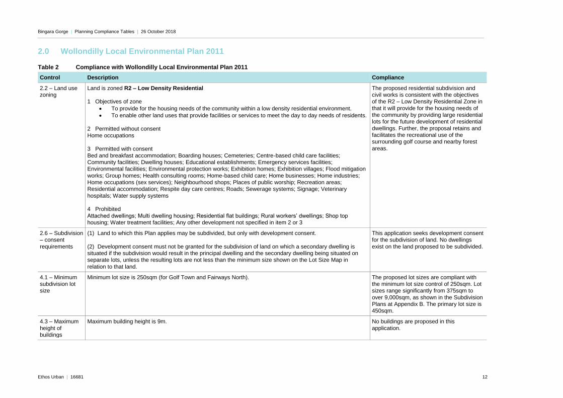
2.2 – Land use zoning
Land is zoned R2 – Low Density Residential 1 Objectives of zone
• To provide for the housing needs of the community within a low density residential environment.
• To enable other land uses that provide facilities or services to meet the day to day needs of residents. 2 Permitted without consent
Home occupations 3 Permitted with consent
Bed and breakfast accommodation; Boarding houses; Cemeteries; Centre-based child care facilities; Community facilities; Dwelling houses; Educational establishments; Emergency services facilities; Environmental facilities; Environmental protection works; Exhibition homes; Exhibition villages; Flood mitigation
works; Group homes; Health consulting rooms; Home-based child care; Home businesses; Home industries; Home occupations (sex services); Neighbourhood shops; Places of public worship; Recreation areas; Residential accommodation; Respite day care centres; Roads; Sewerage systems; Signage; Veterinary
hospitals; Water supply systems 4 Prohibited
Attached dwellings; Multi dwelling housing; Residential flat buildings; Rural workers’ dwellings; Shop top housing; Water treatment facilities; Any other development not specified in item 2 or 3
The proposed residential subdivision and civil works is consistent with the objectives of the R2 – Low Density Residential Zone in
that it will provide for the housing needs of the community by providing large residential lots for the future development of residential
dwellings. Further, the proposal retains and facilitates the recreational use of the surrounding golf course and nearby forest
areas.
2.6 – Subdivision – consent
requirements
(1) Land to which this Plan applies may be subdivided, but only with development consent.
(2) Development consent must not be granted for the subdivision of land on which a secondary dwelling is situated if the subdivision would result in the principal dwelling and the secondary dwelling being situated on
separate lots, unless the resulting lots are not less than the minimum size shown on the Lot Size Map in
relation to that land.
This application seeks development consent for the subdivision of land. No dwellings
exist on the land proposed to be subdivided.
4.1 – Minimum subdivision lot size
Minimum lot size is 250sqm (for Golf Town and Fairways North).
The proposed lot sizes are compliant with the minimum lot size control of 250sqm. Lot sizes range significantly from 375sqm to
over 9,000sqm, as shown in the Subdivision Plans at Appendix B. The primary lot size is 450sqm.
4.3 – Maximum
height of buildings
Maximum building height is 9m. No buildings are proposed in this
application.

Bingara Gorge | Planning Compliance Tables | 26 October 2018
Ethos Urban | 16681 13
Control Description Compliance
5.10 – Heritage
conservation
Item of local Aboriginal heritage I285 – Aboriginal shelter sites is in the vicinity of the proposal A Cultural Heritage Assessment has been
prepared by Kayandel (Appendix L). Appropriate conservation of Aboriginal heritage items is detailed within the report
and the SEE.
6.1 –
Arrangements for designated State public
infrastructure
A Voluntary Planning Agreement applies across the site. Noted.
6.2 – Public utility infrastructure
A Voluntary Planning Agreement applies across the site. Noted.
6.3 –
Development control plan
Refer to Table 3 for assessment against the provisions contained in the Wollondilly DCP.
7.1 – Essential services
As per 7.1(2)(b), this clause does not apply to the site since it is located within the Wilton Urban Release Area.
7.2 – Biodiversity
protection
(1) The objective of this clause is to maintain terrestrial and aquatic biodiversity including:
(a) protecting native fauna and flora, and (b) protecting the ecological processes necessary for their continued existence, and (c) encouraging the recovery of native fauna and flora and their habitats, and
(d) protecting water quality within drinking water catchments. (2) This clause applies to land identified as “sensitive land” on the Natural Resources—Biodiversity Map. (3) Before determining a development application for land to which this clause applies, the consent authority
must consider any adverse impact of the proposed development on the following: (a) native ecological communities, (b) the habitat of any threatened species, populations or ecological community,
(c) regionally significant species of fauna and flora or habitat, (d) habitat elements providing connectivity, (e) water quality within drinking water catchments.
(4) Development consent must not be granted to development on land to which this clause applies unless the consent authority is satisfied that: (a) the development is designed, sited and will be managed to avoid any adverse environmental impact, or
(b) if that impact cannot be avoided—the development is designed, sited and will be managed to minimise that impact, or (c) if that impact cannot be minimised—the development will be managed to mitigate that impact.
The development has been designed and
sited, and will be managed, to reduce potential environmental impacts. EP&R and conservation lands are proposed and
residential subdivision occurs outside of these zones. Refer to the various ecological reports
accompanying this application for further detail.

Bingara Gorge | Planning Compliance Tables | 26 October 2018
Ethos Urban | 16681 14
Control Description Compliance
7.3 – Water
protection
(1) The objective of this clause is to maintain the hydrological functions of riparian land, waterways and
aquifers, including protecting the following: (a) water quality, (b) natural water flows,
(c) the stability of the bed and banks of waterways, (d) groundwater systems. (2) This clause applies to land identified as “sensitive land” on the Natural Resources—Water Map.
(3) Before determining a development application for development on land to which this clause applies, the consent authority must consider any adverse impact of the proposed development on the following: (a) the water quality of receiving waters,
(b) the natural flow regime, (c) the natural flow paths of waterways, (d) the stability of the bed, shore and banks of waterways,
(e) the flows, capacity and quality of groundwater systems. (4) Development consent must not be granted to development on land to which this clause applies unless the consent authority is satisfied that:
(a) the development is designed, sited and will be managed to avoid any adverse environmental impact, or (b) if that impact cannot be avoided—the development is designed, sited and will be managed to minimise that impact, or
(c) if that impact cannot be minimised—the development will be managed to mitigate that impact.
Complies. Refer to Civil Engineering Plans
at Appendix A and the Stormwater Assessment at Appendix K.
7.4 – Flood
planning
(1) The objectives of this clause are as follows:
(a) to minimise the flood risk to life and property associated with the use of land, (b) to allow development on land that is compatible with the land’s flood hazard, taking into account projected changes as a result of climate change,
(c) to avoid significant adverse impacts on flood behaviour and the environment. (2) This clause applies to land that is at or below the flood planning level. (3) Development consent must not be granted to development on land to which this clause applies unless the
consent authority is satisfied that the development: (a) is compatible with the flood hazard of the land, and (b) is not likely to significantly adversely affect flood behaviour resulting in detrimental increases in the
potential flood affectation of other development or properties, and (c) incorporates appropriate measures to manage risk to life from flood, and (d) is not likely to significantly adversely affect the environment or cause avoidable erosion, siltation,
destruction of riparian vegetation or a reduction in the stability of river banks or watercourses, and (e) is not likely to result in unsustainable social and economic costs to the community as a consequence of flooding.
(4) A word or expression used in this clause has the same meaning as it has in the Floodplain Development Manual (ISBN 0 7 347 54760) published in 2005 by the NSW Government, unless it is otherwise defined in this clause.
(5) In this clause, flood planning level means the level of a 1:100 ARI (average recurrent interval) flood event plus 0.5 metre freeboard.
As above.

Bingara Gorge | Planning Compliance Tables | 26 October 2018
Ethos Urban | 16681 15
Control Description Compliance
7.5 – Earthworks (1) The objectives of this clause are as follows:
(a) to ensure that earthworks for which development consent is required will not have a detrimental impact on environmental functions and processes, neighbouring uses, cultural or heritage items or features of the surrounding land,
(b) to allow earthworks of a minor nature without requiring separate development consent. (2) Development consent is required for earthworks unless: (a) the work is exempt development under this Plan or another applicable environmental planning
instrument, or (b) the work is ancillary to other development for which development consent has been given. (3) Before granting development consent for earthworks, the consent authority must consider the following
matters: (a) the likely disruption of, or any detrimental effect on, existing drainage patterns and soil stability in the locality,
(b) the effect of the proposed development on the likely future use or redevelopment of the land, (c) the quality of the fill or the soil to be excavated, or both, (d) the effect of the proposed development on the existing and likely amenity of adjoining properties,
(e) the source of any fill material and the destination of any excavated material, (f) the likelihood of disturbing relics, (g) the proximity to and potential for adverse impacts on any watercourse, drinking water catchment or
environmentally sensitive area.
Refer to Civil Engineering Plans at Appendix
A.
3.0 Wollondilly Development Control Plan 2016
Table 3 Compliance with Wollondilly Development Control Plan 2016
Control Description Compliance
Volume 1 – General
Part 2 – General Considerations for All Development
2.1 Objectives 1. To ensure that developments are undertaken with due regard to human safety.
2. To ensure that developments do not unreasonably impact on their surrounds.
3. To ensure that developments achieve a satisfactory level of social equity.
The proposal is consistent with the objectives of the
DCP in that it: - Has been designed to have high regard
for human safety through bushfire,
flooding and road safety considerations; and
- Has extensively considered the impact on
the surroundings of the site.
Bingara Gorge | Planning Compliance Tables | 26 October 2018
Ethos Urban | 16681 16
Control Description Compliance
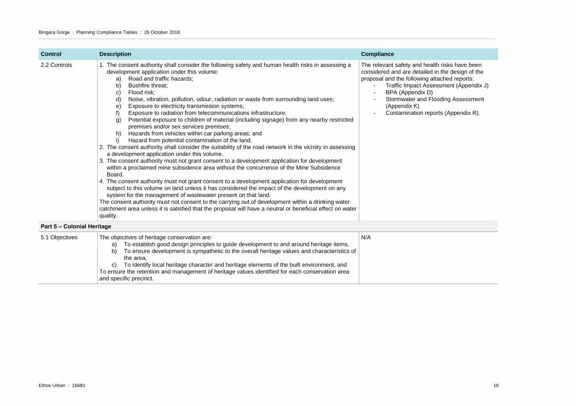
2.2 Controls 1. The consent authority shall consider the following safety and human health risks in assessing a
development application under this volume: a) Road and traffic hazards; b) Bushfire threat;
c) Flood risk; d) Noise, vibration, pollution, odour, radiation or waste from surrounding land uses; e) Exposure to electricity transmission systems;
f) Exposure to radiation from telecommunications infrastructure; g) Potential exposure to children of material (including signage) from any nearby restricted
premises and/or sex services premises;
h) Hazards from vehicles within car parking areas; and i) Hazard from potential contamination of the land.
2. The consent authority shall consider the suitability of the road network in the vicinity in assessing
a development application under this volume. 3. The consent authority must not grant consent to a development application for development
within a proclaimed mine subsidence area without the concurrence of the Mine Subsidence
Board. 4. The consent authority must not grant consent to a development application for development
subject to this volume on land unless it has considered the impact of the development on any
system for the management of wastewater present on that land. The consent authority must not consent to the carrying out of development within a drinking water catchment area unless it is satisfied that the proposal will have a neutral or beneficial effect on water
quality.
The relevant safety and health risks have been
considered and are detailed in the design of the proposal and the following attached reports:
- Traffic Impact Assessment (Appendix J)
- BPA (Appendix D) - Stormwater and Flooding Assessment
(Appendix K)
- Contamination reports (Appendix R).
Part 5 – Colonial Heritage
5.1 Objectives The objectives of heritage conservation are:
a) To establish good design principles to guide development to and around heritage items, b) To ensure development is sympathetic to the overall heritage values and characteristics of
the area,
c) To identify local heritage character and heritage elements of the built environment, and To ensure the retention and management of heritage values identified for each conservation area and specific precinct.
N/A

Bingara Gorge | Planning Compliance Tables | 26 October 2018
Ethos Urban | 16681 17
Control Description Compliance
5.2 General Controls Development of heritage items and development on land within heritage conservation areas shall
demonstrate consistency with the NSW Guidelines for Development in Conservation Areas ‘Design in Context’. In particular the impact of the following aspects of a development should be considered:
• Height and scale - must respect the predominant scale (building height, bulk, density and massing) of the heritage buildings in the vicinity in order to retain the prevailing scale of
the Conservation Area. The impact of an inappropriately scaled building cannot be compensated for by building form, design or detailing.
• View corridors - must be retained to and from significant features within the Conservation
Area.
• Architectural style and form - must be compatible with the existing heritage buildings in the vicinity.
• Materials, detailing and colour schemes - must respect the materials of the existing heritage buildings in the vicinity.
• Siting - must respect existing patterns of building setbacks of heritage buildings from property boundaries, which contribute to the harmony of the streetscape.
• Cumulative impact - must be considered to ensure that the characteristic features of the conservation area that give harmony and cohesiveness to streetscapes and individual buildings are not eroded.
No buildings are proposed as part of this
application.
5.3.4 Controls for
particular development types: Subdivision of land
containing a heritage item and/or land within a heritage
conservation area
1. Must not compromise or adversely affect any historic layout of the subject lot and heritage
significance of the original lot pattern. 2. Must not compromise the curtilage of any heritage item or significant complimentary building,
garden, driveway or other relic.
3. Where a heritage impact assessment is required, it must consider the likely location of future buildings and/or building envelopes.
N/A
Part 6 – Heritage (Specific Locations)
N/A
Part 7 – Aboriginal Heritage
7.1 Objectives a) To achieve appropriate means of conservation, management and protection for archaeological
sites, Aboriginal objects and Aboriginal places of heritage significance. b) To achieve compliance with the requirements of the National Parks and Wildlife Act, 1974 and
associated Regulations and guidelines with respect to Aboriginal objects and Aboriginal places of
heritage significance. c) To consider and manage Aboriginal objects and Aboriginal places of heritage significance at the
earliest practical stages in the land development process.
Refer to Cultural Heritage Assessment (Appendix L)
and Conservation Management Statement (Appendix M).
An AHIP will be acquired for the relevant objects as recommended by the abovementioned reports.

Bingara Gorge | Planning Compliance Tables | 26 October 2018
Ethos Urban | 16681 18
Control Description Compliance
7.2 Controls An indigenous heritage and archaeological report must be prepared for any development
application on land which contains a known Aboriginal object or Aboriginal place of heritage significance. The report must be prepared by a suitably qualified archaeologist. The report must be prepared in accordance with the Code of Practice for Archaeological Investigation of Aboriginal
objects in NSW. A report may also be required at the discretion of the assessing officer where: 1. There is impact or disturbance to the content, or within the immediate vicinity (100 metres) of a
known Aboriginal object or Aboriginal place of heritage significance; 2. There is impact or disturbance to, or within the immediate vicinity (100 metres) of a previously
recorded or known Aboriginal object or Aboriginal place of heritage significance and can include
a cultural landscape, an existing or former ceremonial ground, a burial ground or cemetery, a story place or mythological site, a former Aboriginal reserve or historic encampment, or an archaeological site of high significance;
3. A proposal (including subdivision) which affects primarily undeveloped land (irrespective of land size) and has the following site features:
a. river frontage
b. creek line c. sandstone exposures at ground level larger than 5m² d. sandstone cliff line or isolated boulder higher than 2m
e. disturbance to the roots, trunk, branches, of old growth trees, which are native to the Wollondilly Shire and greater than 150 years of age.
4. Ensure that all works cease in the vicinity of any previously unidentified Aboriginal objects or
places identified during excavation and construction and that the following be notified a. The Office of Environment and Heritage NSW (OEH) b. A qualified archaeologist
c. Aboriginal stakeholders. 5. Ensure that should human skeletal remains be discovered that the following process will
be undertaken:
a. The remains will be reported to the police and the state coroner.
b. Wollondilly Shire Council and the land owner will be notified of the find. c. Aboriginal stakeholders will be notified of the find. OEH NSW will be notified.
6. If the skeletal remains are of Aboriginal ancestral origin an appropriate management strategy will be developed in consultation with the Aboriginal stakeholders.
7. The find will be recorded in accordance with the National Parks and Wildlife Act 1974 (NSW) and
the NSW NPWS Aboriginal Cultural Heritage Standards and Guidelines Kit. 8. The finding’s will be incorporated into any Aboriginal Heritage Management Plan’s management
regime.
As above.
A Conservation Management Plan for the Bingara Gorge Site has been prepared and is attached at Appendix M.
Part 8 – Flooding
8.1 Objective To reduce the impact of flooding and flood liability on individual owners and occupiers of flood prone property, and to reduce private and public losses resulting from floods, utilising ecologically positive
methods wherever possible.
Noted. The site has been subject to flood assessment as part of the LEC Court case.
Bingara Gorge | Planning Compliance Tables | 26 October 2018
Ethos Urban | 16681 19
Control Description Compliance
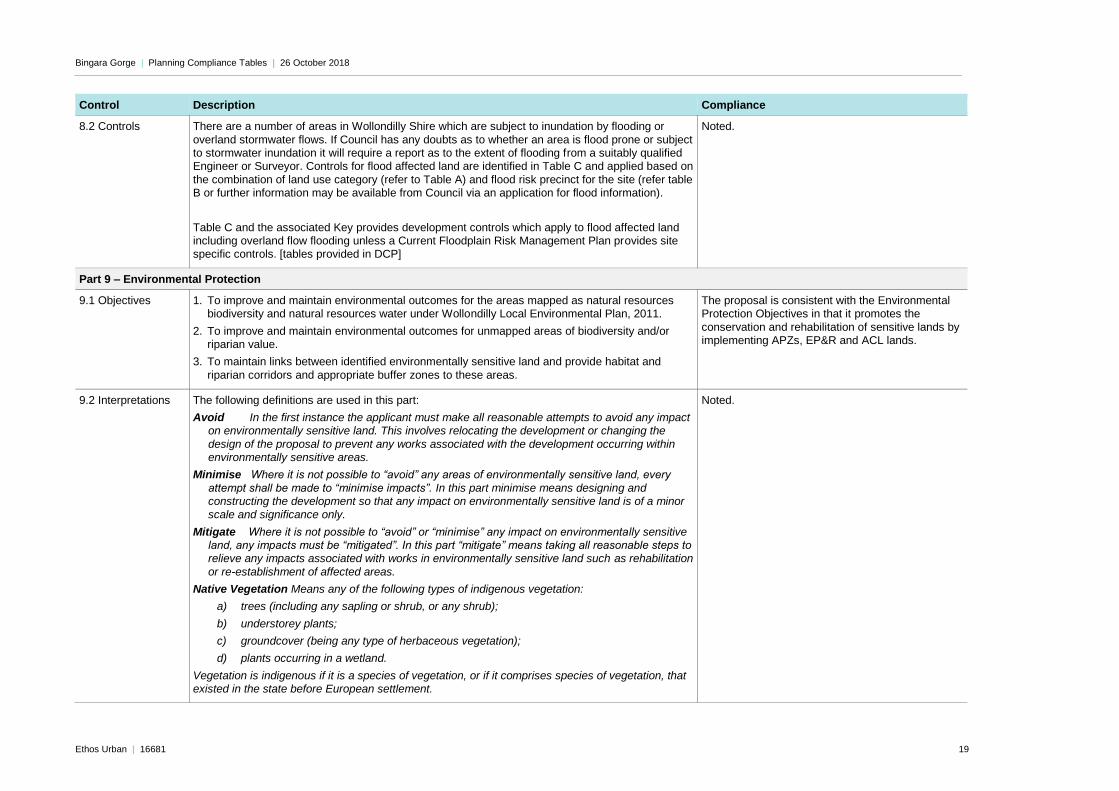
8.2 Controls There are a number of areas in Wollondilly Shire which are subject to inundation by flooding or
overland stormwater flows. If Council has any doubts as to whether an area is flood prone or subject to stormwater inundation it will require a report as to the extent of flooding from a suitably qualified Engineer or Surveyor. Controls for flood affected land are identified in Table C and applied based on
the combination of land use category (refer to Table A) and flood risk precinct for the site (refer table B or further information may be available from Council via an application for flood information).
Table C and the associated Key provides development controls which apply to flood affected land including overland flow flooding unless a Current Floodplain Risk Management Plan provides site specific controls. [tables provided in DCP]
Noted.
Part 9 – Environmental Protection
9.1 Objectives 1. To improve and maintain environmental outcomes for the areas mapped as natural resources biodiversity and natural resources water under Wollondilly Local Environmental Plan, 2011.
2. To improve and maintain environmental outcomes for unmapped areas of biodiversity and/or riparian value.
3. To maintain links between identified environmentally sensitive land and provide habitat and
riparian corridors and appropriate buffer zones to these areas.
The proposal is consistent with the Environmental Protection Objectives in that it promotes the
conservation and rehabilitation of sensitive lands by implementing APZs, EP&R and ACL lands.
9.2 Interpretations The following definitions are used in this part:
Avoid In the first instance the applicant must make all reasonable attempts to avoid any impact on environmentally sensitive land. This involves relocating the development or changing the
design of the proposal to prevent any works associated with the development occurring within environmentally sensitive areas.
Minimise Where it is not possible to “avoid” any areas of environmentally sensitive land, every
attempt shall be made to “minimise impacts”. In this part minimise means designing and constructing the development so that any impact on environmentally sensitive land is of a minor
scale and significance only.
Mitigate Where it is not possible to “avoid” or “minimise” any impact on environmentally sensitive land, any impacts must be “mitigated”. In this part “mitigate” means taking all reasonable steps to relieve any impacts associated with works in environmentally sensitive land such as rehabilitation
or re-establishment of affected areas.
Native Vegetation Means any of the following types of indigenous vegetation:
a) trees (including any sapling or shrub, or any shrub);
b) understorey plants;
c) groundcover (being any type of herbaceous vegetation);
d) plants occurring in a wetland.
Vegetation is indigenous if it is a species of vegetation, or if it comprises species of vegetation, that existed in the state before European settlement.
Noted.

Bingara Gorge | Planning Compliance Tables | 26 October 2018
Ethos Urban | 16681 20
9.3 Controls 1. Development carried out on areas mapped as ‘sensitive land’ on the Natural Resources –
Biodiversity Map and the Natural Resources Water Map under Wollondilly Local Environmental Plan, 2011 shall occur so as to either avoid, minimise or mitigate any adverse impact as detailed in Clause 7.2 and 7.3 of Wollondilly Local Environmental Plan 2011.
2. If a development is not able to avoid, minimise or mitigate an adverse impact on sensitive land mapped on the Natural Resources Biodiversity Map, the vegetation shall not be cleared or otherwise disturbed unless the impacts are offset through biobanking or a similar conservation
agreement
3. The consent authority shall not grant consent to any development that would result in the clearing or other disturbance of an environmental asset unless it is satisfied that any adverse impacts will
be offset through bio banking or a similar environmental conservation arrangement.
4. Any development application on a site that includes sensitive land mapped on the Natural Resources – Water map under Wollondilly Local Environmental Plan, 2011 with a riparian buffer
distance, must include an accurate survey of riparian buffer distances to determine the exact location of the buffer which is to be measured from the top of bank of each side of the watercourse. It should be noted that the LEP maps are indicative and based on watercourse
centre lines. These maps do not identify the location of the top of banks of watercourses as it is not the intent of the map to show this and the position of watercourse centre lines shown is only approximate. The map seeks to identify what buffer distance is to be applied to each watercourse
and not the extent of that buffer on the ground.
5. All stormwater generated from any development shall be treated to an acceptable standard to maintain water quality. In determining the “acceptable standard” the consent authority shall be
mindful of the relevant guidelines of the State and Federal Governments. This treatment must be undertaken outside any areas mapped as sensitive land in the Natural Resources – Water map under Wollondilly Local Environmental Plan, 2011.
6. Nothing in this section prevents minor works on environmental land for the purposes of providing infrastructure.
7. Where a development is proposed on sites which do not contain areas mapped on the Natural
Resources Water or Natural Resources Biodiversity maps and contain native vegetation, the
development shall be located in accordance with the following (in order of preference):
a. on cleared parts of the site wherever possible; or
b. in locations where the least amount of vegetation removal would be required (e.g. close to roads) if the development is not able to be located wholly in a cleared area; or
c. If the development is not able to be located wholly in a cleared area, then the
development should be located on parts of the site in which the vegetation is determined as being of the least significance and recovery potential.
8. This includes consideration of vegetation removal for any main buildings, ancillary buildings,
asset protection zones, effluent disposal areas and access driveways that may be required for the development.
9. In cases where native vegetation removal is required a flora and fauna report from an
appropriately qualified ecologist may be required to satisfy compliance with any of the controls listed above.
The proposed residential subdivision and civil works
is located outside of areas mapped as sensitive land.
Pedestrian fire trails are the only proposed development that will occur within the sensitive land, and the alignment and design of these trails
has been considered and approved under the LEC consent orders (refer to Appendix C2).
Vegetation clearing, other than for the fire trails, is located outside the mapped sensitive land and has been approved in concept under the LEC consent
orders. Stormwater and Flooding design has been
considered – refer to Consent Orders at Appendix C2 and Letters of Compliance at Appendix K.
Bingara Gorge | Planning Compliance Tables | 26 October 2018
Ethos Urban | 16681 21
Control Description Compliance
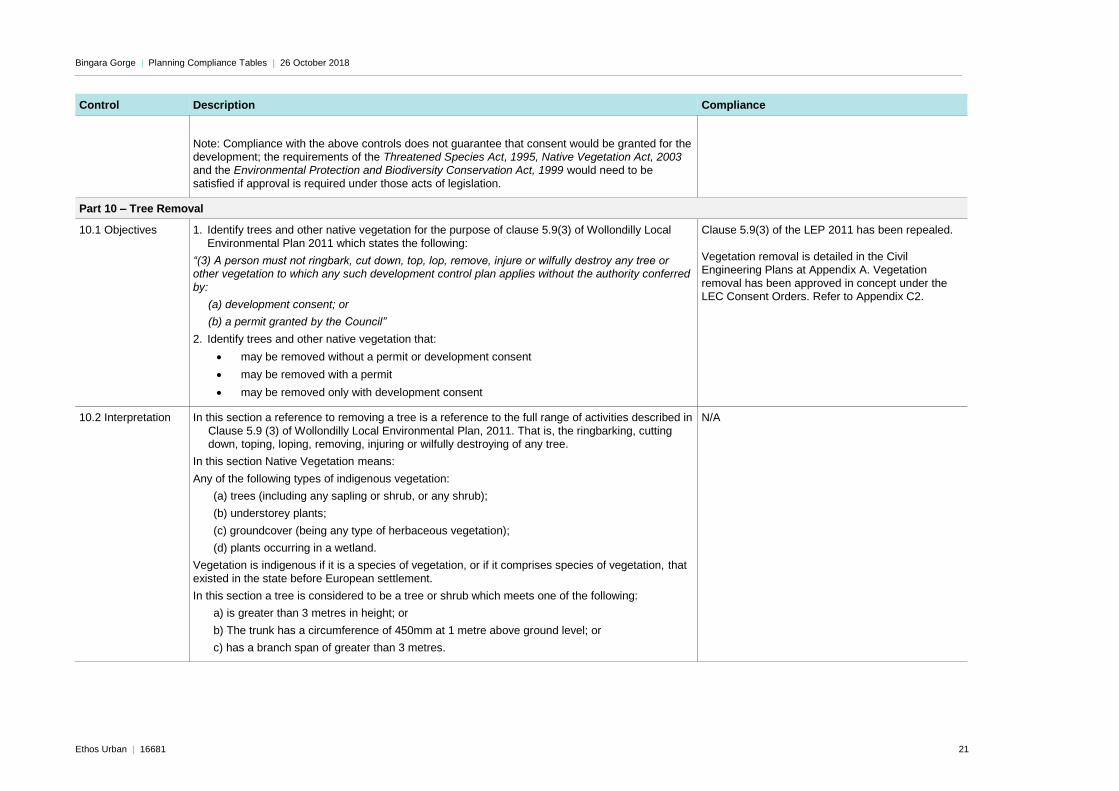
Note: Compliance with the above controls does not guarantee that consent would be granted for the development; the requirements of the Threatened Species Act, 1995, Native Vegetation Act, 2003 and the Environmental Protection and Biodiversity Conservation Act, 1999 would need to be
satisfied if approval is required under those acts of legislation.
Part 10 – Tree Removal
10.1 Objectives 1. Identify trees and other native vegetation for the purpose of clause 5.9(3) of Wollondilly Local
Environmental Plan 2011 which states the following:
“(3) A person must not ringbark, cut down, top, lop, remove, injure or wilfully destroy any tree or other vegetation to which any such development control plan applies without the authority conferred
by:
(a) development consent; or
(b) a permit granted by the Council”
2. Identify trees and other native vegetation that:
• may be removed without a permit or development consent
• may be removed with a permit
• may be removed only with development consent
Clause 5.9(3) of the LEP 2011 has been repealed.
Vegetation removal is detailed in the Civil Engineering Plans at Appendix A. Vegetation
removal has been approved in concept under the LEC Consent Orders. Refer to Appendix C2.
10.2 Interpretation In this section a reference to removing a tree is a reference to the full range of activities described in
Clause 5.9 (3) of Wollondilly Local Environmental Plan, 2011. That is, the ringbarking, cutting down, toping, loping, removing, injuring or wilfully destroying of any tree.
In this section Native Vegetation means:
Any of the following types of indigenous vegetation:
(a) trees (including any sapling or shrub, or any shrub);
(b) understorey plants;
(c) groundcover (being any type of herbaceous vegetation);
(d) plants occurring in a wetland.
Vegetation is indigenous if it is a species of vegetation, or if it comprises species of vegetation, that
existed in the state before European settlement.
In this section a tree is considered to be a tree or shrub which meets one of the following:
a) is greater than 3 metres in height; or
b) The trunk has a circumference of 450mm at 1 metre above ground level; or
c) has a branch span of greater than 3 metres.
N/A

Bingara Gorge | Planning Compliance Tables | 26 October 2018
Ethos Urban | 16681 22
Control Description Compliance
10.3 Trees/other
native vegetation that may be removed without
consent and without a permit (i.e. exempt)
Refer to DCP for details. As above.
10.4 Trees/other native vegetation
that may be removed without development
consent but require a permit
Refer to DCP for details. As above.
10.5 Trees/other native vegetation
that may be removed only with development
consent
1. Any tree or other native vegetation removal which cannot be carried out as exempt development under clause 10.3 of this volume or by obtaining a permit under clause 10.4 of this volume may
only be removed with development consent.
Note: In cases where the tree and/or native vegetation removal is required in association with a
development requiring consent under Part 4 of the Environmental Planning and Assessment Act, 1979, the removal of vegetation will also require consent and may require assessment under part 5A of the Act.
As above.
Part 11 - Landscaping
11.1 Objectives 1. To encourage the planting of endemic species in landscaping.
2. To reduce the impact of landscaping on the environment, infrastructure and human safety.
3. To create a landscape character that is defined by native vegetation and not introduced species.
Noted. Appropriate species have been selected
consistent with the Bingara Gorge Streetscape Master Plan and the surrounding landscape and existing approved street trees. Refer to Street Tree
Master Plan at Appendix N for detail.
11.2 Recommended Species
Refer to tables on pages 58-60 of the DCP Noted.
11.3 Banned Species
The following species are not to be used in landscaping within Wollondilly:
• Conifers,
• Species specified in Clause 10.3(1)(a) of this volume,
• Species identified as Noxious Weeds under the Noxious Weeds Act,
• Species identified as a weed under any adopted policy of Council.
Noted.
11.4 Street Trees Street tree planting must comply with the Council’s Tree Risk Management Plan Noted.
Volume 2 – Urban Release Areas
Bingara Gorge | Planning Compliance Tables | 26 October 2018
Ethos Urban | 16681 23
Control Description Compliance
Part 1 - Preliminary
1.2 Objectives 1. To satisfy the requirements of Clause 6.3 of Wollondilly Local Environmental Plan.
2. To achieve the objectives of Clause 6.3 of Wollondilly Local Environmental Plan.
Noted.
2.1 Wilton Park, Wilton (Bingara Gorge)
Objectives 1. To minimise the risk to life, property and amenity as the result of underground mining activities
(including aboveground supporting infrastructure).
The original staged approval for Bingara Gorge was
approved by the Mine Subsidence Board. The current application for Fairways North and Golf Town has been referred to the Subsidence Advisory
NSW and is currently being assessed.
2. To minimise the risk to life, property and amenity as the result of the underground gas pipeline that runs through the site.
Noted.
3. To ensure development of this precinct has regard for the landscape features of the site and its surrounds.
Significant consideration of the existing landscape and features of the site has been made.
Environmental Protection and Rehabilitation Zones and Conservation Zones are being implemented, with extensive vegetation being retained throughout
the site.
4. To ensure the density of development is controlled so that suitable infrastructure can be provided
during relevant stages of the development.
The indicative density of development for the
subject land has been granted concept approval by the LEC.
5. To limit the overall density of development to ensure that:
a) The precinct is developed in line with the agreed indicative range set out in Map 2: Precinct
Allotment Allocation
b) The development does not compromise or overwhelm regional infrastructure
The proposed density is generally consistent with the indicative ranges set out in Map 2. Refer to
assessment against the LEC Consent Orders in Appendix C2.
6. To ensure a consistent road network through the urban release area. Refer to Civil Engineering Drawings at Appendix A for detailed design of the road network. The road
network has been designed to be consistent with the existing road network and to provide appropriate access for residents without compromising any
conservation lands and minimising the need for vegetation removal.
7. To promote connectivity with the existing Wilton Village. Connection with Wilton Village is promoted via the proposed road network.
8. To improve pedestrian access and connectivity between housing, open space networks, community facilities, public transport, local activity centres and schools.
Shared pedestrian and cycle paths have been included throughout the proposal, predominantly in
the verge. Additional pathways are proposed as fire trails within the EP&R lands.

Bingara Gorge | Planning Compliance Tables | 26 October 2018
Ethos Urban | 16681 24
Control Description Compliance
Controls 1. The development is to be generally undertaken in accordance with Map 1: Master Plan The proposal is consistent with the Master Plan.
2. Prior to determining any application for subdivision the consent authority must be satisfied that the ultimate development of each precinct is carried out in accordance with the indicative yield
outlined in Table 1.
The above table is to be used for indicative purposes only. The distribution of residential allotments across the Development Precincts shall be on a progressive cumulative basis such that the overall
lot yield will not exceed 1800 within all precincts.
The residential subdivision proposed in this DA results in the following development precinct lot
yields: Precinct 1:
232 residential lots Precinct 7:
20 residential lots Precinct 8:
111 residential lots Total:
363 residential lots One residential lot is also proposed in Precinct 9, in
addition to the 363 lots above. This lot was set aside as a residue lot in the application for subdivision within Greenbridge East.
The proposal is generally consistent with the indicative precinct lot yields.
3. Prior to determining any application for subdivision the consent authority must be satisfied that
the ultimate development of this Urban Release Area will not result in more than 1,800 residential allotments.
The proposal will result in 1,339 total lots (less than
1800 lots). Refer to Section 4.3 of the SEE for a cumulative lot table.
4. In controls 2 and 3 a residential allotment means any lot that is intended to contain one or more dwellings.
Noted.
5. The consent authority must have regard to the impact of a development on the potential future
mining of the site prior to granting consent for that development. It must not grant such a consent unless it is satisfied that the surface development will not unreasonably impact on potential future or current underground mining.
The application has been referred to the
Subsidence Advisory NSW. The Mine Subsidence Board has granted approval for residential subdivision at the Bingara Gorge Site as a whole.
The increase in residential lot yield is not expected to unreasonably impact any current or future underground mining.
6. Cycleways and footpaths shall be provided generally in accordance with Map 4: Cycleways and
Pedestrian Linkages contained in this volume.
The cycleways throughout the proposal are
generally consistent.
7. Prior to the issue of a relevant Construction Certificate for fire trails, detailed plans showing the
location of all threatened species (state and federal) shall be provided.
Noted. To be addressed at CC Stage.
Bingara Gorge | Planning Compliance Tables | 26 October 2018
Ethos Urban | 16681 25
Control Description Compliance
8. Transport infrastructure shall be provided in accordance with the following table. (refer to Table 2
on Page 10-11 of Volume 2 of the DCP)
Refer to Civil Engineering Plans at Appendix A.
8. Prior to granting development consent for any subdivision of land within the urban release area
the consent authority must be satisfied that all reasonable efforts have been made to ensure that: a) The views of the parkland setting are maximised. This includes the open spaces, golf course, environmental lands and the Razorback Range.
b) The visual impact of the development on Picton Road and the Hume Highway have been minimised. c) Where practical, existing high amenity features of the site will be protected, retained and
incorporated into the development to maximise the amenity benefit of those features
Parkland is to be preserved and the subdivision
layout has been designed to consider the undulating nature of the site, preserving views in the process. The visual impact of Fairways North and Golf Town
from the Hume Highway and Picton Road will be limited due to their distance from these roads. High amenity features, including the existing
bushland, are to be retained, conserved and managed appropriately. Refer to BMP at Appendix E.
9. Development consent must not be granted for the development of any school, childcare centre,
seniors living, health care facility or similar sensitive land use within 750 metres of the gas pipeline within the urban release area unless the consent authority is satisfied that the risks of that pipeline to human safety have been adequately mitigated.
N/A – Application does not relate to sensitive land
use.
Volume 3 – Subdivision of Land
Part 1 – Preliminary
1.2 Objectives The object of this volume is to ensure that the subdivision of land is undertaken in a way that
achieves positive planning outcomes.
Noted.
Part 2 – General requirements for all development
2.1 Traffic and
Transport
Objectives
1. To ensure that new allotments created by the subdivision of land are provided with adequate public roads.
2. To ensure that the subdivision of land is only undertaken in locations where the road network is
able to provide, or be made capable of providing adequate servicing. 3. To ensure new roads are safe and efficient. 4. To ensure access points for rural subdivisions are located at safe locations within the road
network. 5. To ensure pedestrian and cycle paths are provided where required to maximise the uptake of
healthy and sustainable transport options.
6. To ensure splay corners are dedicated at intersections so that intersections can be maintained to maximise sight distances and to maximise flexibility to upgrade intersections in the long term.
The proposed road network is generally consistent
with the approved Bingara Gorge Masterplan. A Traffic Impact Assessment has been performed by Cardno (Appendix J) which finds that the residential
dwellings will be adequately serviced by public roads as per the proposed design.
Pedestrian and cycle paths are provided throughout the precincts, generally on the road verge. Further pathways are proposed as fire trails through the
EP&R lands.
Bingara Gorge | Planning Compliance Tables | 26 October 2018
Ethos Urban | 16681 26
Control Description Compliance
Controls
1. All new public roads must comply with Council’s design specifications including kerb and guttering, drainage pedestrian paths and street lighting.
2. All access handles must comply with the following minimum widths: (refer to table on page 4,
Volume 3 of the DCP) 3. In the case of an access handle servicing one allotment the access handle must wholly be part of
the allotment it is serving.
4. In the case of an access handle servicing more than one allotment the access handle must be part of each of the allotments it is serving with reciprocal rights of carriageway provided.
5. Road infrastructure enhancement shall be provided to existing roads in accordance with the
following table unless the improvements are already present: (refer to table on page 5-8, Volume 3 of the DCP)
6. All intersections and new vehicular access points to public and/or private roads must have the
relevant safe intersection sight distance for the relevant speed environment. 7. New street lighting must use only LED type lights. 8. Access handles servicing more than 1 allotment in a rural, residential or environmental zone
must be provided with a streetlight within a reasonable proximity (to be determined by Council and imposed as a condition of development consent) to the point where the access handle connects to the public road. Where existing street lighting in the vicinity of the site is deemed to
be adequate by Council this condition does not apply. 9. Splay corners shall be provided for newly created corner lots with the following sizes: (refer to
table on page 8, Volume 3 of the DCP)
The design of the proposed subdivision generally
complies. Refer to Civil Plans at Appendix A for detailed road design.
2.2 Wastewater Objectives 1. To ensure wastewater generated by development can be managed without harm to the natural
environment or human health. 2. To encourage sustainability in wastewater disposal by preventing the use of pump out systems
which require significant energy inputs for the transport of waste.
3. To ensure development within the Sydney Drinking Water Catchment has a neutral or beneficial effect on water quality.
Complies.
Controls 1. All lots created must have access to one or more of the following:
a. A reticulated sewage scheme operated by the relevant statutory sewage authority; or b. A private reticulated sewage scheme operated by person licensed under relevant
legislation; or
c. Sufficient land with the correct physical and chemical characteristics to allow for the wastewater to be treated and disposed of within the boundaries of the lot.
2. A “pump out” system is not a satisfactory method of wastewater disposal for the purposes of
Control 1. 3. Any subdivision that is carried out on unsewered land (i.e. carried out under control 1(c) above)
must meet the requirements of Council’s “On-site Sewage Management System and Grey Water
re-use Policy”.
All lots are provided access to sewage infrastructure. Bingara Gorge has an on-site
sewage treatment plant to the south-west of the proposed subdivision.

Bingara Gorge | Planning Compliance Tables | 26 October 2018
Ethos Urban | 16681 27
Control Description Compliance
2.3 Stormwater Objectives
1. To ensure stormwater is appropriately managed to prevent environmental harm and to reduce the risk of damage to property and human life.
2. To ensure stormwater is appropriately managed to minimise long term flooding impacts on and
from developments. 3. To ensure that development within the Sydney drinking water catchment has a neutral or
beneficial effect on water quality.
Complies. Refer to Appendix K for details.
Controls 1. Development involving the subdivision of land must demonstrate that stormwater management
arrangements will allow for drainage to be directed to either a natural water body or a constructed stormwater management system without causing significant environmental harm or risks to human health and safety.
2. Medium and Large subdivisions must include provision of integrated stormwater management systems to achieve Water Sensitive Urban Design outcomes. These shall be detailed in an assessment report (a Water Cycle Management Study or Similar) to be submitted with the
development application which must include modelling of both water quantity and quality and must also include a short and long term maintenance management plan.
Stormwater Letters of Compliance are provided at Appendix K and describe the stormwater design
and management procedures in relation to the previous plans for the Bingara Gorge site.
2.4 Lot size and shape
Objectives 1. To ensure regular and practical allotments that will encourage the orderly and economic use of
land.
The subdivision layout is provided at Appendix B. Lots are designed to provide practical and useable
sizing and geometry while responding to the existing character of the surrounding area, characterised by undulating hills and surrounding
golf course and waterways.

Bingara Gorge | Planning Compliance Tables | 26 October 2018
Ethos Urban | 16681 28
Controls
1. Lots (other than lots in residential zones) shall have the following minimum dimensions:
2. Lots in residential zones shall have the following minimum dimensions:
3. These controls do not apply to subdivision that places each dwelling on its own allotment in the
following cases: a. The subdivision of a dual occupancy or medium density development that is
existing and lawful; or
b. The subdivision of a proposed dual occupancy or medium density development that complies with all other relevant controls in Wollondilly Development Control Plan, 2015.
4. These controls do not apply to land to be dedicated to Council for roads, environmental reserves or for public open space.
5. Lots that are irregularly shaped because of their location in the road network and/or because of
constraints of the site may proceed in spite of a non-compliance with controls 1 and 2 if the consent authority is satisfied that the lots, when developed, will be capable of supporting:
• a dwelling with a footprint of at least 150m2;
• Any required asset protection zone wholly within the proposed lot boundaries; and
• If the subdivision occurs on unsewered land that the site can adequately accommodate any effluent disposal area that is required;
• and the resulting character of that development would be consistent with the character of
the area.
Council may require the submission of specialist studies to justify development carried out under this control.
6. For the purposes of calculating minimum lot size for land within an R1, R2 or R3 zone, the area
of the battle-axe handle is not included in the calculation of the area of a lot which it services.
Complies. The proposed subdivision is generally
consistent with the lot size controls. Lots are generally rectangular in shape. Lots that
are irregular in shape, such as those at the northern end of Golf Town, are very large and capable of sustaining a significant dwelling footprint and
substantial landscaping/surrounding outdoor space. Battle-axe lots are large and exceed the minimum area controls when excluding the area of the
accessway.
Bingara Gorge | Planning Compliance Tables | 26 October 2018
Ethos Urban | 16681 29
Control Description Compliance
7. Proposed lots which face onto a cul-de-sac head shall achieve a minimum “chord” width of 10
metres. The area considered to be the chord of the cul-de-sac is demonstrated in the diagram below.
The width of any lot at the front building line shall be in accordance with the table above in control 2.
2.5 Landscape and
character
Objectives
To ensure subdivisions are designed in a way that maintains or enhances the landscape character of the surrounding area.
Complies.
Controls 1. The subdivision of land in environmental and rural zones must demonstrate, to the satisfaction of
the consent authority that the location of all building envelopes and access driveways will not result in degradation of the landscape character of the surrounding area.
2. The subdivision of land in residential zones must ensure that there are no two access handles
along the same property boundary. 3. Access handles to lots in residential zones (excluding R5 Large Lot Residential zones) must be
provided with landscaping between the edge of the driveway pavement and the property
boundary. The minimum width of such landscaping shall be 1m at all points. Formal landscaping is not required for those parts of access handles where driveways connect the access handle to vehicle parking or manoeuvring areas.
4. Landscaping required by control 2.5(3) shall be provided with: a. An automatic watering system; and b. A mix of ground covers and shrubs that are appropriate for the width of the handle; and
c. A mulched or rocked garden bed with permanent edging. 5. Landscaping for access handles shall not obscure the buildings at the rear of the handle. 6. The subdivision of land that proposes the opening of a new public road must include
embellishment of the new road verges in accordance with Council’s Street Tree Risk Plan.
Noted.
2.6 Corner allotments
Objectives 1. To plan corner allotments at the subdivision stage to ensure safe vehicular access and maximum
amenity for the streetscape.
Noted.
Controls
1. Corner allotments in residential zones shall be provided with a building envelope to identify the primary and secondary setbacks.
2. Corner allotments in residential zones shall nominate a vehicular access point to allow the safety
of the access point to be assessed with reference to any nearby intersection. 3. These controls do not apply to proposed corner allotments on which a dwelling is already
constructed.
Refer to attached Plans of Subdivision (Appendix B)
for detail.
2.7 Building
envelopes
Objectives
1. To identify the constraints on rural and environmental land at the subdivision stage. 2. To ensure integrated housing lots are provided with adequate covenants for a future zero lot line.
N/A
Land is in residential zone.
Bingara Gorge | Planning Compliance Tables | 26 October 2018
Ethos Urban | 16681 30
Control Description Compliance
Controls
1. Each lot created by subdivision of land within rural and environmental zones shall be provided within a building envelope that includes all developable land and excludes the following land:
a. Land that is moderate or higher risk of geotechnical instability; and
b. Land that is within a setback identified in Volume 4 of this DCP; and c. Land that is within 40 metres of the top of bank of a watercourse; and d. Land that contains significant native vegetation; and
e. Land that has been identified as being subject to the 1% AEP flood extent; and f. Land that is required for an asset protection zone under a Bushfire Safety Authority;
and
g. Land that is subject to a transmission line or other utility service easement; and h. Land that is visually prominent or located upon a ridgeline and upon which the
construction of a dwelling would degrade the landscape character of the area.
2. Town Centre Residential Lots and residential small lots may be created where a building
envelope allows for one boundary as a zero lot line boundary. If such a boundary is to be created
then satisfactory easements must be provided on the adjoining lot for eave overhang, drainage, maintenance and any other relevant matter. The subject easement must be registered as a restriction on the title of the burdened lot prior to the issue of any Subdivision Certificate for the
land.
N/A
Land is in residential zone.
2.8 Environmental
protection
Objectives
1. To ensure significant native vegetation and other environmental assets are not lost in the provision of asset protection zones.
Complies.
Controls 1. The subdivision of land that comprises significant stands of native vegetation must provide for
asset protection zones for all future development outside of that vegetation. The allotment size and layout must facilitate this provision.
2. The layout of any proposed subdivision must be designed to limit or avoid any adverse impacts
on watercourses and vegetation and prevent future development occurring on steep and constrained lands.
Complies. Refer to attached Engineering Plans, VMP and BMP.
2.9 Non-residential development
Objectives 1. To ensure that the subdivision of land is carried out with due regard to other forms of existing
non-residential development in the locality.
N/A
Controls 1. When the subdivision of land is proposed in an area where an existing nearby non-residential
use may impact on future residents, the consent authority must be satisfied that the new
development would not restrict the ability of the existing development to meet amenity requirements in relation to issues such as noise, odour and the like in accordance with the principles established in the case of Inghams Enterprises vs Kira Holdings.
N/A
2.10 Agricultural
subdivision
Objectives
1. To ensure agricultural land is not fragmented and degraded by inappropriate subdivision.
N/A
Site is residential land.
Bingara Gorge | Planning Compliance Tables | 26 October 2018
Ethos Urban | 16681 31
Control Description Compliance
Controls
1. These controls relate to the subdivision of land carried out under Clause 4.2 of Wollondilly Local Environmental Plan, 2011.
2. Any development application for the subdivision of land under this clause must include a Total
Farm Management Assessment which identifies the following:
• Details of the most suitable agricultural uses for the site taking into account soil type, agricultural land classification, slope, pasture/grass type, drainage characteristics of the site, microclimate and proximity to dwellings on adjoining lands; and
• The agricultural use to be undertaken on each proposed lot; and
• The nomination of an agricultural envelope within each lot which demonstrates that sufficient land is available for the nominated agricultural use for that lot. The agricultural
envelope shall exclude areas of the site required for boundary setbacks, services (including on-site wastewater disposal), drainage and other infrastructure and the like; and
• Provide evidence that the lots are large enough to prevent the onset of rural land use conflict by way of odour, spray drift etc from the proposed agricultural use; and
• Indicate the source of water supply for the use; and
• Provide an Economic Feasibility Assessment of the intended agricultural uses on each of
the lots.
• That the use of the land, including storage of equipment, will be satisfactory from a security perspective if the lots do not have a dwelling to provide supervision.
3. A restriction shall be placed on the title of each lot created under clause 4.2 of Wollondilly Local Environmental Plan stating that the lot shall only be used for the purposes identified in the Total Farm Management Assessment endorsed by Council and that the lot(s) shall no dwelling shall be
erected on the lot burdened.
N/A