Embed Size (px)
Citation preview

Gaia South, Inc., Environmental Consultants ES-1
1.0 PROJECT FACT SHEET
1.1 Background of the Project
Project Name: 15 MW Circulating Fluidized Bed (CFB)
Coal-fired Power Plant
Nature of Project: Power Plant
Total Area: Approximately 90,063 m2
Site Location: Barangay Bato-Bato, Municipality of Narra,
Province of Palawan
1.2 Profile of the Proponent
Name of Proponent: DMCI Power Corporation (DPC)
Office Address: 3rd Floor DACON Bldg., Pasong Tamo Extension,
Makati City
Contact Person: Nestor D. Dadivas
President
Tel No.: (632) 888-3000 local 3598
1.3 Profile of the Preparer
EIA Preparer: Gaia South, Inc.
Office Address: 7F Montepino Bldg., Gamboa cor. Adelantado Sts.,
Legaspi Village, Makati City
Tel No./Fax No.: (632) 893-5661 / (632) 893-5667
1.4 Project Background
The proposed 15 MW CFB Coal-fired Power Plant project of DMCI Power Corporation
(DPC) has considered several options in terms of determining its project location and the
type of fuel to be utilized in the process. In 2014, DPC decided to acquire the 90,063-m2 lot
property located in Brgy. Bato-Bato, Narra, Palawan as its new project site. The area is a
former stockyard of the Narra Nickel Mining and Development Corporation (NNMDC).

EXECUTIVE SUMMARY for the proposed15 MW CFB Coal-fired Power Plant
Environmental Impact Statement
.
Gaia South, Inc., Environmental Consultants ES-2
In support of the proposed project of DPC, the Barangay Council of Brgy. Bato-bato and the
Office of the Sangguniang Bayan of the Municipality of Narra released resolutions endorsing
the establishment and operation of the power plant to be located in Brgy. Bato-bato, Narra,
Palawan. Annex 1 shows the endorsements from abovementioned Local Government Units
(LGUs). In addition, the Environmental Critical Areas Network (ECAN) Board in its
Resolution No. 014 Series of 2015 (Annex 2) released in August 4, 2015, endorsed the said
the project subject to terms and conditions. In April 4, 2016, the Municipality of Narra also
issued a Zoning Certification indicating that the proposed project area is within an Industrial
Zone (Annex 3).
In addition to the abovementioned endorsements, DPC has also secured a Strategic
Environmental Plan (SEP) Clearance from the Palawan Council for Sustainable
Development (PCSD) Council. A copy of the SEP Clearance issued on August 13, 2015 is
shown in Annex 4.
1.5 Major Project Components
Within the 90,063 m2 proposed project site, the buildings and structures will be established.
These include among others the boiler system, electrostatic precipitator, smokestack, start-
up fuel facility, coal handling system, unloading facilities for biomass and limestone, ash
handling system, condense feed water system, cooling water system, generator system, and
transformers, electrical and instrumentation and control systems. The support facilities of the
proposed power plant which include compressed air system, water treatment plant (reverse
osmosis desalination plant and de-mineralized water treatment plant), causeway, settling pit,
sludge disposal, and fire protection system.
2.0 PROCESS DOCUMENTATION
2.1 The Environmental Impact Assessment (EIA) Report
As per Environmental Management Bureau (EMB) Memorandum Circular 005-2014, the
proposed 15 MW Coal-fired Power Plant project of DPC shall be under Category B, the Non-
Environmentally Critical Project, and shall be required with an Environmental Impact
Statement (EIS) to secure an Environmental Compliance Certificate (ECC). For Category B
projects, the ECC shall be applied to and shall be issued by the EMB Regional Office IVB
(MIMAROPA).
The EIS to be submitted shall provide details of the proposed project, environmental and
social findings, potential impacts, applicable management and mitigating measures and the
monitoring plans. It shall include the following sections:
Project Description;
Analysis of Key Environmental Impacts;
Environmental Risk Assessment;
Impacts Management Plan;
Social Development Plan (SDP) and Information, Education, and Communication
(IEC) Framework;
Environmental Compliance Monitoring;
Emergency Response Policy and Generic Guidelines;
Abandonment/Decommissioning Policies; and
EXECUTIVE SUMMARY for the proposed15 MW CFB Coal-fired Power Plant
Environmental Impact Statement
.
Gaia South, Inc., Environmental Consultants ES-3
Institutional Plan for Environmental Management Plan (EMP) Implementation.
Furthermore, the contents of this EIS should include the data specified in the Technical
Scoping Checklist, which was agreed upon during the Technical Scoping Meeting held last
November 13, 2015 at the EMB Region IVB Office. The signed Technical Scoping Checklist
is shown as Annex 5.
Prior to the conduct of the EIA-related activities, DPC conducted several Information,
Education and Communication (IEC) activities attended by residents of Brgy. Bato-Bato,
Brgy. Calategas, Brgy. Teresa, Brgy. Princess Urduja and Brgy. Batang-Batang. A separate
IEC activity was also held for the Indigenous People of Narra. Provided as Annex 6 is the
documentation of the IEC conducted.
Moreover, DPC co-organized the Public Hearing for the proposed 15 MW CFB Coal-fired
Power Plant Project with the Office of the Sangguniang Bayan. Around 300
stakeholders/participants attended the said meeting including field office representatives
from the EMB. The conducted Public Hearing shall also serve as the Public Scoping
Meeting for the purpose of the ECC application. Details of the Public Hearing are presented
in the Public Scoping Report shown as Annex 7.
2.2 Limitations of the Study
As mentioned earlier, the content of this EIS is based on the requirements specified in the
Technical Scoping Checklist agreed upon during the Technical Scoping Meeting between
the EMB, DPC, and Gaia South Inc. The method of sampling and the assessment approach
of the baseline data were also done according to the Scoping Checklist.
The discussions in this EIA Report are limited on the primary and secondary data gathered
during the fieldwork and other relevant environmental and social reports that were utilized for
this purpose.
2.3 The Project Team
DPC acquired the services of Gaia South Inc., a third party environmental consultancy firm
to conduct the Environmental Impact Assessment (EIA) and generate an EIS Report for the
ECC application for its proposed 15 MW CFB Coal-fired Power Plant Project. Presented on
Table 1 are the names of the experts who participated in the completion of this report.
Table 1
List of EIA team members and their respective field of expertise
Name Expertise
Liezyl S. Liton-Relleta Project Director/ Administrative Manager
Ernesto Dela Cruz, PhD Team Leader/ Water Quality/ Technical Reviewer
Emmanuel G. Ramos, PhD Geology
Perfecto Evangelista, PhD Soils and Landuse
Edwino Fernando, PhD Terrestrial Flora
Judeline Dimalibot, MSc Terrestrial Fauna
Emiterio Hernandez, MSc
Hydrology/hydrogeology
Flood Modelling, Thermal Plume Modelling and Physical Oceanography

EXECUTIVE SUMMARY for the proposed15 MW CFB Coal-fired Power Plant
Environmental Impact Statement
.
Gaia South, Inc., Environmental Consultants ES-4
Name Expertise
Katherine Escalona, MSc Marine and Freshwater Ecology
Thelma D. Dela Cruz, MSc Environmental Risk Assessment
Jethro Alden Hipe, MSc Air Quality
Merlyn Carmelita Rivera, PhD Socio-economics
Monette O. Bato, PhD Public Health Specialist
Neil James E. Duran Technical Writer
Dhiocel Celadiña, MSc Research Assistant for Terrestrial Flora
Molinda Pilotin-Francisco Research Assistant for Socio-economics
Erwin Kim Mercado Resource Person
Alan Anida Research Assistant for Soils and Landuse
Joan C. Tacuel Research Assistant for Air Quality/ Industramach Inc.
Donnie V. Fabian Research Assistant for Air Quality/ Industramach Inc.
Aaron Lim Research Assistant/Team Coordinator
Neil Francis Castro Research Assistant for Marine Ecology
Rex Escalona Research Assistant for Freshwater Ecology
Danica Dela Rosa Senior Technical Associate/ Team Coordinator
Hanna Lee Arriesgado Senior Technical Associate
2.4 The EIA Study Schedule and Area
The proposed 15 MW Circulating Fluidized Bed (CFB) Coal-fired Power Plant project will be
situated within a 90,063 m2 of the 227,863 m2 property located in Barangay Bato-bato,
Municipality of Narra, Province of Palawan. The project area is bounded by the coordinates
listed in Table 2. Please see also Figure 1 for the site development plan of the proposed
power plant.
Table 2 Geographic coordinates of the project area
Perimeter/Boundary points (Based on OCT/TCT/etc.)
Latitude Longitude
Corner 1 9° 10’ 15.54” N 118° 15’ 27.84” E
Corner 2 9° 10’ 19.77” N 118° 15’ 33.07” E
Corner 3 9° 10’ 24.53” N 118° 15’ 21.02” E
Corner 4 9° 10’ 23.33” N 118° 15’ 28.56” E
Corner 5 9° 10’ 39.41” N 118° 15’ 23.23” E
Corner 6 9° 10’ 39.04” N 118° 15’ 21.16” E
Corner 7 9° 10’ 37.73” N 118° 15’ 21.52” E
Corner 8 9° 10’ 35.52” N 118° 15’ 21.27” E
Corner X 9° 10’ 25.77” N 118° 15’ 34.98” E
Corner Y 9° 10’ 21.77” N 118° 15’ 35.77” E Note: WGS 84 Datum
All activities pertaining to the EIA, which includes field sampling, interviews, documentation
and information retrieval, were accomplished from June 2015 to January 2016 as presented
in Table 3.

.
EXECUTIVE SUMMARY for the proposed15 MW CFB Coal-fired Power Plant
Environmental Impact Statement
Gaia South, Inc., Environmental Consultants ES-5
Figure 1. Site Development Plan
.
EXECUTIVE SUMMARY for the proposed15 MW CFB Coal-fired Power Plant
Environmental Impact Statement
Gaia South, Inc., Environmental Consultants ES-6
Table 3 EIA study schedule
Activity Period
Environmental and Social fieldwork June to December 2015
Data gap analysis July to January 2016
Draft EIS Report writing July to February 2016
Submission of EIS to EMB for substantive evaluation February 2016
Finalization of EIS Report By March 2016 (to be finalized)
2.5 The EIA Methodology
The preparation of the EIS report required the conduct of various studies for land, water, air
as well as the social aspects to address the technical, environmental and regulatory
requirements of the proposed project. This report is a product of the professional and
scientifically acceptable methodologies and procedures by the DENR. Table 4 summarizes
the EIA methodology.
Table 4 The EIA methodology
Component Description
Land Use Use of Comprehensive Land Use Plan (CLUP) of the Municipality of Narra for 2013 to
2022; Environmental Critical Areas Network (ECAN) Map; National Mapping and Resource Information Authority (NAMRIA) Map and Google Earth imagery as references.
Geology
Use of the secondary information from Geographic Information System (GIS) data of Southern Palawan, Geology and Mineral Resources of Palawan Province (Mines and Geosciences Bureau, MGB IVB website); Geology and Mineral Resources of the Philippines (Aurelio and Peña 2004); Lexicon of Philippine Stratigraphy (Peña 2008); Active Faults Map of the Philippines (Philippine Institute of Volcanology and Seismology, PHIVOLCS); and
Use of primary/observation data collected during fieldwork in June 2015.
Pedology Use existing literature and maps of the project area; and
Use of the result of the laboratory analysis of the five (5) soil samples collected during the fieldwork in June 2015.
Terrestrial Ecology
Terrestrial flora assessment
Twelve stations were used as sampling sites during the survey in June 2015; Specimen were collected for proper identification in the laboratory;
For the plot establishment, the proposed site was divided into three (3) zones, viz. the northern zone (Zone 1), the central zone (Zone 2), and the southern zone (Zone 3) toward the beach which were sub-divided into 12 sampling plots with an area 20 m x 10 m each;
In each subplot, an inventory of the vascular plants present and measurement of diameter at breast height (dbh) and total height (TH) of trees with more than 10 cm dbh was conducted;
Analysis of data includes computation of density, dominance, frequency, relative density, relative dominance, relative frequency, importance value and Shannon’s diversity index; and
Terrestrial fauna assessment
Four sampling sites were established for information gathering using the following methods: o Birds - direct observations while doing the transect walk coupled with mist netting were
employed for this taxon. o Mammals - mist netting for volant or flying species (e.g. bats) and live trapping and direct
sighting techniques were used for terrestrial and arboreal. o Reptiles and amphibians - visual encounter survey was used in the inventory of herps
while conducting the transect walks.
Diversity indices were computed using the PAleontological STatistics (PAST), ver. 1.42 by Hammer, Harper and Ryan (2006).

EXECUTIVE SUMMARY for the proposed15 MW CFB Coal-fired Power Plant
Environmental Impact Statement
.
Gaia South, Inc., Environmental Consultants ES-7
Table 4 Continuation…
Component Description
Hydrology/ Flood Modeling
Surveying of the streams and rivers within the vicinity of the proposed power plant were conducted in July 2015 to measure the cross-sectional area of the stream and flow velocity using a Marsh McBirney Flo-Mate 2000 Portable flow meter. With the use of the measured depth and velocity, the discharge flows at the river points were computed;
Flood modeling was also conducted. The river data collected during fieldwork and the meteorological data (daily rainfall and daily mean temperature) gathered from PAGASA were used as input in the Direct Rainfall Model (DRM) adopted by the study team. The DRM is an integrated hydrological and hydraulic modeling computation that directly applies rainfall on the catchment to generate runoff which is simultaneously routed downstream across the topographic 2D grid; and
During the field survey a water source inventory was conducted in Brgy. Bato-bato and Calategas. The collected data includes location and the depth and diameter of the pipes of the groundwater wells.
Physical Oceanography/ Thermal Plume modeling
During the fieldwork in June 2015, observation stations for bathymetrical survey, surface and sub-surface currents, wind pattern and temperature, atmospheric pressure, and water quality profile were strategically located based on proximity to the project site;
The field data collected were used as input data for the Delft3D of Deltares to derive a two-dimensional non-linear model of the current patterns in the coastal area off the vicinity of Narra, Palawan;
Bathymetric data from NAMRIA and the tidal data from the nearest tidal gauging station at Calandorang Bay in Balabac, Palawan were also used as input data to create a model grid; and
For the thermal modelling, three (3) modelling scenarios were considered. The thermal discharges have been simulated operating continuously for 25 days in the model, to allow buildup of the far field excess temperature over many tidal cycles. Results were examined over a spring cycle using tidal data from June 2015.
Water Quality
For the water quality assessment, site visit and sampling were conducted in June 10-12, 2015. A total of 12 stations were established: three (3) river stations, five (5) for the marine water stations, two (2) for the groundwater stations and two (2) community water sources were established for the water sampling. Collected water samples were transported to a DENR-accredited laboratory for analysis; and
Results of analysis for domestic water sampling were characterized using the guidelines provided in the "Philippine National Standards for Drinking Water 2007”. The DENR DAO 90-34 (DAO 90-34, “Revised Water Usage and Classification/ Water Quality Criteria Amending Section Nos. 68 and 69, Chapter III of the 1978 NPCC Rules and Regulations” was used to characterized the physico-chemical and bacteriological characteristics of surface waters.
Freshwater ecology
Four sampling sites were established for the freshwater ecology: Downstream and Upstream Parian Creek and Downstream and Upstream Balitien Creek;
For the plankton profile, 30-liter of filtered surface water were collected by using bucket and a 25-m plankton net. Identification of taxa composition as well as computation of the density was done in the laboratory; and
For the benthic profile, samples were collected using a modified surber sampler. A composite sample from four (4) deployments was gathered for each site to make up a total sampled area of 1 m
2. Organisms were preserved in 70% ethyl alcohol and identified in
family level in the laboratory.
Marine ecology
Four sampling sites were established for the plankton, benthic cover, fish diversity and water quality data gathering;
For each site, about 30-liter water that passed through a 25 µm plankton net was collected and transported to a laboratory for microscopic examination to identify taxonomic composition; and
A 50-m transect line for each site was established to document the benthic cover and fish diversity by a diver in SCUBA following methods by English et al (1997).

EXECUTIVE SUMMARY for the proposed15 MW CFB Coal-fired Power Plant
Environmental Impact Statement
.
Gaia South, Inc., Environmental Consultants ES-8
Table 4 Continuation…
Component Description
Meteorology
Data from PAGASA Station in Puerto Princesa, Palawan were used in the absence of on-site meteorological measurements; and
For the impact assessment, climate change projection and Greenhouse Gas (GHG) emissions were discussed. The climate change projection of PAGASA for Palawan was used while the carbon dioxide (CO2) and carbon dioxide equivalent (CO2-e) emissions of the proposed CFB power plant were estimated by the Tier 1 method of the 2006 IPCC Guidelines for National Greenhouse Gas Inventories.
Air Quality
Three sampling stations considered as potential receptors of emissions from the proposed power plant were established. The ambient levels of five (5) criteria pollutants (TSP, PM10, SO2, NO2, CO) and six (6) trace metals (antimony, arsenic, cadmium, chromium, lead, mercury) were measured using prescribed methods of the Clean Air Act. The sampling was performed at each station with eight one hour samples within 24 hours; and
For the impact assessment, the EMB Air Dispersion Modeling Guidelines (EMB Memorandum Circular 2008-003) was used.
Noise
The existing sound profiles of three (3) sampling stations within the vicinity of the proposed power plant were determined by taking sound measurements at the ambient air quality stations using a sound meter for 24 hours in five (5) minute intervals;
The noise impact was determined by calculating the differences between the predicted sound levels with the DENR noise standards for construction noise and environmental quality noise standards. A negative value means the DENR standard was exceeded, hence, implies a potential noise impact; and
Prediction of the sound generated by equipment typically used during construction and operation was done using the ISO 9613-2 procedures for calculating attenuation of sound propagated outdoors. Due to limited data, references such as Canter, 1996, American Road Builders Association (1973) and Noise Assessment for the Proposed Coal-fired Power Station in the Erongo Region, Namibia was used for the expected sound levels during the construction and operation phases.
People
Conduct of Key Informant Interviews (KIIs), Focus Group Discussions (FGDs), perception survey and field observations;
A total of 245 respondents from Brgy. Bato-bato (host barangay) and 110 from Brgy. Calategas (indirect impact barangay) were selected. The enumerators consisting mainly of Barangay Health Workers (BHW) and college graduate residents have undergone brief orientation and training before the actual activity; and
Use of secondary information such as Municipal, barangay and rural health profiles, CLUP, and IEC documentation.
2.6 Public Participation
In the conduct of the IEC activities and the Public Hearing co-organized with the
Sangguniang Bayan of the Municipality of Narra, Palawan, stakeholders were given a venue
to voice their issues and concerns regarding the project and at the same time be able to
learn more about the project.
In addition, EIA participatory-approach activities such as Focus Group Discussion (FGD),
Key Informant Interviews (KII) and the perception survey provided opportunities for the
stakeholders to let the proponent be aware of their issues and concerns as well as their
perception towards the proposed project. The activities conducted also served as a venue to
clarify several misconceptions of the public about the coal-fired power plant project.
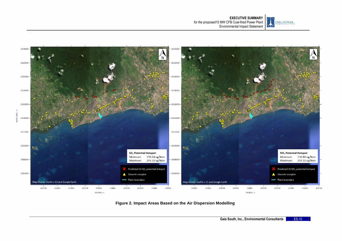
2.7 Delineation of Impact Areas
Post-EIA impact areas were delineated based on the results of the Thermal Plume and Air Dispersion modelling. Figures 2 and 3 show the results of the modelling.
.
EXECUTIVE SUMMARY for the proposed15 MW CFB Coal-fired Power Plant
Environmental Impact Statement
Gaia South, Inc., Environmental Consultants ES-9
Figure 2. Marine Water Impact Map Based on Thermal Plume Modelling
EXECUTIVE SUMMARY for the proposed15 MW CFB Coal-fired Power Plant
Environmental Impact Statement
.
Gaia South, Inc., Environmental Consultants ES-10
Figure 2. Impact Areas Based on the Air Dispersion Modelling

.
EXECUTIVE SUMMARY for the proposed15 MW CFB Coal-fired Power Plant
Environmental Impact Statement
Gaia South, Inc., Environmental Consultants ES-11
3.0 SUMMARY OF BASELINE CHARACTERIZATION
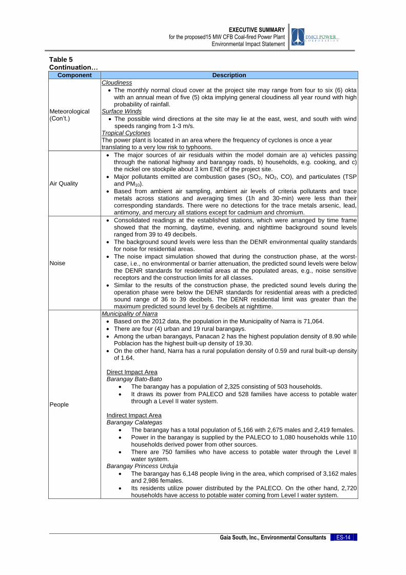
The summary of the baseline assessment is presented in Table 5
Table 5
Summary of profile of the environment and people Component Description
Land Use
Based on the existing CLUP, the municipality has five (5) general land uses: Agriculture Area, Woodland/Forestland, Grassland/Pasture Land, Wetland Area and Miscellaneous Areas where built up area is included.
The Office of the Municipal Agriculturist released a certification stating that the proposed project area is not suitable for agricultural purposes.
The project area is classified as Industrial Area based on the Zoning Certificate released in April 2016.
The proposed project site is located in the allowable zone specifically along Multiple Use Zone based on the Environmental Critical Areas Network (ECAN) Map of Palawan Council for Sustainable Development (PCSD).
Geology
Stratigraphy
The oldest rock unit in central and southern Palawan is the Palawan Ophiolite, an incomplete ophiolitic sequence consisting of ultramafics (Mt. Beaufort Ultramafics), gabbro (Stavely Range Gabbro), pillow basalts and red mudstones (Espina Formation).
Structural Geology
The area is considered as an emerged imbricated thrust belt created by the early Middle Miocene collision between the Cagayan volcanic arc and the drifted Chinese continental margin (Muller 1991).
Geomorphology
The proposed coal-fired power plant lies on the flatland that runs along the coastal areas of southeastern Palawan. The prominent terrain features along the project site are the shore and its associated estuarine flats, and the hills and gently rolling foothills on the northwest. A narrow alluvial fan is located southwest of the project site.
Site Geology
The project site is located on the narrow coastal plain about 5 km east of Calabugas Point in southeastern Palawan. Topography gently rises to the northwest towards the hills and foothills of the Palawan Central Cordillera.
Recent deposits of sand, gravel and soil materials belonging to the Quaternary Alluvium underlie the project site.
The surficial deposits in the project site correspond to the Quaternary Alluvium. Structural Features
No significant geologic structures were observed during the fieldwork in the project site.
Pedology
One soil type (San Manuel sandy clay loam), a Miscellaneous land type (Beach sand, inactive) and mineral ore stockpile/deposit were identified, characterized and mapped in the project area.
San Manuel sandy clay loam developed from the weathering of alluvium that originated from the mountain slopes on the northwestern side of the alluvial plain. Among the heavy metals (arsenic, cadmium, copper, lead, mercury, zinc, and hexavalent chromium) tested in the samples of San Manuel sandy clay loam, only chromium (531.08 and 692.34 mg/kg) is slightly above the contamination level of 400 mg/kg. This can be attributed to the place of origin of the soil, which may have high chromium in its mineralogical composition.
Soil Suitability
The forest tree species (Narra, Molave, Auriculiformis and Mahogany), fruit bearing trees (Tamarind, Coconut, Jackfruit, Kamachile, Mango, Banana, and Guyabano/Atis), Cassava and Peanuts are suitable in all the three (3) soil mapping units (San Manuel sandy clay loam, Beach sand, and nickel ore stockpile) in the project area, with low fertility as the limitation.

EXECUTIVE SUMMARY for the proposed15 MW CFB Coal-fired Power Plant
Environmental Impact Statement
.
Gaia South, Inc., Environmental Consultants ES-12
Table 5 Continuation…
Component Description
Pedology (Con’t.)
Soil Properties
San Manuel sandy clay loam and Beach sand, inactive are with more than 100 cm soil depth and 0-60% clay-silt fraction, it is with “slight susceptibility to erosion”, while the Nickel ore stockpile/deposit is with >100cm depth and 60-100% clay-silt fraction, it is with “moderate susceptibility to erosion”.
The area with Tree plantation is with “slight susceptibility to erosion”. The Grassland and Grassland with isolated stand of Coconut are with “moderate susceptibility to erosion”. The Bare area (nickel ore stockpile/deposit) is with “high susceptibility to erosion”.
The slopes of the three (3) mapping units are 0-3% slopes, which is with “slight susceptibility to erosion”. Except for some mounts in the nickel ore stockpile with >8% slope which is with “moderate susceptibility to erosion”.
Terrestrial Flora
There were 54 species of vascular plants recorded belonging to 34 families in the area. The species richness of the project area constitutes only 1.54% of the estimated flowering plants (approximately 3,000–3,500) found in Palawan (Madulid 2002), with many species that are exotics or non-natives.
In the proposed project area, two (2) plant species (Protium connarifolium and Dillenia luzoniensis) recorded are under the category of Vulnerable (VU) on the Red List of
Threatened Plants of the International Union for Conservation of Nature (IUCN 2015).
At least four (4) species in the proposed project site are endemic to Palawan: Palawan viz., Protium connarifolium, Pandanus reclinatus, Mussaenda grandifolia, and Angelesia palawanensis, but are not necessarily restricted to this particular site or to Brgy. Bato-
bato or to the Municipality of Narra.
Terrestrial Fauna
Forty-three species of birds and six (6) species of mammals were observed and recorded.
Majority of the birds (96%) are listed under the IUCN category Least Concern while Gracula religiosa or Hill Mynah is a threatened species under DENR Administrative Order 2004-15 and is considered as Vulnerable.
For mammals, only the Asian Small-clawed Otter is categorized as Vulnerable while all the other species (except for the Oriental House Rat) are of Least Concern.
Hydrology
The site is confined by one of the five (5) watersheds in the municipality of Narra, Palawan delineated with respect to their proximity to the project site.
It is within the Parian Watershed (WS2), which has a drainage area of 648 has. Headwater of the Parian Watershed comes from mountainous area with slope of 19° to 50° and drains to the Sulu Sea.
The low flows in the Parian river occur during the months of April and May while peak flows occur in November and December.
The most common water source in Brgys. Bato-bato and Calategas is groundwater abstracted by manual pumps. There were also open wells and free flowing springs.
Using PAGASA’s Climate Projections, annual rainfall in 2020 and 2050 will increase by 7.7% (1,784.5 mm) and 2.7% (1,700.4 mm), respectively. October will remain to be the month with most rainfall.
Approximately, the 80.63 m3/day water requirement of the construction would comprise
only about 4% of the watershed’s minimum discharge flow (1,951 m3/day in April). Therefore, water competition is not foreseen.
Result of the flood modelling conducted for the proposed site, indicates that the inundation depths at the areas immediately west, north and east of the project site are predicted to marginally increase due to the diversion of the flow that were otherwise directed to the site if there are no development.
Physical Oceanography
Based from predicted currents in the project area, during amihan and habagat wind conditions, it follows that the tidal conditions dictates the direction of current although wind shear also had a significant influence in steering the currents especially near the coast.
During habagat conditions, the currents exhibit a bias towards the east and northeast,
due to the prevailing south westerly winds.
The high tidal event induces current speeds reaching a maximum of about 0.1 m/s while the currents during tidal ebbing were generally weaker, reaching a maximum of ~6 cm/s near the coast.

EXECUTIVE SUMMARY for the proposed15 MW CFB Coal-fired Power Plant
Environmental Impact Statement
.
Gaia South, Inc., Environmental Consultants ES-13
Table 5 Continuation…
Component Description
Thermal modelling
Result of the thermal plume modeling showed that the mixing zone requirements for temperature (<3°C increase) would be met within a couple of meters from the release site and the area of coverage is minimal under a wide range of depth-averaged flow conditions which is from the composite of the various wind conditions, for the examined design discharge and excess temperature rates.
The intake area where the existing plant draws its cooling water is predicted to increase its temperature by less than 0.50°C. Given this marginal increase in temperature of the raw water which may re-circulate back through the seawater intake, reduction of the thermal efficiency of the pant may be minimal.
Water Quality
Domestic/Groundwater quality
All stations (two community water sources and two privately owned pumps) were found unfit for drinking with respect to microbial quality.
Freshwater quality
All stations (Calategas, Parian and Balitien rivers) showed values were within their prescribed water quality classification, except for total coliform.
Marine water quality
Result of the analysis of five (5) marine water samples shows all the parameters measured were way below the detection limits of the analytical methods used, indicating good quality for the Class SC standard.
Freshwater Ecology
Four sampling stations (Upstream (FW1) and Downstream (FW2) Parian and Upstream (FW3) and Downstream (FW4) Balitien) were established.
Upstream stations of Parian and Balitien have a total of 153 and 55 cells per liter of water dominated by Merismopedia. The downstream stations on the other hand are dominated by diatoms.
Parian river downstream has the highest concentration of phytoplankton at 766 cells per liter but dominated by the diatoms.
The absence of insect benthos is quite notable from FW1 (upstream Parian) and FW3 (upstream Balitien).
Downstream stations (Parian and Balitien) did not yield any benthic organisms.
Marine ecology
Four marine sampling sites were established: MW1- 900 m west of pier, MW2 - 0.8 km west of pier; a “control” site, MW3-638 meters southeast of pier and MW4-671 m east of pier.
All sampling sites have phytoplankton density not exceeding 500 cells per liter of water.
Coral cover from MW1 may be considered poor with only 8.46% of the total benthic cover as live coral while MW2 (Marine Protected Area) has a relatively better coral cover at 9.32% dominated by branching colonies, specifically Poccillopora.
Coral diversity is lowest at MW3 with only four (4) genera documented.
There are 18 fish species documented from MW1, 46 species from MW2, and 12 species from MW3. Computed fish density also followed the trend in the number of species with MW2 having the highest density of fish at 11 individual/km
2.
Based on the heavy metal analysis of the fish gut and meat samples, generally, planktivore showed lower levels of heavy metal either on the gut or on the meat than carnivore.
Meteorological
Climate
The DPC power plant site falls in an area where seasons are not very pronounced; relatively dry either from December to February or from March to May and wet during rest of the year.
Rainfall
The site may experience an annual rainfall of 1514.1 mm with the maximum and minimum occurring in October and February respectively with 142 days of rain in a year.
Temperature
The site may experience temperatures of 22.7°C in January to a maximum of 32.7°C in April with a seasonal temperature difference of about 10 degrees.
Relative Humidity
The monthly relative humidity at the site may range from 78% to 86% with July and October as the most humid months.
EXECUTIVE SUMMARY for the proposed15 MW CFB Coal-fired Power Plant
Environmental Impact Statement
.
Gaia South, Inc., Environmental Consultants ES-14
Table 5 Continuation…
Component Description
Meteorological (Con’t.)
Cloudiness
The monthly normal cloud cover at the project site may range from four to six (6) okta with an annual mean of five (5) okta implying general cloudiness all year round with high probability of rainfall.
Surface Winds
The possible wind directions at the site may lie at the east, west, and south with wind speeds ranging from 1-3 m/s.
Tropical Cyclones The power plant is located in an area where the frequency of cyclones is once a year translating to a very low risk to typhoons.
Air Quality
The major sources of air residuals within the model domain are a) vehicles passing through the national highway and barangay roads, b) households, e.g. cooking, and c) the nickel ore stockpile about 3 km ENE of the project site.
Major pollutants emitted are combustion gases (SO2, NO2, CO), and particulates (TSP and PM10).
Based from ambient air sampling, ambient air levels of criteria pollutants and trace metals across stations and averaging times (1h and 30-min) were less than their corresponding standards. There were no detections for the trace metals arsenic, lead, antimony, and mercury all stations except for cadmium and chromium.
Noise
Consolidated readings at the established stations, which were arranged by time frame showed that the morning, daytime, evening, and nighttime background sound levels ranged from 39 to 49 decibels.
The background sound levels were less than the DENR environmental quality standards for noise for residential areas.
The noise impact simulation showed that during the construction phase, at the worst-case, i.e., no environmental or barrier attenuation, the predicted sound levels were below the DENR standards for residential areas at the populated areas, e.g., noise sensitive receptors and the construction limits for all classes.
Similar to the results of the construction phase, the predicted sound levels during the operation phase were below the DENR standards for residential areas with a predicted sound range of 36 to 39 decibels. The DENR residential limit was greater than the maximum predicted sound level by 6 decibels at nighttime.
People
Municipality of Narra
Based on the 2012 data, the population in the Municipality of Narra is 71,064.
There are four (4) urban and 19 rural barangays.
Among the urban barangays, Panacan 2 has the highest population density of 8.90 while Poblacion has the highest built-up density of 19.30.
On the other hand, Narra has a rural population density of 0.59 and rural built-up density of 1.64.
Direct Impact Area Barangay Bato-Bato
The barangay has a population of 2,325 consisting of 503 households.
It draws its power from PALECO and 528 families have access to potable water through a Level II water system.
Indirect Impact Area Barangay Calategas
The barangay has a total population of 5,166 with 2,675 males and 2,419 females.
Power in the barangay is supplied by the PALECO to 1,080 households while 110 households derived power from other sources.
There are 750 families who have access to potable water through the Level II water system.
Barangay Princess Urduja
The barangay has 6,148 people living in the area, which comprised of 3,162 males and 2,986 females.
Its residents utilize power distributed by the PALECO. On the other hand, 2,720 households have access to potable water coming from Level I water system.

EXECUTIVE SUMMARY for the proposed15 MW CFB Coal-fired Power Plant
Environmental Impact Statement
.
Gaia South, Inc., Environmental Consultants ES-15
Table 5 Continuation…
Component Description
People (Con’t.)
Barangay Princess Urduja
The barangay has a population size of 1511 with 748 males and 763 females in 2014.
Three hundred seventy-seven families obtain their electrical power from PALECO and the same number of families derives their potable water from Level II water system. On the other hand, 15 families source their water from Level I water system.
Perception towards the project
Ninety-six percent of the respondents from Brgy. Bato-bato thought that there will be positive impacts as a result of the proposed project while only 3.27% saw otherwise. Perceived beneficial effects of the project for all the respondents include provision of employment (23.73%), increase in revenue of the barangay and municipality (17.03%), increase in land values (15.56%), increase in business opportunities (15.25%), industrialization and development of the community (12.40%), and more community projects and assistance coming from the proponent (10.25%).
Forty-seven percent of the respondents agreed that there will be negative effects from the proposed project which include pollution/ sickness/ poisoning of the environment aside from the possibility of bringing in more migrants into the community.
Seventy-two percent of the respondents believed that the proponent will provide assistance to the local residents and community as well. On the other hand, 13.24% thought that the proponent would be able to help but not much.
Public Health
Municipality of Narra
The health services in the municipality of Narra are being provided by five (5) medical and health facilities. Two are government owned while the other three (3) are owned by private individuals. Moreover, all 23 barangays have functional barangay health stations.
Waste segregation is being implemented in Narra. Direct Impact Area Barangay Bato-Bato
The leading causes of diseases are common coughs and colds classified as pneumonia, hypertension, malnutrition, gastritis, renal and urinary tract infections, myalgia, pulmonary tuberculosis and allergic rhinitis.
The common leading causes of mortality from 2011 to 2014 are pneumonia, chronic renal failure, and cerebrovascular accident, and congestive heart failure.
In 2014, there were medical professionals available to take care of the residents of Brgy. Bato-bato. There was a doctor, dentist, nurse, midwife, and sanitary inspector in the community. There is one (1) BHW for every 220 residents in the barangay.
Indirect Impact Area Barangay Calategas
The leading causes of diseases varies between the years 2013 and 2014 with upper respiratory tract infection (URTI) being the leading cause of diseases in 2013 while having no recorded case in 2014.
The leading causes of deaths varied for the years 2013 and 2014 with pneumonia being the leading cause of mortality in 2013 and aspiration pneumonia in 2014.
In 2014, a nurse and a midwife take care of the 4,707 population of Brgy. Calategas Narra, Palawan. There is one (1) midwife and one (1) nurse for every 4,707 resident in the barangay and one (1) Barangay health worker for every 314 resident in the barangay.
4.0 SUMMARY OF ALTERNATIVES
Various options were considered for the power plant project. For this proposed project, DPC
realized that third generation coal-fired power plant is the optimal solution consistent with the
DOE’s program to shift away from imported oil to which coal is generally lower and stable in
terms of price.

EXECUTIVE SUMMARY for the proposed15 MW CFB Coal-fired Power Plant
Environmental Impact Statement
.
Gaia South, Inc., Environmental Consultants ES-16
The site selected for the proposed power plant is a former ore stockyard of the Narra Nickel
Mining and Development Corporation (NNMDC). Based on the Environmental Critical Area
Network (ECAN) Map of Narra, the proposed area is under the Multiple Use Zone
classification. Furthermore, the site already has an existing causeway, which makes it
accessible both thru land and water transport. In the previous plans of DPC, areas
considered were Brgy. Panacan in the Municipality of Narra and Municipality of Aborlan.
However, due to some social concerns, these areas were not selected.
The power plant shall utilize the Circulating Fluidized Bed (CFB) technology over the
Pulverized Coal (PC) technology, which has an older machinery. The CFB technology offers
lower emissions and is efficient for power generation lower than 300 MW.
The Semirara coal is the sole fuel that has been considered by DPC. With respect to the
agreement between the Sangguniang Bayan of Narra and DPC, the power plant was
redesigned as dual fed (80% + 20% biomass), whenever biomass is available from local
suppliers in Narra. The biomass fed is bamboo to be cultivated as livelihood program of the
local government. The complete evaluation of project alternatives is presented in Table
1.3.1 in Chapter 1.
5.0 SUMMARY OF IMPACTS AND MITIGATION
The probable impacts of the proposed project and implementation of the mitigating
measures are summarized in the following discussions.
The Land
There will be no change in the landform due to the areas current flat topography. Since the
proposed site is situated within a Multiple Use Zone based on the Environmentally Critical
Areas Network (ECAN) Map of Palawan and classified as an Industrial Zone according to
the land use of the municipality, there will be no issue on its consistency in terms of land
classification and/or land use.
Erosion in the coastal area as it is currently evident in the project site may be addressed
through monitoring and proper designing of power plant structures and establishing
preventive mechanisms such as vegetation cover and retaining walls.
Vegetation removal during the construction period may lead to habitat disturbance.
Therefore, biodiversity conservation may be prioritized by conserving important plant species
that are endemic to Palawan through proper transplanting, if highly necessary. A Biodiversity
Conservation Program shall also be developed by the company, and/or participate in the
National Greening Program.
The Water
Inundation depths at some areas in the project site may potentially increase and directed
towards the project site. By deepening the channel which will increase the drainage capacity
and observing the regulations in the Water Code of the Philippines (e.g. buffer zone), DPC
can maintain a flood free area. Moreover, sound plant construction and establishment of
containment structures at strategic locations will prevent silt deposition.
EXECUTIVE SUMMARY for the proposed15 MW CFB Coal-fired Power Plant
Environmental Impact Statement
.
Gaia South, Inc., Environmental Consultants ES-17
To be able to address the potential increase in water ambient temperature, optimization of
the design of the outfall must be considered by DPC. During the operation, release of water
during mid-day shall be minimized and maximized during the evening. Design of the outfalls
shall ensure that efficient mixing is achieved to limit the plant’s thermal effluent to 3°C rise in
temperature at the outfall mouth.
Proper storage of coal ash in an ash pond and shipment of coal ash to Semirara are among
the options to alleviate potential degradation of water quality on site. Moreover, installation
of oil-water separator and proper storage of fuel oil and lubricants allow containment of
potential contaminants. Construction of silt traps and diversion canals will allow settling of
sediments.
Marine life conservation is coupled with appropriate and effective reef enhancement program
in which DPC may develop. Released water from the outfall must strictly follow the DENR
standards for thermal effluent (DAO 1990-35) to locally mitigate higher sea surface
temperature that may result to swarming.
The Air
Air pollution from the boiler stack and standby generators, vehicle and carbon dioxide
emissions are among the potential impacts of the power plant which may be addressed by
various measures such as installation of Continuous Emission Monitoring System (CEMS),
electrostatic precipitator, proper operation and maintenance of generator set engines,
emission testing of operation vehicles, and development of sustainable greening program.
One important procedure in attenuating propagated noise is the construction of noise
barriers such as berms, walls and fences, and nurturing of dense vegetation within and
around the power plant complex. Noise at source requires regular maintenance of
equipment and parts and operation of noisy machines only at designated schedule.
The People
Increase in population is expected upon commencement of the power plant due to various
employment and business opportunities in the host community. Therefore, constant
monitoring of population and migration rate has to be conducted in coordination with the
LGU.
An intensified implementation of community programs through ER 1-94 is a reliable measure
of local progress. Constant communication with the stakeholders through IEC activities is a
good practice in understanding the needs of the locality towards lifestyle and economic
improvement. DPC must develop a harmonious relationship with the LGU and stakeholders
in order to promote strong collaboration in addressing local progress, security and
opportunities. Moreover, public health is deemed as one of the major concerns in setting up
a coal-fired power plant. Hence, it will be beneficial to both DPC and host communities if a
regular conduct of Health Impact Assessment (HIA) will be implemented to monitor the
health condition of the residents and immediately address health-related issues that may be
attributed to the operation of the power plant.