Embed Size (px)
Citation preview

International Journal of Technology (2013) 3: 269‐279 ISSN 2086‐9614 © IJTech 2013
FROM BRICKS TO BYTES: DIGITIZING GREEN CITIES
Diane Valerie Wildsmith1*, Phil Smith 2
1Department of Architecture, Faculty of Engineering, Universitas Indonesia, Kampus Baru UI Depok 16424, Indonesia
2Visiting Scholar VEPR, Vietnam National University, Hanoi
(Received: February 2013 / Revised: June 2013 / Accepted: July 2013) ABSTRACT The research is focused on green cities and the role of digital media in the development of corporate sponsorship for high tech green cities currently under construction (e.g., Masdar in Abu Dhabi, Songdo in South Korea, PlanIT Valley in Portugal). The urban imaginary of virtual green cities is linked to an ecological cyberspace that promotes futuristic images of green cities, such as Vincent Callebaut’s Hydrogenase (2010)—a transport hub for an algae farm and biohydrogen airships. These images of sustainable green cities pose a challenge to defining ecological civic space and green architecture, especially in the transformation of Jakarta into an eco-architectural hub that balances social, economic, and environmental issues. The role of Google Earth and digital maps must not be underestimated in digitizing the “bytes” and realizing design scenarios for the “bricks” of green cities, including those options related to traffic planning simulations, water catchment scenarios, disaster/flood planning, and social media simulation for crowd control and governance issues. Keywords: Civic space; Glocal; Green architecture
1. INTRODUCTION Social media have focused on the Hotel Indonesia Roundabout (Bundaran HI) as an urban acupressure point for the promotion of civic space. Worldwide, social media have promoted spontaneous flash mob dancing inspired by the South Korean singer PSY with his Gangnam style that resembles both the Elvis Presley and Michael Jackson crazes; he has inspired public street galloping and dancing in a glocal celebration of globalization and localization in civic spaces from New York City to Jakarta. Besides being a media hub for cultural expression (Gangnam Style Flash Mob 9, 2012), the Hotel Indonesia Roundabout is also a contested political territory in which various celebrations have taken place to recognize the emergent nation-state of Indonesia and the Welcome Statue (Tugu Selamat Datang, 1961). The statue was built during the Sukarno era as a national monument and a landmark to herald the ASEAN Games IV (Kurniawan, 2013). The Welcome Statue at the Hotel Indonesia Roundabout was modernized in 2002 with a fountain as a way to reclaim security and police control over what had become a contested site for various political and social demonstrations during the emergence of democracy after the handover of the Suharto government.
As a civic proponent for the vitality of the democratic process, Joko Widodo (Jokowi) led a successful election campaign to become Governor of DKI Jakarta (October 2012); his mass of supporters wore checkered shirts. * Corresponding author’s email: [email protected], Tel. +62‐21‐7863512, Fax. +62‐21‐7863514

270 From Bricks to Bytes: Digitizing Green Cities
Yet, the central business district of Jakarta, a global megacity that is admired nationally and internationally, is not immune to the effects of climate change, flooding, and natural disasters, as witnessed by the January floods in 2013 that inundated the Hotel Indonesia Roundabout and shut down the main corporate and commercial boulevards of Thamrin and Jalan Sudirman.
Recent plans for the new Mass Rapid Transit (MRT) suggest that the positive civic space will become instead an urban void leading to the new underground mass rapid station and commercial mall, further underscoring the need for additional green space in the urban streetscape. In its most recent permutation, the civic space at the Hotel Indonesia Roundabout will be celebrated as part of a modern mass transit hub connecting Jakarta with the suburbs of the megacity in South Jakarta, thus expanding the access for social media penetration and mass gatherings. It is uncertain if the realities of mass transport planning will be able to accommodate the infrastructure required for the MRT, possible relocation of the main traffic arterials, additional drainage infrastructure, plus an allowance for an expansion of 30% open space and the provision of civic space to allow for festivities, street markets, and New Year’s celebrations. These issues remain as challenges for Jakarta’s architects, planners, politicians, and citizens. One example of how bytes (information technology) can improve the physical structure (the bricks) of a city is the Boston Transport system (2010) that used real time data simulation to synchronize its bus lanes. It is anticipated that the necessity of using bricks as well as bytes to solve Jakarta’s transport infrastructure and civic space will converge at the Hotel Indonesia Roundabout as Jakarta becomes one of the megacity hubs for ecological green architecture.
This paper follows a tripartite sequence. First, the imaginary of green cities and the metaphors of bricks and bytes are analyzed in the context of three case studies of high tech green cities currently under construction, namely Masdar in Abu Dhabi, Songdo in South Korea, and PlanIT in Portugal. Second, the role of the social media in relation to local and global phenomena is considered relative to the balance between eco-social and eco-technological issues in urban planning and green architecture, specifically at the Hotel Indonesia Roundabout as a contested civic place in central Jakarta. Third, in comparing the virtual reality of green cities with the actual realities of civic space, traffic congestion, and climate change, the Hotel Indonesia Roundabout and plans for the MRT are analyzed in the context of realizing a mandatory increase in open space of 30%, providing civic space, and implementing MRT. In conclusion, a visionary design competition entitled “Architecture Triennale 2012: Architects for People—Towards Jakarta 2045,” sponsored by the Indonesian Institute of Architects (IAI), shortlisted “Jakarta Xcavated” in the professional category. The design allows for the addition of green parks above the city and underground commercial and transport facilities below the city as one alternative associated with the connection between bricks and bytes. 2. REALIZING THE IMAGINARY OF VIRTUAL GREEN CITIES Generally speaking, computer-generated virtual realities are based on bytes, units of digital information in computing and telecommunications composed of 8 bits, a term coined by Werner Buchholz (a German computer scientist) in 1956 for the design of the IBM 701 Defense Calculator—introduced in 1952 as IBM’s first commercial scientific computer—and IBM’s 7030 Stretch computer (Wikipedia, 2013). A byte is used to encode a singular character of text, and in that sense, it is comparable to a brick in tectonic architecture as the major component of a wall. The catch phrase “bricks and mortar” is a metonym, a figure of speech associated with two concepts related to traditional building materials. In banking terms, bricks and mortar are related to investments in buildings as securities. In e-commerce, they are related to a business with a physical presence and face-to-face communications, as opposed to online retailers that communicate electronically, such as Amazon. The computer language metaphors overlap

Wildsmith & Smith 271
between computer architecture and building architecture, resulting in virtual realities.
Social media web sites like YouTube and specific websites promoting green cities promulgate the idea of virtual green cities. Hydrogenase, by Vincent Callebaut (2010), shown in Figure 1, is a virtual reality project based on hydrogen-powered airships. This fantastic idea literally fuels the imagination and provides the precedent for green cities based on alternative energy from algae farms coupled with high technology. To paraphrase M. Christine Boyer (1996), what the machine was to modernism, the computer was to postmodernism; and what the social media is to hypermodernism, what the YouTube is to spontaneous hyperconnectivity. The computer information age involved Boolean logic, a series of logics denoted as true or false, and a series of binary syntaxes as 0 or 1, to organize data into domains of artificial intelligence and cyberspace. Metaspace or hyperspace often imposes a bird’s eye view—a level of reality that allows for a collective imaginary about cybercities and combines globalization and localization into a glocal experience. Boyer (1996) explains:
This unwieldy mixture of urban dystopia and cyberspace—here called CyberCities—turns the reality of time and place into an imaginary matrix of computer nets electronically linking together distant places around the globe and communicating multilinearly and non-sequentially with vast assemblages of information stored as electronic codes.
Figure 1 Vincent Callebaut, Hydrogenase (2010); permission pending, http://www.inhabit.com
With their philosophical and intellectual roots in cybercities, technological variants of green cities like Masdar in Abu Dhabi, Songdo in South Korea, and PlanIT in Portugal rely on technological sponsorship, linkages with computer companies, and advanced technology to create sustainable ecocities. Indeed, such a city is managed and controlled by sophisticated computer programs that consume terabytes of data and provide smart grids, smart traffic and transport, and smart waste and water management. Clearly, reducing our consumption of resources is as much about management as it is about technology. The sponsors are keen to promote connected smart communities and their particular management strategies for achieving them, as smart cities are seen as the drivers of the next technological revolution underpinning future revenue streams. Cyberspace focuses more on technology to realize utopian visions.
Masdar, as a global hub for emergent technologies, is a sustainable city under construction (Figure 2). It is scheduled for completion in 2025. Designed by Foster + Partners, Mott MacDonald, and Sheppard Robson International, Masdar is estimated to cost US$18–19 billion

272 From Bricks to Bytes: Digitizing Green Cities
for 40,000 residents and 50,000 commuters on a 6 km2 site. Masdar has been designed as a pedestrian city with a modular transportation system of Personal Rapid Transport (PRT) and Freight Rapid Transport (FRT), as well as electric cars. Technology and development partners include Siemens, Mitsubishi Heavy Industries, GE, Schneider Electric, BASF, and Bayer MaterialScience.
Figure 2 Masdar City master plan, according to Foster + Partners (2007); permission pending,
http://www.bustler.net
Designed by Kohn Pedersen Fox Associates, the Songdo International Business District (IBD) at Incheon in South Korea is under construction with a completion date of 2016. Development is underway for 65,000 residents and 300,000 commuters at a construction cost of US$35 billion on a 1,500 acre (6.07 km2) site (Figure 3).
Figure 3 Songdo master plan, Kohn Pedersen Fox Associates (2009); permission pending,
http://www.archleague.org
The buildings are expected to receive LEED ratings, and there will be 40% green space in the city with sustainability designed into the master plan. In partnership with Cisco, the city includes state-of-the-art communications, broadband connectivity, and smart meters in each home to monitor electricity and water consumption. This model of an instant city is applicable to meet urban infrastructure needs, and it has a potential market beyond Songdo. Johnson (2010) observed, “According to a study by an investment bank, CIBC World Markets,

Wildsmith & Smith 273
governments are expected to spend US$35 trillion on public works projects in the next 20 years”. In terms of the “City of the Future,” Cisco cites estimates by ABI Research that $39.5 billion will be spent on smart city technologies in 2016 (ABI Research, 2013). These technologies include smart transportation pricing, Internet connectivity to all homes and schools, demand alert response for energy consumption, medical facilities, and patient coordination, as well as electronic offices.
PlanIT is a model city and sustainable community that is being developed by the Municipality of Paredes near Porto in Northern Portugal for a population of 225,000 on a 1,700 hectare (17 km2 or 4,000 acre) site for €10 billion (US$14.1 billion). Its targeted completion date is 2015 (Figures 4 and 5). The co-founder, Steve Lewis of PlanIT in Portugal, was formerly the General Manager of Market Development at Microsoft. According to Quintain, a London-based property developer, they are joining “...Microsoft, Buro Happold, Cisco, and Formula One [supplier to McLaren] as partners in the Living PlanIT concept to develop a ‘smart’ city, where built-in sensors measure occupancy, temperature, humidity and energy production and use.” The intention to incorporate technology and computer systems is apparent in the “Introduction to Future City Technology” as follows:
Living PlanIT‘s Urban Operating System (UOS™) provides essential middleware—built on Cisco infrastructure and Microsoft Cloud platforms—that enables networked sensors and actuators to be deployed at scale, coordinated through a unified and secure real-time control layer which also shares and collects data across the entire urban landscape.
Based on an Urban Operating System (UOS) and PlaceApps, urban data and monitoring systems form the core of intellectual property. Construction is to be based on mass production principles of automotive and aircraft manufacturing. Besides portraying an image of a digital green city, PlanIT Valley will involve partnerships with Portugal’s national government, universities, and companies in a living technology laboratory.
Figures 4 and 5 PlanIT, Portugal, Buro Happold, Engineers (2010); permission pending, http://jornal.publico.pt/noticia/06-03-2011/planit-valley-quer-ser-a-montra-do-urbanismo-sustentavel-21474643.html and
http://cdn.controlinveste.pt/storage/ng1153995.jpg?type=big&pos=0
Each of these green city developments shares a strong economic vision and an integration with the wider global economy (globally interconnected through bytes). Masdar is branded as a global center of excellence for renewable and clean technologies; developers have already recruited the International Renewable Energy Association and Siemens to its hub. However, Masdar has modified its targets as a zero-carbon city. Coordinators of Songdo International Business District are Gale International, United Technologies Corporation, and the Hanjin Group; their collective aim is to attract multi-national companies who will make it their

274 From Bricks to Bytes: Digitizing Green Cities
regional office for Northeast Asia. PlanIT is marketing itself as a base for companies developing products and services for other cities seeking to develop their green credentials. Neither Masdar nor PlanIT has given serious consideration as to why environmental companies would want to move to either the UAE or to Portugal, save the important agglomeration effects popularized by Richard Florida in his Ideopolis thesis, which are dependent on a significant mass being achieved (Alusi et al., 2011).
Despite the aim for green cities to be replicable and replicated, it is likely that only the property-driven Songdo economic model (more bricks than bytes) could be replicated by other aspiring and strategically placed green cities, as Songdo is between major economic powerhouses (i.e., Beijing and Tokyo). The connectivity of their communities seems to suggest cultivation of an Ideopolis-inspired creative class at the forefront of the knowledge economy (more bytes than bricks). Nevertheless, even those cities that could claim the title of knowledge cities have done so in response to global economic forces, more so than through the sort of planning and control that is being integrated within these green cities (Yigitcanlar et al., 2008). Indeed, the failure to attract high technology tenants to Serpong’s Science Park serves as a warning of what happens when well-intentioned plans fail to coincide with global market forces.
Digitized images of cybercities and YouTube broadcasts have formed the basis for the imaginary of these green cities and the development of corporate sponsorship of high tech green cities currently under construction. Their technological solutions are far more than the “green wash” that Jakarta’s newer commercial developments have cloaked themselves with, although the application of these technologies outside of these “experimental” cities may prove little more than a tool for managing our increasing consumption of scarcer resources (crowding even more cars into Jakarta’s already crowded streets). 3. SOCIAL MEDIA: CHALLENGING THE REALITY OF CIVIC SPACE The impact of technology on urban development and the allocation of civic space are related to the provision of data from geographic information systems (GIS). In 1972, NASA dedicated its landsat satellite to mapping natural and cultural resources on land and ocean surfaces for classifying land use, monitoring urban growth, and acting as an aid in regional planning for mapping and transportation networking. The information was and is being used to facilitate transport and power transmission routes. The satellite data analysis is able to predict various urban growth scenarios so that planners can evaluate the spread of urban growth in the context of megacities and their imposition on peri-urban areas associated with forestry and agricultural Landsat (Salkin, 2008).
This grouping together of databases and cartography, along with the increased power and usability of computers, has led to storage of large amounts of data as visual representations; furthermore, access to websites such as Google and Google Earth is available. With access to visual mapping, the land use review process has been streamlined, facilitating the production of accurate maps and three-dimensional views of the city, and further materializing the city in a virtual way through the Internet and social media access. The ability to manage transportation, water, and sewage infrastructure has been enhanced, as well as the ability to calculate green space areas. Salkin (2011) reports that GIS—a web-based interactive tool—is used by local governments to determine the proposed locations of parks.
Besides providing mapping data with access to Google Earth, Internet websites such as Facebook and YouTube provide a platform for organizing and communicating with individuals and socio-political groups to arrange for events and demonstrations, thus underscoring the importance of social media and its impact on civic space. A new phenomenon, related more to

Wildsmith & Smith 275
entertainment than politics (although in Southeast Asia’s case it is sometimes difficult to accurately differentiate), is the glocal sensation of South Korean Gangnam style dancing. However, the occupation of public space by illegal flash mobs requires involvement by the state and security officers to safeguard the city and control crowds, specifically at the Hotel Indonesia Roundabout in Jakarta (Figure 6).
Figure 6 The welcome statue at hotel
Indonesia roundabout; permission pending, http://www.eazytraveler.com/2011/08/jakarta-jaunt.html
According to Lai Chee Kien at the First Conference on Civic Space in 2010 (Universitas Indonesia and the University of British Columbia), “At the monument at the Hotel Indonesia, demonstrations take over the state space. The people who want to have a say in the civic culture will want to occupy that place. The police also occupy the same space. We have to look at galactic poles with centrally contained power.” This analysis illustrates that space is contested socially and shaped by social interaction and power relations. A relevant example is the WWF-sponsored Panda and Car-Free Day in 2012 (Figure 7).
Figure 7 Flash mob at the Hotel Indonesia Roundabout during a WWF sponsored Panda and car-free
day, illustrating the contested space between City of Jakarta and the public (2012); permission pending, http://www.hersmagz.com/spotlight/2012/12/flashmob-panda-di-car-free-day-wwf-indonesia-2

276 From Bricks to Bytes: Digitizing Green Cities
Gangnam style dancing, songs by South Korean rapper PSY, and an illegal flash mob advertised through the social media by the Happy Holiday Indonesia team (a group of video artists inspired by JackAss and Running Man, Korea), resulted in 1,000 people converging at the Hotel Indonesia Roundabout on September 9, 2012—ostensibly to jump in the fountain. Afterwards, a four-minute video broadcast on YouTube generated 336,000 views and 1.4 million comments from Indonesian netizens after it was posted on September 13 (Figure 8). More recently, these video artists organized a Harlem Shake (another glocal phenomenon) on one of Jakarta’s rapid transport buses, TransJakarta Busway (BRT), a precursor to the MRT.
Figure 8 Flash mob and South Korean Gangnam dancing, Hotel Indonesia Roundabout, 2012; permission pending, http://indoboom.com
4. HOTEL INDONESIA ROUNDABOUT: FACING THE REALITY OF GREEN CITIES Tambun (2012) noted, “Under a 2007 national law, the city is supposed to dedicate at least 30 percent of its total land area to open green space, but Jakarta has never been able to meet the requirement because of complications in freeing up occupied land and past administrations’ preference for developing open areas into commercial and retail zones rather than parks.” Initially, Jakarta‘s DKI Governor has targeted an increase in green space from current levels of 9.8% to 20%. The facts, however, indicate that this requirement would reduce the number of traffic lanes, yet no radical departure from the use of cars and trucks around the Hotel Indonesia Roundabout or an extreme number of road closures is projected (Figure 9). Additionally, the MRT void would present problems during the monsoon season and during flooding occurrences because of the failure of the canal infrastructure, as experienced in January 2013. There is a concern regarding the potential impact of climate change and urban development on urban water catchment areas, especially around Jakarta’s iconic shopping malls, the current substitute for civic space (Figure 10).
Even if the fountain was classified as “blue-green” open space, the MRT proposal for a void open to the mass transit station, underground shopping concourse, and mall would produce a negative space, rather than a civic space at ground level (Figure 11). The potential for use of the urban space for civic events, including festivities, giant digital TV screens, and peaceful political protests would be reduced significantly with the proposed expansion of green space and the MRT void. In fact, glass paving blocks could meet the requirements for the fountain, and a skylight atrium may fulfill its symbolic use as public space to be enjoyed by all Jakartans and visitors as a new symbol for an eco-architectural transit hub at the Hotel Indonesia Roundabout.
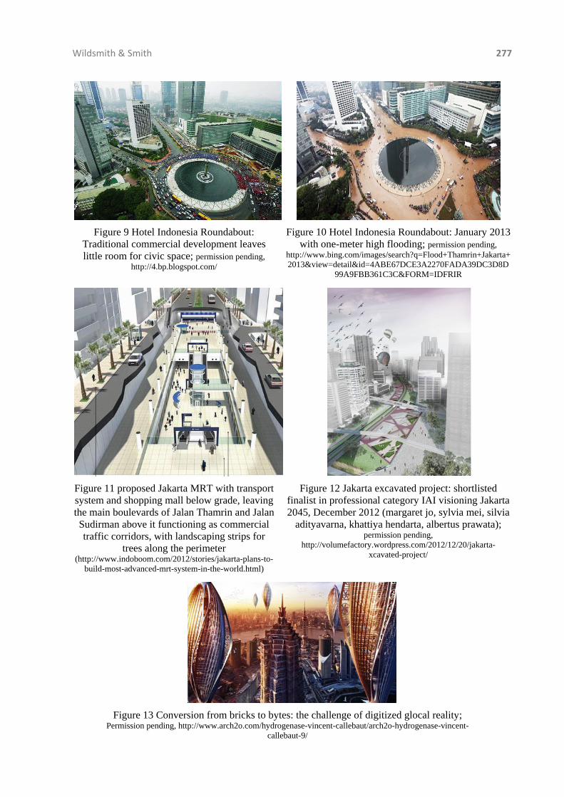
Wildsmith & Smith 277
Figure 9 Hotel Indonesia Roundabout: Traditional commercial development leaves little room for civic space; permission pending,
http://4.bp.blogspot.com/
Figure 10 Hotel Indonesia Roundabout: January 2013 with one-meter high flooding; permission pending,
http://www.bing.com/images/search?q=Flood+Thamrin+Jakarta+2013&view=detail&id=4ABE67DCE3A2270FADA39DC3D8D
99A9FBB361C3C&FORM=IDFRIR
Figure 11 proposed Jakarta MRT with transport system and shopping mall below grade, leaving the main boulevards of Jalan Thamrin and Jalan Sudirman above it functioning as commercial traffic corridors, with landscaping strips for
trees along the perimeter (http://www.indoboom.com/2012/stories/jakarta-plans-to-
build-most-advanced-mrt-system-in-the-world.html)
Figure 12 Jakarta excavated project: shortlisted finalist in professional category IAI visioning Jakarta 2045, December 2012 (margaret jo, sylvia mei, silvia
adityavarna, khattiya hendarta, albertus prawata); permission pending,
http://volumefactory.wordpress.com/2012/12/20/jakarta-xcavated-project/
Figure 13 Conversion from bricks to bytes: the challenge of digitized glocal reality;
Permission pending, http://www.arch2o.com/hydrogenase-vincent-callebaut/arch2o-hydrogenase-vincent-callebaut-9/

278 From Bricks to Bytes: Digitizing Green Cities
5. CONCLUSION To a large extent, Jakarta epitomizes the challenges that most cities will face in attempting to develop their green credentials. The conceptual framework provided by Jabareen (2008) highlights the enormous issues confronting the new mayor and his administration. These include the ethical paradox of balancing sustainability with economic development, limitations for greening and eco-repairing this high-density city (as an extension of its natural capital), and the need for greater equity (political and economic) following a period of spectacularly uneven development. Additionally, there are needs for green architectural forms suited to Jakarta’s climate (incorporating passive solar design) and integration with city management (e.g., smart grids, transportation, and traffic). Governor Jokowi’s ideals of utopianism and global urban political leadership only serve to highlight the inappropriateness for Jakarta to borrow from distant examples, thus inspiring Jakartans to devise a unique solution for their tropical megacity. Despite the challenges of new green architectural forms (bricks) and integration of city management (bytes), the goals can be met. Borrowing from David Satterthwaite’s (1997) definition of a healthy city as one which provides a healthy living and work environment, safe water, sanitation, refuge collection and disposal, drains and paved roads, we immediately understand what needs to be prioritized, but the reality of converting bytes to bricks remains the challenge of our times.
Although the aspirations for green cities are based on the balance between green space and civic space, the realities of the built-up metropolitan infrastructure require the imbrications of the materiality of the city with its digital management of human, spatial, and natural resources. The IAI Architecture Triennale 2012: Architects for People—Towards Jakarta 2045 design competition generated proposals for various alternatives, including canals and parks in Jakarta’s main thoroughfares and squares to accept the seasonal inundation caused by flooding and to provide parks and open space with underground facilities (Figure 12). Besides the vertical expansion of high-rise buildings, the potential for green roofs and green architecture with urban agriculture inspires the convergence of the virtual realities, with the future reality of green architecture as a glocal response in Jakarta or Shanghai (Figure 13). Additionally, the multiple layers of eco-social, economic, political, and social media priorities must be acknowledged. 6. REFERENCES Alusi, A., Eccles, R., Edmondson. A., Zuzul, T., 2011. Sustainable Cities: Oxymoron or the
Shape of the Future, Harvard Business School, Working Paper. Boyer, M.C., 1996. Cybercities, New York: Princeton Architectural Press, p. 14. Callebaut, V., 2010. Hydrogenase Algae Farm to Recycle CO2 for Biohydrogen Airships,
Shanghai, 2010. Available at: http://vincent.callebaut.org/page1-img-hydrogenase.html Cities in the Cloud: A Living PlanIT Introduction to Future City Technologies, 2011. White
paper pdf edition, p. 3. Available at: http://living-planit.com/planit Citronot, L., 2013. Jakarta Hit Again by Flooding. Accessed February 7, 2013. Available at:
http://www.bing.com/images/search?q=Flood+Thamrin+Jakarta+2013&view=detail&id=4ABE67DCE3A2270FADA39DC3D8D99A9FBB361C3C&FORM=IDFRIR
Gangnam Style Flash Mob, an Illegal Mob Happy Holiday Indonesia. Accessed September 9, 2012. Available at: http://www.youtube.com/watch?v=lh1edaOa514
Institute for Transportation and Development Policy (ITDP), 2007. Making TransJakarta Busway a world class BRT system. Available at: http://www.itdp.org/documents/Presentation_to_Gov_6Nov07.pdf; and Implementing Low Carbon Public Transport in Jakarta Project, March 2012, downloaded from http://www.itdp-indonesia.org/images/stories/Publication/Report/reeep%202%20-%20optimized%20transjakarta%20network.pdf

Wildsmith & Smith 279
Jabareen, Y., 2008. A New Conceptual Framework for Sustainable Development. Environment, Development and Sustainability, Volume 10, pp. 179-192.
Kien, L.C., 2010. States and States: Colonial and National Governances of Civic Space in Southeast Asia. In: UI International Conference on Civic Space (1), A Joint Conference of University of British Columbia and University of Indonesia, August 3–5, 2010, Department of Literary Studies and Department of Architecture, Universitas Indonesia, Depok.
Kurniawan, K.R., 2013. Space and Symbols: The History of the Hotel Indonesia Roundabout, Unpublished Results, Seminar on Architectural History, Buffalo, New York, USA.
Salkin, P.E., 2011. From Bricks and Mortar to Mega-bytes and Mega-pixels: The Changing Landscape of the Impact of Technology and Innovation on Urban Development, The Urban Lawyer, Fall 42-4/43-1, Available at: http://works.bepress.com/patricia_salkin
Satterthwaite, D., 1997. Sustainable Cities or Cities that Contribute to Sustainable Development. Urban Studies, Volume 34(10), pp. 1667-1691.
Shatkin, G., 2008. The Modern City: State, Space, and Citizenship in Urban Asia. The Journal of the International Institute, Volume 16(1). Available at: http://quod.lib.umich.edu/cgi/p/pod/dod-idx/state-space-citizenship.pdf?c=jii;idno=4750978.0016.101
Stev, 2012. ‘Gangnam Style’ Flash Mob Hits Jakarta Bundaran HI Landmark. Accessed September 13, 2013. Available at: http://indoboom.com
Sweet, R. editor, 2010. Wembley City Developer Quintain Now on Board for PlanIT Valley, Portugal’s Futuristic Eco-city, Construction Research & Innovation, 25 November, downloaded from http://www.ciob.org.uk/news/wembley-city-developer-quintain-now-board-planit-valley-portugal%E2%80%99s-futuristic-eco-city. See also http://www.ciob.org.uk/planitvalley
Tambun, L.T., 2012. Jokowi Plans to Boost Green Space in Jakarta. Accessed December 10, 2012. Available at: http://beritajakarta.com/2008/en/newsview.aspx?idwil=0&id=26374
Thompson, B., 2010. The Rise of the Instant City, Asia Infrastructure, Issue 1, p. 41. Available at: http://www.asianinfrastructure.com/article/The-rise-of-the-instant-city/
Wright, T.K., 2010. From Bricks to Bytes, Cities and Innovation, Regional Plan Association. Available at: http://www.rpa.org
www.masdar.ae/ ; and www.openmint.net Yigitcanlar, T., Velibeyoglu, K., Martinez-Fernandez, C., 2008. Rising Knowledge Cities: The
Role of Urban Knowledge Precincts. Journal of Knowledge Management, Volume 12(5), pp. 8-20.