Embed Size (px)
Citation preview
Abstract
In his treatise „Die Entstehung der Alpen“, Eduard Suess presents a wealth of geological observations and a fascinating concep-
tion of the orogeny of the Alps and mountain chains in general. It is an inspiring task to review the state of the Physics of the Earth
at the time when Suess worked on this treatise and to estimate its impact on Suess’ work. We find that only seismology, a discipline
to which Suess himself contributed a substantial amount of research, supported his geological work and tectonic reasoning to some
extent. Since the publication of „Die Entstehung der Alpen“, Physics of the Earth has made tremendous progress and geophysical
data and models have become of fundamental importance for tectonic theories. We review this evolution as well as modern geophy-
sical data closely related to the orogeny of the Eastern Alps. We consider fundamental observations and findings of Suess and re-
late them to modern geophysical data on the structure and kinematics of the lithosphere. Issues we wish to highlight are the signifi-
cant asymmetry and arcuate shape of mountain ranges and in particular the Alpine system. Suess related these observations to ab-
solute movements of crustal blocks. In the case of the Alps, an Adriatic crustal block moves from south toward the axes of the moun-
tain range. For the Himalayas, the direction is opposite and the Asian crust moves from north towards India. Suess’ conception is
consistent within the frame of the contraction theory, generally accepted at that time. We interpret the moving crustal block sensu
Suess as the upper plate of a continent-continent collision. We show that this transformation of Suess’ conception to a platetectonic
frame is consistent with modern geophysical data and models of the lithosphere and upper mantle. Suess’ ideas would require a uni-
form subduction of European continental lower lithosphere under the Adratic plate to be realizable. Suess points out that the archi-
tecture of the Southern Alps does not follow the general scheme of one-sided northward movement. We show that also a modern
model of the lithospheric structure and kinematics addresses this observation and needs a minor modification of the general plate
tectonic principles, i.e. some north-south oriented compression of the Adriatic plate. Finally we emphasize Suess’ considerations
regarding the tectonic situation south-east of the Bohemian promontory. Here the axis of the mountain range bends to the north-
east and, according to Suess, the moving crustal masses are deflected to the east, thus introducing tension and forming the Vienna
Basin. We value this interpretation as an ancestor of the extrusion model. We address the same issue on the basis of the modern
geophysical data and present a tectonic model of the lithospheric mantle, which explains extrusion as a plate tectonic process.
In seiner Abhandlung “Die Entstehung der Alpen” präsentiert Eduard Suess eine Fülle geologischer Beobachtungen und ein faszi-
nierendes Konzept über die Entstehung der Alpen und die Gebirgsbildung im Allgemeinen. Es erscheint als anregende Aufgabe,
den Stand der Physik der Erde zurzeit, als Suess an dieser Abhandlung arbeitete zusammenzufassen und seinen Einfluss auf seine
Arbeit zu bewerten. Wir finden, dass lediglich die Seismologie, eine Disziplin zu der Suess selbst als aktiver Forscher Wesentliches
beitrug, seine geologische Arbeit und sein tektonisches Denken in mancher Hinsicht beeinflusste. Seit dem Erscheinen von „Die
Entstehung der Alpen“ machte die Physik der Erde gewaltige Fortschritte. Geophysikalische Daten und Modelle erlangten grundle-
gende Bedeutung für die Entwicklung tektonischer Theorien. Wir geben einen Überblick über diese Entwicklung und fassen neue
geophysikalische Daten mit einem engen Bezug zur Orogenese der Ostalpen zusammen. Wir betrachten grundlegende Beobach-
tungen und Erkenntnisse von Suess und stellen sie zu neuen geophysikalischen Daten über Struktur und Kinematik der Lithosphäre
in Beziehung. Ein Thema, das wir besonders hervorheben wollen, ist die signifikante Asymmetrie und der bogenförmige Bau von
Gebirgsketten im Allgemeinen und dem Alpinen System im Besonderen. Suess setzt diese Beobachtungen mit absoluten Bewe-
gungen von Teilen der Erdkruste in Beziehung. Im Fall der Alpen bewegt sich ein der adriatischen Kruste zugehöriger Block von
Süden her gegen die Achse des Gebirges. Beim Himalaya ist die Bewegungsrichtung umgekehrt und es bewegt sich Asien von
Norden her gegen Indien im Süden. Die Vorstellung von Suess ist konsistent im Rahme der Kontraktionstheorie, welche zur dieser
Zeit allgemein akzeptiert war. Wir interpretieren den Teil der bewegten Kruste sensu Suess als die Oberplatte bei einer Kontinent-
Kontinent Kollision und zeigen, dass diese Transformation des Konzepts von Suess in einen plattentektonischen Rahmen konsis-
tent mit modernen geophysikalischen Daten und Modellen der Lithosphäre und des oberen Mantels ist. Suess‘ Vorstellungen for-
dern demnach eine einheitliche Subduktion europäischer kontinentaler tieferer Lithosphäre unter die Adriatische Platte. Suess hält
fest, dass die Architektur der Südalpen nicht dem generellen Muster der einseitigen, nach Norden gerichteten Bewegung entspricht.
___
KEYWORDS
Physics of the Earthcrustal movementshistorical concepts
Eduard Suesssubduction
extrusionorogeny
Eduard Suess’ conception of the Alpine orogeny related to geophysical data and models_____________________________
1)*) 2)Ewald BRÜCKL & Christa HAMMERL
1) Department of Geodesy and Geoinformation, Vienna University of Technology, Gusshausstr. 27-29, 1040 Vienna, Austria;
2) Section Seismology, Division Data, Methods, Modeling, ZAMG - Central Institute for Meteorology and Geodynamics,
Hohe Warte 38, 1190 Vienna, Austria;
*) Corresponding author, [email protected]
2)
Austrian Journal of Earth Sciences Vienna 2014Volume 107/1
Wir zeigen, dass auch ein neueres Modell der Struktur und Kinematik der Lithosphäre diesen Aspekt berücksichtigt und ein gering-
fügiges Abweichen von den Grundprinzipien der Plattentektonik bedingt, und zwar eine nord-süd orientierte Kompression innerhalb
der adriatischen Platte. Schließlich heben wir Suess‘ Überlegungen zur tektonischen Situation südlich und östlich der Böhmischen
Masse hervor. In diesem Bereich der Ostalpen und Überganges zu den West-Karpaten biegt der Gebirgsbogen nach Nord-Ost.
Nach Suess werden die von Süden herkommenden bewegten Krustenteile hier nach Osten abgelenkt. Die hierdurch induzierten
Zugspannungen sind für die Entstehung des Wiener Beckens verantwortlich. Wir bewerten diese Interpretation als einen Vorläufer
des Extrusionsmodells, behandeln denselben Aspekt auf der Basis der neuen geophysikalischen Daten und zeigen ein tektonisches
Modell des lithosphärischen Mantels, das die Extrusion als plattentektonischen Prozess erklärt._____________________________
1. Introduction
The treatise „Die Entstehung der Alpen“ by Eduard Suess
(1875) had an extraordinary impact on geological reasoning
regarding mountain building and orogeny during the decades
after its publication. Even today the ideas are fascinating and
challenging due to the wealth of geological observations and
the admirable degree of generalization. Cooling and thermal
contraction of the Earth was considered by geologists and phy-thsicists during the 19 century to be the engine driving moun-
tain building. This continued until 1960-65 (Jeffreys, 1962,
Toperczer, 1960). Eduard Suess accepted this theory as the
most probable, however he put particular emphasis on geolo-
gical observations and their generalization. Only at the very
end of the treatise are his geological findings interpreted with-
in the frame of the contraction theory.
Among the many interesting topics treated by Eduard Suess
___________________
in “Die Entstehung der Alpen” we have selected some observa-
tions which can be related to geophysical data of the deeper
crust and lithosphere. The first issue we want to highlight is
Eduard Suess’ observation of a significant asymmetry of moun-
tain ranges (e.g., Sengör, 2012, 2014) and his conclusion that
mountain ranges represent outer masses of our planet having
moved uni-directionally toward their axes. The whole Alpine
system, including the Apennines, Western Alps and Carpathi-
ans, documents movements primarily from south to north. Geo-
logical data do not suffice to derive a direction for the Dina-
rides, as Suess states (Suess, 1875, p 121):
„Die bisher besprochenen Gebirge stellen sich als einseitig
bewegte oder sich bewegende Theile der äusseren Masse
des Planeten dar und die Richtung der Bewegung lässt sich,
insoweit die Beobachtungen dazu ausreichen, in jedem ein-
______________
Ewald BRÜCKL & Christa HAMMERL
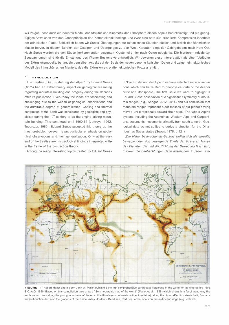
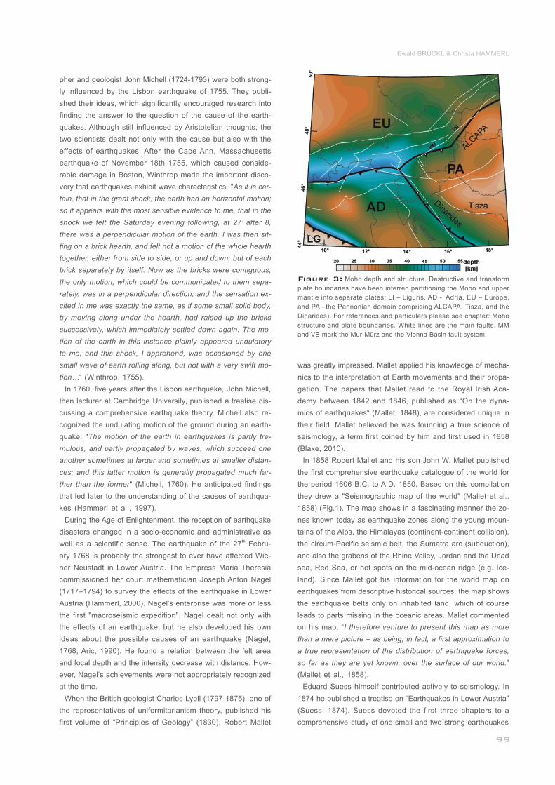
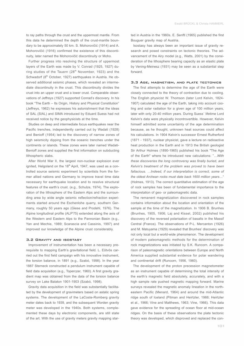
Figure 1: Robert Mallet and his son John W. Mallet published the first comprehensive earthquake catalogue of the world for the time-period 1606
B.C.-A.D. 1850. Based on this compilation they draw a "Seismographic map of the world" (Mallet et al., 1858) which shows in a fascinating way the
earthquake zones along the young mountains of the Alps, the Himalaya (continent-continent collision), along the circum-Pacific seismic belt, Sumatra
arc (subduction) but also the grabens of the Rhine Valley, Jordan – Dead sea, Red Sea, or hot spots on the mid-ocean ridge (e.g. Iceland)._________
Eduard Suess’ conception of the Alpine orogeny related to geophysical data and models
zelnen Falle ermitteln. …In dem appeninischen Zweige des
Alpensystems ist sie nach Norden gerichtet, in den Westal-
pen nach West, nach Nordwest, dann nach Nord, im Jura-
gebirge nach Nordwest, in den Ostalpen nach Nord, in dem
karpathischen Zweige nach Nordwest, nach Nord und endlich
nach Nordost, am äussersten Ende nach Ost, im ungarischen
Mittelgebirge nach Nordwest. In den croatisch-syrmischen
Höhenzügen ist sie wegen der Mangelhaftigkeit der Ausbil-
dung kaum erkennbar: für die dinarischen Alpen mangeln hin-
reichende Angaben.“
The direction of the movement is, according to Eduard Suess,
quite similar for Europe and North America. However, in Asia,
for the Himalayas in particular, he derives movements in the
opposite direction (Suess, 1875, p 131):
„Nur eine einseitige horizontale Verschiebung der Masse des
Gebirges (remark: Swiss molasse) kann diess hervorbringen;
die gleiche Ueberschiebung der subhimalayaschen Molasse
ist ein Zeichen, dass hier die allgemeine Bewegung gegen
Süd gerichtet ist.“
Most mountain chains, especially the Alpine-Himalaya sys-
tem, show a succession of arcs. Eduard Suess relates the
curvature of the individual chains to the direction of the unidi-
rectional movement. The Alps are convex to the north and the
movement comes from the south. The opposite is true for the
Himalayas (Suess, 1875, p 126):
“Alpen, Jura und Karpathen beschreiben in Europa von den
nach West gedrängten Massen der Westalpen bei Lyon bis
zu den nach Ost geschobenen äussersten Ketten der Karpa-
then an der Grenze der Moldau, grosse Bogenlinien, deren
Convexität nach Nord gerichtet ist ; mit Ausnahme der Beu-
gung der Alpen bei Wien kennt man uberhaupt in Europa
keine grössere Gebirgslinie, welche nach Sud convex wäre.
In Asien ist diess nicht so. Der Himalaya beschreibt mit sei-
nen Hauptketten eine nach Sudwest gewölbte Curve …“
The dominance of the asymmetry and unidirectionality of
mountain chains and the elegance of this conception does
not mislead Eduard Suess to oversimplify. For example, he
recognizes clearly that the architecture of the Southern Alps
does not follow the general scheme of one-sided northward
movement (Suess, 1875, p 86):
„Im Widerspruche mit Allem bisher Gesagten bemerkt man
im mittleren Europa auch da und dort einzelne Gebirgstheile
oder längere Streifen, welche gegen Süd oder Südwest über-
schoben oder überbogen sind.“
Eduard Suess describes the situation in the Val Sugana (Tren-
tino, Italy) and derives a southward-oriented movement in the
Southern Alps. However, he deems this reversal a subordinate
feature which does not bring into question the general polarity.
The Eastern Alps at their transition to the Carpathians show
convex curvature to the south as an exception. Eduard Suess
does not interpret this observation as a reversal of the general
trend of motion. He interprets the Bohemian Massif as a but-
tress against the masses approaching from the south. The
masses are deflected to the east, thus introducing tension
and forming the Vienna Basin (Suess, 1875, p 37):
_________________________________
_________________
___________________________________
_______________________
____
________________________
________________________
_________
„An der Südspitze der böhmischen Gebirgsmasse stauen
sich, wie wir oben sahen, die nördlichen Zonen der Ostalpen;
sobald sie dieses Hinderniss umgangen haben, schwenken
sie nach Nordost ab und bilden weiterhin in grosse, regelmäs-
sige Bogen über das galizische Plateau ausgebreitet, den
westlichen Theil des karpathischen Gebirges. Wo die Ablen-
kung am stärksten ist, entsteht wie durch Zerrung ein gewal-
tiger Riss, eine Lücke in der Gebirgskette, welche den Wäs-
sern der Nordabhänge ihren Abfluss gegen Süd öffnet und
welche wir als die inneralpine Niederung von Wien zu be-
zeichnen pflegen.“
In the following chapters we describe the state of Physics of
the Earth including Geodesy at the time of Eduard Suess’ “Die
Entstehung der Alpen”. We anticipate that the state of Physics
of the Earth during Eduard Suess’ work on this treatise with
the seismology as an exception provided no essential con-
straints on his conception of the origin of the Alps and compa-
rable mountain ranges. We review milestones in the geophy-
sical sciences since 1875 and address large-scale geophysi-
cal experiments that yielded substantial information on tran-
sects or profiles crossing the Alpine system as well as struc-
tural models of the Moho and the upper mantle. Quantitative
data on crustal movements in the past and at present are sup-
plied by paleomagnetic studies and geodetic campaigns, es-thpecially by GPS. On the occasion of the 100 anniversary of
the death of Eduard Suess we relate his ideas on mountain
building to modern geophysical data and models.
Navigation using a magnetic compass for purposes of ori-
entation was first used around 1000 AD in China (Needham, th1971) and later in Western Europe. In the 19 Century geo-
magnetics was already highly developed and of fundamental
importance for navigation.
In 1797 the Prussian geographer Alexander von Humboldt
(1769-1848) led a magnetic expedition to the Palatinate (Pfalz,
Germany), where he attributed the many anomalies he noticed
in the direction of his compass to the rocks near the summit.
He coined the terms “isodynamics” (lines of equal magnetic
intensity), “isoclines” (lines of equal magnetic dip), and “mag-
netic storm” (Courtillot et al., 2007).
During the late eighteenth and early nineteenth centuries, the
construction of non-magnetic huts for geomagnetic observa-
tion began. Early observations were carried out in many pla-
ces across and outside Europe, for example by the British mi-
litary engineer and cartographer John Macdonald (1759–1831)
in Fort Marlborough on Sumatra/Indonesia. At Greenwich Ob-
servatory from 1818 to 1820 the magnetic declination was
read thrice daily by the French astronomer François Arago
(1786-1853). Observations of the declination were recorded
at the Paris Astronomical Observatory from 1820 to 1835, as
well as at Kremsmünster Abbey (Upper Austria) from 1832, to
name just a few.
___________________________________
__________
____________________________
_____________________
____________________________________
2. Physics of the Earth at 1875
2.1 Geomagnetism
Ewald BRÜCKL & Christa HAMMERL
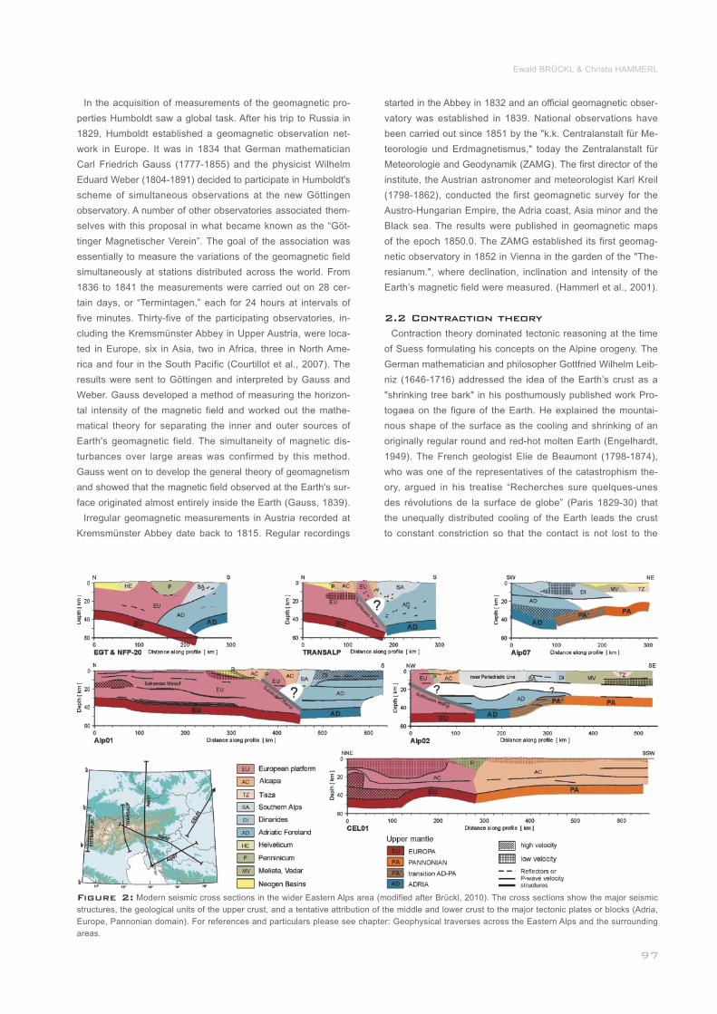
Figure 2: Modern seismic cross sections in the wider Eastern Alps area (modified after Brückl, 2010). The cross sections show the major seismic
structures, the geological units of the upper crust, and a tentative attribution of the middle and lower crust to the major tectonic plates or blocks (Adria,
Europe, Pannonian domain). For references and particulars please see chapter: Geophysical traverses across the Eastern Alps and the surrounding
areas.
In the acquisition of measurements of the geomagnetic pro-
perties Humboldt saw a global task. After his trip to Russia in
1829, Humboldt established a geomagnetic observation net-
work in Europe. It was in 1834 that German mathematician
Carl Friedrich Gauss (1777-1855) and the physicist Wilhelm
Eduard Weber (1804-1891) decided to participate in Humboldt's
scheme of simultaneous observations at the new Göttingen
observatory. A number of other observatories associated them-
selves with this proposal in what became known as the “Göt-
tinger Magnetischer Verein”. The goal of the association was
essentially to measure the variations of the geomagnetic field
simultaneously at stations distributed across the world. From
1836 to 1841 the measurements were carried out on 28 cer-
tain days, or “Termintagen,” each for 24 hours at intervals of
five minutes. Thirty-five of the participating observatories, in-
cluding the Kremsmünster Abbey in Upper Austria, were loca-
ted in Europe, six in Asia, two in Africa, three in North Ame-
rica and four in the South Pacific (Courtillot et al., 2007). The
results were sent to Göttingen and interpreted by Gauss and
Weber. Gauss developed a method of measuring the horizon-
tal intensity of the magnetic field and worked out the mathe-
matical theory for separating the inner and outer sources of
Earth's geomagnetic field. The simultaneity of magnetic dis-
turbances over large areas was confirmed by this method.
Gauss went on to develop the general theory of geomagnetism
and showed that the magnetic field observed at the Earth's sur-
face originated almost entirely inside the Earth (Gauss, 1839).
Irregular geomagnetic measurements in Austria recorded at
Kremsmünster Abbey date back to 1815. Regular recordings
started in the Abbey in 1832 and an official geomagnetic obser-
vatory was established in 1839. National observations have
been carried out since 1851 by the "k.k. Centralanstalt für Me-
teorologie und Erdmagnetismus," today the Zentralanstalt für
Meteorologie and Geodynamik (ZAMG). The first director of the
institute, the Austrian astronomer and meteorologist Karl Kreil
(1798-1862), conducted the first geomagnetic survey for the
Austro-Hungarian Empire, the Adria coast, Asia minor and the
Black sea. The results were published in geomagnetic maps
of the epoch 1850.0. The ZAMG established its first geomag-
netic observatory in 1852 in Vienna in the garden of the "The-
resianum.", where declination, inclination and intensity of the
Earth’s magnetic field were measured. (Hammerl et al., 2001).
Contraction theory dominated tectonic reasoning at the time
of Suess formulating his concepts on the Alpine orogeny. The
German mathematician and philosopher Gottfried Wilhelm Leib-
niz (1646-1716) addressed the idea of the Earth’s crust as a
"shrinking tree bark" in his posthumously published work Pro-
togaea on the figure of the Earth. He explained the mountai-
nous shape of the surface as the cooling and shrinking of an
originally regular round and red-hot molten Earth (Engelhardt,
1949). The French geologist Elie de Beaumont (1798-1874),
who was one of the representatives of the catastrophism the-
ory, argued in his treatise “Recherches sure quelques-unes
des révolutions de la surface de globe” (Paris 1829-30) that
the unequally distributed cooling of the Earth leads the crust
to constant constriction so that the contact is not lost to the
2.2 Contraction theory
diminishing interior mass. Another prominent representative of
the contraction theory was Alexander v. Humboldt (1769-1859).
In his work the “Kosmos” he depicted the origin of mountains
caused by folding of the crust due to the shrinking Earth (Ette
and Lubrich, 2004). Eduard Suess (1892) summarized the re-
sults of his concept of the Shrinking Earth theory in his main
publication “Das Antlitz der Erde” as follows: "Der Zusammen-
bruch des Erdballes ist es, dem wir beiwohnen… " (we observe
the collapse of our planet).
The geothermal gradient played an important role in contrac-
tion theory. The first geothermal temperature measurements
with a thermometer were likely carried out around 1740 by
the French engineer Antoine de Gensanne (?-1780) in a mine
near Belfort in France. In 1791 Alexander von Humboldt deter-
mined for the first time in history a temperature increase with
depth of 3.8 ° C per 100 m in the Freiberg mining district; the
geothermal gradient had been discovered. Confirmations in
Central and South America soon followed. During 1831 and
1863 temperature measurements were performed in deep
boreholes of up to 1000 m depth in Germany. A few years la-
ter first results with a depth of up to 1700 m were available.
An average temperature increase of 3 ° C per 100 meters was
observed, which we know today to be the normal temperature
gradient (Stober et al., 2012).
A concept that played an important role in classical oroge-
nesis was that of “geosyncline”, introduced by the American
geologists James Hall (1811-1898) in 1859 and James Dwight
Dana (1813–1895), representative of the principle of unifor-
mitarianism, in 1873. It was believed that sedimentary layers
were formed along with subsidence of long narrow zones where
various orogenic activities, including igneous and metamorphic
processes, would eventually occur. The strata would then be
deformed, elevated and would finally create the great moun-
tain ranges (Lee et al., 2002).
In 1873 Dana attributed the sinking of the oceanic basins
between the continental blocks to differential regional cooling,
caused by different thermal conductivities of the rocks. This
method allowed for the creation of mountains and also the ori-
gin of earthquakes (Dana, 1873). Dana’s geosynclinal theory
remained the relevant tectonic explanation model until well in-
to the 20th century. It was Eduard Suess with his work “Ent-
stehung der Alpen“ who helped to get such ideas accepted in
Europe, but not without critical examination.
Hall's idea of the development of geosynclines was only rea-
sonable if one could imagine a viscous or liquid subsurface
instead of a cooling rigid bedrock, from which magma would
rise into the bottom of the geosyncline. In a letter to the geolo-
gist Charles Lyell (1797-1875) the astronomer John Herschel
(1792-1871) speculated that the outermost layer of crust of
the Earth was in a form of dynamic equilibrium with its under-
lying substratum or sea of lava (e.g., Watts, 2001), thus antic-
ipating the idea of isostasy. This idea was cast into a physical
model by the British astronomer George Biddell Airy (1801-
____________________________
__________________________
__________________________
______________
2.3 Geosynclines, isostasy and gravity
1892). According to this model, parts of the thickened earth’s
crust are immersed like floating trunks or sheets of ice in the
water (Airy, 1855).
Before Airy first developed his ideas the French mathemati-
cian, geophysicist, geodesist, and astronomer Pierre Bouguer
(1698-1758) led an expedition in 1738 to Peru, where in the
vicinity of Mount Chimborazo (6250 m) he investigated the ver-
tical deflection. Bouguer and de La Condamine (1749) publi-
shed their research on the expedition in “La figure de la terre”.
In the last part of the book Bouguer dealt with gravity mea-
surements. In order to process the data from the summit of
Pichincha, Quito and the coast he applied for the first time
two reductions, which are today known as the Free-air and
Bouguer reductions.
Airy built his thesis on the results of gravity measurements
made with a plumb-line, which were carried out south of the
Himalayas in the same year by the English clergyman and
mathematician John Henry Pratt (1809-1871). These measure-
ments did not show significant gravitational pull of the moun-
tains, which had initially been expected due to the height diffe-
rence between the mountains and surroundings (Hölder, 1989).
Pratt developed an alternative model for isostatic compensa-
tion, widely used in Geodesy.
One fundamental achievement of seismology was to resolve
the shell structure of the Earth and the structure of the crust
and lithosphere. These findings, however, only became pos-
sible with the development of effective seismographs. At the
time of Eduard Suess’ "Entstehung der Alpen" (1875), such
instruments were only in use in testing or development and
none of the instruments provided the required sensitivity, time
stamp or continuous recording. According to Dewey and By-
erly (1969), the first "true" seismograph, i.e. a device that re-
corded the relative motion of an inertial mass and the Earth
as a function of time, was the instrument built in 1875 by the
Italian seismologist P. F. Cecchi.
Many myths, legends and theories arose around historical
earthquake disasters. Various attempts were made to develop
plausible theories to explain the processes in the earth. Influ-
enced by zeitgeist and culture, diverse concepts emerged. The th ststrongest earthquake of the 18 Century on 1 November 1755
in Lisbon/Portugal forced the discussion regarding the causes
of earthquakes. Not only the German philosopher Immanuel
Kant (1724-1804) published his treatise on the causes of earth-
quakes (Kant, 1756), but also many other authors like Voltaire
(1694-1778) and Jean-Jacques Rousseau (1712-1778) dealt
with the disaster. Additionally, numerous reports in newspa-
pers, sermons and poems were issued in the following years
(Oeser, 2003). Kant contradicted in his work the then common
view that earthquakes were caused by certain planetary con-
stellations and thus denied any mystical or religious explana-
tion. Instead, he gave a chemical explanation.
John Winthrop (1714-1779), professor of mathematics and
natural philosophy in Harvard, and the English natural philoso-
___________________________________
_________________________________
__________________________
________________________
____________
2.4 Seismology
Eduard Suess’ conception of the Alpine orogeny related to geophysical data and models
pher and geologist John Michell (1724-1793) were both strong-
ly influenced by the Lisbon earthquake of 1755. They publi-
shed their ideas, which significantly encouraged research into
finding the answer to the question of the cause of the earth-
quakes. Although still influenced by Aristotelian thoughts, the
two scientists dealt not only with the cause but also with the
effects of earthquakes. After the Cape Ann, Massachusetts
earthquake of November 18th 1755, which caused conside-
rable damage in Boston, Winthrop made the important disco-
very that earthquakes exhibit wave characteristics, “As it is cer-
tain, that in the great shock, the earth had an horizontal motion;
so it appears with the most sensible evidence to me, that in the
shock we felt the Saturday evening following, at 27’ after 8,
there was a perpendicular motion of the earth. I was then sit-
ting on a brick hearth, and felt not a motion of the whole hearth
together, either from side to side, or up and down; but of each
brick separately by itself. Now as the bricks were contiguous,
the only motion, which could be communicated to them sepa-
rately, was in a perpendicular direction; and the sensation ex-
cited in me was exactly the same, as if some small solid body,
by moving along under the hearth, had raised up the bricks
successively, which immediately settled down again. The mo-
tion of the earth in this instance plainly appeared undulatory
to me; and this shock, I apprehend, was occasioned by one
small wave of earth rolling along, but not with a very swift mo-
tion…“ (Winthrop, 1755).
In 1760, five years after the Lisbon earthquake, John Michell,
then lecturer at Cambridge University, published a treatise dis-
cussing a comprehensive earthquake theory. Michell also re-
cognized the undulating motion of the ground during an earth-
quake: "The motion of the earth in earthquakes is partly tre-
mulous, and partly propagated by waves, which succeed one
another sometimes at larger and sometimes at smaller distan-
ces; and this latter motion is generally propagated much far-
ther than the former" (Michell, 1760). He anticipated findings
that led later to the understanding of the causes of earthqua-
kes (Hammerl et al., 1997).
During the Age of Enlightenment, the reception of earthquake
disasters changed in a socio-economic and administrative as thwell as a scientific sense. The earthquake of the 27 Febru-
ary 1768 is probably the strongest to ever have affected Wie-
ner Neustadt in Lower Austria. The Empress Maria Theresia
commissioned her court mathematician Joseph Anton Nagel
(1717–1794) to survey the effects of the earthquake in Lower
Austria (Hammerl, 2000). Nagel’s enterprise was more or less
the first "macroseismic expedition". Nagel dealt not only with
the effects of an earthquake, but he also developed his own
ideas about the possible causes of an earthquake (Nagel,
1768; Aric, 1990). He found a relation between the felt area
and focal depth and the intensity decrease with distance. How-
ever, Nagel’s achievements were not appropriately recognized
at the time.
When the British geologist Charles Lyell (1797-1875), one of
the representatives of uniformitarianism theory, published his
first volume of “Principles of Geology” (1830), Robert Mallet
______________________________
___________________________
was greatly impressed. Mallet applied his knowledge of mecha-
nics to the interpretation of Earth movements and their propa-
gation. The papers that Mallet read to the Royal Irish Aca-
demy between 1842 and 1846, published as “On the dyna-
mics of earthquakes“ (Mallet, 1848), are considered unique in
their field. Mallet believed he was founding a true science of
seismology, a term first coined by him and first used in 1858
(Blake, 2010).
In 1858 Robert Mallet and his son John W. Mallet published
the first comprehensive earthquake catalogue of the world for
the period 1606 B.C. to A.D. 1850. Based on this compilation
they drew a "Seismographic map of the world" (Mallet et al.,
1858) (Fig.1). The map shows in a fascinating manner the zo-
nes known today as earthquake zones along the young moun-
tains of the Alps, the Himalayas (continent-continent collision),
the circum-Pacific seismic belt, the Sumatra arc (subduction),
and also the grabens of the Rhine Valley, Jordan and the Dead
sea, Red Sea, or hot spots on the mid-ocean ridge (e.g. Ice-
land). Since Mallet got his information for the world map on
earthquakes from descriptive historical sources, the map shows
the earthquake belts only on inhabited land, which of course
leads to parts missing in the oceanic areas. Mallet commented
on his map, “I therefore venture to present this map as more
than a mere picture – as being, in fact, a first approximation to
a true representation of the distribution of earthquake forces,
so far as they are yet known, over the surface of our world.”
(Mallet et al., 1858).
Eduard Suess himself contributed actively to seismology. In
1874 he published a treatise on “Earthquakes in Lower Austria”
(Suess, 1874). Suess devoted the first three chapters to a
comprehensive study of one small and two strong earthquakes
_________________________________
Ewald BRÜCKL & Christa HAMMERL
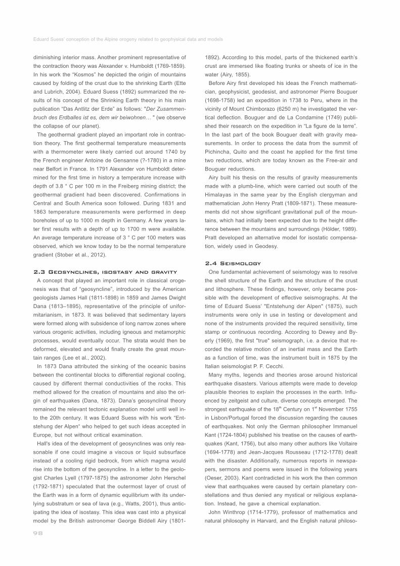
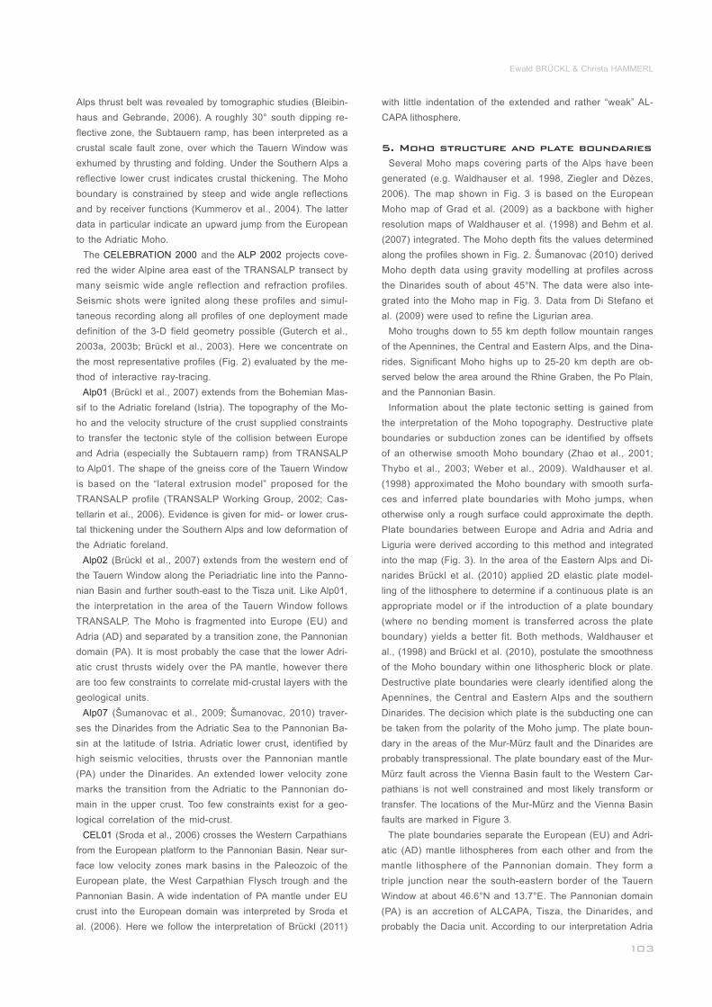
Figure 3: Moho depth and structure. Destructive and transform
plate boundaries have been inferred partitioning the Moho and upper
mantle into separate plates: LI – Liguris, AD - Adria, EU – Europe,
and PA –the Pannonian domain comprising ALCAPA, Tisza, and the
Dinarides). For references and particulars please see chapter: Moho
structure and plate boundaries. White lines are the main faults. MM
and VB mark the Mur-Mürz and the Vienna Basin fault system.______
Eduard Suess’ conception of the Alpine orogeny related to geophysical data and models
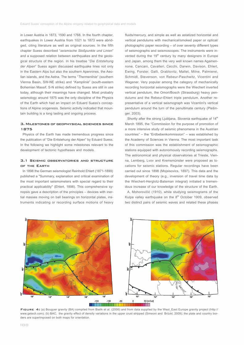
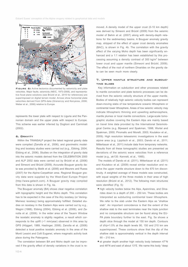
Figure 4: (a) Bouguer gravity (BA) compiled from Bielik et al. (2006) and from data supplied by the West_East Europe gravity project (http://
www.getech.com); (b) BAC, the gravity effect of density variations in the upper crust stripped (Simeoni and Brückl, 2009); the plate and country bor-
ders are superimposed on both maps for orientation.______________________________________________________________________________
in Lower Austria in 1873, 1590 and 1768. In the fourth chapter,
earthquakes in Lower Austria from 1021 to 1873 were abrid-
ged, citing literature as well as original sources. In the fifth
chapter Suess described “seismische Stoßpunkte und Linien”
and a supposed relation between earthquakes and the geolo-
gical structure of the region. In his treatise “Die Entstehung
der Alpen“ Suess again discussed earthquake lines not only
in the Eastern Alps but also the southern Apennines, the Aeo-
lian islands, and the Aetna. The terms “Thermenlinie“ (southern
Vienna Basin, SW-NE strike) and “Kamplinie” (south-eastern
Bohemian Massif, S-N strike) defined by Suess are still in use
today, although their meanings have changed. Most probably
seismology around 1875 was the only discipline of the Physics
of the Earth which had an impact on Eduard Suess’s concep-
tions of Alpine orogenesis. Seismic activity indicated that moun-
tain building is a long lasting and ongoing process.
Physics of the Earth has made tremendous progress since
the publication of “Die Entstehung der Alpen” by Eduard Suess.
In the following we highlight some milestones relevant to the
development of tectonic hypotheses and models.
In 1898 the German seismologist Reinhold Ehlert (1871-1899)
published a "Summary, explanation and critical examination of
the most important seismometers with special regard to their
practical applicability" (Ehlert, 1898). This comprehensive sy-
nopsis gave a description of the principles – devices with iner-
tial masses moving on ball bearings on horizontal plates, ins-
truments indicating or recording surface motions of heavy
_________
__________
3. Milestones of geophysical sciences since
1875
3.1 Seismic observatories and structure
of the Earth
fluids/mercury, and simple as well as astatized horizontal and
vertical pendulums with mechanical/smoked paper or optical/
photographic paper recording – of over seventy different types
of seismographs and seismoscopes. The instruments were in-thvented during the 19 century by many designers in Europe
and Japan, among them the very well known names Agamen-
none, Cancani, Cavalleri, Cecchi, Darwin, Davison, Ehlert,
Ewing, Forster, Galli, Grablovitz, Mallet, Milne, Palmierei,
Schmidt, Stevenson, von Rebeur-Paschwitz, Vicentini and
Wagener. Very popular among the category of mechanically
recording horizontal seismographs were the Wiechert inverted
vertical pendulum, the Omori/Bosch (Strassburg) heavy pen-
dulums and the Rebeur-Ehlert triple pendulum. Another re-
presentative of a vertical seismograph was Vicentini's vertical
pendulum around the turn of the penultimate century (Plešin-
ger, 2003).thShortly after the strong Ljubljana, Slovenia earthquake of 14
March 1895, the “Commission for the purpose of promotion of
a more intensive study of seismic phenomena in the Austrian
countries” – the “Erdbebenkommission” – was established by
the Academy of Sciences in Vienna. The most important task
of this commission was the establishment of seismographic
stations equipped with autonomously recording seismographs.
The astronomical and physical observatories at Trieste, Vien-
na, Lemberg, Lvov and Kremsmünster were proposed as lo-
cations for seismic stations. Regular recordings have been
carried out since 1898 (Mojsisovics, 1897). This data and the
development of theory (e.g., inversion of travel time data by
the Wiechert-Herglotz-Bateman integral) initiated a tremen-
dous increase of our knowledge of the structure of the Earth.
A. Mohorovičić (1910), while studying seismograms of the thKulpa valley earthquake on the 8 October 1909, observed
two distinct pairs of seismic waves and related these phases
Ewald BRÜCKL & Christa HAMMERL
to ray paths through the crust and the uppermost mantle. From
this data he determined the depth of the crust-mantle boun-
dary to be approximately 50 km. S. Mohorovičić (1914) and A.
Mohorovičić (1916) confirmed the existence of this disconti-
nuity, later named the Mohorovičić discontinuity or Moho.
Further progress into resolving the structure of uppermost
layers of the Earth was made by V. Conrad (1925, 1927) du-thring studies of the Tauern (28 November, 1923) and the
thSchwadorf (8 October, 1927) earthquakes in Austria. He ob-
served additional seismic phases, which revealed an interme-
diate discontinuity in the crust. This discontinuity divides the
crust into an upper crust and a lower crust. Comparable obser-
vations of Jeffreys (1927) supported Conrad’s discovery. In his
book “The Earth – Its Origin, History and Physical Constitution”
(Jeffreys, 1962) he expresses his astonishment that the ideas
of SAL (SIAL) and SIMA introduced by Eduard Suess had not
received notice by the geophysicists at the time.
Studies on deep and intermediate focus earthquakes near the
Pacific trenches, independently carried out by Wadati (1928)
and Benioff (1954) led to the discovery of narrow zones of
high seismicity dipping from the oceanic trenches under the
continents or islands. These zones were later named Wadati-
Benioff zones and supplied the first information on subducting
lithospheric slabs.
After World War II, the largest non-nuclear explosion ever thignited, Helgoland on the 18 April, 1947, was used as a con-
trolled source seismic experiment by scientists from the for-
mer allied nations and Germany to improve travel time data
necessary for earthquake location and to resolve structural
features of the earth’s crust. (e.g., Schulze, 1974). The explo-
ration of the lithosphere of the Eastern Alps and the surroun-
ding area by wide angle seismic reflection/refraction experi-
ments started around the Eschenlohe quarry, southern Ger-
many, roughly 50 years ago (Giese and Prodehl, 1976). The
Alpine longitudinal profile (ALP'75) extended along the axis of
the Western and Eastern Alps to the Pannonian Basin (e.g.,
Yan and Mechie, 1989; Scarascia and Cassinis, 1997) and
improved our knowledge of the Alpine crust considerably.
Improvement of instrumentation has been a necessary pre-
requisite to mapping Earth’s gravitational field. L. Eötvös car-
ried out the first field campaign with his innovative instrument,
the torsion balance, in 1891 (e.g., Szabó, 1998). In the year
1887 Sterneck constructed a pendulum instrument capable of
field data acquisition (e.g., Toperczer, 1960). A first gravity gra-
dient map was obtained from the data of the torsion balance
survey on Lake Balaton 1901-1903 (Szabó, 1998).
Gravity data acquisition in the field was substantially facilita-
ted by the development of gravimeters based on astatic spring
systems. The development of the LaCoste-Romberg gravity
meter dates back to 1939, and the subsequent Worden gravity
meter was developed in the 1940s. Both systems, comple-
mented these days by electronic components, are still state
of the art. With the use of gravity meters gravity mapping star-
____
___________
___________________________________
___
_________
3.2 Gravity and isostasy
ted in Austria in the 1960s. E. Senftl (1965) published the first
Bouguer gravity map of Austria.
Isostasy has always been an important issue of gravity re-
search and posed constraints on tectonic theories. The ad-
vancement of the Airy model (e.g., Watts, 2001) by the consi-
deration of the lithosphere bearing capacity as an elastic plate
by Vening-Meinesz (1931) may be seen as a substantial step
forward.
The first attempts to determine the age of the Earth were
closely connected to the theory of contraction due to cooling.
The English physicist W. Thomson (later Lord Kelvin, 1824-
1907) calculated the age of the Earth, taking into account coo-
ling and solar radiation for a given age of 100 million years,
later with only 20-40 million years. During Suess´ lifetime Lord
Kelvin's data were physically incontrovertible. However, Kelvin
himself admitted some uncertainty of the age determination
because, as he thought, unknown heat sources could affect
his calculations. In 1904 Kelvin’s successor Ernest Rutherford
(1871 - 1937), nuclear physicist, gave a lecture on radioactive
heat production in the Earth and in 1913 the British geologist
Sir Arthur Holmes (1890-1965) published his book "The Age
of the Earth" where he introduced new calculations: ”…With
these discoveries the long controversy was finally buried, and
Kelvin's treatment of the problem was proved to have been
fallacious. …Indeed, if our interpretation is correct, some of
the oldest Archean rocks must date back 1600 million years…“
(Holmes, 1913). The correct quantitative estimation of the age
of rock samples has been of fundamental importance to the
interpretation of geo- or paleomagnetic data.
The remanent magnetization discovered in rock samples
contains information about the location and orientation of the
sample at the time of the magnetization. In 1906 B. Brunhes
(Brunhes, 1905, 1906; Laj and Kissel, 2002) published his
discovery of the reversed polarisation of basalts in the Massif
Central (France). The observations of P-L. Mercanton (1926)
and M. Matuyama (1929) revealed that Brunhes’ discovery was
not only local but a world-wide phenomenon. The development
of modern paleomagnetic methods for the determination of
rock magnetizations was initiated by S.K. Runcorn. A compa-
rison of paleomagnetic orientations between Europe and North
America supplied substantial evidence for polar wandering
and continental drift (Runcorn, 1956, 1960).
The development of the proton precession magnetometer
as an instrument capable of determining the total intensity of
the earth’s magnetic field absolutely, accurately, and with a
high sample rate pushed magnetic mapping forward. Marine
surveys revealed the magnetic anomaly lineation in the north-
eastern Pacific (Menard, 1964) and around the mid-Atlantic
ridge south of Iceland (Pitman and Heirtzler, 1966; Heirtzler
et al., 1966; Vine and Matthews, 1963; Vine, 1966). This data
gave evidence for the spreading of ocean floor at mid-ocean
ridges. On the basis of these observations the plate tectonic
theory was developed, which disproved and replaced the con-
________________________
______________
______________
3.3 Age, magnetism, and plate tectonics
Eduard Suess’ conception of the Alpine orogeny related to geophysical data and models
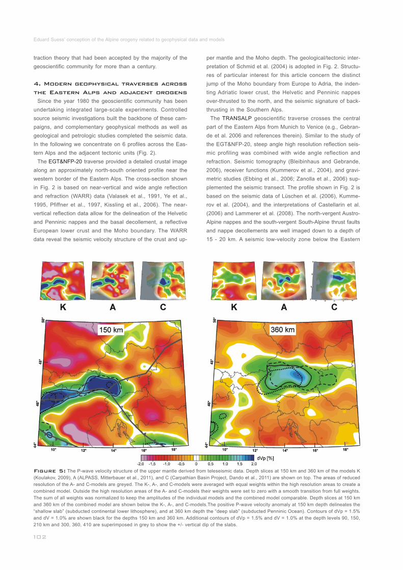
Figure 5: The P-wave velocity structure of the upper mantle derived from teleseismic data. Depth slices at 150 km and 360 km of the models K
(Koulakov, 2009), A (ALPASS, Mitterbauer et al., 2011), and C (Carpathian Basin Project, Dando et al., 2011) are shown on top. The areas of reduced
resolution of the A- and C-models are greyed. The K-, A-, and C-models were averaged with equal weights within the high resolution areas to create a
combined model. Outside the high resolution areas of the A- and C-models their weights were set to zero with a smooth transition from full weights.
The sum of all weights was normalized to keep the amplitudes of the individual models and the combined model comparable. Depth slices at 150 km
and 360 km of the combined model are shown below the K-, A-, and C-models.The positive P-wave velocity anomaly at 150 km depth delineates the
“shallow slab” (subducted continental lower lithosphere), and at 360 km depth the “deep slab” (subducted Penninic Ocean). Contours of dVp = 1.5%
and dV = 1.0% are shown black for the depths 150 km and 360 km. Additional contours of dVp = 1.5% and dV = 1.0% at the depth levels 90, 150,
210 km and 300, 360, 410 are superimposed in grey to show the +/- vertical dip of the slabs._____________________________________________
traction theory that had been accepted by the majority of the
geoscientific community for more than a century.
Since the year 1980 the geoscientific community has been
undertaking integrated large-scale experiments. Controlled
source seismic investigations built the backbone of these cam-
paigns, and complementary geophysical methods as well as
geological and petrologic studies completed the seismic data.
In the following we concentrate on 6 profiles across the Eas-
tern Alps and the adjacent tectonic units (Fig. 2).
The traverse provided a detailed crustal image
along an approximately north-south oriented profile near the
western border of the Eastern Alps. The cross-section shown
in Fig. 2 is based on near-vertical and wide angle reflection
and refraction (WARR) data (Valasek et al., 1991, Ye et al.,
1995, Pfiffner et al., 1997, Kissling et al., 2006). The near-
vertical reflection data allow for the delineation of the Helvetic
and Penninic nappes and the basal decollement, a reflective
European lower crust and the Moho boundary. The WARR
data reveal the seismic velocity structure of the crust and up-
__________
__________
4. Modern geophysical traverses across
the Eastern Alps and adjacent orogens
EGT&NFP-20
per mantle and the Moho depth. The geological/tectonic inter-
pretation of Schmid et al. (2004) is adopted in Fig. 2. Structu-
res of particular interest for this article concern the distinct
jump of the Moho boundary from Europe to Adria, the inden-
ting Adriatic lower crust, the Helvetic and Penninic nappes
over-thrusted to the north, and the seismic signature of back-
thrusting in the Southern Alps.
The geoscientific traverse crosses the central
part of the Eastern Alps from Munich to Venice (e.g., Gebran-
de et al. 2006 and references therein). Similar to the study of
the EGT&NFP-20, steep angle high resolution reflection seis-
mic profiling was combined with wide angle reflection and
refraction. Seismic tomography (Bleibinhaus and Gebrande,
2006), receiver functions (Kummerov et al., 2004), and gravi-
metric studies (Ebbing et al., 2006; Zanolla et al., 2006) sup-
plemented the seismic transect. The profile shown in Fig. 2 is
based on the seismic data of Lüschen et al. (2006), Kumme-
rov et al. (2004), and the interpretations of Castellarin et al.
(2006) and Lammerer et al. (2008). The north-vergent Austro-
Alpine nappes and the south-vergent South-Alpine thrust faults
and nappe decollements are well imaged down to a depth of
15 - 20 km. A seismic low-velocity zone below the Eastern
_________________________
TRANSALP
Ewald BRÜCKL & Christa HAMMERL
Alps thrust belt was revealed by tomographic studies (Bleibin-
haus and Gebrande, 2006). A roughly 30° south dipping re-
flective zone, the Subtauern ramp, has been interpreted as a
crustal scale fault zone, over which the Tauern Window was
exhumed by thrusting and folding. Under the Southern Alps a
reflective lower crust indicates crustal thickening. The Moho
boundary is constrained by steep and wide angle reflections
and by receiver functions (Kummerov et al., 2004). The latter
data in particular indicate an upward jump from the European
to the Adriatic Moho.
The and the projects cove-
red the wider Alpine area east of the TRANSALP transect by
many seismic wide angle reflection and refraction profiles.
Seismic shots were ignited along these profiles and simul-
taneous recording along all profiles of one deployment made
definition of the 3-D field geometry possible (Guterch et al.,
2003a, 2003b; Brückl et al., 2003). Here we concentrate on
the most representative profiles (Fig. 2) evaluated by the me-
thod of interactive ray-tracing.
(Brückl et al., 2007) extends from the Bohemian Mas-
sif to the Adriatic foreland (Istria). The topography of the Mo-
ho and the velocity structure of the crust supplied constraints
to transfer the tectonic style of the collision between Europe
and Adria (especially the Subtauern ramp) from TRANSALP
to Alp01. The shape of the gneiss core of the Tauern Window
is based on the “lateral extrusion model” proposed for the
TRANSALP profile (TRANSALP Working Group, 2002; Cas-
tellarin et al., 2006). Evidence is given for mid- or lower crus-
tal thickening under the Southern Alps and low deformation of
the Adriatic foreland.
(Brückl et al., 2007) extends from the western end of
the Tauern Window along the Periadriatic line into the Panno-
nian Basin and further south-east to the Tisza unit. Like Alp01,
the interpretation in the area of the Tauern Window follows
TRANSALP. The Moho is fragmented into Europe (EU) and
Adria (AD) and separated by a transition zone, the Pannonian
domain (PA). It is most probably the case that the lower Adri-
atic crust thrusts widely over the PA mantle, however there
are too few constraints to correlate mid-crustal layers with the
geological units.
(Šumanovac et al., 2009; Šumanovac, 2010) traver-
ses the Dinarides from the Adriatic Sea to the Pannonian Ba-
sin at the latitude of Istria. Adriatic lower crust, identified by
high seismic velocities, thrusts over the Pannonian mantle
(PA) under the Dinarides. An extended lower velocity zone
marks the transition from the Adriatic to the Pannonian do-
main in the upper crust. Too few constraints exist for a geo-
logical correlation of the mid-crust.
(Sroda et al., 2006) crosses the Western Carpathians
from the European platform to the Pannonian Basin. Near sur-
face low velocity zones mark basins in the Paleozoic of the
European plate, the West Carpathian Flysch trough and the
Pannonian Basin. A wide indentation of PA mantle under EU
crust into the European domain was interpreted by Sroda et
al. (2006). Here we follow the interpretation of Brückl (2011)
_________________________________
_________________________
_________________________________
____________________________________
_____________________
CELEBRATION 2000 ALP 2002
Alp01
Alp02
Alp07
CEL01
with little indentation of the extended and rather “weak” AL-
CAPA lithosphere.
Several Moho maps covering parts of the Alps have been
generated (e.g. Waldhauser et al. 1998, Ziegler and Dèzes,
2006). The map shown in Fig. 3 is based on the European
Moho map of Grad et al. (2009) as a backbone with higher
resolution maps of Waldhauser et al. (1998) and Behm et al.
(2007) integrated. The Moho depth fits the values determined
along the profiles shown in Fig. 2. Šumanovac (2010) derived
Moho depth data using gravity modelling at profiles across
the Dinarides south of about 45°N. The data were also inte-
grated into the Moho map in Fig. 3. Data from Di Stefano et
al. (2009) were used to refine the Ligurian area.
Moho troughs down to 55 km depth follow mountain ranges
of the Apennines, the Central and Eastern Alps, and the Dina-
rides. Significant Moho highs up to 25-20 km depth are ob-
served below the area around the Rhine Graben, the Po Plain,
and the Pannonian Basin.
Information about the plate tectonic setting is gained from
the interpretation of the Moho topography. Destructive plate
boundaries or subduction zones can be identified by offsets
of an otherwise smooth Moho boundary (Zhao et al., 2001;
Thybo et al., 2003; Weber et al., 2009). Waldhauser et al.
(1998) approximated the Moho boundary with smooth surfa-
ces and inferred plate boundaries with Moho jumps, when
otherwise only a rough surface could approximate the depth.
Plate boundaries between Europe and Adria and Adria and
Liguria were derived according to this method and integrated
into the map (Fig. 3). In the area of the Eastern Alps and Di-
narides Brückl et al. (2010) applied 2D elastic plate model-
ling of the lithosphere to determine if a continuous plate is an
appropriate model or if the introduction of a plate boundary
(where no bending moment is transferred across the plate
boundary) yields a better fit. Both methods, Waldhauser et
al., (1998) and Brückl et al. (2010), postulate the smoothness
of the Moho boundary within one lithospheric block or plate.
Destructive plate boundaries were clearly identified along the
Apennines, the Central and Eastern Alps and the southern
Dinarides. The decision which plate is the subducting one can
be taken from the polarity of the Moho jump. The plate boun-
dary in the areas of the Mur-Mürz fault and the Dinarides are
probably transpressional. The plate boundary east of the Mur-
Mürz fault across the Vienna Basin fault to the Western Car-
pathians is not well constrained and most likely transform or
transfer. The locations of the Mur-Mürz and the Vienna Basin
faults are marked in Figure 3.
The plate boundaries separate the European (EU) and Adri-
atic (AD) mantle lithospheres from each other and from the
mantle lithosphere of the Pannonian domain. They form a
triple junction near the south-eastern border of the Tauern
Window at about 46.6°N and 13.7°E. The Pannonian domain
(PA) is an accretion of ALCAPA, Tisza, the Dinarides, and
probably the Dacia unit. According to our interpretation Adria
5. Moho structure and plate boundaries
___________
_____________________________
__________________________
represents the lower plate with respect to Liguria and the Pan-
nonian domain and the upper plate with respect to Europe.
This scheme was earlier inferred by Doglioni and Carminati
(2002).
Within the TRANSALP project the latest regional gravity data
were compiled (Zanolla et al., 2006), and gravimetric model-
ling and isostasy studies were carried out (e.g., Ebbing, 2004;
Ebbing et al., 2006). Studies on the integration of gravity data
into the seismic models derived from the CELEBRATION 2000
and ALP 2002 data were carried out by Brückl et al. (2006)
and Simeoni and Brückl (2009). Accurate Bouguer gravity da-
ta was provided by Bielik et al. (2006) and Meurers and Ruess
(2007) for the Alpine-Carpathian area. Regional Bouguer gra-
vity data were supplied by the West-East Europe Project
(http://www.getech.com). A Bouguer gravity map compiled
from this data is shown in Fig. 4a.
The Bouguer anomaly (BA) shows clear negative correlation
with topographic height and the Moho depth. This correlation
has to be expected in the case of the Airy isostasy (or Vening-
Meinesz isostasy) being approximately fulfilled. Detailed stu-
dies on isostasy in the Eastern Alps were carried out by e.g.,
Wagini (1988), Ebbing (2004), Ebbing et al. (2006), and Za-
nolla et al. (2006). In the wider area of the Tauern Window
the isostatic anomaly is slightly negative, a result which cor-
responds to the uplift (~1 mm/year) observed in this area by
GPS (Höggerl, 1989, Haslinger, 2006). Zanolla et al. (2006)
detected a local positive isostatic anomaly in the area of the
Monti Lessini and Colli Euganei, where magmatic activity took
place during the Paleogene.
The correlation between BA and Moho depth can be impro-
ved if the gravity effect of density variations in the crust is re-
6. Gravity
______________________
___________________________
Eduard Suess’ conception of the Alpine orogeny related to geophysical data and models
Figure 6: Active tectonics documented by seismicity and plate
velocities. Major faults, seismicity (NEIC, 1973-2008), and representa-
tive focal plane solutions (see Brückl et al., 2010 for references) are
superimposed on digital terrain model. Arrows show horizontal plate
velocities derived from GPS-data (Grenerczy and Kenyeres, 2006;
Weber et al., 2006) relative to Europe._________________________
moved. A density model of the upper crust (0-10 km depth)
was derived by Simeoni and Brückl (2009) from the seismic
model of Behm et al. (2007) along with density-depth rela-
tions for the sedimentary basins. A Bouguer anomaly gravity
map, stripped of the effect of upper crust density anomalies
(BAC), is shown in Fig. 4b. The correlation with the gravity
effect of the varying Moho depth has been significantly en-
hanced and a 1:1 relation has been established by this pro-3cessing assuming a density contrast of 300 kg/m between
lower crust and upper mantle (Simeoni and Brückl, 2009).
The effect of the root of northern Dinarides on the gravity da-
ta can be seen much more clearly.
Key information on subduction and other processes related
to mantle convection and plate tectonic processes can be de-
rived from the seismic velocity structure of the upper mantle.
Bodies of relatively high seismic velocity bodies can represent
down-moving slabs of low temperature oceanic lithosphere or
continental lower lithosphere. Areas of low seismic velocity may
indicate lithospheric thinning and upwelling asthenosphere,
mantle plumes or local mantle convections. Large-scale tomo-
graphic studies covering the Eastern Alps are mainly based
on travel time data provided by the International Seismolo-
gical Centre (e.g. Bijwaard and Spakman, 1998; Wortel and
Spakman, 2000; Piromallo and Morelli, 2003; Koulakov et al.,
2009). High resolution teleseismic investigations in the east
alpine area (e.g. Lippitsch et al., 2003; Dando et al., 2011;
Mitterbauer et al., 2011) include data from temporary networks.
Results from all these tomographic studies are presented as
deviations of the seismic wave velocities from a reference
model (e.g., ak135: Kennett, et al., 1995).
The models of Dando et al. (2011), Mitterbauer et al. (2011)
and Koulakov et al. (2009) reveal similar resolution and re-
solve the upper mantle structure down to the 670 km discon-
tinuity. A weighted average of these models was constructed,
with equal weights of the three models in their area of high
resolution (Brückl et al., 2012). The following main structures
were identified (Fig. 5):
high velocity bodies below the Alps, Apennines, and Dina-
rides down to a depth of 200 – 250 km. These bodies are
interpreted as subducting continental lower lithosphere.
We refer to the slab under the Eastern Alps as “shallow
slab”. An important coincidence is that the extent of the
shallow slab to the east terminates near the triple junction
and no comparable structure can be found along the EU-
PA plate boundary further to the east. Fig. 5a shows a
depth slice through the model at 150 km depth. Contours
of dVp=1.5% at the depth levels 90, 150 and 210 km are
superimposed. These contours show that the dip of the
shallow slab is approximately vertical in the depth interval
90 – 210 km.
at greater depth another high velocity body between 47°N
and 48°N and east of about 13°E. We name this body “deep
_____________________
________________
_______________________________
7. Upper mantle structure and subduc-
ting slabs
Ewald BRÜCKL & Christa HAMMERL
slab” and interpret it as subducted and detached oceanic
lithosphere of the Penninic Ocean (Alpine Tethys) sinking
down to the 670 km mantle discontinuity (Dando et al, 2011).
Fig. 5b shows a depth slice through the model at 360 km
depth. Contours of dVp=1.0% at the depth levels 300, 360,
and 410 km are superimposed. These contours show that
the deep slab dips also subvertically in the depth interval
300 – 410 km and extends to the east with increasing depth.
Synthetic tests with the ALPASS data set show that sepa-
rated shallow and deep slabs appear connected because
of the limited vertical resolution (Mitterbauer, pers. commu-
nication).
The shape of the shallow slab as determined by the models
of Dando et al. (2011), Mitterbauer et al. (2011) and Koulakov
et al. (2009) agrees with the model of Lippitsch et al. (2003),
west of about 13°E. Further to the east the model of Lippitsch
shows the shallow slab dipping about 60° to the north-east. A
change of subduction polarity has been inferred by Lippitsch
et al. (2003) from this image of the slab. The model of Lip-
pitsch et al. (2003) ends at 400 km depth and does not re-
solve the deep slab under the Eastern Alps. We prefer the
models of Dando et al. (2011), Mitterbauer et al. (2011) and
Koulakov et al. (2009) and their combination because they
have denser coverage of ray-paths in this area and extend
down to the 670 km discontinuity. The idea of a subduction
polarity reversal is not supported by these models.
The evolution of the Alpine mountain system is closely rela-
ted to the opening of the Atlantic Ocean since the Jurassic
period. The magnetic anomaly patterns east and west of the
Mid Atlantic ridge constrain the relative plate motions between
North and South America and Europe and Africa. Based on
this evidence, plate motions since the breakup of Pangaea
were reconstructed in the area of the Alpine mountain sys-
tem (e.g., Dewey, et al., 1989 ). Oceanic crust also constitu-
tes major parts of the Mediterranean Sea and the Black Sea.
However, seafloor spreading ceased in this area in Cretace-
ous times. Furthermore, several micro-plates split off of Africa
and Europe (e.g. Iberia, Apulia, Dacia, Tisza, etc.) and star-
ted to move independently. The magnetic anomaly pattern is
therefore complex and incomplete (Bayer et al., 1973) and
not enough to constrain the motions of smaller lithospheric
blocks or micro-plates like Iberia, Apulia, or Adria relative to
Europe.
Paleomagnetic investigations provided additional constraints
for the reconstruction of plate motions. Changes of latitude and
rotations since the time of the magnetization can be uniquely
derived from this data. Since Cretaceous times the difference
in latitude of EU and the African domain was reduced by about
10°, indicating the NS component of the movement of Africa
versus EU (Besse and Courtillot, 1991; Mauritsch and Márton,
1995).
The 20° CW rotation of Adria (northern part of Apulia) relative
to Africa during the Late Cretaceous (Maastrichtian, 70 Ma)
_________
8. Plate movements
and Mid Eocene (40Ma) indicates its separation from the main
African plate (Márton et al., 2010). Jurassic and Cretaceous
poles within the Eastern Alps show different schemes. Appa-
rent polar wander paths of the Northern Calcareous Alps (NCA)
east of 12°E follow the European trend (CW rotation), where-
as the western region of the NCA and some locations of the
Styrian Basin rotate CCW and follow the African trend (Mau-
ritsch and Becke , 1978).
Recent investigations in the central NCA reveal two remag-
netization events during the Jurassic and Cretaceous periods,
which may be associated with the end of NCA thrust system
configuration and the Austro-Alpine units stacking and thrus-
ting over the Rhenodanubian Flysch. Major CW rotations of
about 86° occurred since the last event. These rotations are
very inhomogeneous, presumably due to rearrangements of
individual blocks (Pueyo et al., 2007).
We may summarize that ocean magnetic anomalies and pa-
leomagnetic records of continental rocks are important con-
straints but not sufficient to reconstruct plate or microplate tec-
tonic movements in the Alpine area. The most reliable solu-
tions have been achieved using the integration of structure
geological data (e.g., Ustaszewski, 2008), reconstruction of
basin geometry and subsidence history from stratigraphic data,
petrological and geochronological information, and the con-
sideration of the upper mantle structure, especially the geo-
metry of subducting slabs (Handy et al., 2010).
Further support of plate tectonic reconstruction yields data
on active tectonics. The data may be interpreted as a boun-
dary condition to which all models of movements in the past
should converge at geological age 0 Ma. The spatial distribu-
tion of seismicity, solutions of the focal mechanisms and es-
pecially plate motions observed by GPS draw a clear picture
of active tectonics in the Alpine mountain system (Fig. 6).
From all these data and methods we may summarize that a
CCW rotation of Adria with respect to EU around an Euler pole
west of Torino by an amount of 20 – 25° since Oligocene is a
reasonable description of the convergence between the EU
and AD domain in the area of the EA.
Eduard Suess (Suess, 1875) derived a general northward
movement of the crust from south against the Alps from geo-
logical and geomorphological observations. More specifically
he postulated movements to the north in the northern Apen-
nines, westward in the Western Alps, north in the Central and
Eastern Alps and the Western Carpathians. Following the Car-
pathians to the east the direction of the movement turns to east.
He derived no direction for the Dinarides due to lack of evi-
dence. He treated these movements as absolute movements.
At that time considerable horizontal movements were seen as
an exception because of the general acceptance of the con-
traction theory. An absolute geological reference frame was
not an issue as long as fixism dominated tectonic reasoning.
_____________________________
___________________
___________
___
___________________
9. Eduard Suess’ conception of the evo-
lution of the Alps and modern geophysi-
cal data
Eduard Suess’ conception of the Alpine orogeny related to geophysical data and models
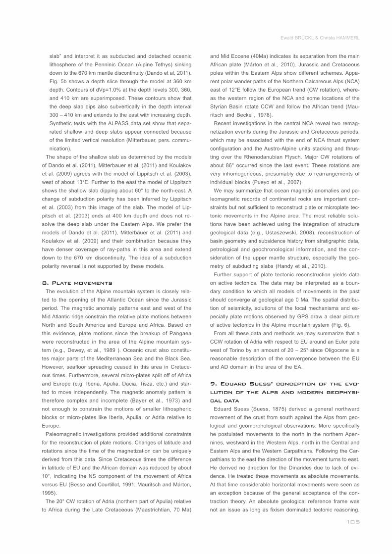
Figure 7: Asymmetric pattern at destructive plate boundaries. (a) contours of Alpine slab(s) (dVp = 1.4 % and 1.6%), plate boundaries, major
faults and location of profiles 1 – 5 are superimposed on digital terrain model; profiles are N to S, except for profile 5; arrows point from lower to upper
plate; (b) surface elevation, Moho depth, and Bouguer anomaly (BA, BAC, see Fig. 4) along profiles 1 – 5; profiles are centred at plate boundaries;
grey bar highlights systematic offset of Bouguer gravity minimum from plate boundary.___________________________________________________
Modern magnetic and paleomagnetic evidence and the pat-
tern of active tectonics strongly support Eduard Suess’ obser-
vations in the Alpine mountain system. For the Himalayas
Eduard Suess postulated a general movement of Asia from
north to south against India. However, modern geophysical
and geodetic evidence is clear enough to allow for full accor-
dance in the scientific community that India moved and still
moves from the south against Asia and the Himalayas.
Thus, if we want to further apply Eduard Suess’ scheme of
crustal movements to modern geophysical data we must treat
them as relative movements and interpret the moving crustal
block (sensu Eduard Suess) as the upper plate of a collisio-
nal orogen. This transformation of Eduard Suess’ original
scheme to a plate tectonic reasoning can be applied success-
fully to the Himalayas, the Apennines, the Western and Cen-
tral Alps and the Carpathians. In the following we argue on
the base of modern geophysical data that Eduard Suess’ pos-
tulated movements define the upper plate along the whole
Alpine system.
We recognize a significant pattern concerning the course
and polarity of the convergent plate boundaries derived from
seismic data (Fig. 3) and the location of relative Bouguer gra-
vity lows (Fig. 4). The axes of the Bouguer gravity lows follow
roughly the course of the convergent plate boundaries, but
they are shifted to the side of the lower, subducting plate. In
order to make this systematic pattern clearer, we compiled
the topographic elevation, the Moho depth, and the Bouguer
anomalies along 5 profiles over the LG (Liguria)-AD (Adria),
AD-EU (Europe), PA (Pannonian domain)-EU, and AD-PA plate
boundaries (Fig. 7). The profiles run from the lower plate to
the upper plate and they are centered on the plate boundary.
Keeping the polarity of subduction shown on the Moho map
(Fig. 3), the Moho depth and the BA confirm the pattern iden-
tifiable in Figure 4. Profiles 1 – 4 show clear upward steps of
_____
the Moho from the lower to the upper plate. At profile 5 no
step could be identified, but the general asymmetric pattern of
the Moho depth profiles from the lower to the upper plate is
maintained. The minima of the Bouguer anomaly (BA) or the
Bouguer anomaly stripped of the density variations in the up-
per crust (BAC) are 25-45 km shifted to the lower plate along
the profiles 1, 2, 3, and 5 (Fig. 7). The shift of the BAC mini-
mum to the lower plate at profile 4 (EU-PA) is less, an issue
we will address later. As mentioned before, subduction pola-
rity is a matter of discussion in the area of profile 3, the area
of the Tauern Window. However, in this case we postulate sub-
duction of EU under AD along this section of the AD-EU plate
boundary. Without this, the otherwise systematic pattern of Mo-
ho depth and BA (or BAC) across the plate boundaries would
be destroyed. Keeping the subduction polarities as shown in
Figures 3, 4, 5, 7 they correspond completely to the crustal
movements observed by Eduard Suess (1875).
Subduction of lithospheric mantle of the lower plate below
the upper plate or subvertical down is not the only geodyna-
mic conception that explains the accommodation of ongoing
convergence after continent - continent collision. Ren et al.
(2012) propose a symmetrical down-welling of both European
and Adriatic mantle lithosphere due to a gravitational (Ray-
leigh-Taylor) instability (Houseman and Molnar, 1997). E. g.,
Lorinczi and Houseman (2009) applied this conception to the
near vertical and drop-shaped slab below the Vrancea area
in the Southeast Carpathians. They were able to explain the
present distribution of deformation and the extent of the seis-
mically active zone. Applying this conception to the Alps would
make the discussion about upper and lower plate obsolete and
we would lose the connection to the principle of uni-directio-
nality of mountain building introduced by Eduard Suess. In the
following, we therefore only consider the plate tectonic con-
ception of upper - lower plate and subduction and show if and
___________
erosion of the lower lithosphere and facilitate this process.
Eduard Suess addressed also the only exception of the di-
rection of crustal movement and the curvature of the Alpine
system mountain. This concerns the Eastern Alps near the
southern corner of the Bohemian Massif and the Vienna Ba-
sin. The convex side of the Alpine mountain range points to
the south in this section. This observation would indicate a
reversed direction of crustal movements and, according to our
interpretation of Eduard Suess’ conception, a subduction po-
larity reversal. However, Suess explained this situation as the
effect of the Bohemian Massif as a buttress. The crustal block
approaching from the south was diverted to the east and bent
around this buttress. Tensile stress was induced by this me-
chanism resulting in the generation of the Vienna Basin. We
may estimate Eduard Suess’ interpretation as a first step in
the conception of lateral tectonic extrusion (e.g. Ratschbacher
et al., 1991).
Extrusion of parts of the Eastern Alps to the east is still an
issue in tectonic interpretation of geophysical data. In our opin-
ion, the essential geophysical constraints on tectonic models
of the eastern Eastern Alps are as follows:
the geometry of the Moho fragmentation (Fig. 3), including
the existence of the triple junction and the new micro-plate
named the Pannonian domain;
the termination of the shallow slab near the triple junction;
no or only minor amounts of continental lower lithosphere
was subducted along the Alpine arc east of the triple junc-
tion and under the Western Carpathians after consumption
of the lithosphere of the Penninic Ocean by subduction.
A plate tectonic model of the lithospheric mantle to meet
these two constraints was proposed. The absence of shallow
_______________
______________________
__
Ewald BRÜCKL & Christa HAMMERL
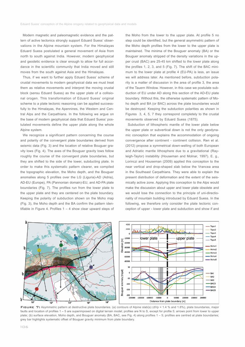
Figure 8: N-S oriented cross section through the lithosphere and
upper mantle at 13°E (profile 3 in Figure 7). Schematic geological pro-
file, crustal basement (red for Europe and yellow for Adria), tentative
LAB, and EU continental slab are superimposed on cross section
through the combined tomographic model of the upper mantle; arrows
highlight that the amount of thrust of Rhenodanubian Flysch and Aus-
tro-Alpine units over European basement agrees approximately with
the length of the subducted slab (~120 km)._____________________
how the observed structure of the East Alpine lithosphere and
slab can be explained by applying these principles.
Eduard Suess emphasized the arcuate alignment of moun-
tain ranges within orogenic systems. The concave sides of
the mountains’ arcs are oriented against the approaching
crustal blocks according to his observations. This means that
the concave sides of mountain arcs are generally oriented to-
ward the upper plate of subduction zones or collisional orogens.
This conception fits the situation in the Alpine system perfect-
ly. The subducting (shallow) slabs under the Central and Eas-
tern Alps form an arc with a radius of about 580 km (Fig. 7)
with the concave side pointing to the south, i. e. towards the
Adriatic plate. The ping pong ball model (e.g., Moores and
Twiss, 1995) explains the arcuate shape of trenches and sub-
ducting lithosphere by an analogy to a dent in a ping pong
ball. This analogy supports the interpretation that the concave
side of a subducting slab points toward the upper plate. The
ping pong model assumes further conservation of the area of
the subducting slab. The radius of the arc and the dip of the
slab are connected by a simple relation. A dip of 12° follows
from this relation for the shallow slab. Tomographic images re-
veal a near vertical dip of the shallow slab in the Central and
Eastern Alps. The consequence of this greater dip is lateral
tension. We may speculate that the partition of the slab into
apparently separate parts near the Brenner normal fault (~12°E)
is a consequence of this tension. However, we have to bear
in mind that geological factors initiating and accompanying
subduction and physical processes controlling the subduction
of a slab may be the dominant reasons for the partition.
Eduard Suess drew our attention to the one-sided nature of
Alpine mountain systems and related it to the direction of
crustal movements. Vergence of large folds and the dip of
major thrusts primarily follow this conception in the Eastern
Alps. However, Eduard Suess did not oversimplify, and he
admits that nature does not always follow generalized con-
ceptions in all details. This is the case for the Southern Alps,
where he describes geologic structures that indicate crustal
movements in the opposite direction. However, he interprets
these structures as features of secondary order (Suess, 1875).
Figure 8 shows a N-S oriented cross section through the
Eastern Alps at 13°E, which combines the results from the
TRANSALP and Alp01 profiles (Fig. 2) and the teleseismic up-
per mantle models (Fig. 5). The geophysical data demonstrate
the one-sided nature of this mountain range at a lithospheric
scale. The boundary between the Eastern and Southern Alps
(the PAL) at the surface almost coincides with the plate boun-
dary between AD and EU at Moho level. The thrust of Rheno-
danubian Flysch and Austro-Alpine units over EU basement
and Molasse amounts to about 120 km. Thrust faults in the
Southern Alps dip to the north and upper crustal shortening of
35 - 50 km has to be inferred (Castellarin et al., 2006). We spe-
culate that indentation and Adriatic lower crustal and lithos-
pheric thickening accommodates for this compression. Low P-
wave velocities (Figs. 5, 8) in the upper mantle under the
Southern Alps and the Adriatic foreland may support thermal
________
_____
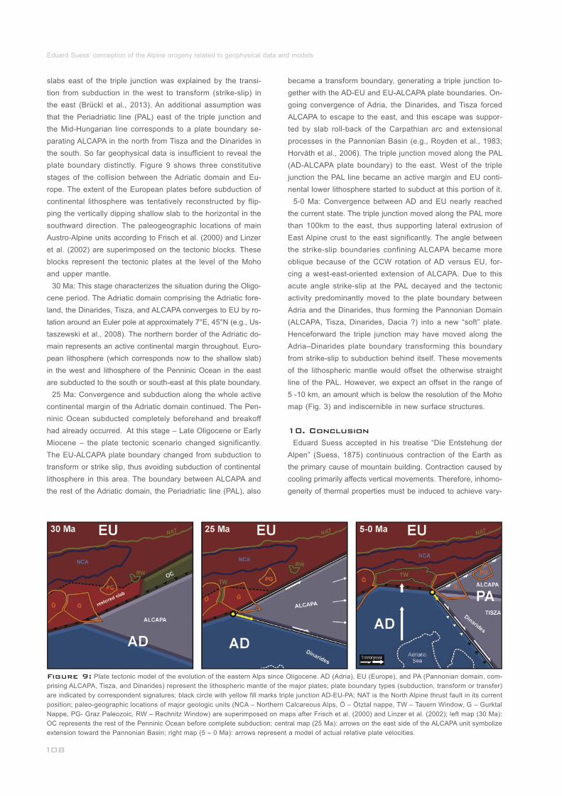
Eduard Suess’ conception of the Alpine orogeny related to geophysical data and models
Figure 9: Plate tectonic model of the evolution of the eastern Alps since Oligocene. AD (Adria), EU (Europe), and PA (Pannonian domain, com-
prising ALCAPA, Tisza, and Dinarides) represent the lithospheric mantle of the major plates; plate boundary types (subduction, transform or transfer)
are indicated by correspondent signatures; black circle with yellow fill marks triple junction AD-EU-PA; NAT is the North Alpine thrust fault in its current
position; paleo-geographic locations of major geologic units (NCA – Northern Calcareous Alps, Ö – Ötztal nappe, TW – Tauern Window, G – Gurktal
Nappe, PG- Graz Paleozoic, RW – Rechnitz Window) are superimposed on maps after Frisch et al. (2000) and Linzer et al. (2002); left map (30 Ma):
OC represents the rest of the Penninic Ocean before complete subduction; central map (25 Ma): arrows on the east side of the ALCAPA unit symbolize
extension toward the Pannonian Basin; right map (5 – 0 Ma): arrows represent a model of actual relative plate velocities._______________________
slabs east of the triple junction was explained by the transi-
tion from subduction in the west to transform (strike-slip) in
the east (Brückl et al., 2013). An additional assumption was
that the Periadriatic line (PAL) east of the triple junction and
the Mid-Hungarian line corresponds to a plate boundary se-
parating ALCAPA in the north from Tisza and the Dinarides in
the south. So far geophysical data is insufficient to reveal the
plate boundary distinctly. Figure 9 shows three constitutive
stages of the collision between the Adriatic domain and Eu-
rope. The extent of the European plates before subduction of
continental lithosphere was tentatively reconstructed by flip-
ping the vertically dipping shallow slab to the horizontal in the
southward direction. The paleogeographic locations of main
Austro-Alpine units according to Frisch et al. (2000) and Linzer
et al. (2002) are superimposed on the tectonic blocks. These
blocks represent the tectonic plates at the level of the Moho
and upper mantle.
30 Ma: This stage characterizes the situation during the Oligo-
cene period. The Adriatic domain comprising the Adriatic fore-
land, the Dinarides, Tisza, and ALCAPA converges to EU by ro-
tation around an Euler pole at approximately 7°E, 45°N (e.g., Us-
taszewski et al., 2008). The northern border of the Adriatic do-
main represents an active continental margin throughout. Euro-
pean lithosphere (which corresponds now to the shallow slab)
in the west and lithosphere of the Penninic Ocean in the east
are subducted to the south or south-east at this plate boundary.
25 Ma: Convergence and subduction along the whole active
continental margin of the Adriatic domain continued. The Pen-
ninic Ocean subducted completely beforehand and breakoff
had already occurred. At this stage – Late Oligocene or Early
Miocene – the plate tectonic scenario changed significantly.
The EU-ALCAPA plate boundary changed from subduction to
transform or strike slip, thus avoiding subduction of continental
lithosphere in this area. The boundary between ALCAPA and
the rest of the Adriatic domain, the Periadriatic line (PAL), also
___________________________________
became a transform boundary, generating a triple junction to-
gether with the AD-EU and EU-ALCAPA plate boundaries. On-
going convergence of Adria, the Dinarides, and Tisza forced
ALCAPA to escape to the east, and this escape was suppor-
ted by slab roll-back of the Carpathian arc and extensional
processes in the Pannonian Basin (e.g., Royden et al., 1983;
Horváth et al., 2006). The triple junction moved along the PAL
(AD-ALCAPA plate boundary) to the east. West of the triple
junction the PAL line became an active margin and EU conti-
nental lower lithosphere started to subduct at this portion of it.
5-0 Ma: Convergence between AD and EU nearly reached
the current state. The triple junction moved along the PAL more
than 100km to the east, thus supporting lateral extrusion of
East Alpine crust to the east significantly. The angle between
the strike-slip boundaries confining ALCAPA became more
oblique because of the CCW rotation of AD versus EU, for-
cing a west-east-oriented extension of ALCAPA. Due to this
acute angle strike-slip at the PAL decayed and the tectonic
activity predominantly moved to the plate boundary between
Adria and the Dinarides, thus forming the Pannonian Domain
(ALCAPA, Tisza, Dinarides, Dacia ?) into a new “soft” plate.
Henceforward the triple junction may have moved along the
Adria–Dinarides plate boundary transforming this boundary
from strike-slip to subduction behind itself. These movements
of the lithospheric mantle would offset the otherwise straight
line of the PAL. However, we expect an offset in the range of
5 -10 km, an amount which is below the resolution of the Moho
map (Fig. 3) and indiscernible in new surface structures.
Eduard Suess accepted in his treatise “Die Entstehung der
Alpen” (Suess, 1875) continuous contraction of the Earth as
the primary cause of mountain building. Contraction caused by
cooling primarily affects vertical movements. Therefore, inhomo-
geneity of thermal properties must be induced to achieve vary-
____
10. Conclusion
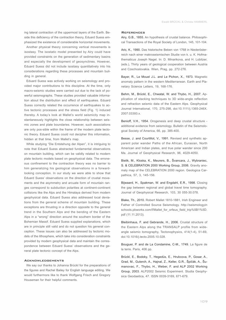
Ewald BRÜCKL & Christa HAMMERL
ing lateral contraction of the uppermost layers of the Earth. Be-
side this deficiency of the contraction theory, Eduard Suess em-
phasized the existence of considerable horizontal movements.
Another physical theory concerning vertical movements is
isostasy. The isostatic model presented by Airy could have
provided constraints on the generation of sedimentary basins
and especially the development of geosynclines. However,
Eduard Suess did not include isostasy quantitatively into his
considerations regarding these processes and mountain buil-
ding in general.
Eduard Suess was actively working on seismology and pro-
vided major contributions to this discipline. At the time, only
macro-seismic studies were carried out due to the lack of po-
werful seismographs. These studies provided valuable informa-
tion about the distribution and effect of earthquakes. Eduard
Suess correctly related the occurrence of earthquakes to ac-
tive tectonic processes and the stress field (Fig. 1) induced
thereby. A today’s look at Mallet’s world seismicity map in-
stantaneously highlights the close relationship between seis-
mic zones and plate boundaries. However, such associations
are only pos-sible within the frame of the modern plate tecto-
nic theory. Eduard Suess could not decipher this information,
hidden at that time, from Mallet’s map.
While studying “Die Entstehung der Alpen”, it is intriguing to
note that Eduard Suess abstracted fundamental observations
on mountain building, which can be validly related to modern
plate tectonic models based on geophysical data. The errone-
ous confinement to the contraction theory was no barrier to
him generalizing his geological observations in a forward-
looking conception. In our study we were able to show that
Eduard Suess’ observations on the direction of crustal move-
ments and the asymmetry and arcuate form of mountain ran-
ges correspond to subduction polarities at continent-continent
collisions like the Alps and the Himalaya derived from modern
geophysical data. Eduard Suess also addressed local devia-
tions from the general scheme of mountain building. These
exceptions are thrusting in a direction opposite to the general
trend in the Southern Alps and the bending of the Eastern
Alps in a “wrong” direction around the southern border of the
Bohemian Massif. Eduard Suess supplied explanations, which
are in principle still valid and do not question his general con-
ception. These issues can also be addressed by tectonic mo-
dels of the lithosphere, which take into consideration constraints
provided by modern geophysical data and maintain the corres-
pondence between Eduard Suess’ observations and the ge-
neral plate tectonic concept of the Alps.
We say our thanks to Johanna Brückl for the preparations of
the figures and Rachel Bailey for English language editing. We
would furthermore like to thank Wolfgang Frisch and Gregory
Houseman for their helpful comments.
_____________________________________
__________________
__________________
___________________
Acknowledgements
References
Airy, G.B., 1855.
Aric, K., 1990.
Bayer, R., Le Mouel J.L. and Le Pichon, X., 1973.
Behm, M., Brückl, E., Chwatal, W. and Thybo, H., 2007.
Benioff, V.H., 1954.
Besse, J. and Courtillot, V., 1991.
Bielik, M., Kloska, K., Meurers, B., Švancara, J., Wybraniec,
S. & CELEBRATION 2000 Working Group, 2006.
Bijwaard, H., Spakman, W. and Engdahl, E.R., 1998.
Blake, Th., 2010.
Bleibinhaus, F. and Gebrande, H., 2006.
Bouguer, P. and de La Condamine, C-M., 1749.
Brückl, E., Bodoky, T., Hegedüs, E., Hrubcova, P., Gosar, A.,
Grad, M., Guterch, A., Hajnal, Z., Keller, G.R., Špičák, A., Šu-
manovac, F., Thybo, H., Weber, F. and ALP 2002 Working
Group, 2003.
An hypothesis of crustal balance. Philosophi-
cal Transactions of the Royal Society of London, 145, 101-104.
Das historische Beben von 1768 in Niederöster-
reich nach einer makroseismischen Studie von k. u. K. Hofma-
thematicus Joseph Nagel. In: D. Minarikova, and H. Lobitzer,
(eds.), Thirty years of geological cooperation between Austria
and Czechoslovakia. Wien, Prag, pp. 272-276.
Magnetic
anomaly pattern in the western Mediterranean. Earth and Pla-
netary Science Letters, 19, 168-176.
Ap-
plication of stacking techniques to 3D wide-angle reflection
and refraction seismic data of the Eastern Alps. Geophysical
Journal International, 170, 275-298, doi:10.1111/j.1365-246X.
2007.03393.x.
Orogenesis and deep crustal structure -
additional evidence from seismology. Bulletin of the Seismolo-
gical Society of America, 66, pp. 385-400.
Revised and synthetic ap-
parent polar wander Paths of the African, Eurasian, North
American and Indian plates, and true polar wander since 200
Ma. Journal of Geophysical Research, 96, 4029-4050.
Gravity ano-
maly map of the CELEBRATION 2000 region. Geologica Car-
pathica, 57, 3, 145-156.
Closing
the gap between regional and global travel time tomography.
Journal of Geophysical Research, 103, 30 055-30.078.
Robert Mallet 1810-1881, Irish Engineer and
Father of Controlled Source Seismology. http://seismologyin
schools.pbworks.com/f/Mallet_for_orfeus_field_trip%5B1%5D.
pdf (11.11.2013).
Crustal structure of
the Eastern Alps along the TRANSALP profile from wide-
angle seismic tomography, Tectonophysics, 414(1-4), 51-69,
doi:10.1016/j.tecto.2005.10.028.
La figure de
la terre. Paris, 406 pp.
ALP2002 Seismic Experiment. Studia Geophy-
sica Geodaetica, 47. ISSN 0039-3169, 671-679.
____________
____________________
________________
_____
______________________________
_____
________________________
___________
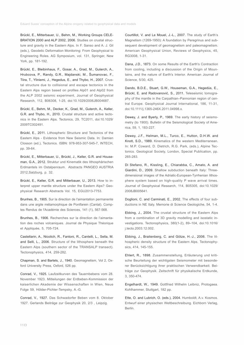
Eduard Suess’ conception of the Alpine orogeny related to geophysical data and models
Courtillot, V. and Le Mouel, J.-L., 2007.
Dana, J.D., 1873.
Dando, B.D.E., Stuart, G.W., Houseman, G.A., Hegedüs, E.,
Brückl, E. and Radovanović, S., 2011.
Dewey, J. and Byerly, P., 1969.
Dewey, J.F., Helman, M.L., Turco, E., Hutton, D.H.W. and
Knott, S.D., 1989.
Di Stefano, R., Kissling, E., Chiarabba, C., Amato, A. and
Giardini, D., 2009.
Doglioni, C. and Carminati, E., 2002.
Ebbing, J., 2004.
Ebbing, J., Braitenberg, C. and Götze, H.-J., 2006.
Ehlert, R., 1898.
Engelhardt, W., 1949.
Ette, O. and Lubrich, O. (eds.), 2004.
The study of Earth’s
Magnetism (1269-1950): A foundation by Peregrinus and sub-
sequent development of geomagnetism and paleomagnetism.
American Geophysical Union, Reviews of Geophysics, 45,
RG3008, 1-31.
On some Results of the Earth's Contraction
from cooling, including a discussion of the Origin of Moun-
tains, and the nature of Earth's Interior. American Journal of
Science, 5/30, 425.
Teleseismic tomogra-
phy of the mantle in the Carpathian–Pannonian region of cen-
tral Europe. Geophysical Journal International, 186, 11-31,
doi:10.1111/j.1365-246X.2011.04998.x.
The early history of seismo-
metry (to 1900). Bulletin of the Seismological Society of Ame-
rica, 59, 1, 183-227.
Kinematics of the western Mediterranean.
In: M.P. Coward, D. Dietrich, R.G. Park, (eds.), Alpine Tec-
tonics. Geological Society, London, Special Publication, pp.
265-283.
Shallow subduction beneath Italy: Three-
dimensional images of the Adriatic-European-Tyrrhenian lithos-
phere system based on high-quality P wave arrival times.
Journal of Geophysical Research, 114, B05305, doi:10.1029/
2008JB005641.
The effects of four sub-
ductions in NE Italy. Memorie di Science Geologiche, 54, 1-4.
The crustal structure of the Eastern Alps
from a combination of 3D gravity modelling and isostatic in-
vestigations. Tectonophysics, 380(1-2), 89–104, doi:10.1016/
j.tecto.2003.12.002.
The lit-
hospheric density structure of the Eastern Alps. Tectonophy-
sics, 414, 145-155.
Zusammenstellung, Erläuterung und kriti-
sche Beurteilung der wichtigsten Seismometer mit besonde-
rer Berücksichtigung ihrer praktischen Verwendbarkeit. Bei-
träge zur Geophysik. Zeitschrift für physikalische Erdkunde,
3, 350-474.
Gottfried Wilhelm Leibniz, Protogaea.
Kohlhammer, Stuttgart, 182 pp.
Humboldt, A.v. Kosmos.
Entwurf einer physischen Weltbeschreibung. Eichborn Verlag,
Berlin.
Brückl, E., Mitterbauer, U., Behm, M., Working Groups CELE-
BRATION 2000 and ALP 2002, 2006.
Brückl, E., Bleibinhaus, F., Gosar, A., Grad, M., Guterch, A.,
Hrubcova, P., Randy, G.R., Majdanski, M., Šumanovac, F.,
Tiira, T., Yliniemi, J., Hegedus, E., and Thybo, H., 2007.
Brückl, E., Behm, M., Decker, K., Grad, M., Guterch, A., Keller,
G.R. and Thybo, H., 2010.
Brückl, E., 2011.
Brückl, E., Mitterbauer, U., Brückl, J., Keller, G.R. and House-
man, G.A., 2012.
Brückl, E., Keller, G.R. and Mitterbauer, U., 2013.
Brunhes, B., 1905.
Brunhes, B., 1906.
Castellarin, A., Nicolich, R., Fantoni, R., Cantelli, L., Sella, M.
and Selli, L., 2006.
Chapman, S. and Bartels, J., 1940.
Conrad, V., 1925.
Conrad, V., 1927.
Studies on crustal struc-
ture and gravity in the Eastern Alps. In F. Sanso and A. J. Gil
(eds.), Geodetic Deformation Monitoring: From Geophysical to
Engineering Roles. AG Symposium, vol. 131, Springer, New
York, pp. 181-192.
Crus-
tal structure due to collisional and escape tectonics in the
Eastern Alps region based on profiles Alp01 and Alp02 from
the ALP 2002 seismic experiment, Journal of Geophysical
Research, 112, B06308, 1-25, doi:10.1029/2006JB004687.
Crustal structure and active tecto-
nics in the Eastern Alps. Tectonics, 29, TC2011, doi:10.1029/
2009TC002491.
Lithospheric Structure and Tectonics of the
Eastern Alps - Evidence from New Seismic Data. In: Damien
Closson (ed.), Tectonics. ISBN: 978-953-307-545-7, INTECH,
pp. 39-64.
Struktur und Kinematik des lithosphärischen
Erdmantels im Ostalpenraum. Abstracts PANGEO AUSTRIA
2012,Salzburg, p. 32.
How to in-
terpret upper mantle structure under the Eastern Alps? Geo-
physical Research Abstracts Vol. 15, EGU2013-7753.
Sur la direction de l'aimantation permanente
dans une argile métamorphique de Pontfarein (Cantal). Comp-
tes Rendus de l'Académie des Sciences, 141 (1), 567-568.
Recherches sur la direction de l’aimanta-
tion des roches volcaniques. Journal de Physique Théorique
et Appliquée, 5, 705-724.
Structure of the lithosphere beneath the
Eastern Alps (southern sector of the TRANSALP transect).
Tectonophysics, 414, 259-282.
Geomagnetism, Vol 2, Ox-
ford University Press, Oxford, 526 pp.
Laufzeitkurven des Tauernbebens vom 28.
November 1923. Mitteilungen der Erdbeben-Kommission der
kaiserlichen Akademie der Wissenschaften in Wien, Neue
Folge 59, Hölder-Pichler-Tempsky, A.-G.
Das Schwadorfer Beben vom 8. Oktober
1927. Gerlands Beiträge zur Geophysik 20, 2/3 , Leipzig.
__
________________________________
______
___
_____________________________
_________________________
____________________
_________________
___
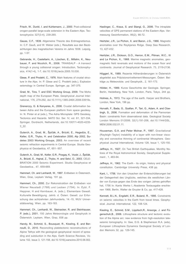
Ewald BRÜCKL & Christa HAMMERL
Frisch, W., Dunkl, I. and Kuhlemann, J., 2000.
Gauss, C.F., 1839.
Gebrande, H., Castellarin, A., Lüschen, E., Millahn, K., Neu-
bauer, F. and Nicolich, R., 2006.
Giese, P. and Prodehl, C., 1976.
Grad, M., Tiira, T. and ESC Working Group, 2009.
Grenerczy, G. & Kenyeres, A., 2006.
Guterch, A., Grad, M., Špičák, A., Brückl, E., Hegedüs, E.,
Keller, G.R., Thybo, H. and Celebration 2000, Alp 2002, Su-
detes 2003 Working Groups, 2003.
Guterch, A., Grad, M., Keller, G.R., Posgay, K., Vozár, J., Špičák,
A., Brückl, E., Hajnal, Z., Thybo, H. and Selvi, O., 2003.
Hammerl, Ch. and Lenhardt, W., 1997.
Hammerl, Ch., 2000.
Hammerl, Ch., Lenhardt, W., Steinacker, R. and Steinhauser,
P. (eds.), 2001.
Handy, M., Schmid, S., Bousquet, R., Kissling, E. and Ber-
noulli, D., 2010.
Post-collisional
orogen-parallel large-scale extension in the Eastern Alps. Tec-
tonophysics 327(3-4), 239-265.
Allgemeine Theorie des Erdmagnetismus.
In: C.F. Gauß, and W. Weber (eds.), Resultate aus den Beob-
achtungen des magnetischen Vereins im Jahre 1838. Leipzig,
pp. 1-57.
TRANSALP - A transect
through a young collisional orogen: Introduction, Tectonophy-
sics, 414(1-4), 1-7, doi:10.1016/j.tecto.2005.10.030.
Main features of crustal struc-
ture in the Alps. In: P. Giese and C. Prodehl (eds.), Explosion
seismology in Central Europe. Springer, pp. 347-375.
The Moho
depth map of the European Plate. Geophysical Journal Inter-
national, 176, 279-292, doi:10.1111/j.1365-246X.2008.03919x.
Crustal deformation be-
tween Adria and the European platform from space geodesy.
In: N. Pinter et al (eds.), The Adria Microplate: GPS Geodesy,
Tectonics and Hazards. NATO Sci. Ser. IV, vol. 61, 321-334,
Springer, Dordrecht, Netherlands, doi:10.1007/1-4020-4235-
3_22.
An overview of recent
seismic refraction experiments in Central Europe. Studia Geo-
physica et Geodaetica, 47, 651- 657.
CELE-
BRATION 2000 Seismic Experiment. Studia Geophysica et
Geodaetica., 47, 659-669.
Erdbeben in Österreich.
Wien, Graz, Leykam Verlag, 191 pp.
Zur Rekonstruktion der Erdbeben von
Wiener Neustadt (1768) und Leoben (1794). In: Eybl, F.
Heppner, H and Kernbauer, A. (eds.), Elementare Gewalt.
Kulturelle Bewältigung. Jahrb. d. Österr. Gesell. zur Erfor-
schung des achtzehnten Jahrhunderts, 14.-15, WUV Univer-
sitätsverlag, Wien, pp. 163-183.
150 Jahre Meteorologie und Geophysik in
Österreich. Leykam, Wien, Graz, 838 pp.
Reconciling platetectonic reconstructions of
Alpine Tethys with the geological–geophysical record of sprea-
ding and subduction in the Alps. Earth Science Reviews, Vo-
lume 102, Issue 3, 121-158, doi:10.1016/j.earscirev.2010.06.002.
________________________
________
_______
____________________
____________________________
____________________
_______________________
________________
Haslinger, C., Kraus, S. and Stangl, G., 2006.
Heirtzler, J.R., Le Pichon, X. and Baron, J.G., 1966.
Heirtzler, J.R., Dickson, G.O., Herron, E.M., Pitman, W.C., III
and Le Pichon, X., 1968.
Höggerl, N., 1989.
Hölder, H., 1989.
Holmes, A., 1913.
Horvath, F., Bada, G., Szafian, P., Tari, G., Adam, A. and Cloe-
tingh, S., 2006.
Houseman, G.A. and Peter Molnar, P., 1997.
Jeffreys, H., 1927.
Jeffreys, H., 1962.
Kant, I., 1756.
Kennett, B.L.N., Engdahl, E.R., Buland, R., 1995.
Kissling, E., Schmid, S.M., Lippitsch,R., Ansorge, J. and Fü-
genschuh,B., 2006.
The intraplate
velocities of GPS permanent stations of the Eastern Alps. Ver-
messung Geoinformation, 95(2), 66-72.
Magnetic
anomalies over the Reykjanes Ridge. Deep Sea Research,
13, 427-432.
Marine magnetic anomalies, geo-
magnetic field reversals and motions of the ocean floor and
continents. Journal of Geophysical Research. 73, 2119-2136.
Rezente Höhenänderungen in Österreich
abgeleitet aus Präzisionsnivellement-Messungen, Österr. Bei-
träge zu Meteoroloie. und Geophysik., 2, 161-173.
Kurze Geschichte der Geologie. Springer,
Berlin, Heidelberg, New York, London, Paris, Tokyo, 244 pp.
The age of the earth. Harper and Brothers,
London, New York, 196 pp.
Formation and deformation of the Pannonian
Basin: constraints from observational data. Geological Society
London Memoirs 01/2006; 32(1):191-206, doi:10.1144/GSL.
MEM.2006.032.01.11.
Gravitational
(Rayleigh–Taylor) instability of a layer with non-linear visco-
sity and convective thinning of continental lithosphere. Geo-
physical Journal International, Volume 128, Issue 1, 125-150.
On Two British Earthquakes. Monthly No-
tices of the Royal Astronomical Society, Geophysical Supple-
ment , 1, 483-94.
The Earth - its origin, history and physical
constitution. Cambridge University Press, 438 pp.
Von den Ursachen der Erderschütterungen bei
der Gelegenheit des Unglücks, welches die westlichen Län-
der von Europa gegen das Ende des vorigen Jahres getroffen
hat, 1756 In: Kants Werke I, Akademie Textausgabe erschie-
nen 1968, Berlin, Walter de Gruyter & Co, pp. 417-428.
Constraints
on seismic velocities in the Earth from travel times. Geophy-
sical. Journal. International, 122, 108-124.
Lithosphere structure and tectonic evolu-
tion of the Alpine arc: new evidence from high-resolution tele-
seismic tomography. In: Gee, D.G. & Stephenson R.A. (eds),
European Lithosphere Dynamics Geological Society of Lon-
don Memoirs 32, pp. 129-145.
__________________
_________
_________
_____
________________
_________________________
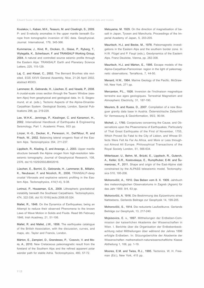
Eduard Suess’ conception of the Alpine orogeny related to geophysical data and models
Matuyama, M. 1929.
Mauritsch, H.J. and Becke, M., 1978.
Mauritsch, H.J. and Márton, E., 1995.
Menard, H.W., 1964.
Mercanton, P.L., 1926.
Meurers, B. and Ruess, D., 2007.
Michell, J., 1760.
Mitterbauer, U., Behm, M., Brückl, E., Lippitsch, R., Guterch,
A., Keller, G.R., Koslovskaya, E., Rumpfhuber, E-M. and Šu-
manovac, F., 2011.
Mohorovičić, A., 1910. Das Beben vom 8. X. 1909.
Mohorovičić, A. 1916.
Mohorovičić, S., 1914.
Mojsisovics, E. v., 1897.
Moores, E.M. and Twiss, R.J., 1995.
On the direction of magnetisation of ba-
salt in Japan, Tyosen and Manchuria. Proceedings of the Im-
perial Academy of Japan, 5, 203-205.
Paleomagnetic investi-
gations in the Eastern Alps and the southern border zone. In
H.W. Flügel and P. Faupl (eds.), Geodynamics of the Eastern
Alps. Franz Deuticke, Vienna, pp. 282-308.
Escape models of the
Alpine-Carpathian-Pannoninan region in the light of paleomag-
netic observations. TerraNova, 7, 44-50.
Marine Geology of the Pacific. McGraw-
hill, New York, 271 pp.
Inversion de l'inclinaison magnetique
terrestre aux ages geologiques. Terrestrial Magnetism and
Atmospheric Electricity, 31, 187-190.
Compilation of a new Bou-
guer gravity data base in Austria. Österreichische Zeitschrift
für Vermessung & Geoinformation, 95/2, 90-94.
Conjectures concerning the Cause, and Ob-
servations upon the Phaenomena of Earthquakes; Particularly
of That Great Earthquake of the First of November, 1755,
Which Proved So Fatal to the City of Lisbon, and Whose Ef-
fects Were Felt As Far As Africa, and More or Less through-
out Almost All Europe. Philosophical Transactions of the
Royal Society London, 51, 566-634.
Shape and origin of the East-Alpine slab
constrained by the ALPASS teleseismic model. Tectonophy-
sics 510, 195-206.
Jahrbuch
des meteorologischen Observatoriums in Zagreb (Agram) für
das Jahr 1909. 9/4, 63 pp.
Die Bestimmung des Epizentrums eines
Nahbebens. Gerlands Beitrage zur Geophysik 14, 199-205.
Die reduzierte Laufzeitkurve. Gerlands
Beiträge zur Geophysik, 13, 217-240.
Mittheilungen der Erdbeben-Com-
mission der kaiserlichen Akademie der Wissenschaften in
Wien. I. Berichte über die Organisation der Erdbebenbeob-
achtung nebst Mittheilungen über während der Jahres 1896
erfolgte Erdbeben. In: Sitzungsberichte der Akademie der
Wissenschaften mathematisch-naturwissenschaftliche Klasse
Abtheilung 1, 106, pp. 1-19.
Tectonics. W. H. Free-
man (Ed.), New York, 415 pp.
___________________
_______________
_________________
____________________
___________
____________________
__
_________________________
Koulakov, I., Kaban, M.K., Tesauro, M. and Cloetingh, S., 2009.
Kummerow, J., Kind, R., Oncken, O., Giese, P., Ryberg, T.,
Wylegalla, K., Scherbaum, F. and TRANSALP Working Group,
2004.
Laj, C. and Kissel, C., 2002.
Lammerer, B., Gebrande, H., Lüschen, E. and Veselá, P., 2008.
Lee, W.H.K., Jennings, P., Kisslinger, C. and Kanamori, H.,
2002.
Linzer, H.-G., Decker, K., Peresson, H., Dell'Mour, R. and
Frisch, W., 2002.
Lippitsch, R., Kissling, E. and Ansorge, J., 2003.
Lüschen, E., Borrini, D., Gebrande, H., Lammerer, B., Millahn,
K., Neubauer, F. and Nicolich, R., 2006.
Lorinczi, P., Houseman, G.A., 2009.
Mallet, R., 1848.
Mallet, R. and Mallet, J.W., 1858.
Márton, E., Zampieri, D., Grandesso, P., ´Cosovic, V. and Mo-
ro, A., 2010.
P- and S-velocity anomalies in the upper mantle beneath Eu-
rope from tomographic inversion of ISC data. Geophysical.
Journal. International, 179, 345-366.
A natural and controlled source seismic profile through
the Eastern Alps: TRANSALP. Earth and Planetary Science
Letters, 225, 115-129.
The Bernard Brunhes site revi-
sited. EGS XXVII General Assembly, Nice, 21-26 April 2002,
abstract #5303.
A crustal-scale cross section through the Tauern Window (eas-
tern Alps) from geophysical and geological data. In: S. Sieges-
mund, et al. (eds.), Tectonic Aspects of the Alpine-Dinaride-
Carpathian System. Geological Society, London, Special Pub-
lications 298, pp. 219-229.
International Handbook of Earthquake & Engineering
Seismology, Part 1. Academic Press, 933 pp.
Balancing lateral orogenic float of the Eas-
tern Alps. Tectonophysics 354, 211-237.
Upper mantle
structure beneath the Alpine orogen from high-resolution tele-
seismic tomography. Journal of Geophysical Research, 108,
2376, doi:10.1029/2002JB002016.
TRANSALP-deep
crustal Vibroseis and explosive seismic profiling in the Eas-
tern Alps. Tectonophysics, 414(1-4), 9-38.
Lithospheric gravitational
instability beneath the Southeast Carpathians. Tectonophysics,
474, 322-336, doi:10.1016/j.tecto.2008.05.024.
On the Dynamics of Earthquakes; being an
Attempt to reduce their observed Phenomena to the known
Laws of Wave Motion in Solids and Fluids. Read 9th February
1846, Irish Acadmey, 21, 51-106.
The earthquake catalogue
of the British Association, with the discussion, curves, and
maps, etc. Taylor and Francis, London.
New Cretaceous paleomagnetic result from the
foreland of the Southern Alps and the refined apparent polar
wander path for stable Adria. Tectonophysics, 480, 57-72.
____________________
____________
_________________
________________
_______________________
__________________
___
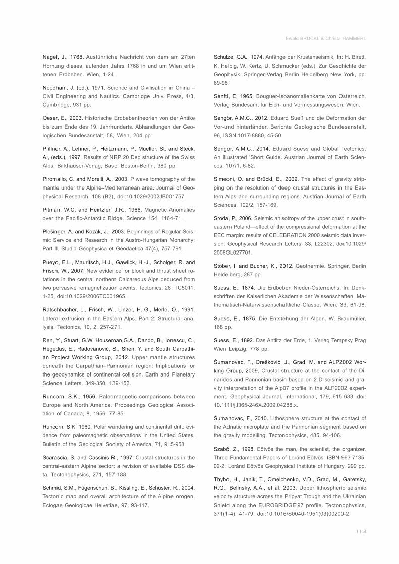
Ewald BRÜCKL & Christa HAMMERL
Nagel, J., 1768.
Needham, J. (ed.), 1971.
Oeser, E., 2003.
Pfiffner, A., Lehner, P., Heitzmann, P., Mueller, St. and Steck,
A., (eds.), 1997.
Piromallo, C. and Morelli, A., 2003.
Pitman, W.C. and Heirtzler, J.R., 1966.
Plešinger, A. and Kozák, J., 2003.
Pueyo, E.L., Mauritsch, H.J., Gawlick, H.-J., Scholger, R. and
Frisch, W., 2007.
Ratschbacher, L., Frisch, W., Linzer, H.-G., Merle, O., 1991.
Ren, Y., Stuart, G.W. Houseman,G.A., Dando, B., Ionescu, C.,
Hegedüs, E., Radovanović, S., Shen, Y. and South Carpathi-
an Project Working Group, 2012.
Runcorn, S.K., 1956.
Runcorn, S.K. 1960.
Scarascia, S. and Cassinis R., 1997.
Schmid, S.M., Fügenschuh, B., Kissling, E., Schuster, R., 2004.
Ausführliche Nachricht von dem am 27ten
Hornung dieses laufenden Jahrs 1768 in und um Wien erlit-
tenen Erdbeben. Wien, 1-24.
Science and Civilisation in China –
Civil Engineering and Nautics. Cambridge Univ. Press, 4/3,
Cambridge, 931 pp.
Historische Erdbebentheorien von der Antike
bis zum Ende des 19. Jahrhunderts. Abhandlungen der Geo-
logischen Bundesanstalt, 58, Wien, 204 pp.
Results of NRP 20 Dep structure of the Swiss
Alps. Birkhäuser-Verlag, Basel Boston-Berlin, 380 pp.
P wave tomography of the
mantle under the Alpine–Mediterranean area. Journal of Geo-
physical Research. 108 (B2), doi:10.1029/2002JB001757.
Magnetic Anomalies
over the Pacific-Antarctic Ridge. Science 154, 1164-71.
Beginnings of Regular Seis-
mic Service and Research in the Austro-Hungarian Monarchy:
Part II. Studia Geophysica et Geodaetica 47(4), 757-791.
New evidence for block and thrust sheet ro-
tations in the central northern Calcareous Alps deduced from
two pervasive remagnetization events. Tectonics, 26, TC5011,
1-25, doi:10.1029/2006TC001965.
Lateral extrusion in the Eastern Alps. Part 2: Structural ana-
lysis. Tectonics, 10, 2, 257-271.
Upper mantle structures
beneath the Carpathian–Pannonian region: Implications for
the geodynamics of continental collision. Earth and Planetary
Science Letters, 349-350, 139-152.
Paleomagnetic comparisons between
Europe and North America. Proceedings Geological Associ-
ation of Canada, 8, 1956, 77-85.
Polar wandering and continental drift: evi-
dence from paleomagnetic observations in the United States,
Bulletin of the Geological Society of America, 71, 915-958.
Crustal structures in the
central-eastern Alpine sector: a revision of available DSS da-
ta. Tectonophysics, 271, 157-188.
Tectonic map and overall architecture of the Alpine orogen.
Eclogae Geologicae Helvetiae, 97, 93-117.
__________________________
______________
______
___
____
____
________________________
_____________________
_______________________
___
______________________
_______________
Schulze, G.A., 1974.
Senftl, E, 1965.
Sengör, A.M.C., 2012.
Sengör, A.M.C., 2014.
Simeoni, O. and Brückl, E., 2009.
Sroda, P., 2006.
Stober, I. and Bucher, K., 2012.
Suess, E., 1874.
Suess, E., 1875.
Suess, E., 1892.
Šumanovac, F., Orešković, J., Grad, M. and ALP2002 Wor-
king Group, 2009.
Šumanovac, F., 2010.
Szabó, Z., 1998.
Thybo, H., Janik, T., Omelchenko, V.D., Grad, M., Garetsky,
R.G., Belinsky, A.A., et al. 2003.
Anfänge der Krustenseismik. In: H. Birett,
K. Helbig, W. Kertz, U. Schmucker (eds.), Zur Geschichte der
Geophysik. Springer-Verlag Berlin Heidelberg New York, pp.
89-98.
Bouguer-Isoanomalienkarte von Österreich.
Verlag Bundesamt für Eich- und Vermessungswesen, Wien.
Eduard Sueß und die Deformation der
Vor-und hinterländer. Berichte Geologische Bundesanstalt,
96, ISSN 1017-8880, 45-50.
Eduard Suess and Global Tectonics:
An illustrated 'Short Guide. Austrian Journal of Earth Scien-
ces, 107/1, 6-82.
The effect of gravity strip-
ping on the resolution of deep crustal structures in the Eas-
tern Alps and surrounding regions. Austrian Journal of Earth
Sciences, 102/2, 157-169.
Seismic anisotropy of the upper crust in south-
eastern Poland—effect of the compressional deformation at the
EEC margin: results of CELEBRATION 2000 seismic data inver-
sion. Geophysical Research Letters, 33, L22302, doi:10.1029/
2006GL027701.
Geothermie. Springer, Berlin
Heidelberg, 287 pp.
Die Erdbeben Nieder-Österreichs. In: Denk-
schriften der Kaiserlichen Akademie der Wissenschaften, Ma-
thematisch-Naturwissenschaftliche Classe, Wien, 33, 61-98.
Die Entstehung der Alpen. W. Braumüller,
168 pp.
Das Antlitz der Erde, 1. Verlag Tempsky Prag
Wien Leipzig, 778 pp.
Crustal structure at the contact of the Di-
narides and Pannonian basin based on 2-D seismic and gra-
vity interpretation of the Alp07 profile in the ALP2002 experi-
ment. Geophysical Journal. International, 179, 615-633, doi:
10.1111/j.l365-246X.2009.04288.x.
Lithosphere structure at the contact of
the Adriatic microplate and the Pannonian segment based on
the gravity modelling. Tectonophysics, 485, 94-106.
Eötvös the man, the scientist, the organizer.
Three Fundamental Papers of Loránd Eötvös. ISBN 963-7135-
02-2. Loránd Eötvös Geophysical Institute of Hungary, 299 pp.
Upper lithospheric seismic
velocity structure across the Pripyat Trough and the Ukrainian
Shield along the EUROBRIDGE'97 profile. Tectonophysics,
371(1-4), 41-79, doi:10.1016/S0040-1951(03)00200-2.
_
________________________________
________
_____
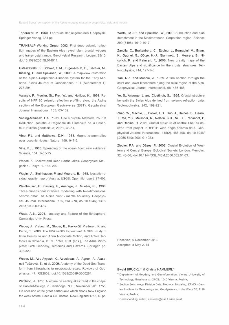
Eduard Suess’ conception of the Alpine orogeny related to geophysical data and models
Wortel, M.J.R. and Spakman, W., 2000.
Zanolla, C., Braitenberg, C., Ebbing, J., Bernabini, M., Bram,
K., Gabriel, G., Götze, H.-J., Giammetti, S., Meurers, B., Ni-
colich, R. and Palmieri, F., 2006.
Yan, Q.Z. and Mechie, J., 1989.
Ye, S., Ansorge, J. and Cloetingh, S., 1995.
Zhao, W., Mechie, J., Brown, L.D., Guo, J., Haines, S., Hearn,
T., Ma, Y.S., Meissner, R., Nelson, K.D., Ni, J.F., Pananont, P.
and Rapine, R. 2001.
Ziegler, P.A. and Dèzes, P., 2006.
Subduction and slab
detachment in the Mediterranean–Carpathian region. Science
290 (5498), 1910-1917.
New gravity maps of the
Eastern Alps and significance for the crustal structures. Tec-
tonophysics, 414, 127-143.
A fine section through the
crust and lower lithosphere along the axial region of the Alps.
Geophysical Journal International, 98, 465-488.
Crustal structure
beneath the Swiss Alps derived from seismic refraction data,
Tectonophysics, 242, 199-221.
Crustal structure of central Tibet as de-
rived from project INDEPTH wide angle seismic data. Geo-
physical Journal International, 145(2), 486-498, doi:10.1046/
j.0956-540x.2001.01402.x.
Crustal Evolution of Wes-
tern and Central Europe. Eological Society, London, Memoirs,
32, 43-56, doi:10.1144/GSL.MEM.2006.032.01.03.
___________
________________________
_________
Received: 6 December 2013
Accepted: 8 May 2014
1)*) 2)Ewald BRÜCKL & Christa HAMMERL1)
2)
*)
Department of Geodesy and Geoinformation, Vienna University of
Technology, Gusshausstr. 27-29, 1040 Vienna, Austria;
Corresponding author, [email protected]
___________
___________________________________________
_______________
Section Seismology, Division Data, Methods, Modeling, ZAMG - Cen-
tral Institute for Meteorology and Geodynamics, Hohe Warte 38, 1190
Vienna, Austria;
Toperczer, M. 1960.
TRANSALP Working Group, 2002.
Ustaszewski, K., Schmid, S.M., Fügenschuh, B., Tischler, M.,
Kissling, E. and Spakman, W., 2008.
Valasek, P., Mueller, St., Frei, W., and Holliger, K., 1991.
Vening-Meinesz, F.A., 1931.
Vine, F.J. and Matthews, D.H., 1963.
Vine, F.J., 1966.
Wagini, A., Steinhauser, P. and Meurers, B. 1988.
Waldhauser, F., Kissling, E., Ansorge, J., Mueller, St., 1998.
Watts, A.B., 2001.
Weber, J., Vrabec, M., Stopar, B., Pavlovčič Prešeren, P. and
Dixon, T., 2006.
Weber, M., Abu-Ayyash, K., Abueladas, A., Agnon, A., Alaso-
nati-Tašárová, Z., et al. 2009.
Winthrop, J., 1755.
Lehrbuch der allgemeinen Geophysik.
Springer-Verlag, 384 pp.
First deep seismic reflec-
tion images of the Eastern Alps reveal giant crustal wedges
and transcrustal ramps. Geophysical Research. Letters, 29/10,
doi:10.1029/2001GL014911.
A map-view restoration
of the Alpine–Carpathian–Dinaridic system for the Early Mio-
cene. Swiss Journal of Geosciences, 101 (Supplement 1),
273-294.
Re-
sults of NFP 20 seismic reflection profiling along the Alpine
section of the European Geotraverse (EGT). Geophysical
Journal International, 105: 85-102.
Une Nouvelle Méthode Pour la
Réduction Isostatique Régionale de L'intensité de la Pesan-
teur. Bulletin géodésique, 29/31, 33-51.
Magnetic anomalies
over oceanic ridges. Nature, 199, 947-9.
Spreading of the ocean floor: new evidence.
Science, 154, 1405-15.
Wadati, K. Shallow and Deep Earthquakes. Geophysical Ma-
gazine , Tokyo, 1, 162- 202.
Isostatic re-
sidual gravity map of Austria. USGS, Open file report, 87-402.
Three-dimensional interface modelling with two-dimensional
seismic data: The Alpine crust - mantle boundary. Geophysi-
cal. Journal. International, 135, 264-278, doi:10.1046/j.1365-
246X.1998.00647.x.
Isostasy and flexure of the lithosphere.
Cambridge Univ. Press.
The PIVO-2003 Experiment: A GPS Study of
Istria Peninsula and Adria Microplate Motion, and Active Tec-
tonics in Slovenia. In: N. Pinter, et al. (eds.), The Adria Micro-
plate: GPS Geodesy, Tectonics and Hazards. Springer, pp.
305-320.
Anatomy of the Dead Sea Trans-
form from lithospheric to microscopic scale. Reviews of Geo-
physics, 47, RG2002, doi:10.1029/2008RG000264.
A lecture on earthquakes: read in the chapel thof Harvard-College in Cambridge, N.E., November 26 , 1755.
On occasion of the great earthquake which shook New England
the week before. Edes & Gill, Boston, New-England 1755, 40 pp.
_____________________
__________________
________________
________