Embed Size (px)
Citation preview

1
The Global Observing System
Presented By: Jim YoeBased on a presentation by Lars Peter
Riishojgaard
JCSDA Summer Colloquium, 07/28/2015

JCSDA Summer Colloquium, 07/28/2015 2
Overview
Why is a Global Observing System needed? Characteristics of the GOS
Ideal Actual Ownership and Management
Main GOS components Surface-based In-situ Satellites
How do we know how well it works? The future of the Global Observing System

JCSDA Summer Colloquium, 07/28/2015 3
Need for the GOS
Numerical weather prediction is an Initial Value Problem
The kinematics, dynamics, and thermodynamics of the atmosphere can be described by known partial differential equations, discretized versions of which are solved using high performance computing systems
Initial conditions necessarily for solving these equations are established using observations
Three-legged stool analogy often used

JCSDA Summer Colloquium, 07/28/2015 4
NWP requirements for upper-air data coverage

JCSDA Summer Colloquium, 07/28/2015 5
Ideal Global Observations for NWP
Regularly spaced measurements over entire model domain; Close to model resolution; taken at regular intervals in time, of the following quantities
Temperature (3D) Humidity (3D) Horizontal winds (3D) Secondary constituents - e.g. ozone (3D), aerosols Surface pressure (2D) Lower boundary conditions; sea ice characteristics,
sea/land surface temperature, soil moisture & type, vegetation (2D)
We need this at low latency, i.e. data should be no older than 1-2 hours by the time they are available to modelers (and growing more stringent)

JCSDA Summer Colloquium, 07/28/2015 6
Actual Global Observations
A heterogeneous mix of measurements at widely varying spatial and temporal resolutions
Quantities that are mostly indirectly related to the predicted and analyzed variables
Data latencies varying from minutes to 8-10 hours or more
Part of the challenge in data assimilation Why? Partly physics, and partly……
Ownership and Management
Ownership Multiple national entities Predominately public, but some
private Operational and research components
Management (Simplified/Idealized) World Meteorological Organization
(UN) World Weather Watch
Global Observing SystemJCSDA Summer Colloquium, 07/28/2015 7
JCSDA Summer Colloquium, 07/28/2015 8
The Global Observing System
A global network of observatories taking routine weather-related observations that are processed and disseminated to all WMO member states in (near-) real time “Observatories” are operated by
WMO members (NMHS’s), and international organizations (e.g. ESA, EUMETSAT)
WMO coordinates, regulates, and issues guidelines and standards

The Global Observing System (II)
The GOS represents the collective efforts of the ~190 WMO member states, associated territories and partner international organizations toward getting real-time meteorological observations
Total cost of running all components of the GOS estimated to be on the order of $10B/year
~ 50 years of international collaborationJCSDA Summer Colloquium, 07/28/2015 9

JCSDA Summer Colloquium, 07/28/2015 10
Surface-based components of the GOS
SYNOPs (Z,u,v,t,q, cloud base, visibility, etc., reported every 6 h)
Ships, buoys (similar to SYNOPS, at sea) Wind profilers - regional, over the US, Europe Radars – precipitation (phase, rate), wind;
essential for nowcasting, AND for regional NWP Lidars - limited range, useful for clear air wind
measurements SODARs Ground-based GPS sensors for column IWV
(US, Japan, Europe)
JCSDA Summer Colloquium, 07/28/2015 11
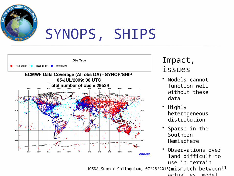
SYNOPS, SHIPS
Impact, issues• Models cannot function
well without these data
• Highly heterogeneous distribution
• Sparse in the Southern Hemisphere
• Observations over land difficult to use in terrain (mismatch between actual vs. model topography)

JCSDA Summer Colloquium, 07/28/2015 12
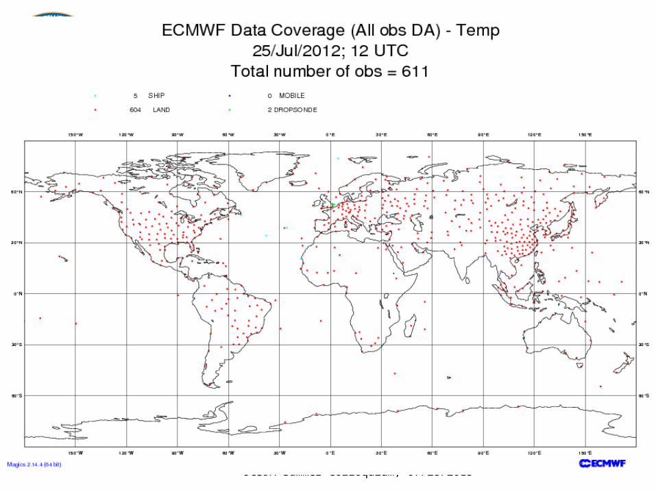
In situ measurements Balloon-borne radiosondes
TEMP - u, v, T, q at synoptic times (00 and 12 Z) at ~600 locations mostly over the densely populated regions in the NH
PILOT - u, v at synoptic times (6 and 18Z) at limited number of locations
Dropsondes (targeted) Aircraft measurements Research balloons

JCSDA Summer Colloquium, 07/28/2015 13
Radiosondes (TEMP)• “Point” measurements of (Z),T, u, v, q • Essential for NWP skill, both directly and indirectly (satellite
radiance bias correction)• Time sampling is problematic
• Different parts of the globe systematically sampled at different local times
• Horizontal sampling is inadequate (minimal SH, oceanic coverage)• Little or no stratospheric penetration• Quality control very difficult
• Different operating (and reporting) practices• Different models and manufacturers of on-board sensors
• Operating costs (~$B/year; some nations reducing to save)
JCSDA Summer Colloquium, 07/28/2015 14

JCSDA Summer Colloquium, 07/28/2015 15
Aircraft observations PIREP - human report, provided by both
general and commercial aviation; no longer widely used for NWP
AIREP - human report, regular lat/lon intervals, disseminated on WMO GTS
AMDAR - automated observations of u,v,T transmitted to ground via terrestrial or satellite radio, disseminated on GTS Both ascent/descent profiles and flight level
information widely used for NWP Pilot programs with on-board humidity
sensors both in Europe and the US (primarily for profiling)

JCSDA Summer Colloquium, 07/28/2015 16
AMDAR Large and growing NWP impact Anisotropic sampling both horizontally and vertically Flight level winds represent a biased sampling
(routing driven by fuel savings) Vertical profiles are sparse (ascent/descent near
major airports) Difficult QC problem
E.g. record does not include aircraft tail number

JCSDA Summer Colloquium, 07/28/2015 17

JCSDA Summer Colloquium, 07/28/2015 18
Space-based components of the GOS
Geostationary orbit Polar orbit
Sun-synchronous

JCSDA Summer Colloquium, 07/28/2015 19
Geostationary satellites
An international constellation of ~6 operational satellites at 35,800 km altitude at fixed longitudes in the Earth’s equatorial plane High temporal resolution imaging Extremely valuable for monitoring &
nowcasting High and “upper middle” latitudes not well
covered Data assimilation previously considered a
secondary Changing with advances in time-dependent DA Changing with coming of more “sounder-like”
sensors

JCSDA Summer Colloquium, 07/28/2015 20
AMV (SATWIND)
Winds derived from tracking of features in cloud (or WV) field in imagery from geostationary and polar platforms
Large and growing impact on NWP skill Single level coverage No operational high-latitude coverage
Experimental dataset available from MODIS Difficult quality control problem
Errors in assigned height can lead to negative impact
Errors in tracking can lead to gross errors

JCSDA Summer Colloquium, 07/28/2015 21

JCSDA Summer Colloquium, 07/28/2015 22
GOES-R: Coming 2016
H8 Image of Typhoon – 7/7/15

JCSDA Summer Colloquium, 07/28/2015 23
Polar orbiters Large fleet of research and operational
satellites in a variety of “polar” orbits (many sun-synchronous) provides NWP impact (see later slides) w/resilience Operational satellites include:
NOAA/NESDIS: POES, S-NPP, JPSS (coming) EUMETSAT: METOP A and B China
Research satellites include NASA: Aqua/AIRS, Terra, GPM, SMAP JAXA ESA CSA

JCSDA Summer Colloquium, 07/28/2015 24
Polar orbiters (II) Observations are asynoptic by nature
Typical orbit height between 350 and 850 km; velocity relative to ground ~7 km/s
Global coverage is “patched” together over a period of 12 or 24 hours or longer
Data assimilation is the primary application for several polar orbiting sensors
Microwave sounders and hyperspectral IR sounders are among the most important data sources for NWP

JCSDA Summer Colloquium, 07/28/2015 25
Microwave Sounders
Essential for NWP (AMSU-A typically ranked at or near the top in terms of impact on skill)
Best global coverage of any observing system Requires observation operators (radiative
transfer modeling) Use of surface sensing channels problematic;
emissivity of snow, ice, land, and to some extent sea
Clouds, precipitation affect Inter-instrument biases

JCSDA Summer Colloquium, 07/28/2015 26

JCSDA Summer Colloquium, 07/28/2015 27
Hyperspectral IR sounders(AIRS, IASI, CrIS)
Typically ranked at or near the top in terms of impact on skill per instrument
Prolific data source (billions of measurements per day)
Only a small fraction these used for NWP due to difficulties with Clouds Model prediction (WV) Surface emissivity Correlated information Data volume

28JCSDA Summer Colloquium,
07/28/2015

Slide from Cucurull
29JCSDA Summer Colloquium, 07/28/2015

JCSDA Summer Colloquium, 07/28/2015 30
GPSRO Medium/high impact on NWP skill Large impact especially in the upper troposphere Free from calibration drift; can be used to calibrate
data from other observing systems Assimilation methodology still evolving: From T/q
to refractivity to bending angle to phase delay …. Unusual (complementary) measurement geometry
due to limb approach Good global coverage can be obtained by
constellation approach (COSMIC and COSMIC-2)

Other satellite sensors used for assimilation or validation of NWP
Scatterometers and Synthetic Aperture Radars Radar altimeters (Ocean Surface Topograpghy) Microwave imagers VIS/IR imagers Precipitation radars Cloud radars Aerosol lidars UV imagers/spectrometers for atmospheric
composition New sensors
GOES-R Lighting Mapper (GLM) Soil Moisture Active/Passive Doppler Wind LidarJCSDA Summer Colloquium, 07/28/2015 31

Impact assessment (I)
Observing system simulation experiments (data denials) No additional development required Computational expensive to run
Typically require runs in TWO seasons Only bulk measure of impact
But more statistically significant that case studies Focusing on the medium range Many different measures of skill can be studied
for a given set of experimentsJCSDA Summer Colloquium, 07/28/2015 32

500 hPa Anomaly Correlations15 Aug – 30 Sep 2010
33
No Satellite / No Conventional Data
Northern Hemisphere
Southern Hemisphere
JCSDA Summer Colloquium, 07/28/2015
(J. Jung, 5th WMO Impact Workshop, Sedona 2012)

Impact assessment (II)
Forecast Sensitivity to Observations (FSO) Development-intensive (e.g. adjoint of
forecast model) Relatively inexpensive to run Detailed “per ob” apportionment of impact Focus on impact of the observation on skill
during first 24 h (assumption of linearity) Method only shows impact on one pre-
defined cost function per calculationJCSDA Summer Colloquium, 07/28/2015 34
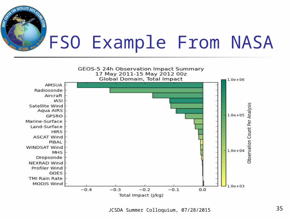
FSO Example From NASA
JCSDA Summer Colloquium, 07/28/2015 35

The future of the GOS Recognizing that the mandates of most National
Meteorological and Hydrological Services are expanding, WMO has decided to implement WIGOS, the WMO Integrated Global Observing System
“GOS++”, or GOS with Observations (beyond those needed for weather
applications) of climate, atmospheric composition, oceans, land surface, hydrology parameters
RRR fully integrated for all components Quality Management Framework Disseminated via WIS (WMO Information System)
JCSDA Summer Colloquium, 07/28/2015 36

GOS in Summary (1)
Critical collection of infrastructure for meteorology and NWP
Complex with many stakeholders Users Providers
“Somewhat opaque management structure and decision-making processes”
JCSDA Summer Colloquium, 07/28/2015 37

GOS in Summary (2)
In spite of its successes, the heterogeneity of the GOS poses an enormous challenge to the data assimilation/NWP community
Quality control Bias Observation operators (relationship between
observed and modeled variables) Data latency
Data assimilation community can help define the GOS of the future
JCSDA Summer Colloquium, 07/28/2015 38