Embed Size (px)
Citation preview

Title 21: Land Use Planning PUBLIC REVIEW DRAFT #2 – JANUARY 2006 Anchorage, Alaska Page 505
TABLE OF CONTENTS 1 2
CHAPTER 21.13: RULES OF CONSTRUCTION AND DEFINITIONS....................................506 3 21.13.010 Interpretations ...............................................................................................................506 4
A. General .....................................................................................................................506 5 B. Record of Interpretations ..........................................................................................506 6 C. Appeal.......................................................................................................................506 7
21.13.020 Rules of Construction and Interpretation...................................................................506 8 A. Meanings and Intent .................................................................................................506 9 B. Headings, Illustrations, and Text ..............................................................................506 10 C. Lists and Examples ..................................................................................................506 11 D. Computation of Time ................................................................................................506 12 E. References to Other Regulations/Publications ........................................................506 13 F. Delegation of Authority .............................................................................................507 14 G. Technical and Non-Technical Terms........................................................................507 15 H. Public Officials and Agencies ...................................................................................507 16 I. Mandatory and Discretionary Terms ........................................................................507 17 J. Conjunctions.............................................................................................................507 18 K. Tenses, Plurals, and Gender....................................................................................507 19 L. Measurement of Distances For Separation of Land Uses .......................................507 20
21.13.030 Definitions......................................................................................................................507 21 22
23 24

Title 21: Land Use Planning PUBLIC REVIEW DRAFT #2 – JANUARY 2006 Anchorage, Alaska Page 506
CHAPTER 21.13: RULES OF CONSTRUCTION AND DEFINITIONS 1
21.13.010 INTERPRETATIONS1 2
A. General 3
The director has final authority to determine the interpretation or usage of terms used in 4 this title, pursuant to this section. Any person may request an interpretation of any term 5 by submitting a written request to the director, who shall respond in writing within 30 6 days. The director’s interpretation shall be binding on all officers and departments of the 7 municipality. 8
B. Record of Interpretations 9
The director shall maintain a file of all interpretations made pursuant to this subsection. 10
C. Appeal 11
Any person may appeal an interpretation by the director regarding a term used in this title 12 to the zoning board of examiners and appeals in accordance with section 21.03.210B. 13
21.13.020 RULES OF CONSTRUCTION AND INTERPRETATION 14
The following rules shall apply for construing or interpreting the terms and provisions of this chapter. 15
A. Meanings and Intent 16
All provisions, terms, phrases, and expressions contained in this chapter shall be 17 construed according to the general purposes set forth in section 21.01.030 and the 18 specific purpose statements set forth throughout this chapter. When, in a specific section 19 of this chapter, a different meaning is given for a term defined for general purposes in this 20 chapter 21.13, the specific section’s meaning and application of the term shall control. 21
B. Headings, Illustrations, and Text 22
In the event of a conflict or inconsistency between the text of this chapter and any 23 heading, caption, figure, illustration, table, or map, the text shall control. 24
C. Lists and Examples 25
Unless otherwise specifically indicated, lists of items or examples that use terms such as 26 “for example,” “including,” and “such as,” or similar language are intended to provide 27 examples and are not exhaustive lists of all possibilities. 28
D. Computation of Time 29
The time in which an act is to be done shall be computed by excluding the first day and 30 including the last day. If a deadline or required date of action falls on a Saturday, 31 Sunday, or holiday observed by the municipality, the deadline or required date of action 32 shall be the next day that is not a Saturday, Sunday, or holiday observed by the 33 municipality. References to days are calendar days unless otherwise stated. 34
E. References to Other Regulations/Publications 35
Whenever reference is made to a resolution, ordinance, statute, regulation, or document, 36 it shall be construed as a reference to the most recent edition of such regulation, 37
Chapter 21.13: Rules of Construction and Definitions Definitions
Title 21: Land Use Planning PUBLIC REVIEW DRAFT #2 – JANUARY 2006 Anchorage, Alaska Page 507
resolution, ordinance, statute, regulation, or document, unless otherwise specifically 1 stated. 2
F. Delegation of Authority 3
Any act authorized by this chapter to be carried out by a specific official of the 4 municipality may be carried out by a designee of such official. 5
G. Technical and Non-Technical Terms 6
Words and phrases shall be construed according to the common and approved usage of 7 the language, but technical words and phrases that have acquired a peculiar and 8 appropriate meaning in law or practice shall be construed and understood according to 9 such meaning. 10
H. Public Officials and Agencies 11
All public officials, bodies, and agencies to which references are made are those of the 12 municipality, unless otherwise indicated. 13
I. Mandatory and Discretionary Terms 14
The words “shall,” “must,” and “will” are mandatory in nature, establishing an obligation or 15 duty to comply with the particular provision. The words “may” and “should” are 16 permissive in nature. 17
J. Conjunctions 18
Unless the context clearly suggests the contrary, conjunctions shall be interpreted as 19 follows: 20
a. “And” indicates that all connected items, conditions, provisions or events 21 apply; and 22
b. “Or” indicates that one or more of the connected items, conditions, 23 provisions or events apply. 24
K. Tenses, Plurals, and Gender 25
Words used in the present tense include the future tense. Words used in the singular 26 number include the plural number and the plural number includes the singular number, 27 unless the context of the particular usage clearly indicates otherwise. Words used in the 28 masculine gender include the feminine gender, and vice versa. 29
L. Measurement of Distances For Separation of Land Uses 30
Except where stated otherwise, whenever this title requires measurement of distance 31 between use types, development sites, or lots, such measurement shall be made from 32 the nearest property line of the first reference point to the property line of the second 33 reference point. 34
21.13.030 DEFINITIONS2 35
When used in this title, the following words and terms shall have the meaning set forth in this 36 section, unless other provisions of this title specifically indicate otherwise. 37

Chapter 21.13: Rules of Construction and Definitions Abutting
Title 21: Land Use Planning PUBLIC REVIEW DRAFT #2 – JANUARY 2006 Anchorage, Alaska Page 508
Abutting 1 Adjoining or bordering. 2 3 Abutting Lots 4 Two lots abut when they share a common lot line. 5
Access 6 A way or means of approach to provide vehicular or pedestrian physical entrance to a property. 7
Accessibility 8 The extent to which a property is easily accessed or approached. 9 10 Adjacent 11 Near or close to, but not necessarily touching or bordering. 12 13 Adjacent Lots 14 Two lots are adjacent where they have a common lot line or where they are separated only by an alley or 15 a street right-of-way. 16
Airport Elevation 17 The highest point of an airport's usable landing area, measured in feet above mean sea level. 18
Alaska Water Quality Standards 19 Those standards set forth in title 18, chapter 70, of the Alaska Administrative Code. 20
Alley 21 A permanent service right-of-way providing a secondary means of access to abutting properties. 22
AMC 23 Anchorage Municipal Code. 24
Amortization 25 A process where a legal nonconforming use, characteristic of use, structure, lot, or sign is required to be 26 brought into compliance with the requirements of this title over a period of time with sufficient length to 27 allow the owner of the legal nonconformity to realize any reasonable investment-backed expectations 28 regarding the legal nonconformity. 29
Anchorage Metropolitan Area Transportation Solutions (AMATS) 30 The transportation planning process for the municipality. 31
Antenna or Antenna Array 32 Any exterior transmitting or receiving device mounted on a tower, building, or structure and used in 33 communications that radiate or capture electromagnetic waves, digital signals, analog signals, radio 34 frequencies (excluding radar signals), amplitude modulation arrays, wireless telecommunications signals, 35 or other communications signals. 36
Approach, Transitional, Horizontal, and Conical 37 Surfaces or zones that are airspace zones defined as set forth in FAR part 77, subpart C, paragraph 38 77.25. 39
Architectural Feature (as used in chapter 21.10, Signs) 40 Any construction attendant to, but not an integral part of the sign, which may consist of landscape, 41 building, or structural forms that enhance the site in general; also, graphic stripes and other architectural 42 painting techniques applied to a structure that serves a functional purpose, or when the stripes or other 43

Chapter 21.13: Rules of Construction and Definitions Architectural Feature (as used in chapter 21.07, Development and Design Standards)
Title 21: Land Use Planning PUBLIC REVIEW DRAFT #2 – JANUARY 2006 Anchorage, Alaska Page 509
painting techniques are applied to a building provided such treatment does not include lettering, logos or 1 pictures. 2
Architectural Feature (as used in chapter 21.07, Development and Design Standards) 3 A part, portion, or projection that contributes to the aesthetic quality of a building or structure, exclusive of 4 signs, that is not necessary for the structural integrity of the building structure or to make the building or 5 structure habitable. 6
Architectural Bay 7 A spatial division of a wall, usually repeated at intervals as part of a series, marked off by vertical 8 supports of a structure. 9
Area, Building 10 The total of areas taken on a horizontal plane at the main grade level of the principal building and all 11 accessory buildings or structures exclusive of steps. 12
Area Lighting 13 Light fixtures located on public or private property that are designed to light spaces. Area lighting does 14 not include façade or landscape lighting. 15
Assembly 16 The assembly of the municipality. 17
Assisted Living 18 Has the same meaning as set forth in Alaska statutes chapter 47.33. 19
Average 20 The equaling of an arithmetic mean. As used in section 21.07.080, Landscaping, Screening, and Fences, 21 this shall be interpreted to mean the plantings may be grouped together in such a way as the designer 22 may choose so long as the total number of plants meets the standard. 23
Average Slope 24 Average slope is calculated by the following formula: 25
S = (I x L x 0.0023) / A 26
Where: 27
S = Average slope of lot or tract in percent. 28
I = Contour interval (20 feet or less). 29
L = Sum of the length of all contours on lot or tract in feet. 30
A = Area of the lot or tract in acres. 31
Base Flood (100-Year) 32 The flood having a one percent chance of being equaled or exceeded in any given year. 33
Billboard 34 A sign structure advertising an establishment, merchandise, event, service or entertainment that is not 35 sold, produced, manufactured or furnished at the property on which the sign is located. Any other 36 outdoor advertising prohibited by the provisions of Alaska statutes sections 19.25.075 – 19.25.180 shall 37 also be considered billboards. 38

Chapter 21.13: Rules of Construction and Definitions Block
Title 21: Land Use Planning PUBLIC REVIEW DRAFT #2 – JANUARY 2006 Anchorage, Alaska Page 510
Block 1 A block is defined by an area of land bounded by streets, or a combination of streets, railroad utility 2 corridor, shorelines of waterways, or municipal boundary lines. 3
Block Length 4 The distance between intersections of through streets, such distance being measured along the longest 5 street bounding the block and from right-of-way line to right-of-way line of the two intersecting streets. 6
Board of Adjustment 7 The board of adjustment of the municipality. 8
Board of Examiners and Appeals 9 The zoning board of examiners and appeals of the municipality. 10
Bollard-Style Lighting 11 Lighting consisting of short posts that incorporate a lighting element. 12
Brightness 13 The human perception of luminance. See Luminance and Candela. 14
Buffer, Perimeter 15 A unit of land and any plants and structures (i.e., walls, fences) thereon that is used to separate land uses 16 from each other. 17
Building 18 Any structure built for the support, shelter, or enclosure of persons, animals, chattels, or property of any 19 kind. 20
Building, Accessory 21 A building or structure that is on the same lot as, and of a nature customarily incidental and subordinate 22 to, a principal building or structure, and the use of which is clearly incidental and subordinate to that of the 23 principal building or structure. 24
Building Envelope 25 The three-dimensional space within which a structure is permitted to be built on a lot and which is defined 26 by regulations governing setbacks, maximum height and bulk; by other regulations; or any combination 27 thereof. 28
Building, Front Line of 29 The line of that part of the building nearest the front property line of the lot. 30
Building, Principal 31 A structure in which is conducted the main use of the lot on which the structure is situated. 32
Building Permit 33 See Permit, Building. 34
Building Wall (as used in chapter 21.10, Signs) 35 Any vertical surface of a building or structure (other than a pitched roof) that is integral to and could 36 reasonably be constructed as part of the architecture of the building when a sign(s) is not being 37 contemplated. Examples of building walls include but are not limited to: awnings, canopies, marquees, 38 the vertical portion of gable roofs, parapets, mechanical penthouses, etc. 39

Chapter 21.13: Rules of Construction and Definitions Business
Title 21: Land Use Planning PUBLIC REVIEW DRAFT #2 – JANUARY 2006 Anchorage, Alaska Page 511
Business 1 An enterprise that for consideration will provide for the sale or the rental of any article, substance, or 2 commodity, including but not limited to business services and personal services. 3
Caliper 4 The diameter of a tree six inches above the ground. 5
Camper 6 A portable structure mounted on a truck or truck chassis or a converted hearse, bus, station wagon or 7 panel truck designed for use as a temporary travel dwelling. 8
Candela 9 A unit measuring luminous intensity of a lighting source. An ordinary candle has a luminous intensity of 10 one candela. See Luminance. 11
Canopy 12 A permanent architectural element projecting out from a building façade over a sidewalk or walkway. A 13 canopy shall be at least five feet in horizontal width, and no less than eight feet and no more than 15 feet 14 above grade. 15
Cartway 16 The paved area of a street between the curbs, including travel lanes and parking areas, but not including 17 shoulders, curbs, sidewalks, or swales. If curbs are lacking and parking is restricted to shoulders, the 18 cartway is defined as the travelway (exclusive of shoulders). 19
CATV 20 A utility that operates non-broadcast facilities that distribute to subscribers the signals of one or more 21 television broadcast stations. 22
Certificate to Plat 23 A certificate prepared by a title company authorized by the laws of the state to write the title, showing the 24 names of all persons having any record title interest in the land to be platted, together with the nature of 25 their respective interests therein. 26
Certificate of Occupancy 27 A certificate of zoning compliance issued by the municipality allowing the occupancy or use of a building 28 in the building safety service area, and certifying that the structure or use has been constructed or will be 29 used in compliance with all applicable municipal codes and ordinances. 30
Certificate of Zoning Compliance 31 A document issued by the municipality indicating that a structure or use meets the applicable zoning 32 requirements at the time of issuance. 33
Civil Penalty 34 A fine levied by the municipality for a violation of this title. 35

Chapter 21.13: Rules of Construction and Definitions Clearing
Title 21: Land Use Planning PUBLIC REVIEW DRAFT #2 – JANUARY 2006 Anchorage, Alaska Page 512
Clearing 1 The removal of woody plants over six inches above the ground, without disturbing the vegetative mat, 2 using any method. 3 4 Collocation 5 The location of antennae on existing structures, including but not limited to towers occupied by another 6 provider, buildings, water towers, utility substations, utility poles, and church steeples. 7 8 Color Rendering Index (of a light source) (CRI) 9 A measure of the degree of color shift that objects undergo when illuminated by the light source as 10 compared with those same objects when illuminated by a reference source of comparable color 11 temperature. 12
Combination 13 The elimination of interior lot lines in a subdivision that does not involve the vacation of dedicated streets, 14 easements, or public areas. 15
Commercial 16 An enterprise involved in the production, processing, or merchandising of a commodity for, usually, but 17 not necessarily, a profit. 18 19 Commercial Development 20 A planned commercial center designed specifically for commercial use. 21
Commercial Tract Site Plan 22 A map of a commercial tract depicting building footprints, parking areas, landscaping, driveway access 23 points to the property, site drainage and any fragment lots to be contained within the commercial tract. 24
Common Areas and Facilities 25 Those areas of a subdivision, building, planned unit development or condominium, including the property 26 upon which it is located, that are for the common use and enjoyment of the owners and occupants of the 27 subdivision, building, planned unit development or condominium. The areas may include the land, roofs, 28 main walls, elevators, staircases, lobbies, halls, parking space, open space, and communal facilities. 29 Common areas are shared by all tenants and are distinguished from space designated for private use. 30
Common Wall 31 A wall extending from the footing of a building to the roof along a side lot line between two lots on which 32 the building is located. 33
Community Council 34 Nonprofit, voluntary, self-governing associations composed of residents, property owners, business 35 owners, and representatives from nonprofit associations and other entities located within geographical 36 areas designated as districts by the assembly. Residents, for the purpose of this chapter, are defined as 37 residents, property owners, and representatives from nonprofit associations and other entities located 38 within geographical areas designated as districts by the assembly. 39
Comprehensive Plan 40 The collection of long-range municipal planning documents and maps that serves as the official policy 41 guide for the long-range physical, social, and economic development of the municipality, including the 42 provision of its public infrastructure and services. The comprehensive plan is comprised of a series of 43 distinct plans adopted by the assembly as elements of the comprehensive plan, that each deal with 44 separate aspects of community planning. The term "comprehensive plan" as used in this title refers to 45 any or all of these long-range plans that taken together constitute the comprehensive plan for the 46 municipality. 47

Chapter 21.13: Rules of Construction and Definitions Comprehensive Plan Amendment, Cosmetic
Title 21: Land Use Planning PUBLIC REVIEW DRAFT #2 – JANUARY 2006 Anchorage, Alaska Page 513
Comprehensive Plan Amendment, Cosmetic 1 An amendment that affects the appearance, style, wording, or presentation of the comprehensive plan, 2 but does not alter its meaning, interpretation, or recommendations. Examples of cosmetic amendments 3 include, but are not limited to: revising map or document style, format, or layout to enhance clarity; 4 revising map or text content to accurately reflect additions to municipal facilities or revisions to adjoining 5 jurisdictions' adopted plans; adding explanatory text or labels; and correcting spelling or grammar. 6
Comprehensive Plan Amendment, Substantive 7 An amendment that affects the intent of the comprehensive plan. Examples of substantive amendments 8 include, but are not limited to: revising text to address a new policy direction or the addition of a new 9 zoning district. 10
Comprehensive Plan Map 11 An element of the Anchorage Comprehensive Plan, comprised of one or more land use plan maps, 12 residential intensity maps, and other maps, as well as supporting text and tables. The comprehensive 13 plan map provides a geographically explicit statement of the adopted plan’s policies for future land use 14 and growth. It designates the ultimate future location, density, and general character of land uses in the 15 community. It also serves as a guide for the official zoning map. 16 17 Construction 18 Design, engineering, contract administration, work, labor, and materials furnished for an improvement. 19
CRI 20 See Color Rendering Index. 21
Critical Root Zone 22 The area beneath a tree's crown, within the tree's drip line, or one foot distance from the trunk for each 23 one inch in diameter, whichever is greater. The critical root zone is the portion of the root system that is 24 the minimum necessary to maintain the vitality or stability of the tree. 25
DBH (as used in section 21.07.020, Natural Resource Protection) 26 “Diameter at breast height,” or diameter of a tree at four and one-half feet off the ground. 27
Daylight Plane 28 An inclined plane, beginning at a stated height above grade at a property or setback line, and extending 29 into the site at a stated upward angle to the horizontal, which may limit the height or horizontal extent of 30 structures at any specific point on the site where the daylight plane is more restrictive than the height limit 31 or the minimum setback applicable at such point on the site. 32 33 Decision-Making Body 34 The person, board, or commission with the authority to approve, modify, or deny an entitlement 35 application, as stated in section 21.02.020 and elsewhere in this title. 36 37 Dedication 38 The devotion of land to a public use by the owner manifesting the intention that it shall be accepted and 39 used presently or in the future for such public purpose. A dedication by the owner under the terms of this 40 subsection is a conveyance of an interest in property, which shall be deemed to include the warranties of 41 title listed in AS 34.15.030. The dedication of streets, alleys, sidewalks, or public open space shall 42 convey a fee interest in the area dedicated. The dedication of all other public rights-of-way, including 43 utility rights-of-way, shall be deemed to create an easement in gross to perform the indicated function in 44 the area depicted. 45
Defined Bank 46 The usual boundaries, not the flood boundaries, of a stream channel. 47

Chapter 21.13: Rules of Construction and Definitions Density, Gross
Title 21: Land Use Planning PUBLIC REVIEW DRAFT #2 – JANUARY 2006 Anchorage, Alaska Page 514
Density, Gross 1 The number of dwelling units per acre in any residential development. 2 3 Density, Net 4 The total number of dwelling units on a particular tract or parcel of land, not taking into account portions of 5 the tract or parcel that contain rights-of-way for streets, lakes, other water bodies, wetlands falling under 6 the regulatory jurisdiction of the U.S. Army Corps of Engineers, or other areas restricted from developed 7 by this title. 8
Department 9 Unless otherwise indicated in the text of this code, the planning department of the municipality. 10
Depth 11 When viewed from the front of an object or a three-dimensional space, the measurement from a forward 12 plane to a rearward plane. 13 14 Developer 15 That person or entity improving or developing land, who may or may not be the owner of the property. 16
Development 17 The initiation, construction, change, or enlargement of any use or structure, the disturbance of land, or the 18 division of land into two or more parcels. “Development” shall include, but not be limited to, the following: 19
• Construction or enlargement of a building or structure; 20
• Change in the type of use of a building, structure, or land; 21
• Material increase in the intensity of use of land, such as an increase in the number of businesses, 22 offices, manufacturing establishments, or dwelling units located in a building or structure or on the 23 land; 24
• Commencement or expansion of resource extraction, agricultural, horticultural, or forestry activities on 25 a parcel of land; 26
• Demolition of a structure or the removal of vegetation from a parcel of land; 27
• Deposition of refuse, solid or liquid waste, or fill on a parcel of land; 28
• Alteration, either physically or chemically, of the shore, bank, or channel of any stream, lake, or other 29 body of water or alteration of any wetland; and 30
• Any land-disturbing activity that adds to or changes the amount of impervious or partially impervious 31 cover on a land area or which otherwise decreases the infiltration of precipitation into the soil. 32
Disability (or Handicap) 33 Has the same meaning as “disability,” pursuant to the Americans with Disabilities Act of 1990, as 34 amended, 42 U.S.C. 126. 35
Director 36 Unless otherwise indicated in the text of this code, the director of the planning department or designee. 37

Chapter 21.13: Rules of Construction and Definitions Double-Frontage Lot
Title 21: Land Use Planning PUBLIC REVIEW DRAFT #2 – JANUARY 2006 Anchorage, Alaska Page 515
Double-Frontage Lot 1 See Lot, Double-Frontage 2 3 Dwelling 4 A building or portion of a building designed or used exclusively as the living quarters for one family. 5
Easement 6 An interest in land owned by another that entitles the easement holder to a specified limited use or 7 enjoyment. 8
Elevation, Building 9 A geometrical projection of a structure on a vertical picture plane parallel to one of its sides, drawn to 10 scale. 11 12 Encroachment 13 The projection or intrusion of a building, structure, or other land-disturbing activity into an area where 14 such projections or intrusions are typically prohibited. 15
Engineer 16 A registered professional civil engineer authorized to practice engineering in the state of Alaska. 17
Entitlement 18 Any permit or approval granted under this title, including, but not limited to zoning map amendments, 19 conditional use permits, preliminary or final plat approval, site plan approval, and variances. For 20 purposes of administering and enforcing this title, the term also includes building and land use permits. 21
Entrance, Primary 22 A principal entry through which people, including customers, residents, or members of the public enter a 23 building. For any commercial or institutional establishment which serves the visiting public, a primary 24 entrance is open to the public during all business hours and directly accesses lobby, reception, retail, or 25 other interior areas designed to receive the public. Fire exits, service doors, and employee entrances are 26 not primary entrances. A building or establishment may have more than one primary entrance. 27 28 Erosion 29 The wearing away of land surface by the action of wind, water, gravity, or any combination thereof. 30
Erosion Control 31 A measure, structure, or device that controls the soil material within the land area under responsible 32 control of the person conducting a land-disturbing activity. 33
Existing Vegetation 34 Vegetation that predates a development application by at least two years. 35
36 Ex Parte Contact 37 A communication involving a municipal official and a member of the public or a municipal consultant 38 regarding a pending quasi-judicial matter or appeal, such that the municipal official may be exposed to 39 only one perspective or part of the evidence with regard to a quasi-judicial matter pending before the 40 commission or board on which the municipal official serves. Ex parte communications occur at other than 41 a public meeting of the commission or board on which the municipal official serves at which the quasi-42 judicial matter discussed has been publicly noticed. 43

Chapter 21.13: Rules of Construction and Definitions Extent Reasonably Feasible
Title 21: Land Use Planning PUBLIC REVIEW DRAFT #2 – JANUARY 2006 Anchorage, Alaska Page 516
Extent Reasonably Feasible 1 Under the circumstances, reasonable efforts have been undertaken to comply with the regulation, that the 2 costs of compliance clearly outweigh the potential benefits to the public, or would unreasonably burden 3 the proposed project, and reasonable steps have been undertaken to minimize any potential harm or 4 adverse impacts resulting from noncompliance with the regulation. 5
Façade, Building 6 A vertical plane of a structure. 7 8 Family 9 One or more persons occupying premises and living as a single housekeeping unit, as distinguished from 10 a group occupying a roominghouse, club, fraternity house or hotel. 11
FAR 12 See Floor Area Ratio. 13 14 Feature, Architectural 15 See Architectural Feature. 16
Fence 17 An artificially constructed barrier which is erected to enclose, screen, buffer, enhance or separate areas. 18 19 Fence, Open 20 A fence constructed with openings between materials used in its construction, such that three-fourths 21 (75%) or more of a visual image or light source may be seen through the fence. 22
Fence, Semi-Open 23 A fence constructed with openings between materials used in its construction, such that less than 75% of 24 a visual image or light source may be seen through the fence. 25
Fence, Screening (Opaque) 26 A fence, including any gates, constructed of solid material, wood or masonry, through which no visual 27 images or light sources may be seen. 28
Final Acceptance 29 Acceptance by the municipality, at the completion of construction, of a public improvement, constructed 30 under terms of a subdivision agreement. 31
Flag 32 Any fabric, banner or bunting containing distinctive colors, patterns or symbols, used as a symbol of a 33 government, political subdivision, corporate or commercial entity, or institution. A corporate or 34 commercial, or institutional flag may only display the name, trademark, or logo of the business or 35 institution on the parcel and such flag may not be used for other business or advertising purposes. 36
Flag Lot 37 See Lot, Flag. 38 39 Flood and Flooding 40 A general and temporary condition of partial or complete inundation of normally dry land areas from: 41
• The overflow of inland or tidal waters. 42
• The unusual or rapid accumulation or runoff of surface waters from any source. 43

Chapter 21.13: Rules of Construction and Definitions Flood Insurance Rate Map (FIRM)
Title 21: Land Use Planning PUBLIC REVIEW DRAFT #2 – JANUARY 2006 Anchorage, Alaska Page 517
• Mudslides that are proximately caused or precipitated by accumulations of water on or under the 1 ground. 2
• The collapse or subsidence of land along the shore of a lake or other body of water as a result of 3 erosion or undermining caused by waves or currents of water exceeding anticipated cyclical levels or 4 suddenly caused by an unusually high water level in a natural body of water, accompanied by a 5 severe storm, or by an unanticipated force of nature, such as a flash flood or an abnormal tide surge, 6 or by some similarly unusual or unforeseeable event which results in flooding as defined in this 7 subsection. 8
Flood Insurance Rate Map (FIRM) 9 The official map on which the Federal Insurance Administration has delineated both areas of special flood 10 hazards and the risk premium zones applicable to the community. 11
Flood Insurance Study 12 The official report provided by the Federal Insurance Administration that includes flood profiles, the flood 13 boundary/floodway map, and the water surface elevation of the base flood. 14
Flood Hazard Area 15 Land adjacent to a watercourse that includes the streambed, floodway, flood fringe, and the floodplain. 16
Floodplain 17 That area of land adjoining the channel of a river, stream or other similar body of water which may be 18 inundated by a flood that can reasonably be expected to occur. The floodplain, shall include all the land 19 within the limits of the 100-year flood, and the floodway within it if such floodway is delineated. 20
Floodproofing 21 Any combination of structural and nonstructural additions, changes or adjustments to structures which 22 reduce or eliminate flood damage to real estate or improved real property, water and sanitary facilities, 23 structures and their contents. 24
Floodway, Regulatory 25 The channel of a river or other watercourse and the adjacent land areas that must be reserved in order to 26 discharge the base flood without cumulatively increasing the water surface elevation more than one foot. 27 The boundaries of this area shall be established on the basis of the maps and reports adopted by section 28 21.04.070.E, Flood Hazard Overlay District. 29
Floodway Fringe 30 That area of land lying between the outer limit of the regulatory floodway and the outer limit of the base 31 flood elevation. The boundaries of this area shall be established on the basis of the maps and reports 32 adopted by section 21.04.070.E, Flood Hazard Overlay District. 33
Floor Area Ratio (FAR) 34 The maximum gross floor area of all buildings on a lot or parcel, divided by the area of the lot or parcel. 35 (A floor area ratio of 2.0 provides for 23,000 gross square feet of building area on a lot with an area of 36 11,500 square feet.) 37
Footcandle 38 A unit of measure of the intensity of light falling on a surface, equal to one lumen per square foot and 39 originally defined with reference to a standardized candle burning at one foot from a given surface. 40
Fragment Lot 41 A division of a commercial tract for purposes of facilitating construction or financing of a commercial 42 development requiring multiple phases of construction. The term "fragment lot" does not include 43
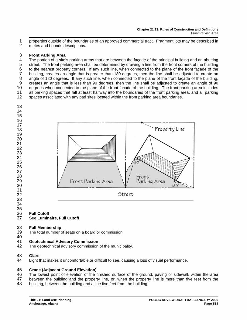
Chapter 21.13: Rules of Construction and Definitions Front Parking Area
Title 21: Land Use Planning PUBLIC REVIEW DRAFT #2 – JANUARY 2006 Anchorage, Alaska Page 518
properties outside of the boundaries of an approved commercial tract. Fragment lots may be described in 1 metes and bounds descriptions. 2
Front Parking Area 3 The portion of a site’s parking areas that are between the façade of the principal building and an abutting 4 street. The front parking area shall be determined by drawing a line from the front corners of the building 5 to the nearest property corners. If any such line, when connected to the plane of the front façade of the 6 building, creates an angle that is greater than 180 degrees, then the line shall be adjusted to create an 7 angle of 180 degrees. If any such line, when connected to the plane of the front façade of the building, 8 creates an angle that is less than 90 degrees, then the line shall be adjusted to create an angle of 90 9 degrees when connected to the plane of the front façade of the building. The front parking area includes 10 all parking spaces that fall at least halfway into the boundaries of the front parking area, and all parking 11 spaces associated with any pad sites located within the front parking area boundaries. 12
13 14 15 16 17 18 19 20 21 22 23 24 25 26 27 28 29 30 31 32 33 34 35 Full Cutoff 36 See Luminaire, Full Cutoff 37
Full Membership 38 The total number of seats on a board or commission. 39 40 Geotechnical Advisory Commission 41 The geotechnical advisory commission of the municipality. 42
Glare 43 Light that makes it uncomfortable or difficult to see, causing a loss of visual performance. 44
Grade (Adjacent Ground Elevation) 45 The lowest point of elevation of the finished surface of the ground, paving or sidewalk within the area 46 between the building and the property line, or, when the property line is more than five feet from the 47 building, between the building and a line five feet from the building. 48

Chapter 21.13: Rules of Construction and Definitions Greenbelt
Title 21: Land Use Planning PUBLIC REVIEW DRAFT #2 – JANUARY 2006 Anchorage, Alaska Page 519
Greenbelt 1 A linear open space established along either a natural corridor, such as a riverfront, stream valley, or 2 ridge line, or over land along a railroad utility corridor converted to recreational use, a canal, a scenic 3 road, or other route. 4
Grid 5 The 100-scale grid designation as established by the municipality. 6
Gross Area 7 The total site area, excluding bodies of water, to be included within a proposed development as indicated 8 on a site plan. 9
Gross Floor Area 10 The total horizontal area of all of the floors of a building, measured from exterior to exterior, including 11 interior balconies, mezzanines, stairwells, elevator shafts and ventilation shafts, etc. 12
Ground Cover 13 Grasses or other low-growing plants and landscaping. 14
Grubbing 15 Removal by any method of stumps, roots, and vegetative matter from the ground surface after clearing, 16 exposing bare soil. 17 18 Guest 19 Any person hiring or occupying a room for living or sleeping purposes. 20
Guestroom 21 A room intended or designed to be used for sleeping purposes. 22
Health Authority Certificate 23 A written confirmation signed by an engineer and the department of health and human services certifying 24 that the on-site sewer and water system serving a single-family dwelling is functional and complies with all 25 state and local regulations and codes. 26
Height (as used in section 21.04.070.C., Airport Height Overlay District) 27 For the purpose of the airport height map, the distance above mean sea level, unless otherwise specified. 28
Height 29 When viewed from the front of an object or a three-dimensional space, the measurement from a 30 horizontal plane to another horizontal plane. 31 32 Height, Building 33 The vertical distance above a reference datum measured to the highest point of the coping of a flat roof or 34 to the deck line of a mansard roof, or to the midpoint of the highest gable of a pitched or hipped roof. 35
Hospital 36 Has the same meaning as set forth in Alaska Statutes chapter 18.20. 37
Illuminance 38 The measure of light intensity striking a surface, measured in footcandles. 39
Impervious Surface 40 An area of ground that, by reason of its physical characteristics or the characteristics of materials 41 covering it, does not absorb rain or surface water. All parking areas, driveways, roads, sidewalks and 42

Chapter 21.13: Rules of Construction and Definitions Improvement Areas
Title 21: Land Use Planning PUBLIC REVIEW DRAFT #2 – JANUARY 2006 Anchorage, Alaska Page 520
walkways, whether paved or not, and any areas covered by buildings or structures, concrete, asphalt, 1 brick, stone, wood, ceramic tile or metal, shall be considered to be impervious surfaces. 2
Improvement Areas 3 Portions of the municipality divided up into geographic areas for the purposes of determining public 4 improvement requirements. 5
Improvements 6 Any construction incident to servicing or furnishing facilities for a subdivision, such as grading, street 7 surfacing, curb and gutter, driveway approaches, sidewalks, crosswalks, water mains and lines, sanitary 8 sewers, storm sewers, culverts, bridges, utilities, waterways, lakes, bays and other appropriate items with 9 an appurtenant construction. 10
Industrial 11 An activity including manufacturing, processing, warehousing, storage, distribution, shipping and other 12 related uses. 13
Industrial Development 14 A planned industrial area designed specifically for industrial use. 15
Information, Piece of 16 A word, whole number, telephone number, price, logo, picture, exclamation point, or similar separately 17 identifiable unit on a sign. 18
Joint Trench 19 A trench excavated for the underground placement of utility distribution lines owned or operated by two or 20 more utilities. 21
Junk 22 Any worn-out, wrecked, scrapped, partially or fully dismantled, discarded tangible material, or 23 combination of materials or items, including junk vehicles as defined in section 15.20.010. Also included 24 are machinery, metal, rags, rubber, paper, plastics, chemicals and building materials which cannot, 25 without further alteration and reconditioning, be used for their original purpose. 26
Land-Disturbing Activity 27 Any use of the land by any person for any activity that results in a change in the natural cover or 28 topography and that may cause or contribute to sedimentation. Within watershed management areas, 29 land-disturbing activity shall include the clear cutting of trees unless specifically exempted by this title. 30
Landowner 31 Any owner of a legal or equitable interest in real property, including the heirs, devisees, successors, 32 assigns, and agent or personal representative of the owner. The person shown on the records at the 33 Anchorage recording district shall be presumed to be the person in control of the property. 34
Landscaping 35 Trees, shrubs, ground covers, and related improvements, including furniture and other facilities intended 36 to enhance public activity spaces both within and outside the affected development. This definition shall 37 include spaces of varying degrees of enclosure from interior spaces to transitional spaces and outdoor 38 spaces. 39
Landscaping Maintenance 40 Includes but is not limited to appropriate watering, pruning, weeding, insecticide spraying, fertilizing, plant 41 replacement and other necessary functions as required to keep all plant materials in a vigorous healthy 42 growing condition. 43

Chapter 21.13: Rules of Construction and Definitions Legal Access
Title 21: Land Use Planning PUBLIC REVIEW DRAFT #2 – JANUARY 2006 Anchorage, Alaska Page 521
Legal Access 1 Having legal access means being contiguous to a roadway as described in AMC section 9.04.010. 2
Legal Nonconforming Status 3 A state or condition where a documented nonconforming use, structure, lot, or sign, characteristic of use 4 is allowed to remain and be maintained pursuant to chapter 21.11. 5
Light Emitting Diode (LED) 6 A semiconductor device that emits visible light when an electric current passes through it. 7
Light Trespass 8 Spill light that because of quantitative, directional, or spectral content causes annoyance, discomfort, or 9 loss of visual performance and visibility. 10
Lighting, Temporary 11 Lighting installed with temporary wiring and operated for less than 60 days in any calendar year. 12
Loading Space, Off-Street 13 A space located on premises for pickup and delivery at the premises. 14
Lot 15 A parcel of land shown as an individual unit on the most recent plat of record. The term “lot” includes 16 “plot," "parcel," or "tract." 17
Lot Area 18 The amount of horizontal land area contained inside the lot lines of a lot or site. 19
Lot Coverage 20 That percentage of the total lot area covered by buildings, except as provided in subsection 21 21.06.020B.2., Structures Not Considered in Measuring Lot Coverage. 22
Lot, Corner 23 A lot located at the intersection of two or more streets. A lot abutting on a curved street shall be 24 considered a corner lot if straight lines drawn from the foremost points of the side lot lines to the foremost 25 point of the lot meet at an interior angle of less than 135 degrees. 26
Lot, Depth of 27 The mean horizontal distance between the front and rear property lines of a lot, measured in the general 28 direction of its side property lines between the midpoint of such lines, except that such measurement shall 29 not extend outside the lot lines of the lot being measured. 30
Lot, Flag 31 An irregularly shaped lot in which the buildable section typically has no street frontage, but has an arm 32 that provides street access, called the “flag pole.” The width of the arm does not meet the minimum lot 33 width standards in the zoning district in which it is located. 34
Lot, Front 35 The front of a lot shall be construed to be the portion nearest the street. 36
Lot Frontage 37 All property abutting the right-of-way of a dedicated street, private street, or road easement, measured 38 along the right-of-way between side lot lines of a lot. In no case shall the line along an alley be 39 considered as lot frontage. 40

Chapter 21.13: Rules of Construction and Definitions Lot, Interior
Title 21: Land Use Planning PUBLIC REVIEW DRAFT #2 – JANUARY 2006 Anchorage, Alaska Page 522
Lot, Interior 1 A lot other than a corner lot, with frontage only on one street. 2
Lot Line 3 The fixed boundaries or property lines of a lot described by survey located on a plat filed for record. 4
Lot Line, Front 5 That boundary of a lot measured along the edge of the right-of-way of a dedicated street, private street or 6 road easement that abuts that line. In the case of a corner lot, all lines that meet this description are front 7 lot lines. 8
Lot Line, Rear 9 That boundary of a lot that is most parallel to the front lot line and does not intersect the front lot line. 10
Lot Line, Side 11 That boundary of a lot that is neither a front or rear lot line. 12
Lot, Nonconforming 13 A lot that met all legal requirements when it was platted or otherwise recorded but that does not comply 14 with the minimum lot area or minimum lot dimensions of this title, or a subsequent amendment hereto, for 15 the zoning district in which it is located. 16
Lot of Record 17 A lot that is recorded by the district recorder’s office. 18
Lot, Double-Frontage 19 A lot other than a corner lot with frontage on more than one street. 20
Lot, Townhouse 21 A lot subdivided for the purposes of accommodating townhouse-style attached single-family residential 22 dwelling units. 23
Lot Width 24 The distance between straight lines connecting the front and rear lot lines at each side of the lot, 25 measured between the midpoints of such lines, provided that such measurement shall extend to the side 26 property lines and shall not extend beyond the lot lines of the lot being measured. Flag-shaped lot width 27 shall be measured at the midpoint of the lot excluding the flagpole area of the lot. 28
Lowest Floor 29 The lowest floor of the lowest enclosed area, including basement or crawl space. An unfinished or flood 30 resistant enclosure, usable solely for parking of vehicles, building access or storage, in any area other 31 than a basement area, is not considered a building's lowest floor, provided that such enclosure is not built 32 so as to render the structure in violation of the application nonelevation design requirements of section 33 21.04.070.E. 34
Lumen 35 The unit of luminous flux (radiant energy): a measure of the amount of light emitted by a lamp. See also 36 Illuminance. 37
Luminaire 38 A complete lighting unit consisting of one or more electric lamps, the lamp holder, reflector, lens, ballast, 39 and/or other components and accessories. 40

Chapter 21.13: Rules of Construction and Definitions Luminaire, Cutoff
Title 21: Land Use Planning PUBLIC REVIEW DRAFT #2 – JANUARY 2006 Anchorage, Alaska Page 523
Luminaire, Cutoff 1 A luminaire emitting a light distribution where the candela per 1000 lamp lumens does not numerically 2 exceed 25 (2.5 percent) at an angle of 90 degrees above nadir, and 100 (10 percent) at a vertical angle of 3 80 degrees above nadir. This applies to all lateral angles around the luminaire. 4
Luminaire, Full Cutoff 5 A luminaire emitting a light distribution where zero candela intensity occurs at or above an angle of 90 6 degrees above nadir. Additionally, the candela per 1000 lamp lumens does not numerically exceed 100 7 (10 percent) at a vertical angle of 80 degrees above nadir. This applies to all lateral angles around the 8 luminaire. 9
Luminaire, Non Cutoff 10 A luminaire emitting a light distribution where there is no candela limitation in the zone above maximum 11 candela. The luminaire may emit light in any direction. 12
Luminaire, Semi Cutoff 13 A luminaire emitting a light distribution where the candela per 1000 lamp lumens does not numerically 14 exceed 50 (5 percent) at an angle of 90 degrees above nadir, and 200 (20 percent) at a vertical angle of 15 80 degrees above nadir. This applies to all lateral angles around the luminaire. 16
Luminance 17 The luminous intensity (photometric brightness) of a light source or reflecting surface, measured in 18 candelas per square meter. 19
M.A.S.S. 20 An abbreviation for the “Municipality of Anchorage Standard Specifications,” which is a manual that 21 identifies the approved common construction practices associated with subdivision development and 22 public works projects. 23
Maintenance Easement 24 An easement appurtenant to a lot or parcel permitting entry upon another lot or parcel for the purpose of 25 maintaining, repairing or reconstructing a structure on the former lot or parcel. 26
Manufactured Home 27 A transportable, factory-built dwelling unit constructed entirely in a controlled factory environment, built to 28 the federal Manufactured Home Construction and Safety Standards (aka HUD code). 29 30 Manufactured Home Community 31 A parcel, or contiguous parcels, of land divided into two or more mobile home or manufactured home lots 32 for rent or sale. 33
Mean Sea Level 34 The average height of the sea for all states of the tide. Datum is Greater Anchorage Area Borough, Post 35 Quake, U.S. Geodetic Survey of 1972. 36
Maximum Extent Feasible 37 That no feasible and prudent alternative exists, and all possible efforts to comply with the regulation or 38 minimize potential harm or adverse impacts have been undertaken. 39
Minor Amendment 40 An amendment to an approved permit or other form of approval granted under this title that involves a 41 relatively smaller amount of change from the original approval. Specific rules for granting minor 42 amendments are set forth in chapter 21.03, Review and Approval Procedures. 43

Chapter 21.13: Rules of Construction and Definitions Minor Modification
Title 21: Land Use Planning PUBLIC REVIEW DRAFT #2 – JANUARY 2006 Anchorage, Alaska Page 524
Minor Modification 1 A minor deviation from otherwise applicable standards of this title approved under section 21.03.180. 2
Monument 3 A permanent survey control point. 4
Mounting Height 5 The vertical distance between the lowest part of the luminaire and the ground surface directly below the 6 luminaire. 7
Municipal Attorney 8 The official legal representative for the municipality. 9
Municipality 10 The municipality of Anchorage. 11 12 New Structures (as used in section 21.04.070.E., FHO: Flood Hazard Overlay District) 13 Structures for which the start of construction commenced on or after September 25, 1979. The start of 14 construction means the first placement of a permanent foundation and appropriate structural framing. 15
Nonconforming Use 16 A use that was valid when brought into existence but by subsequent regulation becomes no longer 17 conforming. 18
Nonconformity 19 Any legally approved structure, lot, sign, characteristic of use, or use of land that no longer conforms with 20 the requirements of this title. 21
Nursing Facility 22 Has the same meaning as set forth in Alaska Statutes chapter 18.20. 23
Obstruction 24 Any dam, wall, embankment, levee, dike, pile, abutment, projection, excavation, channel modification, 25 bridge, conduit, culvert, building, wire, fence, rock, gravel, refuse, fill, structure or matter in, along, across 26 or projecting into any channel, watercourse or regulatory flood hazard area which may impede, retard or 27 change the direction of the flow of water, either in itself or by catching or collecting debris carried by such 28 water, or that is placed where the flow of water might carry the material downstream to the damage of life 29 or property. 30
On-Site Remediation 31 Removal of volatile and semi-volatile contaminants from soils, sediments, slurries and filter cakes within 32 300 feet of the location where the material was originally contaminated. 33
Open Space, Common 34 Open space for the common use and enjoyment of the owners and occupants of the subdivision, building, 35 planned unit development or condominium. Common means shared by all tenants and is distinguished 36 from space designated for private use. 37
Open Space, Usable 38 Open space within a proposed development site, excluding areas devoted to roadways and parking. The 39 space may be common or private. 40

Chapter 21.13: Rules of Construction and Definitions Ornamental (Decorative) Fence
Title 21: Land Use Planning PUBLIC REVIEW DRAFT #2 – JANUARY 2006 Anchorage, Alaska Page 525
Ornamental (Decorative) Fence 1 An artificially constructed barrier of any material or combination of materials erected primarily for its 2 beauty or decorative purposes rather than for enclosure or screening. 3
Overlay District 4 A unique set of zoning regulations that are superimposed on one or more established zoning districts and 5 shown on the zoning map, and subsequently impose in addition to or in place of the regulations of the 6 underlying district. The overlay district may be used to impose supplemental restrictions on uses in these 7 districts, permit uses otherwise disallowed, or implement some form of site or architectural design 8 program. Developments within an overlay district must conform to the requirements of the underlying 9 district as modified by the overlay district and as set forth in the enacting ordinance. 10
Parcel 11 See Lot. 12
Parking Space, Off-Street 13 A space located outside of any right-of-way that is adequate for parking an automobile, meeting the 14 dimensional requirements of this title. 15
Permeable Surface 16 An area of ground that, by reason of its physical characteristics and the characteristics of materials 17 covering it, is able to absorb rain or surface water at a rate equal or greater than that of lawn turf. 18 Examples include natural vegetation, lawn turf, landscape beds, gardens, mulch, decorative gravel, and 19 some types of porous pavements. 20
Permit, Building 21 A land use permit issued by the municipality pursuant to the municipal code and the state building code 22 authorizing the erection, construction, reconstruction, restoration, alteration, enlargement, conversion, 23 remodeling, demolition, moving, or repair of a building or structure within the building safety service area. 24
Permit, Land Use 25 An official document issued by the municipality pursuant to this title required for the erection, construction, 26 establishment, moving, alteration, enlargement, repair, placement, or conversion of any building, 27 structure, or land in any district established under this title. 28
Permit, Sign 29 An official document issued by the municipality pursuant to this title required for the construction, 30 installation, maintenance, and operation of signs within the municipality. 31
Permit, Special Flood Hazard 32 An official document issued by the municipality pursuant to this title for uses, structures, or activities listed 33 in the floodplain regulations. 34
Person 35 Any individual, lessee, firm, partnership, association, joint venture, corporation, or agent of the 36 aforementioned groups, or the state of Alaska or any agency or political subdivision thereof. 37
Physical Access 38 Having physical access means being adjacent to a road suitable for travel by passenger automobiles that 39 is connected to the publicly dedicated and improved transportation network of the municipality. 40
Pillow 41 A sleeping accommodation for one person. 42

Chapter 21.13: Rules of Construction and Definitions Plan, Landscaping
Title 21: Land Use Planning PUBLIC REVIEW DRAFT #2 – JANUARY 2006 Anchorage, Alaska Page 526
Plan, Landscaping 1 A plan, drawn to scale, showing dimensions and details of the portion of a site devoted to planting 2 materials and their maintenance. 3
Plan, Master 4 The maps, illustrations, and supporting text associated with a planned development which conveys the 5 allowable uses, densities, non-residential intensities, and arrangement of uses within the boundaries of 6 the planned development along with any associated conditions, phasing schedules, and other 7 agreements. 8
Plan, Plot 9 A map identifying the outer extents of a single unit or parcel of land that can be referenced to a recorded 10 plat or map. 11
Plan, Site 12 A plan depicting the proposed development of a property, in terms of the location, scale, and 13 configuration of buildings, uses, and other features containing all the information required by this title. A 14 site plan may include but is not limited to lot lines, adjacent lots and streets, building sites, reserved open 15 space, buildings, interior vehicular and pedestrian access, parking lot design (calculations and layout), 16 signage, lighting and screening devices, existing and proposed landscaping, topography, drainage, and, 17 depending on requirements, floor plans, building elevations and locations of proposed utility services and 18 lines, and any other information that reasonably may be required in order that an informed decision can 19 be made by the approving authority. 20
Plan, Subdivision 21 A proposed plan of development to establish a subdivision that contains all information such as lot lines, 22 streets, easements, and other features required by this title. 23
Planning Commission 24 The planning and zoning commission of the municipality. 25
Plat 26 A map document prepared by a registered surveyor representing a tract of land showing the boundaries 27 and location of individual properties, streets, and other related items for identifying property. 28
Plat, Final 29 A map of a subdivision of land made up in final form ready for approval and recording. 30
Plat, Preliminary 31 A map showing the salient features of a proposed subdivision of land submitted to the platting authority 32 for purposes of preliminary consideration and approval. 33
Platting Authority 34 The municipal platting board, or any other board so designated by the assembly. 35
Platting Officer 36 A member of the planning department who has been assigned primary responsibilities for reviewing plats 37 and making recommendations to the platting authority, and who has been so designated by the director of 38 the planning department. 39
Plot 40 See Lot. 41

Chapter 21.13: Rules of Construction and Definitions Pre-Application Conference
Title 21: Land Use Planning PUBLIC REVIEW DRAFT #2 – JANUARY 2006 Anchorage, Alaska Page 527
Pre-Application Conference 1 A meeting between an applicant and the municipal staff intended to familiarize both parties with 2 conceptual plans or proposals presented by the applicant. 3
Prisoner 4 The same meaning as defined in AS 33.30.901 as to state prisoners, and includes persons convicted of a 5 felony described in AS 11.41, Offenses Against the Person, in Alaska or of an offense with the same or 6 substantially similar elements in another jurisdiction until they have successfully completed all conditions 7 of parole and probation and are no longer under the supervision of the court, the Alaska department of 8 corrections, another state or municipal agency, or contractor to those entities. The term "prisoner" also 9 includes federal offenders in the custody, control or under the care of supervision of the United States 10 attorney general or the bureau of prisons. 11
Private Enforcement Action 12 A process by which a private individual, homeowner’s association, or community council can request that 13 the administrative hearings officer hear and investigate charges that another person or owner of land has 14 violated the requirements of this title. 15
Profession 16 An occupation, such as law, medicine, or engineering, which requires considerable training and 17 specialized study. 18
Property Line 19 A demarcation limit of a lot dividing it from right-of-way, or other lots or parcels of land. 20
Public Enforcement Action 21 An action brought by the municipality against owners or users of land for violating the provisions of this 22 title. 23
Public Facility 24 Any buildings and structures (including streets and highways) owned or leased by a government agency 25 not exempt by law from municipal land use regulation 26
Public Facility Project 27 The construction or significant alteration of a public facility. 28
Public Open Space 29 Land dedicated or reserved for the use by the public, including but not limited to parks, greenbelts, 30 recreation areas, and school sites. 31
Public Use Easement 32 A right of use over portion(s) of real property granted by a property owner for specific present or future 33 uses of land by the public, or governmental entity, that is reserved, conveyed, or dedicated through the 34 recording of a plat, deed, or easement document. 35 36 Public Utility 37 Any person or organization subject to regulation under AS 42.05. 38
Publicly Accessible 39 Open to the general public during regular business hours. 40 41 Record of Survey Map 42 A map prepared by a professional land surveyor that reestablishes survey controls, boundaries, locations 43 of improvements, or the alignment of right-of-ways for recording 44

Chapter 21.13: Rules of Construction and Definitions Recreational Vehicle
Title 21: Land Use Planning PUBLIC REVIEW DRAFT #2 – JANUARY 2006 Anchorage, Alaska Page 528
Recreational Vehicle 1 A vehicular type unit primarily designed as temporary living quarters for travel, camping, recreational or 2 vacation usage, which either has its own motive power or is mounted on or drawn by another vehicle. 3 The basic entities are travel trailer, camping trailer, pickup truck camper, fifth-wheel and motor home. 4
Redevelopment 5 The removal and replacement, rehabilitation, or adaptive reuse of an existing structure or structures, or of 6 land from which previous improvements have been removed. 7
Reflectance 8 The fraction of solar radiation reflected by a material. 9 10 Regulatory Floodway 11 See Floodway, Regulatory. 12
Reinforcement 13 Repair, replacement, or addition of a crossarm, guy, pole, stub, or conductor for a utility distribution 14 facility. 15
Relocation 16 A change in alignment of more than six spans. 17
Reserve Strips 18 Narrow strips of privately-owned land adjacent and parallel to a street. 19
Residential 20 Activity involving the occupation of buildings for living, cooking, sleeping, and recreation. 21
Residential Subdivision 22 A subdivision, or that part of a subdivision, that is within an RS-1, RS-2, RT, RM-1, RM-2, RM-3, RM-4, 23 RL-1, RL-2, RL-3, RL-4, or TA zoning district. 24
Rezonings (Map Amendments) 25 An amendment to the map and/or text of this title to effect a change in the boundaries of any zoning 26 district or the zone classification of any parcel of land in the municipality. 27
Right-of-Way 28 Streets, avenues, ways, boulevards, drives, circles, courts, alleys, sidewalks, walkways, trails, and other 29 such areas granted or dedicated for the use of the public for the placement of utilities and/or for the 30 passage of vehicles and/or pedestrians, including the space above and beneath such areas. 31
Runway 32 A defined area on land or water prepared for use for landing and takeoff of aircraft. 33
Salvageable Improvements 34 As used in section 21.08.080, Subdivision Agreements, and describes those portions of street 35 improvements constructed within a dedicated right-of-way that are usable as a part of the finally 36 constructed street. Salvageable improvements include such items of work as clearing and grubbing, 37 removal of unsuitable material and placement of classified backfill, but do not include temporary surfacing 38 and other work that would not be usable or beneficial to final street construction. This definition applies 39 only to those streets that are not, during their initial construction, improved to the final paved standard of 40 the municipality. 41
Chapter 21.13: Rules of Construction and Definitions Screening Structure
Title 21: Land Use Planning PUBLIC REVIEW DRAFT #2 – JANUARY 2006 Anchorage, Alaska Page 529
Screening Structure 1 A decorative fence four feet to six feet high. 2
Secondary Building 3 A building detached from a principal building located on the same lot and customarily incidental and 4 subordinate to the principal building or use. 5
Setback 6 The minimum distance required between any building or structure and a street right-of-way or lot line, or 7 from some other feature or object from which a separation distance is required. 8
Setback, Front 9 A setback that extends across the full frontage of a lot or tract on a public or private street. The front 10 setback is defined by the front lot line. 11
Setback, Rear 12 A setback that extends across the full rear of a lot or tract. The rear setback is defined by the rear lot 13 line. Corner lots, double-frontage lots, and three-sided lots do not have rear setbacks. 14
Setback, Side 15 Any setback that is not a front or rear setback. Generally, side setbacks extend from the inner boundary 16 of the front setback (or from the front property line of the lot or tract where no front setback is required) to 17 the inner boundary of the rear setback (or to the rear property line of the lot or tract where no rear setback 18 is required.) For corner and double-frontage lots, setbacks remaining after front setbacks have been 19 established shall be considered side setbacks. 20
Service Canopy 21 A permanent roofed shelter such as fuel station pump island canopies and bank drive-through canopies. 22 A point of service canopy is a canopy under which a business provides some service to a customer, such 23 as food service, a bank transaction, or the like. 24
Service Connection 25 Conductors transmitting utility service from a utility distribution line to a customer's riser or service 26 entrance. 27
Shrub 28 A woody perennial plant having more than one main stem at the ground, usually attaining a height of less 29 than 15 feet. 30
Sidewalk 31 An improved right-of-way for pedestrian circulation that is part of the street right-of-way. 32
Sight Distance Triangle 33 Refers to the roadway area visible to the driver. The required length is the distance necessary to allow 34 safe vehicular egress from a street, driveway, or alley to a street. 35
Sign 36 Any visual communication display, object, device, graphic, structure or part, situated indoors or outdoors, 37 or attached to, painted on or displayed from a building or structure, in order to direct or attract attention to, 38 or to announce or promote, an object, product, place, activity, person, institution, organization, or 39 business or the like, by means of letters, words, model, banner, flag, pennant, insignia, device, designs, 40 colors, symbols, fixtures, images, illuminations or representation used as, or which is in the nature of an 41 announcement, direction, or advertisement. 42

Chapter 21.13: Rules of Construction and Definitions Sign, Animated
Title 21: Land Use Planning PUBLIC REVIEW DRAFT #2 – JANUARY 2006 Anchorage, Alaska Page 530
Sign, Animated 1 A sign that contains animation or animated effects, changeable copy, flashing, or moving parts. 2
Sign, Banner 3 A sign made of lightweight fabric or similar material with no enclosing framework that is mounted to a 4 building or other structure at one or more edges. 5
Sign, Building 6 Any sign attached to any part of a building and including wall, awning, canopy, and projecting signs. A 7 wall sign is a building sign that is parallel to and does not extend from the wall more than 12 inches. 8
Sign, Changeable Copy 9 A portion of a sign with letters, characters, or graphics that are not permanently affixed to the structure, 10 framing, or background allowing the letters, characters or graphics to be modified from time to time 11 manually or by electronic or mechanical devices, such as a bulletin board or electronic message board. 12 Changeable copy signs may not be used to display commercial messages relating to products or services 13 that are not offered on the property. 14
Sign, Construction 15 A temporary sign identifying a project or facility during the time of construction. Such signs typically 16 include the name of an architect, engineer, and/or contractor for a building or project located on the 17 parcel. 18
Sign, Converted 19 A sign that was temporary or portable that was subsequently affixed to the ground or a building so as to 20 become permanent. 21
Sign, Entrance or Exit 22 A sign located at the driveway entrance or exit and intended to provide for safe ingress and egress. 23
Sign, Freestanding 24 A sign supported from the ground and not attached to any building. A freestanding sign may be 25 supported by one or more poles or a solid base. Pole signs are considered freestanding signs. 26
Sign, Historic 27 Any sign that has been designated as historic by the urban design commission. 28
Sign, Ideological or Political 29 Any temporary sign displaying or advocating an idea, opinion, or position on any social, cultural, religious, 30 or political issue and containing no commercial message. 31
Sign, Illuminated 32 Any sign which is partially or entirely illuminated internally or externally so as to make the sign more 33 visible. 34
Sign, Inflatable 35 Any inflatable shape or figure designed or used to attract attention to a business event or location. 36 Inflatable promotional devices shall be considered to be temporary signs under the terms of this chapter 37 and, where applicable, subject to the regulations thereof. 38
Sign, Instructional 39 A sign that has a purpose secondary to the use on the lot and that is intended to instruct employees, 40 customers, or users as to matters of public safety or necessity such as specific parking requirements, the 41 location or regulations pertaining to specific activities on the site or in the building, and including a sign 42

Chapter 21.13: Rules of Construction and Definitions Sign, Nonconforming
Title 21: Land Use Planning PUBLIC REVIEW DRAFT #2 – JANUARY 2006 Anchorage, Alaska Page 531
erected by a public authority, utility, public service organization, or private industry that is intended to 1 control traffic; direct, identify or inform the public; or provide needed public service as determined by the 2 rules and regulations of governmental agencies or through public policy. 3
Sign, Nonconforming 4 A sign which was legally erected, but which is no longer in compliance with the requirements of this title. 5
Sign, Off-Premises 6 See Billboard. 7
Sign Plate 8 A building sign which does not exceed two square feet indicating the street number, the name of the 9 person, business, profession or activity occupying the lot, building, or part thereof; or other information 10 pertaining to the use on the lot. 11
Sign, Portable 12 Any sign that is not permanently attached to the ground or other permanent structure, or a sign designed 13 to be transported on wheels, skids, a bench, runners, brackets, or has a frame to which wheels, skids, 14 runners, brackets, or similar mechanical devices can be attached to or support the sign. A portable sign 15 also includes inflatable devices and mobile signs such as parked trailers or vehicles, which include signs 16 which are visible from the public right-of-way unless such vehicle is used in the normal day-to-day 17 operations of the business. 18
Sign, Pole 19 A sign that is mounted on a freestanding pole or poles, or other support structure that is visible. 20
Sign, Projecting 21 A sign that is attached to a building wall and extending perpendicular to (or approximately perpendicular 22 to) the building wall and 12 inches or more beyond the face of the wall. 23
Sign, Roof 24 A sign, or any portion thereof, erected, constructed, painted, placed, or projecting upon or extending 25 above the roof or parapet wall of any building whether the principal support for the sign is on the roof, wall 26 or any other structural element of the building. 27
Sign, Temporary 28 A sign that is designed to be used only temporarily and is not intended to be permanently attached to a 29 building, structure or permanently installed in the ground. These include, but are not limited to, political 30 signs, special event signs, and for sale or leasing signs. Mobile and portable signs are temporary signs. 31 Temporary signs may be displayed as window signs. 32
Sign, Traffic 33 A sign indicating federal, state, or municipal regulations for automobile, truck, bicycle, and/or pedestrian 34 movement. 35
Sign, Window 36 A sign that is applied or attached to a window or door, or a sign located near a window within a building 37 for the purpose of being visible to and read from the outside of the building except for signs that are not 38 legible from a distance of more than three feet beyond the building in which such sign is located. 39

Chapter 21.13: Rules of Construction and Definitions Signature Tree
Title 21: Land Use Planning PUBLIC REVIEW DRAFT #2 – JANUARY 2006 Anchorage, Alaska Page 532
Signature Tree 1 See Tree, Signature 2 3 Site Condominium 4 [RESERVED] 5
Site Plan 6 See Plan, Site. 7
Site Plan Review 8 The process whereby the reviewing authority reviews the site plans and maps of a developer to ensure 9 that they meet the stated purposes and standards of the zone, provide for the necessary public facilities 10 such as roads and schools, and protect and preserve topographic features and adjacent properties 11 through appropriate siting of structures and landscaping. 12
Site Selection 13 The process by which the municipality shall review and decide the selection of a site for specified public 14 facilities. 15
Slope 16 The vertical elevation of a land area divided by the horizontal distance, expressed as a percentage. 17
Solar Access 18 The availability of, or access to, unobstructed direct sunlight. 19 20 Solar Orientation 21 A south facing orientation of a property line, street frontage, right-of-way, fence, building wall, or window 22 surface where the line, frontage, wall, or window faces within 30 degrees of south. This orientation of a 23 surface in relation to the path of the sun may be used to maximize the amount of sunlight and heat gained 24 from solar radiation. 25 26 Space 27 As used in section 21.05.030, Manufactured Home Community, a defined land area in a manufactured 28 home community on which a mobile home or manufactured home may be placed and which is described 29 by boundary lines measured in terms of: 30
• Its depth expressed as a mean distance between the front and rear of the space, measured in the 31 general direction of the side space lines. 32
• Its width expressed as a mean distance between the side lines of the space, measured in the general 33 direction of the front and rear space lines. 34
Space, Reverse-Frontage 35 As used in section 21.05.030, Manufactured Home Community, a space which abuts a local street on one 36 side and a street of Class I or greater classification on the opposite side. 37 38 Special Hazard Area 39 An area having special flood, mudslide, or flood-related erosion hazards. 40
Special Limitation 41 A provision adopted by ordinance which restricts the permitted principal uses and structures otherwise 42 allowed in a zoning district or which requires compliance with design standards not otherwise required by 43 zoning district regulations or other sections of this title. 44

Chapter 21.13: Rules of Construction and Definitions Start of Construction
Title 21: Land Use Planning PUBLIC REVIEW DRAFT #2 – JANUARY 2006 Anchorage, Alaska Page 533
Start of Construction 1 Includes substantial improvement, and means the date the building permit was issued, provided the 2 actual start of construction, repair, reconstruction, placement or other improvement was within 180 days 3 of the permit date. The actual start means either the first placement of permanent construction of a 4 structure on a site, such as the pouring of slab or footings, the installation of piles, the construction of 5 columns or any work beyond the stage of excavation; or the placement of a manufactured home on a 6 foundation. Permanent construction does not include land preparation, such as clearing, grading and 7 filling; nor does it include the installation of streets or walkways; nor does it include excavation for a 8 basement, footings, piers or foundation, or the erection of temporary forms; nor does it include the 9 installation on the property of accessory buildings, such as garages or sheds not occupied as dwelling 10 units or not part of the main structure. 11
Station 12 As used in connection with a drive-in bank, a location which is adequate to accommodate a single vehicle 13 at any one time for the purpose of allowing occupants of that vehicle to receive automated or personal 14 service from a financial institution while remaining in the vehicle. 15
Steep Slope 16 A slope that is 20 percent or greater. 17
Stormwater 18 Surface water runoff originating from surface water, rain, snowmelt, wash waters, street wash, subsurface 19 drainage, or other drainage but excludes wastewater as defined in AMC title 15. 20
Story 21 That portion of a building between any floor and the next floor above, except that the topmost story shall 22 be that portion of a building between the topmost floor and the ceiling or roof above it. If the finished floor 23 level directly above a basement, cellar, or unused floorspace is more than six feet above grade for more 24 than 50 percent of the total perimeter or is more than 12 feet above grade at any point, such basement, 25 cellar, or unused floorspace shall be considered a story. 26
Stream 27 Any natural conveyance of water flowing in a definite course or channel and possessing a bed and banks. 28 This includes any reaches of natural streams that have been modified or channeled that still convey 29 flows. A natural stream conveys more flow than can be attributed to a single snowmelt or rainfall event. 30
Stream Bed 31 That portion of a stream utilized for water flow during nonflood periods, normally extending from the 32 thalweg (low point) to each bank. 33
Street 34 A right-of-way improved for vehicular and pedestrian travel permanently open to general use that affords 35 the principal means of access to abutting property, such as an avenue, place, drive, boulevard, highway 36 and any other similar public thoroughfare, except an alley. 37
Street, Access 38 A street constructed to provide physical access to a subdivision. 39
Street, Arterial 40 Higher order streets with controlled access that are intended for through or regional traffic moving 41 between urban centers and not intended for local or residential neighborhood traffic. These streets have 42 multiple travel lanes, provide access to regional travelways, and carry high volumes of traffic. 43

Chapter 21.13: Rules of Construction and Definitions Street, Collector
Title 21: Land Use Planning PUBLIC REVIEW DRAFT #2 – JANUARY 2006 Anchorage, Alaska Page 534
Street, Collector 1 Streets that penetrate various land use classifications to provide both land access and mobility within 2 neighborhoods and commercial areas. Their primary function is traffic service, collecting traffic from 3 intersecting streets and funneling it to major thoroughfares. A major collector roadway/street has limited 4 direct access from individual lots/parcels. A minor collector roadway/street allows direct access of 5 individual lots/parcels. 6
Street, Cul-de-Sac 7 A street having only one outlet, with provision for a turnaround at its termination, and which is not 8 intended to be extended or continued to serve future subdivisions or adjacent land. 9
Street, Dead End 10 A right-of-way that terminates without a cul-de-sac or a temporary turnaround and the terminus of which 11 has the same width as the width of the right-of-way. 12
Street, Frontage 13 A street adjacent to an arterial or higher order street that is intended to serve lots adjacent to the arterial. 14
Street, Half 15 A portion of a right of way, including the street pavement that is directly adjacent to a lot’s frontage as 16 measured from the ultimate street centerline. 17
Street, Interior 18 A street contained entirely within the boundaries of a subdivision. 19
Street, Loop 20 A street that originates and terminates at intersections with the same street. 21
Street, Peripheral 22 A street parallel to the boundary of a subdivision and whose right-of-way abuts that boundary. 23
Street, Local 24 An interior street in a subdivision designed and intended to serve local areas. Local streets feed traffic 25 into collector and arterial street systems. 26
Street, Stub 27 A dead-end interior street provided for eventual extension onto unplatted land. 28
Structure 29 Anything that is constructed or erected and located on or under the ground, or attached to something 30 fixed to the ground, including a walled and roofed building, and/or a gas or liquid storage tank that is 31 principally above ground. 32
Subdivider 33 A person, firm, association, partnership, corporation, governmental unit, or combination of any of these 34 that may hold any recorded or equitable ownership interest in land being subdivided. The terms shall 35 also include all heirs, assigns, or successors in interest, or representatives of the subdivider, owner, 36 proprietor, or developer. 37
Subdivision 38 The division of a tract or parcel of land into two or more lots, sites or other divisions for the purpose, 39 whether immediate or future, of sale, lease or building development, including any resubdivision, and, 40 when appropriate to the context, the process of subdividing or the land subdivided. 41
Chapter 21.13: Rules of Construction and Definitions Subdivision Agreement
Title 21: Land Use Planning PUBLIC REVIEW DRAFT #2 – JANUARY 2006 Anchorage, Alaska Page 535
Subdivision Agreement 1 A document which is approved by the department of project management and engineering which 2 specifies the tentative location, construction schedule, and estimated costs of public improvements to be 3 constructed as part of subdivision development. 4
Subdivision, Minor 5 The division of a tract or parcel of land into no more than three tracts or eight lots, which can be approved 6 administratively. 7
Submission Date with Platting Authority 8 That date when the planning department accepts a fee for the submission of a plat. 9
Survey, As-Built 10 A plan showing the true and actual location and nature of buildings, structures, plant materials, utility 11 easements, and other features or improvements that have been installed on or off the property pursuant 12 to a site and/or subdivision plan approved under this title, to be used to determine compliance with the 13 requirements of this title. 14
Surveyor 15 A land surveyor who is registered in the state. 16
Substantial Improvement 17 Any repair, reconstruction, or improvement of a structure, the cost of which equals or exceeds 50 percent 18 of the market value of the structure either: 19
• Before the improvement or repair is started; or 20
• If the structure has been damaged and is being restored, before the damage occurred. For the 21 purposes of this definition, substantial improvement is considered to occur when the first 22 alteration of any wall, ceiling, floor or other structural part of the building commences, whether or 23 not that alteration affects the external dimensions of the structure. The term does not, however, 24 include either: 25
1. Any project for improvement of a structure to comply with existing state or local health, 26 sanitary or safety code specifications which are solely necessary to ensure safe living 27 conditions; or 28
2. Any alteration of a structure listed on the National Register of Historic Places or a state 29 inventory of historic places. 30
Surrounding Development 31 Immediately adjacent development on the same block face or on facing blocks as the subject site, as well 32 as prevalent patterns established in the existing neighborhood located within one-quarter mile of the 33 subject development site. 34
Take Action 35 To approve, approve with conditions, deny, refer to another body, or postpone a decision on an 36 application for entitlement. 37 38 Target Area 39 An area designated under section 21.08.070 as a location in which overhead distribution lines are to be 40 placed underground as provided in this chapter. 41

Chapter 21.13: Rules of Construction and Definitions Tax Parcel
Title 21: Land Use Planning PUBLIC REVIEW DRAFT #2 – JANUARY 2006 Anchorage, Alaska Page 536
Tax Parcel 1 An area of land shown as a unit or as continuous units on the current municipal real property tax roll. 2
Topographic Map 3 A map showing the landform by the use of contour lines. 4
Tower, Amateur Radio 5 An antenna and structure of any type used exclusively by a licensed amateur operator which is part of 6 federally licensed amateur radio station for radio communication for the purpose of self-training, 7 intercommunication, and technical investigations carried out by amateurs solely with a personal aim and 8 without pecuniary interest. 9 10 Tower, Community Interest 11 Any structure principally designed to support an antenna(e) where the height of the structure (not 12 including any building height, if installed on top of a building) exceeds 100 feet, measured to the top of 13 any antennae. 14 15 Tower, Local Interest 16 Any structure principally designed to support antennae and not meeting the definition of a community 17 interest tower. 18 19 Tower Site 20 A lot, tract, or aggregate of abutting lots or tracts that has been planned and coordinated for development 21 with separate community interest towers and/or local interest towers in any combination, including 22 subordinate and related equipment and buildings in accordance with the applicable zoning district. 23 24 Townhouse Unit 25 One of three or more attached dwelling units where each unit is on its own lot. 26
Tract 27 A unit, or contiguous units, of land under single ownership. 28
Traffic Control Device 29 Includes all physical, mechanical and electrical equipment that directs, channelizes, commands or 30 controls traffic movement. These devices include but are not limited to signs (including street name 31 signs), channelization, signals, and striping. 32
Trail 33 A way designed for and used by equestrians, pedestrians, and cyclists using non-motorized transport. 34 35 Trailer 36 Has the same meaning as set forth in AMC title 9. 37 38 Travel Trailer 39 A motor vehicle, or portable vehicular structure capable of being towed on the highways by a motor 40 vehicle, designed and intended for casual or short-term human occupancy for travel, recreational and 41 vacation uses, identified by a model number, serial number and vehicle registration number, equipped 42 with limited water storage and other self-contained living facilities. 43
Tree 44 A woody perennial plant having a single main stem. 45
Tree, Deciduous 46 A tree that loses its leaves annually. 47
Chapter 21.13: Rules of Construction and Definitions Tree, Evergreen
Title 21: Land Use Planning PUBLIC REVIEW DRAFT #2 – JANUARY 2006 Anchorage, Alaska Page 537
Tree, Evergreen 1 A tree that retains its leaves. 2
Tree Retention Area 3 An area in which measures have been taken to protect existing trees from damage or loss during 4 construction and development. 5
Tree, Signature 6 A tree that, at four and one-half feet above the ground, is greater than 12 inches in diameter and is 7 healthy; or a tree that has significant historical or cultural value. 8 9 Tributary 10 Any branch, fork, or channel that flows into and connects to a stream and also meets the basic definition 11 of a stream. 12
Unified Sign Plan 13 [RESERVED] 14
Urban Design Commission 15 The urban design commission of the municipality. 16
Usable Open Space 17 See Open Space, Usable. 18
Use, Accessory 19 As applied to a use, building, or structure, customarily subordinate or incidental to and located on the 20 same lot with a principal use, building, or structure. 21
Use, Conditional 22 A use or occupancy of a structure, or a use of land, permitted only upon issuance of a conditional use 23 permit and subject to the limitations and conditions specified therein. 24
Use, Principal 25 Any main activity permitted by this title. 26
Use, Temporary 27 Those land uses and structures that are needed or are in place for only short periods of time. 28
Use District 29 See Zoning District. 30
Utility 31 A public utility as defined in Alaska Statutes title 42. 32
Utility Distribution Line 33 All or any part of a conductor and supports owned or operated by a utility and used: 34
• To transmit no more than 69 kilovolts of energy; or 35
• To transmit messages, impressions, pictures, or signals by means of electricity or 36 electromagnetic waves; between a distribution substation or central office and the lot line of a 37 customer's premises, excluding auxiliary equipment such as aboveground transformers, 38 switching devices, pad-mounted distribution facilities, and CATV power supplies. 39

Chapter 21.13: Rules of Construction and Definitions Vacation
Title 21: Land Use Planning PUBLIC REVIEW DRAFT #2 – JANUARY 2006 Anchorage, Alaska Page 538
Vacation 1 The act of making legally void any right-of-way, easement, public area, or other public interest. 2
Variance 3 A grant of relief from the requirements, or a relaxation of the strict application of the terms of this chapter 4 that permits construction in a manner that would otherwise be prohibited by this chapter. This definition 5 shall not be construed to permit a use in any district which use is prohibited therein. 6
Verification of Nonconforming Status 7 A document issued by the municipality confirming the legal nonconforming status of a use, structure, or 8 characteristic of use. 9
Violator 10 A violator of this title is a person who: 11
• Occupies, maintains, alters, constructs, or establishes a structure, or use of land or a structure, in 12 violation of this title; 13
• Owns, controls, or has the right to control land or a structure where a structure, or use of land or a 14 structure, is occupied, maintained, altered, constructed, or established in violation of this title; or 15
• As principal or agent, violates this title under section 21.12.030, Violations. 16
Walkway 17 A right-of-way, dedicated to public use, which crosses within a block to facilitate pedestrian access to 18 adjacent streets and properties. 19
Wall 20 The vertical exterior surface of a building or structure. 21
Warranty Period 22 The period for which a subdivider's warranty remains in effect under section 21.08.080. 23
Water Body 24 A pond, lake, or other natural or artificial collection of water, whether permanent or temporary, not 25 including wetlands or watercourses. 26
Watercourse 27 A channel in which a flow of water occurs with some degree of regularity. Watercourses may be either 28 natural or artificial and may occur either on the surface or underground. 29
Water-Dependent 30 Any use or activity whose primary purpose requires direct access to a water body, or which can be carried 31 out on, in or adjacent to a water body only. The activity or use would not be possible if located away from 32 water sites or without direct water access. 33
Water-Related 34 Any use or activity which is not directly dependent upon access to a water body, but which provides 35 goods or services that are directly associated with water dependence or provide direct physical or visual 36 public access or use of the municipal waterfront, and which, if not located adjacent to a water body, would 37 result in a public loss of quality in goods or services offered or public access to the waterfront. 38
Width 39

Chapter 21.13: Rules of Construction and Definitions Zoning Board of Examiners and Appeals
Title 21: Land Use Planning PUBLIC REVIEW DRAFT #2 – JANUARY 2006 Anchorage, Alaska Page 539
When viewed from the front of an object or a three-dimensional space, the measurement from a vertical 1 plane to another vertical plane. 2 3 Window, Providing Visual Access 4 Windows that allow views into working areas, lobbies, entrances, sales areas, other public areas, or 5 indoor merchandise displays or art. The window is transparent enough to permit the view of activities 6 within a building from nearby streets and sidewalks, and so that objects beyond or behind the window can 7 be distinctly seen. Display cases less than three feet deep and/or attached to the outside wall are not 8 windows providing visual access. 9
Zoning Board of Examiners and Appeals 10 The zoning board of examiners and appeals of the municipality. 11
Zoning District 12 A specifically delineated area or district within which uniform standards govern the use, placement, 13 spacing, size, and form of land and buildings. 14
Zoning Map 15 The map or maps that are a part of this title and that delineate the boundaries of all mapped zoning 16 districts within the physical boundaries of the municipality. 17
18
1 NOTE: This subsection includes a suggested new process to ensure that the director’s interpretation binds employees in other departments (e.g., BS zoning plan reviewers, ROW enforcement officers, DHHS child care reviewers) who deal with title 21. 2 2005 NOTE: Dozens of changes have been made to this section based on comments – new definitions added, some deleted, some revised, etc.