Embed Size (px)
Citation preview

1st Nine Weeks Exam Review

Constructed Response
1. What are the Natural and human causes of coastal erosion?
Natural: waves, hurricanes, global warming, subsidence sinking
Human: Canals for oil and gas; salt water intrusion, levees,
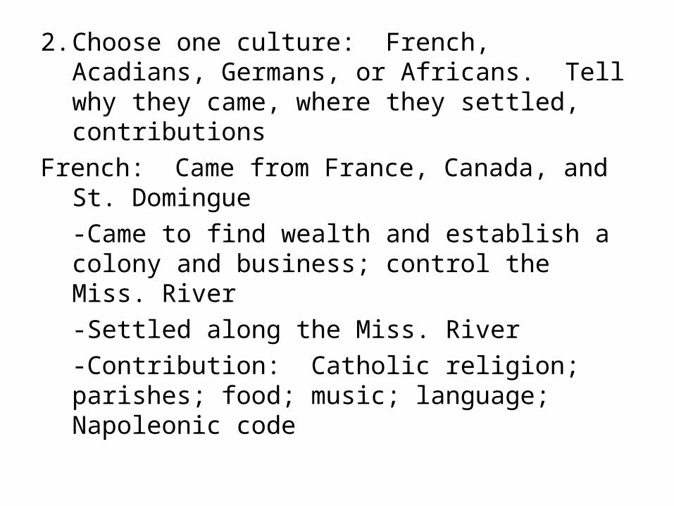
2. Choose one culture: French, Acadians, Germans, or Africans. Tell why they came, where they settled, contributions
French: Came from France, Canada, and St. Domingue
-Came to find wealth and establish a colony and business; control the Miss. River
-Settled along the Miss. River
-Contribution: Catholic religion; parishes; food; music; language; Napoleonic code

2. Choose one culture: French, Acadians, Germans, or Africans. Tell why they came, where they settled, contributions
Acadians: Came from Nova Scotia, Canada
-Exiled form homeland for refusing to take an oath of allegiance to British
-Contribution: Catholic religion; Cajun language and food; Cajun music with accordion, fishing and farming

2. Choose one culture: French, Acadians, Germans, or Africans. Tell why they came, where they settled, contributions
Germans: Came from German areas and Switzerland
-Left poverty and war; given free land
-Contribution: Farming, cooking; breweries
Settled: German Coast, St. John the Baptist, St. Charles, and St. James Parishes

2. Choose one culture: French, Acadians, Germans, or Africans. Tell why they came, where they settled, contributions
Africans: Came from West Africa and St. Domingo
-Slavery and later, fled slave revolt in St. Domingue
-Contribution: food, African dance and rhythms, Civil Rights, voodoo,
-settled along the Miss. River and New Orleans

Outline Map
Be able to identify:
Border states
4 natural borders (Pearl, Sabine, Miss. Gulf)
Draw path of Miss. River
Label Lakes Pontchartrain, Maurepas, Borgne
Label key cities: Shreveport, Monroe, Alexandria, Lake Charles, Lafayette, New Orleans, and Baton Rouge

Geography

1. Absolute location: tells where a point is on the Earth’s surface and why it is there
2. Relative location: tells us how far a point is from other points
3. Latitude: lines of measurement that measures the distance north and south
4. Longitude: lines of measurement that measure distance east and west
5. Prime Meridian: starting point for measuring longitude
6. Equator: starting point for measuring latitude

7. International Date Line: opposite of Prime Meridian that offsets time
8. Degree: unit of measurement9. Meandering streams: rivers that
wind their way back and forth10.Floodplains: flat valley floor
covered by excess water11.Point bars: sediment forms along
the inside of the meander

11.Point bars: sediment that forms in the meander of a stream cutting the curve
12.Deltas: landform shaped like a fan or a bird’s foot
13.Barrier islands: crescent-shaped island that forms after a river abandons its delta,
14.Coastal marshes: wet grasslands along the coast
15.Salt dome: parts of the sea that dried up

16.Cheniers: ridges of high ground in parallel to the coastline
17.Mississippi River: largest river in USA; over 2000 miles
18.Red River: northwest of state; high salt content
19.Atchafalaya River: A river that is a distributary of the Miss.; where the Miss would like to go
20.Bayou Teche: used to be part of the Miss. River; where Acadians settled

21. Bayou Lafourche: used to be part of the Miss. River
22. Oxbow lake: a lake left behind after a point bar cuts the curve of a river
23. Old River Control Structure: a structure used to divert ¼ of the Miss. River and all of the Red River into the Atchafalaya River
24. Morganza Spillway: River control system that sends flood waters to the Atchafalaya to relieve pressure on the Miss. River
25. Bonne Carre Spillway: diverts water to Lake Pontchartrain
26. J. Bennett Johnston: River control system located on the Red River

27.Flood of 1927: Caused from heavy rains and the Mississippi River breaking levees flooding the Miss. River delta
28. LA Wetlands: LA has over 1/3 of the nation’s wetlands

29.0 ° -90°30.0 ° -180 °31.180 ° 32.Increase33.Decrease34.Floodplains, uplands, coastal
marshes35.Plaquemines Parish36.Atchafalaya River37. Mississippi River’s large delta

38.They break, prevent sediment from depositing; prevent land from building
39.wall of water brought in by a hurricane that causes the most damage and deaths
40.Saltwater intrusion41. planting marsh grass, pumping sand,
closing canals, diversion projects
42.Buffer Louisiana from hurricanes; absorb storm surge
43.1 football field

44.Coastal erosion45.Take the path of least resistance
46.Miss. River delta; New Orleans and other places are below sea level; floodplain
47.Architecture, Food, Music, language48.Shotgun, Acadian, Spanish Colonial,
French Creole, American Greek Revival49.Cajun, Jazz, Zydeco50.Sportsman’s Paradise: Region’s inland
location, it was settled by different groups than the rest of LA

51.Acadians/Cajuns settled there along waterways
52.Cajuns
53.Accordion and fiddle
54.Slavery
55.Forced to leave Nova Scotia when they refused oath of allegiance to British

Economics
56.The study of the production, distribution, and consumption of goods and services
57.Citizens answer the four questions of economics; also known as capitalism and free enterprise
58. Government answers the four questions of economics; also known as communism

59.Tradition and beliefs answer the four questions of economics
60. Combination of market, command, and/or traditional
61.What you choose
62.What you give up
63.What is being produced?
How is it being produced?
How much is being produced?
Who is going to buy it?

64. Pay by the hour
65.a fixed amount of pay
66. amount of goods
67. how bad do you want goods/services
68. See Flow chart
69.Land, labor, capital
70.Rent, interest, wages, and dividends
71.Shortage; limited amount of a good

• Know where major rivers, bayous, and lakes are in Louisiana