Embed Size (px)
Citation preview
1
SHARAD U.S. Team Member Investigations
Roger Phillips (Deputy Team Leader) — Washington Univ.
Bruce Campbell — National Air & Space Museum (SI)
Jeffrey Plaut — Jet Propulsion Laboratory
MRO PSG — 12/06/01
The primary objective of the SHARAD experiment is to map, in selected locales, dielectric interfaces to several hundred meters depth in the martian subsurface and to interpret these results in terms of the occurrence and distribution of expected materials, including competent rock, regolith, water and ice.
2
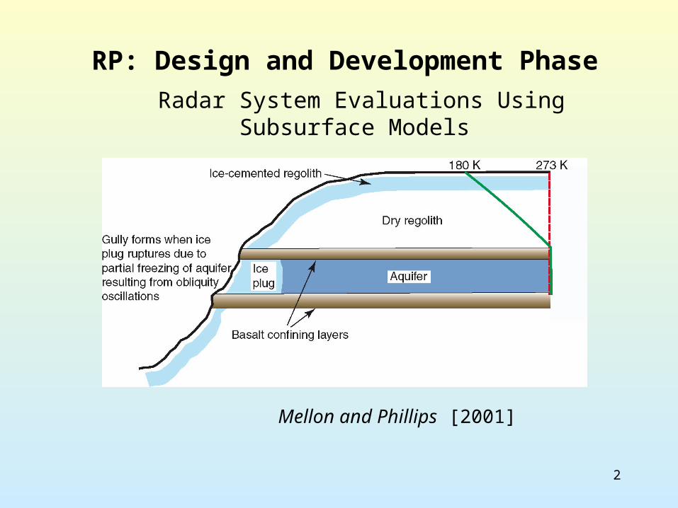
RP: Design and Development Phase
Mellon and Phillips [2001]
Radar System Evaluations Using Subsurface Models
3
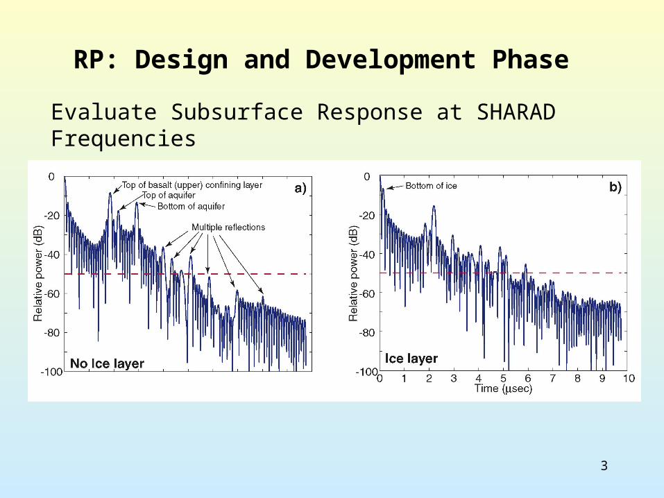
RP: Design and Development Phase
Evaluate Subsurface Response at SHARAD Frequencies

4
RP: Design and Development PhaseEvaluate Dynamic Range in Light of Loss Mechanisms
Loss due to metallic minerals Loss due to 10% volume scattering
5
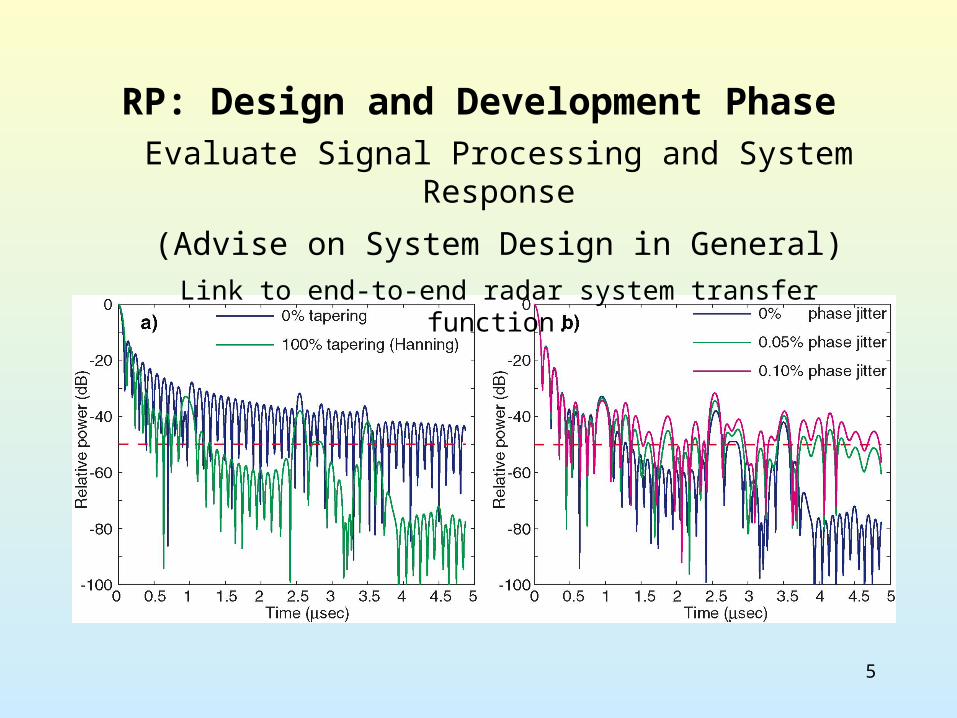
RP: Design and Development PhaseEvaluate Signal Processing and System Response
(Advise on System Design in General)
Link to end-to-end radar system transfer function.
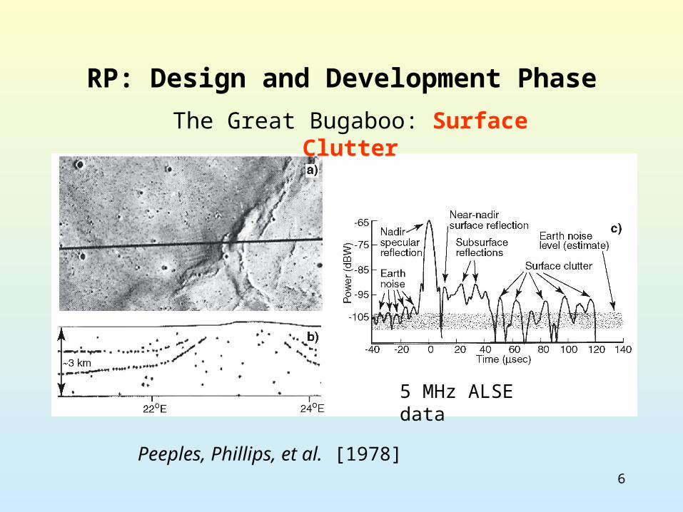
6
RP: Design and Development Phase
Peeples, Phillips, et al. [1978]
The Great Bugaboo: Surface Clutter
5 MHz ALSE data
7
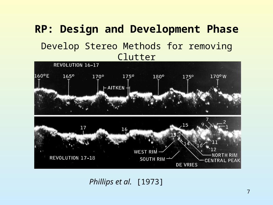
RP: Design and Development Phase
Phillips et al. [1973]
Develop Stereo Methods for removing Clutter
8
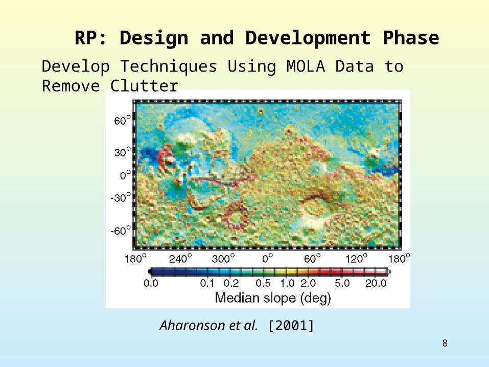
RP: Design and Development Phase
Aharonson et al. [2001]
Develop Techniques Using MOLA Data to Remove Clutter
9
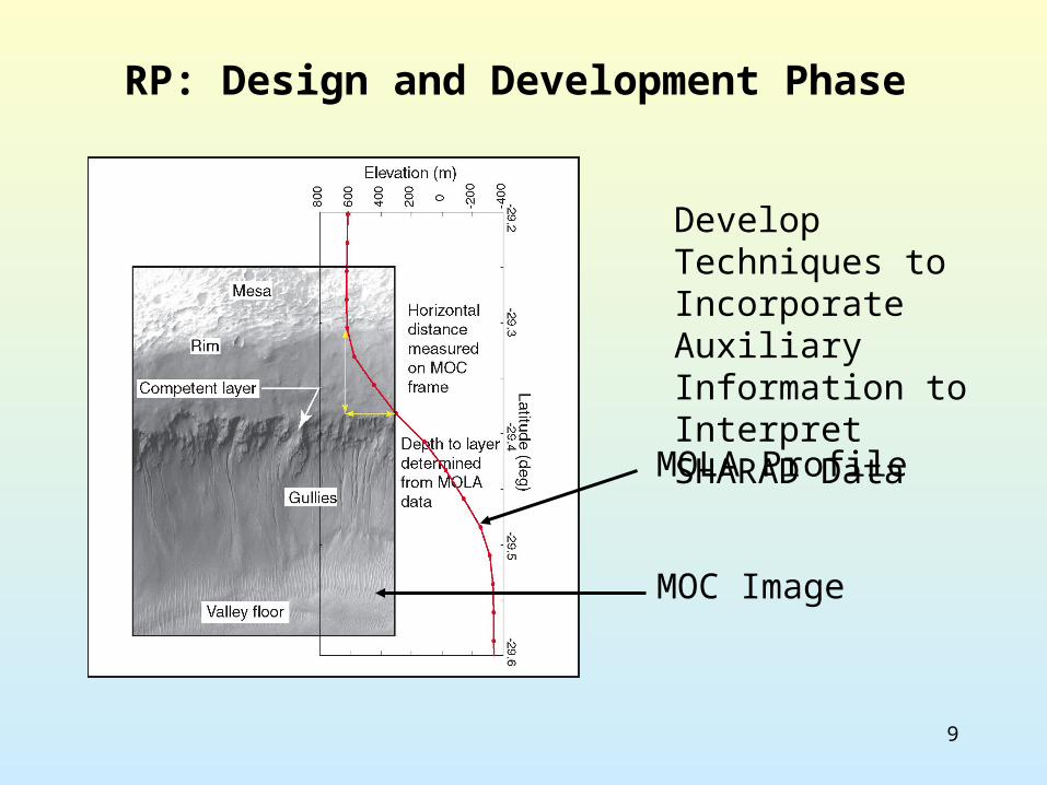
RP: Design and Development Phase
Develop Techniques to Incorporate Auxiliary Information to Interpret SHARAD Data
MOLA Profile
MOC Image
10
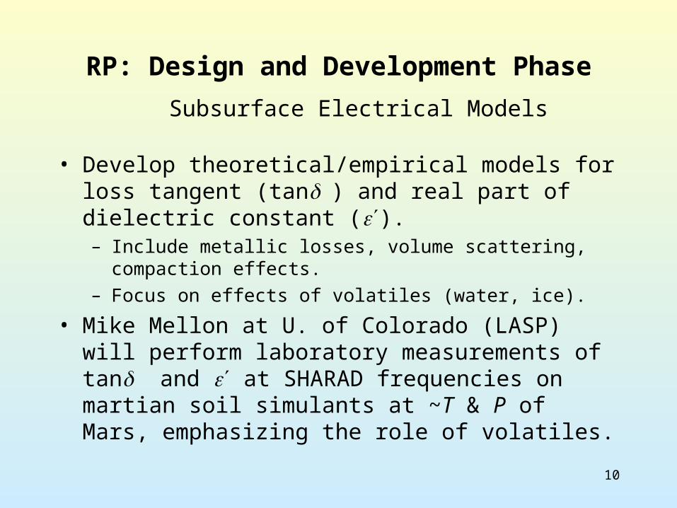
RP: Design and Development Phase
• Develop theoretical/empirical models for loss tangent (tan) and real part of dielectric constant ().– Include metallic losses, volume scattering, compaction
effects.– Focus on effects of volatiles (water, ice).
• Mike Mellon at U. of Colorado (LASP) will perform laboratory measurements of tan and at SHARAD frequencies on martian soil simulants at ~T & P of Mars, emphasizing the role of volatiles.
Subsurface Electrical Models
11
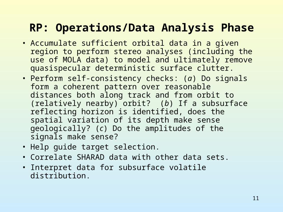
RP: Operations/Data Analysis Phase• Accumulate sufficient orbital data in a given region to
perform stereo analyses (including the use of MOLA data) to model and ultimately remove quasispecular deterministic surface clutter.
• Perform self-consistency checks: (a) Do signals form a coherent pattern over reasonable distances both along track and from orbit to (relatively nearby) orbit? (b) If a subsurface reflecting horizon is identified, does the spatial variation of its depth make sense geologically? (c) Do the amplitudes of the signals make sense?
• Help guide target selection.• Correlate SHARAD data with other data sets.• Interpret data for subsurface volatile distribution.
12
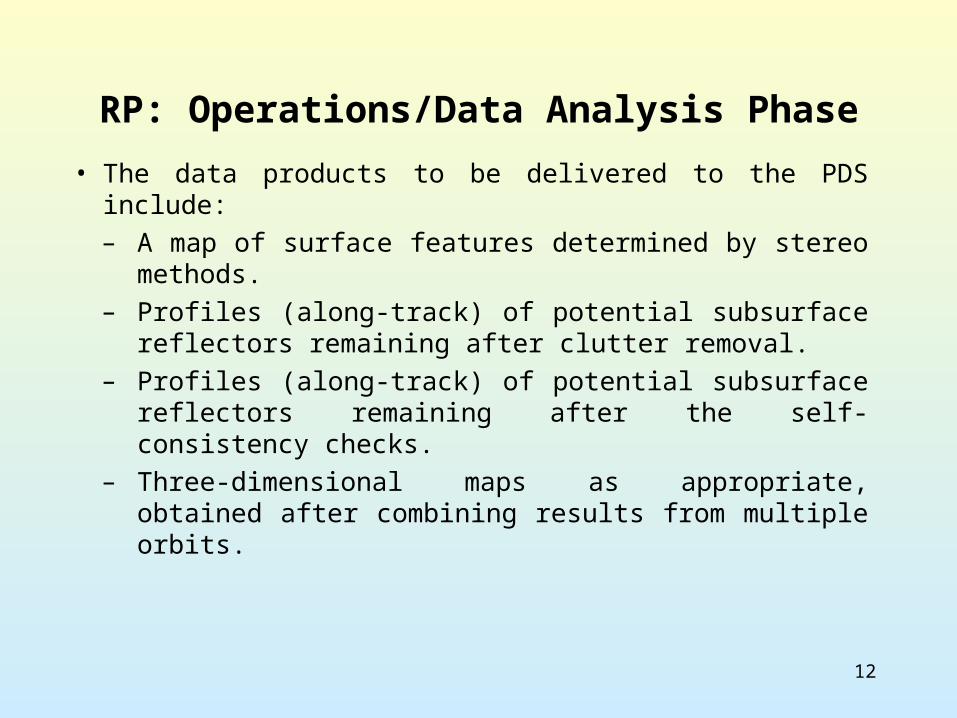
RP: Operations/Data Analysis Phase
• The data products to be delivered to the PDS include: – A map of surface features determined by stereo
methods. – Profiles (along-track) of potential subsurface
reflectors remaining after clutter removal. – Profiles (along-track) of potential subsurface
reflectors remaining after the self-consistency checks.
– Three-dimensional maps as appropriate, obtained after combining results from multiple orbits.
13
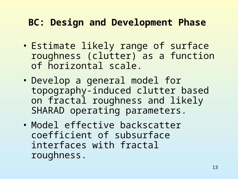
BC: Design and Development Phase
• Estimate likely range of surface roughness (clutter) as a function of horizontal scale.
• Develop a general model for topography-induced clutter based on fractal roughness and likely SHARAD operating parameters.
• Model effective backscatter coefficient of subsurface interfaces with fractal roughness.
14
BC: Design and Development Phase
• Evaluate likely range of material properties (tan, ).
• Re-analysis of ALSE 15 MHz data and Arecibo 7.5-m lunar map for guidance in SHARAD design and operation.
• Assessment of operating frequency(ies) and clutter reduction plans based on physical surface properties and past experimental results.
15
BC: Operations/Data Analysis Phase
• Selection of optimum clutter reduction method.
• Selection of regions for repeat observations.
• Optimizing data collection based on early results.
• Data validation and archiving requirements.
• Public outreach through museum programs.

16
• Apply “lessons learned” from MARSIS, and ensure that the two experiments are carried out in a complementary and synergistic fashion.
• Assist in trade studies that will determine the critical choices of radar frequency(ies), operating bandwidth, and onboard processing capabilities.
• Understand the trade-off between high frequency/high resolution measurements, and the effects of surface clutter.
JP: Design and Development Phase
17
• Define the science and measurement requirements, and their traceability, for the SHARAD at the earliest stages of the design phase.
• Define the data products that will be most useful to the Team and the science community at large.
• Definition of processing algorithms and user data analysis software.
JP: Design and Development Phase
18
• Work with the other payloads on MRO to ensure that all science investigations achieve their goals in an integrated science operations plan.
• Establish a U.S. operational and data analysis base to support and augment the primary operations facility that will likely be in Europe.
• Targeting, mode selection, onboard processing, etc.
• Selecting targets for detailed study based on data acquired by MARSIS and other instruments on previous and ongoing missions.
JP: Operations Phase
19
• Conduct integrated analyses of other remote sensing data sets, such as MOLA and HRSC (Mars Express stereo) derived surface topography, geochemical and thermal data (e.g., TES, THEMIS, CRISM) and the vast catalogue of image data to understand the geologic significance of any detected subsurface interfaces.
• Calibration, including cross-comparison of MARSIS and SHARAD backscatter measurements, to see if the expected frequency-dependent behavior is observed.
JP: Data Analysis Phase
20
• Characterization of subsurface interfaces that are not a direct result of the presence of water or ice, such as volcanic layering, sedimentary deposits including mobile material (sand sheets, dunes, dust mantles) and fault contacts.
• Use SHARAD data to further explore the history and climatic significance of the polar deposits.
JP: Data Analysis Phase
21
• Ensure that all data products are of the highest quality and are released to the community in a timely fashion.
• Pursue the development and/or implementation of Web-based tools that allow users to access SHARAD data in concert with other data sets, such as MARSIS and MOLA.
JP: Data Archiving and Distribution Phase

22
23
BC: Possible Mars Dielectric/Magnetic Properties
• For dry materials, ~1.96, tan modulated by Fe and Ti content and mineral state - lunar basalt tan modulated almost entirely by ilmenite, not by FeO in other minerals.
• For brines, ~80; no effective penetration.
• For ice, ~3.2, tan modulated by included fines.
• Magnetic permeability of martian materials unknown.
24
BC: Mars Surface Roughness
• Landing site topography consistent with self-affine roughness, with nearly Brownian scaling of rms height: ho(L)~ho(Lo)(L/Lo)0.5.
• Fractal scaling may be used to infer surface clutter potential as a function of radar wavelength and illuminated area. Global estimates of clutter potential tied only to roughness measured by MOLA (relevant to the few-meter scale?).
• Near-nadir radar echoes from the surface and subsurface may also be modeled using fractal roughness description (better link to true topography than given by Hagfors’ model).


![Sharad Choudhary Sip Report[1]](https://img.pdfslide.us/doc/110x75/577d275f1a28ab4e1ea3c09a/sharad-choudhary-sip-report1.jpg)