Embed Size (px)
Citation preview

1
Service Chaining of Interoperable Geographic Information Web Services By
Nadine Alameh Global Science & Technology
6411 Ivy Lane Suite 300, Greenbelt, MD 20770 [email protected]
Keywords: Web services, service chaining, distributed GIS, GIS evolution
2
Service Chaining of Interoperable Geographic Information Web Services
This paper is based on the evolution of Geographic Information Systems towards
the web services model. Indeed, this model is rapidly materializing as a result of the
advancements in general web service technologies and the focused efforts of the Open
GIS Consortium in the areas of service categorization and interoperability of service
interfaces. This paper focuses on the issues of service chaining, the process of combining
or pipelining results from several complementary and interoperable GIS Web Services to
create a customized solution. The paper presents three basic service chaining options:
client-coordinated, static and mediated chaining. Each option is examined with respect to
its coordination complexity, metadata tracking ability and error handling propagation.
The paper highlights the middleware requirements specific to working with GIS services.
The paper concludes with a discussion on the potential changes in the GIS marketplace
given a successful deployment and chaining of GIS Web Services.
3
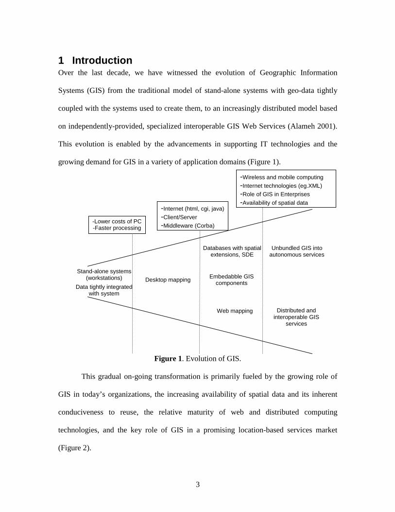
1 Introduction Over the last decade, we have witnessed the evolution of Geographic Information
Systems (GIS) from the traditional model of stand-alone systems with geo-data tightly
coupled with the systems used to create them, to an increasingly distributed model based
on independently-provided, specialized interoperable GIS Web Services (Alameh 2001).
This evolution is enabled by the advancements in supporting IT technologies and the
growing demand for GIS in a variety of application domains (Figure 1).
Figure 1. Evolution of GIS.
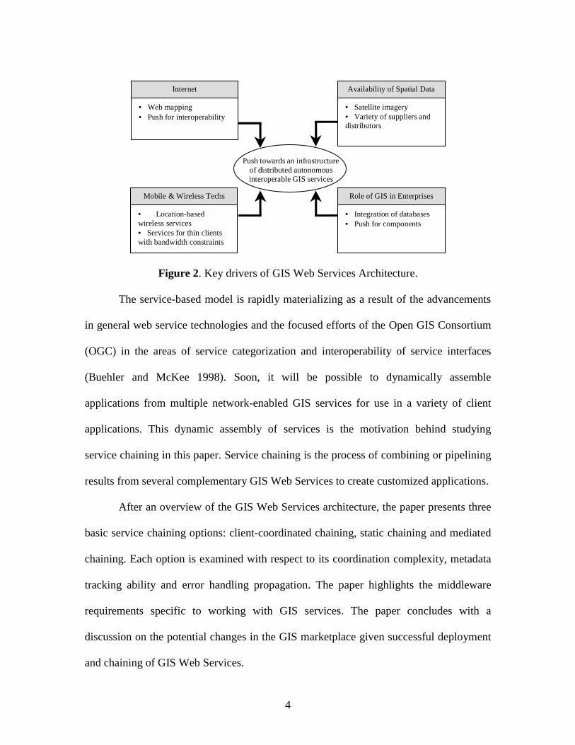
This gradual on-going transformation is primarily fueled by the growing role of
GIS in today’s organizations, the increasing availability of spatial data and its inherent
conduciveness to reuse, the relative maturity of web and distributed computing
technologies, and the key role of GIS in a promising location-based services market
(Figure 2).
Stand-alone systems (workstations)
Data tightly integrated with system
Desktop mapping
Databases with spatial extensions, SDE
Embedabble GIS components
Web mapping
Unbundled GIS into autonomous services
Distributed and interoperable GIS
services
-Lower costs of PC -Faster processing
-Internet (html, cgi, java)
-Client/Server
-Middleware (Corba)
-Wireless and mobile computing
-Internet technologies (eg.XML)
-Role of GIS in Enterprises
-Availability of spatial data
4
• Satellite imagery• Variety of suppliers anddistributors
Availability of Spatial Data
• Web mapping• Push for interoperability
Internet
• Integration of databases• Push for components
Role of GIS in Enterprises
• Location-basedwireless services• Services for thin clientswith bandwidth constraints
Mobile & Wireless Techs
Push towards an infrastructureof distributed autonomousinteroperable GIS services
Figure 2. Key drivers of GIS Web Services Architecture.
The service-based model is rapidly materializing as a result of the advancements
in general web service technologies and the focused efforts of the Open GIS Consortium
(OGC) in the areas of service categorization and interoperability of service interfaces
(Buehler and McKee 1998). Soon, it will be possible to dynamically assemble
applications from multiple network-enabled GIS services for use in a variety of client
applications. This dynamic assembly of services is the motivation behind studying
service chaining in this paper. Service chaining is the process of combining or pipelining
results from several complementary GIS Web Services to create customized applications.
After an overview of the GIS Web Services architecture, the paper presents three
basic service chaining options: client-coordinated chaining, static chaining and mediated
chaining. Each option is examined with respect to its coordination complexity, metadata
tracking ability and error handling propagation. The paper highlights the middleware
requirements specific to working with GIS services. The paper concludes with a
discussion on the potential changes in the GIS marketplace given successful deployment
and chaining of GIS Web Services.
5
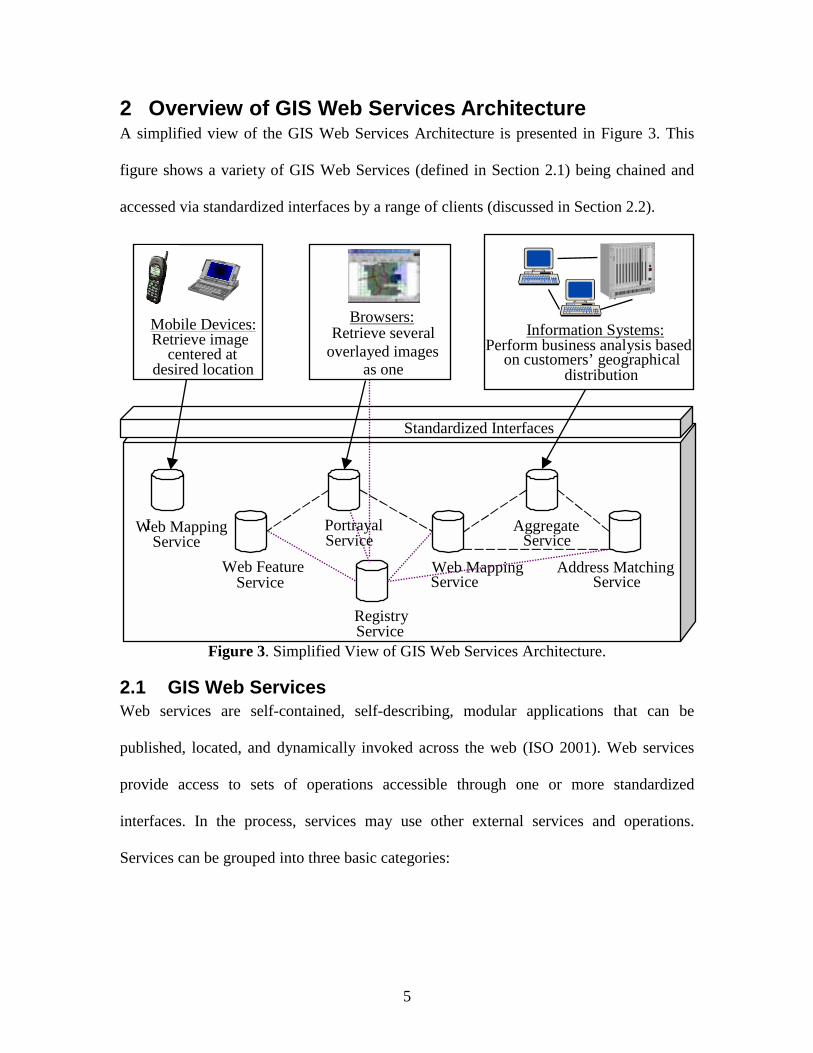
2 Overview of GIS Web Services Architecture A simplified view of the GIS Web Services Architecture is presented in Figure 3. This
figure shows a variety of GIS Web Services (defined in Section 2.1) being chained and
accessed via standardized interfaces by a range of clients (discussed in Section 2.2).
Figure 3. Simplified View of GIS Web Services Architecture.
2.1 GIS Web Services Web services are self-contained, self-describing, modular applications that can be
published, located, and dynamically invoked across the web (ISO 2001). Web services
provide access to sets of operations accessible through one or more standardized
interfaces. In the process, services may use other external services and operations.
Services can be grouped into three basic categories:
Mobile Devices: Retrieve image
I Web Mapping Service
Web Feature Service
Portrayal Service
Web Mapping Service
Aggregate Service
Address Matching Service
centered at desired location
Browsers: Retrieve several
overlayed images as one
Standardized Interfaces
Information Systems:
distribution
Registry Service
Perform business analysis based on customers’ geographical
6
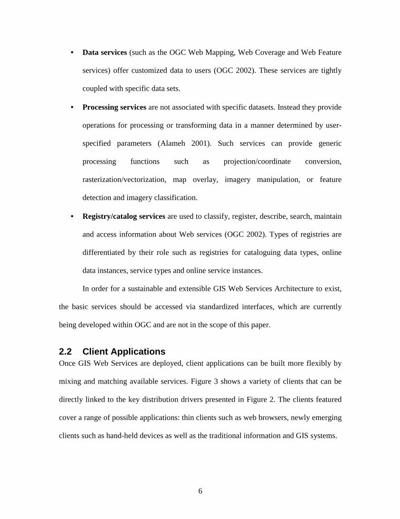
• Data services (such as the OGC Web Mapping, Web Coverage and Web Feature
services) offer customized data to users (OGC 2002). These services are tightly
coupled with specific data sets.
• Processing services are not associated with specific datasets. Instead they provide
operations for processing or transforming data in a manner determined by user-
specified parameters (Alameh 2001). Such services can provide generic
processing functions such as projection/coordinate conversion,
rasterization/vectorization, map overlay, imagery manipulation, or feature
detection and imagery classification.
• Registry/catalog services are used to classify, register, describe, search, maintain
and access information about Web services (OGC 2002). Types of registries are
differentiated by their role such as registries for cataloguing data types, online
data instances, service types and online service instances.
In order for a sustainable and extensible GIS Web Services Architecture to exist,
the basic services should be accessed via standardized interfaces, which are currently
being developed within OGC and are not in the scope of this paper.
2.2 Client Applications Once GIS Web Services are deployed, client applications can be built more flexibly by
mixing and matching available services. Figure 3 shows a variety of clients that can be
directly linked to the key distribution drivers presented in Figure 2. The clients featured
cover a range of possible applications: thin clients such as web browsers, newly emerging
clients such as hand-held devices as well as the traditional information and GIS systems.
7
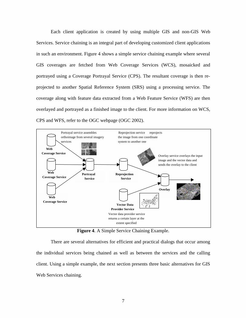
Each client application is created by using multiple GIS and non-GIS Web
Services. Service chaining is an integral part of developing customized client applications
in such an environment. Figure 4 shows a simple service chaining example where several
GIS coverages are fetched from Web Coverage Services (WCS), mosaicked and
portrayed using a Coverage Portrayal Service (CPS). The resultant coverage is then re-
projected to another Spatial Reference System (SRS) using a processing service. The
coverage along with feature data extracted from a Web Feature Service (WFS) are then
overlayed and portrayed as a finished image to the client. For more information on WCS,
CPS and WFS, refer to the OGC webpage (OGC 2002).
Figure 4. A Simple Service Chaining Example.
There are several alternatives for efficient and practical dialogs that occur among
the individual services being chained as well as between the services and the calling
client. Using a simple example, the next section presents three basic alternatives for GIS
Web Services chaining.
Reprojection Service
Web Coverage Service
Web Coverage Service
Portrayal Service
Portrayal service assembles orthoimage from several imagery services
Reprojection service reprojects the image from one coordinate system to another one
Vector Data Provider Service
Vector data provider service returns a certain layer at the
extent specified
Overlay
Overlay service overlays the input image and the vector data and sends the overlay to the client
Web Coverage Service
8
3 Service Chaining
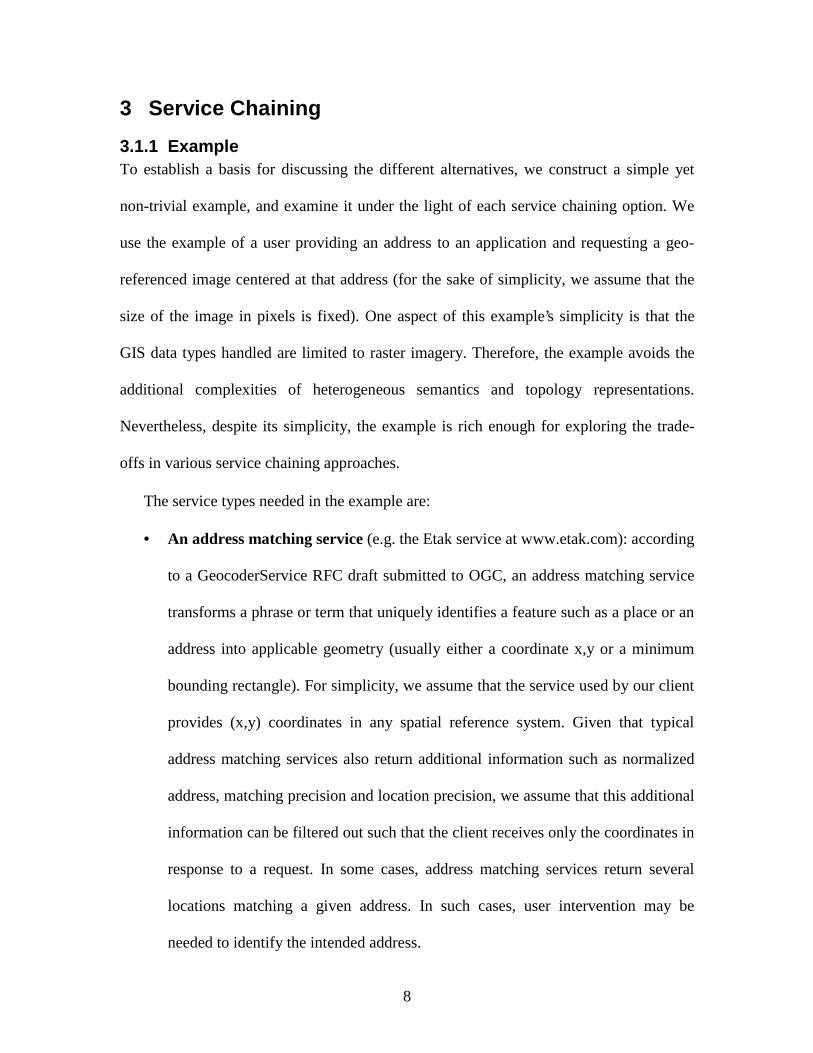
3.1.1 Example To establish a basis for discussing the different alternatives, we construct a simple yet
non-trivial example, and examine it under the light of each service chaining option. We
use the example of a user providing an address to an application and requesting a geo-
referenced image centered at that address (for the sake of simplicity, we assume that the
size of the image in pixels is fixed). One aspect of this example’s simplicity is that the
GIS data types handled are limited to raster imagery. Therefore, the example avoids the
additional complexities of heterogeneous semantics and topology representations.
Nevertheless, despite its simplicity, the example is rich enough for exploring the trade-
offs in various service chaining approaches.
The service types needed in the example are:
• An address matching service (e.g. the Etak service at www.etak.com): according
to a GeocoderService RFC draft submitted to OGC, an address matching service
transforms a phrase or term that uniquely identifies a feature such as a place or an
address into applicable geometry (usually either a coordinate x,y or a minimum
bounding rectangle). For simplicity, we assume that the service used by our client
provides (x,y) coordinates in any spatial reference system. Given that typical
address matching services also return additional information such as normalized
address, matching precision and location precision, we assume that this additional
information can be filtered out such that the client receives only the coordinates in
response to a request. In some cases, address matching services return several
locations matching a given address. In such cases, user intervention may be
needed to identify the intended address.
9
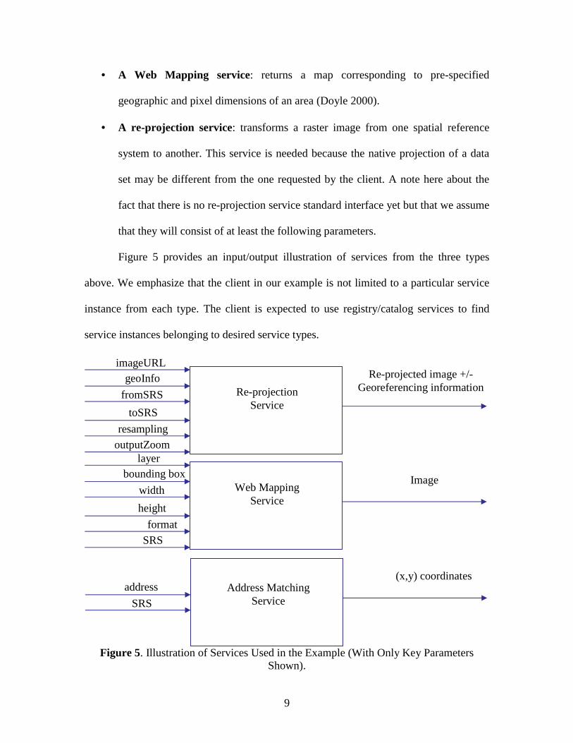
• A Web Mapping service: returns a map corresponding to pre-specified
geographic and pixel dimensions of an area (Doyle 2000).
• A re-projection service: transforms a raster image from one spatial reference
system to another. This service is needed because the native projection of a data
set may be different from the one requested by the client. A note here about the
fact that there is no re-projection service standard interface yet but that we assume
that they will consist of at least the following parameters.
Figure 5 provides an input/output illustration of services from the three types
above. We emphasize that the client in our example is not limited to a particular service
instance from each type. The client is expected to use registry/catalog services to find
service instances belonging to desired service types.
Figure 5. Illustration of Services Used in the Example (With Only Key Parameters
Shown).
Re-projection Service
imageURL geoInfo
fromSRS
toSRS
resampling
outputZoom
Re-projected image +/- Georeferencing information
layer
Web Mapping Service
bounding box
width
height
format
SRS
Image
Address Matching Service
address
SRS
(x,y) coordinates
10
For the sake of simplicity, we assume that the authentication of the client by the
services can be handled using available authentication technologies, such as Kerberos,
cookies or basic http authentication. Similarly, we assume billing for services and data
can be managed using current e-commerce related approaches, such as Ecash
(www.ecash.com), CyberCash (www.cybercash.com) or PayPal (www.paypal.com).
3.2 Key Analysis Issues There is a wide range of issues surrounding the design of a scalable and extensible
geospatial infrastructure based on service chaining. The key is to address the issues of
service chaining and coordination without compromising performance and scalability of
the infrastructure. In this section, we focus on a subset of these issues. This subset covers
• The degree of transparency to the client of the service chaining complexities and
the amount of coordination responsibility required by the client to construct,
execute and manage service chains.
• The alternatives for keeping track and relaying to the client the sources of data
used in a service chain and the transformations that were applied to them along
the chain. Keeping track of metadata may be especially important in cases where
service chaining is hidden from the client.
• The alternatives for handling and reporting errors along a chain to the client. This
may be regarded as a special case of metadata tracking. Precise error reporting is
needed by clients in the cases when one or more services along a chain break or
issue a certain type of exception.
11
The service chaining described in Section 3.1 is used to pinpoint issues of complexity of
dialogs and the implications of service chaining on the client’s thickness and intelligence
requirements.
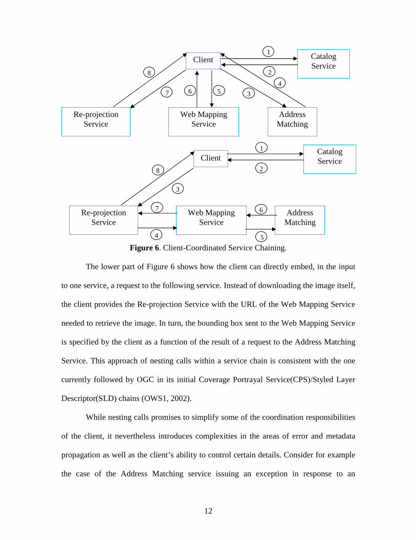
3.2.1 Client-Coordinated Service Chaining In the simplest case, service chaining is fully transparent to the client: The client defines
and controls the order of execution of individual services in a chain. The client also must
have prior knowledge of the interfaces, inputs and outputs of the services or service types
it is using. In the upper part of Figure 6, the client first searches a Catalog to find service
instances to use (Nebert 1999). A service instance for each service type needed is
returned. The client then uses the Address Matching Service to find the coordinates of the
address requested by the user. The coordinates (along with other parameters) are sent to a
Web Mapping Service which returns an image to the client. If the image returned is in a
different SRS than the one used by the client, it is then re-projected by a Re-projection
Service (the client may access the registry service again to find a Re-projection Service
instance). In this case, the client is handling all intermediate results returned by the
services in the chain.
12
Figure 6. Client-Coordinated Service Chaining.
The lower part of Figure 6 shows how the client can directly embed, in the input
to one service, a request to the following service. Instead of downloading the image itself,
the client provides the Re-projection Service with the URL of the Web Mapping Service
needed to retrieve the image. In turn, the bounding box sent to the Web Mapping Service
is specified by the client as a function of the result of a request to the Address Matching
Service. This approach of nesting calls within a service chain is consistent with the one
currently followed by OGC in its initial Coverage Portrayal Service(CPS)/Styled Layer
Descriptor(SLD) chains (OWS1, 2002).
While nesting calls promises to simplify some of the coordination responsibilities
of the client, it nevertheless introduces complexities in the areas of error and metadata
propagation as well as the client’s ability to control certain details. Consider for example
the case of the Address Matching service issuing an exception in response to an
Address Matching
Web Mapping Service
Re-projection Service
Client Catalog Service
Address Matching
Web Mapping Service
Re-projection Service
Client Catalog Service
2
3
4 5 6 7
8
1
2
3
6 7
8
1
4 5
13
erroneous call from the client. To the Web Mapping Service in the lower part of Figure 6,
this exception is viewed as an invalid input, triggering the Web Mapping Service to
signal an "invalid input" exception. A domino effect ensues, as the same problem occurs
over the Web Mapping/re-projection link, forcing the Re-projection Service to signal its
own "invalid input" exception (this time to the client). Although the client is eventually
informed of the occurrence of an exception in the chain, the actual exception received by
the client does not disclose information about the source or the cause of that exception.
One way to overcome this limitation is to allow a service to automatically forward a
received exception input, as is, to the next service in the chain; while appending to the
forwarded exception any of the service’s own error messages. In this context,
representing exceptions in XML is particularly useful as it makes it easier for services to
detect and add to incoming exceptions.
This approach of relaying exceptions to the client can be extended to handle
metadata propagation. One example of metadata is information about billing from
individual services. Metadata can be appended to normal data as it is passed between
services. However, for services to process and exchange documents containing both the
data and its metadata, a standard is required.
Finally, consider the issue of an unexpected delay occurrence in one of the
services in a chain. The serial nature of the chain implies that the delay propagates
through the chain, and all the way to the client. In the scenario where the client directly
accesses each service, the client can abort the operation if a specified time-out period for
a service expires. In that case, the client can opt for a substitute for the timed-out service.
However, with nested calls, a global time-out is needed. This time-out is controlled by
14
the client and may be communicated to every service in the chain. At any point, if a
service takes longer than this global time-out, it aborts and returns an appropriate
exception to the preceding service in the chain. The efficiency of chains can be further
improved through data compression. Compressing data decreases transmission time,
although it may be at the expense of increasing the processing time at the services.
The above analysis illustrates how client-coordinated service chaining in a
decentralized setting requires deep involvement of the client. Although the coordination
responsibilities of the client may be alleviated by simple interoperable service interfaces,
it is not unlikely that they will hinder a wide-base adoption of the GIS Web Services
model. The next section introduces static chaining by aggregate services as a service
chaining alternative which hides all service chaining complexities from the client.
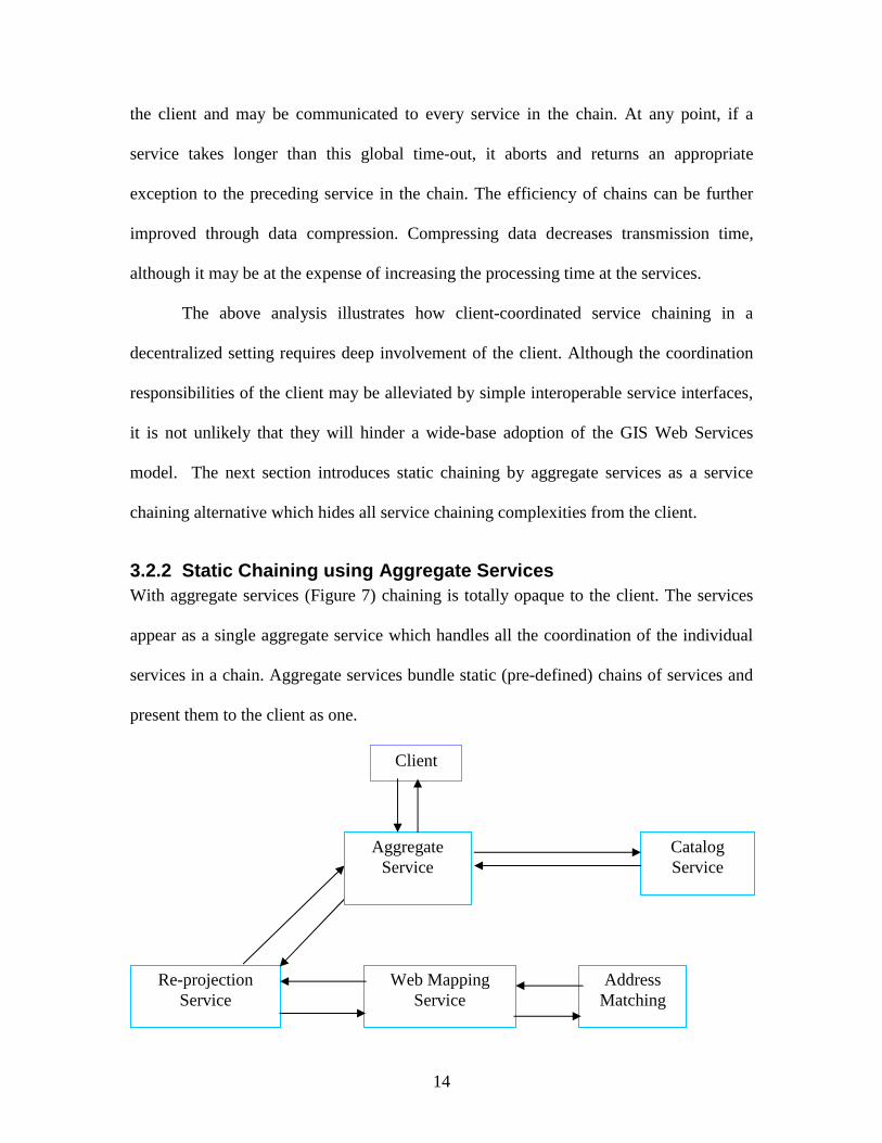
3.2.2 Static Chaining using Aggregate Services With aggregate services (Figure 7) chaining is totally opaque to the client. The services
appear as a single aggregate service which handles all the coordination of the individual
services in a chain. Aggregate services bundle static (pre-defined) chains of services and
present them to the client as one.
Address Matching
Web Mapping Service
Re-projection Service
Client
Catalog Service
Aggregate Service
15
Figure 7. Static Chaining with Aggregate Services.
Despite their benefits, aggregate services have some drawbacks. By having a
single access point to the chain, the client loses some of the flexibility and control over
parameters of the individual services. In the example, the client has no control over the
re-projection step. In fact, the client may not even be aware that the image is being re-
projected. The invisibility of this step and the assumptions made by the aggregate service
can be misleading to some clients. For this reason, clients should be able to differentiate
between basic and aggregate services, which is why within OGC, service descriptions (or
capabilities files) include a flag that indicates whether a service is an aggregate
(cascading) service.
Fortunately, there is a more flexible and scalable alternative to aggregate services
in a distributed environment where static binding of services and calls is often not
efficient. The next alternative introduces workflow-managed service chaining with
mediating services, which aims at achieving a balance between the totally transparent
client-coordinated chaining and the totally opaque aggregate services chaining.
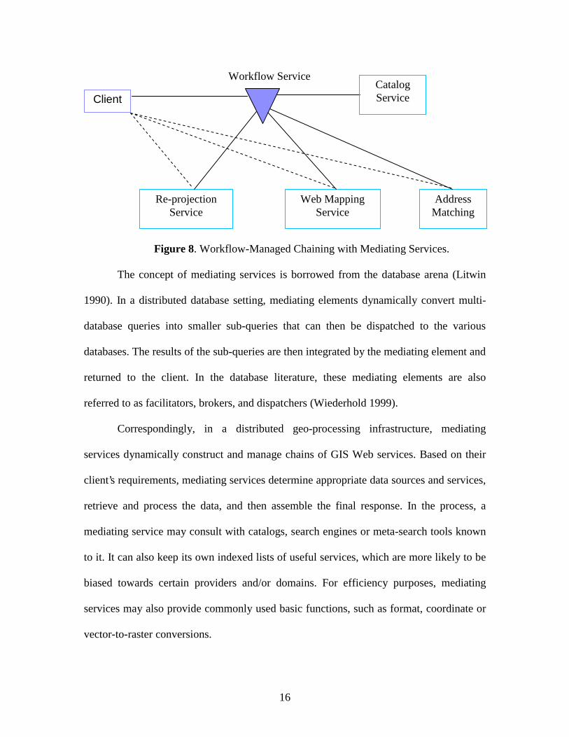
3.2.3 Workflow-Managed Service Chaining with Mediating Services As seen in Figure 8, mediating services act as gateways to other services by coordinating
between multiple services without necessarily storing any data of their own. Mediating
services combine the simplicity of aggregate services with the flexibility and control
inherent in client-coordinated service chaining. The client may execute the chain himself
or just select a chain to be executed by the mediating service.
16
Figure 8. Workflow-Managed Chaining with Mediating Services.
The concept of mediating services is borrowed from the database arena (Litwin
1990). In a distributed database setting, mediating elements dynamically convert multi-
database queries into smaller sub-queries that can then be dispatched to the various
databases. The results of the sub-queries are then integrated by the mediating element and
returned to the client. In the database literature, these mediating elements are also
referred to as facilitators, brokers, and dispatchers (Wiederhold 1999).
Correspondingly, in a distributed geo-processing infrastructure, mediating
services dynamically construct and manage chains of GIS Web services. Based on their
client’s requirements, mediating services determine appropriate data sources and services,
retrieve and process the data, and then assemble the final response. In the process, a
mediating service may consult with catalogs, search engines or meta-search tools known
to it. It can also keep its own indexed lists of useful services, which are more likely to be
biased towards certain providers and/or domains. For efficiency purposes, mediating
services may also provide commonly used basic functions, such as format, coordinate or
vector-to-raster conversions.
Client
Address Matching
Web Mapping Service
Re-projection Service
Workflow Service Catalog Service
17
Mediating services use pre-specified client preferences to search for appropriate
data and processing services that best meet their clients’ requirements. Such preferences
might include information about service time-outs, price ceilings, accuracy requirements,
and maximum number of services chained. In some cases, the client may also wish to
specify a preference for a particular service provider. The client may also impose a
constraint that all services used in a particular session be supplied by the same provider,
presumably to achieve certain efficiencies as well as monetary savings.
Mediating services can be considered as specialized versions of existing workflow
and process management tools. The need for specialization is a consequence of the
distinctive characteristics of GIS (Alameh 2001), especially the semantics associated with
GIS data and the complexity of spatial queries. With the wide range of possible GIS
applications and the different semantics needed in different fields, it is more likely that
the internal mediating service rules will be tuned to specific application domains.
Therefore, in terms of market dynamics, we foresee the emergence of a variety of
mediating service providers, which range in their "smarts" as well as the nature of their
specialization. The need for domain-tuned services will constitute excellent market entry
opportunities for third party players with significant expertise in a certain domain, but
with no capabilities to single-handedly offer and maintain all the data and transformations
needed for that domain.
As the number of services and catalogs available in an environment grows, there
will be an increasing need for more sophisticated search-engine-like tools that can
consolidate, organize and present information retrieved from various sources. Such tools
may also provide interfaces through which users can pick services they need. Such tools
18
can dispatch the users’ requests to a variety of available catalogs, and then allow users to
sort the results according to different criteria, e.g., price, quality or provider. As such,
these tools are similar to popular online price comparison sites (e.g., metaprices.com or
simon.com) which allow users to pick a category of items to compare (e.g., cds, books,
electronics) and then return a list of items along with their prices, availability, special
offers and reviews from various online shopping websites.
In summary, mediating services promise to minimize the complexity of service
chaining while providing clients with solutions that are specifically tuned to their
preferences. Mediating services also provide a client with a single point of contact for
accounting and authentication, as well as error and metadata reporting.
4 Conclusion It is becoming increasingly evident that there is a growing need for a GIS Web Services
architecture (Abel D, Ooi B, Tan K, and Tan S 1998). This architecture will be especially
beneficial for scientific research and engineering modeling as well as state and federal
government settings, where tightly coupled hierarchical systems are unlikely to provide
the desired breadth and flexibility. The web services model allows users in these settings
to freely combine services to create customized solutions with minimal programming,
integration and maintenance efforts. Such a model will also be a key enabler of GIS to
extend beyond its traditional boundaries of mapping to embrace a broader community of
users and wider scope of services. Critical to the success and sustainability of the
distributed Web Services architecture is the issue of service chaining. After examining
three service chaining options (client-coordinated, static and workflow-managed), we
conclude that workflow-managed service chaining with mediating services combines the
19
simplicity of static chaining with the flexibility and control of client-coordinated
chaining.
Enabled by the advancements in web services in general, and by the on-going
work of subgroups within OGC, the GIS Web Services architecture is rapidly manifesting
itself. Various groups within OGC are working on service categorization (data,
processing and registry services), encodings (SLD, GML), and service chaining
(WMS/SLD/CPS, which is setting a precedent for service chaining in the web services
environment). Within this work, general web services technologies have been critical:
examples include WSDL for service description, UDDI for service discovery, SOAP for
passing XML-encoded data, and IBM WSFL and MS XLANG for web service
composition and process languages for orchestrating web services (OWS1 2002).
The next section provides some insights on how the GIS marketplace may be
changing in the near future as a result of such advancements.
4.1 A Changing GIS MarketPlace The unbundling of GIS systems into independently-provided interoperable components,
and the delivery of subsets of GIS data to users on demand will lead to significant
changes in the GIS marketplace. Figure 9 outlines a potential value chain for the future
GIS marketplace.
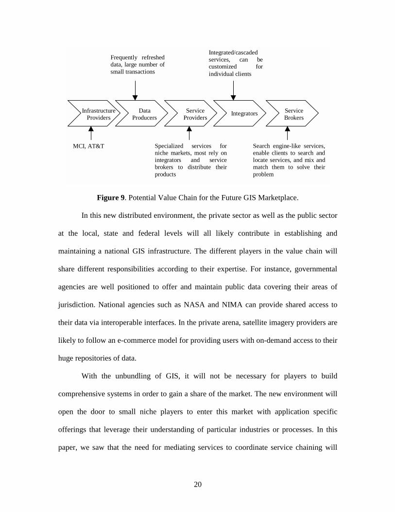
20
Figure 9. Potential Value Chain for the Future GIS Marketplace.
In this new distributed environment, the private sector as well as the public sector
at the local, state and federal levels will all likely contribute in establishing and
maintaining a national GIS infrastructure. The different players in the value chain will
share different responsibilities according to their expertise. For instance, governmental
agencies are well positioned to offer and maintain public data covering their areas of
jurisdiction. National agencies such as NASA and NIMA can provide shared access to
their data via interoperable interfaces. In the private arena, satellite imagery providers are
likely to follow an e-commerce model for providing users with on-demand access to their
huge repositories of data.
With the unbundling of GIS, it will not be necessary for players to build
comprehensive systems in order to gain a share of the market. The new environment will
open the door to small niche players to enter this market with application specific
offerings that leverage their understanding of particular industries or processes. In this
paper, we saw that the need for mediating services to coordinate service chaining will
InfrastructureProviders
DataProducers
ServiceProviders
Integrators ServiceBrokers
Frequently refresheddata, large number ofsmall transactions
Specialized services forniche markets, most rely onintegrators and servicebrokers to distribute theirproducts
MCI, AT&T
Integrated/cascadedservices, can becustomized forindividual clients
Search engine-like services,enable clients to search andlocate services, and mix andmatch them to solve theirproblem

21
provide huge market entry opportunities for these new players. New opportunities may be
available for some service providers to target niche markets in the cases when the back-
end services are expensive, when service chaining requires specific domain expertise, or
when the data provided is sensitive to local context and subcultures. Nonetheless, these
opportunities will be limited by the availability of data/service repositories and catalogs
in the market. Such players are likely to wait for enough services to become available on
the market, and select partners from the players that provide them.
Finally, in terms of the reaction of traditional GIS systems providers in the face of
the new competition, we expect them to adapt their business models by offering access to
components of their systems through portal-like applications. Until now, the traditional
players have been intentionally slow at aggressively developing applications for thin
client applications in order to protect their systems. In order to compete, these players
will leverage their established brand names as well as their connections with their current
customers. However, in order to maintain their current investments in their clients, we
anticipate that the traditional players will tune their services to better perform when
coupled with their own clients.
Of course, the path to realizing the potential changes described in this section
requires standards for data and metadata exchange in addition to well-defined simple
service interfaces, both current key research topics within the GIS community.
22
5 References
Abel D, Ooi B, Tan K, and Tan S 1998 Towards integrated geographical information pro-cessing. International Journal of Geographical Information Science 12(4): 353-371.
Alameh N 2001 Scalable and Extensible Infrastructures for Distributing Interoperable Geographic Information Services on the Internet. PhD Dissertation Submitted to MIT Libraries.
Bernstein, Philip 1996 Middleware: A model for distributed system services. Communications of the ACM 39(2): 86-98.
Brodie, Michael 1993 The promise of distributed computing and the challenges of legacy information systems. In Hsiao D K, Neuhold E J, and Sacks-Davis R (eds) Interoperable Database Systems (DS-5)�Amsterdam: 1-32.
Buehler K, and McKee L 1998 The OpenGIS Guide: Introduction to Interoperable Geoprocessing and the OpenGIS Specification. Waltham, MA, OpenGIS Consortium.
Doyle A 2000. Web Map Server Interface Specification: OpenGIS Document 99-077r6. Waltham, MA, OpenGIS Consortium.
Finch I, and Small E 1999 Information brokers for a web-based geographic information system. In Goodchild M, Egenhofer M, Fegeas R, and Kottman C (eds) Interoperating Geographic Information Systems. Boston, MA, Kluwer Academic Publishers:195-202.
Gunther O, and Muller R 1999 From GISystems to GIServices: Spatial computing on the internet marketplace. In Goodchild M, Egenhofer M, Fegeas R, and Kottman C (eds) Interoperating Geographic Information Systems. Boston, MA, Kluwer Academic Publishers: 427-442.
ISO 2001 ISO/TC 211 Geographic Information/Geomatics. http://www.statkart.no/isotc211/
Litwin W, Mark L, and Roussopoulos N 1990 Interoperability of multiple autonomous databases. ACM Computing Surveys 22 (3):267-293.
Nebert D 1999 Interoperable spatial data catalogs. Photogrammetric Engineering and Remote Sensing 65(5): 573-575.
OGC 2002 OGC Web Services Initiative 1 (OWS1) Baseline Documents Page WWW document, http://ip.opengis.org/ows1/docIndex.html.

23
Wiederhold G 1999 Mediation to deal with heterogeneous data sources. In Proceedings of Second International Conference. Zurich, Switzerland: 1-16.


![Hash Table [Chaining]](https://img.pdfslide.us/doc/110x75/55cf91c6550346f57b908924/hash-table-chaining.jpg)