Embed Size (px)
Citation preview
1
SUBWAY-SIDEWALK INTERFACE PROJECT
MYRTLE/WYCKOFF
1 MYRTLE/WYCKOFF STATION
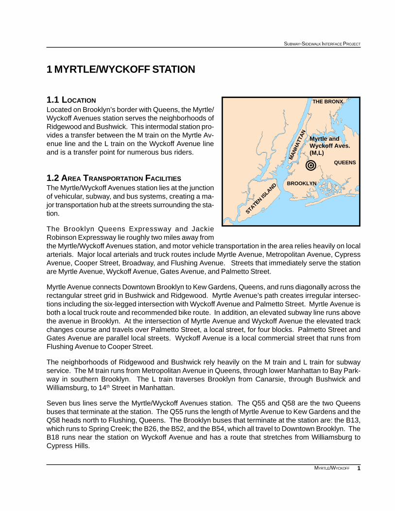
1.1 LOCATIONLocated on Brooklyn’s border with Queens, the Myrtle/Wyckoff Avenues station serves the neighborhoods ofRidgewood and Bushwick. This intermodal station pro-vides a transfer between the M train on the Myrtle Av-enue line and the L train on the Wyckoff Avenue lineand is a transfer point for numerous bus riders.
1.2 AREA TRANSPORTATION FACILITIESThe Myrtle/Wyckoff Avenues station lies at the junctionof vehicular, subway, and bus systems, creating a ma-jor transportation hub at the streets surrounding the sta-tion.
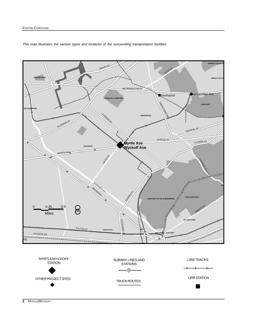
The Brooklyn Queens Expressway and JackieRobinson Expressway lie roughly two miles away fromthe Myrtle/Wyckoff Avenues station, and motor vehicle transportation in the area relies heavily on localarterials. Major local arterials and truck routes include Myrtle Avenue, Metropolitan Avenue, CypressAvenue, Cooper Street, Broadway, and Flushing Avenue. Streets that immediately serve the stationare Myrtle Avenue, Wyckoff Avenue, Gates Avenue, and Palmetto Street.
Myrtle Avenue connects Downtown Brooklyn to Kew Gardens, Queens, and runs diagonally across therectangular street grid in Bushwick and Ridgewood. Myrtle Avenue’s path creates irregular intersec-tions including the six-legged intersection with Wyckoff Avenue and Palmetto Street. Myrtle Avenue isboth a local truck route and recommended bike route. In addition, an elevated subway line runs abovethe avenue in Brooklyn. At the intersection of Myrtle Avenue and Wyckoff Avenue the elevated trackchanges course and travels over Palmetto Street, a local street, for four blocks. Palmetto Street andGates Avenue are parallel local streets. Wyckoff Avenue is a local commercial street that runs fromFlushing Avenue to Cooper Street.
The neighborhoods of Ridgewood and Bushwick rely heavily on the M train and L train for subwayservice. The M train runs from Metropolitan Avenue in Queens, through lower Manhattan to Bay Park-way in southern Brooklyn. The L train traverses Brooklyn from Canarsie, through Bushwick andWilliamsburg, to 14th Street in Manhattan.
Seven bus lines serve the Myrtle/Wyckoff Avenues station. The Q55 and Q58 are the two Queensbuses that terminate at the station. The Q55 runs the length of Myrtle Avenue to Kew Gardens and theQ58 heads north to Flushing, Queens. The Brooklyn buses that terminate at the station are: the B13,which runs to Spring Creek; the B26, the B52, and the B54, which all travel to Downtown Brooklyn. TheB18 runs near the station on Wyckoff Avenue and has a route that stretches from Williamsburg toCypress Hills.
!
Myrtle and Wyckoff Aves.(M,L)
MA
NH
ATT
AN
BROOKLYN
STATEN ISLAND
QUEENS
THE BRONX
2
EXISTING CONDITIONS
MYRTLE/WYCKOFF
This map illustrates the various types and locations of the surrounding transportation facilities
SUBWAY LINES ANDSTATIONS
MYRTLE/WYCKOFFSTATION
LIRR TRACKS
LIRR STATIONTRUCK ROUTES
OTHER PROJECT SITES
""""
""""
""""
""""
""""
"""" """"
""""
""""
""""""""
""""
""""
""""
"""" """" """" """" """"
""""
""""
""""
""""
""""
""""
""""
""""""""
""""
""""
""""
""""""""
#
#
MIDDLE VILLAG
HYLAND PARK
BROADWAY JUNCTION
OCEAN HILL
RIDGEWOOD
BUSHWICK
T WILLIAMSBURG
0 0.25
Miles
0.5
GAT
ES A
V
BUSHWICK AV
BROADWAY
ATLANTIC AV
RO
CK
AW
AY
AV
JAMAIC
A AV
FULTON ST
FLUSHING AV
CO
OPE
R S
T
MYRTLE AV
COOPER AV
CY
PR
ES
S H
ILLS S
T
FRE
SH
PO
ND
RD
METROPOLITAN AV
ELIOT AVGRAND AV
CENTRAL AV
MYRTLE AV
CYPRESS AV
VE
Freshpond Metropolitan Ave
Myrtle AveWyckoff Ave
COOPER PARK
HIGHLAND PARK
JUNIPER VALLEY PA
CEMETERY OF THE EVERGREENS
NAT
CEMETERY
LINDEN HILL CEMETERY
8N
3
SUBWAY-SIDEWALK INTERFACE PROJECT
MYRTLE/WYCKOFF
BLEE
CKE
R S
TGR
EE
NE
AV
MEN
AHAN
ST
GR
OVE S
T
WYCKOFF AV
LIN
DEN
ST
IRVING AV
KNICKERBOCKER AV
WO
ODBIN
E ST
IRVING AV
MYRTLE AV
PALMETT
O S
T
GAT
ES A
V
JEFF
ERSO
N A
VHANCO
CK ST
RIDGEWOOD PL
CO
RN
ELIA
ST
PUTNAM
AV
SENECA AV
ST NICHOLAS AV
CYPRESS AV
MAD
ISO
N S
T
MYRTLE - WYCKOFF
N
ONDERDO
0-21 (37.15%)
65+ (7.93%)
22-64 (54.92%)
AGE DISTRIBUTION: 1990
2. SECONDARY STUDY AREA
The secondary study area includes the quarter mile radius(or an approximate 5 minute walk) surrounding the Myrtle/Wyckoff Avenues station. Roughly, this includes the areabounded by Seneca Avenue, Knickerbocker Avenue,Bleeker Street, and Jefferson Avenue.
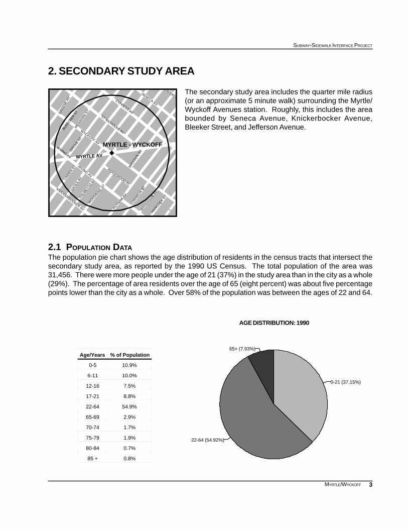
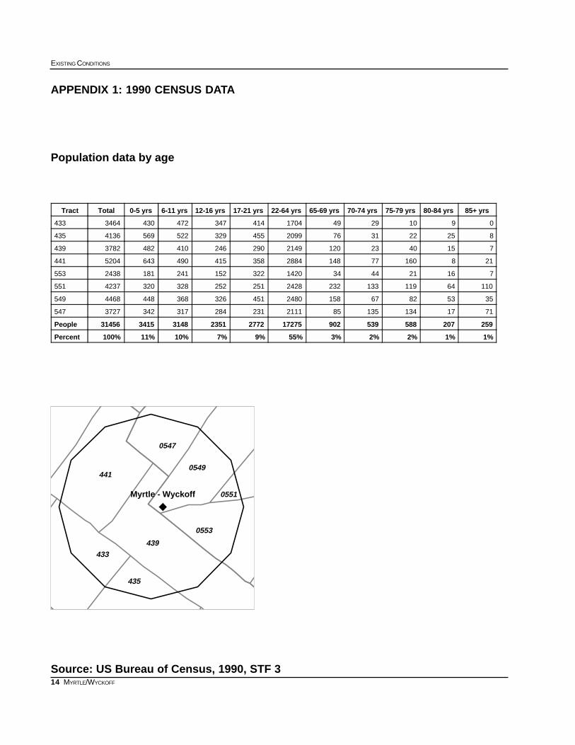
2.1 POPULATION DATAThe population pie chart shows the age distribution of residents in the census tracts that intersect thesecondary study area, as reported by the 1990 US Census. The total population of the area was31,456. There were more people under the age of 21 (37%) in the study area than in the city as a whole(29%). The percentage of area residents over the age of 65 (eight percent) was about five percentagepoints lower than the city as a whole. Over 58% of the population was between the ages of 22 and 64.
% of PopulationAge/Years
10.9%0-5
10.0%6-11
7.5%12-16
8.8%17-21
54.9%22-64
2.9%65-69
1.7%70-74
1.9%75-79
0.7%80-84
0.8%85 +
4
EXISTING CONDITIONS
MYRTLE/WYCKOFF
0 1000 2000 3000 4000 5000 6000 Daily Number of Trips
Taxi
Streetcar, Trolley
Other
Work at Home
Railroad
Carpool
Walk
Bus or Trolley
Car, Truck, or Van
Subway or Elevated
Journey to Work Reverse Journey to Work
JOURNEY TO WORK: 1990 Myrtle-Wyckoff Secondary Study Area
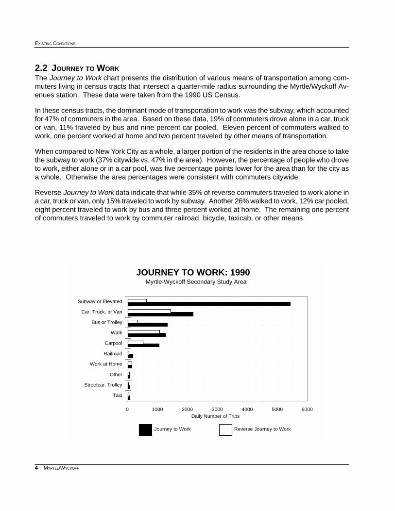
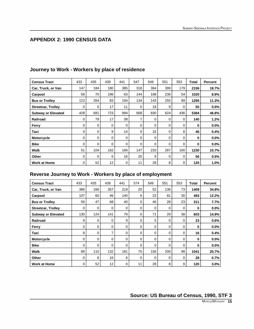
2.2 JOURNEY TO WORKThe Journey to Work chart presents the distribution of various means of transportation among com-muters living in census tracts that intersect a quarter-mile radius surrounding the Myrtle/Wyckoff Av-enues station. These data were taken from the 1990 US Census.
In these census tracts, the dominant mode of transportation to work was the subway, which accountedfor 47% of commuters in the area. Based on these data, 19% of commuters drove alone in a car, truckor van, 11% traveled by bus and nine percent car pooled. Eleven percent of commuters walked towork, one percent worked at home and two percent traveled by other means of transportation.
When compared to New York City as a whole, a larger portion of the residents in the area chose to takethe subway to work (37% citywide vs. 47% in the area). However, the percentage of people who droveto work, either alone or in a car pool, was five percentage points lower for the area than for the city asa whole. Otherwise the area percentages were consistent with commuters citywide.
Reverse Journey to Work data indicate that while 35% of reverse commuters traveled to work alone ina car, truck or van, only 15% traveled to work by subway. Another 26% walked to work, 12% car pooled,eight percent traveled to work by bus and three percent worked at home. The remaining one percentof commuters traveled to work by commuter railroad, bicycle, taxicab, or other means.
5
SUBWAY-SIDEWALK INTERFACE PROJECT
MYRTLE/WYCKOFF
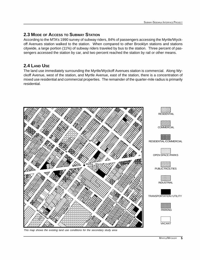
This map shows the existing land use conditions for the secondary study area
RESIDENTIAL /COMMERCIAL
RESIDENTIAL
COMMERCIAL
OPEN SPACE /PARKS
PUBLIC FACILITIES
INDUSTRIAL
PARKING
VACANT
TRANSPORTATION / UTILITY
2.3 MODE OF ACCESS TO SUBWAY STATIONAccording to the MTA’s 1990 survey of subway riders, 84% of passengers accessing the Myrtle/Wyck-off Avenues station walked to the station. When compared to other Brooklyn stations and stationscitywide, a large portion (11%) of subway riders traveled by bus to the station. Three percent of pas-sengers accessed the station by car, and two percent reached the station by rail or other means.
2.4 LAND USEThe land use immediately surrounding the Myrtle/Wyckoff Avenues station is commercial. Along Wy-ckoff Avenue, west of the station, and Myrtle Avenue, east of the station, there is a concentration ofmixed use residential and commercial properties. The remainder of the quarter-mile radius is primarilyresidential.
6
EXISTING CONDITIONS
MYRTLE/WYCKOFF
2.5 ZONING AND DEVELOPMENTThe secondary study area is primarily zoned R6 for medium density residential development. How-ever, a significant portion of the study area to the east is zoned C4-3, which permits shopping centersand offices in densely built areas. Along Myrtle Avenue, west of the study area, there is a C2-3 com-mercial overlay, permitting local retail and service establishments.
2.6 ORGANIZATIONS AND ON-GOING PROJECTSCurrently the Myrtle Avenue Business Improvement District (BID), in Queens Community Board 5, andthe Ridgewood Local Development Corporation are both active in the neighborhood surrounding thestation.
In 1992 the New York City Department of City Planning completed a study of the Ridgewood Wyckoffarea called “Improving Intermodal Transfers.” The New York City Department of Transportation hasconducted their own study called “Intermodal Nodes.”
As it stands now, this station has been selected as an American Disabilities Act (ADA) key station bythe NYC Transit Authority and the award year for funding is currently slated as 2003. A station rehab,currently in the design and planning phase, is also scheduled to be implemented in 2003.
7
SUBWAY-SIDEWALK INTERFACE PROJECT
MYRTLE/WYCKOFF
MYRTLE AVENUE
PALM
ETTO
STR
EET
WYCKOFF AVENUE
GAT
ES A
VENUE
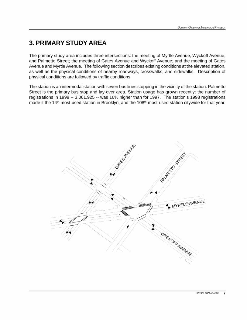
3. PRIMARY STUDY AREA
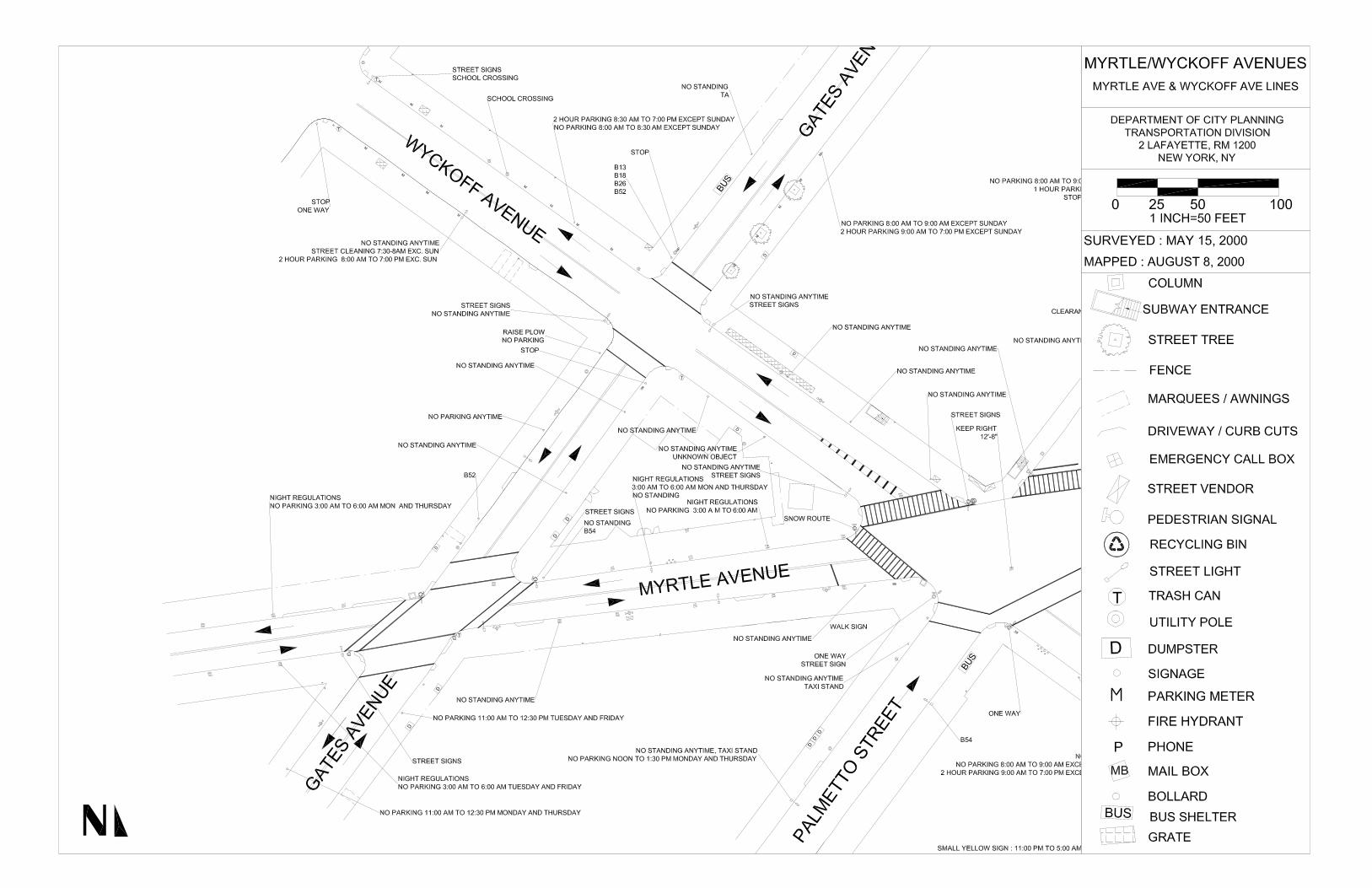
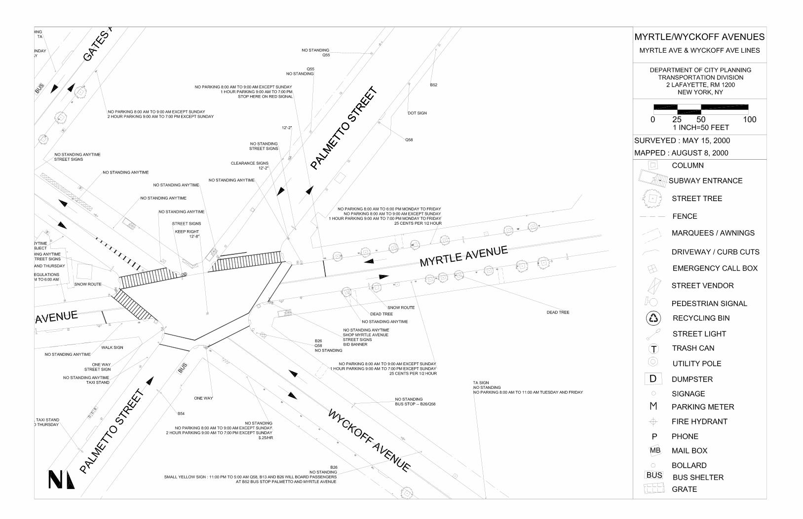
The primary study area includes three intersections: the meeting of Myrtle Avenue, Wyckoff Avenue,and Palmetto Street; the meeting of Gates Avenue and Wyckoff Avenue; and the meeting of GatesAvenue and Myrtle Avenue. The following section describes existing conditions at the elevated station,as well as the physical conditions of nearby roadways, crosswalks, and sidewalks. Description ofphysical conditions are followed by traffic conditions.
The station is an intermodal station with seven bus lines stopping in the vicinity of the station. PalmettoStreet is the primary bus stop and lay-over area. Station usage has grown recently: the number ofregistrations in 1998 -- 3,061,925 -- was 16% higher than for 1997. The station’s 1998 registrationsmade it the 14th-most-used station in Brooklyn, and the 108th-most-used station citywide for that year.

8
EXISTING CONDITIONS
MYRTLE/WYCKOFF
3.1 STATION ENTRANCESThere are five entrances to the Myrtle/WyckoffAvenues station from which all trains may be ac-cessed. Two are located within a New York CityTransit Authority (NYCTA) building on the triangu-lar block bounded by Myrtle, Wyckoff, and GatesAvenues. One of these entrances faces southon Myrtle Avenue and is open 24 hours a day. Theother faces west on Gates Avenue and is openMonday through Saturday from 6:00 AM to 9:00PM.
These entrances are approximately five-and-a-half feet wide. Signage at these entrances is easy tooverlook. Furthermore, the sign above the entrance facing Myrtle Avenue is not illuminated and isdifficult to see, because the elevated structure blocks the natural light. There are no trash receptaclesnear this entrance and refuse has been placed inside the grooves of the support columns for theelevated structure.
The remaining three entrances are standard stairwells and are located on the northern side of WyckoffAvenue, west of Palmetto Street; on the eastern side of Palmetto Street, north of Myrtle Avenue; and onthe southern side of Myrtle Avenue, east of Wyckoff Avenue. The width of these entrances is approxi-mately six feet.
3.2 STREETS ADJACENT TO THE STATION ENTRANCESThe streets adjacent to the Myrtle/Wyckoff Avenues station consist of three intersections, two of whichhave irregular street geometry. The third intersection forms a 90 degree angle.
3.2.1 RoadwaysMyrtle Avenue is a two way arterial that runseast-west from Downtown Brooklyn to Kew Gar-dens in Queens. The roadbed is approximately35 feet wide in the study area, with one travel laneand one parking lane in each direction; the road-way is divided in the center by a double yellowline. The elevated structure runs above MyrtleAvenue west of its intersection with Wyckoff Av-enue and Palmetto Street. At the intersection ofMyrtle Avenue, Wyckoff Avenue, and PalmettoStreet, the elevated tracks turn northeast andtravel above Palmetto Street.
Along Myrtle Avenue one hour metered parking is permitted east of Palmetto Street. Parking is notpermitted during hours of street cleaning.
Myrtle Avenue is listed as a recommended bicycle route.
Myrtle Avenue, west of Palmetto Street
Entrance facing Gates Avenue
9
SUBWAY-SIDEWALK INTERFACE PROJECT
MYRTLE/WYCKOFF
Gates Avenue, north of Myrtle Avenue
Palmetto Street, south of Myrtle Avenue
Wyckoff Avenue is a two way local street that runs east-west from Flushing Avenue to Cooper Avenuealong the border between Brooklyn and Queens. The roadbed is approximately 40 feet wide with onetravel lane and one parking lane in each direction. It is divided by a double yellow line. Two hourmetered parking is permitted on both sides of the street.
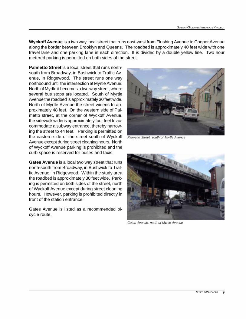
Palmetto Street is a local street that runs north-south from Broadway, in Bushwick to Traffic Av-enue, in Ridgewood. The street runs one waynorthbound until the intersection at Myrtle Avenue.North of Myrtle it becomes a two way street, whereseveral bus stops are located. South of MyrtleAvenue the roadbed is approximately 30 feet wide.North of Myrtle Avenue the street widens to ap-proximately 48 feet. On the western side of Pal-metto street, at the corner of Wyckoff Avenue,the sidewalk widens approximately four feet to ac-commodate a subway entrance, thereby narrow-ing the street to 44 feet. Parking is permitted onthe eastern side of the street south of WyckoffAvenue except during street cleaning hours. Northof Wyckoff Avenue parking is prohibited and thecurb space is reserved for buses and taxis.
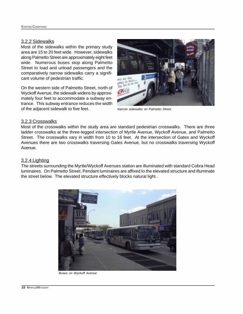
Gates Avenue is a local two way street that runsnorth-south from Broadway, in Bushwick to Traf-fic Avenue, in Ridgewood. Within the study areathe roadbed is approximately 30 feet wide. Park-ing is permitted on both sides of the street, northof Wyckoff Avenue except during street cleaninghours. However, parking is prohibited directly infront of the station entrance.
Gates Avenue is listed as a recommended bi-cycle route.
10
EXISTING CONDITIONS
MYRTLE/WYCKOFF
Narrow sidewalks on Palmetto Street
Buses on Wyckoff Avenue
3.2.2 SidewalksMost of the sidewalks within the primary studyarea are 15 to 20 feet wide. However, sidewalksalong Palmetto Street are approximately eight feetwide. Numerous buses stop along PalmettoStreet to load and unload passengers and thecomparatively narrow sidewalks carry a signifi-cant volume of pedestrian traffic.
On the western side of Palmetto Street, north ofWyckoff Avenue, the sidewalk widens by approxi-mately four feet to accommodate a subway en-trance. This subway entrance reduces the widthof the adjacent sidewalk to five feet.
3.2.3 CrosswalksMost of the crosswalks within the study area are standard pedestrian crosswalks. There are threeladder crosswalks at the three-legged intersection of Myrtle Avenue, Wyckoff Avenue, and PalmettoStreet. The crosswalks vary in width from 10 to 16 feet. At the intersection of Gates and WyckoffAvenues there are two crosswalks traversing Gates Avenue, but no crosswalks traversing WyckoffAvenue.
3.2.4 LightingThe streets surrounding the Myrtle/Wyckoff Avenues station are illuminated with standard Cobra Headluminaires. On Palmetto Street, Pendant luminaires are affixed to the elevated structure and illuminatethe street below. The elevated structure effectively blocks natural light .
11
SUBWAY-SIDEWALK INTERFACE PROJECT
MYRTLE/WYCKOFF
MTA dispatch booth
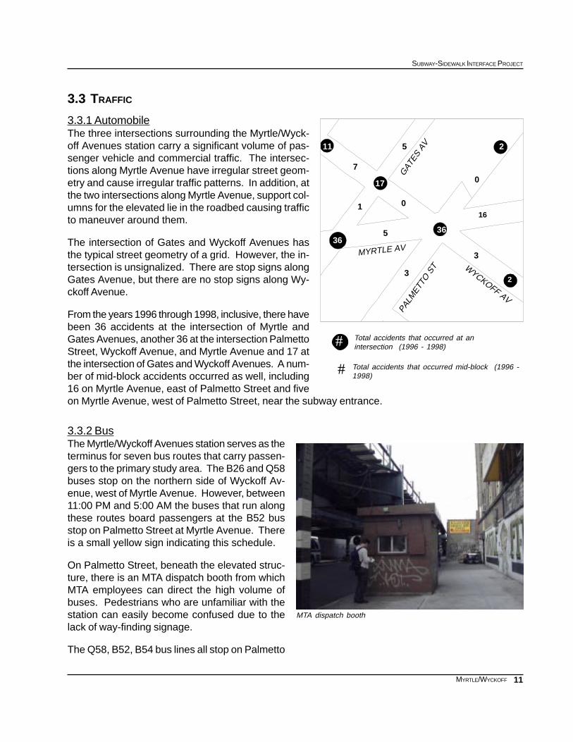
3.3 TRAFFIC
3.3.1 AutomobileThe three intersections surrounding the Myrtle/Wyck-off Avenues station carry a significant volume of pas-senger vehicle and commercial traffic. The intersec-tions along Myrtle Avenue have irregular street geom-etry and cause irregular traffic patterns. In addition, atthe two intersections along Myrtle Avenue, support col-umns for the elevated lie in the roadbed causing trafficto maneuver around them.
The intersection of Gates and Wyckoff Avenues hasthe typical street geometry of a grid. However, the in-tersection is unsignalized. There are stop signs alongGates Avenue, but there are no stop signs along Wy-ckoff Avenue.
From the years 1996 through 1998, inclusive, there havebeen 36 accidents at the intersection of Myrtle andGates Avenues, another 36 at the intersection PalmettoStreet, Wyckoff Avenue, and Myrtle Avenue and 17 atthe intersection of Gates and Wyckoff Avenues. A num-ber of mid-block accidents occurred as well, including16 on Myrtle Avenue, east of Palmetto Street and fiveon Myrtle Avenue, west of Palmetto Street, near the subway entrance.
3.3.2 BusThe Myrtle/Wyckoff Avenues station serves as theterminus for seven bus routes that carry passen-gers to the primary study area. The B26 and Q58buses stop on the northern side of Wyckoff Av-enue, west of Myrtle Avenue. However, between11:00 PM and 5:00 AM the buses that run alongthese routes board passengers at the B52 busstop on Palmetto Street at Myrtle Avenue. Thereis a small yellow sign indicating this schedule.
On Palmetto Street, beneath the elevated struc-ture, there is an MTA dispatch booth from whichMTA employees can direct the high volume ofbuses. Pedestrians who are unfamiliar with thestation can easily become confused due to thelack of way-finding signage.
The Q58, B52, B54 bus lines all stop on Palmetto
Total accidents that occurred at anintersection (1996 - 1998)
Total accidents that occurred mid-block (1996 -1998)
#
#
2
0
3
316
36
2
0
5
3
5
17
1
7
11
36
WYCKOFF AV
MYRTLE AV
PALM
ETTO
ST
GAT
ES A
V
12
EXISTING CONDITIONS
MYRTLE/WYCKOFF
Pedestrians obey signal and cross unmarkedpavement
Street beneath the elevated structure. The B13, B18, B26,and B52 buses all stop on the western side of Gates Av-enue, north of Wyckoff Avenue. The Q55 stops on Pal-metto Street, south of Myrtle Avenue.
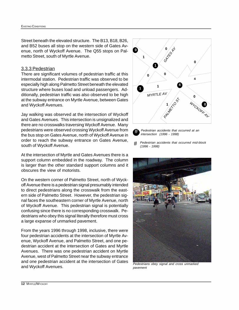
3.3.3 PedestrianThere are significant volumes of pedestrian traffic at thisintermodal station. Pedestrian traffic was observed to beespecially high along Palmetto Street beneath the elevatedstructure where buses load and unload passengers. Ad-ditionally, pedestrian traffic was also observed to be highat the subway entrance on Myrtle Avenue, between Gatesand Wyckoff Avenues.
Jay walking was observed at the intersection of Wyckoffand Gates Avenues. This intersection is unsignalized andthere are no crosswalks traversing Wyckoff Avenue. Manypedestrians were observed crossing Wyckoff Avenue fromthe bus stop on Gates Avenue, north of Wyckoff Avenue inorder to reach the subway entrance on Gates Avenue,south of Wyckoff Avenue.
At the intersection of Myrtle and Gates Avenues there is asupport column embedded in the roadway. The columnis larger than the other standard support columns and itobscures the view of motorists.
On the western corner of Palmetto Street, north of Wyck-off Avenue there is a pedestrian signal presumably intendedto direct pedestrians along the crosswalk from the east-ern side of Palmetto Street. However, the pedestrian sig-nal faces the southeastern corner of Myrtle Avenue, northof Wyckoff Avenue. This pedestrian signal is potentiallyconfusing since there is no corresponding crosswalk. Pe-destrians who obey this signal literally therefore must crossa large expanse of unmarked pavement.
From the years 1996 through 1998, inclusive, there werefour pedestrian accidents at the intersection of Myrtle Av-enue, Wyckoff Avenue, and Palmetto Street, and one pe-destrian accident at the intersection of Gates and MyrtleAvenues. There was one pedestrian accident on MyrtleAvenue, west of Palmetto Street near the subway entranceand one pedestrian accident at the intersection of Gatesand Wyckoff Avenues.
Pedestrian accidents that occurred at anintersection (1996 - 1998)
#
Pedestrian accidents that occurred mid-block(1996 - 1998)
#
3
0
0
1
00
1
00
1
0
4
41
1
MYRTLE AV
PALM
ETTO
ST
WYCKOFF AV
GAT
ES A
V
13
SUBWAY-SIDEWALK INTERFACE PROJECT
MYRTLE/WYCKOFF
MYRTLE/WYCKOFF APPENDICES
APPENDIX 1: 1990 CENSUS DATA
Population Data by Age and Census Tract
APPENDIX 2: 1990 CENSUS DATA
Journey to Work - Workers by place of residence
Reverse Journey to Work - Workers by place of employment
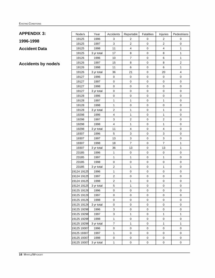
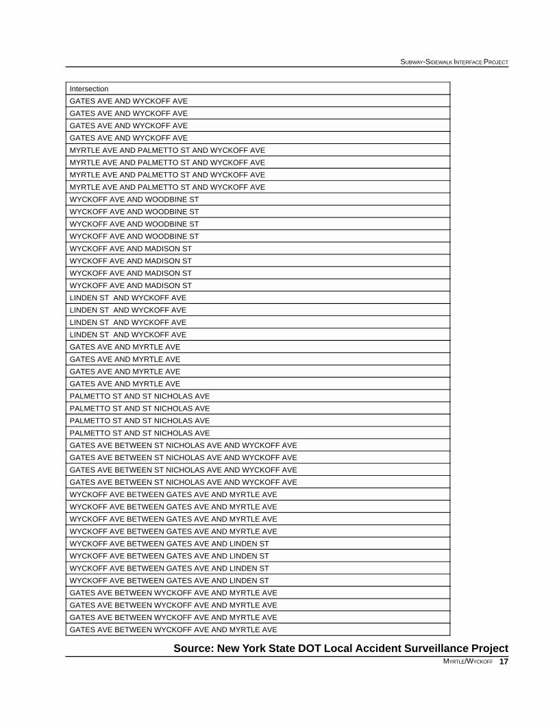
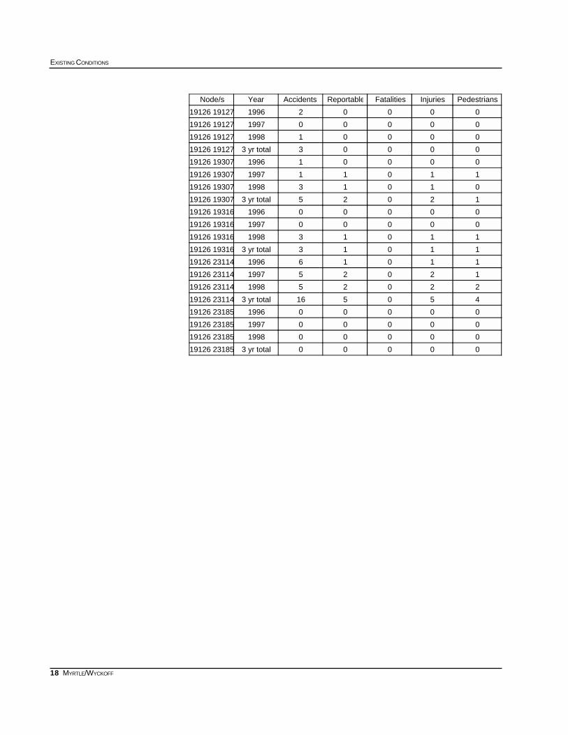
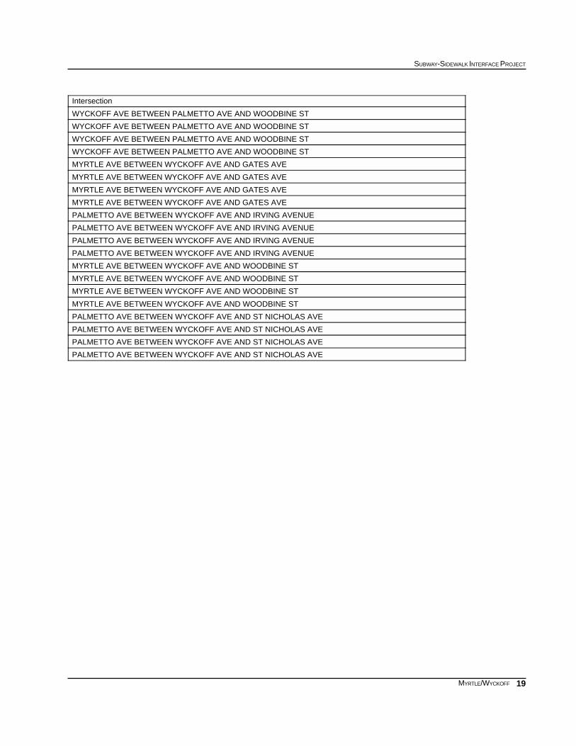
APPENDIX 3: 1996-1998 ACCIDENT DATA
Accidents by Node/s
APPENDIX 4: SIGNAL TIMING DATA
APPENDIX 5: INVENTORY OF EXISTING CONDITIONS
14
EXISTING CONDITIONS
MYRTLE/WYCKOFF
Population data by age
APPENDIX 1: 1990 CENSUS DATA
Source: US Bureau of Census, 1990, STF 3
439
435
433
441
0551
0549
0553
0547
Myrtle - Wyckoff
85+ yrs80-84 yrs75-79 yrs70-74 yrs65-69 yrs22-64 yrs17-21 yrs12-16 yrs6-11 yrs0-5 yrsTotalTract
0910294917044143474724303464433
82522317620994553295225694136435
715402312021492902464104823782439
2181607714828843584154906435204441
71621443414203221522411812438553
1106411913323224282512523283204237551
3553826715824804513263684484468549
71171341358521112312843173423727547
25920758853990217275277223513148341531456People
1%1%2%2%3%55%9%7%10%11%100%Percent
15
SUBWAY-SIDEWALK INTERFACE PROJECT
MYRTLE/WYCKOFF
APPENDIX 2: 1990 CENSUS DATA
Journey to Work - Workers by place of residence
Reverse Journey to Work - Workers by place of employment
Source: US Bureau of Census, 1990, STF 3
PercentTotal553551549547441439435433Census Tract
18.7%2156179399364318385180184147Car, Truck, or Van
8.9%102054236198144631967059Carpool
11.3%12959925514313419483264123Bus or Trolley
0.5%5509180111700Streetcar, Trolley
46.8%5384436624830668994723681428Subway or Elevated
1.2%14000073817780Railroad
0.0%000000000Ferry
0.4%468015014900Taxi
0.0%000000000Motorcycle
0.0%000000000Bike
10.7%123010026723314716616210451Walk
0.5%560092516600Other
1.0%120982811012520Work at Home
PercentTotal553551549574441439435433Census Tract
34.8%1409731365220219357166386Car, Truck, or Van
12.2%49330812361404660107Carpool
7.7%311232846040684759Bus or Trolley
0.0%000000000Streetcar, Trolley
14.9%603382071079141124130Subway or Elevated
0.6%2300509009Railroad
0.0%000000000Ferry
0.4%1600000709Taxi
0.0%000000000Motorcycle
0.0%000000000Bike
25.7%1041982001567518113211089Walk
0.7%28000061660Other
3.0%120982811012520Work at Home
16
EXISTING CONDITIONS
MYRTLE/WYCKOFF
APPENDIX 3:
1996-1998
Accident Data
Accidents by node/s
PedestriansInjuriesFatalitiesReportableAccidentsYearNode/s
02023199619125
02023199719125
140411199819125
1808173 yr total19125
160710199619126
280815199719126
160611199819126
420021363 yr total19126
00000199619127
00000199719127
00000199819127
000003 yr total19127
00000199619128
01011199719128
00001199819128
010123 yr total19128
01014199619298
02023199719298
01014199819298
0404113 yr total19298
03035199619307
030313199719307
170718199819307
113013363 yr total19307
00001199623185
01011199723185
00000199823185
010123 yr total23185
00001199619124 19125
00002199719124 19125
00012199819124 19125
000153 yr total19124 19125
00000199619125 19126
00000199719125 19126
00000199819125 19126
000003 yr total19125 19126
00003199619125 19298
11013199719125 19298
00001199819125 19298
110173 yr total19125 19298
00000199619125 19307
00001199719125 19307
00000199819125 19307
000013 yr total19125 19307
17
SUBWAY-SIDEWALK INTERFACE PROJECT
MYRTLE/WYCKOFF
Source: New York State DOT Local Accident Surveillance Project
Intersection
GATES AVE AND WYCKOFF AVE
GATES AVE AND WYCKOFF AVE
GATES AVE AND WYCKOFF AVE
GATES AVE AND WYCKOFF AVE
MYRTLE AVE AND PALMETTO ST AND WYCKOFF AVE
MYRTLE AVE AND PALMETTO ST AND WYCKOFF AVE
MYRTLE AVE AND PALMETTO ST AND WYCKOFF AVE
MYRTLE AVE AND PALMETTO ST AND WYCKOFF AVE
WYCKOFF AVE AND WOODBINE ST
WYCKOFF AVE AND WOODBINE ST
WYCKOFF AVE AND WOODBINE ST
WYCKOFF AVE AND WOODBINE ST
WYCKOFF AVE AND MADISON ST
WYCKOFF AVE AND MADISON ST
WYCKOFF AVE AND MADISON ST
WYCKOFF AVE AND MADISON ST
LINDEN ST AND WYCKOFF AVE
LINDEN ST AND WYCKOFF AVE
LINDEN ST AND WYCKOFF AVE
LINDEN ST AND WYCKOFF AVE
GATES AVE AND MYRTLE AVE
GATES AVE AND MYRTLE AVE
GATES AVE AND MYRTLE AVE
GATES AVE AND MYRTLE AVE
PALMETTO ST AND ST NICHOLAS AVE
PALMETTO ST AND ST NICHOLAS AVE
PALMETTO ST AND ST NICHOLAS AVE
PALMETTO ST AND ST NICHOLAS AVE
GATES AVE BETWEEN ST NICHOLAS AVE AND WYCKOFF AVE
GATES AVE BETWEEN ST NICHOLAS AVE AND WYCKOFF AVE
GATES AVE BETWEEN ST NICHOLAS AVE AND WYCKOFF AVE
GATES AVE BETWEEN ST NICHOLAS AVE AND WYCKOFF AVE
WYCKOFF AVE BETWEEN GATES AVE AND MYRTLE AVE
WYCKOFF AVE BETWEEN GATES AVE AND MYRTLE AVE
WYCKOFF AVE BETWEEN GATES AVE AND MYRTLE AVE
WYCKOFF AVE BETWEEN GATES AVE AND MYRTLE AVE
WYCKOFF AVE BETWEEN GATES AVE AND LINDEN ST
WYCKOFF AVE BETWEEN GATES AVE AND LINDEN ST
WYCKOFF AVE BETWEEN GATES AVE AND LINDEN ST
WYCKOFF AVE BETWEEN GATES AVE AND LINDEN ST
GATES AVE BETWEEN WYCKOFF AVE AND MYRTLE AVE
GATES AVE BETWEEN WYCKOFF AVE AND MYRTLE AVE
GATES AVE BETWEEN WYCKOFF AVE AND MYRTLE AVE
GATES AVE BETWEEN WYCKOFF AVE AND MYRTLE AVE
18
EXISTING CONDITIONS
MYRTLE/WYCKOFF
PedestriansInjuriesFatalitiesReportableAccidentsYearNode/s
00002199619126 19127
00000199719126 19127
00001199819126 19127
000033 yr total19126 19127
00001199619126 19307
11011199719126 19307
01013199819126 19307
120253 yr total19126 19307
00000199619126 19316
00000199719126 19316
11013199819126 19316
110133 yr total19126 19316
11016199619126 23114
12025199719126 23114
22025199819126 23114
4505163 yr total19126 23114
00000199619126 23185
00000199719126 23185
00000199819126 23185
000003 yr total19126 23185
19
SUBWAY-SIDEWALK INTERFACE PROJECT
MYRTLE/WYCKOFF
Intersection
WYCKOFF AVE BETWEEN PALMETTO AVE AND WOODBINE ST
WYCKOFF AVE BETWEEN PALMETTO AVE AND WOODBINE ST
WYCKOFF AVE BETWEEN PALMETTO AVE AND WOODBINE ST
WYCKOFF AVE BETWEEN PALMETTO AVE AND WOODBINE ST
MYRTLE AVE BETWEEN WYCKOFF AVE AND GATES AVE
MYRTLE AVE BETWEEN WYCKOFF AVE AND GATES AVE
MYRTLE AVE BETWEEN WYCKOFF AVE AND GATES AVE
MYRTLE AVE BETWEEN WYCKOFF AVE AND GATES AVE
PALMETTO AVE BETWEEN WYCKOFF AVE AND IRVING AVENUE
PALMETTO AVE BETWEEN WYCKOFF AVE AND IRVING AVENUE
PALMETTO AVE BETWEEN WYCKOFF AVE AND IRVING AVENUE
PALMETTO AVE BETWEEN WYCKOFF AVE AND IRVING AVENUE
MYRTLE AVE BETWEEN WYCKOFF AVE AND WOODBINE ST
MYRTLE AVE BETWEEN WYCKOFF AVE AND WOODBINE ST
MYRTLE AVE BETWEEN WYCKOFF AVE AND WOODBINE ST
MYRTLE AVE BETWEEN WYCKOFF AVE AND WOODBINE ST
PALMETTO AVE BETWEEN WYCKOFF AVE AND ST NICHOLAS AVE
PALMETTO AVE BETWEEN WYCKOFF AVE AND ST NICHOLAS AVE
PALMETTO AVE BETWEEN WYCKOFF AVE AND ST NICHOLAS AVE
PALMETTO AVE BETWEEN WYCKOFF AVE AND ST NICHOLAS AVE
20
EXISTING CONDITIONS
MYRTLE/WYCKOFF
FE
G
H
I
J
A
C D
B
GAT
ES A
V
WYCKOFF AV
MYRTLE AV
PALM
ETTO
ST
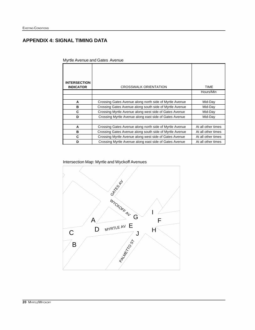
APPENDIX 4: SIGNAL TIMING DATA
Myrtle Avenue and Gates Avenue
Intersection Map: Myrtle and Wyckoff Avenues
TIMECROSSWALK ORIENTATIONINDICATORINTERSECTION
Hours/Min
Mid-DayCrossing Gates Avenue along north side of Myrtle AvenueAMid-DayCrossing Gates Avenue along south side of Myrtle AvenueBMid-DayCrossing Myrtle Avenue along west side of Gates AvenueCMid-DayCrossing Myrtle Avenue along east side of Gates AvenueD
At all other timesCrossing Gates Avenue along north side of Myrtle AvenueAAt all other timesCrossing Gates Avenue along south side of Myrtle AvenueBAt all other timesCrossing Myrtle Avenue along west side of Gates AvenueCAt all other timesCrossing Myrtle Avenue along east side of Gates AvenueD
21
SUBWAY-SIDEWALK INTERFACE PROJECT
MYRTLE/WYCKOFF
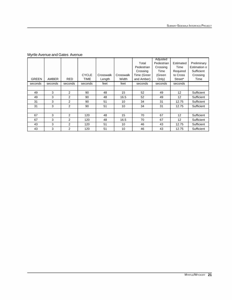
Myrtle Avenue and Gates Avenue
TimeCrossingSufficient
Estimation ofPreliminary
Street*to CrossRequired
TimeEstimated
Only)(GreenTime
CrossingPedestrianAdjusted
and Amber)Time (Green
CrossingPedestrian
Total
WidthCrosswalk
LengthCrosswalk
TIMECYCLE
REDAMBERGREEN
secondssecondssecondsfeetfeetsecondssecondssecondsseconds
Sufficient1249521548902349
Sufficient12495216.548902349
Sufficient12.7531341051902331
Sufficient12.7531341051902331
Sufficient12677015481202367
Sufficient12677016.5481202367
Sufficient12.75434610511202343
Sufficient12.75434610511202343
22
EXISTING CONDITIONS
MYRTLE/WYCKOFF
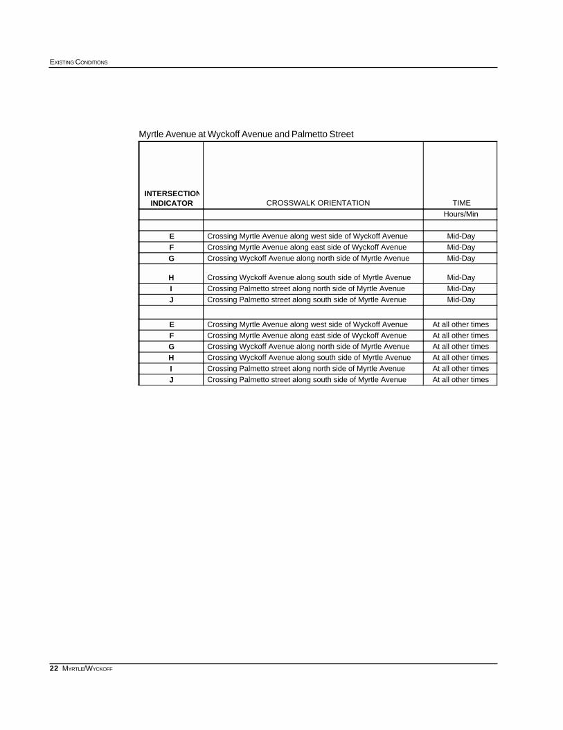
Myrtle Avenue at Wyckoff Avenue and Palmetto Street
TIMECROSSWALK ORIENTATIONINDICATORINTERSECTION
Hours/Min
Mid-DayCrossing Myrtle Avenue along west side of Wyckoff AvenueEMid-DayCrossing Myrtle Avenue along east side of Wyckoff AvenueFMid-DayCrossing Wyckoff Avenue along north side of Myrtle AvenueG
Mid-DayCrossing Wyckoff Avenue along south side of Myrtle AvenueHMid-DayCrossing Palmetto street along north side of Myrtle AvenueIMid-DayCrossing Palmetto street along south side of Myrtle AvenueJ
At all other timesCrossing Myrtle Avenue along west side of Wyckoff AvenueEAt all other timesCrossing Myrtle Avenue along east side of Wyckoff AvenueFAt all other timesCrossing Wyckoff Avenue along north side of Myrtle AvenueGAt all other timesCrossing Wyckoff Avenue along south side of Myrtle AvenueHAt all other timesCrossing Palmetto street along north side of Myrtle AvenueIAt all other timesCrossing Palmetto street along south side of Myrtle AvenueJ
23
SUBWAY-SIDEWALK INTERFACE PROJECT
MYRTLE/WYCKOFF
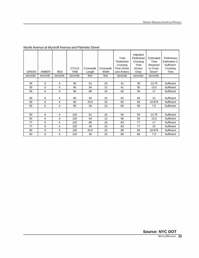
Myrtle Avenue at Wyckoff Avenue and Palmetto Street
Source: NYC DOT
TimeCrossingSufficient
Estimation ofPreliminary
Street*to CrossRequired
TimeEstimated
Only)(GreenTime
CrossingPedestrianAdjusted
and Amber)Time (Green
CrossingPedestrian
Total
WidthCrosswalk
LengthCrosswalk
TIMECYCLE
REDAMBERGREEN
secondssecondssecondsfeetfeetsecondssecondssecondsseconds
Sufficient12.7535411651904635
Sufficient13.535411254904635
Sufficient1756621968904656
Sufficient1056621040904656
Sufficient10.87559651543.5904659
Sufficient7.559651530904659
Sufficient12.75505616511204650
Sufficient13.5505612541204650Sufficient17778319681204677
Sufficient10778310401204677
Sufficient10.87583891543.51204683
Sufficient7.5838915301204683