Embed Size (px)
Citation preview
Whitmarsh, R.B., Beslier, M.-O., Wallace, P.J., et al., 1998Proceedings of the Ocean Drilling Program, Initial Reports, Vol. 173
1. LEG 173 INTRODUCTION1
Shipboard Scientific Party2
ta
ig eBaor
ta) arenune matca pav87tsn
aehruliecatC
upf tm
dar-rift-smnict of con-
theicalthinent
-ofin.-
rea-aultsnd up-mase-umi- arehit-on, thed,gon-gin.owentally49,p
d toar-
late, orst.ent
on-n oft, orndvo-stillyn-ift/orsmicp tocha-
in-he
BACKGROUND
The rifting and breakup of continental lithosphere to form passiveor rifted continental margins is one of the most fundamental geolog-ical processes on earth. It has many physical similarities with the for-mation of intraplate sedimentary basins and relates directly to the on-set of seafloor spreading, a process that generates the mid-ocean ridg-es and the crust underlying the ocean basins. Rifted margins exhibita wide spectrum of characteristics, apparently greater than is seen incontinental rifts, probably in response to the large magnitude of ex-tension and different combinations of asthenospheric temperature,lithospheric rheology, strain rate, and stress. The rifting process,through the indirect effects of concurrent greater sedimentation andheat flow and sub-aerial volcanism can also have important environ-mental and resource implications. Because of the thick to very thick(2 to 15 km) sediments found on many rifted margins and the conse-quent inaccessibility of basement rocks to scientific drilling, howev-er, rifted margins had, until 1993, largely been studied by remote geo-physical means or by the post- and synrift history recorded in theoverlying sediments at a few “sediment-starved” margins. InNortheast Atlantic before 1993, for example, nonvolcanic rifted mgins were drilled off Northern Biscay (Montadert et al., 1979b), VSeamount (Sibuet et al., 1979), the Mazagan Escarpment (Hinz1984), Goban Spur (de Graciansky et al., 1985), and Galicia (Boillot, Winterer, et al., 1988) where crystalline basement was cfor the first time on the west Iberia margin.
Quantitative models have been developed for the postrift isosand thermal subsidence of margins and basins (McKenzie, 1978more recently, for the critical effect of asthenospheric temperatuthe time of lithospheric breakup on the quantity and compositiomelt that may be underplated at the base of the crust and/or eras lavas at the surface (Bown and White, 1995; White and McKe1989). Finite element models have also been developed to modtectonic evolution of the crust and lithosphere under extensionalgins (e.g., Bassi, 1991, 1995; Harry and Sawyer, 1992). Qualitconceptual models also have been proposed based on geologivestigations in extensional terrains such as the Basin and Rangeince (Wernicke, 1985; Wernicke and Burchfiel, 1982), which hbeen extrapolated to rifted continental margins (Boillot et al., 191988b; Le Pichon and Barbier, 1987; Lister et al., 1986; Reston e1995), or on fossil passive margins trapped in orogens, such aLigurian Tethys margins in the Alps (e.g., Froitzheim aManatschal, 1996; Lemoine et al., 1987). Further, small-scalelogical models have been employed to explore the mechanical bior of the lithosphere during extension (e.g., Allemand and B1991; Beslier and Brun, 1991; Brun et al., 1994; Brun and Bes1996). Nevertheless, in spite of the predictive capability of all thmodels, some uncertainty remains both about the geological proes involved in the crust and mantle and in particular about the nand location of features such as the ocean/continent transition (O
The North Atlantic Rifted Margins Detailed Planning Gro(NARM DPG) was convened by the then Planning Committee oOcean Drilling Program (ODP) and met in 1991 to plan a progra
1Whitmarsh, R.B., Beslier, M.-O., Wallace, P.J., et al., 1998. Proc. ODP, Init.Repts., 173: College Station, TX (Ocean Drilling Program).
2Shipboard Scientific Party is given in the list preceding the Table of Contents.
her-ot al.,nked
ticnd, at
ofptedzie,l thear-ivel in-rov-ea,
al., thedna-av-n,er,seess-ureT).
he of
drilling to study the problems of the formation and evolution of riftemargins. The Group identified two important classes of rifted mgins to be studied: margins in which magmatism dominated the ing process (volcanic margins) and margins in which magmatiseems to have played a minor role in the rifting process (nonvolcamargins). The DPG recommended that ODP focus on a transecholes across each class of margin and that each transect include ajugate pair of margins. The criteria for selecting the locations of two transects included (1) the existence of high-quality geophysdata on both conjugate margins, (2) the presence of a relatively sediment cover on the conjugate margins so that drilling to basemis possible using the JOIDES Resolution, (3) the absence of salt deposits, which could interfere with drilling, and (4) the absence postrift volcanism, which could have modified the divergent marg
Non-volcanic margins in particular provide opportunities to investigate and understand the tectonic aspects of rifting for two sons. First, extensional tectonics, often expressed as normal fand shear zones, that are seen to penetrate deep into the crust apermost mantle on seismic reflection profiles, allows rocks frodeeper lithospheric levels to be exposed at the top of acoustic bment, as was demonstrated by Legs 103 and 149. Second, volnous intrusives/extrusives, which can obscure crustal tectonics,limited and commonly appear to be absent. Leg 149 (Sawyer, Wmarsh, Klaus, et al., 1994; Whitmarsh, Sawyer, Klaus, Mass1996) and Leg 173 represented part of the program proposed byDPG for the study of nonvolcanic margins. As originally envisagethe total program, requiring four two-month legs, included drillinmultiple sites in both the southern Iberia Abyssal Plain and the cjugate Newfoundland Basin, and one site on the Galicia Bank marDrilling on each of the margins was to include sites that would allsampling of significant sections of basement with minimum sedimpenetration and sites that would sample thicker and stratigraphicmore complete sequences of synrift and postrift sediment. Leg 1followed by Leg 173, drilled sites of the first type off Iberia; a deehole in the Iberia Abyssal Plain sediments has yet to be plannecomplement the Leg 149 and Leg 173 results. Conjugate rifted mgins often exhibit some asymmetry in structural style that may reto the mode of lithospheric rifting (e.g., pure and/or simple shear)simply to the location of the original break in the continental cruAlthough the original program was also designed to allow assessmof the degree of symmetry in the structure and evolution of the cjugate margin, this has not been possible so far. Characterizatiobasement type (thinned continental crust, transitional basemenoceanic crust) within a wide zone of the Newfoundland Basin aIberia Abyssal Plain, the location of the OCT, and the nature and elution of the corresponding basement rocks on the two margins remain important scientific objectives. Sites designed to sample srift sequences will constrain the timing of rifting and breakup, the renvironment, and possibly significant anomalous elevation andsubsidence asymmetries that are strongly indicated by some seidata. The subsidence histories of the conjugate margins will heldetermine the relative importance of pure and simple shear menisms of extension on a lithospheric scale.
THE WEST IBERIA CONTINENTAL MARGIN
The western continental margin of Iberia extends from Cape Fisterre in the north to Cape Saint Vincent in the south (Fig. 1). T
7
SHIPBOARD SCIENTIFIC PARTY
cath
pouwdur
or Taic
lonnd96ew
engso Bpa90 J hare
steho
in erho88t auabl.ismanrtinit 1
anm o thhefle 1
edl e).asrmucbeupThunan
Ma in9)
w nd
99 an
oef, ofbe-eria
valefule Jronheustha-l-va92) 2); the
hree wests- theagus tontleentnsetCTigu-g-
hec re-ndfret ett al.,illotuf-5a;).m-
ac-
ed inichthst
eld,he
heed
the theereted.,er-g,the
continental margin has a straight, relatively narrow shelf and a steepcontinental slope. South of 40°N, the slope is cut by numerousyons. This simple picture is complicated by several offshore bametric features. The largest feature is Galicia Bank, a 200 × 150-kmarea within which the seafloor shoals to about 600 m water deGalicia Bank is characterized by two isolated seamounts on its sern edge (Vasco da Gama and Vigo) and is separated from northern Iberia by a broad submarine valley. At 39°N, the EstremaSpur extends east-west over 100 km offshore and forms a barrietween the Iberia and Tagus Abyssal Plains. Finally, the east-neast−trending Gorringe Bank forms the southern boundary of thegus Abyssal Plain and marks the surface expression of the seismactive Eurasia/Africa plate boundary.
Like many rifted or passive margins, the Iberia margin had a history of rifting before the separation of Iberia from the GraBanks of North America (see the review by Pinheiro et al., 19Welsink et al. (1989) describe the rift history of the conjugate Nfoundland margin.
Broadly, three main Mesozoic rifting episodes affected the wIberia margin although all three episodes cannot be convincidemonstrated together in any one part of the margin. These epiare variously recorded in the deposits of the onshore Lusitaniansin, which is probably continuous with the Interior Basin that serates Galicia Bank from northwestern Iberia (Murillas et al., 19Wilson et al., 1989), and offshore. Evidence for a Triassic to Earlyrassic (Liassic) continental rifting phase that created graben andgraben structures in which evaporites were deposited is widespon North Atlantic margins. The second rifting phase, which consiof extension in the early Late Jurassic, is indicated solely on onsand shelf seismic profiles. The last phase of extension occurred Early Cretaceous, coincided with the south-to-north breakup of Ibfrom the Grand Banks and has been well documented with offsgeological and geophysical data (Boillot, Winterer, et al., 191989; Pinheiro et al., 1992; Whitmarsh et al., 1990; Wilson e1996). The precise dating and duration of this last episode is arg(Wilson et al., 1996); in fact, different parts of the margin probarifted at different times as rifting propagated from south to north
The rifting phases were accompanied by only minor volcan(dikes and flows) within Iberia. Two phases of pre-breakup volcism have been recognized by Ribeiro et al. (1979) and Ma(1991). A tholeiitic phase lasted from 190 to 160 Ma, coeval wLate Jurassic rifting, and a second phase occurred from 135 toMa in the Lusitanian Basin. This volcanism was relatively minor, the west Iberia margin has the characteristics of a nonvolcanic gin. For example, tilted fault blocks and half-grabens are clearlyserved off Galicia Bank (Mauffret and Montadert, 1987), and insouthern part of the Lusitanian Basin (Wilson et al., 1989), and tis no evidence on any part of the margin of seaward-dipping retors or of substantial subcrustal underplating. Nevertheless, Legpenetrated 56 m of gabbro that underwent deformation that end136.4 Ma at Site 900; the gabbro probably represents materiaplaced at the base of the crust during rifting (Féraud et al., 1996
Parts of the west Iberia margin underwent two additional phof deformation in the Eocene and the Miocene. The Eocene defotion was caused by the Pyrenean orogeny and the abortive subdof the Bay of Biscay beneath the north Spanish margin; it has proposed that the main expression of this deformation was the of Galicia Bank and adjacent seamounts (Boillot et al., 1979). Miocene deformation accompanied tectonism in the Rif-Betic motains and led to the gentle folding of sediments in the Iberia northern Tagus Abyssal Plains, as seen on reflection profiles (son et al., 1994; Mauffret et al., 1989), and folding, faulting, andversion of a large part of the Lusitanian Basin (Wilson et al., 198
Several plate-tectonic reconstructions have attempted to shooriginal positions of North America, Iberia, and Europe (Klitgord aSchouten, 1986; Le Pichon et al., 1977; Malod and Mauffet, 1Masson and Miles, 1984; Olivet, 1996; Olivet et al., 1984; Sibuet
8
n-y-
th.th-est-rabe-th--
ally
g
).-
stlydesa--;u-lf-addre
theiare,l.bley
-s
h30dar-b-erec-49 bym-
esa-
tionenlifte-ds--.the
0;d
Srivastava, 1994; Srivastava et al., 1990b; Srivastava and Verh1992; Srivastava et al., 1988). The along-strike relative positionsthe North America and Europe plates are not well constrained cause the oceanic crust that lies offshore the Grand Banks and Ibwas formed during the Mesozoic constant magnetic polarity interand because no large fracture zones occur at this latitude. A usconstraint is provided, however, by the northern termination of thmagnetic anomaly in the Iberia Abyssal Plain, a probable isochslightly older than M0, which should have been contiguous with tnorth end of the J anomaly in the Newfoundland Basin. The varioreconstructions differ by a few tens of kilometers in the north-soudirection. The situation is further complicated by intraplate deformtion and “jumping” plate boundaries, which imply that Iberia was aternately attached to Africa or Europe (Olivet et al., 1984; Srivastaet al., 1990a). The reconstruction by Srivastava and Verhoef (19is now generally regarded as the most closely constrained (Fig.they also attempted, in another version, to include destretching ofcontinental crust.
Review of Studies of the West Iberia Margin
Research on the west Iberia margin has been concentrated in tseparate segments of the margin; these are the segment that liesof Galicia Bank (which included Leg 103), the southern Iberia Abysal Plain segment (Legs 47B, 149, and 173), which extends fromVasco da Gama Seamount to the Estremadura Spur, and the TAbyssal Plain segment (Fig. 1). These investigations contributedstudies of lithospheric extensional structures in the crust and ma(shear zones, detachment faults, block faulting), the emplacemand seabed exposure of mantle rocks, synrift magmatism, the oof seafloor spreading, and the characterization of the OCT (the Ois here defined as the region between the most seaward, unambously continental fault block and oceanic crust). The margin sements exhibit both similarities and differences.
Galicia Bank Segment
The western margin of Galicia Bank, the northernmost of tthree segments, has been studied with seismic refraction, seismiflection, and heat flow profiles (de Charpal et al., 1978; Hoffman aReston, 1992; Sibuet et al, 1987, 1995; Louden et al., 1989; Maufand Montadert, 1987; Mauffret and Montadert, 1988; Montadertal., 1979a; Reston et al., 1995; Reston et al., 1996; Whitmarsh e1996b), and has also been sampled extensively with dredges (Boet al., 1979; Dupeuple et al., 1976, 1987; Groupe Galice, 1979; Mafret and Montadert, 1987), submersibles (Boillot et al., 1988a, 199Mamet et al., 1991), and by drilling (Boillot, Winterer, et al., 1988The Galicia margin is the first place where mantle rocks were sapled in the OCT (Boillot et al., 1980), demonstrating that oceanic cretion does not immediately follow continental breakup.
A seismic refraction model across the margin shows a thinncontinental crust immediately east of a ~25-km-wide OCT, whichturn lies adjacent to a moderately thin (3 km) oceanic crust, whthickens rapidly to the west (Whitmarsh et al., 1996b). A layer wi7.0−7.6 km/s velocity, which underlies the thinned continental cruand the OCT, may represent either crustal underplating (Horsefi1992) or serpentinized upper mantle (Whitmarsh et al., 1996b). Tseismic model is consistent with a gravity profile that indicates tmargin is in isostatic equilibrium. Because oceanic crust that formduring the Cretaceous constant magnetic polarity interval abutsOCT at this latitude, conventional seafloor magnetics cannot datebeginning of seafloor spreading. However, Leg 103 scientists wable to recognize an unconformity in their cores that they interpreas the “breakup unconformity” (Boillot, Winterer, Meyer, et al1987). The recognition of the reversed polarity paleomagnetic intval M0 in cores from below this unconformity at Site 641 (Og1988) indicates that breakup occurred about 120 Ma (Aptian in
INTRODUCTION
15˚W 10˚W35˚N
40˚N
45˚N
106510671068
1069
10701070
637
638639
640
641
398
120
897
898
899
900
901901
Cape Finisterre
Cape Saint Vincent
I b e r i a I b e r i a
IberiaAbyssal
PlainPlain
TagusAbyssal
PlainPlain
Galicia BankGalicia Bank
Gorringe Bank
Gorringe Bank
VdG VS
PSPS
ESES
10651070 897
898
899 901Sonne 16
Lusigal 12
J.Res. 149/3 10671068
1069900
Figure 1. Bathymetric chart of the west Iberia margin (contours at 200, 500, 1000, 1500 through 5500 m). Existing DSDP/ODP sites are shown by solid circles.Sites drilled during Leg 173 are shown by solid triangles. Submersible dives that sampled rock and dredge sites are shown by solid squares and crosses, respec-tively. Open diamonds trace the peridotite ridge. VdG = Vasco da Gama Seamount; VS = Vigo Seamount; PS = Porto Seamount; ES = Estremadura Spur. Insetshows locations of drill sites relative to three seismic reflection profiles used to create the composite section in Figure 3.
9
SHIPBOARD SCIENTIFIC PARTY
OVERLAP
Newfoundland
55
IRELANDUNITED
KINGDOM
FRANCEOB
FC
GLB
PB
WB
HB
GB
CBIGB
LBTAP
SNB
NNB
IAP
M0
M0IBERIA
JB
WAB
CSB
118 M.Y.
50 45 40 35 W
55 50 45 40 35
50 N
45
50
45
Figure 2. Plate tectonic reconstruction, showing the best estimate of the prerift arrangement of the Newfoundland and west Iberia margins at the time of magnetic anomaly M0 (Srivastava and Verhoef, 1992). The figure shows a simplified bathymetry on each plate, outlines of the sed-imentary basins (shaded regions), and their plate tec-tonic features (continuous lines). Also shown are the direction of plate motion (dashed lines) and the resulting overlap between plate boundaries (dark stippled regions). PB = Porcupine Basin; CSB = Celtic Sea Basin; WAB = Western Approaches Basin; OB = Orphan Basin; JB = Jeanne d’Arc Basin; WB = Whale Basin; HB = Horseshoe Basin; GB = Grand Banks; SNB = South Newfoundland Basin; TAP = Tagus Abyssal Plain; IGB = Inner Galicia Basin; CB = Cantabrian Basin; IAP = Iberia Abyssal Plain; NNB = North New-foundland Basin; GLB = Galicia Bank; FC = Flemish Cap.
ant
S reurt hr
fat a
emth ireonivtim9 a
em9
reiticev inocbsTheltvet a
ur-tion-
thesalion somicthat ofian
ing of
eris-zonecal the91).op ofgu-ntalajor
stage At partree
e-m),long and no
Mesozoic time scale of Gradstein et al. [1995] which is used in thisvolume). This date is in good agreement with the seismic stratigraphyof the margin, which also suggests a middle or late Aptian age of the“breakup unconformity,” as was confirmed at DSDP Site 398 during ODP Leg 103 (Mauffret and Montadert, 1988; Montaderal., 1979a; Sibuet et al., 1979).
A strong subhorizontal intrabasement reflector, the so-called flector, marks the lower limit of tilted fault blocks on the seismicflection data (de Charpal et al., 1978). It is a major synrift featwhich was recently interpreted either as a major tectonic contactween the mantle and the crust related to synrift conjugate szones in the ductile lower crust and upper mantle (Beslier and B1991; Brun and Beslier, 1996), or as a major brittle detachmentthat controlled the final breakup of the lithosphere (Reston e1996).
Sampling of the basement has shown that a north-south basridge, which marks the oceanward edge of the OCT for more 120 km off Galicia Bank, is made of serpentinized peridotite andtrusive gabbros (Boillot et al., 1980, 1988a, 1995a; Boillot, Winteet al., 1988). Modeling of a deep-towed magnetometer profile strly suggests that this ridge marks an abrupt change from relatstrongly magnetized oceanic crust to the west to at least ten more weakly magnetized source rocks to the east (Sibuet et al., 1The peridotites are spinel- and plagioclase-bearing harzburgitelherzolite. They underwent four main events during their high-tperature evolution (Beslier et al., 1990; Evans and Girardeau, 1Girardeau et al., 1988): first, high-temperature (900°−1000°C) sheardeformation; second, limited partial melting; third, subsolidusequilibration in the plagioclase stability field; and fourth, mylonshear deformation at a lower temperature (850°C), under high dtoric stress, and at low pressure (i.e., in lithospheric conditions)normal shear zone slightly dipping towards the continent. The rwere then fractured during and after serpentinization under suface conditions (Agrinier et al., 1988; Girardeau et al., 1988). evolution is compatible with uplift beneath a rift zone. Mantle moccur as gabbro and as a mylonitic Mg-chloritic rock that tentatiis believed to be derived from a Fe-Ti-rich gabbro (Schärer e
10
det
re--e,be-earun,ultl.,
entann-r,g-
elyes
95).nd-
88;
-
ia- aksur-isslyl.,
1995). Dating by 40Ar-39Ar of an intrusive dioritic dike, which dis-played a mylonitic foliation subparallel to that observed in the srounding peridotite, indicates a synrift age of the shear deforma(122 ± 0.3 Ma; Boillot et al. [1989]). Wilson et al. (1996) re-examined published seismic reflection data from the Galicia margin inlight of their seismostratigraphic study of the southern Iberia AbysPlain (see below). They found no convincing evidence of reflectdivergence into fault footwalls indicative of synrift deposition, andconcluded that “earlier studies did not correctly identify the seisexpression and timing of the rifting episode”. They suggested rifting in the ODP Leg 103 area occurred after the depositionTithonian-early Berriasian carbonates and before early Valanginturbiditic sediments that drape the tilted fault blocks formed durrifting. The basement of the tilted fault blocks is mostly composedgranite and granodiorite (i.e., of upper continental crust), characttics that suggest they belong to the Ossa Morena Variscan known on land in Iberia (Capdevila and Mougenot, 1988). The lopresence of a late Devonian–early Carboniferous basin withinbasement is in agreement with that conclusion (Mamet et al., 19Recently, a thick cataclastic breccia has been sampled at the tthe mylonitized and cataclastically deformed mantle that mixes anlar and heterometric pieces from both the mantle and the continecrust. It is interpreted as a cold tectonic melange related to a mshear zone that accommodated the lithospheric thinning at a late of the rifting, just before the final breakup (Boillot et al., 1995a).thin basaltic layer covers the oceanward side of the northernmosof the peridotite ridge. Dating of the basalts indicates that they weemplaced about 100 ± 5 Ma ago, a date that is younger than the timof breakup (Malod et al., 1993).
Southern Iberia Abyssal Plain Segment
The southern Iberia Abyssal Plain (IAP) margin, which lies btween 39° and 41°N, has an unusually wide OCT (up to 130 kclear crustal block faults, peridotite basement (exposed both aone or more narrow ridges and possibly even more extensively)evidence of limited synrift magmatism. Here, there is apparently
INTRODUCTION
ange reouedflossine un
wire. A
l.’sossec-izedec-
tion,otodeen-solv-data
-ud-ng-sis-
f00.d inite,
net-Val-ag-T iseen al-inguallye ofsi-
m/s
usrth-ateingter
Or-t the
ing79;84)en-
cksritence
then theros
up,lka-
zedydro-cia-., inites
niti-rig-de.anic
obvious deep and extensive subhorizontal strong reflector like S, al-though several intrabasement reflectors have been tentatively inter-preted as tectonic contacts, one of which is dissected by higher anglenormal faults (Krawczyk et al., 1996). Such reflectors can be inter-preted as evidence that the uppermost lithosphere of the OCT wasstrongly affected by extensional tectonics. Using digitized versionsof their interpreted seismic lines, Wilson et al. (1996) producedsmoothed total tectonic subsidence (TTS) plots from which extensionfactors (β) were determined. The plots suggest that a TTS of up to 6km occurred, which indicates subsidence of either normal thicknessoceanic crust or of continental crust thinned by a β of between 5 and7 at 135 Ma. The results of Leg 149 highlighted the need for morebasement drilling, principally within the OCT, in order to understandthe rift-to-drift tectonic and magmatic processes at this excellent ex-ample of a nonvolcanic rifted margin. Further, independent geophys-ical and laboratory work since Leg 149 has led to revised tectonic andmagmatic models (see below) for the rifting and initial seafloorspreading at this margin (Brun and Beslier, 1996; Krawczyk et al.,1996; Pickup et al., 1996; Sibuet et al., 1995; Whitmarsh and Miles,1995; Whitmarsh and Sawyer, 1996), which could be tested duringLeg 173 by further drilling to basement.
Whitmarsh et al. (1993) studied this segment using seismic refrac-tion and reflection profiles, gravity, and magnetics. They found thatthe oceanic crust adjacent to the OCT is thin (4 km) and the OCT isunderlain by a layer of about 7.6 km/s. More extensive profiles ac-quired in 1995 are currently being worked on (Dean et al., 1996).Modeling of a single east-west gravity profile across the Iberia Abys-sal Plain, which was constrained by a multichannel seismic reflectionprofile and by the earlier seismic refraction profiles, appeared to con-firm the existence of thinned continental crust landward of the unusu-ally thin oceanic crust and the existence of a continuous subcrustal3.26 Mg/m3 layer corresponding to the velocity of about 7.6 km/s(Whitmarsh et al., 1993). A regional magnetic anomaly chart andmodeling of magnetic anomaly profiles across the Iberia AbyssalPlain (Whitmarsh and Miles, 1995) strongly suggest that seafloorspreading began about the time of anomaly M3 (126 Ma, Barremian)but that crust to the east of M3 was weakly magnetized and includeda transitional zone between a peridotite basement ridge and continen-tal crust. This analysis appears to be confirmed by deep-towed mag-netometer profiles, which also conclusively indicate that the transi-tional region locally, in the vicinity of two probably peridotite base-ment highs, has relatively high magnetization intensities (Whitmarshet al., 1996a). The basement morphology and associated postrift sed-iment folding strongly suggest that the peridotite basement ridge rep-resents the counterpart in the Iberia Abyssal Plain of the peridotiteridge drilled off Galicia Bank (Beslier et al., 1993; Boillot et al.,1987b; Masson et al., 1994).
Two possible explanations for the unusual 7.6 km/s layer havebeen proposed (Whitmarsh et al., 1993). First, it may represent under-plated material emplaced at the time of rifting and breakup as in themodel of White and McKenzie (1989); although such material iscommonplace on volcanic rifted margins, the essential lack of synriftvolcanism on the west Iberia margin, the restriction of the layer toonly the parts of the OCT where the seismic “crust” is thinnest, the rather high velocity associated with the layer all strongly sugthis explanation is unlikely to be correct. Second, the layer mayresent serpentinized upper mantle peridotite. Serpentinization chave occurred during the late stages of continental rifting, immately after lithospheric breakup and during the onset of seaspreading because of the relatively easy access of seawater (pothermally driven) to the upper mantle through the thin overlybasement layer. This is analogous to the serpentinization of thpermost mantle known to have occurred in oceanic fracture zoBeslier et al. (1993) also favored this interpretation, by analogy the existence of serpentinized peridotite and the seismic structuthe adjacent Galicia margin segment (Boillot et al., 1989, 1992)
dstp-ldi-oribly
gp-
es.th ofn
even more extreme view was recently indicated by Pickup et a(1996) interpretation of a deep multichannel reflection profile acrthe southern Iberia Abyssal Plain, on which a seismically unrefltive uppermost basement layer is interpreted as highly serpentinperidotite that experienced vigorous, hydrothermally driven convtion of seawater to a depth of 1.0−2.5 km.
Wilson et al. (1996) were unable, save for one possible excepto identify any unequivocal synrift intervals on seismic lines shacross the Iberia Abyssal Plain. They concluded that the rift epis“occurred over a very short interval of time so that synrift sedimtary successions did not accumulate to produce a seismically reable thickness”. On the basis of seismic profiles and ODP core obtained from the Iberia Abyssal Plain and a reinterpretation of similar data from the Galicia Margin (summarized above), they concled that rifting occurred between the late Berriasian and early Valainian in both areas. This interval between 134 and 140 Ma is content with the 40Ar/39Ar age of 136.4 ± 0.3 Ma related to the end oshear deformation reported by Féraud et al. (1996) from Site 9However, a rift duration as short as ~5 m.y. should have resultethe generation of substantial quantities of melt (Bown and Wh1995), for which there is no evidence.
Tagus Abyssal Plain Segment
In the Tagus Abyssal Plain, Pinheiro et al. (1992) showed magic models that indicate seafloor spreading began about 133 Ma (anginian). They used seismic refraction, seismic reflection, and mnetic profiles to show that the oceanic crust adjacent to the OCunusually thin (2 km) and that there is a transitional region betwthe thinned continental crust and the thin oceanic crust, which,though not truly oceanic (for example, it has no seafloor-spreadmagnetic anomalies), has a magnetization far stronger than is usassociated with continental crust. This may indicate the presencintrusive and extrusive material within the basement of the trantional region. The thin oceanic crust is underlain by a 7.6 to 7.9 klayer, which is probably serpentinized peridotite.
Gorringe Bank, which marks the southern limit of the TagAbyssal Plain, is a 180-km-long and over 4000-m-high east-noeast−west-southwest ridge adjacent to the Azores/Gibraltar plboundary. The bank is a slab of Mesozoic lithosphere uplifted durthe Cenozoic. The bank is capped by two mounts of similar wadepth: Mount Gettysburg (24 m) to the southwest and Mount monde (50 m) to the northeast. DSDP Leg 13 demonstrated thabank is mantled by a cover of Barremian−Aptian pelagic sediments(Shipboard Scientific Party, 1972). Several cruises with dredg(Prichard and Cann, 1982) and diving (Auzende et al., 19Auzende et al., 1978; Cyagor Group, 1977; Cyagor II Group, 19showed that Mount Gettysburg essentially consists of largely serptinized peridotites and crosscutting doleritic dikes. The mantle roare spinel-bearing harzburgites, with a few dunite and webstebands; locally, plagioclase and clinopyroxene occur as trace evideof impregnation by basaltic magmas (Serri et al., 1988). Towardnortheast, a supposed tectonic contact superposes gabbros operidotites. Mount Ormonde is mostly composed of various gabbcorresponding to different stages of differentiation (Cyagor II Gro1984). They are crosscut by numerous dikes, either doleritic or aline (Cornen, 1982), which are significantly younger (65−67 Ma;Féraud et al., 1986). Locally, the gabbros display narrow mylonitibands that developed at high temperature before an episode of hthermal metamorphism (Mével, 1988) and low-temperature brection. Some preliminary results from recent dives (Girardeau et alpress) show the occurrence of some lherzolites in the harzburgand of gabbros on Mount Gettysburg, and suggest that the mylozation of the gabbros on Mount Ormonde is associated with the oinal Early Cretaceous opening of the Atlantic Ocean at this latituTherefore, Gorringe Bank may represent a cross section of oce
11
SHIPBOARD SCIENTIFIC PARTY
6
8
10
Tw
o-w
ay tr
avel
time
(s)
0 20 40 60 80 100 120 140 160 180
Distance (km)
897 899 898900
901
1070(1069)
1068 1067 (1065)
VE = 5XSonne 16 Resolution 3 Lusigal 12
?
?
?
LEG 149 SITESLEG 173 SITES
?
Oceanic Crust
Gabbro,Amphibolite+ PeridotiteSyn-riftMelt ?
ContinentalCrust
ContinentalCrust
ContinentalCrustMantle
Gabbro +Peridotite
PeridotiteRidge
PeridotiteBreccia
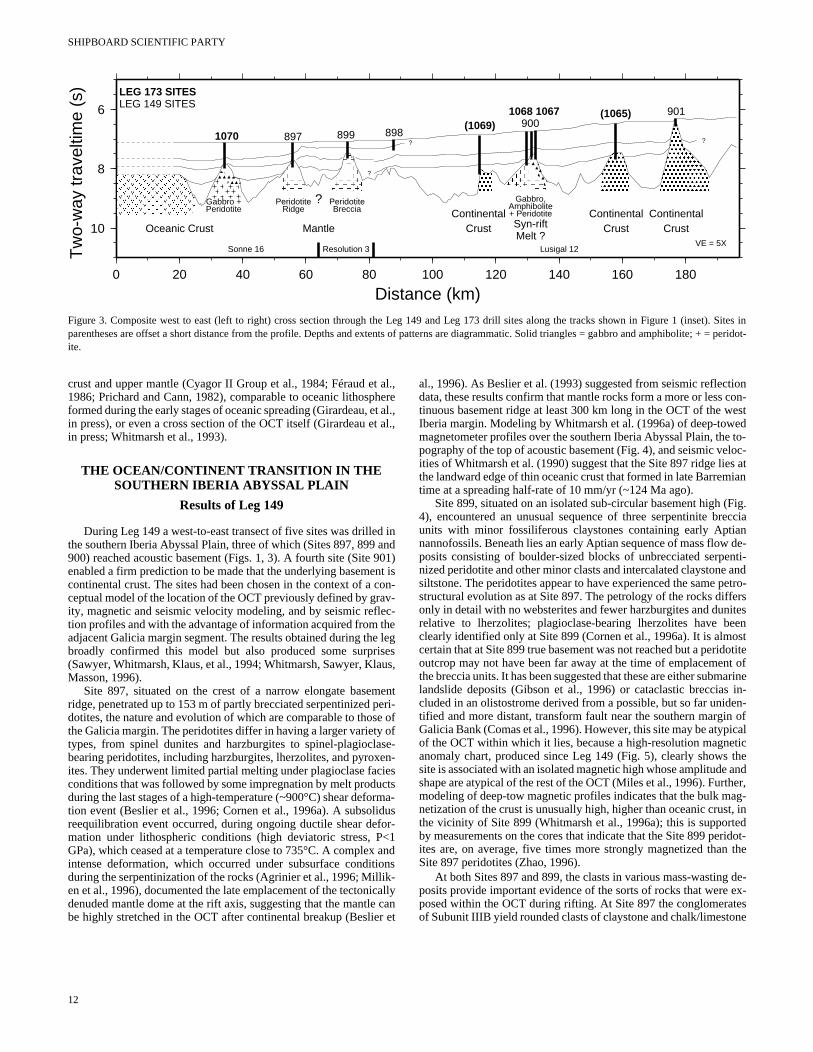
Figure 3. Composite west to east (left to right) cross section through the Leg 149 and Leg 173 drill sites along the tracks shown in Figure 1 (inset). Sites inparentheses are offset a short distance from the profile. Depths and extents of patterns are diagrammatic. Solid triangles = gabbro and amphibolite; + = peridot-ite.
t ahe
et t a
d i an90nt coavlec the liseus
mepese o
asen
cieuctrmidufo<
x aionik-icae cr e
ioncon-ested to-loc-s atian
Fig.ccian de-nti- andetro-ersitesenstotitet ofarine
in-en- oficalticthe ander,g-, inedidot- the
de-ex-esne
crust and upper mantle (Cyagor II Group et al., 1984; Féraud e1986; Prichard and Cann, 1982), comparable to oceanic lithospformed during the early stages of oceanic spreading (Girardeau, in press), or even a cross section of the OCT itself (Girardeau ein press; Whitmarsh et al., 1993).
THE OCEAN/CONTINENT TRANSITION IN THE SOUTHERN IBERIA ABYSSAL PLAIN
Results of Leg 149
During Leg 149 a west-to-east transect of five sites was drillethe southern Iberia Abyssal Plain, three of which (Sites 897, 899900) reached acoustic basement (Figs. 1, 3). A fourth site (Site enabled a firm prediction to be made that the underlying basemecontinental crust. The sites had been chosen in the context of aceptual model of the location of the OCT previously defined by grity, magnetic and seismic velocity modeling, and by seismic reftion profiles and with the advantage of information acquired fromadjacent Galicia margin segment. The results obtained during thbroadly confirmed this model but also produced some surpr(Sawyer, Whitmarsh, Klaus, et al., 1994; Whitmarsh, Sawyer, KlaMasson, 1996).
Site 897, situated on the crest of a narrow elongate baseridge, penetrated up to 153 m of partly brecciated serpentinized dotites, the nature and evolution of which are comparable to thothe Galicia margin. The peridotites differ in having a larger varietytypes, from spinel dunites and harzburgites to spinel-plagioclbearing peridotites, including harzburgites, lherzolites, and pyroxites. They underwent limited partial melting under plagioclase faconditions that was followed by some impregnation by melt prodduring the last stages of a high-temperature (~900°C) shear defotion event (Beslier et al., 1996; Cornen et al., 1996a). A subsolreequilibration event occurred, during ongoing ductile shear demation under lithospheric conditions (high deviatoric stress, PGPa), which ceased at a temperature close to 735°C. A compleintense deformation, which occurred under subsurface conditduring the serpentinization of the rocks (Agrinier et al., 1996; Millen et al., 1996), documented the late emplacement of the tectondenuded mantle dome at the rift axis, suggesting that the mantlbe highly stretched in the OCT after continental breakup (Beslie
12
l.,re
al.,l.,
nd1) isn-
--eegs,
ntri-offe--ssa-s
r-1nds
llyant
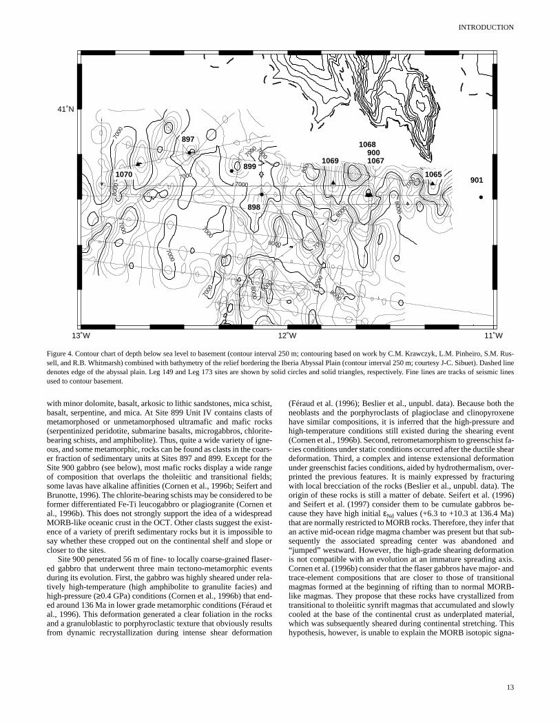
al., 1996). As Beslier et al. (1993) suggested from seismic reflectdata, these results confirm that mantle rocks form a more or less tinuous basement ridge at least 300 km long in the OCT of the wIberia margin. Modeling by Whitmarsh et al. (1996a) of deep-towmagnetometer profiles over the southern Iberia Abyssal Plain, thepography of the top of acoustic basement (Fig. 4), and seismic veities of Whitmarsh et al. (1990) suggest that the Site 897 ridge liethe landward edge of thin oceanic crust that formed in late Barremtime at a spreading half-rate of 10 mm/yr (~124 Ma ago).
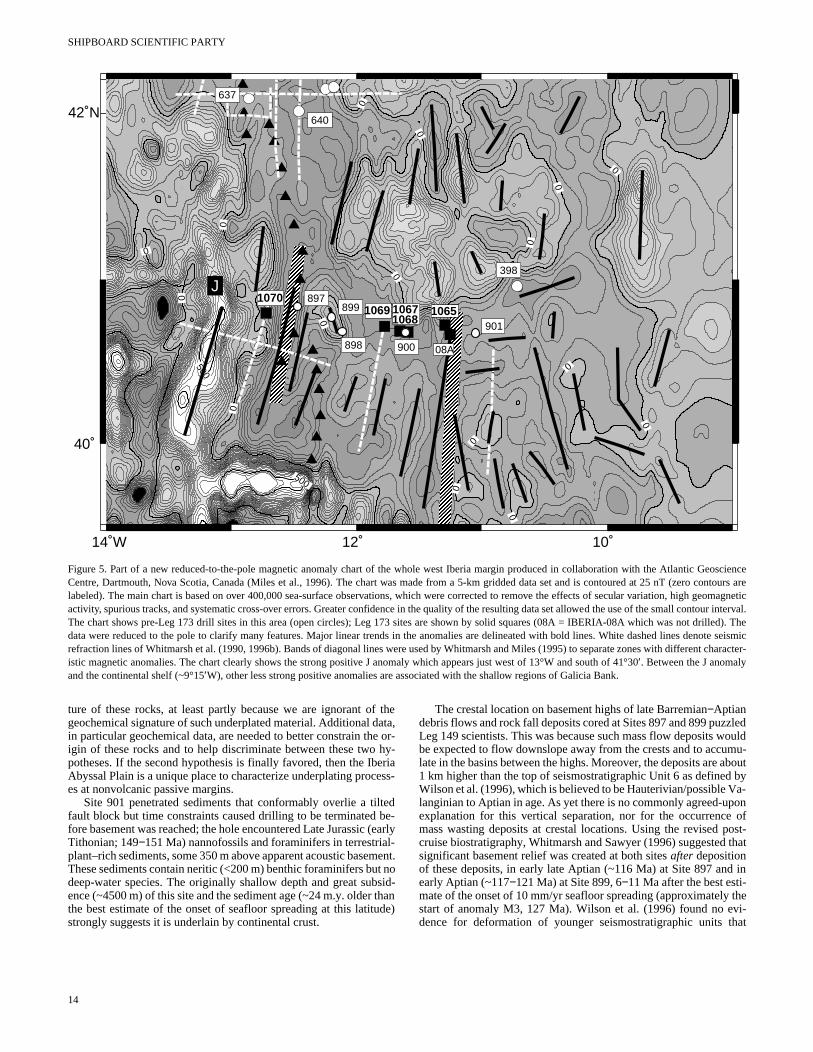
Site 899, situated on an isolated sub-circular basement high (4), encountered an unusual sequence of three serpentinite breunits with minor fossiliferous claystones containing early Aptianannofossils. Beneath lies an early Aptian sequence of mass flowposits consisting of boulder-sized blocks of unbrecciated serpenized peridotite and other minor clasts and intercalated claystonesiltstone. The peridotites appear to have experienced the same pstructural evolution as at Site 897. The petrology of the rocks diffonly in detail with no websterites and fewer harzburgites and dunrelative to lherzolites; plagioclase-bearing lherzolites have beclearly identified only at Site 899 (Cornen et al., 1996a). It is almocertain that at Site 899 true basement was not reached but a peridoutcrop may not have been far away at the time of emplacementhe breccia units. It has been suggested that these are either submlandslide deposits (Gibson et al., 1996) or cataclastic brecciascluded in an olistostrome derived from a possible, but so far unidtified and more distant, transform fault near the southern marginGalicia Bank (Comas et al., 1996). However, this site may be atypof the OCT within which it lies, because a high-resolution magneanomaly chart, produced since Leg 149 (Fig. 5), clearly shows site is associated with an isolated magnetic high whose amplitudeshape are atypical of the rest of the OCT (Miles et al., 1996). Furthmodeling of deep-tow magnetic profiles indicates that the bulk manetization of the crust is unusually high, higher than oceanic crustthe vicinity of Site 899 (Whitmarsh et al., 1996a); this is supportby measurements on the cores that indicate that the Site 899 perites are, on average, five times more strongly magnetized thanSite 897 peridotites (Zhao, 1996).
At both Sites 897 and 899, the clasts in various mass-wastingposits provide important evidence of the sorts of rocks that were posed within the OCT during rifting. At Site 897 the conglomeratof Subunit IIIB yield rounded clasts of claystone and chalk/limesto
INTRODUCTION
13˚W 12˚W 11˚W
41˚N5000
6000
7000
7000
7000
70007000
7000
7000
7000
7000
7000
7000
7000
8000
8000
8000
8000
8000
8000
8000
8000
9000
897
898
899
900
9019011065
1067
1068
1069
10701070
Figure 4. Contour chart of depth below sea level to basement (contour interval 250 m; contouring based on work by C.M. Krawczyk, L.M. Pinheiro, S.M. Rus-sell, and R.B. Whitmarsh) combined with bathymetry of the relief bordering the Iberia Abyssal Plain (contour interval 250 m; courtesy J-C. Sibuet). Dashed linedenotes edge of the abyssal plain. Leg 149 and Leg 173 sites are shown by solid circles and solid triangles, respectively. Fine lines are tracks of seismic linesused to contour basement.
dcu
tio
thexeneandent
st fa-heartionver-ringhe96) be-)hatt sub- and
tionxis.- andonalB-
fromwlyerial,Thisna-
with minor dolomite, basalt, arkosic to lithic sandstones, mica schist,basalt, serpentine, and mica. At Site 899 Unit IV contains clasts ofmetamorphosed or unmetamorphosed ultramafic and mafic rocks(serpentinized peridotite, submarine basalts, microgabbros, chlorite-bearing schists, and amphibolite). Thus, quite a wide variety of igne-ous, and some metamorphic, rocks can be found as clasts in the coars-er fraction of sedimentary units at Sites 897 and 899. Except for theSite 900 gabbro (see below), most mafic rocks display a wide rangeof composition that overlaps the tholeiitic and transitional fields;some lavas have alkaline affinities (Cornen et al., 1996b; Seifert andBrunotte, 1996). The chlorite-bearing schists may be considered to beformer differentiated Fe-Ti leucogabbro or plagiogranite (Cornen etal., 1996b). This does not strongly support the idea of a widespreadMORB-like oceanic crust in the OCT. Other clasts suggest the exist-ence of a variety of prerift sedimentary rocks but it is impossible tosay whether these cropped out on the continental shelf and slope orcloser to the sites.
Site 900 penetrated 56 m of fine- to locally coarse-grained flaser-ed gabbro that underwent three main tectono-metamorphic eventsduring its evolution. First, the gabbro was highly sheared under rela-tively high-temperature (high amphibolite to granulite facies) andhigh-pressure (≥0.4 GPa) conditions (Cornen et al., 1996b) that end-ed around 136 Ma in lower grade metamorphic conditions (Féraual., 1996). This deformation generated a clear foliation in the roand a granuloblastic to porphyroclastic texture that obviously resfrom dynamic recrystallization during intense shear deforma
etksltsn
(Féraud et al. (1996); Beslier et al., unpubl. data). Because bothneoblasts and the porphyroclasts of plagioclase and clinopyrohave similar compositions, it is inferred that the high-pressure high-temperature conditions still existed during the shearing ev(Cornen et al., 1996b). Second, retrometamorphism to greenschicies conditions under static conditions occurred after the ductile sdeformation. Third, a complex and intense extensional deformaunder greenschist facies conditions, aided by hydrothermalism, oprinted the previous features. It is mainly expressed by fractuwith local brecciation of the rocks (Beslier et al., unpubl. data). Torigin of these rocks is still a matter of debate. Seifert et al. (19and Seifert et al. (1997) consider them to be cumulate gabbroscause they have high initial εNd values (+6.3 to +10.3 at 136.4 Mathat are normally restricted to MORB rocks. Therefore, they infer tan active mid-ocean ridge magma chamber was present but thasequently the associated spreading center was abandoned“jumped” westward. However, the high-grade shearing deformais not compatible with an evolution at an immature spreading aCornen et al. (1996b) consider that the flaser gabbros have majortrace-element compositions that are closer to those of transitimagmas formed at the beginning of rifting than to normal MORlike magmas. They propose that these rocks have crystallized transitional to tholeiitic synrift magmas that accumulated and slocooled at the base of the continental crust as underplated matwhich was subsequently sheared during continental stretching. hypothesis, however, is unable to explain the MORB isotopic sig
13
SHIPBOARD SCIENTIFIC PARTY
14˚W 12˚ 10˚
40˚
42˚N
0
00
00
0
0
0
0
0
0
0
0
0
0
0
500
500
JJ
106510671068
637
640
398
89710701069
08A898
899
900
901
Figure 5. Part of a new reduced-to-the-pole magnetic anomaly chart of the whole west Iberia margin produced in collaboration with the Atlantic GeoscienceCentre, Dartmouth, Nova Scotia, Canada (Miles et al., 1996). The chart was made from a 5-km gridded data set and is contoured at 25 nT (zero contours arelabeled). The main chart is based on over 400,000 sea-surface observations, which were corrected to remove the effects of secular variation, high geomagneticactivity, spurious tracks, and systematic cross-over errors. Greater confidence in the quality of the resulting data set allowed the use of the small contour interval.The chart shows pre-Leg 173 drill sites in this area (open circles); Leg 173 sites are shown by solid squares (08A = IBERIA-08A which was not drilled). Thedata were reduced to the pole to clarify many features. Major linear trends in the anomalies are delineated with bold lines. White dashed lines denote seismicrefraction lines of Whitmarsh et al. (1990, 1996b). Bands of diagonal lines were used by Whitmarsh and Miles (1995) to separate zones with different character-istic magnetic anomalies. The chart clearly shows the strong positive J anomaly which appears just west of 13°W and south of 41°30′. Between the J anomalyand the continental shelf (~9°15′W), other less strong positive anomalies are associated with the shallow regions of Galicia Bank.
mt n
bs thtud
zledouldmu-bout bya-on
ofost-
that
in
thevi-hat
ture of these rocks, at least partly because we are ignorant of thegeochemical signature of such underplated material. Additional data,in particular geochemical data, are needed to better constrain the or-igin of these rocks and to help discriminate between these two hy-potheses. If the second hypothesis is finally favored, then the IberiaAbyssal Plain is a unique place to characterize underplating process-es at nonvolcanic passive margins.
Site 901 penetrated sediments that conformably overlie a tiltedfault block but time constraints caused drilling to be terminated be-fore basement was reached; the hole encountered Late Jurassic (earlyTithonian; 149−151 Ma) nannofossils and foraminifers in terrestrial-plant–rich sediments, some 350 m above apparent acoustic baseThese sediments contain neritic (<200 m) benthic foraminifers budeep-water species. The originally shallow depth and great suence (~4500 m) of this site and the sediment age (~24 m.y. olderthe best estimate of the onset of seafloor spreading at this latistrongly suggests it is underlain by continental crust.
14
ent.o
id-ane)
The crestal location on basement highs of late Barremian−Aptiandebris flows and rock fall deposits cored at Sites 897 and 899 puzLeg 149 scientists. This was because such mass flow deposits wbe expected to flow downslope away from the crests and to acculate in the basins between the highs. Moreover, the deposits are a1 km higher than the top of seismostratigraphic Unit 6 as definedWilson et al. (1996), which is believed to be Hauterivian/possible Vlanginian to Aptian in age. As yet there is no commonly agreed-upexplanation for this vertical separation, nor for the occurrencemass wasting deposits at crestal locations. Using the revised pcruise biostratigraphy, Whitmarsh and Sawyer (1996) suggestedsignificant basement relief was created at both sites after depositionof these deposits, in early late Aptian (~116 Ma) at Site 897 andearly Aptian (~117−121 Ma) at Site 899, 6−11 Ma after the best esti-mate of the onset of 10 mm/yr seafloor spreading (approximatelystart of anomaly M3, 127 Ma). Wilson et al. (1996) found no edence for deformation of younger seismostratigraphic units t
INTRODUCTION
elcoes
ren
onucom-
would be expected if the basement ridges had been uplifted after theAptian. Following creation of the highs, sedimentation was practical-ly insignificant (0.4 m/Ma at Site 897 and 1.3 m/Ma at Site 899) forover 60 Ma until the sites were eventually inundated by abyssal plainsediments in the early−middle Eocene.
Thus, in summary, the results of Leg 149 combined with the geo-physical data proved the existence of a peridotite ridge at the land-ward edge of the inferred oceanic crust formed by ~10 mm/yr half-rate seafloor spreading. They also showed that between this ridge andSite 901, which is situated on a fault block of almost unequivocalcontinental crust, there exists a 130-km-wide OCT, much of which isprobably underlain by a heterogeneous basement. One indication ofthe transitional nature of this basement may be the MORB-like totransitional gabbro at Site 900; other indications are the presence ofpetrogenetically transitional to alkaline mafic clasts in mass wastingdeposits at Sites 897 and 899. The magnetic and seismic reflectioncharacter and velocity structure of the basement provide additionalevidence that has been used to suggest a broad zone of subsedimentmantle outcrop (see below). Whether the Site 900 gabbro is pre- orsynrift in age, the original granulite metamorphic grade and the 40Ar/39Ar age of the end of the ductile deformation implies that the gabbrowas exhumed by important synrift tectonics that accompanied litho-spheric extension. Although Site 899 sampled a serpentinite brecciaand an underlying serpentinized peridotite mass-flow deposit, mag-netic evidence suggests that the basement of this site may be atypicalof the rest of the Iberia Abyssal Plain OCT and it may not be correctto infer continuity of peridotite basement between Sites 897 and 899.Models that explain many of these observations are presented below.Leg 173 planned to test such models by focusing on the nature andevolution of the basement itself within this zone and on the possiblemajor tectonic contacts that have been identified there.
MODELS FOR THE FORMATION OF THE OCTIN THE SOUTHERN IBERIA ABYSSAL PLAIN
Based on the Leg 149 results, the latest time- and depth-migratedseismic reflection profiles in the southern Iberia Abyssal Plain, an in-terpretation of the new magnetic anomaly chart (Fig. 5), and othergeophysical observations a series of preliminary tectonic and mag-matic models for lithospheric rifting and OCT formation on the westIberia margin has been produced since Leg 149 (Brun and Beslier,1996; Krawczyk et al., 1996; Pickup et al., 1996; Whitmarsh andSawyer, 1996). The models emphasize different processes (e.g., con-tinental stretching and breakup, or the nature and structure of theOCT formed after continental breakup), and differ in the relative im-portance attributed to the nature of the basement cores relative to thegeophysical observations, in the significance attributed to the peri-dotite ridge, and in whether the east-west distribution of differentbasement rocks within the OCT is considered to be systematic or justrandom. Such a variety of approaches was valid after Leg 149 be-cause the number of drill sites that had reached basement remainedvery small.
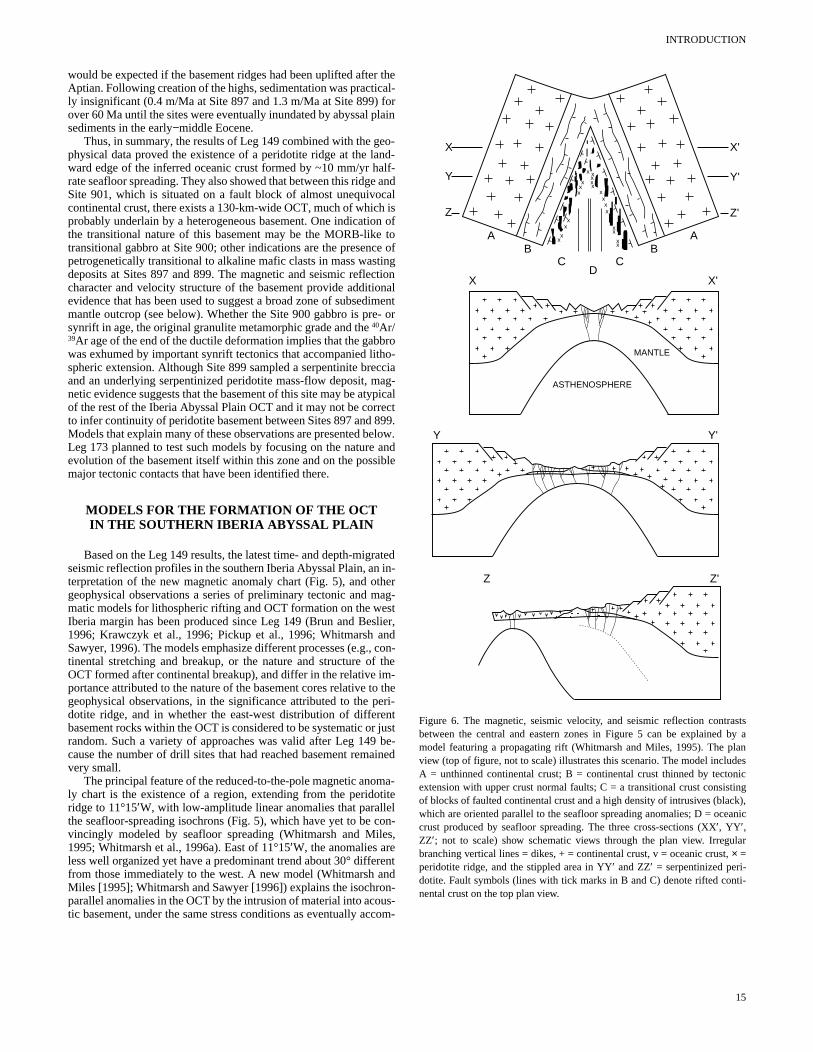
The principal feature of the reduced-to-the-pole magnetic anoma-ly chart is the existence of a region, extending from the peridotiteridge to 11°15′W, with low-amplitude linear anomalies that parallthe seafloor-spreading isochrons (Fig. 5), which have yet to be vincingly modeled by seafloor spreading (Whitmarsh and Mil1995; Whitmarsh et al., 1996a). East of 11°15′W, the anomalies areless well organized yet have a predominant trend about 30° diffefrom those immediately to the west. A new model (Whitmarsh aMiles [1995]; Whitmarsh and Sawyer [1996]) explains the isochrparallel anomalies in the OCT by the intrusion of material into acotic basement, under the same stress conditions as eventually ac
n-,
ntd-s-
X
Y
Z
ABB
CCD
A
X'
X
MANTLE
ASTHENOSPHERE
X'
Y Y'
Y'
Z'
xx
x
xx
xx
xxxxx
x
xx
xx
xx
x
Z'Z
Figure 6. The magnetic, seismic velocity, and seismic reflection contrastsbetween the central and eastern zones in Figure 5 can be explained by amodel featuring a propagating rift (Whitmarsh and Miles, 1995). The planview (top of figure, not to scale) illustrates this scenario. The model includesA = unthinned continental crust; B = continental crust thinned by tectonicextension with upper crust normal faults; C = a transitional crust consistingof blocks of faulted continental crust and a high density of intrusives (black),which are oriented parallel to the seafloor spreading anomalies; D = oceaniccrust produced by seafloor spreading. The three cross-sections (XX′, YY′,ZZ′; not to scale) show schematic views through the plan view. Irregularbranching vertical lines = dikes, + = continental crust, v = oceanic crust, × =peridotite ridge, and the stippled area in YY′ and ZZ′ = serpentinized peri-dotite. Fault symbols (lines with tick marks in B and C) denote rifted conti-nental crust on the top plan view.
15
SHIPBOARD SCIENTIFIC PARTY
100
50
050 60 70 8040 km
4000 4100 4200 4300 4400 4500 4600 4700 4800 4900 5000
4000 4100 4200 4300 4400 4500 4600 4700 4800 4900 5000
0
100
SHOT
50
7
6
8
9
10
11
12
5 km
SE
CS
EC
7
6
8
9
10
11
12
7
6
8
9
10
11
12
SE
CS
EC
7
6
8
9
10
11
12
W ELusigal-12 time migration
11 35'W
(Site 1065)
Site1068
Site1067
Site901
Site900
nTnT
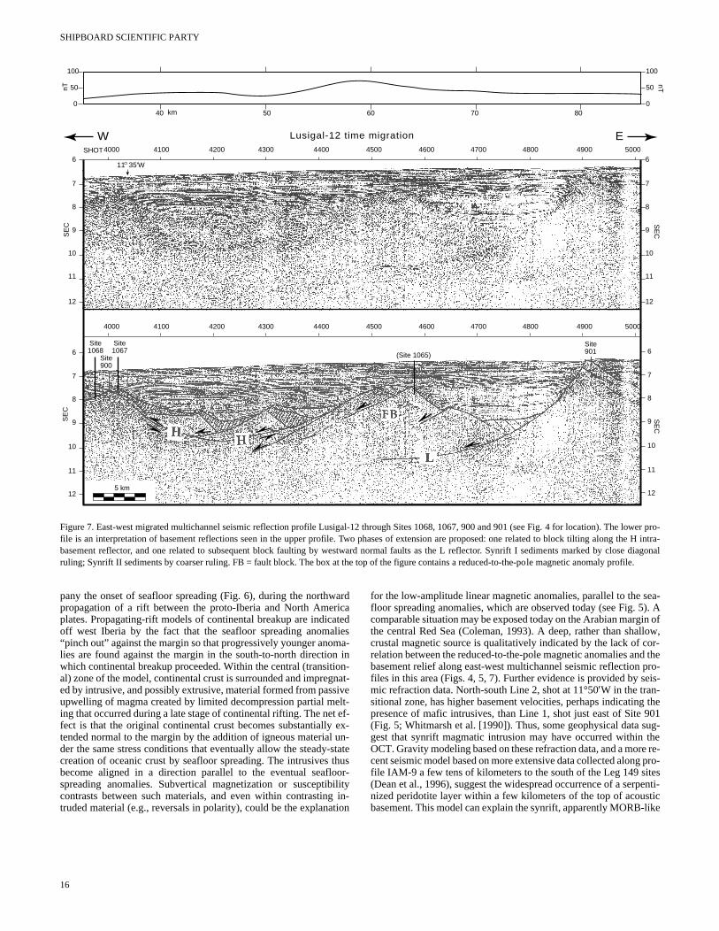
Figure 7. East-west migrated multichannel seismic reflection profile Lusigal-12 through Sites 1068, 1067, 900 and 901 (see Fig. 4 for location). The lower pro-file is an interpretation of basement reflections seen in the upper profile. Two phases of extension are proposed: one related to block tilting along the H intra-basement reflector, and one related to subsequent block faulting by westward normal faults as the L reflector. Synrift I sediments marked by close diagonalruling; Synrift II sediments by coarser ruling. FB = fault block. The box at the top of the figure contains a reduced-to-the-pole magnetic anomaly profile.
mn ion
siet e u-sthooil
g ti
sea-5). Ain ofllow,or-d the
pro-eis-
g the 901sug-there re-g pro-itespenti-sticlike
pany the onset of seafloor spreading (Fig. 6), during the northwardpropagation of a rift between the proto-Iberia and North Americaplates. Propagating-rift models of continental breakup are indicatedoff west Iberia by the fact that the seafloor spreading anomalies“pinch out” against the margin so that progressively younger anolies are found against the margin in the south-to-north directiowhich continental breakup proceeded. Within the central (transital) zone of the model, continental crust is surrounded and impreged by intrusive, and possibly extrusive, material formed from pasupwelling of magma created by limited decompression partial ming that occurred during a late stage of continental rifting. The nefect is that the original continental crust becomes substantiallytended normal to the margin by the addition of igneous materialder the same stress conditions that eventually allow the steadycreation of oceanic crust by seafloor spreading. The intrusives become aligned in a direction parallel to the eventual seaflspreading anomalies. Subvertical magnetization or susceptibcontrasts between such materials, and even within contrastintruded material (e.g., reversals in polarity), could be the explana
16
a-inn-at-velt-ef-x-n-tateusr-
ityin-on
for the low-amplitude linear magnetic anomalies, parallel to the floor spreading anomalies, which are observed today (see Fig. comparable situation may be exposed today on the Arabian margthe central Red Sea (Coleman, 1993). A deep, rather than shacrustal magnetic source is qualitatively indicated by the lack of crelation between the reduced-to-the-pole magnetic anomalies anbasement relief along east-west multichannel seismic reflectionfiles in this area (Figs. 4, 5, 7). Further evidence is provided by smic refraction data. North-south Line 2, shot at 11°50′W in the tran-sitional zone, has higher basement velocities, perhaps indicatinpresence of mafic intrusives, than Line 1, shot just east of Site(Fig. 5; Whitmarsh et al. [1990]). Thus, some geophysical data gest that synrift magmatic intrusion may have occurred within OCT. Gravity modeling based on these refraction data, and a mocent seismic model based on more extensive data collected alonfile IAM-9 a few tens of kilometers to the south of the Leg 149 s(Dean et al., 1996), suggest the widespread occurrence of a sernized peridotite layer within a few kilometers of the top of acoubasement. This model can explain the synrift, apparently MORB-
INTRODUCTION
e s n-t
Intrusions
Mantle thinning over a broad region Moho
Incipientblock-faulting
Detachmentbecomes inactiveMantle
exposureNewfoundland Iberia
Dikes
897 898 900 901
Transition zoneSeafloor spreading west ofperidotite exposure
Thinned continental crustbroken up into fault blocks,
crustal level shallows to the east
Base of fault blocks modified by ductile flow?
Structureunconstrained
Lower crust
Upper crust
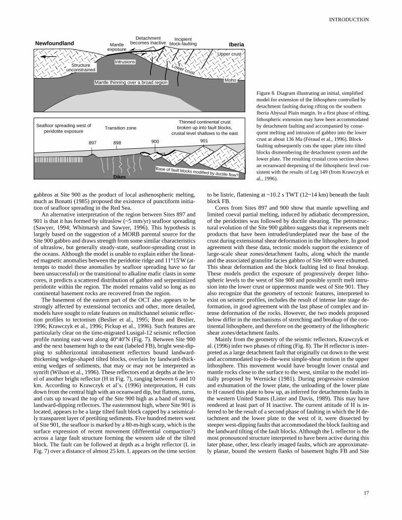
Figure 8. Diagram illustrating an initial, simplified model for extension of the lithosphere controlled by detachment faulting during rifting on the southernIberia Abyssal Plain margin. In a first phase of rifting, lithospheric extension may have been accommodated by detachment faulting and accompanied by conse-quent melting and intrusion of gabbro into the lower crust at about 136 Ma (Féraud et al., 1996). Block-faulting subsequently cuts the upper plate into tiltedblocks dismembering the detachment system and thlower plate. The resulting crustal cross section showan oceanward deepening of the lithospheric level cosistent with the results of Leg 149 (from Krawczyk eal., 1996).
ooi
toilf
ie io
-dr
cd l 1trno1i
n
ilt
c
ndon,uc-meltf theoodce ofntle
med.p.
tho-tru-heyd to de- in-sedon-eric
etr-estpernd
ini-ionatets inave in- de- byande thisate-Site
gabbros at Site 900 as the product of local asthenospheric melting,much as Bonatti (1985) proposed the existence of punctiform initia-tion of seafloor spreading in the Red Sea.
An alternative interpretation of the region between Sites 897 and901 is that it has formed by ultraslow (~5 mm/yr) seafloor spreading(Sawyer, 1994; Whitmarsh and Sawyer, 1996). This hypothesis islargely based on the suggestion of a MORB parental source for theSite 900 gabbro and draws strength from some similar characteristicsof ultraslow, but generally steady-state, seafloor-spreading crust inthe oceans. Although the model is unable to explain either the lineat-ed magnetic anomalies between the peridotite ridge and 11°15′W (at-tempts to model these anomalies by seafloor spreading have sbeen unsuccessful) or the transitional to alkaline mafic clasts in scores, it predicts a scattered distribution of gabbro and serpentinperidotite within the region. The model remains valid so long ascontinental basement rocks are recovered from the region.
The basement of the eastern part of the OCT also appears strongly affected by extensional tectonics and other, more detamodels have sought to relate features on multichannel seismic retion profiles to tectonism (Beslier et al., 1995; Brun and Besl1996; Krawczyk et al., 1996; Pickup et al., 1996). Such featuresparticularly clear on the time-migrated Lusigal-12 seismic reflectprofile running east-west along 40°40′N (Fig. 7). Between Site 900and the next basement high to the east (labeled FB), bright westping to subhorizontal intrabasement reflectors bound landwathickening wedge-shaped tilted blocks, overlain by landward-thiening wedges of sediments, that may or may not be interpretesynrift (Wilson et al., 1996). These reflectors end at depths at theel of another bright reflector (H in Fig. 7), ranging between 6 andkm. According to Krawczyk et al’s. (1996) interpretation, H cudown from the central high with an oceanward dip, but flattens, tuand cuts up toward the top of the Site 900 high as a band of strlandward-dipping reflectors. The easternmost high, where Site 90located, appears to be a large tilted fault block capped by a seismly transparent layer of pretilting sediments. Five hundred meters wof Site 901, the seafloor is marked by a 80-m-high scarp, which issurface expression of recent movement (differential compactioacross a large fault structure forming the western side of the tblock. The fault can be followed at depth as a bright reflector (LFig. 7) over a distance of almost 25 km. L appears on the time se
farmezedno
beed,lec-r,aren
ip-d-k- asev-0
ss,ng, is
cal-estthe?)edintion
to be listric, flattening at ~10.2 s TWT (12−14 km) beneath the faultblock FB.
Cores from Sites 897 and 900 show that mantle upwelling alimited coeval partial melting, induced by adiabatic decompressiof the peridotites was followed by ductile shearing. The petrostrtural evolution of the Site 900 gabbro suggests that it represents products that have been intruded/underplated near the base ocrust during extensional shear deformation in the lithosphere. In gagreement with these data, tectonic models support the existenlarge-scale shear zones/detachment faults, along which the maand the associated granulite facies gabbro of Site 900 were exhuThis shear deformation and the block faulting led to final breakuThese models predict the exposure of progressively deeper lispheric levels to the west of Site 900 and possible synrift melt insion into the lower crust or uppermost mantle west of Site 901. Talso recognize that the geometry of tectonic features, interpreteexist on seismic profiles, includes the result of intense late stageformation, in good agreement with the last phase of complex andtense deformation of the rocks. However, the two models propobelow differ in the mechanisms of stretching and breakup of the ctinental lithosphere, and therefore on the geometry of the lithosphshear zones/detachment faults.
Mainly from the geometry of the seismic reflectors, Krawczyk al. (1996) infer two phases of rifting (Fig. 8). The H reflector is intepreted as a large detachment fault that originally cut down to the wand accommodated top-to-the-west simple-shear motion in the uplithosphere. This movement would have brought lower crustal amantle rocks close to the surface to the west, similar to the modeltially proposed by Wernicke (1981). During progressive extensand exhumation of the lower plate, the unloading of the lower plto H caused this plate to bow up, as inferred for detachments faulthe western United States (Lister and Davis, 1989). This may hrendered at least part of H inactive. The current attitude of H isferred to be the result of a second phase of faulting in which the Htachment and the lower plate to the west of it, were dissectedsteeper west-dipping faults that accommodated the block faulting the landward tilting of the fault blocks. Although the L reflector is thmost pronounced structure interpreted to have been active duringlater phase, other, less clearly imaged faults, which are approximly planar, bound the western flanks of basement highs FB and
17
SHIPBOARD SCIENTIFIC PARTY
C
BLower crust shear zone
Strength (σ1 - σ3)
Depth
LCSZ
A
D
Mantle shear zone
(MSZ)
�����������������������������������������������������������������
sediments
Site 897
gabbroperidotiteper serpentinization front
tectonic windowSite 901Site 900
?
Continentalcrust
man
tlecr
ust
Moho
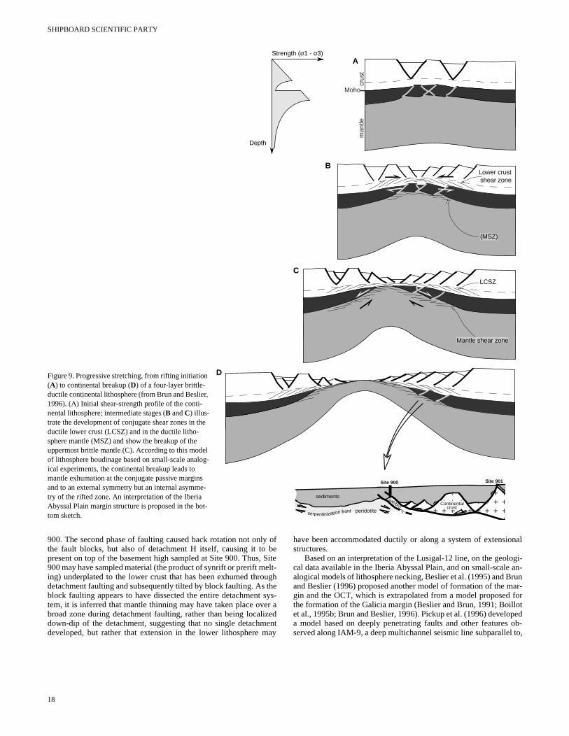
Figure 9. Progressive stretching, from rifting initiation (A) to continental breakup (D) of a four-layer brittle-ductile continental lithosphere (from Brun and Beslier, 1996). (A) Initial shear-strength profile of the conti-nental lithosphere; intermediate stages (B and C) illus-trate the development of conjugate shear zones in the ductile lower crust (LCSZ) and in the ductile litho-sphere mantle (MSZ) and show the breakup of the uppermost brittle mantle (C). According to this model of lithosphere boudinage based on small-scale analog-ical experiments, the continental breakup leads to mantle exhumation at the conjugate passive margins and to an external symmetry but an internal asymme-try of the rifted zone. An interpretation of the Iberia Abyssal Plain margin structure is proposed in the bot-tom sketch.
900. The second phase of faulting caused back rotation not only ofthe fault blocks, but also of detachment H itself, causing it to bepresent on top of the basement high sampled at Site 900. Thus, Site900 may have sampled material (the product of synrift or prerift melt-ing) underplated to the lower crust that has been exhumed throughdetachment faulting and subsequently tilted by block faulting. As theblock faulting appears to have dissected the entire detachment sys-tem, it is inferred that mantle thinning may have taken place over abroad zone during detachment faulting, rather than being localizeddown-dip of the detachment, suggesting that no single detachmentdeveloped, but rather that extension in the lower lithosphere may
18
have been accommodated ductily or along a system of extensionalstructures.
Based on an interpretation of the Lusigal-12 line, on the geologi-cal data available in the Iberia Abyssal Plain, and on small-scale an-alogical models of lithosphere necking, Beslier et al. (1995) and Brunand Beslier (1996) proposed another model of formation of the mar-gin and the OCT, which is extrapolated from a model proposed forthe formation of the Galicia margin (Beslier and Brun, 1991; Boillotet al., 1995b; Brun and Beslier, 1996). Pickup et al. (1996) developeda model based on deeply penetrating faults and other features ob-served along IAM-9, a deep multichannel seismic line subparallel to,
INTRODUCTION
m-e,
-
n
f
-o0ce of-esi--
ec0
)th
lyt
e-e-ls
B
t-
t.sr--
and a few tens of kilometers south of, the Lusigal-12 line, that in-volves lithospheric necking and the changing response to extensionof the lithosphere as it passes from a plastic to a brittle regime.
In the Brun and Beslier (1996) model, as now widely accepted fora continental lithosphere with a ~35-km-thick crust and a stable geo-therm, the initial lithosphere is assumed to present a four-layer typestrength profile (with two relatively high-strength zones correspond-ing to the middle crust and the upper part of the lithosphere mantle;Fig. 9). Stretching of such a brittle-ductile multilayered lithosphereleads to nearly symmetrical necking of the whole lithosphere (pureshear) and also to the internal development of asymmetrical struc-tures (simple shear) because of heterogeneous boudinage and/orfaulting of brittle layers (upper crust and uppermost mantle). Relativemovement between brittle layers caused by offsets between crust andmantle boudins is accommodated by layer-parallel shear in the duc-tile layers (lower crust and upper mantle) defining a set of conjugateshear zones. With increasing stretching (Fig. 9), breakup of the brittleupper mantle occurs, and lower crust and mantle shear zones becomejuxtaposed as the lower ductile mantle layer rises up through thebreakup zone. Localization of stretching in the upper part of the litho-sphere mantle produces asymmetry in the lithosphere, even if no pre-viously inherited asymmetry was present. A system of tilted blocksdevelops in the brittle crust over the ductile crustal shear zone. Ex-treme crustal thinning in the central part of the necked lithosphere re-sults in mantle exhumation. Accordingly, the exhumation of litho-spheric mantle is the result of bulk pure shear at lithospheric scale.Shearing of exhumed mantle rocks does not correspond to detach-ment faults cross-cutting the whole lithosphere at the onset of riftingbut results from heterogeneous stretching and boudinage of the high-strength uppermost mantle. Mantle rocks that appear at the extremesof the two conjugate passive margins are those that have been shearedalong mantle shear zones. The pre-existing sub-continental Mohopasses laterally toward the breakup zone into a newly formed Moho,which vertically juxtaposes the ductile mantle and the lower crust, oreven the upper brittle crust (Fig. 9). In the Iberia Abyssal Plain, the Hreflector is then interpreted as a major synrift tectonic contact that re-sults from intralithospheric shear zones that brought into contact the(upper?) crust and the underplated gabbros produced by the partialmelting of the mantle. It implies that the whole area located betweenSite 900 and the oceanic crust is a tectonic window opened on deeplithospheric levels (serpentinized peridotite and associated underplat-ed gabbros). The complex late deformation in greenschist facies con-ditions observed in both peridotite and gabbro and the considerablewidth (130 km) of the OCT suggest that the mantle and associatedmafic rocks can be stretched over a large width after the continentalbreakup is completed and before a mature accretion axis has becomeestablished.
Although currently it is hard to explain the lineated magneticanomalies in the OCT (Whitmarsh and Miles, 1995) by the above tec-tonic models, this results more from unfamiliarity with the geophys-ical characteristics that such an unusual zone would possess thanfrom any specific contrary argument.
Even though one may argue about the details of the above inter-pretations, and how some of these models could be combined to bet-ter explain both continental breakup and OCT formation, it is certain-ly possible that a major tectonic contact approaches the basement sur-face near Site 900. Further drilling took place during Leg 173 in orderto clarify the nature and petrostructural evolution of the rocks in-volved in this major synrift extensional structure and the kinematicsof the deformation, to investigate the nature of the basement in thetransition zone, to seek evidence of synrift magmatism, and to deter-mine the nature and evolution of the adjacent continental and oceaniccrusts.
SCIENTIFIC DRILLING OBJECTIVES
As outlined above, Leg 149 largely succeeded in determining theoceanward and landward bounds of the OCT in the southern IberiaAbyssal Plain. The principal problem that remained was to refineknowledge of the nature and evolution of the basement rocks andtheir relationships within the OCT itself, both for its intrinsic rele-vance to the general problem of rift-to-drift processes and to test as-pects of our best working models of these tectonic and igneous pro-cesses at the west Iberia nonvolcanic margin. Sites were thereforechosen for Leg 173 (Figs. 1, 3–5) with the following objectives:
1. To sample acoustic basement, principally within the OCT, tocharacterize those tectonic and magmatic processes that doinate the transition from continental to oceanic crust in spacand time (see Sites 901, IBERIA-07B [which became 1069]IBERIA-08B [1065], IBERIA-09A/09B [1067/1066], IBE-RIA-09C [1068], and IBERIA-10A [1070]).
2. To determine the role of simple shear deformation in the evolution of the margin. This was to be done by drilling through amajor synrift tectonic contact on the east side of the high owhich Site 900 has already been drilled. Figure 10, in whichthe H reflector can be traced almost continuously to the top othe fault block, shows this possibility particularly clearly. Thisinterpretation is supported by the retrograde evolution and intense deformation of the Site 900 gabbros from granulite tgreenschist facies conditions. The seismic image at Site 90suggests that the site could be located very close to the plawhere H intersects the acoustic basement surface, a resultlate normal faulting along the west-dipping steep fault bounding the western flank of the basement high. By offsetting somhundreds of meters to the east of Site 900, however, the posbility existed to drill through the complete shear zone/detachment. This latter site (two alternative sites, IBERIA-09A/09B[1067/1066] were proposed) was also expected to enable thmode and kinematics of the deformation along the tectonicontact to be determined and the lateral extent of the Site 90mafic rocks to be assessed. Another site (IBERIA-07B [1069]was drilled on the westernmost basement high associated wia westward-dipping listric normal fault, to test the predictionthat continental breakup led to the exposure of progressivedeeper lithospheric levels (low level crust or even uppermosmantle) westward in the OCT (see Sites IBERIA-07B [1069],IBERIA-09A/09B [1067/1066], and IBERIA-09C [1068]).
3. To determine the role and extent of synrift magmatism in thOCT basement, which is inferred to exist from the new magnetic anomaly chart and Site 900 cores. Using isotopes, to dtermine the petrogenetic origin and dates of originacrystallization and subsequent metamorphism of igneourocks (see Sites 901, IBERIA-07B [1069], IBERIA-08B[1065], IBERIA-09A/09B [1067/1066], and IBERIA-09C[1068]).
4. To sample basement beneath Site 901 or Site IBERIA-08[1065] to confirm predictions of the existence of continentalcrust there, to determine the approximate level in the crusfrom which it came, and thereby to set an unequivocal landward limit to the OCT (see Sites 901, IBERIA-08B [1065]).
5. To sample the probably atypical early-formed oceanic crusThis remains unsampled in the Iberia Abyssal Plain and itpresence and location are inferred only by geophysical obsevations. Samples from this site were expected to provide definitive evidence of the oceanic nature of the crust
19
SHIPBOARD SCIENTIFIC PARTY
n Ma
ic
He
ontio
ht
th
i
ns
rm
phrid
oth-
n.
zoE
79rm
e
J.st
s.)
loth
”ia
af-
e
,A.,rti,
lts
a
lt
s.
el-
st-
6. of
),
k
is--
fic
.,,e
nt
,a
g,
immediately (20 km) west of the peridotite ridge and, by bio-stratigraphic or isotopic dating, may enable the seafloor-spreading model to be verified. Samples were also expected toyield the possibly unusual chemistry of the thin crust formedby the earliest magma-starved seafloor spreading and providevaluable petrological information about initial melt production(cf. Site 900 gabbro), following continental breakup at a non-volcanic margin (see Site IBERIA-10A [1070]).
REFERENCES
Agrinier, P., Cornen, G., and Beslier, M.-O., 1996. Mineralogical and oxygenisotopic features of serpentinites recovered from the ocean/continenttransition in the Iberia Abyssal Plain. In Whitmarsh, R.B., Sawyer, D.S.,Klaus, A., and Masson, D.G. (Eds.), Proc. ODP, Sci. Results, 149: Col-lege Station, TX (Ocean Drilling Program), 541−552.
Agrinier, P., Mével, C., and Girardeau, J., 1988. Hydrothermal alteratiothe peridotites cored at the ocean/continent boundary of the Iberian gin: petrologic and stable isotope evidence. In Boillot, G., Winterer, E.L.,et al., Proc. ODP, Sci. Results, 103: College Station, TX (Ocean DrillingProgram), 225−234.
Allemand, P., and Brun, J.P., 1991. Width of continental rifts and rheologlayering of the lithosphere. Tectonophysics, 188:63−69.
Auzende, J.M., Charvet, J., Le Lann, A., Le Pichon, X., Monteiro, J.Nicolas, A., Olivet, J.L., and Ribeiro, A., 1979. Le Banc de Gorringrésultats de la campagne CYAGOR (août 1977). Bull. Soc. Geol. Fr.,21:545−556.
Auzende, J.-M., Olivet, J.-L., Charvet, J., Le Lann, A., Le Pichon, X., Mteiro, J.H., Nicolas, A. and Ribeiro, A., 1978. Sampling and observaof oceanic mantle and crust on Gorringe Bank. Nature, 273:45−49.
Bassi, G., 1991. Factors controlling the style of continental rifting: insigfrom numerical modelling. Earth Planet. Sci. Lett., 105:430−452.
————, 1995. Relative importance of strain rate and rheology for mode of continental extension. Geophys. J. Int., 122:195−210.
Beslier, M.O., Ask, M., and Boillot, G., 1993. Ocean-continent boundarythe Iberia Abyssal Plain from multichannel seismic data. Tectonophysics,218:383−393.
Beslier, M.O., Bitri, A., and Boillot, G., 1995. Structure de la transition cotinent-océan d’une marge passive: sismique réflexion multitrace danPlaine Abyssale Ibérique (Portugal). C. R. Acad. Sci. Ser. 2a, 320:969−976.
Beslier, M.O., and Brun, J.-P., 1991. Boudinage de la lithosphère et fotion des marges passives. C. R. Acad. Sci. Ser. 2, 313:951−958.
Beslier, M.-O., Cornen, G., and Girardeau, J., 1996. Tectono-metamorevolution of peridotites from the ocean/continent transition of the IbeAbyssal Plain margin. In Whitmarsh, R.B., Sawyer, D.S., Klaus, A., anMasson, D.G. (Eds.), Proc. ODP, Sci. Results, 149: College Station, TX(Ocean Drilling Program), 397−412.
Beslier, M.O., Girardeau, J., and Boillot, G., 1990. Kinematics of peridemplacement during North Atlantic continental rifting, Galicia, nortwestern Spain. Tectonophysics, 184:321−343.
Boillot, G., Agrinier, P., Beslier, M.-O., Cornen, G., Froitzheim, N., GardieV., Girardeau, J., Gil-Ibarguchi, J.-I., Kornprobst, J., Moullade, MSchaerer, U., and Vanney, J.-R., 1995a. A lithospheric syn-rift shear at the ocean-continent transition: preliminary results of the GALINAUTII cruise (Nautile dives on the Galicia Bank, Spain). C. R. Acad. Sci. Ser2a, 321:1171−1178.
Boillot, G., Auxiètre, J., Dunand, J., Dupeuble, P., and Mauffret, A., 19The northwestern Iberian margin: a Cretaceous passive margin defoduring Eocene. In Talwani, M., Hay, W., and Ryan, W.B.F. (Eds.), DeepDrilling Results in the Atlantic Ocean: Continental Margin and Paleoen-vironment. Am. Geophys. Union, Maurice Ewing Ser., 3:138−153.
Boillot, G., Beslier, M.O., and Comas, M., 1992. Seismic image of undcrusted serpentinite beneath a rifted margin. Terra Nova, 4:25−33.
Boillot, G., Beslier, M.O., Krawczyk, C.M., Rappin, D., and Reston, T.1995b. The formation of passive margins: constraints from the crustructure and segmentation of the deep Galicia margin (Spain). In Scrut-ton, R.A., Stocker, M.S., Shimmield, G.B., and Tudhope, A.W. (EdThe Tectonics, Sedimentation and Palaeoceanography of the NorthAtlantic Region. Geol. Soc. Spec. Publ. London, 90:71−91.
Boillot, G., Comas, M.C., Girardeau, J., Kornprobst, J., Loreau, J.-P., MaJ., Mougenot, D., and Moullade, M., 1988a. Preliminary results of
20
ofr-
al
.,:
-n
s
e
n
- la
a-
ica
e
,,ne
.ed
r-
,al
,
d,e
Galinaute cruise: dives of the submersible Nautile on the Western GaliciaMargin, Spain. In Boillot, G., Winterer, E.L., et al., Proc. ODP, Sci.Results, 103: College Station, TX (Ocean Drilling Program), 37−51.
Boillot, G., Féraud, G., Recq, M., and Girardeau, J., 1989. “Undercrustingby serpentinite beneath rifted margins: the example of the west Galicmargin (Spain). Nature, 341:523−525.
Boillot, G., Girardeau, J., and Kornprobst, J., 1988b. Rifting of the GaliciMargin: crustal thinning and emplacement of mantle rocks on the sealoor. In Boillot, G., Winterer, E.L., et al., Proc. ODP, Sci. Results, 103:College Station, TX (Ocean Drilling Program), 741−756.
Boillot, G., Grimaud, S., Mauffret, A., Mougenot, D., Kornprobst, J., Mer-goil-Daniel, J., and Torrent, G., 1980. Ocean-continent boundary off thIberian margin: a serpentinite diapir west of the Galicia Bank. EarthPlanet. Sci. Lett., 48:23−34.
Boillot, G., Recq, M., Winterer, E.L., Meyer, A.W., Applegate, J., Baltuck,M., Bergen, J.A., Comas, M.C., Davies, T.A., Dunham, K., Evans, C.A.Girardeau, J., Goldberg, D.G., Haggerty, J., Jansa, L.F., Johnson, J.Kasahara, J., Loreau, J.-P., Luna-Sierra, E., Moullade, M., Ogg, J., SaM., Thurow, J., and Williamson, M.A., 1987. Tectonic denudation of theupper mantle along passive margins: a model based on drilling resu(ODP Leg 103, western Galicia margin, Spain). Tectonophysics,132:335−342.
Boillot, G., Winterer, E.L., et al., 1988. Proc. ODP, Sci. Results, 103: CollegeStation, TX (Ocean Drilling Program).
Boillot, G., Winterer, E.L., Meyer, A.W., et al., 1987. Proc. ODP, Init. Repts.,103: College Station, TX (Ocean Drilling Program).
Bonatti, E., 1985. Punctiform initiation of seafloor spreading in the Red Seduring transition from a continental to an oceanic rift. Nature, 316:33−37.
Bown, J.W., and White, R.S., 1995. The effect of finite extension rate on megeneration at continental rifts. J. Geophys. Res., 100:18011−18030.
Brun, J.P., and Beslier, M.-O., 1996. Mantle exhumation at passive marginEarth Planet. Sci. Lett., 142:161−173.
Brun, J.-P., Sokoutis, D., and van den Driessche, J., 1994. Analogue moding of detachment fault systems and core complexes. Geology, 22:319−322.
Capdevila, R., and Mougenot, D., 1988. Pre-Mesozoic basement of the weern Iberian continental margin and its place in the Variscan Belt. In Boil-lot, G., Winterer, E.L., et al., Proc. ODP, Sci. Results, 103: CollegeStation, TX (Ocean Drilling Program), 3−12.
Coleman, R.G., 1993. Geological Evolution of the Red Sea: New York(Oxford Univ. Press).
Comas, M.C., Sánchez-Gómez, M., Cornen, G., and de Kaenel, E., 199Serpentinized peridotite breccia and olistrostrome on basement highsthe Iberia Abyssal Plain: implications for tectonic margin evolution. InWhitmarsh, R.B., Sawyer, D.S., Klaus, A., and Masson, D.G. (Eds.Proc. ODP, Sci. Results, 149: College Station, TX (Ocean Drilling Pro-gram), 577−591.
Cornen, G., 1982. Petrology of the alkaline volcanism of Gorringe Ban(southwest Portugal). Mar. Geol., 47:101−130.
Cornen, G., Beslier M.-O., and Girardeau, J., 1996a. Petrologic charactertics of the ultramafic rocks from the ocean/continent transition in the Iberia Abyssal Plain. In Whitmarsh, R.B., Sawyer, D.S., Klaus, A., andMasson, D.G. (Eds.), Proc. ODP, Sci. Results, 149: College Station, TX(Ocean Drilling Program), 377−395.
Cornen, G., Beslier, M.-O., and Girardeau, J., 1996b. Petrology of the marocks cored in the Iberia Abyssal Plain. In Whitmarsh, R.B., Sawyer,D.S., Klaus, A., and Masson, D.G. (Eds.), Proc. ODP, Sci. Results, 149:College Station, TX (Ocean Drilling Program), 449−469.
Cyagor II Group (Auzende, J.M., Ceuleneer, G., Cornen, G., Juteau, TLagabrielle, Y., Lensch, G., Mével, C., Nicolas, A., Prichard, H., RibeiroA., Ruellan, E., and Vanney, J.R.), 1984. Intraoceanic tectonism on thGorringe Bank: observations by submersible. In Gass, I.G., Lippard S.J.,and Shelton, A.W. (Eds.), Ophiolites and Oceanic Lithosphere. Geol.Soc. London, 113−120.
Cyagor Group, 1977. Le Banc de Gorringe (S-O du Portugal): un fragmede croute et manteau océanique reconnu par submersible. C.R. Acad. Sci.Ser. D, 285:1403−1406.
Dean, S.M., Minshull, T.A., Whitmarsh, R.B., Louden, K., and Chian, D.1996. A seismic study of the ocean-continent transition in the IberiAbyssal Plain. Eos, 77:F668.
de Charpal, O., Guennoc, P., Montadert, L., and Roberts, D.G., 1978. Riftincrustal attenuation and subsidence in the Bay of Biscay. Nature,275:706−711.
INTRODUCTION
e G
le
gd
.M
inp
cM.G
s
isti
,
g
te
thp
n
t
vrs-
or
n
onti-
m-ten-
ting
cross
so-
nicrth-
the
is-
er,ean-
een
en-
icagusvey.
tary
tern
etic,
fssal
G.
.-C.,ub-,
uf-in
f the
ique
96.ria
de Graciansky, P.C., Poag, C.W., et al., 1985. Init. Repts. DSDP, 80: Wash-ington (U.S. Govt. Printing Office).
Dupeuble, P.-A., Boillot, G., and Mougenot, D., 1987. Upper Jurassic-lowestCretaceous limestones dredged from the Western Galicia Margin. InBoillot, G., Winterer, E.L., et al., Proc. ODP, Init. Repts., 103: CollegeStation, TX (Ocean Drilling Program), 99−106.
Dupeuble, P.A., Réhault, J.P., Auxiètre, J.L., Dunand, J.P., and Pastour1976. Résultats de dragages et essai de stratigraphie des bancs deet des montagnes de Porto et de Vigo (marge occidentale iberique).Mar.Geol., 22:37−49.
Evans, C.A., and Girardeau, J., 1988. Galicia Margin peridotites: undepabyssal peridotites from the North Atlantic. In Boillot, G., Winterer, E.L.,et al., Proc. ODP, Sci. Results, 103: College Station, TX (Ocean DrillingProgram), 195−207.
Féraud, G., Beslier, M.-O., and Cornen, G., 1996. 40Ar/39Ar dating of gab-bros from the ocean/continent transition of the western Iberia Marpreliminary results. In Whitmarsh, R.B., Sawyer, D.S., Klaus, A., anMasson, D.G. (Eds.), Proc. ODP, Sci. Results, 149: College Station, TX(Ocean Drilling Program), 489−495.
Féraud, G., York, D., Mével, C., Cornen, G., Hall, C.M., and Auzende, J1986. Additional 40Ar-39Ar dating of the basement and the alkaline vocanism of the Gorringe Bank (Atlantic Ocean). Earth Planet. Sci. Lett.,79:255−269.
Froitzheim, N., and Manatschal, G., 1996. Kinematics of Jurassic riftmantle exhumation, and passive margin formation in the Austroaland Penninic nappes (eastern Switzerland). Geol. Soc. Am. Bull.,108:1120−1133.
Gibson, I.L., Milliken, K.L., and Morgan, J.K., 1996. Serpentinite-breclandslide deposits generated during crustal extension at the Iberia gin. In Whitmarsh, R.B., Sawyer, D.S., Klaus, A., and Masson, D(Eds.), Proc. ODP, Sci. Results, 149: College Station, TX (Ocean DrillingProgram), 571−575.
Girardeau, J., Cornen, G., Agrinier, P., Beslier, M.O., Dubuisson, G., Le GB., Monnier, C., Pinheiro, L., Ribeiro, A., and Whitechurch, H., in preRésultats des plongées du Nautile sur le Banc de Gorringe. C.R. Acad.Sci. Ser. 2.
Girardeau, J., Evans, C.A., and Beslier, M.-O., 1988. Structural analysplagioclase-bearing peridotites emplaced at the end of continental rifHole 637A, ODP Leg 103 on the Galicia Margin. In Boillot, G., Winterer,E.L., et al., Proc. ODP, Sci. Results, 103: College Station, TX (OceanDrilling Program), 209−223.
Gradstein, F.M., Agterberg, F.P., Ogg, J.G., Hardenbol, J., van VeenThierry, J., and Huang, Z., 1995. A Triassic, Jurassic and Cretaceousscale. In Berggren, W.A., Kent, D.V., and Aubry, M.P. (Eds.), Geochro-nology, Time Scales and Global Stratigraphic Correlation. Spec. Publ.—Soc. Econ. Paleontol. Mineral., 54:95−128.
Groupe Galice, 1979. The continental margin off Galicia and Portuacoustical stratigraphy, dredge stratigraphy, and structural evolutionInSibuet, J.-C., Ryan, W.B.F., et al., Init. Repts. DSDP, 47 (Pt. 2): Washing-ton (U.S. Govt. Printing Office), 633−662.
Harry, D.L., and Sawyer, D.S., 1992. A dynamic model of lithospheric exsion in the Baltimore Canyon Trough region. Tectonics, 11:420−436.
Hinz, K., Winterer, E.L., et al., 1984. Init. Repts. DSDP, 79: Washington(U.S. Govt. Printing Office).
Hoffman, H.-J., and Reston, T.J., 1992. Nature of the S reflector beneaGalicia Banks rifted margin: preliminary results from pre-stack demigration. Geology, 20:1091−1094.
Horsefield, S.J., 1992. Crustal structure across the continent-ocean bou[Ph.D. thesis]. Cambridge Univ.
Klitgord, K.D., and Schouten, H., 1986. Plate kinematics of the cenAtlantic. In Vogt, P.R., and Tucholke, B.E. (Eds.), The Geology of NorthAmerica (Vol. M): The Western North Atlantic Region. Geol. Soc. Am.,351−378.
Krawczyk, C.M., Reston, T.J., Beslier, M.-O., and Boillot, G., 1996. Edence for detachment tectonics on the Iberia Abyssal Plain rifted maIn Whitmarsh, R.B., Sawyer, D.S., Klaus, A., and Masson, D.G. (EdProc. ODP, Sci. Results, 149: College Station, TX (Ocean Drilling Program), 603−615.
Lemoine, M., Tricart, P., and Boillot, G., 1987. Ultramafic and gabbrocean floor of the Ligurian Tethys (Alps, Corsica, Apennines): in seaof a genetic model. Geology, 15:622−625.
Le Pichon, X., and Barbier, F., 1987. Passive margin formation by low-afaulting within the upper crust: the northern Bay of Biscay margin. Tec-tonics, 6:133−150.
t, L.,alice
ted
in:
.,l-
g,ine
iaar-.
all,s.
ofng:
P.,time
al:.
n-
theth
dary
ral
i-gin..),
icch
gle
Le Pichon, X., Sibuet, J.C., and Francheteau, J., 1977. The fit of the cnents around the North Atlantic Ocean. Tectonophysics, 38:169−209.
Lister, G.S., and Davis, G.A., 1989. The origin of metamorphic core coplexes and detachment faults formed during Tertiary continental exsion in the Northern Colorado River region, U.S.A. J. Struct. Geol.,11:65−94.
Lister, G.S., Etheridge, M.A., and Symonds, P.A., 1986. Detachment fauland evolution of passive continental margins. Geology, 14:246−250.
Louden, K., Sibuet, J.C., and Foucher, J.P., 1989. Heat flow anomalies aGoban Spur and Galicia Bank continental margins (NW Atlantic). Eos,70:1328.
Malod, J.A., and Mauffret, A., 1990. Iberian plate motion during the Mezoic. In Boillot, G., and Fontbote, J.M. (Eds.), Alpine Evolution of Iberiaand its Continental Margins. Tectonophysics, 184:261−278.
Malod, J.A., Murillas, J., Kornprobst, J., and Boillot, G., 1993. Ocealithosphere at the edge of a Cenozoic active continental margin (nowestern slope of Galicia Bank, Spain). Tectonophysics, 221:195−206.
Mamet, B., Comas, M.C., and Boillot, G., 1991. Late Paleozoic basin onWest Galicia Atlantic margin. Geology, 19:738−741.
Martins, L.F., 1991. Activitade igneo Mesozoica em Portugal [Ph.D. dsert.]. Univ. of Lisbon, Portugal.
Masson, D.G., Cartwright, J.A., Pinheiro, L.M., Whitmarsh, R.B., BesliM.-O., and Roeser, H., 1994. Compressional deformation at the occontinent transition in the NE Atlantic. J. Geol. Soc. London, 151:607−613.
Masson, D.G., and Miles, P.R., 1984. Mesozoic seafloor spreading betwIberia, Europe and North America. Mar. Geol., 56:279−287.
Mauffret, A., and Montadert, L., 1987. Rift tectonics on the passive contintal margin off Galicia (Spain). Mar. Pet. Geol., 4:49−70.
————, 1988. Seismic stratigraphy off Galicia. In Boillot, G., Winterer,E.L., et al., Proc. ODP, Sci. Results, 103: College Station, TX (OceanDrilling Program), 13−30.
Mauffret, A., Mougenot, D., Miles, P.R., and Malod, J.A., 1989. Cenozodeformation and Mesozoic abandoned spreading centre in the Tabyssal plain (west of Portugal): results of a multichannel seismic surCan. J. Earth Sci., 26:1101−1123.
McKenzie, D., 1978. Some remarks on the development of sedimenbasins. Earth Planet. Sci. Lett., 40:25−32.
Mével, C., 1988. Metamorphism of oceanic layer 3, Gorringe Bank, easAtlantic. Contrib. Mineral. Petrol., 100:496−509.
Miles, P.R., Verhoef, J., and Macnab, R., 1996. Compilation of magnanomaly chart west of Iberia. In Whitmarsh, R.B., Sawyer, D.S., KlausA., and Masson, D.G. (Eds.), Proc. ODP, Sci. Results, 149: College Sta-tion, TX (Ocean Drilling Program), 659−663.
Milliken, K.L., Lynch, F.L., and Seifert, K.E., 1996. Marine weathering oserpentinites and serpentinite breccias, Site 897 and 899, Iberia AbyPlain. In Whitmarsh, R.B., Sawyer, D.S., Klaus, A., and Masson, D.(Eds.), Proc. ODP, Sci. Results, 149: College Station, TX (Ocean DrillingProgram), 529−540.
Montadert, L., de Charpel, O., Roberts, D., Guennoc, P., and Sibuet, J1979a. Northeast Atlantic passive continental margins: rifting and ssidence processes. In Talwani, M., Hay, W., and Ryan, W.B.F. (Eds.)Deep Drilling Results in the Atlantic Ocean: Continental Margins andPaleoenvironment. Am. Geophys. Union, Maurice Ewing Ser., 3:154−186.
Montadert, L., Roberts, D.G., et al., 1979b. Init. Repts. DSDP, 48: Washing-ton (U.S. Govt. Printing Office).
Murillas, J., Mougenot, D., Boillot, G., Comas, M.C., Banda, E., and Mafret, A., 1990. Structure and evolution of the Galicia Interior bas(Atlantic western Iberian continental margin). Tectonophysics, 184:297−319.
Ogg, J.G., 1988. Early Cretaceous and Tithonian magnetostratigraphy oGalicia Margin (Ocean Drilling Program Leg 103). In Boillot, G., Win-terer, E.L., et al., Proc. ODP, Sci. Results, 103: College Station, TX(Ocean Drilling Program), 659−682.
Olivet, J.L., 1996. La cinématique de la plaque ibérique. Bull. Cent. Rech.Explor.-Prod. Elf-Aquitaine, 20:131−195.
Olivet, J.L., Bonnin, J., Beuzart, P., and Auzende, J.M., 1984. Cinématde l’Atlantique nord et central. Publ. Cent. Natl Exploit. Oceans, Rapp.Sci. Tech., 54:108−112.
Pickup, S.L.B., Whitmarsh, R.B., Fowler, C.M.R., and Reston, T.J., 19Insight into the nature of the ocean-continent transition off West Ibefrom a deep multichannel seismic reflection profile. Geology, 24:1079−1082.
21
SHIPBOARD SCIENTIFIC PARTY
.
r
, eli
ce
y las-
Dl
lan
.slii,
gic
n
p
, s
dl
.Cp
arytic
iledrt I.and
e ofust
ov-
st.
ion
he
ntre
gi-ons
ar-.
.,nd
ionr-
96.
ndti-
ec-
ell,sal.
nd
Pinheiro, L.M., Whitmarsh, R.B., and Miles, P.R., 1992. The ocean-continentboundary off the western continental margin of Iberia, II. Crustal struc-ture in the Tagus Abyssal Plain. Geophys. J., 109:106−124.
Pinheiro, L.M., Wilson, R.C.L., Pena dos Reis, R., Whitmarsh, R.B., andRibeiro, A., 1996. The western Iberia Margin: a geophysical and geolog-ical overview. In Whitmarsh, R.B., Sawyer, D.S., Klaus, A., and Masson,D.G. (Eds.), Proc. ODP, Sci. Results, 149: College Station, TX (OceanDrilling Program), 3−23.
Prichard, H.M., and Cann, J.R., 1982. Petrology and mineralogy of dredgedgabbro from Gettysburg Bank, Eastern Atlantic. Contrib. Mineral.Petrol., 79:46−55.
Reston, T.J., Krawczyk, C.M., and Hoffmann, H.J., 1995. Detachment tec-tonics during Atlantic rifting: analysis and interpretation of the S reflec-tion, the west Galicia margin. In Scrutton, R.A. (Ed.), Tectonics of theNorth Atlantic Region. Geol. Soc. Spec. Publ. London.
Reston, T.J., Krawczyk, C.M., and Klaeschen, D., 1996. The S reflector westof Galicia (Spain). Evidence for detachment faulting during continentalbreakup from prestack depth migration. J. Geophys. Res., 101:8075−8091.
Ribeiro, A., Antunes, M.T., Ferreira, M.P., Rocha, R.B., Soares, A.F.,Zbyszewski, G., Moitinho de Almeida, F., Carbalho, D., and Monteiro,J.H., 1979. Introduction à la Géologie Generale du Portugal: Lisboa (Ed.Serv. Geol. de Portugal).
Shipboard Scientific Party, 1973. Gorringe Bank: Site 120. In Ryan, W.B.F.,and Hsü, K.J., et al., Init. Repts. DSDP., 13: Washington (U.S. GovtPrinting Office), 19−41.
Sawyer, D.S., 1994. The case for slow-spreading oceanic crust landwathe peridotite ridge in the Iberia Abyssal Plain. Eos, 75:616.
Sawyer, D.S., Whitmarsh, R.B., Klaus, A., et al., 1994. Proc. ODP, Init.Repts., 149: College Station, TX (Ocean Drilling Program).
Schärer, U., Kornprobst, J., Beslier, M.O., Boillot, G., and Girardeau1995. Gabbro and related rock emplacement beneath rifting contincrust: U-Pb geochronological and geochemical constraints for the Gapassive margin (Spain). Earth Planet. Sci. Lett., 130:187−200.
Seifert, K., and Brunotte, D., 1996. Geochemistry of weathered mid-oridge basalt and diabase clasts from Hole 899B. In Whitmarsh, R.B.,Sawyer, D.S., Klaus, A., and Masson, D.G. (Eds.), Proc. ODP, Sci.Results, 149: College Station, TX (Ocean Drilling Program), 497−515.
Seifert, K., Gibson, I., Weis, D., and Brunotte, D., 1996. Geochemistrmetamorphosed cumulate gabbros from Hole 900A, Iberia Abyssal PIn Whitmarsh, R.B., Sawyer, D.S., Klaus, A., and Masson, D.G. (EdProc. ODP, Sci. Results, 149: College Station, TX (Ocean Drilling Program), 471−488.
Seifert, K.E., Cheng-Wen, C., and Brunotte, D.A., 1997. Evidence from OLeg 149 mafic igneous rocks for oceanic crust in the Iberia Abyssal Pocean-continent transition zone. J. Geophys. Res., 102:7915−7928.
Serri, G., Hébert, R., and Hekinian, R., 1988. Petrology of a plagiocbearing olivine websterite from the Gorringe Bank (northeastern AtlaOcean). Can. J. Earth Sci., 25:557−569.
Sibuet, J.-C., Louvel, V., Whitmarsh, R.B., White, R.S., Horsefield, SSichler, B., Leon, P., and Recq, M., 1995. Constraints on rifting procefrom refraction and deep-tow magnetic data: the example of the Gacontinental margin (West Iberia). In Banda, E., Torné, M., and TalwanM. (Eds.), Rifted Ocean-Continent Boundaries: Amsterdam (Kluwer),197−218.
Sibuet, J.-C., Mazé, J.-P., Amortila, P., and Le Pichon, X., 1987. Physiophy and structure of the Western Iberian Continental Margin off Galfrom Sea Beam and seismic data. In Boillot, G., Winterer, E.L., Meyer,A.W., et al., Proc. ODP, Init. Repts., 103: College Station, TX (OceaDrilling Program), 77−98.
Sibuet, J.-C., Ryan, W.B.F., et al., 1979. Init. Repts. DSDP, 47 (Pt. 2): Wash-ington (U.S. Govt. Printing Office).
Sibuet, J.-C., and Srivastava, S., 1994. Rifting consequences of threeseparation. Geophys. Res. Lett., 21:521−524.
Srivastava, S.P., Roest, W.R., Kovacs, L.C., Oakey, G., Lévesque, S.hoef, J., and Macnab, R., 1990a. Motion of Iberia since the Late Juraresults from detailed aeromagnetic measurements in the NewfounBasin. Tectonophysics, 184:229−260.
Srivastava, S.P., Schouten, H., Roest, W.R., Klitgord, K.D., Kovacs, LVerhoef, J., and Macnab, R., 1990b. Iberian plate kinematics: a jumplate boundary between Eurasia and Africa. Nature, 344:756−759.
22
d of
J.,ntalcia
an
ofin..),
Pain
se-tic
J.,sescia
ra-ia,
late
Ver-sic:and
.,ing
Srivastava, S.P., and Verhoef, J., 1992. Evolution of Mesozoic sedimentbasins around the North Central Atlantic: a preliminary plate kinemasolution. In Parnell, J. (Ed.), Basins of the Atlantic Seaboard: PetroleumGeology, Sedimentology and Basin Evolution. Geol. Soc. Spec. Publ.London, 62:397−420.
Srivastava, S.P., Verhoef, J., and Macnab, R., 1988. Results from a detaaeromagnetic survey across the northeast Newfoundland margin, PaSpreading anomalies and relationship between magnetic anomalies the ocean-continent boundary. Mar. Pet. Geol., 5:306−323.
Welsink, H.J., Srivastava, S.P., and Tankard, A.J., 1989. Basin architecturthe Newfoundland continental margins and its relationship to ocean crfabric during extension. In Tankard, A.J., and Balkwill, H.R. (Eds.),Extensional Tectonics and Stratigraphy of the North Atlantic Margins.AAPG Mem., 46:197−213.
Wernicke, B., 1981. Low-angle normal faults in the Basin and Range Prince: nappe tectonics in an extending orogen. Nature, 291:645−647.
————, 1985. Uniform sense normal simple shear of the continental cruCan. J. Earth Sci., 22:108−125.
Wernicke, B., and Burchfiel, B.C., 1982. Modes of extensional tectonics.J.Struct. Geol., 4:105−115.
White, R., and McKenzie, D., 1989. Magmatism at rift zones: the generatof volcanic continental margins and flood basalts. J. Geophys. Res.,94:7685−7729.
Whitmarsh, R.B., and Miles, P.R., 1995. Models of the development of tWest Iberia rifted continental margin at 40°30′N deduced from surfaceand deep-tow magnetic anomalies. J. Geophys. Res., 100:3789−3806.
Whitmarsh, R.B., Miles, P.R., and Mauffret, A., 1990. The ocean-contineboundary off the western continental margin of Iberia, I. Crustal structuat 40°30′N. Geophys. J. Int., 103:509−531.
Whitmarsh, R.B., Miles, P.R., Sibuet, J.-C., and Louvel, V., 1996a. Geolocal and geophysical implications of deep-tow magnetometer observatinear Sites 897, 898, 899, 900, and 901 on the west Iberia continental mgin. In Whitmarsh, R.B., Sawyer, D.S., Klaus, A., and Masson, D.G(Eds.), Proc. ODP, Sci. Results, 149: College Station, TX (Ocean DrillingProgram), 665−674.
Whitmarsh, R.B., Pinheiro, L.M., Miles, P.R., Recq, M., and Sibuet, J.C1993. Thin crust at the western Iberia ocean-continent transition aophiolites. Tectonics, 12:1230−1239.
Whitmarsh, R.B., and Sawyer, D.S., 1996. The ocean/continent transitbeneath the Iberia Abyssal Plain and continental-rifting to seafloospreading processes. In Whitmarsh, R.B., Sawyer, D.S., Klaus, A., andMasson, D.G. (Eds.), Proc. ODP, Sci. Results, 149: College Station, TX(Ocean Drilling Program), 713−733.
Whitmarsh, R.B., Sawyer, D.S., Klaus, A., and Masson, D.G. (Eds.), 19Proc. ODP, Sci. Results, 149: College Station, TX (Ocean Drilling Pro-gram).
Whitmarsh, R.B., White, R.S., Horsefield, S.J., Sibuet, J.-C., Recq, M., aLouvel., V., 1996b. The ocean-continent boundary off the western connental margin of Iberia: crustal structure west of Galicia Bank. J. Geo-phys. Res., 101:28291−28314.
Wilson, R.C.L., Hiscott, R.N., Willis, M.G., and Gradstein, F.M., 1989. ThLusitanian Basin of west-central Portugal: Mesozoic and Tertiary tetonic, stratigraphic and subsidence history. In Tankard, A.J., and Balk-will, H.R. (Eds.), Extensional Tectonics and Stratigraphy of the NorthAtlantic Margins. AAPG Mem., 46:341−361.
Wilson, R.C.L., Sawyer, D.S., Whitmarsh, R.B., Zerong, J., and CarbonJ., 1996. Seismic stratigraphy and tectonic history of the Iberia AbysPlain. In Whitmarsh, R.B., Sawyer, D.S., Klaus, A., and Masson, D.G(Eds.), Proc. ODP, Sci. Results, 149: College Station, TX (Ocean DrillingProgram), 617−633.
Zhao, X., 1996. Magnetic signatures of peridotite rocks from Sites 897 a899 and their implications. In Whitmarsh, R.B., Sawyer, D.S., Klaus, A.,and Masson, D.G. (Eds.), Proc. ODP, Sci. Results, 149: College Station,TX (Ocean Drilling Program), 431−446.
Ms 173IR-101
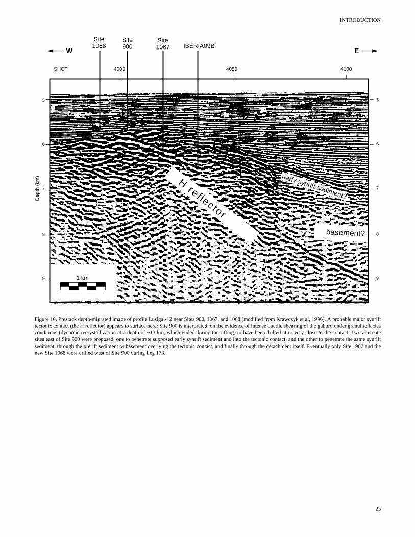
INTRODUCTION
1 km
5
6
7
8
9
5
6
7
8
9
Dep
th (
km)
H ref lector
early synrift sediment?
basement?
4000SHOT 4050 4100
Site1067
Site900 IBERIA09B
Site1068
W E
Figure 10. Prestack depth-migrated image of profile Lusigal-12 near Sites 900, 1067, and 1068 (modified from Krawczyk et al, 1996). A probable major synrifttectonic contact (the H reflector) appears to surface here: Site 900 is interpreted, on the evidence of intense ductile shearing of the gabbro under granulite faciesconditions (dynamic recrystallization at a depth of ~13 km, which ended during the rifting) to have been drilled at or very close to the contact. Two alternatesites east of Site 900 were proposed, one to penetrate supposed early synrift sediment and into the tectonic contact, and the other to penetrate the same synriftsediment, through the prerift sediment or basement overlying the tectonic contact, and finally through the detachment itself. Eventually only Site 1967 and thenew Site 1068 were drilled west of Site 900 during Leg 173.
23


![Chapter 173-505 WAClawfilesext.leg.wa.gov/law/WACArchive/2018a/WAC 173... · (8/26/05) [Ch. 173-505 WAC p. 1] Chapter 173-505 Chapter 173-505 WAC INSTREAM RESOURCES PROTECTION AND](https://img.pdfslide.us/doc/110x75/5f3d87ebe97fec5dee3cba18/chapter-173-505-173-82605-ch-173-505-wac-p-1-chapter-173-505-chapter.jpg)