Embed Size (px)
Citation preview

1Florida Division of Emergency Management
Richard ButgereitGIS Administrator850-413-9907
Roy DunnRegion Coordinators Team Leader850-519-6749
Donald KunishDeputy Chief Preparedness850-413-9921
GATOR

GATOR• The Geospatial Assessment Tool for Operations and Response, or GATOR, is the flagship common operation picture/situational awareness application for the Division and the Florida State Emergency Response Team
• GATOR is an interactive web mapping tool for the display of geographic information to support emergency preparedness, operations, and response. Real-time data like weather radar, weather watches and warnings, storm reports and tracks are displayed along with base map data like roads, facilities, aerial photographs and data from operations and response.

GATOR and the DeepwaterHorizon Response

RECON
•

Air RECON

Marine RECON

• SERT RECON Report application
RECON Reports
- Existing application for the SERT RECON Team- Built primarily for hurricanes and floods- Teams trained in use, reports triaged by RECON liaisons- For this response, used to track reports of tar balls, recoverable product, shoreline and boom conditions

RECON Reports in GATOR
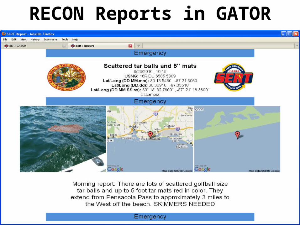
RECON Reports in GATOR

Shoreline Cleanup• Tool spun up specifically for the Branches to allow them to develop tasking in response to RECON and other reports, as well as indicate status of cleanup activities
- Tool rapidly developed and deployed, with significant feedback from the Situation Units of Branches 1 and 2.- Reporting and boom/skimming operations tools to come.

Shoreline Cleanup

Virtual USA• How was Virtual USA used to support our efforts with the Deepwater Horizon Response?

GATOR and the DeepwaterHorizon Response

Virtual USA

GATOR - Today