Embed Size (px)
Citation preview

Hydrogeological Atlas of Faryab Province, Afghanistan Version F 1.0 July 2014
1. Introduction
1. Faryab Province: A History of Water Resources Faryab Province straddles several steep topographic, meteorological and geological gradients. The southern portion of the Province is dominated by the high topography of the Safed Koh / Band-e Turkestan mountains of the Hindu Kush: temperatures are modest and winter snow and rain provide adequate supplies of fresh water.
Towards the north, the lowland semi-desert plains of Oxiana predominate, underlain by the molasse-like and alluvial erosional deposits of the Hindu Kush uplift. The climate becomes more severe, with high evapotranspiration and limited rainfall. Water resources become scarcer and what water can be found is brackish. The northern portion of Faryab has thus been a marginal environment for human habitation during recent centuries.
Faryab not only occupies a physiographical and climatic divide, it also represents a cultural and political transition, between the Afghan and Persian heartlands to the south and the plains of Central Asia to the north. The semi-desert area north of the mountains and around the Amu Darya River (or Oxos) has often been referred to historically as Oxiana or Turkestan.
Maimana had been a prominent city since the early Islamic era, when it had been known in Arabic as al-Yahudiyya (city of the Jews - Lee 1987). It was destroyed during the Mongolian invasions of Turkestan and subsequently became a khanate that was a bone of contention between the Persians and Afghans to the south and the Turkic powers (such as the Emirate of Bokhara) to the north. From 1893 onwards, Maimana became a province of Afghanistan, with an Afghan governor.
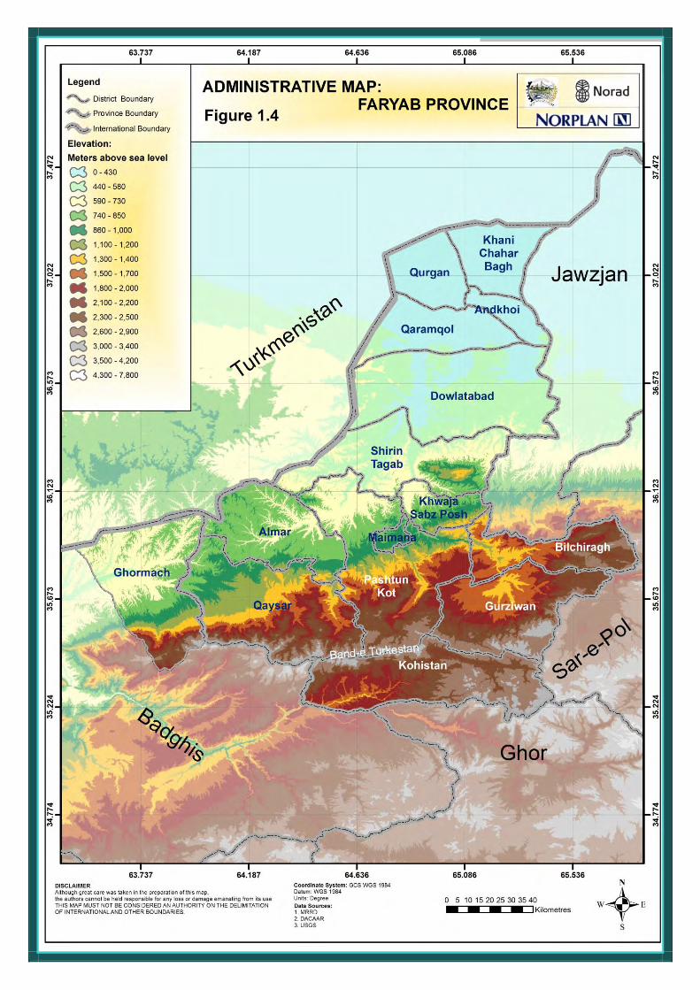
Today, Faryab has an area of 20,293 km2 a population of around 948,000, of which 114,000 are classified as “urban” and 834,000 are “rural” (CSO 2013). The Province is subdivided into 14 districts (Figure 1.4), as follows:
Table 1.1. The Districts of Faryab Province (as of 2013)
District Population (CSO 2013) Area (km2) (Wikipedia) Qaysar 138,400 2,502 Almar 68,300 1,525 Kohistan 53,100 2,254 Gurziwan 73,700 1,875 Pashtun Kot 183,500 4,000 Khwaja Sabz Posh 49,400 800 Bilchiragh 50,700 1,189 Maimana 78,500 133** Shirin Tagab 79,100 3,500 Dowlatabad 47,200 2,598 Qaramqol 19,100 2,192 Qurgan 45,800 797 Andkhoi 38,700 381 Khani Chahar Bagh 22,500 1,056 Ghormach 52,566* 2,083
* Ghormach has been included in this Atlas, as there has been some recent discussion as to whether to transfer this district from Badghis to Faryab. The district’s population was 52,566 in 2003, according to http://en.wikipedia.org/wiki/Ghormach_District
** Calculated in Google Earth

Hydrogeological Atlas of Faryab Province, Afghanistan Version F 1.0 July 2014
1. Introduction
A large proportion of the population, especially in rural districts, are from Uzbek or Turkmen linguistic groups, with significant numbers of Tajiks and Pashtuns, and a minority of Hazaras.
1.1 Vámbéry’s (1865) Travels in Central Asia When Arminius Vámbéry described his 1863 travels to the area in his Reise in Mittelasien, Maimana was a somewhat precarious khanate loyal to Turkestan. Indeed, Maimana was regarded as offering a first line of defence to any attempt on Bokhara from the south.
Vámbéry entered Faryab from the north. He described the country between Zeid and Andkhoi as “one dry barren plain, only occasionally producing a sort of thistle, the favourite fodder of the camels”. Vámbéry encamped at Khani Chahar Bagh and remarked of Andkhoi that “it is astonishing what a quantity of fruit, corn and rice is raised in this desert-like neighbourhood, only scantily watered by a little salt stream (the Shirin Tagab) flowing hither from Maymene. In summer, a stranger finds the water - to the execrable taste of which the inhabitants are accustomed - quite undrinkable...it is said to produce many other evil consequences”. Vámbéry cites an old Persian verse:
Andkhuy has bitter salt water, scorching sand, venomous flies and even scorpions; Vaunt it not, for it is the picture of a real hell.
In 1865, Vámbéry notes that a mere 30 years previously, Andkhoi had been a thriving city of 50,000 souls, with a widespread export of sheepskins and camels. Andkhoi, then a khanate in its own right, had subsequently been subsumed by Bokhara and forced to resist incursions by Afghans from the south. Caught between the jaws of Maimana, Bokhara and the Afghans, it had diminished to a ruinous town of 2000 houses and maybe 3000 tents in the surrounding area, with a total population of some 15,000.
Vámbéry progressed south via Khairabad, Bad Qaq and Akkale towards Maimana, strategically located at the boundary between the plains and mountains. Vámbéry found Maimana to be a fortified town of some 1500 dwellings, inhabited by Afghans, Uzbeks, Tadjiks, Heratis, Jews and Hindus, with markets trading in horses, carpets, raisins, aniseed and pistachio. His journey continued via Almar, Nahrin, Qaysar, Chechaktu and on across the mountains to the valley of Bala (Upper) Murghab (Figure 1.5).
1.2 Byron’s (1937) Road to Oxiana In 1933, some 70 years after Vámbéry, the irascible Robert Byron journeyed through Persia and Afghanistan to Oxiana. He entered Faryab via Bala Murghab, Karez (which he regarded as the beginning of “Turkestan”), Bukhara Qala and Maimana. He compared Maimana to the Wiltshire uplands of England, with strings of villages along a meandering river, flanked by mulberry and apricot trees. For Byron, the transition to semi-desert seemed to take place around Faizabad, where the landscape became lower, barren and sandy. The Governor of Maimana at that time described the ground as “cooked” between Faizabad and Mazar-e-Sharif, until one reached the fertile banks of the Amu Darya.
Like Vámbéry, Byron described Andkhoi as the centre of the lambskin (karakul and arabi) trade. Beyond (NE of) Andkhoi, Byron found the Oxianan landscape “colourless and suburban”, turning progressively from “leaden” to the colour of aluminium.
1.3 Irrigation In recent times, the situation has not changed so much. The main use of water in Faryab Province is for irrigation - much of this comes from the main rivers themselves (Figure 1.1).

Hydrogeological Atlas of Faryab Province, Afghanistan Version F 1.0 July 2014
1. Introduction
Anecdotally, ever greater “takes” of water for irrigation have led to less and less water reaching Andkhoi in the summer months. Indeed, at Araba, a major irrigation channel takes the majority of the Shirin Tagab river’s flow, leading it north to the Dowlatabad area, leaving the natural watercourse almost dry at some times of year (Figures 1.2, 1.3).
Groundwater from springs and wells is also used in lesser quantities for irrigation and, historically, karezes (also called qanats or aflaaj in Arabia) were used to provide irrigation in many parts of Afghanistan. These karezes are horizontal adits, skimming groundwater from just below the water table in foothill areas and leading it several hundred metres, or even kilometres, to a point of use. In the last two decades, these karezes have fallen into disuse (Shobair & Alim 2004), as a result of:
damage or lack of maintenance during the many years of civil war,
disruption of social customs and management systems for irrigation usage, often traditionally coordinated by a village mirab (Thomas & Ahmad 2009), and
in some cases, natural drought periods or the exploitation of deeper, pumped boreholes lowering the water table and drying up shallow karezes or dug wells (Banks 2001, Banks & Soldal 2002).
The economy of Faryab is based partly on livestock (cattle, sheep, goats, donkeys, occasionally camels), but largely on irrigated agriculture. Crops include wheat, barley,
maize, potatoes and flax in fields, with fruit, nuts, vegetables, alfalfa, clover and (especially in Qaysar) grapes being cultivated in garden plots. Cotton, sesame and (in Almar, Qaysar and Gurziwan) tobacco are also produced as commodities. There was also a small (4% of rural population) opium poppy activity reported in 2005 (MRRD 2007).
Of the Shirin Tagab catchment area, around 40% is classified as rangeland, 36% is amenable to rain-fed agriculture while some 7.2% is irrigated (Ibrekk et al. 2006). Of the rural population of Faryab, around 81% had access to rain-fed land in 2005, with 37% having access to irrigated land (MRRD 2007). In the 1980s, Lee (1987) was able to write that “There is still much semi-sedentary farming in the outlying areas, and during the summer many villages in Gurziwan are empty except for older men and the sick, the rest of the community have moved to the summer pastures and lalmi or non-irrigated lands where they grow their summer wheat and pitch their yurts and tents near a convenient source of water.”
Although Qureshi (2002) cites data suggesting that karezes may have previously been a significant source of irrigation water in Faryab, his graphic materials suggest that canals are responsible for by far the largest area of irrigated land. During the NORPLAN surveys of 2013, no operational karezes were registered in Faryab (although the survey did not cover all areas or districts).
Table 1.2. Land cover in the catchments of the Murghab River in Afghanistan and the Shirin Tagab, after Favre & Kamal (2004).
Land cover % of Murghab catchment
% of Shirin Tagab catchment
Rangeland (grass / low shrubs) 84.1 40.4 Rain-fed crops 12.9 35.8 Irrigated (intermittent) 1.4 4.7 Irrigated (intensive, 1 crop/year) 1.1 2.6 Irrigated (intensive, 2 crops/year) 0.01 - Sand (semi desert) - 15.5 Fruit trees 0.00 0.5

Hydrogeological Atlas of Faryab Province, Afghanistan Version F 1.0 July 2014
1. Introduction
1.4 Potable Water Supply Groundwater, from springs, dug wells and boreholes, is a significant source of potable water supply throughout Faryab. Rainwater catchments, draining into subsurface storage cisterns, are also widely used in the northern, salinised, semi-desert areas of the Province. Where local supplies of fresh water are not available, a water transport economy typically operates, whereby water can be purchased from bulk vendors, who collect water from fresh sources and transport it to consumers.
Saline Groundwater
There are three areas in the Province where saline groundwater has been a major issue:
1. the Shor Darya Valley (See Chapter 8), where both the Shor Darya river itself and the adjacent groundwaters are highly saline (river water >6000 µS/cm in the Shor Darya). The main sources of potable water in this area (from which water is distributed by donkey or camel) are:
the large Ateh Khan Khwaja spring, on the right bank of the Shor Darya, at the confluence of the Maimana and Qaysar Rivers, with a discharge of some 15-25 L/s and an electrical conductivity of only some 2660 µS/cm (Hassan Saffi 2010b).
the Shirin Tagab river itself, with an electrical conductivity of <1000 µS/cm, but highly vulnerable to faecal microbial contamination (Hassan Saffi 2010b).
2. the Astana Valley, where both the Astana river itself (up to 45,000 µS/cm - Hassan Saffi 2010a) and the adjacent groundwaters are highly saline. The main sources of potable water in this area are:
springs at Moghaito, on the southern flanks of a Cretaceous / Palaeozoic limestone/sandstone inlier, with discharges of around 3 L/s and an electrical conductivity of only some 3400-4500 µS/cm (Hassan Saffi 2010a).
the Shirin Tagab river itself.
3. the area north of Faizabad and, in particular, the city of Andkhoi and surrounding urban areas. The groundwater is typically brackish in this area, and the surface water in the Shirin Tagab and its distributary irrigation canals is also brackish, contaminated and scarce, especially in the summer months. Alternative sources of potable water in this area include:
a few wells or boreholes (typically located near irrigation ditches) where somewhat less brackish groundwater can be got (it is surmised that these may be recharged from irrigation canal infiltration).
desalination (by electrically-powered reverse osmosis) of saline groundwater from dug wells. The NGO Norwegian Church Aid has been especially active in piloting such plants, although some question marks hang over the long-term technical and economic sustainability of such a strategy.
collection of rainwater, as run-off from surface water catchments, into subsurface storage cisterns (marked вдхр. on old Soviet maps).
collection and transport of water from distant sources, such as Shirin Tagab district, which is the northernmost district where relatively fresh groundwater can be got. A water trade, based on transport and sale of water collected from fresh sources, is in operation.

Hydrogeological Atlas of Faryab Province, Afghanistan Version F 1.0 July 2014
1. Introduction
Piped Groundwater Schemes
Government ministries or NGOs have constructed a number of piped water networks throughout the province. These are typically rather modest in size and are based either on pumped (motorised) boreholes, or on spring-fed reservoirs, from which water is distributed under gravity. Amongst the motorised borehole schemes that supply piped networks, the following are prominent:
The Bibi Aina motorised borehole (c. 204 m deep) and pipe network scheme in northern Maimana;
The Torpakhto motorised borehole scheme, in northern Maimana;
The Arzolik and Sar Asyab schemes in Qaysar (145 and 150 m deep, respectively);
The Nughayli Bala and Bish Qara / Nughayli Payan schemes in Almar district (150 and 122 m deep respectively).
A present, no piped network scheme covers the majority of Maimana city. Three new test boreholes have recently been drilled in the Maimana River valley just south of Maimana city (Figure 1.5), although full details of the performance of these have not been available to this project.
Examples of gravity-fed spring discharge schemes exist at
Mershakar / Shahqasime in Pashtun Qot;
Hawze Maran in Kohistan;
two of the Moghaito springs, feeding Moghaito village and other villages in the Astana region of Shirin Tagab district (Hassan Saffi 2010a).
Import of Water to Andkhoi
In recent years, a major engineering project was contracted by the Government for the construction of a pipeline, carrying fresh groundwater from a well-field on the southern bank of the Amu Darya river, located a short distance NW of Kelif, across the desert to Andkhoi (MUMTAZ 2007 - Figure 3.13). Several of these wells yielded relatively fresh calcium bicarbonate water of total dissolved solids <1000 mg/L, and in some cases <500 mg/L. This project appears to have been unsuccessful, allegedly due to issues with pipeline materials’ quality and interference with the pipeline.
It is possibly worth noting that such large scale import of water to an urban area such as Andkhoi is fraught with difficulty unless an adequate disposal route can be identified. The import of water would likely lead to increased infiltration to the ground, via pit latrines, pipe leakages and irrigation. It would thus potentially lead to a rise in water table and further salinisation of groundwater, as salts are leached out of the unsaturated zone by the rising groundwater. It could even lead to problems with groundwater inundation if allowed to continue unchecked. Such a scenario is recorded from many areas of the world where water has been imported to arid city environments, most notably in Riyadh, Saudi Arabia (Kreibich & Thieken 2008).
Of Etymological Interest
The name Faryab is believed to mean irrigated land.

Hydrogeological Atlas of Faryab Province, Afghanistan Version F 1.0 July 2014
1. Introduction
Figure 1.1. Irrigation pumps on the River Shirin Tagab at Char Shengo, Dowlatabad District. Photo taken by DACAAR on 12th May2013.
Figure 1.2. Irrigation channel, fed by water drawn from the River Shirin Tagab, near Araba, Dowlatabad District. Photo taken by DACAAR on 12th May2013.

Hydrogeological Atlas of Faryab Province, Afghanistan Version F 1.0 July 2014
1. Introduction
Figure 1.3. The channel of the River Shirin Tagab at Araba (Dowlatabad District), heavily depleted by the upstream offtake of irrigation water (Figure 1.2). Photo taken by DACAAR on 12th May2013.
Hydrogeological Atlas of Faryab Province, Afghanistan Version F 1.0 July 2014
1. Introduction

Hydrogeological Atlas of Faryab Province, Afghanistan Version F 1.0 July 2014
1. Introduction
Figure 1.5. Physiography of Faryab Province, showing selected settlements


![Updated: July 2019152022 El Loa [Province: Chile] 152023 Tocopilla [Province: Chile] 152031 Copiapó [Province: Chile] 152032 Chañaral [Province: Chile] 152033 Huasco [Province: Chile]](https://img.pdfslide.us/doc/110x75/606b7161db19f317917da583/updated-july-2019-152022-el-loa-province-chile-152023-tocopilla-province-chile.jpg)