Embed Size (px)
Citation preview

1
ENERGY AND ENVIRONMENT CABINET 1
Department for Environmental Protection 2
Division of Water 3
(Amendment) 4
401 KAR 10:026. Designation of uses of surface waters. 5
RELATES TO: KRS 146.200-146.360, 146.410-146.535, 146.550-146.570, 146.600-6
146.619, 146.990, 224.01-010, 224.01-400, 224.16-050, 224.16-070, 224.70-100-224.70-140, 7
224.71-100-224.71-145, 224.73-100 -224.73-120[, EO 2008-507, 2008-531] 8
STATUTORY AUTHORITY: KRS 146.220, 146.241, 146.270, 146.410, 146.450, 146.460, 9
146.465, 224.10-100, 224.16-050, 224.16-060, 224.70-100, 224.70-110, 40 C.F.R. Part 131, 16 10
U.S.C. 1271-1287, 1531-1544, 33 U.S.C. 1311, 1313, 1314, 1316, 1341 11
NECESSITY, FUNCTION, AND CONFORMITY: KRS 224.10-100 requires the cabinet to 12
develop and conduct a comprehensive program for the management of water resources and to 13
provide for the prevention, abatement, and control of pollution. This administrative regulation 14
and 401 KAR 10:001, 10:029, 10:030, and 10:031 establish procedures to protect the surface 15
waters of the Commonwealth, and thus protect water resources.[EO 2008-507 and 2008-531, 16
effective June 16, 2008, abolish the Environmental and Public Protection Cabinet and establish 17
the new Energy and Environment Cabinet.] This administrative regulation applies the designated 18
uses described in 401 KAR 10:031 to the surface waters of the Commonwealth. This 19
administrative regulation also makes all surface waters subject to the general criteria specified in 20
401 KAR 10:031, Section 2. 21

2
Section 1. Scope of Designation. (1) Surface waters listed in this administrative regulation 1
shall be designated for all legitimate uses contained in KRS 224.70-100(1) except as specified in 2
401 KAR 10:031, Sections 5 and 8, or until redesignated in accordance with the procedures of 3
this administrative regulation. 4
(2) Designated uses are: 5
(a) Warm water aquatic habitat; 6
(b) Cold water aquatic habitat; 7
(c) Primary contact recreation; 8
(d) Secondary contact recreation; 9
(e) Domestic water supply; and 10
(f) Outstanding state resource water. 11
(3) Listed waters shall meet all criteria applicable to their designated uses and those criteria 12
listed in 401 KAR 10:031, Section 2, unless the cabinet grants an exception pursuant to 401 13
KAR 10:031, Section 10 or 11. 14
(4) Outstanding state resource waters may have unique water quality characteristics that shall 15
be protected by additional criteria established in 401 KAR 10:031, Section 8. 16
Section 2. Redesignation of Surface Water Uses. 17
(1) (a) Surface waters may be redesignated only upon affirmative findings by the cabinet 18
pursuant to Sections 3 and 4 of this administrative regulation. 19
(b) Before redesignating a surface water, the cabinet shall provide notice and an opportunity 20
for a public hearing. 21
(2) In redesignating a surface water, the cabinet shall ensure that its water quality standards 22
provide for the attainment and maintenance of the water quality standards of downstream surface 23

3
waters. 1
(3) A designated use shall not be removed for a surface water if that use is an existing use, or 2
if the use may be attained by implementing effluent limitations required under Sections 301(b) 3
and 306 of the Clean Water Act, 33 U.S.C. 1311(b) and 1316, and by implementing cost-4
effective best management practices for nonpoint source control. 5
(4) If a surface water is designated for a use that is not an existing use, the cabinet shall 6
redesignate the surface water upon demonstration that the designated use is unattainable because: 7
(a) Naturally occurring pollutant concentrations prevent the attainment of the use; 8
(b) Natural, ephemeral, intermittent, or low flow conditions or water levels prevent the 9
attainment of the use, unless these conditions may be compensated for by the discharge of 10
sufficient volume of effluent discharges; 11
(c) Human caused conditions or sources of pollution prevent the attainment of the use and 12
cannot be remedied or would cause more environmental damage to correct than to leave in place; 13
(d) Dams, diversions, or other types of hydrologic modifications preclude the attainment of 14
the use, and it is not feasible to restore the surface water to its original condition or to operate the 15
modification in a way that would result in the attainment of the use; 16
(e) Physical conditions related to the natural features of the surface water, but unrelated to 17
water quality, preclude attainment of the aquatic life use, such as the lack of a proper substrate, 18
cover, flow, depth, pools, or riffles; or 19
(f) Controls more stringent than those required by Sections 301(b) and 306 of the Clean 20
Water Act, 33 U.S.C. 1311(b) and 1316, would result in substantial and widespread economic 21
and social impact as determined by the guidelines in Interim Economic Guidance for Water 22
Quality Standards Workbook, EPA, March 1995. 23

4
(5) Redesignations shall be consistent with the antidegradation provisions of 401 KAR 1
10:029 and 10:030. 2
Section 3. Documentation for Redesignations. (1)(a) A person may request redesignation of 3
surface water uses by petition to the cabinet. 4
(b) The petitioner shall provide the cabinet with the documentation required in subsection (3) 5
of this section and shall have the burden of proof that the redesignation is appropriate. 6
(2)(a) The cabinet may propose redesignations of surface water uses. 7
(b) The cabinet shall provide documentation for those surface waters that it proposes for use 8
redesignation. 9
(3) Documentation to support the redesignation of a surface water of the Commonwealth 10
shall be: 11
(a) A United States Geological Survey 7.5 minute topographic map or its equivalent showing 12
those surface waters to be redesignated, with a description consisting of a river mile index with 13
existing and proposed discharge points; 14
(b) Existing uses and water quality data for the surface waters for which the redesignation is 15
proposed. If adequate data are unavailable, additional studies shall be required by the cabinet; 16
(c) Descriptions of general land uses and specific land uses adjacent to the surface waters for 17
which the redesignation is proposed; 18
(d) The existing and designated uses of the downstream waters into which the surface water 19
under consideration discharges; 20
(e) General physical characteristics of the surface water including width, depth, bottom 21
composition, and slope; 22
(f) The frequency of occasions when there is no natural flow in the surface water and the 23

5
7Q10 and harmonic mean flow values for the surface water and adjacent surface waters; 1
(g) An assessment of the existing and potential aquatic life habitat in the surface waters 2
under consideration and the adjacent upstream surface waters. 3
1. The existing aquatic life shall be documented and livestock and natural wildlife 4
dependence on the surface water shall be assessed. 5
2. The occurrence of individuals or populations, indices of diversity and well-being, and 6
abundance of species of [any]unique native biota shall be documented; 7
(h) The proposed designated uses for the surface water in question; and 8
(i) An explanation of the irretrievable person-induced, or natural conditions that preclude 9
attainment of a higher use designation or an assessment of the substantial and widespread social 10
and economic impacts resulting from the imposition of additional controls necessary for existing 11
point sources, beyond the most stringent effluent limitation levels normally required for the 12
sources. 13
Section 4. Procedures for Redesignation. 14
(1) For each of the surface waters for which a redesignation is proposed, the cabinet or 15
petitioner shall prepare a fact sheet containing the following information: 16
(a) The name and address of the petitioner; 17
(b) The name and sketch or description of the surface water proposed for specified use 18
redesignations, including the location of existing and proposed dischargers; 19
(c) The proposed use redesignations; 20
(d) A brief abstract of the supportive documentation, which demonstrates that the 21
redesignation is appropriate; 22
(e) The appropriate water quality criteria for the surface water based on the proposed 23

6
designated use; 1
(f) The treatment requirements proposed for discharges to the surface water in question if 2
designated for the proposed use; and 3
(g) A "plain English" summary of the implications of the designation for the community and 4
other users or potential users of the surface water in question. 5
(2) The cabinet shall document the determination to propose or deny redesignation as a result 6
of a petition, and shall provide a copy of the decision to the petitioner and other interested 7
parties. 8
Section 5. Surface Water Use Designations. 9
(1) Listed in the tables in this administrative regulation[below] are the use designations for 10
specific surface waters of the Commonwealth. The county column indicates the county in which 11
the mouth or outlet of the surface water is located. The identifying symbols for use designations 12
are listed in table A of this section. 13
Table A: Use Designation Symbols
WAH Warm Water Aquatic Habitat
CAH Cold Water Aquatic Habitat
PCR Primary Contact Recreation
SCR Secondary Contact Recreation
DWS Domestic Water Supply, applicable at existing
points of public water supply intake
OSRW Outstanding State Resource Water
(2)(a) Surface waters not specifically listed in this section are designated for the uses of 14
warm water aquatic habitat, primary contact recreation, secondary contact recreation and 15

7
domestic water supply in accordance with Section 1 of this administrative regulation. 1
(b) Domestic water supply criteria in 401 KAR 10:031, Section 6, are implemented at 2
locations listed in Table B in this paragraph. 3
Table B: SURFACE WATER INTAKES FOR DOMESTIC WATER SUPPLY USE
Name Description County
BIG SANDY RIVER BASIN
[Elkhorn City Water
Department
Mile 13.7 of Russell Fork Pike]
Paintsville Utilities
Commission
Mile 38.9 of Levisa Fork Johnson
Louisa Municipal Water
Works
Mile 27.35 [0.6] of Levisa Fork Lawrence
Prestonsburg City Utilities
Commission
Mile 84.3 [57.5] of Levisa Fork Floyd
Pikeville Water Works/US
Filter
Mile 117.8 [88.2] of Levisa Fork Pike
Martin County Water District
#1
Mile 23.8 of Tug Fork Martin
US Filter/Southern Water &
Sewer District
Mile 65.4 of Levisa Fork Floyd
Jenkins Water Works Mile 0.2 of Little Elkhorn Creek (Elkhorn Lake) Letcher
Mountain Water District Mile 4.6 of Russell Fork Pike

8
Martin County Water District
#1
Mile 1.35 of Lick Branch (Crum Reservoir) [23.8
of Tug Fork]
Martin
Jenkins Water Works Mile 23.8 [24.1] of Elkhorn Creek Letcher
Little Sandy River Basin
Grayson Utility Commission Mile 39.03 [40.1] of Little Sandy River Carter
Greenup Water Plant Mile 0.7 of Little Sandy River Greenup
Rattlesnake Ridge Water
District
Mile 57.93 of Little Sandy River (Grayson Lake) Elliott
Tygarts Creek Basin
Olive Hill Water Works Mile 2.2 of Perry Branch (Olive Hill Reservoir) Carter
Olive Hill Water Works Mile 78.9 [81.1] of Tygarts Creek Carter
Upper Cumberland River Basin
Water Service Corporation of
KY
Mile 3.2 of Little Yellow Creek (Fern Lake) Bell
Somerset Water Service Mile 513.6 of Cumberland River (Lake
Cumberland)
Pulaski
Corbin City Utilities
Commission
Mile 21.45 [17.3] of Laurel River (City
Reservoir)
Laurel
Burnside Water Company Mile 517.6 of Cumberland River (Lake
Cumberland)
Pulaski
Albany Municipal Water
Works Plant A
Mile 7.0 of Indian Creek (Lake Cumberland) Clinton

9
Monticello Water & Sewer
Commission
Mile 502.2 of Cumberland River (Lake
Cumberland)
Wayne
London Utility Commission Mile 1.2 of Indian Camp Creek (Laurel River
Reservoir)
Laurel
Harlan Municipal Water
Works
Mile 0.2 of Poor Fork Harlan
Mt Vernon Municipal Water
Works
Mile 3.3 of Renfro Creek (Lake Linville)
(emergency use only)
Rockcastle
Laurel County Water
Department #2
Mile 4.9 of Craig Creek (Laurel River Lake) Laurel
Laurel County Water
Department #2
Mile 27.95 [23.9] of Laurel River (Dorthea Dam)
(emergency use only)
Laurel
McCreary County Water
District Plant A
Mile 8.9 of Laurel Creek (Laurel Creek
Reservoir)
McCreary
Burkesville Municipal Water
Works
Mile 427.05 of Cumberland River Cumberland
Mckee Municipal Water
Works
Mile 2.3 of Bills Branch (Mckee City Reservoir) Jackson
Williamsburg Water Works Mile 589.7 [584.15] of Cumberland River Whitley
Jamestown Municipal Water
Works
Mile 3.75 [3.9] of Greasy Creek Branch (Lake
Cumberland)
Russell
Jamestown Municipal Water
Works
Mile Point 4.6 of Greasy Creek Branch (Lake
Cumberland due to the lowering)
Russell

10
Jackson County Water
Association Inc
Mile 2.1 of Flat Lick Creek (Beulah Lake) Jackson
Knox County Utility
Commission
Mile 642.61 of Cumberland River Knox
Wood Creek Water District Mile 7.2 of Wood Creek (Wood Creek Lake) Laurel
Cumberland Water Works Mile 25.2 of Poor Fork Harlan
Pineville Water System Mile 3.2 of Cannon Creek (Cannon Creek Lake) Bell
Benham Water Works Mile 3.5 of Looney Creek Harlan
Woodson Bend Resort Mile 2.98 of South Fk. Cumberland River (Lake
Cumberland)
Pulaski
Barbourville Utility
Commission
Mile 1.3 of Indian Camp Creek (Laurel River
Lake)
Laurel
Barbourville Utility
Commission
Mile 17.5 of Laurel River (main intake) Laurel
Cawood Water District Mile 10.1 [11.0] of Martins Fork Harlan
[Cumberland County Water
District
Mile 419.7 of Cumberland River Cumberland
Ky Parks Cumberland Falls Mile 562.5 of Cumberland River Whitley]
Barbourville Utility
Commission
Mile 635.5 of Cumberland River Knox
Albany Municipal Water
Works Plant B
Mile 3.9 [6.7] of Indian Creek (Lake Cumberland) Clinton

11
McCreary County Water
District Plant B
Mile 31.3 [31.0] of South Fork Cumberland River
(Lake Cumberland)
McCreary
Evarts Municipal Water
Works
Mile 0.1 on UT of Bailey Creek. UT at mile 0.6 Harlan
Evarts Municipal Water
Works
Mile 1.0 of Bailey Creek Harlan
Bell County Forestry Camp Mile 0.2 of Bear Creek (Chenoa Lake) Bell
Stanford Water Works Mile 58.1 Buck Creek (Buck Creek Lake) Lincoln
Licking River Basin
Millersburg Municipal Water
Works
Mile 78.1 [13.3] of Hinkston Creek Bourbon
Paris Municipal Water Works Mile 16.7 of Stoner Creek Bourbon
Northern Ky Water Service
District Plant A
Mile 4.55 [4.8] of Licking River Kenton
Mt Sterling Water & Sewer
System
[Mile 36.1 of] Slate Creek at mile 36.1
(Reservoir)
Montgomery
Mt Sterling Water & Sewer
System
Mile 36.5 of Slate Creek (at the plant) Montgomery
Cynthiana Municipal Water
Works
Mile 50.4 [51.2] of South Fork Licking River Harrison
Flemingsburg Utilities Mile 0.7 of UT to Town Branch (Flemingsburg
Lake)
Fleming

12
Williamstown Municipal
Water
Mile 1.89 of Lake Branch (Lake Williamstown) Grant
Morehead State University
Water Plant
Mile 0.7 of Evans Branch (Evans Branch
Impoundment)
Rowan
Morehead State University
Water Plant
Mile 13.7 of Tripletts Creek Rowan
Carlisle Municipal Water
Plant
Mile 3.5 of UT to Brushy Fork (City Lake) Nicholas
Falmouth Water Plant Mile 52.09 [52.7] of Licking River Pendleton
Morehead Utility Plant Board Mile 170.6 [177.7] of Licking River Rowan
[West Liberty Water
Company
Mile 228.6 of Licking River Morgan]
Western Fleming Water
District
Mile 100.5 [102.5] of Licking River Nicholas
Salyersville Municipal Water
Works
Mile 270.3 [273.2] of Licking River Magoffin
Cynthiana Municipal Water
Works
Mile 83.1 [84.5] of Licking River Harrison
Flemingsburg Utilities UT of Town Branch at mile 1.6 (Old Reservoir) Fleming
[Flemingsburg Utilities Mile 131.8 of Licking River Fleming]
Carlisle Municipal Water
Department
Mile 107.8 [110.2] Licking River Nicholas

13
West Liberty Water
Company
Mile 4.35 [3.9] of North Fork Licking River
(Cave Run Lake)
Rowan
Cave Run Water Commission Mile 195.9 [197.4] of Licking River (Cave Run
Lake)
Menifee
Rattlesnake Ridge Water
District
Mile 57.4 of Little Sandy River (Grayson Lake) Carter
[Elliott]
Kentucky River Basin
Lancaster Municipal Water
Works
Mile 141.62 [145.2] of Kentucky River (Pool #8) Garrard
Northpoint Training Center Mile 17.3 of Dix River (Herrington Lake) Boyle
Frankfort Electric & Water
Plant Board
Mile 69.8 [71.7] of Kentucky River (Pool #4) Franklin
Hazard Water Department Mile 104.1 of North Fork Kentucky River Perry
Wilmore Utilities System Mile 114.0 [117.2] of Kentucky River (Pool #6) Jessamine
Nicholasville Water Works Mile 154.1 [157.9] of Kentucky River (Pool #8) Jessamine
Berea Municipal Utilities Mile 3.6 of Cowbell Creek Cowbell Lake Madison
Jackson Municipal Water
Works
Mile 305.45 [47.2] of North Fork Kentucky River Breathitt
Kentucky American Water
Company Plant A
Mile 167.43 [171.5] of Kentucky River (Pool #9) Fayette
Kentucky American Water
Company Plant B
Mile 10.6 of East Hickman Creek (Reservoir #4) Fayette

14
Kentucky American Water
Company
Reservoir #1 (Lake Ellerslie) (Primarily used as
emergency backup)
Fayette
Danville Water Works Mile 18.9 of Dix River (Herrington Lake) Boyle
Lawrenceburg Municipal
Water Works
Mile 83.75 [86.2] of Kentucky River Anderson
Versailles Municipal Water
Works
Mile 85.27 [87.7] of Kentucky River (Pool 5) Woodford
Harrodsburg Municipal
Water Works
Mile 117.85 [121.0] of Kentucky River (Pool 7) Mercer
Stanford Water Works Mile 5.63 [6.0] of Neals Creek.(Rice Lake ) Lincoln
Richmond Utilities Board Mile 201.3 [206.49] of Kentucky River (Pool 11) Madison
Whitesburg Municipal Water
Works/Veolia Water
Mile 150.95 [150.9] of North Fork Kentucky
River
Letcher
Manchester Water Works Mile 3.9 of Beech Creek (Bert Combs Lake) Clay
Georgetown Municipal Water
& Sewer
Mile 50.9 [33.5] of North Elkhorn Creek Scott
Beattyville Water Works Mile 262.8 [1.3] of North Fork Kentucky River
(Pool #14)
Lee
Bullock Pen Water District Mile 2.8 Of Bullock Pen Creek (Bullock Pen
Lake)
Grant
[Ky Parks Natural Bridge
State Park
Mile 0.11 of Mill Creek (Mill Creek Lake) Powell]

15
Winchester Municipal
Utilities
Mile 6.5 of Lower Howard Creek (Winchester
Reservoir {Carol E. Ecton Reservoir})
Clark
Winchester Municipal
Utilities
Mile 176.5 [1180.8] of Kentucky River (Pool
#10)
Clark
Campton Water Works Mile 0.3 of Hiram Branch (Campton Lake) Wolfe
Hyden-Leslie County Water
District
Mile 76.6 [75.4] of Middle Fork Kentucky River
[(Buckhorn Reservoir)]
Leslie
Booneville Water & Sewer
District
Mile 12.8 of South Fork Kentucky River Owsley
Georgetown Municipal Water
& Sewer
Mile 0.61 of UT (Royal Springs) at mile 33.5 of
North Elkhorn Creek
Scott
Kentucky American Northern
Division [Owenton Water
Works]
Mile 0.55 [0.6] of Severn Creek Owen
Kentucky American Northern
Division [Owenton Water
Works]
Mile 6.3 of North Fork of North Severn Creek
[1.1 of UT to North Severn Creek at mile 5.5]
(Lower Thomas Lake)
Owen
Irvine Municipal Utilities Mile 218.5 [223.4] of Kentucky River (Pool #11) Estill
Bluegrass Army Depot Mile 0.4 of Little Muddy Creek (Lake Vega) Madison
Beech Fork Water
Commission
Mile 0.3 of Beech Fork (Beech Fork Reservoir) Powell
Berea Municipal Utilities Mile 2.1 of East Fork Silver Creek (Lower Silver
Creek Lake)
Madison

16
Berea Municipal Utilities Mile 2.8 of East Fork Silver Creek (Upper Silver
Creek Lake )
Madison
Berea Municipal Utilities Mile 2.5 of Owsley Fork (Owsley Fork Lake) Madison
Manchester Water Works Mile 19.5 [18.9] of Goose Creek Clay
[Blackey Municipal Water
Works
Mile 131.0 of North Fork Kentucky River Letcher]
Beech Fork Water
Commission
Mile 31.0 of Red River Powell
Kentucky American Water
Co (Plant C
Mile 47.8 of Kentucky River Franklin
Knott County Water and
Sewer District
Mile 11.6 of Carr Fork Lake Knott
Salt River Basin
Shelbyville Municipal Water
& Sewer Commission
Mile 27.5 [28.0] of Guist Creek (Guist Creek
Lake)
Shelby
Bardstown Municipal Water
Works
Mile 1.1 of Buffalo Creek (Lake Sympson) Nelson
Lebanon Water Works
Company
Mile 98.2 of Rolling Fork River Marion
Springfield Water Works Mile 4.2 of Long Lick Creek (Willisburg Lake) Washington
Lebanon Water Works
Company
Mile 2.0 [1.0] of Fagan Branch (Fagan Branch
Reservoir)
Marion

17
Springfield Water Works Mile 1.3 of Allen Branch (Springfield Reservoir) Washington
Green River Basin
[Hidden Valley Springs Mile 0.4 of Hidden Valley Spring of UT to Rock
Creek at mile 5.9
Grayson]
Morgantown Utilities
Commission
Mile 143.27 [144.8] of Green River Butler
Campbellsville Water Works Mile 1.3 of Trace Fork (City Reservoir) Taylor
Columbia/Adair Water
Commission
Mile 311.7 Green River Lake Taylor
[Columbia Utilities
Commission
Mile 42.7 of Russell Creek Adair]
Glasgow Water Co/Plant B Mile 22.4 of Beaver Creek Barren
Greensburg Municipal Water
Works
Mile 279.8 [283.5] of Green River Green
Livermore Water Works Mile 71.3 [71.9] of Green River McLean
Elizabethtown Municipal
Water Works A
From Old City Spring at mile 9.55 [10.6] of
Valley Creek
Hardin
Elizabethtown Municipal
Water Works A
Gaithers Station Spring at mile 7.48 [6.9] of
Valley Creek
Hardin
Bowling Green Municipal
Utilities
Mile 37.8 [38.1] of Barren River Warren
Green River Valley Water Rio Springs at UT to Green River at mile 240.6 Hart

18
District
Hodgenville Water Works Mile 114.7 [5.8] of North Fork Nolin River Larue
[Hardinsburg/Us Filter Tules Creek at mile 1.2 (Rough River Reservoir) Breckinridge]
Central City Municipal Water
& Sewer
Mile 85.4 [86.0] of Green River Muhlenberg
Calhoun Water Works Mile 63.9 of Green River McLean
Hartford Municipal Water
Works
Mile 29.8 of Rough River Ohio
Greenville Utilities
Commission
Luzerne Lake (Luzerne Lake no longer connected
to Caney Creek at mile 2.3
Muhlenberg
Ohio County Water Plant Mile 130.55 [131.9] of Green River Ohio
Franklin Water Plant Mile 23.4 of West Fork Drake's Creek Simpson
Glasgow Water Co/Plant A Mile 86.8 of Barren River (Barren River
Reservoir)
Barren
Leitchfield Municipal Water
Works
Mile 107.7 of Rough River (Reservoir) Grayson
Campbellsville Water Works Mile 5.3 of Robinson Creek (Green River
Reservoir)
Taylor
Edmonson County Water
District
Mile 181.3 [183.7] of Green River Edmonson
Elizabethtown Municipal
Water Works B
Mile 2.1 of Freeman Creek (Freeman Lake) Hardin

19
Tompkinsville Municipal
Water Works
Mile 6.0 of Mill Creek (Mill Creek Reservoir) Monroe
Madisonville Municipal
Water Works
Mile 54.l of Green River Hopkins
Liberty Water Works Mile 1.4 [0.9] of Hickman Creek (Lake Liberty) Casey
[City of Lafayette
(Tennessee)
Mile 118.4 of Barren River Monroe]
Stanford Water Works Mile 0.6 of UT to Green River (James C. Harris
Reservoir)
Lincoln
Hardin County Water District
#2
Nolin River at mile 80.4 [75.3] (White Mills
Spring)
Hardin
Green River Valley Water
District
Mile 237.0 [240.6] of Green River Hart
Scottsville Municipal Water
Works
Mile 91.7 [88.6] of Barren River (Barren River
Lake)
Allen
Butler County Water System Mile 143.8 of Green River Butler
Edmonson County Water
District
Mile 28.0 [23.5] of Nolin River (Nolin Reservoir) Grayson
[Columbia Utilities
Commission
Mile 317.5 of Green River (Green River
Reservoir)
Adair]
Henderson Water
Utilities/South
Mile 41.3 of Green River Webster
Webster Cnty Water District Mile 47.5 of Green River Webster

20
Hodgenville Water Works Mile 0.3 of UT at mile 116.9 [8.1] of North Fork
Nolin River (Salem Lake)
Larue
Grayson County Water
District
Mile 97.7 of Rough River (Rough River
Reservoir)
Grayson
Lower Cumberland River Basin
Kentucky State Penitentiary Mile 43.65 [40.2] of Cumberland River (Lake
Barkley)
Lyon
Hopkinsville Water
Environmental Authority
Mile 74.83 [14.2] of North Fork Little River Christian
Hopkinsville Water
Environmental Authority
Mile 14.6 [11.9] of Little River (Lake Barkley) Trigg
[Eddyville Municipal Water
Works
Mile 1.5 of Knob Creek (Lake Barkley) Lyon]
Princeton Water Department Mile 46.0 [41.9] of Cumberland River (Lake
Barkley)
Lyon
Kuttawa Municipal Water
Plant
Mile 41.0 [37.9] of Cumberland River (Lake
Barkley)
Lyon
Barkley Lake Water District Mile 0.7 of Hopson Creek (Lake Barkley) Trigg
Crittenden-Livingston Co
Water District
Mile 15.95 [14.0] of Cumberland River Livingston
Hopkinsville Water
Environmental Authority
From Hopkinsville Stone Quarry No. 1 (South
Quarry) adjacent to North Fork Little River at
mile 14.8
Christian

21
Cadiz Water Company Mile 13.5 of Little River (emergency use only
when primary Cadiz Spring is unable to provide
sufficient supply)
Trigg
Cadiz Water Co Mile 3.2 of Little Yellow Creek Trigg
Hopkinsville Water
Environmental Authority
Hopkinsville Stone Quarry No. 2 (North Quarry)
adjacent to White Creek at mile 0.2
Christian
[TVA-Land Between The
Lakes, Wrangler
Mile 1.0 on UT of Lick Creek at mile1.1 Trigg]
Eddyville Municipal Water
Works
Mile 40.2 of Cumberland River (Lake Barkley) Lyon
Logan Todd Regional Water
Commission
Cumberland River at Clarksville TN TN
Tradewater River Basin
Providence Water Works Mile 0.3 of Owens Creek (New Providence City
Lake)
Webster
Madisonville Municipal
Water Works
Mile 6.3 of Greasy Creek (Lake Pewee). Hopkins
[Earlington Water Works Mile 0.2 of UT to Clear Creek at mile 26.5 (Loch
Mary Reservoir)
Hopkins]
Dawson Springs City Water
& Sewer
Mile 0.1 of Piney Creek (Lake Beshear) Caldwell
Providence Municipal Water
Works
Mile 40.8 [41.3] of Tradwater River Webster

22
Ohio River Basin (Main Stem And Minor Tributaries )
Maysville Utility
Commission
Mile 408.5 of Ohio River Mason
Ashland Municipal Water
Works
Mile 319.68 of Ohio River Boyd
Northern Ky Water Service
District - Newport Plant
Mile 463.6 of Ohio River Campbell
Paducah Water Works Mile 935.6 of Ohio River McCracken
Louisville Water Company
/ZPS A
Mile 600.6 of Ohio River Jefferson
Henderson Water & Sewer
Department
Mile 803.6 of Ohio River Henderson
Northern Ky Water Service
District Plant B
Mile 462.7 of Ohio River Campbell
Morganfield Municipal Water
Works
Mile 840.0 of Ohio River Union
Russell Water Plant Mile 327.7 of Ohio River Greenup
Marion Municipal Water
Works
Mile 25.6 [26.4] of Crooked Creek (City Lake) Crittenden
US Army Ft Knox A Mile 8.6 of Otter Creek Meade
Louisville Water Company
BEPWTP B
Mile 594.7 of Ohio River Jefferson
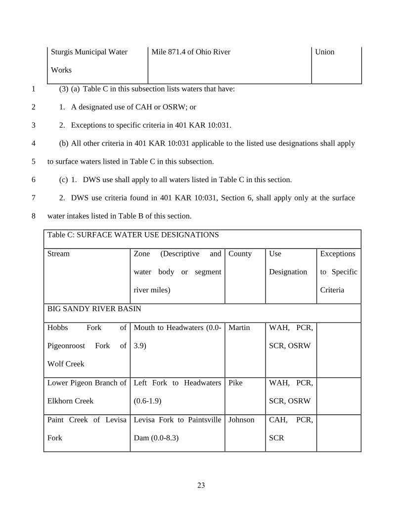
23
Sturgis Municipal Water
Works
Mile 871.4 of Ohio River Union
(3) (a) Table C in this subsection lists waters that have: 1
1. A designated use of CAH or OSRW; or 2
2. Exceptions to specific criteria in 401 KAR 10:031. 3
(b) All other criteria in 401 KAR 10:031 applicable to the listed use designations shall apply 4
to surface waters listed in Table C in this subsection. 5
(c) 1. DWS use shall apply to all waters listed in Table C in this section. 6
2. DWS use criteria found in 401 KAR 10:031, Section 6, shall apply only at the surface 7
water intakes listed in Table B of this section. 8
Table C: SURFACE WATER USE DESIGNATIONS
Stream Zone (Descriptive and
water body or segment
river miles)
County Use
Designation
Exceptions
to Specific
Criteria
BIG SANDY RIVER BASIN
Hobbs Fork of
Pigeonroost Fork of
Wolf Creek
Mouth to Headwaters (0.0-
3.9)
Martin WAH, PCR,
SCR, OSRW
Lower Pigeon Branch of
Elkhorn Creek
Left Fork to Headwaters
(0.6-1.9)
Pike WAH, PCR,
SCR, OSRW
Paint Creek of Levisa
Fork
Levisa Fork to Paintsville
Dam (0.0-8.3)
Johnson CAH, PCR,
SCR

24
Russell Fork of Levisa
Fork of Big Sandy River
Clinch Field RR Yard off
HWY 80 to Virginia State
Line (15.0-16.5)
Pike WAH, PCR,
SCR, OSRW
Thompson Fork of
Souders Branch
Mouth to Headwaters (0.0-
1.0)
Floyd WAH, PCR,
SCR, OSRW
Toms Branch of Elkhorn
Creek
Mouth to Headwaters (0.0-
1.6)
Pike WAH, PCR,
SCR, OSRW
Unidentified Tributary
of Hobbs Fork
Hobbs Fork of Pigeonroost
Fork to Headwaters (0.0-
0.55)
Martin WAH, PCR,
SCR, OSRW
Unidentified Tributary
of Open Fork Paint
Creek
Mouth to Headwaters (0.0-
0.8)
Morgan WAH, PCR,
SCR, OSRW
LAKES AND RESERVOIRS
Paintsville Entire reservoir Johnson WAH, CAH,
PCR, SCR
LITTLE SANDY RIVER BASIN
Arabs Fork of Big
Sinking Creek
Clay Fork to Headwaters
(0.0-5.1)
Elliott WAH, PCR,
SCR, OSRW
Big Caney Creek Grayson Lake to source
(1.8-15.3)
Elliott/
Rowan
CAH, PCR,
SCR, OSRW
25
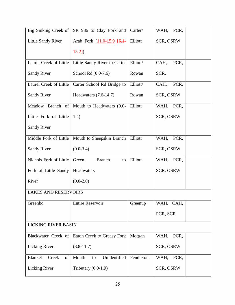
Big Sinking Creek of
Little Sandy River
SR 986 to Clay Fork and
Arab Fork (11.0-15.9 [6.1-
15.2])
Carter/
Elliott
WAH, PCR,
SCR, OSRW
Laurel Creek of Little
Sandy River
Little Sandy River to Carter
School Rd (0.0-7.6)
Elliott/
Rowan
CAH, PCR,
SCR,
Laurel Creek of Little
Sandy River
Carter School Rd Bridge to
Headwaters (7.6-14.7)
Elliott/
Rowan
CAH, PCR,
SCR, OSRW
Meadow Branch of
Little Fork of Little
Sandy River
Mouth to Headwaters (0.0-
1.4)
Elliott WAH, PCR,
SCR, OSRW
Middle Fork of Little
Sandy River
Mouth to Sheepskin Branch
(0.0-3.4)
Elliott WAH, PCR,
SCR, OSRW
Nichols Fork of Little
Fork of Little Sandy
River
Green Branch to
Headwaters
(0.0-2.0)
Elliott WAH, PCR,
SCR, OSRW
LAKES AND RESERVOIRS
Greenbo Entire Reservoir Greenup WAH, CAH,
PCR, SCR
LICKING RIVER BASIN
Blackwater Creek of
Licking River
Eaton Creek to Greasy Fork
(3.8-11.7)
Morgan WAH, PCR,
SCR, OSRW
Blanket Creek of
Licking River
Mouth to Unidentified
Tributary (0.0-1.9)
Pendleton WAH, PCR,
SCR, OSRW

26
Botts Fork of Brushy
Fork of Licking River
Mouth to Landuse Change
(0.0-2.1)
Menifee WAH, PCR,
SCR, OSRW
Bowman Creek Mouth to Unidentified
Tributary (0.0-6.0)
Kenton WAH, PCR,
SCR, OSRW
Brushy Fork of
Meyers Creek
Cave Run Lake Backwaters
to Headwaters (0.7-5.6)
Menifee WAH, PCR,
SCR, OSRW
Bucket Branch of
North Fork of Licking
River
Mouth to Headwaters (0.0-
1.9)
Morgan WAH, PCR,
SCR, OSRW
Cedar Creek of
Licking River
Mouth to North Branch of
Cedar Creek (0.0-1.7)
Robertson WAH, PCR,
SCR, OSRW
Craney Creek Source to North Fork of
Licking River (0.0-11.2)
Rowan/
Morgan
CAH, PCR,
SCR, OSRW
Devils Fork of North
Fork of Licking River
Mouth to Headwaters (0.0-
8.5)
Elliott/
Morgan
WAH, PCR,
SCR, OSRW
Flour Creek of
Licking River
Mouth to Unidentified
Tributary (0.0-2.2)
Pendleton WAH, PCR,
SCR, OSRW
Grovers Creek of
Kincaid Creek
Kincaid Lake Backwaters to
Unidentified Tributary (0.5-
3.4)
Bracken/
Pendleton
WAH, PCR,
SCR, OSRW

27
Licking River River Mile 175.6 (U.S.
Highway 60 Bridge) to
River Mile 180.8 (Cave Run
Lake Dam (175.6-180.8)
Bath/
Rowan
CAH, PCR,
SCR
Licking River River Mile 159.3 [159.5]
(SR [Hwy] 211) to River
Mile 170.5 [170.6]
(Unnamed Road off Slate
[Slatey] Point Road)
Bath/
Rowan/
Fleming
WAH, PCR,
SCR, OSRW
Licking River
River Mile 19.3 (Hwy 536
Bridge) to River Mile 117.6
(1.3 river miles above
Fishtrap Creek)
Kenton/
Campbell/
Pendleton/
Harrison/
Robertson/
Fleming
WAH, PCR,
SCR, OSRW
Minor Creek of
Craney Creek
Mouth to river mile 2.8
(0.0-2.8)
Morgan/
Rowan
CAH, PCR,
SCR
North Fork of Licking
River
Cave Run Lake Backwaters
to Devils Fork (8.4-13.4)
Morgan WAH, PCR,
SCR, OSRW
Sawyers Fork of
Cruises Creek
Mouth to Headwaters (0.0-
3.3)
Kenton WAH, PCR,
SCR, OSRW

28
Slabcamp Creek of
Craney Creek of
Licking River
Mouth to Headwaters (0.0-
3.7)
Rowan CAH, PCR,
SCR, OSRW
Slate Creek of
Licking River
Mouth to Mill Creek (0.0-
13.55)
Bath WAH, PCR,
SCR, OSRW
South Fork Grassy
Creek of Grassy
Creek of Licking
River
Mouth to Greasy Creek
(0.0-19.8)
Kenton/
Pendleton
WAH, PCR,
SCR, OSRW
Unidentified
Tributary of Shannon
Creek of North Fork
of Licking River
Mouth to Headwaters 0.0-
2.2)
Mason WAH, PCR,
SCR, OSRW
Welch Fork of
Brushy Fork of
Licking River
Mouth to First Unnamed
Tributary (0.0-1.0)
Menifee WAH, PCR,
SCR, OSRW
West Creek of
Licking River
Mouth to Headwaters (0.0-
9.8)
Harrison/
Robertson
WAH, PCR,
SCR, OSRW
KENTUCKY RIVER BASIN
Backbone Creek of
Sixmile Creek of
Kentucky River
Mouth to Scrabble Creek
(0.0-1.65)
Franklin/
Henry/
Shelby
WAH, PCR,
SCR, OSRW

29
Bear Branch of North
Fork of Kentucky
River
Above Sediment Pond to
Headwaters (0.3-1.2)
Perry WAH, PCR,
SCR, OSRW
Big Double Creek of
Red Bird River
Mouth to Confluence of
Left and Right Forks of Big
Double Creek (0.0-4.4)
Clay WAH, PCR,
SCR, OSRW
Bill Branch of Laurel
Fork of Greasy Creek
Mouth to Right Fork and
Left Fork Creek (0.0-0.3)
Leslie WAH, PCR,
SCR, OSRW
Billey Fork of Millers
Creek
Land Use Change to
Headwaters (2.6-8.8)
Lee/Elliott WAH, PCR,
SCR, OSRW
Bill Oak Branch of
Left Fork of Buffalo
Creek
Mouth to Headwaters (0.0-
0.3)
Owsley WAH, PCR,
SCR, OSRW
Buffalo Creek of
South Fork of
Kentucky River
Mouth to Right Fork and
Left Fork (0.0-1.6)
Owsley WAH, PCR,
SCR, OSRW
Bullskin Creek of
South Fork Kentucky
River
Mouth to Headwaters (0.0-
14.55)
Clay WAH, PCR,
SCR, OSRW
Cavanaugh Creek South Fork of Station Camp
Creek to Foxtown Rd (0.0-
8.3)
Jackson WAH, PCR,
SCR, OSRW

30
Cherry Run of Boyd
Run of North Elkhorn
Creek
Mouth to Boyd Run (0.0-
0.9)
Scott WAH, PCR,
SCR, OSRW
Chester Creek of
Middle Fork of Red
River
Mouth to Headwaters (0.0-
2.8)
Wolfe WAH, PCR,
SCR, OSRW
Chimney Top Creek
of Red River
Basin (0.0-4.6) Wolfe CAH, PCR,
SCR
Clear Creek of
Kentucky River
Mouth to East Fork Clear
Creek (0.0-9.0)
Woodford WAH, PCR,
SCR, OSRW
Clemons Fork of
Buckhorn Creek
Mouth to Headwaters (0.0-
4.8)
Breathitt WAH, PCR,
SCR, OSRW
Coles Fork of
Buckhorn Creek
Mouth to Headwaters (0.0-
6.2)
Breathitt WAH, PCR,
SCR, OSRW
Craig Creek of
Kentucky River
Mouth (Kentucky River
Backwaters) to Unidentified
Tributary (0.0- 2.7)
Woodford WAH, PCR,
SCR, OSRW
Deep Ford Branch of
Cutshin Creek
Above Pond to Headwaters
(0.3-1.35)
Leslie WAH, PCR,
SCR, OSRW
Dix River Mouth (Kentucky River) to
River Mile 3.1 (Herrington
Lake Dam) (0.0-3.1)
Garrard/
Mercer
CAH, PCR,
SCR

31
Dog Fork of Swift
Camp Creek
Basin Wolfe CAH, PCR,
SCR
Drennon Creek of
Kentucky River
Fivemile Creek to Town
Branch (8.7-12.2)
Henry WAH, PCR,
SCR, OSRW
East Fork of Indian
Creek of Indian Creek
of Red River
Headwaters East Fork of
Indian Creek to Indian
Creek (0.0-9.0)
Menifee CAH, PCR,
SCR OSRW
Elisha Creek of Red
Bird River
Land Use Change
(Residential) to the
confluence of Right Fork
and Middle Fork Elisha
Creek (0.8-1.8)
Leslie WAH, PCR,
SCR, OSRW
Emily Run of
Drennon Creek
Mouth to Unidentified
Tributary (0.0-4.0)
Henry WAH, PCR,
SCR, OSRW
Evans Fork of Billey
Fork of Millers Creek
Mouth to Headwaters (0.0-
3.0)
Estill WAH, PCR,
SCR, OSRW
Falling Rock Branch
of Clemons Fork of
Buckhorn Creek
Mouth to Headwaters (0.0-
0.7)
Breathitt WAH, PCR,
SCR, OSRW
Gilberts Creek of
Kentucky River
Mouth to Unidentified
Tributary (0.0-2.6)
Anderson WAH, PCR,
SCR, OSRW
Gladie Creek of Red
River
Basin Menifee CAH, PCR,
SCR
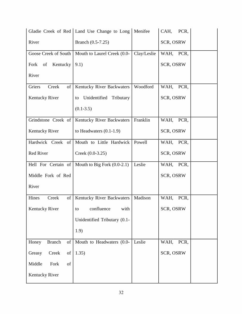
32
Gladie Creek of Red
River
Land Use Change to Long
Branch (0.5-7.25)
Menifee CAH, PCR,
SCR, OSRW
Goose Creek of South
Fork of Kentucky
River
Mouth to Laurel Creek (0.0-
9.1)
Clay/Leslie WAH, PCR,
SCR, OSRW
Griers Creek of
Kentucky River
Kentucky River Backwaters
to Unidentified Tributary
(0.1-3.5)
Woodford WAH, PCR,
SCR, OSRW
Grindstone Creek of
Kentucky River
Kentucky River Backwaters
to Headwaters (0.1-1.9)
Franklin WAH, PCR,
SCR, OSRW
Hardwick Creek of
Red River
Mouth to Little Hardwick
Creek (0.0-3.25)
Powell WAH, PCR,
SCR, OSRW
Hell For Certain of
Middle Fork of Red
River
Mouth to Big Fork (0.0-2.1) Leslie WAH, PCR,
SCR, OSRW
Hines Creek of
Kentucky River
Kentucky River Backwaters
to confluence with
Unidentified Tributary (0.1-
1.9)
Madison WAH, PCR,
SCR, OSRW
Honey Branch of
Greasy Creek of
Middle Fork of
Kentucky River
Mouth to Headwaters (0.0-
1.35)
Leslie WAH, PCR,
SCR, OSRW

33
Hopper Cave Branch
of Cavanaugh Creek
Mouth to Headwaters (0.0-
1.8)
Jackson WAH, PCR,
SCR, OSRW
Indian Creek of Eagle
Creek
Mouth to Headwaters (0.0-
5.4)
Carroll WAH, PCR,
SCR, OSRW
Indian Creek of Red
River
River Mile 1.25 (East Fork
of Indian Creek) to River
Mile 5.2 (0.3 river miles
below Bear Branch)
Menifee CAH, PCR,
SCR
Indian Fork of
Sixmile Creek of
Kentucky River
Mouth to Headwaters (0.0-
3.3)
Shelby WAH, PCR,
SCR, OSRW
Jessamine Creek of
Kentucky River
Stream segment within the
R.J. Corman Natural Area
(12.3-13.55)
Jessamine WAH, PCR,
SCR, OSRW
John Carpenter Fork
of Clemons Fork of
Buckhorn Creek
Mouth to Headwaters (0.0-
1.2)
Breathitt WAH, PCR,
SCR, OSRW
Joyce Fork of
Cortland Fork
Mouth to Headwaters (0.0-
1.2)
Owsley WAH, PCR,
SCR, OSRW
Katies Creek of Red
Bird River
Mouth to Headwaters (0.0-
4.0)
Clay WAH, PCR,
SCR, OSRW

34
Laurel Fork of Left
Fork Buffalo Creek of
Buffalo Creek
Cortland Fork to Big
Branch (0.0-3.75)
Owsley WAH, PCR,
SCR, OSRW
Left Fork of Big
Double Creek of
Kentucky River
Mouth to Headwaters (0.0-
1.5)
Clay WAH, PCR,
SCR, OSRW
Line Fork of North
Fork of Kentucky
River
Defeated Creek to
Headwaters (12.2-28.6)
Letcher WAH, PCR,
SCR, OSRW
Little Middle Fork of
Elisha Creek of Red
Bird River
Mouth to Headwaters (0.0-
0.75)
Leslie WAH, PCR,
SCR, OSRW
Little Millseat Branch
of Clemons Fork of
Buckhorn Creek
Mouth to Headwaters (0.0-
1.2)
Breathitt WAH, PCR,
SCR, OSRW
Little Sixmile Creek
of Sixmile Creek of
Kentucky River
Mouth to Headwaters (0.0-
5.3)
Henry WAH, PCR,
SCR, OSRW
Little Sturgeon Creek
of Sturgeon Creek
Mouth to Warren Chapel
Branch (0.0-3.0)
Owsley WAH, PCR,
SCR, OSRW
Low Gap Branch of
Elk Creek
Mouth to Headwaters (0.0-
0.8)
Letcher WAH, PCR,
SCR, OSRW

35
Lower Devil Creek of
North Fork Kentucky
River
Mouth to Middle Fork
Lower Devil Creek (0.0-
4.65)
Lee WAH, PCR,
SCR, OSRW
Lower Howard Creek
of Kentucky River
Mouth to West Fork (0.5-
6.6)
Clark WAH, PCR,
SCR, OSRW
Lulbegrud Creek of
Red River
Mouth to Falls Branch (0.0-
7.3)
Clark/
Powell
WAH, PCR,
SCR, OSRW
Middle Fork of
Kentucky River
Mouth to Upper Twin Creek
(0.0-12.7)
Lee/
Owsley
WAH, PCR,
SCR, OSRW
Middle Fork of
Kentucky River
Hurts Creek to Greasy
Creek (75.2-85.5)
Leslie WAH, PCR,
SCR, OSRW
Middle Fork of Red
River
River Mile 10.7 (0.7 river
miles below Sinking Fork)
to Headwaters (15.3)
Powell CAH, PCR,
SCR
Middle Fork of Red
River
South Fork of Red River to
Natural Bridge State Park
Lake (1.8-7.2)
Powell CAH, PCR,
SCR, OSRW
Mikes Branch of
Laurel Fork of Left
Fork of Buffalo Creek
Mouth to Headwaters (0.0-
0.7)
Owsley WAH, PCR,
SCR, OSRW
Mill Creek of
Kentucky River
Near Mouth to Headwaters
(0.0-1.85)
Owen WAH, PCR,
SCR, OSRW

36
Millseat Branch of
Clemons Fork of
Buckhorn Creek
Mouth to Headwaters (0.0-
1.85)
Breathitt WAH, PCR,
SCR, OSRW
Muddy Creek of
Kentucky River
Elliston, Kentucky to Viney
Fork (13.8-20.65)
Madison WAH, PCR,
SCR, OSRW
Musselman Creek of
Eagle Creek
Mouth to Headwaters (0.0-
9.0)
Grant WAH, PCR,
SCR, OSRW
Parched Corn Creek Source to Red River (0.0-
2.25)
Wolfe CAH, PCR,
SCR
Red River River Mile 70.4 (SR 746) to
River Mile 50.3 (0.1 Miles
below Auxier Branch)
Menifee/
Wolfe
WAH, PCR,
SCR, OSRW
Red Bird River of
South Fork of
Kentucky River
Mouth to Big Creek (0.0-
15.3)
Clay WAH, PCR,
SCR, OSRW
Right Fork of Buffalo
Creek of Kentucky
River
Mouth to Headwaters (0.0-
2.1)
Owsley WAH, PCR,
SCR, OSRW
Right Fork of Elisha
Creek of Redbird
River
Mouth to Headwaters (0.0-
3.3)
Leslie WAH, PCR,
SCR, OSRW

37
Roaring Fork of
Lewis Fork of
Buckhorn Creek
Mouth to Headwaters (0.0-
0.9)
Breathitt WAH, PCR,
SCR, OSRW
Rock Lick Creek Mouth to Headwaters (0.0-
9.6)
Jackson WAH, PCR,
SCR, OSRW
Sand Ripple Creek of
Kentucky River
Kentucky River Backwaters
to Headwaters (0.1-3.9)
Henry WAH, PCR,
SCR, OSRW
Severn Creek of
Kentucky River
Kentucky River Backwaters
to North Fork of Severn
Creek (1.35-3.0)
Owen WAH, PCR,
SCR, OSRW
Shaker Creek of
Kentucky River
Near Mouth to Shawnee
Run (0.1-1.4)
Mercer WAH, PCR,
SCR, OSRW
Shelly Rock Fork of
Millseat Branch of
Clemons Fork
Mouth to Headwaters (0.0-
0.6)
Breathitt WAH, PCR,
SCR, OSRW
Sixmile Creek of
Kentucky River
Little Sixmile Creek to Dam
(7.1-15.3)
Henry WAH, PCR,
SCR, OSRW
South Fork of
Kentucky River
Mouth to Sexton Creek
(0.0-27.8)
Owsley WAH, PCR,
SCR, OSRW
South Fork of Red
River
Mouth to Sandlick Fork
(0.0-4.2)
Powell WAH, PCR,
SCR, OSRW

38
South Fork of Station
Camp Creek of
Kentucky River
Mouth to Rock Lick Creek
(0.0-9.7)
Jackson WAH, PCR,
SCR, OSRW
Spruce Branch of
Redbird River
Mouth to Headwaters (0.0-
1.0)
Clay WAH, PCR,
SCR, OSRW
Station Camp Creek
of Kentucky River
Landuse Change (Crooked
Cr.) to South Fork of
Station Camp Creek (3.3-
22.7)
Estill WAH, PCR,
SCR, OSRW
Steeles Run of
Elkhorn Creek
Mouth to Unidentified
Tributary (0.0-4.2)
Fayette WAH, PCR,
SCR, OSRW
Steer Fork of War
Fork of Station Camp
Creek
Mouth to Headwaters (0.0-
2.7)
Jackson CAH, PCR,
SCR, OSRW
Sturgeon Creek of
Kentucky River
Duck Fork to Little
Sturgeon Creek (1.3-13.7)
Lee/
Owsley
WAH, PCR,
SCR, OSRW
Sugar Creek of
Redbird River
Landuse Change to
Headwaters (0.6-5.4)
Leslie WAH, PCR,
SCR, OSRW
Sulphur Lick Creek
of Elkhorn Creek
Mouth to Headwaters (0.0-
5.2)
Franklin WAH, PCR,
SCR, OSRW
Swift Camp Creek Red River to Source (0.0-
13.9)
Wolfe CAH, PCR,
SCR

39
Unidentified
Tributary of Cawood
Branch of Beech Fork
Mouth to Headwaters (0.0-
2.1)
Leslie WAH, PCR,
SCR, OSRW
Unidentified
Tributary of Cedar
Creek of Kentucky
River
Mouth to Headwaters (0.0-
1.4)
Owen WAH, PCR,
SCR, OSRW
Unidentified
Tributary of Glenns
Creek of Kentucky
River
Mouth to Headwaters (0.0-
1.9)
Woodford WAH, PCR,
SCR, OSRW
Unidentified
Tributary of Jacks
Creek of Kentucky
River
Mouth to Headwaters (0.0-
1.15)
Madison WAH, PCR,
SCR, OSRW
Unidentified
Tributary of
Kentucky River
Mouth at Kentucky River
Backwaters to Land Use
Change (0.1-1.4)
Franklin WAH, PCR,
SCR, OSRW
Unidentified
Tributary of Line
Fork of North Fork of
Kentucky River
(LCW)
Mouth to Headwaters (0.0-
0.6)
Letcher WAH, PCR,
SCR, OSRW

40
War Fork of Station
Camp Creek
Mouth to Headwaters (0.0-
13.8)
Jackson CAH, PCR,
SCR, OSRW
War Fork of Station
Camp Creek
Basin above River Mile 1.9
(0.3 river miles below
Tarpin Lick Branch (2.5))
Jackson CAH, PCR,
SCR
Watches Fork of
Laurel Fork of Left
Fork of Buffalo Creek
Mouth to Headwaters (0.0-
1.0)
Owsley WAH, PCR,
SCR, OSRW
Wolfpen Creek of
Red River
Mouth to Headwaters (0.0-
3.6)
Menifee WAH, PCR,
SCR, OSRW
LAKES AND RESERVOIRS
Bert Combs Entire Reservoir Clay WAH, CAH,
PCR, SCR
Fishpond Entire Reservoir Letcher WAH, CAH,
PCR, SCR
Mill Creek Entire Reservoir Wolfe WAH, CAH,
PCR, SCR
SALT RIVER BASIN
Brashears Creek of
Salt River
Guist Creek to Bullskin and
Clear Creek (13.0-25.9)
Shelby/
Spencer
WAH, PCR,
SCR, OSRW
Cedar Creek of Salt
River
Mouth to Greens Branch
(0.0-5.2)
Bullitt WAH, PCR,
SCR, OSRW

41
Chaplin River of Salt
River
Thompson Creek to
Cornishville, KY (40.9-
54.2)
Washingto
n
WAH, PCR,
SCR, OSRW
Doctors Fork of
Chaplin River
Mouth to Begley Branch
(0.0-3.8)
Boyle WAH, PCR,
SCR, OSRW
Guist Creek of
Brashears Creek
Mouth to Jeptha Creek (0.0-
15.7)
Spencer WAH, PCR,
SCR, OSRW
Harts Run of Wilson
Creek of Rolling Fork
of Salt River
Mouth to Headwaters (0.0-
1.8)
Bullitt WAH, PCR,
SCR, OSRW
Indian Creek of
Thompson Creek of
Chaplin River of Salt
River
Mouth to Unidentified
Tributary (0.0-2.9)
Mercer WAH, PCR,
SCR, OSRW
Lick Creek of Long
Lick Creek of Beech
Fork of Salt River
Mouth to 0.1miles below
Dam (0.0-4.1)
Washingto
n
WAH, PCR,
SCR, OSRW
Otter Creek of
Rolling Fork of Salt
River
Landuse Change to
confluence of East Fork and
Middle Fork Otter Creek
(1.7-2.9)
Larue WAH, PCR,
SCR, OSRW

42
Overalls Creek of
Wilson Creek of
Rolling Fork of Salt
River
Mouth to Headwaters of
Middle Fork of Overalls
Creek (0.0-3.2)
Bullitt WAH, PCR,
SCR, OSRW
Paddy’s Run Mouth (Ohio River) to
headwaters
Jefferson PCR, SCR 401 KAR
10:031,
Section
2(1)(d) and
2(2) do not
apply.
Rolling Fork of Salt
River
River Mile 53.6 (0.8 mi
upstream of Stiles Rd
Bridge) to River Mile 62.5
(0.5 mi upstream of Otter
Cr)
Larue/
Nelson
WAH, PCR,
SCR, OSRW
Salt Lick Creek of
Rolling Fork of Salt
River
Mouth to Headwaters (0.0-
8.6)
Larue,
Marion
WAH, PCR,
SCR, OSRW
Sulphur Creek of
Chaplin River
Mouth to confluence of
Cheese Lick and Brush
Creek (0.0-10.0)
Anderson/
Mercer/
Washingto
n
WAH, PCR,
SCR, OSRW

43
Unidentified
Tributary of Glens
Creek of Chaplin
River
Mouth to Headwaters (0.0-
2.3)
Washingto
n
WAH, PCR,
SCR, OSRW
West Fork of Otter
Creek of Rolling Fork
of Salt River
Mouth to Headwaters (0.0-
5.4 [5.1])
Larue WAH, PCR,
SCR, OSRW
Wilson Creek of
Rolling Fork of Salt
River
Mouth to Headwaters (0.0-
18.4)
Bullitt/
Nelson
WAH, PCR,
SCR, OSRW
GREEN RIVER BASIN
Barren River Green River to River Mile
Lock and Dam #1 to Green
River (0.0-15.1)
Butler/
Warren
WAH, PCR,
SCR, OSRW
Beaverdam Creek Source to Green River
(14.5-0.0)
Edmonson CAH, PCR,
SCR, OSRW
Big Brush Creek Brush Creek to Poplar
Grove Branch (13.0-17.3)
Green WAH, PCR,
SCR, OSRW
Cane Run of Nolin
River
Nolin River Lake
Backwaters to Headwaters
(0.8-6.5)
Hart WAH, PCR,
SCR, OSRW
Caney Fork of Peter
Creek
Mouth to Headwaters (0.0-
6.7)
Barren WAH, PCR,
SCR, OSRW

44
Clifty Creek of
Rough River
Barton Run to Western
Kentucky Parkway (7.5-
17.3)
Grayson WAH, PCR,
SCR, OSRW
Clifty Creek of Wolf
Lick Creek
Little Clifty Creek to
Sulphur Lick 0.0-13.4)
Todd WAH, PCR,
SCR, OSRW
Double Sink Spring Basin Outside Mammoth
Cave National Park
Boundary
Edmonson/
Barren
CAH, PCR,
SCR, OSRW
East Fork of Little
Barren River
Red Lick Creek to Flat
Creek (18.9-20.6)
Metcalfe WAH, PCR,
SCR, OSRW
Echo River Basin Outside Mammoth
Cave National Park
Boundary (underground
system)
Edmonson CAH, PCR,
SCR, OSRW
Elk Lick Creek 0.1 Mile Downstream of
Mouth of Duck Lick Creek
to Barren Fork Creek and
Edger Creek (3.6-11.8)
Logan WAH, PCR,
SCR, OSRW
Ellis Fork of Damron
Creek
Mouth to Headwaters (0.0-
2.2)
Adair/
Russell
WAH, PCR,
SCR, OSRW
Falling Timber Creek
of Skaggs Creek
Landuse Change to
Headwaters (10.8-15.2)
Barren/
Metcalfe
WAH, PCR,
SCR, OSRW

45
Fiddlers Creek of
North Fork of Rough
River
Mouth to Headwaters (0.0-
5.9)
Breckinrid
ge
WAH, PCR,
SCR, OSRW
Forbes Creek of Buck
Creek of East Fork of
Pond River
Mouth to Unidentified
Tributary (0.0-4.1)
Christian WAH, PCR,
SCR, OSRW
Ganter Spring Basin Outside Mammoth
Cave National Park
Boundary
Edmonson CAH, PCR,
SCR, OSRW
Gasper River of
Barren River
Clear Fork to Wiggington
Creek (17.2-35.6)
Logan/
Warren
WAH, PCR,
SCR, OSRW
Goose Creek of
Green River
Mouth to Little Goose
Creek (0.0-8.5)
Casey/
Russell
WAH, PCR,
SCR, OSRW
Green River River Mile 210.6 (eastern
Mammoth Cave National
Park Boundary to River
Mile 309.1 (Green River
Lake Dam)
Hart/Taylor
/ Green
WAH, PCR,
SCR, OSRW

46
Green River River Mile 185.0 (western
Mammoth Cave National
Park Boundary) to River
Mile 210.6 (eastern
Mammoth Cave National
Park Boundary)
Edmonson/
Hart
WAH, PCR,
SCR, OSRW
Green River Downstream Mammoth
Cave National Park
Boundary to Lynn Camp
Creek (185.0-250.3)
Edmonson/
Hart
WAH, PCR,
SCR, OSRW
Green River River Mile 148.5 (1.0 river
mile below Lock and Dam
#4) to River Mile 170.0
(Lock and Dam #5)
Butler/
Warren
WAH, PCR,
SCR, OSRW
Halls Creek of Rough
River
Unidentified Tributary to
Headwaters (4.8-9.6)
Ohio WAH, PCR,
SCR, OSRW
Lick Creek of West
Fork of Drakes Creek
Mouth to Headwaters (0.0-
10.2)
Simpson CAH, PCR,
SCR, OSRW
Linders Creek of
Rough River
Mouth to Sutzer Creek (0.0-
7.9)
Hardin WAH, PCR,
SCR, OSRW
Little Beaverdam
Creek of Green River
Mouth to SR 743 (0.0-11.4) Edmonson/
Warren
WAH, PCR,
SCR, OSRW

47
Little Short Creek of
Rough River
Mouth to Headwaters (0.0-
3.1)
Grayson WAH, PCR,
SCR, OSRW
Lynn Camp Creek Green River to Source (0.0-
8.3)
Hart CAH, PCR,
SCR
Lynn Camp Creek of
Green River
Mouth to Lindy Creek (0.0-
8.5)
Hart CAH, PCR,
SCR, OSRW
McFarland Creek of
West Fork of Pond
River
Grays Branch to
Unidentified Tributary (1.5-
5.0)
Christian WAH, PCR,
SCR, OSRW
McCoy Spring Basin Outside Mammoth
Cave National Park
Boundary
Hart CAH, PCR,
SCR, OSRW
Meeting Creek of
Rough River
Little Meeting Creek to
Petty Branch (5.2-14.0)
Grayson/
Hardin
WAH, PCR,
SCR, OSRW
Mile 205.7 Spring Basin Outside Mammoth
Cave National Park
Boundary
Hart CAH, PCR,
SCR, OSRW
Muddy Creek of
Caney Creek of
Rough River
Landuse Change to
Headwaters (13.5-15.5)
Ohio WAH, PCR,
SCR, OSRW
Nolin River River Mile 7.7 (Nolin Lake
Dam) to Green River (0.0-
7.7)
Edmonson CAH,WAH,
PCR, SCR

48
North Fork of Rough
River
Buffalo Creek to Reservoir
Dam (22.1 -26.9)
Breckinrid
ge
WAH, PCR,
SCR, OSRW
Peter Creek of Barren
River
Caney Fork to Dry Fork
(11.6-18.5)
Barren WAH, PCR,
SCR, OSRW
Pike Spring Basin Outside Mammoth
Cave National Park
Boundary
Edmonson CAH, PCR,
SCR, OSRW
Pond Run of Rough
River
Landuse Change to
Headwaters (1.4-6.8)
Breckinrid
ge/Ohio
WAH, PCR,
SCR, OSRW
Puncheon Creek Mouth to state line Allen WAH, PCR,
SCR, OSRW
Rough River Linders Creek to Vertrees
Creek (138.0-149.4
Hardin WAH, PCR,
SCR, OSRW
Rough River River Mile 89.6 to Rough
River Lake Dam to 90.4
Ohio/
Grayson
CAH,WAH,
PCR, SCR
Rough River River Mile 74.5 to River
Mile 74.2 (Hwy 54 Bridge)
McLean/
Ohio
CAH, PCR,
SCR
Roundstone Creek of
Nolin River
Hwy 1140 (River Mile 3.8)
to Headwaters (River Mile
10.25)
Hart CAH, PCR,
SCR
Running Spring Basin Outside Mammoth
Cave National Park
Boundary
Edmonson CAH, PCR,
SCR, OSRW

49
Russell Creek of
Green River
Mouth to Columbia WWTP
(0.0-40.0)
Green/
Adair
WAH, PCR,
SCR, OSRW
Russell Creek of
Green River
Reynolds Creek to
confluence with Hudson
Creek and Mount Olive
Creek (56.9 -66.3)
Adair,
Russell
WAH, PCR,
SCR, OSRW
Sixes Creek of Indian
Camp Creek
Wild Branch to Headwaters
(2.0-7.5)
Ohio WAH, PCR,
SCR, OSRW
Suds Spring Basin Outside Mammoth
Cave National Park
Boundary
Hart/
Barren
CAH, PCR,
SCR, OSRW
Sulphur Branch of
Alexander Creek
Mouth to Headwaters (0.0-
3.0)
Edmonson WAH, PCR,
SCR, OSRW
Thompson Branch Webb Branch to Tennessee
State Line (0.3-1.5)
Simpson WAH, PCR,
SCR, OSRW
Trammel Fork of
West Fork of Drakes
Creek
River Mile 30.6
(Kentucky/Tennessee State
Line) to Hwy 31E (River
Mile 23.8 )
Allen CAH, PCR,
SCR,
Trammel Fork of
West Fork of Drakes
Creek
Mouth to Tennessee State
Line (0.0-30.6)
Allen/
Warren
CAH, PCR,
SCR, OSRW

50
Turnhole Spring Basin Outside Mammoth
Cave National Park
Boundary
Edmonson/
Barren
CAH, PCR,
SCR, OSRW
Underground River
System
Mammoth Cave National
Park
Edmonson/
Hart/Barre
n
CAH, PCR,
SCR, OSRW
Unidentified
Tributary of Green
River
Landuse Change to
Headwaters (1.7-3.2)
Adair WAH, PCR,
SCR, OSRW
Unidentified
Tributary of White
Oak Creek
Hovious Rd Crossing to SR
76 (0.0-2.1)
Adair WAH, PCR,
SCR, OSRW
West Fork of Pond
River
Unidentified Tributary to
East Branch of Pond River
(12.45 -22.5)
Christian WAH, PCR,
SCR, OSRW
TRADEWATER RIVER BASIN
East Fork of Flynn
Fork of Tradewater
River
Landuse Change (US Hwy
62) to Headwaters (2.15-
4.6)
Caldwell WAH, PCR,
SCR, OSRW
Piney Creek of
Tradewater River
Lake Beshear Backwaters to
Headwaters (4.5-10.2)
Caldwell,
Christian
WAH, PCR,
SCR, OSRW
Sandlick Creek of
Tradewater River
Camp Creek to Headwaters
(4.5-8.6)
Christian WAH, PCR,
SCR, OSRW

51
Tradewater River Dripping Springs Branch to
Buntin Lake Dam (126.2-
133.9)
Christian WAH, PCR,
SCR, OSRW
Unidentified
Tributary of Piney
Creek of Tradewater
River
Mouth to Headwaters (0.0-
2.9)
Caldwell WAH, PCR,
SCR, OSRW
Unidentified
Tributary of Sandlick
Creek of Tradewater
River
Mouth to Headwaters (0.0-
1.4)
Christian WAH, PCR,
SCR, OSRW
LOWER CUMBERLAND RIVER BASIN
Casey Creek Mouth to headwaters (0.0-
10.5)
Trigg CAH, PCR,
SCR
Crooked Creek of
Cumberland River
Energy Lake Backwaters to
Headwaters (3.0-9.1)
Trigg WAH, PCR,
SCR, OSRW
Cumberland River 0.2 Mile Downstream of
Hickory Creek to 0.6 mile
Upstream of Sugar Creek
(10.2-11.9)
Livingston WAH, PCR,
SCR, OSRW
Donaldson Creek of
Cumberland River
Barkley Lake Backwaters to
Unnamed Tributary (4.0-
7.2)
Trigg WAH, PCR,
SCR, OSRW

52
Elk Fork of Red
River of Cumberland
River
Tennessee State Line to Dry
Branch (7.5-23.1)
Todd WAH, PCR,
SCR, OSRW
Skinframe Creek Livingston Creek to
Headwaters (0.0-7.8)
Lyon CAH, PCR,
SCR
Sugar Creek of
Cumberland River
Lick Creek to Unidentified
Tributary (2.2-6.9)
Livingston WAH, PCR,
SCR, OSRW
Sulphur Spring Creek Red River to Headwaters
(0.0-9.1)
Simpson CAH, PCR,
SCR
West Fork of Red
River
State Line to River Mile
32.2 (14.75-32.2) [29.0
(14.5-32.2)]
Christian CAH, PCR,
SCR, OSRW
Whipporwill Creek Red River to Headwaters
(0.0-45.4)
Logan/Tod
d
WAH, PCR,
SCR, OSRW
UPPER CUMBERLAND RIVER BASIN
Acorn Fork of
Stinking Creek
Basin above River Mile 1.0 Knox WAH, PCR,
SCR, OSRW
Adams Branch of
Pigeon Roost Creek
Basin Whitley WAH, PCR,
SCR, OSRW
Archers Creek of
Cumberland River
Basin (above RM 0.05 mi
backwater at mouth)
Whitley WAH, PCR,
SCR, OSRW

53
Bad Branch of Poor
Fork of Cumberland
River
Basin Letcher CAH, PCR,
SCR, OSRW
Bark Camp Creek of
Cumberland River
Basin (above RM 0.1
backwater at mouth)
Whitley CAH, PCR,
SCR, OSRW
Barren Fork of Indian
Creek
Basin McCreary WAH, PCR,
SCR, OSRW
Beaver Creek of
Cumberland River
Basin McCreary CAH, PCR,
SCR, OSRW
Bee Lick Creek of
Brushy Creek of
Buck Creek
Mouth to Warren Branch
(0.0-5.7)
Pulaski WAH, PCR,
SCR, OSRW
Bens Fork of Little
Clear Creek
Basin Bell WAH, PCR,
SCR, OSRW
Big Branch of Marsh
Creek
Basin above River Mile 0.8 McCreary WAH, PCR,
SCR, OSRW
Big Lick Branch of
Cumberland River
Basin (above 1.1,
Cumberland River
backwaters)
Pulaski WAH, PCR,
SCR, OSRW
Blacksnake Branch of
Brownies Creek
Basin Bell WAH, PCR,
SCR, OSRW

54
Breedens Creek of
Clover Fork of
Cumberland River
Basin Harlan WAH, PCR,
SCR, OSRW
Brices Creek of Road
Fork of Stinking
Creek
Basin Knox WAH, PCR,
SCR, OSRW
Brownies Creek of
Cumberland River
Basin above Blacksnake
Branch (RM 10.3)
Harlan WAH, PCR,
SCR, OSRW
Brush Creek of
Roundstone Creek
Wolf Creek to Reemergence
of Sinking Creek (1.1-7.6)
Rockcastle WAH, PCR,
SCR, OSRW
Brushy Creek of
Buck Creek
Mouth to Headwaters (0.0-
16.5)
Pulaski WAH, PCR,
SCR, OSRW
Buck Creek of
Cumberland River
River Mile 11.7
(Backwaters of Lake
Cumberland) to RM 55.0
(0.8 RM upstream of
confluence of Hurricane
Creek)
Pulaski WAH, PCR,
SCR, OSRW
Buck Creek of Clear
Fork of Cumberland
River
Basin Whitley WAH, PCR,
SCR, OSRW
Bucks Branch of
Jellico Creek
Basin Whitley WAH, PCR,
SCR, OSRW

55
Buffalo Creek of
Laurel Fork of Clear
Fork of Cumberland
River
Basin above Kentucky/
Tennessee State Line
Whitley WAH, PCR,
SCR, OSRW
Bunches Creek of
Cumberland River
Basin Whitley CAH, PCR,
SCR, OSRW
Campbell Branch of
Jellico Creek
Basin Whitley WAH, PCR,
SCR, OSRW
Cane Creek of
Rockcastle River
Mouth to Dam (0.0-11.85) Laurel WAH, PCR,
SCR, OSRW
Caney Creek of Left
Fork of Straight
Creek
Basin Bell WAH, PCR,
SCR, OSRW
Cannon Creek of
Yellow Creek
Basin above Cannon Creek
Lake (RM 5.1)
Bell WAH, PCR,
SCR, OSRW
Capuchin Creek of
Jellico Creek
Basin from Mouth to
Kentucky/Tennessee State
Line (0.0-1.25)
McCreary WAH, PCR,
SCR, OSRW
Clear Creek of
Roundstone Creek
Scaffold Cane Branch to
Davis Branch (3.45-7.8)
Rockcastle WAH, PCR,
SCR, OSRW
Clifty Creek of
Brushy Creek of
Buck Creek
Mouth to Rocky Branch
(0.0-2.7)
Pulaski WAH, PCR,
SCR, OSRW
56
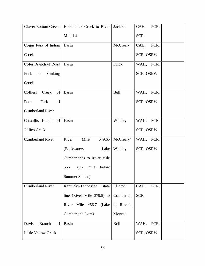
Clover Bottom Creek Horse Lick Creek to River
Mile 1.4
Jackson CAH, PCR,
SCR
Cogur Fork of Indian
Creek
Basin McCreary CAH, PCR,
SCR, OSRW
Coles Branch of Road
Fork of Stinking
Creek
Basin Knox WAH, PCR,
SCR, OSRW
Colliers Creek of
Poor Fork of
Cumberland River
Basin Bell WAH, PCR,
SCR, OSRW
Criscillis Branch of
Jellico Creek
Basin Whitley WAH, PCR,
SCR, OSRW
Cumberland River River Mile 549.65
(Backwaters Lake
Cumberland) to River Mile
566.1 (0.2 mile below
Summer Shoals)
McCreary/
Whitley
WAH, PCR,
SCR, OSRW
Cumberland River Kentucky/Tennessee state
line (River Mile 379.8) to
River Mile 456.7 (Lake
Cumberland Dam)
Clinton,
Cumberlan
d, Russell,
Monroe
CAH, PCR,
SCR
Davis Branch of
Little Yellow Creek
Basin Bell WAH, PCR,
SCR, OSRW

57
Dog Slaughter Creek
of Cumberland River
Basin Whitley CAH, PCR,
SCR, OSRW
Dolen Branch of
Rock Creek
Basin McCreary WAH, PCR,
SCR, OSRW
Eagle Creek of
Cumberland River
Basin McCreary WAH, PCR,
SCR, OSRW
Elisha Branch of
Laurel Creek
Basin McCreary WAH, PCR,
SCR, OSRW
FishTrap Branch Basin above River Mile 0.5
(Lake Cumberland
backwaters)
McCreary WAH, PCR,
SCR, OSRW
Four Mile Creek of
Cumberland River
Basin above River Mile 2.5 Bell WAH, PCR,
SCR, OSRW
Four Mile Run of
Yellow Creek Bypass
Basin above River Mile 1.0 Bell WAH, PCR,
SCR, OSRW
Fugitt Creek of
Clover Fork of
Cumberland River
Basin Harlan CAH, PCR,
SCR, OSRW
Hale Fork of Road
Fork of Stinking
Creek
Basin Knox WAH, PCR,
SCR, OSRW
Hawk Creek of
Rockcastle River
Basin Laurel CAH, PCR,
SCR

58
Hinkle Branch of
Road Fork of
Stinking Creek
Basin Knox WAH, PCR,
SCR, OSRW
Honeycutt Branch of
Turkey Creek of
Stinking Creek
Basin Knox WAH, PCR,
SCR, OSRW
Horse Lick Creek Mouth (0.0) at Middle Fork
of Rockcastle River to River
Mile 12.3 (Clover Bottom
Creek)
Jackson/
Rockcastle
WAH, PCR,
SCR, OSRW
Howards Creek of
Illwill Creek of Wolf
River
Dale Hollow Reservoir
Backwaters to Headwaters
Clinton WAH, PCR,
SCR, OSRW
Hunting Shirt Branch
of Richland Creek
Basin Knox WAH, PCR,
SCR, OSRW
Indian Creek of
Cumberland River
Kilburn Fork to Barren Fork
(2.4-6.8)
McCreary WAH, PCR,
SCR, OSRW
Indian Creek of
Cumberland River
Basin above and including
Barren Fork
McCreary CAH, PCR,
SCR, OSRW
Jackie Branch of Bark
Camp Creek
Mouth to Headwaters (0.0-
1.65)
Whitley CAH, PCR,
SCR, OSRW

59
Jellico Creek of
Cumberland River
River Mile 22.5 (confluence
with Capuchin Creek) to
River Mile 25.25 [25.3]
(Kentucky/Tennessee State
Line)
McCreary WAH, PCR,
SCR, OSRW
Jellico Creek of
Cumberland River
Basin From and Including
Capuchin Creek to the
Kentucky/Tennessee State
Line (22.5 to 25.25)
McCreary WAH, PCR,
SCR, OSRW
Jennys Branch of
Laurel Creek [Fork]
of Marsh Creek
Basin McCreary WAH, PCR,
SCR, OSRW
Kelly Branch of
Clover Fork of
Cumberland River
Basin Harlan WAH, PCR,
SCR, OSRW
Kennedy Creek of
Little South Fork of
Cumberland River
Little South Fork of
Cumberland River to River
Mile 1.0
Wayne WAH, PCR,
SCR, OSRW
Kettle Creek Kentucky/Tennessee State
Line to Wells Creek (1.75-
6.1)
Monroe WAH, PCR,
SCR, OSRW

60
Kilburn Fork of
Indian Creek
Basin McCreary WAH, PCR,
SCR,
OSRW
Laurel Creek of
Marsh Creek
River Mile 3.1 (Jennys
Branch) to River Mile 9.0
(Dam)
McCreary CAH, PCR,
SCR, OSRW
Laurel Creek of
Marsh Creek
Basin above Mouth of
Jennys Branch to Laurel
Creek Lake Dam (3.2-9.0)
McCreary WAH, CAH,
PCR, SCR,
OSRW
Laurel Fork of Clear
Fork of Cumberland
River
Basin above River Mile
16.0 (John Partin Road off
Hwy 190)
Bell WAH, PCR,
SCR, OSRW
Laurel Fork of Clear
Fork of Cumberland
River
River Mile 4.3 [4.25]
(Kentucky/Tennessee state
line) to River Mile 16.0
(John Partin Road off Hwy
90)
Whitley WAH, PCR,
SCR, OSRW
Laurel Fork of
Kilburn Fork
Basin McCreary WAH, PCR,
SCR, OSRW
Laurel Fork of
Middle Fork
Rockcastle River
Middle Fork of Rockcastle
River to Headwaters (0.0-
12.3)
Jackson WAH, PCR,
SCR, OSRW

61
Laurel River River Mile 0.9 to Laurel
River Lake Dam (0.9-2.4)
Laurel,
Whitley
CAH, PCR,
SCR
Lick Fork of Yellow
Creek By-Pass of
Yellow Creek
Basin Bell WAH, PCR,
SCR, OSRW
Little Popular
Creek of Cumberland
River
Basin above Hubbs Creek
(4.4)
Knox WAH, PCR,
SCR, OSRW
Little South Fork of
Cumberland River
River Mile 4.4 (backwaters
of Lake Cumberland) to
River Mile 35.5
(Confluence with Langham
Branch)
Wayne,
McCreary
WAH, PCR,
SCR, OSRW
Little White Oak
Creek
Mouth to Headwaters (0.0-
2.6)
Laurel WAH, PCR,
SCR, OSRW
Long Branch of Left
Fork of Straight
Creek
Basin Bell WAH, PCR,
SCR, OSRW
Looney Creek of Poor
Fork of Cumberland
River
Basin above River Mile 5.9
(Lynch City Limits)
Harlan CAH, PCR,
SCR

62
Marsh Creek Basin above River Mile
24.6 (Confluence with
Murphy Creek) to River
Mile 26.5 (within
Kentucky)
McCreary WAH, PCR,
SCR, OSRW
Marsh Creek River Mile 0.05 (confluence
with Cumberland River) to
River Mile 24.6 (confluence
with Murphy Creek)
McCreary WAH, PCR,
SCR, OSRW
Martins Fork Basin above River Mile
32.7 (Cumberland Gap
National Historical Park
Boundary)
Bell CAH, PCR,
SCR
Martins Fork River Mile 27.2 to River
Mile 32.7 (Cumberland Gap
National Historical Park
Boundary)
Bell,
Harlan
CAH, PCR,
SCR, OSRW
McFarland Creek of
Cumberland River
Little McFarland Creek to
Spring Branch (0.8-6.2)
Monroe WAH, PCR,
SCR, OSRW
Meadow Branch of
Poor Fork
Cumberland River
Mouth to River Mile 1.95
and Basin above the East-
Southeast Unnamed
Tributary
Harlan WAH, PCR,
SCR, OSRW

63
Meadow Fork of
Franks Creek
Basin Letcher WAH, PCR,
SCR, OSRW
Meshack Creek of
Cumberland River
Mouth to Pitcock Branch
(0.0-2.8)
Monroe WAH, PCR,
SCR, OSRW
Middle Fork of
Rockcastle River
Confluence of Middle and
South Forks of Rockcastle
River (River Mile 0.0) to
River Mile 7.9 (confluence
of Indian Creek and Laurel
Fork )
Jackson WAH, PCR,
SCR, OSRW
Mill Branch of
Stinking Creek
Basin above reservoir
backwaters (0.8)
Knox WAH, PCR,
SCR, OSRW
Mill Creek of Straight
Creek
Basin Bell WAH, PCR,
SCR, OSRW
Mill Creek of
Cumberland River
Basin McCreary WAH, PCR,
SCR, OSRW
Moore Creek of
Stinking Creek
Basin Knox WAH, PCR,
SCR, OSRW
Mud Creek of Clear
Fork of Cumberland
River
Basin above River Mile 6.5
(0.3 river miles above Siler
Cemetery Road Bridge)
Whitley WAH, PCR,
SCR, OSRW
Mud Camp Creek of
Cumberland River
Mouth to Collins Branch
(0.0-1.2)
Cumberlan
d
WAH, PCR,
SCR, OSRW

64
Mud Camp Creek of
Cumberland River
Unidentified Tributary to
Headwaters (3.8-8.8)
Cumberlan
d/ Monroe
WAH, PCR,
SCR, OSRW
Mud Lick of Stinking
Creek
Basin Knox WAH, PCR,
SCR, OSRW
Ned Branch of
Rockcastle River
Basin above backwaters
(RM 0.45)
Laurel WAH, PCR,
SCR, OSRW
Otter Creek of
Cumberland River
Lake Cumberland
Backwaters to Carpenter
Fork (14.0-22.1)
Wayne WAH, PCR,
SCR, OSRW
Patterson Creek of
Cumberland River
Basin above River Mile 7.3
(confluence with Rose
Creek)
Whitley WAH, PCR,
SCR, OSRW
Poor Fork of
Cumberland River
Franks Creek to Headwaters
(41.4-51.7)
Letcher WAH, PCR,
SCR, OSRW
Poor Fork of
Cumberland River
Basin above River Mile
48.1 (at Joseph Road off of
Hwy 932)
Letcher CAH, PCR,
SCR, OSRW
Presley House Branch
of Poor Fork of
Cumberland River
Mouth to Headwaters (0.0-
1.5)
Letcher WAH, PCR,
SCR, OSRW

65
Puncheoncamp
Branch of Rock
Creek of South Fork
of Cumberland River
Mouth to Headwaters (0.0-
1.85)
McCreary WAH, PCR,
SCR, OSRW
Richland Creek of
Cumberland River
Basin above River Mile
15.8 (0.5 stream miles
above Hubbard Branch) to
River Mile 21.4
Knox WAH, PCR,
SCR, OSRW
Roaring Fork of
Stinking Creek
Basin Knox WAH, PCR,
SCR, OSRW
Rock Creek of South
Fork of Cumberland
River
Kentucky/Tennessee State
Line (River Mile 21.5) to
White Oak Creek
McCreary CAH, PCR,
SCR, OSRW
Rock Creek of Jellico
Creek
Basin McCreary WAH, PCR,
SCR, OSRW
Rockcastle River River Mile 8.95 (backwaters
of Lake Cumberland) to
River Mile 54.7 (confluence
of Middle Fork and South
Fork Rockcastle River)
Laurel/
Pulaski
WAH, PCR,
SCR, OSRW
Ross Branch of
Jellico Creek
Basin Whitley WAH, PCR,
SCR, OSRW

66
Roundstone Creek of
Rockcastle River
River Mile 13.5 (confluence
of Renfro Creek) to River
Mile 26.4 (Interstate -75)
Rockcastle WAH, PCR,
SCR, OSRW
Ryans Creek of
Jellico Creek
Basin Whitley WAH, PCR,
SCR, OSRW
Sanders Creek of
Cumberland River
Basin Whitley WAH, PCR,
SCR, OSRW
Shillalah Creek of
Clear Fork of Yellow
Creek
Cumberland Gap National
Historical Park Boundary to
Headwaters (1.5-5.5)
Bell CAH, PCR,
SCR, OSRW
Shillalah Creek of
Clear Fork of Yellow
Creek
Mouth to Cumberland Gap
National Historical Park
Boundary (0.0-1.5)
Bell WAH, PCR,
SCR, OSRW
Shut-in Branch of
Jellico Creek
Basin McCreary WAH, PCR,
SCR, OSRW
Sinking Creek Headwaters to Rockcastle
River (0.0-20.3)
Laurel WAH, PCR,
SCR, OSRW
Sims Fork of Left
Fork of Straight
Creek
Basin Bell WAH, PCR,
SCR, OSRW
Smith Creek of
Franks Creek
Basin Letcher WAH, PCR,
SCR, OSRW

67
South Fork of
Cumberland River
River Mile 44.3 (Blue
Heron) to River Mile 54.8
(Kentucky /Tennessee State
Line)
McCreary WAH, PCR,
SCR, OSRW
South Fork of
Rockcastle River
River Mile 2.1 to White
Oak Creek (River Mile 5.8)
Laurel WAH, PCR,
SCR, OSRW
South Fork of
Rockcastle River
Rockcastle River (River
Mile 0.0) to River Mile 2.1
Rockcastle WAH, PCR,
SCR, OSRW
Stevenson Branch of
Bennetts Fork of
Yellow Creek
Basin Bell WAH, PCR,
SCR, OSRW
Sulphur Creek of
Wolf River of Obey
River
Dale Hollow Reservoir
Backwaters to Headwaters
(1.7-5.1)
Clinton WAH, PCR,
SCR, OSRW
Trace Branch of
Stinking Creek
Basin Knox WAH, PCR,
SCR, OSRW
Trammel Fork of
Marsh Creek
Basin McCreary WAH, PCR,
SCR, OSRW
Turkey Creek of
Stinking Creek
Basin Knox WAH, PCR,
SCR, OSRW
Tyes Fork of Bennetts
Fork of Patterson
Creek
Basin Whitley WAH, PCR,
SCR, OSRW

68
Unidentified
Tributary of Cane
Creek of Rockcastle
River
Mouth to Headwaters (0.0-
1.2)
Laurel WAH, PCR,
SCR, OSRW
Unidentified
Tributary (across
from Hemlock Grove
at river mile 9.3 of
Rock Creek) of Rock
Creek of South Fork
of Cumberland River
Mouth to Headwaters (0.0-
1.2)
McCreary WAH, PCR,
SCR, OSRW
Unidentified
Tributary (RMI 17.05
[17.0] of Rock Creek)
of Rock Creek of
South Fork of
Cumberland River
Mouth to Headwaters (0.0-
1.9 [1.3])
McCreary WAH, PCR,
SCR, OSRW
Watts Branch of Rock
Creek
Basin McCreary WAH, PCR,
SCR, OSRW
Watts Creek of
Cumberland River
Basin above Camp Blanton
Lake (2.4)
Harlan WAH, PCR,
SCR, OSRW
White Oak Creek of
Rock Creek
Basin McCreary WAH, PCR,
SCR, OSRW

69
White Oak Creek of
Sinking Creek
Basin above River Mile 0.9
(includes Little White Oak
Creek)
Laurel CAH, PCR,
SCR
Wolf Creek of Clear
Fork
Basin above Little Wolf
Creek (2.0-5.9)
Whitley WAH, PCR,
PSCR, OSRW
Wood Creek of Little
Rockcastle River
Confluence with Hazel
Patch Creek (0.0) to River
Mile 1.9 (Wood Creek Lake
Dam)
Laurel CAH, PCR,
SCR
Youngs Creek of
Cumberland River
Basin Whitley WAH, PCR,
SCR, OSRW
LAKES AND RESERVOIRS
Beulah
(=Tyner)
Entire Reservoir Jackson WAH, CAH,
PCR, SCR
Cannon Creek Entire Reservoir Bell WAH, CAH,
PCR, SCR
Laurel River Entire Reservoir Laurel/
Whitley
WAH, CAH,
PCR, SCR
Wood Creek Entire Reservoir Laurel WAH, CAH,
PCR, SCR
TENNESSEE RIVER BASIN

70
Blood River of
Kentucky Lake
(Tennessee River)
McCullough Fork to
Tennessee State Line
(15.15-18.7)
Calloway WAH, PCR,
SCR, OSRW
Clarks River of
Tennessee River
Persimmon Slough to
Middle Fork Creek (28.6-
30.6) [(28.7-30.7)]
Marshall WAH, PCR,
SCR, OSRW
Grindstone Creek of
Kentucky Lake
(Blood River of
Tennessee River)
Kentucky Lake Backwaters
to Headwaters (0.7-2.9)
Calloway WAH, PCR,
SCR, OSRW
Panther Creek of
Kentucky Lake
(Blood River of
Tennessee River)
Kentucky Lake Backwaters
to Headwaters (0.5-5.7)
Calloway WAH, PCR,
SCR, OSRW
Soldier Creek of West
Fork of Clarks River
Mouth to South Fork of
Soldier Creek (0.0-5.7)
Marshall WAH, PCR,
SCR, OSRW
Sugar Creek of
Kentucky Lake
(Tennessee River)
Kentucky Lake Backwaters
to Buzzard Roost Road (2.5-
3.2)
Calloway WAH, PCR,
SCR, OSRW
Sugar Creek of West
Fork Clarks River
Mouth to Unnamed
Reservoir (0.0-3.9)
Graves WAH, PCR,
SCR, OSRW

71
Tennessee River River 12.0 (approximately
0.4 miles above Mud Creek)
to 22.8 (Kentucky Lake
Dam
Livingston/
Marshall
WAH, PCR,
SCR, OSRW
Tennessee River River Mile 23.1 (Kentucky
Lake Dam) to River Mile
12.4 (12.4-23.1)
Livingston/
McCracken
/ Marshall
WAH, PCR,
SCR, OSRW
Trace Creek of West
Fork of Clarks River
Mouth to Neeley Branch
(0.0-3.35)
Graves WAH, PCR,
SCR, OSRW
Unidentified
Tributary of
Unidentified
Tributary of Panther
Creek of West Fork
of Clarks River
Mouth to Headwaters (0.0-
1.7)
Graves WAH, PCR,
SCR, OSRW
West Fork of Clarks
River
Soldier Creek to Duncan
Creek (20.1-23.5)
Graves WAH, PCR,
SCR, OSRW
Wildcat Creek of
Kentucky Lake
(Blood River of
Tennessee River)
Ralph Wright Road
Crossing to Headwaters (3.6
[2.8]-6.8)
Calloway WAH, PCR,
SCR, OSRW
OHIO RIVER BASIN (Main Stem and Minor Tributaries)

72
Ashbys Fork Mouth to Petersburg Road
(SR 20) (0.0-3.7)
Boone WAH, PCR,
SCR, OSRW
Crooked Creek Rush Creek to City Lake
Dam (17.9-26.2)
Crittenden WAH, PCR,
SCR, OSRW
Doe Run Creek Hwy 1638 to Headwaters
(5.2-8.3)
Meade CAH, PCR,
SCR
Double Lick Creek of
Woolper Creek
Mouth to Headwaters (0.0-
3.5)
Boone WAH, PCR,
SCR, OSRW
Garrison Creek Mouth to Headwaters (0.0-
4.85)
Boone WAH, PCR,
SCR, OSRW
Kinniconick Creek McDowell Creek to
Headwaters (5.05-50.9)
Lewis WAH, PCR,
SCR, OSRW
Little South Fork of
Big South Fork
Land Use Change to
Headwaters (1.2-5.9)
Boone WAH, PCR,
SCR, OSRW
Middle Fork of
Massac Creek
Hines Road to Headwaters
(3.1-6.4)
McCracken WAH, PCR,
SCR, OSRW
Ohio River River Mile 848.0 to River
Mile 850.0
Union WAH, PCR,
SCR, OSRW
Ohio River River Mile 856.4-852.0 Union WAH, PCR,
SCR, OSRW
Ohio River River Mile 859.0 to River
Mile 861.0
Union WAH, PCR,
SCR, OSRW

73
Ohio River River Mile 865.0 to River
Mile 867.0
Union WAH, PCR,
SCR, OSRW
Ohio River River Mile 923.5 to River
Mile 926.0
Livingston WAH, PCR,
SCR, OSRW
Ohio River River Mile 927.0 to River
Mile 930.0
Livingston WAH, PCR,
SCR, OSRW
Ohio River River Mile 933.0 to 937.0 McCracken WAH, PCR,
SCR, OSRW
Ohio River River Mile 937.0 [940.7] to
River Mile 939.8 [943.3]
McCracken WAH, PCR,
SCR, OSRW
Ohio River River Mile 948.2 to River
Mile 949.5
McCracken WAH, PCR,
SCR, OSRW
Ohio River River Mile 960.0 to River
Mile 962.7 (above Lock and
Dam 53)
Ballard WAH, PCR,
SCR, OSRW
Ohio River River Mile 966.3 to River
Mile 969.5
Ballard WAH, PCR,
SCR, OSRW
Ohio River River Mile 922.0 to River
Mile 923.5 (Channel East of
Towhead Island)
Livingston WAH, PCR,
SCR, OSRW
Otter Creek Ohio River to River Mile
9.7
Meade CAH, PCR,
SCR

74
Second Creek Ohio River Backwaters to
Headwaters (0.2-2.7)
Boone WAH, PCR,
SCR, OSRW
Sinking Creek Hwy 259 to Headwaters
(includes Blue & Stony
Forks)
Breckinrid
ge
CAH, PCR,
SCR
Unidentified
Tributary of Big
Sugar Creek
I-71 to Headwaters (1.0-3.4)
[(1.0-1.8)]
Gallatin WAH, PCR,
SCR, OSRW
Unidentified
Tributary of Corn
Creek
Mouth to Headwaters (0.0-
2.3)
Trimble WAH, PCR,
SCR, OSRW
Unidentified
Tributary of Massac
Creek
Mouth to Headwaters (0.0-
1.7)
McCracken WAH, PCR,
SCR, OSRW
West Fork of Massac
Creek
SR 724 [725] to Little
Massac Creek (1.0-6.2)
McCracken WAH, PCR,
SCR, OSRW
White Oak Creek Mouth (Ohio River) to
River Mile 1.08
Greenup SCR 401 KAR
10:031,
Section
2(1)(d) and
2(2) do not
apply.
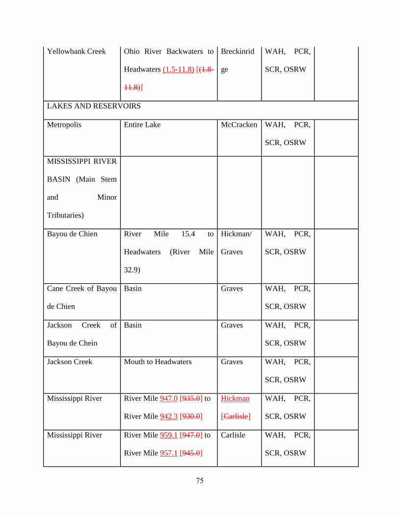
75
Yellowbank Creek Ohio River Backwaters to
Headwaters (1.5-11.8) [(1.8-
11.8)]
Breckinrid
ge
WAH, PCR,
SCR, OSRW
LAKES AND RESERVOIRS
Metropolis Entire Lake McCracken WAH, PCR,
SCR, OSRW
MISSISSIPPI RIVER
BASIN (Main Stem
and Minor
Tributaries)
Bayou de Chien River Mile 15.4 to
Headwaters (River Mile
32.9)
Hickman/
Graves
WAH, PCR,
SCR, OSRW
Cane Creek of Bayou
de Chien
Basin Graves WAH, PCR,
SCR, OSRW
Jackson Creek of
Bayou de Chein
Basin Graves WAH, PCR,
SCR, OSRW
Jackson Creek Mouth to Headwaters Graves WAH, PCR,
SCR, OSRW
Mississippi River River Mile 947.0 [935.0] to
River Mile 942.3 [930.0]
Hickman
[Carlisle]
WAH, PCR,
SCR, OSRW
Mississippi River River Mile 959.1 [947.0] to
River Mile 957.1 [945.0]
Carlisle WAH, PCR,
SCR, OSRW
76
Obion Creek Hurricane Creek to Little
Creek (26.35-36.55)
Hickman WAH, PCR,
SCR, OSRW
Sand Creek of Bayou
de Chein
Basin Graves WAH, PCR,
SCR, OSRW
South Fork of Bayou
de Chien
Basin Graves WAH, PCR,
SCR, OSRW
Terrapin Creek Tennessee State Line to
Headwaters (2.7-6.0)
Graves WAH, PCR,
SCR, OSRW
LAKES AND RESERVOIRS
Murphy’s Pond Entire Pond and Preserve
Area
Hickman WAH, PCR,
SCR, OSRW
Swan Pond Entire Lake Ballard WAH, PCR,
SCR, OSRW
Section 6. Incorporation by Reference. 1
(1) "Interim Economic Guidance for Water Quality Standards Workbook", EPA, March 1995 2
Publication EPA-823-B-95-002. U.S. Environmental Protection Agency, Office of Water, 3
Washington, D.C., is incorporated by reference. 4
(2) This material may be inspected, copied, or obtained, subject to applicable copyright law, 5
at the Kentucky Division of Water, 200 Fair Oaks Lane, Frankfort, Kentucky, Monday through 6
Friday, 8 a.m. to 4:30 p.m. 7

77
401 KAR 10:026 “Designation of uses of surface waters.” approved for promulgation:
Date Leonard K. Peters, Secretary
Energy and Environment Cabinet

78
PUBLIC HEARING AND PUBLIC COMMENT PERIOD: A public hearing on this
administrative regulation shall be held on September 27, 2012 at 5:00 P.M. (Eastern Time) at
300 Fair Oaks Lane, Conference Room 301D, Frankfort, Kentucky.
Individuals interested in being heard at this hearing shall notify this agency in writing by
September 17, 2012, five workdays prior to the hearing, of their intent to attend. If no
notification of intent to attend the hearing is received by that date, the hearing may be canceled.
This hearing is open to the public. Any person who wishes to be heard will be given an
opportunity to comment on the proposed administrative regulation. A transcript of the public
hearing will not be made unless a written request for a transcript is made. If you do not wish to
be heard at the public hearing, you may submit written comments on the proposed administrative
regulation. Written comments shall be accepted until October 1, 2012. Send written notification
of intent to be heard at the public hearing or written comments on the proposed administrative
regulation to the contact person.
CONTACT PERSON: Peter Goodmann
Division of Water
200 Fair Oaks Lane
Frankfort, KY 40601
Telephone: (502) 564-3410 Fax (502) 564-0111
Email: [email protected]

79
REGULATORY IMPACT ANALYSIS AND TIERING STATEMENT
Administrative Regulation #: 401 KAR 10:026
Contact Person: Sandy Gruzesky, Director
(1) Provide a brief summary of:
(a) What this administrative regulation does: This administrative regulation lists the types of
designated uses for surface waters of the Commonwealth, provides for redesignation of
surface waters, describes the process for redesignation of surface waters, and lists designated
uses for specific surface waters of the Commonwealth that have been assigned designated
uses.
(b) The necessity of this administrative regulation: This administrative regulation is necessary
to inform the reader of the types of designated use categories for surface waters of the
Commonwealth, to provide for redesignation of surface waters, and to list designated uses
assigned to surface waters. The list of designated uses assigned to specific surface waters of
the Commonwealth is a reference tool necessary for the reader to identify which designated
uses apply to specific surface waters.
(c) How this administrative regulation conforms to the content of the authorizing statutes: This administrative regulation conforms to KRS 224.10-100 which requires the cabinet to
develop and conduct a comprehensive program for the management of water resources and to
provide for the prevention, abatement, and control of pollution. This administrative
regulation and 401 KAR 10:001, 10:029, 10:030, and 10:031 establish procedures to protect
the surface waters of the Commonwealth and thus manage water resources and prevent water
pollution. This administrative regulation also makes all surface waters subject to the general
criteria specified in 401 KAR 10:031, Section 2.
(d) How this administrative regulation currently assists or will assist in the effective
administration of the statutes: This administrative regulation will assist in the effective
administration of statutes by providing for redesignation of surface waters and by listing the
designated uses assigned to specific waters of the Commonwealth. Having the designated
uses listed in this way will enable the reader to know which regulatory criteria relate to which
water. This information is supportive to achieving compliance with administrative
regulations.
(2) If this is an amendment to an existing administrative regulation, provide a brief
summary of:
(a) How the amendment will change this existing administrative regulation: This
amendment strikes citations to an outdated Executive Order. The amendment updates Table
B, which where indicates locations of domestic water supply criteria are applicable, adding
16 water segments. In Table C, which lists designated uses, the amendment adds 27
outstanding state resource waters (OSRWs), or new segments. Other minor amendments are
proposed to comply with regulation drafting requirements.
(b) The necessity of the amendment to this administrative regulation: The amendment is
necessary to protect the Commonwealth’s Outstanding State Resource Waters. Other minor
amendments are proposed to comply with regulation drafting requirements
(c) How the amendment conforms to the content of the authorizing statutes. This
amendment conforms to KRS 224.10-100 that requires the cabinet to develop and conduct a

80
comprehensive program for the management of water resources and to provide for the
prevention, abatement, and control of pollution. This amendment applies the standards to
protect designated uses described in 401 KAR 10:031 to surface waters of the
Commonwealth.
(d) How the amendment will assist in the effective administration of the statutes: This
amendment updates waters listed in specific designated uses based on the most recent
scientific information.
(3) List the type and number of individuals, businesses, organizations, or state and local
governments affected by this administrative regulation: This administrative regulation
applies to designated uses to the surface waters of the Commonwealth. All individuals,
businesses, organizations, and governments that use the Commonwealth’s surface waters for
residential, commercial, industrial, or recreational purposes could be impacted by this
regulation.
(4) Provide an analysis of how the entities identified in question (3) will be impacted by
either the implementation of this administrative regulation, if new, or by the change, if
it is an amendment, including:
(a) List the actions that each of the regulated entities identified in question (3) will have to
take to comply with this administrative regulation or amendment: If a regulated entity
applies for a permit for a new or expanded discharge into an OSRW, the permit limits
imposed on a discharger may result in additional or reduced treatment outlays, training costs,
or operational changes. Those changes are dependent upon the nature of the discharge.
(b) In complying with this administrative regulation or amendment, how much will it cost
each of the entities identified in question (3): The costs to comply with this administrative
regulation will vary depending on the site location, the type of activity occurring, and other
factors. Sixteen of the 27 proposed new Outstanding State Resource Waters (OSRWs) are
identified as such because of excellent biological communities (fish or macroinvertebrates)
that qualify them as exceptional waters, as required by 401 KAR 10:030. The other eleven
are OSRWs because they contain federally threatened or endangered species. Most of these
proposed new OSRWs are in less developed parts of the state with few existing entities that
discharge into these waters. There is one criterion that applies to all OSRWs, which is the
requirement for dissolved oxygen, established in 401 KAR 10:031 Section 4. The purpose of
this standard is to provide additional protection to the biological community for a critical
component (oxygen) of the stream environment. It is anticipated that costs associated with
complying with this proposed requirement will be minimal, given that compliance with
dissolved oxygen standards can be readily achieved with existing treatment technology.
(c) As a result of compliance, what benefits will accrue to the entities identified in question
(3): Direct and indirect savings may be realized through reduced drinking water treatment
costs, maintenance of good agricultural water, maintenance of fisheries, and healthy
recreational waters.
(5) Provide an estimate of how much it will cost the administrative body to implement this
administrative regulation: (a) Initially: There are no initial costs as a result of amending this administrative regulation.
(b) On a continuing basis: There are no continuing costs as a result of amending this

81
administrative regulation.
(6) What is the source of the funding to be used for the implementation and enforcement of
this administrative regulation? The source of funding is the General Fund, as appropriated
by the Kentucky General Assembly, and federal funds.
(7) Provide an assessment of whether an increase in fees or funding will be necessary to
implement this administrative regulation, if new, or by the change if it is an
amendment: No increase in fees or funding will e necessary to implement this
administrative regulation.
(8) State whether or not this administrative regulation established any fees or directly or
indirectly increased any fees: This amendment does not establish or increase fees.
(9) TIERING: Is tiering applied? (Explain why or why not) Yes, tiering is applied in this administrative regulation. Any discharger into a water designated as
cold water aquatic habitat will require dischargers into such water to meet requirements outlined
in 401 KAR 10:031 that are more stringent than requirements for dischargers into surface water
designated warm water aquatic habitat. Any discharger into a water designated as an outstanding
resource water by this administrative regulation will also have special requirements as outlined
in 401 KAR 10:031. Waters listed in Table B as having a surface water intake will have
Domestic Water Supply criteria found in 401 KAR 10:031 Section 6.

82
FISCAL NOTE ON STATE OR LOCAL GOVERNMENT
Regulation #: 401 KAR 10:026 Contact Person: Sandy Gruzesky, Director
1. What units, parts or divisions of state or local government (including cities, counties,
fire departments, or school districts) will be impacted by this administrative regulation?
This administrative regulation applies to designated uses to the surface waters of the
Commonwealth. All governments that use the Commonwealth’s surface waters for
residential, commercial, industrial, or recreational purposes could be impacted by this
regulation. This administrative regulation may affect the wastewater treatment operations of
local governments if they will have discharges into surface waters of the Commonwealth that
have been re-designated by this amended regulation.
2. Identify each state or federal statute or federal regulation that requires or authorizes
the action taken by the administrative regulation. KRS 146.220, 146.241, 146.270,
146.410, 146.450, 146.460, 146.465, 224.10-100, 224.16-050, 224.16-060, 224.70-100,
224.70-110, 40 C.F.R. Part 131, 16 U.S.C. 1271-1287, 1531-1544, 33 U.S.C. 1311, 1313,
1314, 1316, 1341
3. Estimate the effect of this administrative regulation on the expenditures and revenues
of a state or local government agency (including cities, counties, fire departments, or
school districts) for the first full year the administrative regulation is to be in effect.
(a) How much revenue will this administrative regulation generate for the state or local
government (including cities, counties, fire departments, or school districts) for the first
year? No new revenue will be generated.
(b) How much revenue will this administrative regulation generate for the state or local
government (including cities, counties, fire departments, or school districts) for
subsequent years? No new revenue will be generated.
(c) How much will it cost to administer this program for the first year? There will be no
costs
(d) How much will it cost to administer this program for subsequent years? There will be
no cost.
Note: If specific dollar estimates cannot be determined, provide a brief narrative to explain
the fiscal impact of the administrative regulation.
Revenues (+/-):
Expenditures (+/-): Other Explanation: This amended administrative regulation establishes instream uses
designated by the cabinet that, in combination with criteria found in 401 KAR 10:031, provide
for protection of water quality of the state’s waters. Local governments will be required to
discharge effluents that assure attainment of the receiving surface water’s designated uses.
Criteria that apply to these re-designations will be implemented at the time of permit issuance.
Local governments withdrawing drinking water from these waters may have lower treatment costs
because these waters have lower pollutant loads. Additional costs may be incurred where criteria
are more stringent or where new criteria are established and less cost may be incurred where
criteria are less stringent than previously or where criteria have been eliminated.

83
FEDERAL MANDATE ANALYSIS COMPARISON
Administrative Regulation#: 401 KAR 10:026
Contact Person: Sandy Gruzesky, Director
1. Federal statute or regulation constituting the federal mandate.
There is no federal statute or regulation mandating that Kentucky implement a water
pollution control program. For Kentucky to maintain its delegation over the NPDES permit
program, the Clean Water Act requires that Kentucky review its water quality standards
every three years and comply with the programmatic requirements of 40 C.F.R. Part 131.
2. State compliance standards. KRS 146.220, 146.241, 146.270, 146.410, 146.450, 146.460,
146.465, 224.10-100, 224.16-050, 224.16-060, 224.70-100, 224.70-110
3. Minimum or uniform standards contained in the federal mandate. The Clean Water Act
requires designated uses, criteria, standards and antidegradation policies in water quality
standards. 40 C.F.R. 130, 131, 16 U.S.C. 1271-1287, 1531-1544, 33 U.S.C. 1311, 1313,
1314, 1315, 1316, 1341, 1342, 1344
4. Will this administrative regulation impose stricter requirements, or additional or
different responsibilities or requirements than those required by the federal mandate?
No.
5. Justification for the imposition of the stricter standard, or additional or different
responsibilities or requirements. There are no stricter standards or additional or different
responsibilities or requirements.