Embed Size (px)
Citation preview
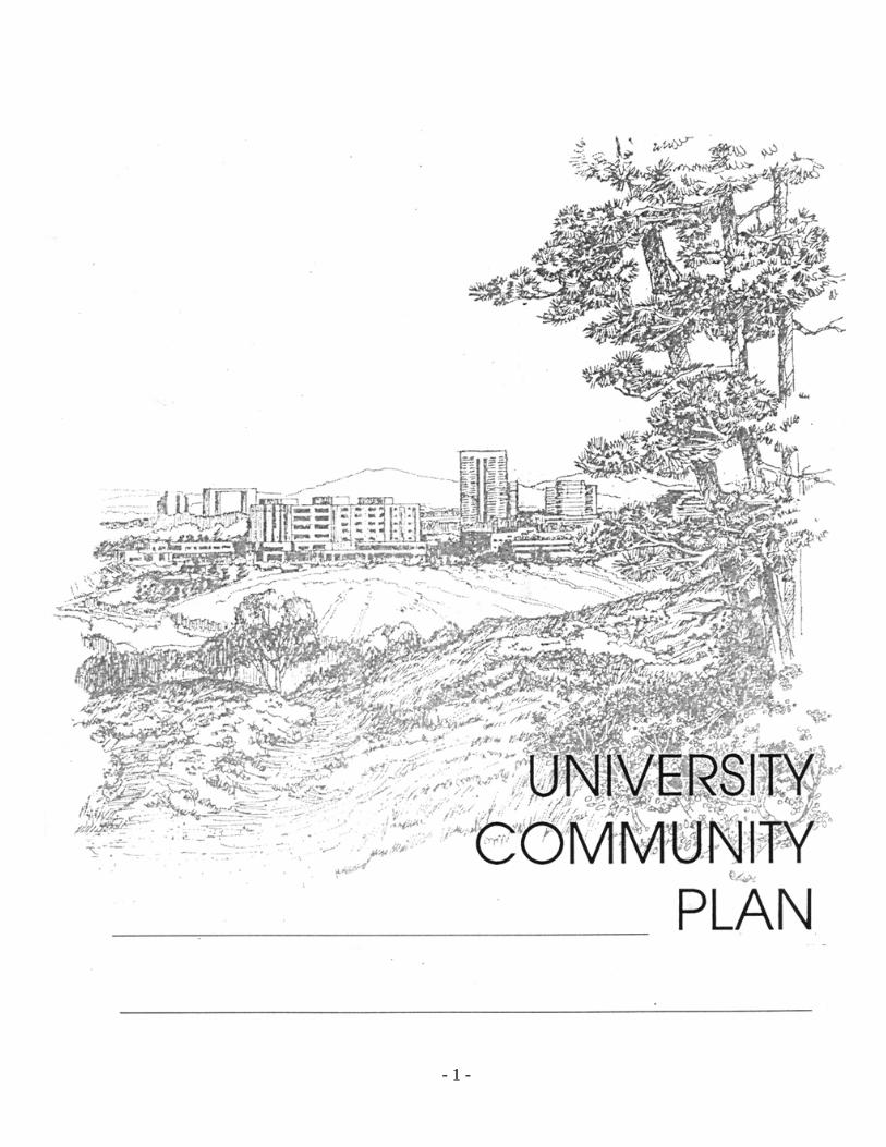
- 1 -


- i -
Community Plan
Prepared by
The University Community Planning Group and
City of San Diego Planning Department 202 C Street, MS 4A San Diego, CA 92101
Printed on recycled paper.
This information, or this document (or portions thereof), will be made available in alternative formats upon request.
University

- ii -
UNIVERSITY COMMUNITY PLAN AMENDMENTS The following amendments have been incorporated into this October 2014 posting of this plan:
Amendment Date Approved by
Planning Commission
Resolution Number
Date Adopted by City Council
Resolution Number
University Community Plan approved.
December 18, 1986 July 7, 1987 R-268789
Applied implementation of CPIOZ “B” and additional development guidelines for specific properties.
January 12, 1988 R-270138
Added Urban Design Element, miscellaneous consistency changes, and modifications to the 1987 community plan required by Coastal Commission.
January 16, 1990 R-274998
Added residential, office/commercial use and increased development intensity in Table 3, the Goodwin/Smith subarea 29 and reduced development intensity in Regents Park subarea 24
November 14, 2000
R-294148
Redesignated a portion of subarea 40 from commercial to multi-family residential and increased allowable development intensity
November 21, 2000
R-294273
Public safety services language amended
August 10, 2006 December 6, 2006 R-302145
Redesignated a portion of the Costa Verde subarea 47 from Visitor Commercial to High Density Residential
September 17, 2007
R-302997
Increased allowable development intensity on the University Towne Centre subarea 43 by 750,000 sf and a maximum 300 multi-family residential units
July 29, 2008 R-304023

- iii -
Added MCAS Miramar ALUCP policy language and deleted references and maps to the NAS Miramar CLUP.
February 17, 2011
April 26, 2011
R-306737
Redesignated a 5 ac portion of Goodwin/Smith subarea 29 from Scientific Research to Business Park and increased allowable development intensity
Mar 13, 2012 R-307324
Redesignated a 7.93 ac site in La Jolla Crossroads subarea 40 from Scientific Research to High Density Residential
December 04, 2012 R-307935
Increased the allowable development intensity from 20,000 sf/ac to 35,000 sf/ac of Scientific Research use on a 7.076 ac site in subarea 31
January 29, 2013 R-307980
Increased allowed square footage for medical office use and redesignated a portion of Scripps Memorial Hospital subarea 4 from Commercial Office to Public Facilities-Institutional
September 10, 2013 R-308380
Removed residential land use from the La Jolla Commons subarea (Subarea 29) in Table 3 of the Development Intensity Element and allowed the option to build office, hotel or office and hotel uses.
January 30, 2014 4579-PC February 24, 2014 R-308755
On August 14, 2014, amended the City of San Diego Local Coastal Program – Coastal Land Use Maps to include the North Coast Corridor Public Works Plan/Transportation and Resource Enhancement Program (NCC PWP/TREP) Project Overlay Map and Project Overlay Improvements Map.
PWP-6-NCC-13-0203-1

- iv -
MAYOR Maureen O’Connor DEPUTY MAYOR Abbe Wolfsheimer CITY COUNCIL Judy McCarty Ron Roberts Gloria McColl H. Wes Pratt Ed Struiksma J. Bruce Henderson Bob Filner CITY ATTORNEY John W. Witt CITY MANAGER John Lockwood PLANNING COMMISSION Karl ZoBell, Chairman Ralph Pesqueira, Vice-Chairman Yvonne Larsen Chris Calkins Lynn Benn Edward Reynolds Scott Bernet CITY PLANNING DEPARTMENT Robert Spaulding, Planning Director Michael Stepner, City Architect Planning Staff: Mary Lee Balko, Deputy Director Susan B. Baldwin, Senior Planner Ella Paris, Senior Planner Mike Westlake, Senior Planner Marilyn Millikan, Graphics Karen Y. Brooks, Word Processing Engineering and Development Staff: Allen Holden, Jr., Deputy Director Kris Berg, Senior Traffic Engineer

- v -
UNIVERSITY COMMUNITY PLANNING GROUP
Harry L. Mathis, Chairman
Sherm Harmer, Vice-Chairman Maureen O’Connor, Secretary
George W. Lattimer Ian S. Trowbridge Alcina Crull Patrick Tobin Bob Vilven Scott Spencer Nico Calavita Jack McRoskey Barry Rothman Ellen Lawson John Walsh Gina Zanotti Alice M. Tana Fred Pierson* John McQuown Milt Phegley
Additional members of the University Community Planning Group at the time of adoption of update July 7, 1987.
Ted Owen H. Steve Sanders Mark Glies Nancy D. Miller Ferdy Tagle Dr. Mary Wolshok Mary Grana* Danielle Warren-Angelucci Jim Whalen Roy Johnson*
* Non-Voting Members City Staff members involved in the Plan update adopted July 7, 1987
Allen M. Jones, Deputy Director Susan R. Peerson, Associate Planner Arnold Torma, Senior Traffic Engineer Phil Sanford, Associate Traffic Engineer
- vi -
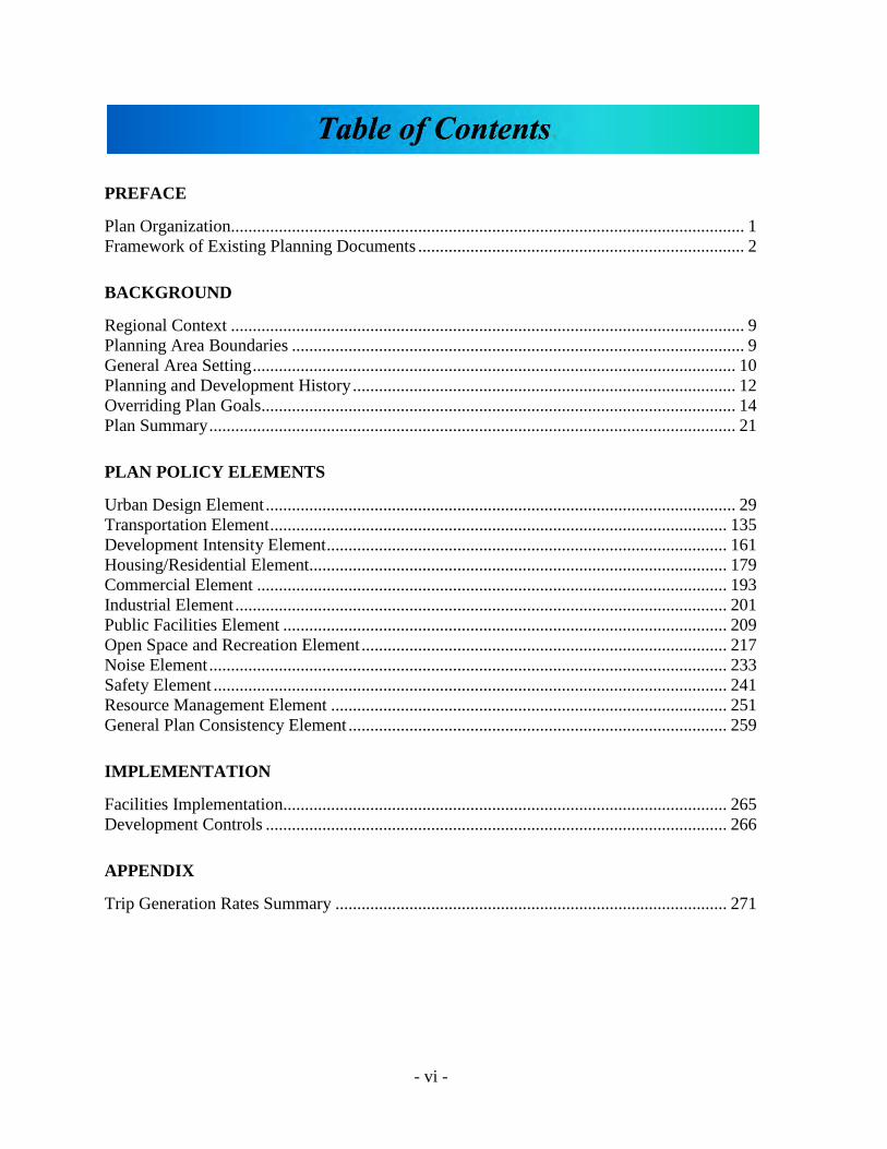
PREFACE
Plan Organization...................................................................................................................... 1 Framework of Existing Planning Documents ........................................................................... 2
BACKGROUND
Regional Context ...................................................................................................................... 9 Planning Area Boundaries ........................................................................................................ 9 General Area Setting ............................................................................................................... 10 Planning and Development History ........................................................................................ 12 Overriding Plan Goals............................................................................................................. 14 Plan Summary ......................................................................................................................... 21
PLAN POLICY ELEMENTS
Urban Design Element ............................................................................................................ 29 Transportation Element ......................................................................................................... 135 Development Intensity Element ............................................................................................ 161 Housing/Residential Element................................................................................................ 179 Commercial Element ............................................................................................................ 193 Industrial Element ................................................................................................................. 201 Public Facilities Element ...................................................................................................... 209 Open Space and Recreation Element .................................................................................... 217 Noise Element ....................................................................................................................... 233 Safety Element ...................................................................................................................... 241 Resource Management Element ........................................................................................... 251 General Plan Consistency Element ....................................................................................... 259
IMPLEMENTATION
Facilities Implementation...................................................................................................... 265 Development Controls .......................................................................................................... 266
APPENDIX
Trip Generation Rates Summary .......................................................................................... 271

- vii -
Figure 1. Framework of Existing Planning Documents ......................................................... 3 NCC PWP/TREP Project Overlay ................................................................................ Map 1A NCC PWP/TREP Project Overlay Improvements ........................................................ Map 2B Figure 2. Regional Location Map........................................................................................... 8 Figure 3. Vicinity Map ......................................................................................................... 11 Figure 4. Generalized Land Use Plan - 1989 ....................................................................... 20 Figure 5. Extent of Urbanization .......................................................................................... 30 Figure 6. Major Subareas ..................................................................................................... 34 Figure 7. 1989 - UCSD Long Range Development Plan ..................................................... 36 Figure 8. Proposed Street Widenings ................................................................................... 49 Figure 9. Community Unifying Roads ................................................................................. 66 Figure 10. Primary Pedestrian Network ................................................................................. 75 Figure 11. Pedestrian Crossings ............................................................................................. 78 Figure 12. Urban Node ........................................................................................................... 82 Figure 13. Torrey Pines Subarea #1 ....................................................................................... 96 Figure 14. Central Subarea #2 .............................................................................................. 110 Figure 15. Miramar Subarea #3 ............................................................................................ 122 Figure 16. South University Subarea #4 .............................................................................. 128 Figure 17. Traffic Volumes 1985-1986 ................................................................................ 136 Figure 18. Existing Transit Service - September 1988 ........................................................ 138 Figure 19. Projected Traffic Volumes .................................................................................. 145 Figure 20. Recommended Street Network ........................................................................... 146 Figure 21. Short Range Transit Plan .................................................................................... 148 Figure 22. Proposed Light Rail Transit and Shuttle Loop ................................................... 150 Figure 23. Bikeways ............................................................................................................. 153 Figure 24. Bicycle Facilities Classifications ........................................................................ 154 Figure 25. Bicycle Parking ................................................................................................... 157 Figure 26. Land Use and Development Intensity Subarea ................................................... 163 Figure 27. Community Plan Implementation Overlay Zone Map........................................ 175 Figure 28. Existing Residential Development ...................................................................... 180 Figure 29. Residential Densities ........................................................................................... 184 Figure 30. Residential Infill Parcels - South University ...................................................... 187 Figure 31. Single-Family Protection Map ............................................................................ 189 Figure 32. Community Commercial Land Use Distribution By Use ................................... 194 Figure 33. Commercial Land Uses ....................................................................................... 198 Figure 34. Industrial Land Uses ........................................................................................... 205 Figure 35. School Sites ......................................................................................................... 213 Figure 36. Developed and Undeveloped Park Sites ............................................................. 221 Figure 37. Open Space Proposals ......................................................................................... 224 Figure 38. Deleted ................................................................................................................ 234 Figure 39. Deleted ................................................................................................................ 235 Figure 40. Geologic Hazards ................................................................................................ 243 Figure 41. Deleted ................................................................................................................ 244 Figure 42. Deleted ................................................................................................................ 245

- viii -
Table 1. University Community Plan Land Use Summary .................................................. 23 Table 2. Bus Service Characteristics .................................................................................. 137 Table 3. Land Use and Development Intensity .................................................................. 164 Table 4. Development Intensities - Restricted Industrial ................................................... 169 Table 5. Existing Residential Densities .............................................................................. 179 Table 6. Community Balance Indicators ............................................................................ 181 Table 7. Proposed Residential Density ............................................................................... 183 Table 8. Public School Facilities ........................................................................................ 209 Table 9. Existing Park Inventory ........................................................................................ 220 Table 10. Functions of Community Open Space Areas ....................................................... 230

- ix -
Preface

- x -
THIS PAGE INTENTIONALLY LEFT BLANK.
- 1 -
PLAN ORGANIZATION The University Community Plan (Plan) is composed of four major sections. These sections proceed from providing general background information about the planning area through the formulation of a plan scheme, to the description of specific implementation procedures. Each of the sections has a separate, discrete function, which is abstracted in the following paragraphs.
I. PREFACE
This section briefly overviews the organization and framework within which the Plan has been drafted.
II. BACKGROUND
The purpose of this section is to briefly describe the planning area, its setting, regional context, and planning history.
III. PLAN ELEMENTS
The Plan Elements of the Plan are discussed in this section. A comprehensive Urban Design Element provides a vision of the future character of the community, and makes recommendations regarding transportation linkages and urban design criteria for development in four subareas: Torrey Pines, Central, Miramar and South University. The other Plan elements establish policies relating to land use, transportation, public facilities, etc.
IV. IMPLEMENTATION
Ongoing plan implementation programs effecting development review and the provision of public facilities are listed in this final section. (Implementation of the recommendations in the Urban Design Element is included therein.)
- 2 -
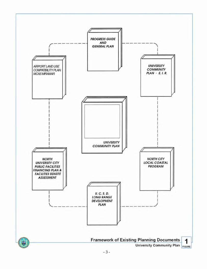
FRAMEWORK OF EXISTING PLANNING DOCUMENTS Much of the organizational framework of the Plan comes from the several related documents which, along with the Plan, establish planning and development controls within the community (Figure 1). The Plan is not an isolated document; rather, it represents a refinement of citywide goals contained in the City’s Progress Guide and General Plan (General Plan) and earlier community plans. The Plan can be thought of as one volume in a library of pertinent documents which includes the General Plan, as well as the North University City Public Facilities Financing Plan and Facilities Benefit Assessment, the Airport Land Use Compatibility Plan for Marine Corps Air Station (MCAS) Miramar (formerly Naval Air Station Miramar), the UCSD Long-Range Development Plan, the North City Local Coastal Program and the University Community Plan Environmental Impact Report.
I. PROGRESS GUIDE AND GENERAL PLAN
The General Plan sets forth goals and objectives for the development of San Diego to the year 1995. It establishes the amount of land needed for various uses, and designates general locations for these uses while relating each to the other. It projects the transportation networks necessary to link all future facilities and to permit them to function efficiently. Finally, it enunciates recommendations and measures for achieving General Plan goals and objectives. With respect to community planning areas, the General Plan establishes a framework for the development of more specific community plans by identifying and locating those facilities that possess citywide or inter-community importance. Moreover, the General Plan provides goals, standards and criteria relating to the need for, and the location of such essential intra-community facilities as neighborhood centers, neighborhood parks, and elementary schools. Within the framework of the General Plan, community plans such as this one are prepared. The Plan relies heavily on the goals and recommendations contained in the General Plan.
II. NORTH UNIVERSITY CITY PUBLIC FACILITIES PLAN AND FACILITIES
BENEFIT ASSESSMENT
The General Plan recommends the division of the City into “Urbanized,” “Planned Urbanizing” and “Future Urbanizing” areas. The North University portion of the University community is designated in the General Plan as a “Planned Urbanizing” area. City Council Policy 600-28 requires that a plan for the implementation of public facilities be prepared for such urbanizing areas. In order to fulfill the requirement of this policy, the North University City Public Facilities Financing Plan and Facilities Benefit Assessment (FBA) (Financing Plan) has been prepared. This implementation program contains a development forecast and analysis, a summary of existing conditions with respect to public facilities, and a Capital Improvement Program (CIP) which lists needed facilities and an analysis of proposed and recommended financing sources. The Financing Plan also includes a development phasing plan to ensure
- 3 -
Figure 1. Framework of Existing Planning Documents

- 4 -
that facilities are provided at their time of need. The object of the FBA, as stated in Council Policy 600-28, is to assure that public improvements in Planned Urbanizing areas will be furnished and financed by the private developers of the community.
III. AIRPORT LAND USE COMPATIBILITY PLAN FOR MCAS MIRAMAR
The Airport Influence Area for MCAS Miramar affects the University Community. The Airport Influence Area serves as the planning boundaries for the Airport Land Use Compatibility Plan for MCAS Miramar. Airport Influence Area Review Area 1 is comprised of the noise contours, safety zones, airspace protection surfaces, and overflight areas. Airport Influence Area Review Area 2 is comprised of the airspace protection surfaces and overflight areas. The Airport Land Use Commission for San Diego County adopted the Airport Land Use Compatibility Plan for MCAS Miramar to establish land use compatibility policies and development criteria for new development within the Airport Influence Area to protect the airport from incompatible land uses and provide the City with development criteria that will allow for the orderly growth of the area surrounding the airport. The policies and criteria contained in the Airport Land Use Compatibility Plan are addressed in the General Plan (Land Use and Community Planning Element and Noise Element) and implemented by the supplemental development regulations in the Airport Land Use Compatibility Overlay Zone within Chapter 13 of the San Diego Municipal Code. Planning efforts need to address airport land use compatibility issues consistent with airport land use compatibility policies and regulations mentioned above.
IV. UCSD LONG-RANGE DEVELOPMENT
Because of the major role played by the University of California San Diego (UCSD) in the development of the community, the UCSD Long-Range Development Plan (LRDP) is an important document in the Plan “library.” The UCSD LRDP provides data that is essential to the programming of municipal public services and private development to support the University.
V. NORTH CITY LOCAL COASTAL PROGRAM
The California Coastal Act of 1976 requires all jurisdictions within the Coastal Zone to prepare a Local Coastal Program. The Local Coastal Program includes issue identification, a land use plan, and implementation ordinances. In order to respond to individual community concerns, the Local Coastal Program of the City of San Diego has been divided into twelve segments. The Coastal Zone portions of the University community have been incorporated into the North City Local Coastal Program segment. The North City Local Coastal Program also encompasses portions of the community plan areas for Torrey Pines, North City West, Mira Mesa, Sorrento Hills, La Jolla and the adjacent open space and urban reserve areas identified in the General Plan. These areas are being considered as a group because of their unique resource inter-relationships created by the Los Peñasquitos and San Dieguito drainage basins.

- 5 -
Both the Plan and the North City Local Coastal Program Land Use Plan are components of the City’s total Local Coastal Program. The plan identifies the basic land use, development intensity and circulation system within its coastal areas. The North City Local Coastal Program Land Use Plan further clarifies and adds specific coastal resource protection policies needed to satisfy the requirements of the Coastal Act. Both plans are designed to be compatible with each other. Where any apparent conflict exists, the North City Local Coastal Program Land Use Plan shall apply.
VI. UNIVERSITY COMMUNITY PLAN ENVIRONMENTAL IMPACT REPORT
Because the Plan contains long-term use and development controls for the area and refines the General Plan, it carries implications for the future quality of the community and regional environment. The adoption of a plan such as this requires the certification of a completed environmental review, as specified by the Environmental Quality Act of 1970. The California Environmental Impact Report (EIR), which is circulated as a companion document to this Plan, is intended to fulfill the requirements of that Act. In addition, some of the information contained in the Plan EIR is of sufficient detail to allow it to function as a Master Environmental Assessment in a manner described by Section 15069.6 of the State EIR Guidelines.
VII. NORTH COAST CORRIDOR PUBLIC WORKS PLAN/TRANSPORTATION
AND RESOURCE ENHANCEMENT PROGRAM.
The approval of the North Coast Corridor Public Works Plan/Transportation and Resource Enhancement Program (NCC PWP/TREP) by the California Coastal Commission in 2014 (Doc. No. PWP-6-NCC-13-0203-1) amended the City’s Local Coastal Program, and requires that subsequent regulatory reviews of projects encompassed by the NCC PWP/TREP be processed under the framework and guidance provided within the NCC PWP/TREP. This amendment of the City of San Diego Local Coastal Program included amendments to the Coastal Land Use Maps contained within the University Community Plan to include the NCC PWP/TREP Project Overlay Map (Map 1A) and Project Overlay Improvements Map (Map 2B). The NCC PWP/TREP Project Overlay provides the applicable standard of review for the NCC PWP/TREP, which authorizes the development, operation, and maintenance of specific rail, highway, transit, bicycle, pedestrian, community and resource enhancement projects defined therein. The City of San Diego Local Coastal Program NCC Project Overlay Improvements Map identifies those specific rail, highway, transit, bicycle, pedestrian, community and resource enhancement projects envisioned to occur within the jurisdictional boundaries of the University Community Plan pursuant to the NCC PWP/TREP. To the extent any other provisions of the community plan conflict with the NCC PWP/TREP, the provisions of the NCC PWP/TREP shall prevail.

- 6 -
THIS PAGE INTENTIONALLY LEFT BLANK

- 7 -
Background

- 8 -
Figure 2. Regional Location Map

- 9 -
REGIONAL CONTEXT The traditional concept of the University community planning area as a student-oriented “college town” has undergone a great change in the last decade. The evolution of the community into a major “urban node” has been facilitated by the development of the University Towne Centre as a regional shopping center, the expansion of the Torrey Pines “science/research” concept to include corporate headquarters, and the accessibility of the community to the regional transportation system (Figure 2). Thus, while present and anticipated uses in many ways are complementary to the functions of UCSD, the design and scale of the community are more oriented toward providing a professional environment rather than one that caters specifically to student needs. Some of this orientation may result from UCSD’s status as a nationally respected research university. This trend has become a concern of many residents of the community. The current prospects for the community, as evidenced by recent project approvals, is one of high-intensity, innovative, mixed-use development on a scale unmatched by any new urbanizing community of the City. While any loss of potential downtown uses to an urbanizing area such as the University community incrementally erodes efforts to redevelop downtown, the drawing power that the community has demonstrated in attracting new jobs and industries is an asset to the City as a whole. It can also be argued that the function of the University area as an education, research, health services and office park center is dissimilar to the financial, government and cultural functions that are predominant in the downtown area. On the whole, however, the development of a high-intensity University area may be of benefit to the region to the extent that it precludes sprawl or unplanned premature development in the peripheral areas of the City.
PLANNING AREA BOUNDARIES The University community planning area encompasses approximately 8,500 acres. As Figure 3 indicates, the area is bounded by Los Peñasquitos Lagoon and the toe of the east-facing slopes of Sorrento Valley on the north, the tracks of the Atchison, Topeka, and Santa Fe Railroad, MCAS Miramar and Interstate 805 (I-805) on the east, State Route 52 (SR-52) on the south, and Interstate 5 (I-5), Gilman Drive, North Torrey Pines Road, La Jolla Farms and the Pacific Ocean on the west. Neighboring communities include Torrey Pines, Mira Mesa, Clairemont and La Jolla. It should be noted that the planning area contains two state-controlled properties—UCSD and Torrey Pines State Reserve—which lie outside the zoning jurisdiction of the City.
- 10 -
GENERAL AREA SETTING Internally, the University community planning area is characterized by its dominant existing uses, its topography and its major environmental constraints. Taken together, these factors will continue to control the development of the community.
I. DOMINANT EXISTING USES
Historically, UCSD has been the focal point of the community. Its continuing evolution has established much of the scale, intensity and pace of private development in the community. A second major focus has been developed in the form of the University Towne Centre, which functions as a major regional commercial center as well as a social center for the community. The research, corporate headquarters and medical centers in the northern portion of the planning area, the major parkland resources of the Torrey Pines, Rose Canyon and San Clemente Canyon areas, and the urbanized South University residential area make up the other major existing uses in the community.
II. TOPOGRAPHY
The landform of the University community planning area is highly varied, consisting of such major topographic features as coastal bluffs, canyon systems, areas of rolling topography and mesa tops. The coastal bluffs are the most scenic landform in the community and lie entirely within the Torrey Pines State Reserve and Torrey Pines City Park. Major canyon systems in the community include Sorrento Valley, Soledad Canyon, Rose Canyon and San Clemente Canyon. In the vicinity of the Towne Centre, the topography is a series of side canyons and rounded ridges which form the transition from the more pronounced major canyons to the mesa tops which generally lie in the vicinity of Miramar Road, north of University Towne Centre and north of UCSD.
III. ENVIRONMENTAL CONSTRAINTS
The environmental constraints which exist in the University community planning area originate from both natural and man-made sources. Major natural constraints are imposed by the habitat and scenic values of the slope areas associated with the coastal zone and the canyon open space systems. Significant man-made constraints include the overflight impacts associated with MCAS Miramar, limitations on access and traffic handling capability and air quality considerations.

- 11 -
Figure 3. Vicinity Map
- 12 -
PLANNING AND DEVELOPMENT HISTORY
In December 1956, the Regents of the University of California presented a report to the State Legislature entitled, “A Study of the Need for Additional Centers of Public Higher Education in California.” This report emphasized the steadily increasing enrollment at all branches of the University and recommended that priority be given to the selection of sites for new general campuses to accommodate the growing need for higher education facilities. It was estimated that a need existed within Southern California for two new major campuses to accommodate an eventual enrollment of 25,000 students each. Twenty-three different sites within the general San Diego metropolitan area were given careful consideration prior to the selection of a site on the Torrey Pines Mesa north of La Jolla. On July 18, 1958, the Board of Regents passed a resolution which stated “... that a Master Plan of land use in the area can give assurances of necessary housing and community development for services and convenience of a large campus.” In response to the Board of Regents’ statement and the recommendation of the City Planning Commission, the San Diego City Council endorsed the planning concept by adopting Resolution No. 149364 on August 14, 1958, to “... prepare the new Master Plan of the area adjacent to the proposed La Jolla site of the University of California, including a compatible land use plan and a local highway system to adequately serve the proposed University and its environs.” The original Master Plan was adopted by the City Council in January 1960. Most of the University community’s growth during the 1960s occurred in the primarily single-family South University area. During this period, three plan amendments were approved by the City Council in 1961, 1963 and 1965, which reflected modifications in the requirements of the University, the surrounding community and the region. A new plan was drafted in the late 1960s and adopted in 1971. Subsequent to the adoption of the 1971 plan, the Town Centre core evolved from concept to reality, the impact of the (former) NAS Miramar aircraft noise and accident potential was clearly defined, land market conditions changed in the area, UCSD student population projections were revised and facilities financing proposals contained in the General Plan were pursued through the adoption of new Council policies. In response to these changing conditions, the Planning Department was directed to revise the University Community Plan. For the purpose of providing citizen input, the Council recognized the University Community Planning Group (UCPG) composed of residents, property owners, business people and representatives of UCSD. This effort resulted in the adoption of the 1983 community plan. In March of 1985, the City Council reviewed and approved a work program to update the 1983 Plan. In conjunction with the Plan update, the City Council voted to adopt an Emergency Building Limitation Ordinance restricting development in the University community to the level specified in the 1983 Plan. This ordinance was adopted to ensure that during the update development would not occur which might preclude a workable circulation system.

- 13 -
The primary goal of the work program for the Plan was to revise the 1980 Land Use Forecast (Appendix 3 of the 1983 Plan). In the 1983 Plan, the community was divided into subareas and assigned land uses and development intensities which were tested in a community-wide traffic forecast. The update of this forecast has corrected errors, incorporated changes in land use and development intensity assumptions and provides a means of implementing the changes. At the Planning Commission’s direction, the Planning Department tested various land use and development intensity assumptions for inclusion in the traffic study. As a result of these studies and numerous workshops, the Planning Department recommended land uses and development intensity allocations in the Development Intensity Element. These land uses and development intensities were modified by the City Council based on recommendations by the University Community Planning Group and requests by various property owners upon adoption of the Plan on July 7, 1987 (R-268789). The City Council also directed at that time that all development in the northern portion of the community be approved through a discretionary permit and that an Urban Design Element be prepared for the Plan. The Community Plan Implementation Overlay Zone (CPIOZ) Type B was applied to those properties not otherwise subject to discretionary review in the northern portion of the community, and the plan amended to identify said properties on January 12, 1988 (Resolution No. R-270138 and Ordinance No. 0-17016). The Urban Design Element has also been incorporated as of January 16, 1990 (Resolution No. R-274998).

- 14 -
OVERRIDING PLAN GOALS A series of general goals for the development of land have been established by the General Plan. In the context of the General Plan, the goals are applied to the analysis of citywide alternative plan schemes.
I. GENERAL PLAN GOALS
Broadly speaking, the goals used for alternatives analysis in the General Plan are directed toward four basic areas of concern, including: (1) facilitating and providing capital improvements for appropriate new growth in an efficient manner, (2) encouraging economically, socially and racially balanced communities, (3) minimizing the environmental and design consequences of urban development, and (4) providing for a development framework which is compatible with regional plans and programs. The following is a summary of the General Plan Goals:
A. Residential Growth
1. Management of the growth of the region through appropriate population
assimilation without artificial constraints or limitations on growth increases. 2. Recognition that a proper development management system operates as a
positive intervention to appropriately distribute growth with suitable environmental and physical performance standards.
B. Fiscal-Economic
1. Reduction in costs of development—particularly public capital and operational
costs and stabilizing the tax structure of the City by discouraging urban sprawl. 2. Making more efficient use of existing community facilities and improvements.
C. Balancing Social and Community Characteristics in All Areas 1. Balanced housing for all communities and income levels. 2. Proximity of place of employment and residence.
3. Recognition of community and individual economic, social and physical
values. 4. The “quality of life” in new neighborhoods through provision of adequate
public facilities at time of development.

- 15 -
D. Preservation and Enhancement of Established Neighborhoods
1. Establishment of performance standards to guide the conservation of valued existing neighborhood characteristics.
2. Encouragement of private finance mechanisms for preservation of established
neighborhoods. 3. Encouragement of infill within City neighborhoods where vacant land and
adequate public facilities exist.
E. Preservation of Environmental Quality 1. Management of natural resources–floodplains, vegetation, aquifers, slopes,
hillsides, canyons, coastal and waterfront areas. 2. Preservation of open space and vistas. 3. Reduction of air, noise and water pollution.
F. Maintaining a Viable Housing Market 1. Elimination of administrative delay in the processing of land development
permits. 2. Identification of areas which can urbanize in a 20-year period in order to move
from a system of unknowns to an ordered and prioritized land use and legal system.
3. Creation and maintenance of a stable inventory of residential land which
provides certainty that development can occur. 4. Encouragement of a steady level of housing starts (absent private market
interferences) to assure continuing construction industry activity and employment.
5. Creation of new development opportunities in selective areas bypassed by
market forces through governmental incentives.
G. Encouragement of Inter-Regional Cooperation
Development of a framework for the City and region which requires intergovernmental cooperation between local, county and regional agencies in which critical regional problems can be resolved such as: 1. Boundary adjustment (spheres of influence).

- 16 -
2. Allocation of regional residential growth. 3. Provision for utility extensions (sewer and water). 4. Coordination of the major public improvement of special districts. 5. Location of regional, commercial and industrial centers. 6. Establishment of transportation systems. 7. Social, fiscal-economic and housing considerations. 8. Air and water quality decisions.
II. COMMUNITY GOALS
In the same fashion that the General Plan goals establish useful criteria for evaluating community plan alternatives in light of the external or regional context of the planning process, the following goals are particularly suited to the University community. These goals are also important guidelines in the selection of a community plan and the design of its unique features. A. Overall Community Goals
1. Foster a sense of community identity by use of attractive entry monuments in
private developments. 2. Create a physical, social and economic environment complementary to UCSD
and its environs and the entire San Diego metropolitan area. 3. Develop the University area as a self-sufficient community offering a balance
of housing, employment, business, cultural, educational and recreational opportunities.
4. Create an urban node with two relatively high-density, mixed-use core areas
located in the University Towne Centre and La Jolla Village Square areas. 5. Develop an equitable allocation of development intensity among properties,
based on the concept of the “urban node.” 6. Provide a workable circulation system which accommodates anticipated traffic
without reducing the Level of Service below “D.”
- 17 -
B. Housing Goals
1. Provide a broad range of housing types and costs to accommodate various age groups, household sizes and compositions, tenure patterns (renter/owner-occupied) and income levels.
2. Encourage housing for students and employees of the University and life
sciences-research facilities. 3. Locate higher density housing nearest the University, the Towne Centre core
and La Jolla Village Square. 4. Provide affordable housing for low- and moderate-income households by
encouraging the following efforts of the City of San Diego:
a. Utilization of selected City-owned properties for housing development; b. Utilization of federal rental subsidy programs and state mortgage assistance
programs; and c. Stimulation of greater use of modular and other innovative cost-saving
building techniques.
5. Encourage religious and other nonprofit organizations to develop and operate rental and cooperative housing for low- and moderate-income households.
6. Encourage a mixture of residential, commercial and professional office uses. 7. Encourage the provision of non-structured recreation areas such as open
grassed playing fields.
C. Employment Goals 1. Promote job opportunities within the University community. 2. Encourage the development of life sciences-research facilities which maximize
the resources of the University.
D. Commercial Goals 1. Provide a complete range of goods and services for the residents of the
University community. 2. Concentrate community activities such as retail, professional, cultural,
recreational and entertainment within the Towne Centre and La Jolla Village Square.

- 18 -
3. Accommodate professional offices and laboratory facilities and services to complement the University, the Towne Centre and the life sciences-research facilities.
4. Strategically locate neighborhood convenience centers throughout the
residential areas.
E. Open Space Goals 1. Preserve the present amenities of San Clemente, Rose Canyon and other
primary canyons within the community. 2. Preserve the natural environment including wildlife, vegetation and terrain. 3. Permit uses within canyons which are strictly compatible with the open space
concept. 4. Ensure that all public improvements such as roads, drainage channels and
utility services and all private lessee developments are compatible with the natural environment.
F. Public Facilities and Services Goal
Ensure that schools, parks, police and fire protection, sewer and water, library and other public facilities are available concurrently with the development which they are to serve.
G. Transportation Goals 1. Develop a transportation system designed to move people and goods safely and
efficiently within the community, including linkages with other communities, and with due consideration for energy conservation.
2. Encourage the adequate provision of public transit between major activity
areas such as the University, the Towne Centre and La Jolla Village Square. 3. Provide pedestrian paths and bikeways to accommodate the community and
complement the citywide systems. 4. Encourage alternative modes of transportation by requiring developer
participation in transit facility improvements, the Intra-Community Shuttle Loop and the Light Rail Transit (LRT) system.
5. Ensure implementation of City Council Policy 600-34, Transit Planning and
Development.

- 19 -
H. Community Environment Goals
1. Provide attractive community entryways. 2. Minimize the impact of aircraft noise and the consequences of potential aircraft
accidents. 3. Foster individuality and identity of area throughout the community. 4. Ensure that the physical development of the community takes advantage of the
site and terrain. 5. Encourage architectural styles and building forms suited to San Diego’s
landscape and climate. 6. Limit traffic conditions which produce congestion and air pollution. 7. Provide street and median trees along streets within the community.
I. Industrial Goals
Emphasize the citywide importance of and encourage the location of scientific research uses in the North University City area because of its proximity to UCSD.

!"̂$
!"̂$
%&s(
?nES
SS
S
SS
SCRIPPSHOSP
UCSD
UCSD
UCSD
S.D.
G.& E
.R.0
.W.
PACI
FIC O
CEAN
A.T.& S.F. RR
VAHOSP
S
GENE
SEE A
V
GILM
AN D
R
LA JOLLA VILLAGE DR
REGE
NTS R
D GOVERNOR DR
NORT
H TO
RREY
PINE
S RD
LA JO
LLA C
OLONY
DR
EXECUTIVE DR
REGENTS RD
Generalized Land Use PlanUniversity Community Plan 4
FIGURE
LAND USE CATEGORIES
PARK
SCHOOLS
RESIDENTIAL
PUBLIC/SEMI-PUBLIC
COMMERCIALINDUSTRIAL
OPEN SPACE
PUBLIC FACILITIES/INSTITUTIONAL
U.C.S.D. BOUNDARYCOASTAL ZONE BOUNDARY
COMMUNITY BOUNDARY
³
BUSINESS PARK

- 21 -
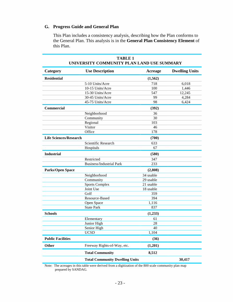
PLAN SUMMARY I. LAND USE
The Plan as illustrated in Figure 4 is a generalized visual representation of the major land use proposals as set forth in the Plan elements which follow. Obviously, it does not stand alone and the text of the Plan is equally necessary in interpreting the intent of the City of San Diego with respect to the University community. This Plan is an update of the 1983 University Community Plan which established the land use and development intensities for the community. The emphasis of this Plan is to respond to the community-wide land use needs and achieve a balance of uses while providing a future circulation system which accommodates the level and types of development expected at buildout. The final implementation of the land uses shown is intentionally not tied to any targeted date. A further refinement of the land use proposals shown on the community plan map is the land use table which is included in the Development Intensity Element of the Plan. It is the purpose of this table to establish the permitted intensity of uses and to coordinate that intensity to the future public facilities of the community. The summary of uses and acreages in Table 1 is derived from totaling the land use types in the land use and development intensity table.
II. PROPOSALS
A summary of the major development policies and land use proposals contained in this Plan which affect the land uses shown on the community plan map include: A. Traffic and Transportation
The land use proposals in the Plan are tied to a travel forecast conducted in 1986, and revised to include the development intensities adopted by the City Council on July 7, 1987. In fact, the Transportation Element of this Plan establishes the travel forecast as the recommended ceiling of development intensity in the community. As discussed in the Development Intensity Element of the Plan, it is not, however, intended that traffic generation be the sole basis on which projects are judged. In July of 1985 a survey of landowners was conducted to determine existing and proposed development for the University community. The Planning Department reviewed this information, and the land use files of the City, and proposed land uses and development intensities supportive of the goals of the Plan. Higher densities were proposed for the two relatively high-intensity, mixed-use urban core areas, while lower intensities were proposed towards the edges of the community. The land uses and development intensities included in the community plan were tested in the 1986 traffic forecast. (A final forecast was prepared following the adoption of the Plan.)
- 22 -
Street improvements and other public facilities in support of the 1986 forecast (as revised), above and beyond the 1983 Plan, will be incorporated as part of the North University City Public Facilities Financing Plan and Facilities Benefit Assessment. Further studies on transit improvements and financing are currently being reviewed. These studies include the Metropolitan San Diego Short Range Transit Plan, the North University City Intra-community Shuttle Loop Financing Plan and the Mid-Coast Light Rail Transit (LRT) alignment studies.
B. MCAS Miramar Overflight Impacts
Land use proposals, as well as the Noise and Safety Elements of the Community Plan Draft, have been prepared in conformance with the Airport Land Use Compatibility Plan for MCAS Miramar. The plan references the Federal Government’s easement acquisition and enforcement program as a controlling land use planning factor in the areas both east and west of Interstate 805.
C. UCSD Long Range Development Plan
This Plan more fully recognizes the importance of UCSD in the community by considering on-campus uses as designated by the University’s Long Range Development Plan (LRDP) and by seeking to provide appropriate linkages and design interfaces between the campus and the community. The plan includes uses that are supportive of the University’s basic goals of instruction and research.
D. Urban Design
An Urban Design Element has been added to the Plan, enhancing and replacing the Subarea Elements which were designated in the 1983 community plan for the purpose of refining land uses and design standards. This element provides a future vision of the University community and recommendations to achieve that vision. The Community Plan Implementation Overlay Zone (CPIOZ) has been applied to implement the urban design guidelines as well as the Development Intensity Element. The Development Intensity Element identifies properties to be reviewed under the CPIOZ.
E. Housing/Community Balance
In accordance with the Housing Element of the General Plan, proposals in the Plan call for the development of affordable housing within the community and recommend the use of City-owned properties for this purpose. The Plan also identifies density bonuses as a means of encouraging developers to provide moderate-income housing.
F. State Coastal Act
The land use and site preparation guidelines contained in the Plan are consistent with the adopted proposals contained in the North City Local Coastal Program Land Use Plan. The Planning Commission and City Council adopted these proposals affecting the Coastal Zone in March 1981.
- 23 -
G. Progress Guide and General Plan
This Plan includes a consistency analysis, describing how the Plan conforms to the General Plan. This analysis is in the General Plan Consistency Element of this Plan.
TABLE 1 UNIVERSITY COMMUNITY PLAN LAND USE SUMMARY
Category Use Description Acreage Dwelling Units
Residential (1,562) 5-10 Units/Acre 718 6,018 10-15 Units/Acre 100 1,446 15-30 Units/Acre 547 12,245 30-45 Units/Acre 99 4,284 45-75 Units/Acre 98 6,424 Commercial (392) Neighborhood 36 Community 30 Regional 103 Visitor 46 Office 178 Life Sciences/Research (700) Scientific Research 633 Hospitals 67 Industrial (580) Restricted 347 Business/Industrial Park 233 Parks/Open Space (2,808) Neighborhood 34 usable Community 29 usable Sports Complex 21 usable Joint Use 18 usable Golf 359 Resource-Based 394 Open Space 1,116 State Park 837 Schools (1,233) Elementary 61 Junior High 28 Senior High 40 UCSD 1,104 Public Facilities (36)
Other Freeway Rights-of-Way, etc. (1,201)
Total Community 8,512
Total Community Dwelling Units 30,417 Note: The acreages in this table were derived from a digitization of the 800 scale community plan map
prepared by SANDAG.

- 24 -
THIS PAGE INTENTIONALLY LEFT BLANK.

- 25 -
Plan Policy Elements

- 26 -

- 27 -
Urban Design Element

- 28 -
Acknowledgement
In appreciation to the M.W. Steele Group Incorporated for providing the sketches which appear in this publication.
- 29 -
URBAN DESIGN ELEMENT INTRODUCTION This element of the Plan defines the relationship of buildings and spaces and provides direction for public street improvements. These policies will be used to guide the form of urban growth in the community by providing the basis for reviewing proposed projects. The Urban Design Element provides developers and design professionals with explicit project design criteria. The scope and nature of the recommendations included herein reflect the fact that development patterns in this community have been firmly established in recent years. There is little vacant land located within the community boundaries (See Figure 5). The objectives and recommendations included in this element will apply to all new developments, additions and amendments to previously approved special permits. Requests for community plan amendments, as well as amendments to previously approved special permits, may require compliance with this Urban Design Element, not only on the amended portion, but also on portions of the projects approved but not yet built. Major urban design issues in the University community which can still be addressed relate to community coherence and the needs of the pedestrian. Well-defined, multi-modal, unifying linkages must be provided to integrate the various components of the community. New developments must respect existing natural resources and relate well to adjacent projects. The design of new buildings and spaces must also enhance the pedestrian experience. Extensive surveys, research and “awareness field trips” preceded the preparation of this element. Many community meetings and workshops were held to investigate urban design solutions for future development. This element is organized into four parts. The first part is a vision for the community’s future. The second part lists overall urban design goals. The third part discusses linkages (auto, pedestrian, bicycle and transit). The fourth part provides urban design criteria for private developments within the four major subareas of the community shown in Figure 6.

!"̂$
!"̂$
%&s(
?nES
SS
S
SS
SCRIPPSHOSP
UCSD
UCSD
UCSD
S.D.
G.& E
.R.0
.W.
PACI
FIC O
CEAN
A.T.& S.F. RR
VAHOSP
S
GENE
SEE A
V
GILM
AN D
R
LA JOLLA VILLAGE DR
REGE
NTS R
D GOVERNOR DR
NORT
H TO
RREY
PINE
S RD
LA JO
LLA C
OLONY
DR
EXECUTIVE DR
REGENTS RD
Extent of UrbanzationUniversity Community Plan 5
FIGURE
LAND USE CATEGORIES
PARK
SCHOOLS
RESIDENTIAL
PUBLIC/SEMI-PUBLIC
COMMERCIALINDUSTRIAL
OPEN SPACE
PUBLIC FACILITIES/INSTITUTIONAL
U.C.S.D. BOUNDARYCOASTAL ZONE BOUNDARY
COMMUNITY BOUNDARY
³
BUSINESS PARK

- 31 -
5. Extent of Urbanization
A Vision of the Future

- 32 -
- 33 -
I. UNIVERSITY COMMUNITY: A VISION OF THE FUTURE The urban design recommendations for the University community support a comprehensive vision of how the University community might look, feel and function in the next century. This vision of the future University community cannot ignore the established patterns of development. Rather, it must build upon the accomplishments of the past. The images which follow will serve as the framework for public and private sector decisions regarding future community development.
A. Character
The University community at the turn of the century is envisioned as a spacious, park-like community with buildings and land uses of strong identity, both visually and functionally. The UCSD campus, Salk Institute, Scripps Clinic and Research Foundation, and Torrey Pines State Reserve, are some examples of the uses presently located within the community. As the University and the community build out, additional institutions and research facilities will be attracted to this location because of the direct connection between scientific research uses and University campuses. The area’s importance as a major center for scientific research will continue to grow, distinguishing the University community from the other major urban centers in the region: downtown and Mission Valley. In the Central community, future buildings and additions to existing buildings will be better related to the streets and to the needs of the pedestrian. The street levels and street yards of existing developments within the community’s urban node in the vicinity of the Towne Centre will be retrofitted and made more comfortable and inviting for pedestrians. This will be accomplished through appropriate infill development and the addition of relatively minor exterior improvements such as art, pedestrian scale entrances and windows, directional graphics, fountains, places to sit, play and people-watch, open air theaters and markets, restaurants, cafes, vendors and other amenities. Pedestrian-oriented activities would be visible from the street and accessible not only from off-street parking areas but also directly from the public sidewalk. The top stories and roofs of buildings will provide places for people that include fitness/sports areas, eating places, gardens, meeting rooms and other uses which maximize view opportunities for a greater number of building users. The Southern California climate is to exert even more influence in the architecture, color, materials, site planning and building techniques of developments. The use of more balconies, terraces, atriums, landscaped courtyards, light colors and earthy materials will be increasingly important. Sun and view enjoyment will continue to be prime design considerations.

- 34 -
Figure 6. Major Subareas

- 35 -
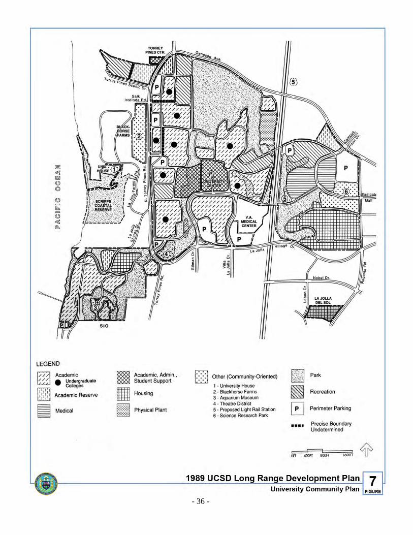
B. The UCSD Campus
The University campus will no longer be an island within the community. Some campus buildings will be located close to the street and be accessible to pedestrians directly from the public sidewalk. There will be limited auto traffic in the middle of the campus. Autos will be intercepted at the fringes in strategically located parking structures. Transit loops, bicycle and foot paths will greatly improve movement within the large campus and connect with the rest of the community. An LRT system will be used by the majority of people who work at, reside in and attend UCSD. Consistent with the UCSD Long Range Development Plan (Figure 7), the heart of the west campus will be a primary center providing services for students and faculty. Bookstores, restaurants, administration and health services will be located here. The East Campus will include facilities which relate as much to the community as to the campus such as the Satellite Medical Facility, the Science Research Park, the University Extension School, a campus events center, a light rail station and various recreational uses. These facilities will provide greater opportunity for community residents to enjoy the academic ambiance and to take advantage of educational and cultural exchange activities offered by the University. The eastern edge of the UCSD campus abutting Regents Road will provide the focal point for pedestrian interaction between the University, residents, visitors and employees of the community. The location of the Extension School along Regents Road just north of the existing student housing will greatly facilitate this community/University interaction.
C. Linkages
Numerous natural canyons link the community and will provide visual relief from urbanization as well as recreational opportunities. Similarly, there will be a clearly defined pedestrian network linking the principal activities and resources of the community. Pedestrians using the network will discover and experience both the natural and man-made assets of the area. Street sidewalks, paved paths through private property and trails through canyon areas will form the primary pedestrian network. Pedestrian overpasses will be a part of the network spanning wide, heavily traveled streets, and connecting superblocks, buildings and uses in a safe environment. The overpasses themselves will be designed as unique landmarks. Some will be art statements; others will have design, color or landscaping themes. They will provide panoramic views of the natural and man-made setting below. It is also conceivable that air rights could be purchased and/or encroachment permits granted to create glass wall bridges connecting buildings and containing restaurants or other uses.
- 36 -
Figure 7. 1989 - UCSD Long Range Development Plan
- 37 -
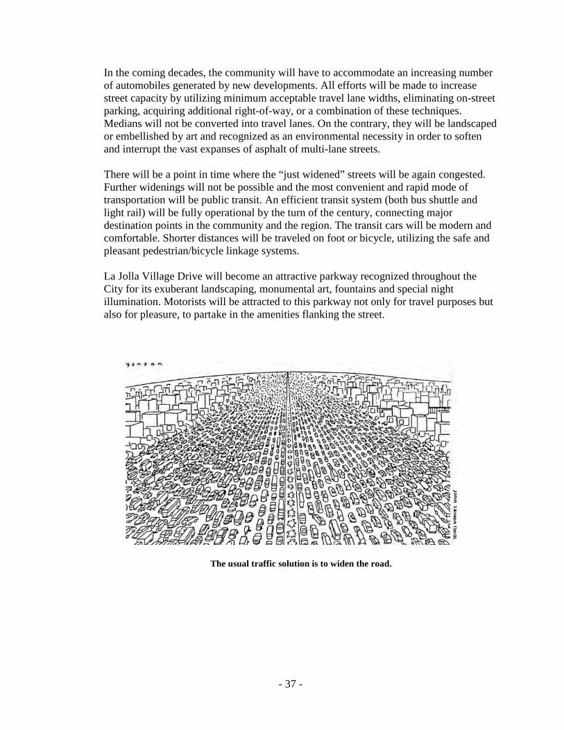
In the coming decades, the community will have to accommodate an increasing number of automobiles generated by new developments. All efforts will be made to increase street capacity by utilizing minimum acceptable travel lane widths, eliminating on-street parking, acquiring additional right-of-way, or a combination of these techniques. Medians will not be converted into travel lanes. On the contrary, they will be landscaped or embellished by art and recognized as an environmental necessity in order to soften and interrupt the vast expanses of asphalt of multi-lane streets. There will be a point in time where the “just widened” streets will be again congested. Further widenings will not be possible and the most convenient and rapid mode of transportation will be public transit. An efficient transit system (both bus shuttle and light rail) will be fully operational by the turn of the century, connecting major destination points in the community and the region. The transit cars will be modern and comfortable. Shorter distances will be traveled on foot or bicycle, utilizing the safe and pleasant pedestrian/bicycle linkage systems. La Jolla Village Drive will become an attractive parkway recognized throughout the City for its exuberant landscaping, monumental art, fountains and special night illumination. Motorists will be attracted to this parkway not only for travel purposes but also for pleasure, to partake in the amenities flanking the street.
The usual traffic solution is to widen the road.
- 38 -
D. Subareas The character of the community’s four subareas will be pronouncedly different as reflected by the urban form, landscape, buildings and people. Distinct images for these subareas should be recognized as an attribute, with transportation and open space linkages providing community cohesiveness. The Torrey Pines subarea will be the most spacious, with low-scale buildings set in a space dominated by the natural landscape. Contemporary buildings will coexist with the somewhat rural feeling exemplified by the eucalyptus-lined North Torrey Pines Road. This subarea will be considered an example of sensitive development with respect to natural topography and vegetation. Roads lined by Torrey Pines and eucalyptus trees will be the theme of this subarea. Here, there will be ample opportunities for public appreciation of panoramic vistas of Sorrento Valley, the coastal bluffs and ocean. Public paths will provide multi-modal access to such natural resources. Internationally known institutions will make this area a visitor and business destination in the San Diego region. Except for the existing University buildings, the subarea will contain predominantly low-rise buildings as prescribed by Proposition “0” which limits building height to 30 feet west of I-5. The Central subarea, as the name implies, will be the most urban subarea characterized by intense, multi-use urban development. It will also be one of the major residential, commercial and office nodes in the City. The bold, contemporary high-rise residential, commercial and office structures of the Golden Triangle will continue to provide strong identity for the community. The Golden Triangle will be known for the spacious and convenient commercial facilities that have become associated with the Southern California lifestyle. “Variety without chaos” will be the theme for the Central subarea. A variety of building types, shapes, sizes, colors and materials will be sited in the already established superblock development pattern. The Golden Triangle skyline, with its contrasting visual qualities, will become a landmark in the region. As the Central subarea builds out, its pedestrian orientation will intensify due to the high-density and multi-use nature of development, the presence of University student housing and most importantly because of the proximity of housing adjacent to the Towne Centre. The Miramar subarea will remain affected by the overflight impacts of MCAS Miramar. Its visual character will be dominated by open spaces with restricted industrial development. The South University subarea will continue to be a homogeneous, single-family residential neighborhood which draws its distinct identity from Rose Canyon to its north and San Clemente Canyon (Marian Bear Memorial Park) to its south. This identity will be further enhanced by the Regents Road bridge spanning across Rose Canyon. This “greenery” bridge will have landscaping cascading from the side railings blending with the natural beauty of the canyon.

- 39 -
As the San Diego region grows, the South University subarea will be an attractively located, family-oriented neighborhood with typical suburban characteristics. SUMMARY In conclusion, the vision for the future University community describes the underlying feeling, character and features that create community identity. It is expected that the vision described will generate a variety of urban design solutions. The important message, however, is that all development decisions reinforce the expressed image and goals for the community and pursue a vision of what the University community can become.

- 40 -
THIS PAGE INTENTIONALLY LEFT BLANK.
- 41 -
Overall Urban Design Goals

- 42 -

- 43 -
II. UNIVERSITY COMMUNITY: OVERALL URBAN DESIGN GOALS
• Improve accessibility and use relationships within the community by establishing well-defined, multi-modal linkage systems.
• Establish standards which give physical design direction to private developments
and public improvements. • Provide for the needs of pedestrians in all future design and development decisions. • Ensure that San Diego’s climate and the community’s unique topography and
vegetation influence the planning and design of new projects. • Ensure that every new development contributes to the public realm and street
livability by providing visual amenities and a sense of place.

- 44 -
THIS PAGE INTENTIONALLY LEFT BLANK.

- 45 -
Linkages

- 46 -

- 47 -
III. LINKAGES A. AUTO TRAFFIC
1. Background
Street capacity and acceptable levels of service for automobile traffic have been subjects of high priority since the beginning of this community’s development. The University community is a prototype of planning, development and lifestyle centered around the automobile. Under present attitudes towards development, auto accommodation is expected to continue to dominate design decisions in the area.
2. Issues
The basic auto-related issue revolves around the accommodation of projected traffic resulting from existing and new growth without destroying the livability of the community. Much of the community’s character has been established by the multi-lane roads which traverse it. The street widenings proposed in the adopted Plan are likely to intensify the adverse impact of large expanses of asphalt.
The community’s character has already been adversely affected by multi-lane roads.
Other street issues relate to the importance of street landscaping and the potential role of La Jolla Village Drive and Genesee Avenue as unifying urban design elements. The following summaries amplify the nature of the urban design issues pertaining to auto linkages.
- 48 -
a. Street Widenings
The necessary width, alignment and design speed of a street is related to its functional classification. The City’s Street Design Manual provides information and guidance to both City staff and professionals in the private sector responsible for the design of the City’s streets. Traffic related issues are very difficult to resolve due to wide ideological differences on the subject. City policy, reflected in the adopted Plan includes the provision of multi-modal transportation systems (auto, transit, bicycle and pedestrian) with an emphasis on the automobile. The Plan proposes controls on development intensity as a means of reducing traffic generation, however, a number of street improvements (i.e., widenings) were also recommended and adopted as a part of the Plan update. Citywide ongoing traffic management studies and improved traffic control devices should also improve the traffic situation. Following is a detailed analysis of each major proposed street widening included in the 1987 community plan. A master street improvements plan detailing landscaping and widening proposals should be prepared for all the street sections which follow. Such master plans should be funded by the Facilities Benefit Assessment (FBA) program. The analysis format includes: • Street section to be widened (see Figure 8). • Cross reference with the North University City Public Facilities Financing
Plan and Facilities Benefit Assessment Program. • Street classification type. • Description of existing and proposed improvements. • Urban design impact.
• Mitigation(s).

- 49 -
Figure 8. Proposed Street Widenings
- 50 -
GENESEE AVENUE Section A: Genesee Avenue: North Torrey Pines Road to I-5 (see Figure 8) Street Classification: Six-lane primary arterial Description of Existing/Proposed Improvements: This portion of Genesee is currently four-lanes with an 18-foot median. Steep topography characterizes both the north and south sides of the street. The widening is proposed to be accomplished within the existing right-of-way by narrowing the median to six feet. The components of this widening are to include: a. A landscaped median (eight feet minimum width). b. Contiguous sidewalks on the north side only. c. Class II bike lanes in both directions. d. No on-street parking. Impact: Although widening within the right-of-way and the provision of a sidewalk on only one side causes little or no impact to the existing topography, the provision of a six-lane facility instead of the existing four-lane facility may preclude the landscaping of the median. (A minimum width of eight feet is needed to accommodate landscaping.) Median landscaping, however, would enhance the natural wooded character of the area and the entrance to the Torrey Pines area. Mitigation(s): Given the topographical constraints of this road section, avoidance of this impact could be achieved by taking one foot from each side of the roadway to increase the median width to eight feet, thus enabling landscaping to be provided. This mitigation measure is strongly recommended. Section B: Genesee Avenue: I-5 to Regents Road (see Figure 8) Street Classification: Six-lane primary arterial with dual left-turn lanes Description of Existing/Proposed Improvements: This portion of Genesee is a four-lane facility with an 18-foot median. The widening to six-lanes and construction of dual left-turn lanes are proposed to be located within the existing right-of-way by narrowing the median and removing existing on-street parking. The proposal calls for closing mid-block median breaks. Design components of the proposed widening are to include: a. A landscaped median (eight feet minimum width). b. Contiguous sidewalks.

- 51 -
c. Provision of Class II bike lanes in both directions. d. No on-street parking. e. Retention of existing pine trees along Genesee Avenue. Impact: The widening of this portion of Genesee and construction of dual left-turn lanes will require the narrowing of the median to a width unsuitable for landscaping and removal of on-street parking. There is not enough space for both the additional proposed lanes and a desired landscaped median. Mitigation(s): It is recommended that a landscaped median be provided. Increased capacity should be achieved by narrowing travel lanes and removing on-street parking. Section C: Genesee Avenue: Regents Road to Nobel Drive (see Figure 8) Street Classification: Six-lane major with dual left-turn lanes Description of Existing/Proposed Improvements: This portion of Genesee includes both four and six-lane sections with some parking and an 18-foot median. Improvements proposed include completion of the widening to a six-lane major and dual left-turn lanes. Design components are the same as those included in Section B (I-5 to Regents Road). Impact: Same as Section B Mitigation(s): It is recommended that the existing medians south of Eastgate Mall (where six lanes are provided) be landscaped. Also the pine trees along Genesee Avenue, north of Eastgate Mall, should be retained where possible. Section D: Genesee Avenue: Nobel Drive to State Route 52 (see Figure 4) Street Classification: Six-lane major between Nobel Drive Street and Decoro Street. Six-lane primary arterial south of Decoro Street. Description of Existing/Proposed Improvements: This portion of Genesee is currently a four-lane facility with an 18-foot median. The 1987 community plan proposes widening to a six-lane primary arterial. The widening of this part of Genesee is proposed to be accomplished within the existing right-of-way by narrowing the median. Components of this widening are to include: a. A median of at least eight feet in width. b. Retention of existing contiguous sidewalks.
- 52 -
c. Class II bike lanes in both directions. d. No parking. Impact: The widening of this portion of Genesee will require the narrowing of the 18-foot medians, portions of which are currently landscaped. Mitigation(s): Widening is to be accomplished while maintaining a landscaped median. REGENTS ROAD Section A: Regents Road: Executive Drive to Governor Drive (see Figure 8) Street Classification: Four-lane major Description of Existing/Proposed Improvements: The Financing Plan includes the bridging of Rose Canyon to connect North and South University City. Components of these improvements are to include: a. Landscaping of medians including the median in Regents Road south of Nobel Drive.
Median landscaping costs should be included in the North University City Public Facilities Financing Plan and Facilities Benefit Assessment.
b. Contiguous sidewalks except on portion between Executive Drive and Nobel Drive
(Urban Node) which should have non-contiguous sidewalks with landscaped parkways. c. Class II bike lanes in both directions. d. The bridge spanning Rose Canyon should include landscaping cascading down the sides
to continue the vegetated character of the site. Impact: None identified. Mitigation(s): None identified. Section B: Regents Road: Genesee Avenue to Executive Drive (see Figure 8) Street Classification: Four-lane major Description of Existing/Proposed Improvements: The Financing Plan provides for the widening of Regents Road between Genesee Avenue and Executive Drive from two lanes to four lanes. This part of Regents Road is adjacent to the UCSD campus and La Jolla Country Day School. Components of this widening are to include:
- 53 -
a. Non-contiguous sidewalks with landscaped parkways. b. Relocation and reuse of existing trees bordering Regents Road if feasible. c. Class II bike lanes in both directions. d. No parking. Impact: The widening of Regents Road between Genesee Avenue and Executive Drive will require the removal of the existing trees along the edges of the street. Mitigation(s): The pine trees are to be retained with sidewalks provided behind them thereby providing a boulevard quality and an inviting pedestrian entrance to the east campus. NOBEL DRIVE Section A: Nobel Drive: I-5 overcrossing (see Figure 8) Street Classification: Four-lane primary arterial/half-diamond interchange to and from the south Description of Existing/Proposed Improvements: The bridge over I-5 is currently a two-lane facility. The bridge is proposed to be widened to four lanes with dual left-turn lanes and sidewalks and Class II bike lanes in each direction. This overcrossing will become an important link connecting the two community cores. Landscaping within Caltrans right-of-way will be included as part of this project. Impact: None identified. Mitigation(s): None identified. Section B: Nobel Drive: Lebanon Drive to Regents Road (see Figure 8) Street Classification: Six-lane major Description of Existing/Proposed Improvements: This section of Nobel Drive was originally planned as a four-lane primary arterial. However, during the 1987 plan update it was determined that a six-lane facility was needed. Development along this portion of Nobel Drive is either approved or built and most of the street has already been widened to six lanes. The section of Nobel on the north side and just west of Regents Road is yet to be widened. The widening project should include generous street edge re-landscaping to help buffer adjacent residential units from street noise and pollution and traffic lanes of minimum, safe width. At the I-5 crossing, the travel lanes at each end of the spanning structure must
- 54 -
facilitate and direct the movement of bicycles and pedestrians into the freeway-fronting developments. Other components of this widening are to include: a. Non-contiguous sidewalks with street trees to match the existing ones to the west. b. Class II bike lanes. c. No parking. Landscaped median (eight feet minimum width). d. Landscaped median (eight feet minimum width). e. Existing mature trees should be moved and transplanted elsewhere. Impact: This widening as described above will result in noise, air and visual negative impacts to abutting residential projects between Danica Mae and Regents Road. Removal of existing mature trees will be required. Mitigation(s): Widening is to be accomplished by narrowing lane widths in order to reduce impact to abutting residential areas. Street edges should be re-landscaped with the cost of such re-landscaping financed by the Facilities Benefit Assessment (FBA) Program as part of the total widening project. If possible, existing mature trees should be transplanted within the public right-of-way. Section C: Nobel Drive: Genesee Avenue to Towne Centre Drive (see Figure 8) Street Classification: Six-lane primary arterial Description of Existing/Proposed Improvements: Between Genesee and Towne Centre Drive the existing street design includes four lanes with contiguous sidewalks and a 14-foot landscaped median. The proposed widening is to be accomplished within the existing right-of-way by prohibiting parking. The design of this project is to include: a. Retention of the landscaped median. b. Retrofitting with non-contiguous sidewalks with landscaped parkways. c. Class II bike lanes. d. No parking. e. No additional widening of the roadway. Impact: None identified. Mitigation(s): None identified.

- 55 -
Section D: Nobel Drive: Towne Centre Drive to I-805/Interchange (see Figure 8) Street Classification: Six-lane primary arterial Description of Existing/Proposed Improvements: Currently, only a half-width portion of Nobel Drive east of Towne Centre Drive has been constructed. The segment of Nobel between Towne Centre Drive and I-805 will be a six-lane primary arterial. The design of this project should include: a. Landscaped median (eight feet minimum width). b. Non-contiguous sidewalks with landscaped parkways. c. Class II bike lanes in both directions. d. No parking. e. Landscaping of interchange right-of-way. Impact: None identified. Mitigation(s): None identified. Section E: Nobel Drive: I-805 to Miramar Road (see Figure 8) Street Classification: Four-lane major Description of Existing/Proposed Improvements: This portion of Nobel Drive does not currently exist. It is proposed to be built as a four-lane major and should be designed to include the following: a. Landscaped median (eight feet minimum width). b. Non-contiguous sidewalks with landscaped parkways. c. Class II bike lanes in both directions. d. No parking. Impact: None identified. Mitigation(s): None identified.

- 56 -
JUDICIAL DRIVE Section A: Judicial Drive: Eastgate Mall to Nobel Drive (see Figure 8) Street Classification: Four-lane major Description of Existing/Proposed Improvements: Judicial Drive is proposed to be constructed as a four-lane major street. Design of this road should include: a. Landscaped (eight feet minimum width). b. Non-contiguous sidewalks with landscaped parkways. c. Class II bike lanes. d. No parking. Impact: None identified. Mitigation(s): None identified. TOWNE CENTRE DRIVE Section A: Towne Centre Drive: Golden Haven to Eastgate Mall (see Figure 8) Street Classification: Four-lane major Description of Existing/Proposed Improvements: Towne Centre Drive is a four-lane facility which is almost complete. Non-contiguous sidewalks with landscaped parkways should be provided. Medians should be landscaped if feasible. No parking should be permitted. Impact: None identified. Mitigation(s): None identified. EXECUTIVE DRIVE Section A: Executive Drive: Golden Haven to Eastgate Mall (see Figure 8) Street Classification: Four-lane collector and LRT route.

- 57 -
Description of Existing/Proposed Improvements: Portions of Executive Drive are built while some are under construction or unbuilt. The Chancellor Park and Nexus projects have provided non-contiguous sidewalks with landscaped parkways. This pattern should be continued in the future as Executive Drive is completed. Additional right-of-way for light rail transit will need to be provided by projects along this road. Impact: None identified. Mitigation(s): None identified. Section B: Executive Drive: Towne Centre Drive to Judicial Drive (see Figure 8) Street Classification: Four-lane collector and LRT route Description of Existing/Proposed Improvements: This street is currently under construction. Sidewalks along this street should be non-contiguous. Parkways should be planted with palm trees to match existing development. Impact: None identified. Mitigation(s): None identified. NORTH TORREY PINES ROAD Section A: North Torrey Pines Road: Genesee Avenue to north boundary of Torrey Pines Science Park (see Figure 8) Street Classification: Six-lane primary arterial; five-lane major north of Callan Road (two lanes on west side) Description of Existing/Proposed Improvements: Portions of this road have already been widened to six-lanes. The remaining widening and improvements along North Torrey Pines should include: a. Retention of, and additional median landscaping. b. Provision of non-contiguous sidewalks with landscaped parkways on both east and west
sides south of Science Park Road adjacent to Gentry Property. c. Class II bike lanes. d. No parking. e. Bridge should include sidewalks and bike lanes.
- 58 -
Impact: The widening of North Torrey Pines Road will result in the removal of mature Eucalyptus trees adjacent to and northerly of the Sheraton Hotel. The quaint, existing road (and bridge) with its rural character will also disappear. Mitigation (s): It is recommended to retain the existing five-lane North Torrey Pines Road north of the Callan Road bridge where development intensities are lower. This would allow the preservation of the existing Eucalyptus trees and attractive road image. LA JOLLA VILLAGE DRIVE Section A: La Jolla Village Drive: Villa La Jolla Drive to I-5 (see Figure 8) Street Classification: Six-lane primary arterial with an eight-lane section from Villa La Jolla Drive to I-5. Description of Existing/Proposed Improvements: La Jolla Village Drive is characterized by contiguous five-foot sidewalks and sporadic landscaped medians. Much of the widening of this road is in progress or has already been completed. No bicycle lanes are planned for this road. Impact: The already accomplished widening of the majority of La Jolla Village Drive has created a freeway effect through the community. The additional widening to eight lanes west of I-5 will decrease the existing median width and require additional right-of-way, possibly resulting in the reduction of landscaping on this road. Mitigation (s): Landscaping on medians and street edges, and special nighttime illumination as discussed later in this Urban Design element. Section B: La Jolla Village Drive: Judicial Drive to I-805 (see Figure 8) Street Classification: Eight-lane primary. Description of Existing/Proposed Improvements: This portion of La Jolla Village Drive is proposed to be widened to eight lanes by reducing the median and acquiring additional right-of-way Impact: The existing landscaped median and part of the landscaping on the northern edge of the Gateway Project would be eliminated to accommodate this widening. Mitigation (s): It is recommended to widen La Jolla Village Drive east of Judicial Drive only in order to preserve the existing landscaping adjacent to the Gateway office project.
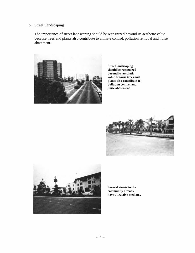
- 59 -
b. Street Landscaping
The importance of street landscaping should be recognized beyond its aesthetic value because trees and plants also contribute to climate control, pollution removal and noise abatement.
Street landscaping should be recognized beyond its aesthetic value because trees and plants also contribute to pollution control and noise abatement. Several streets in the community already have attractive medians.
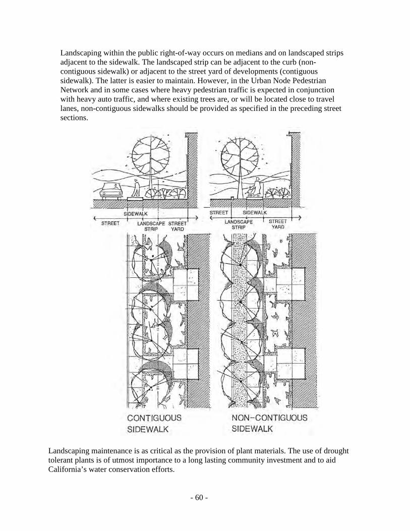
- 60 -
Landscaping within the public right-of-way occurs on medians and on landscaped strips adjacent to the sidewalk. The landscaped strip can be adjacent to the curb (non-contiguous sidewalk) or adjacent to the street yard of developments (contiguous sidewalk). The latter is easier to maintain. However, in the Urban Node Pedestrian Network and in some cases where heavy pedestrian traffic is expected in conjunction with heavy auto traffic, and where existing trees are, or will be located close to travel lanes, non-contiguous sidewalks should be provided as specified in the preceding street sections.
Landscaping maintenance is as critical as the provision of plant materials. The use of drought tolerant plants is of utmost importance to a long lasting community investment and to aid California’s water conservation efforts.

- 61 -
The wider the street the greater the need for landscaped medians to break the vast expanses of asphalt.
Although amenities have been provided, they are not in locations of high street visibility.

- 62 -
c. La Jolla Village Drive/Genesee Avenue
These major arterials have yet to reach their potential as major unifying corridors and identity elements in the community. La Jolla Village Drive and Genesee Avenue connect key activity centers and provide primary access to freeways. The most notable developments in the community abut these roads. However, because of their introverted site and building design, these developments do not contribute to street livability. Although amenities (fountains, courtyards, art works) have been provided within many projects, they are not in locations of high visibility from the street. Communities are usually judged by the attractiveness and quality of their public areas (streets and collective image created by exteriors of developments). Notable community streets such as La Jolla Village Drive and Genesee Avenue fail to generate the unity and continuity necessary to sustain a “planned community” image. Relatively minor improvements such as an increased level of right-of-way landscaping, consistent landscaping elements within private street yards and special night illumination would greatly improve the character of these primary arterials, and therefore strengthen community image.
Current image of La Jolla Village Drive

- 63 -
3. Recommendations – Auto Traffic
The recommendations which follow consists of two parts: OBJECTIVE, and ACCOMPLISHED BY. OBJECTIVE: Create full awareness of the environmental consequences of the proposed street widening included in the adopted 1987 Plan. ACCOMPLISHED BY: • Reevaluating priorities and recognizing that the short-term conveniences afforded by
adding auto traffic capacity will negatively affect the quality and livability of the University community in the long term.
• Investing in generous street landscaping to mitigate the negative impacts of too much
concrete. Landscaping improvements in street rights-of-way should comply with the City of San Diego’s Landscape Technical Manual.
• Finding alternative engineering solutions for street space design within the existing
right-of-way. • Amplifying the objectives of the Facilities Benefit Assessment (FBA) program so that
FBA funds previously allocated to street widenings can be diverted to transit improvements.
OBJECTIVE:
Provide a landscaped median in all roads having six lanes and over. Consider pavement and other low-rise, unobtrusive art treatments as supplements or alternatives to landscaping. For example: thinking of medians as mediums for art. ACCOMPLISHED BY: • Utilizing landscaping materials that are drought resistant and easy to maintain.
Desirable plant materials include trees and accent plants. Ground cover plantings should be kept to a minimum and no turf should be included anywhere. Tree specimen selection, location and spacing must be approved by the City’s Park and Recreation Department. Other desirable surface cover includes decorator bark, brickwork, tiles, etc.
• Establishing developer responsibility for providing median landscaping/art treatment
as a condition of development permit or plan amendment approval. Developers

- 64 -
should be required to provide and maintain such median landscaping/art treatment, and participate in a Landscape Maintenance District.
• Retrofitting existing medians with landscaping/art treatment as part of community
sponsored projects and/or surplus Facilities Benefit Assessment (FBA) funds. • Forming a community-wide Landscape Maintenance District for the purpose of
maintaining existing and new median landscaping throughout the community. OBJECTIVE: Reinforce the roles of La Jolla Village Drive and Genesee Avenue serving as unifying urban design elements and orientation resources in the community. ACCOMPLISHED BY: • Ensuring median landscaping on these streets. • Illuminating landscaping (both edges and medians) and abutting buildings to create
night identity and ambiance. Directed spot flood lighting should be on private property or attached to street trees or light poles at an elevation inaccessible to pedestrians.
• Introducing directional road signs pointing to the location of public parks and visitor-
oriented facilities within and adjacent to the community. • Including additional landscaping, illumination and directional signage costs in the
Facilities Benefit Assessment (FBA) program for the community, or establishing an assessment district for such purpose.
• Preparing a precise design and implementation plan for the embellishment of La Jolla
Village Drive and Genesee Avenue. • Forming a community-wide assessment district for the purpose of maintaining
median landscaping throughout the community.
- 65 -
OBJECTIVE: Ensure that the street yards of private developments bordering La Jolla Village Drive and Genesee Avenue support the desired image and monumental quality of these roads. ACCOMPLISHED BY: • Maximizing landscaping investments by using drought tolerant plants. The Landscape
Technical Manual for the City of San Diego includes reference materials for water conserving plants. Developers and designers should use this manual as an aid for selecting plant materials for design projects.
• Planting mature street yard trees at consistent intervals for maximum impact. Within
the chosen theme for each project, landscaping should conform to the City’s Landscape Ordinance at the minimum.
• Locating private property art works and other amenities so that they are visible and
accessible from La Jolla Village Drive and Genesee Avenue. • Distinguishing the intersections of La Jolla Village Drive/Torrey Pines Road, La Jolla
Village Drive/Regents Road, La Jolla Village Drive/Genesee Avenue, La Jolla Village Drive/Towne Centre Drive, La Jolla Village Drive/I-805, Genesee Avenue/North Torrey Pines Road, Genesee Avenue/Regents Road, Genesee Avenue/Nobel Drive, and Genesee Avenue/Governor Drive through the use of special treatments within private property (see Figure 9). Special treatments may simply consist of formal landscaping or may be more elaborate and include public art, fountains, ornamental lighting, decorative paving materials at the intersection corners, and street furniture. These amenities should, however, be located so as not to interfere with the vision and safety of motorists. Precise locations and treatments should be reviewed by the City Engineer and the Planning Director at the time of implementation.
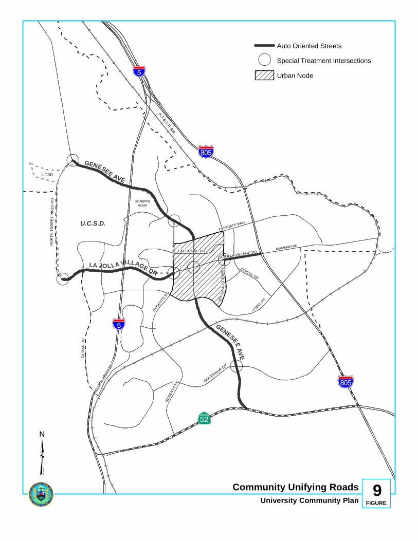
(
(
(
( ((
(
!"̂$
!"̂$
%&s(
?nE
SCRIPPSHOSP
UCSD
PACI
FIC O
CEAN
A.T.& S.F. RRNOBEL D
R
EASTGATE MALL
MIRAMAR RD
U.C.S.D.
JUDICIAL DR
TOWNE CE NTREDR
LA JOLLA VILLAGE DR
GENESEEAVEGENESEE AVE
%&s(
GILM
AN D
R
LA JOLLA VILLAGE DR
REGE
NTS R
D GOVERNOR DR
NORT
H TO
RREY
PINE
S RD
LA JO
LLA C
OLON
Y DR
EXECUTIVE DR
REGENTS RD
Community Unifying RoadsUniversity Community Plan 9
FIGURE
Auto Oriented Streets
( Special Treatment IntersectionsUrban Node
³

- 67 -
• Developing a Master Plan for public art in the University community. A useful first step would be to inventory site opportunities for discussion with the City’s Commission for Arts and Culture and the Office of the City Architect. Involve lots of people to avoid responding only to one set of expectations.
• Establishing a “Percent for Art” program in the University community. Such a
program should consist of developer contributions amounting to one percent or more of the total construction cost of a project. Such contributions should be deposited in a trust fund and supplemented by voluntary donations of money or art works by private developers. The “Percent for Art” program should be administered by the Office of the City Architect.
• Requiring all new developments (except single-family residential), infills, additions
and plan amendments abutting La Jolla Village Drive and Genesee Avenue to provide artworks or contribute to an Art Fund under the above recommended “Percent for Art” program to be used for financing art works. Developers should be allowed to provide on-site artworks, donate their share to the trust fund or do both.
Art works should not be limited to objects within a space intended for close-up contemplation. Art works can be a landscape, or a building element as a piece of sculpture, or the treatment of any surface. Exterior art may be useful as well, including places to sit, play and touch. When deciding on a work of art, lighting design, environmental design, sculptural design and architectural treatments should be considered. Functional, aesthetic and utilitarian art are all appropriate. Preferably, exterior art should be integrated into the fabric of a development and not be an “afterthought.” Within this context the provision of art integrated into development plans is likely to require collaboration among a broad range of design professions (i.e., architects, artists, landscape architects, planners, urban designers, etc.), and participation from the City’s Commission for Arts and Culture and the Office of the City Architect.

- 68 -
B. PEDESTRIAN WAYS
1. Background
A majority of streets in the University community are presently inhospitable to pedestrian activity. Auto convenience has dictated development standards and decisions often at the expense of pedestrians, bicyclists and transit riders. With increasing urbanization and concern with the environment and quality of life, it is imperative to address the needs of pedestrians not only with respect to access, but to ensure safety, comfort and amenities. Pedestrian considerations are especially important in the vicinity of the campus and housing areas adjacent to commercial areas.
2. Issues
The University community offers major design challenges with respect to the needs of pedestrians. The following have been identified as major issues which provide the basis for the objectives and recommendations included in this section of the Urban Design Element.
a. Ground Level Treatments
The ground level is closest to view and touch and provides opportunities for entrances. Its character is most critical with respect to people experiences on foot or vehicle in both urban and suburban areas. Some University community developments already recognize this and have, or will include, street level architectural details, varied materials, landscaped, usable spaces, artworks and other eye level amenities. Generally, however, the ground level experience in the community should be further enhanced particularly within the urban node, which is shown in Figure 12.
Few developments provide pedestrian activities oriented to the street.
Most projects within the intensely developed urban node do not contribute to street livability.

- 69 -
b. On-site Parking
Generally, on-site parking requirements tend to discourage the use of street sidewalks. The traditional practice of providing parking on the same site of the development it serves destroys sidewalk activity since pedestrian movements are primarily vertical and internal between underground parking areas and the buildings within the superblocks.
It is common practice and usually a City requirement to provide parking on the same development it serves which tends to discourage use of sidewalks.
Through site design techniques and amenity awareness, pedestrian flow could be channeled from on-site parking areas to the designated pedestrian network, thereby contributing to the creation of outdoor pedestrian activity and vitality desired in the central community.
c. Superblock Development
Superblocks offer unusual development opportunities but also pose problems such as excessive walking distances between activity nodes, difficulties in finding destination points within the large complexes and lack of a cohesive identity in the case of multi-unit developments. Furthermore, the internally-oriented superblocks bounded by overly wide streets have an intimidating effect on pedestrians. Within the established superblock pattern, pedestrian amenities are usually located in the central areas of projects serving the users of such projects. There is little or no interaction between the superblocks and few connections provided between superblocks and the public right-of-way. Typically, people find it easier and safer to drive from superblock to superblock, compounding traffic congestion.

- 70 -
Wide streets are intimidating to pedestrians.
d. Siting and Orientation of Buildings
Many developments turn their backs to the street or are “barricaded” from the street by bermed landscaping and parking structures or lots. Large setbacks are desirable in residential areas for privacy and to protect from noise and pollution. They have the opposite effect, however, in nonresidential areas by creating the illusion of additional street width which is uncomfortable to pedestrians. Street livability is usually achieved by locating buildings at or near the property line enclosing and containing space within the street corridor.
Nonresidential projects are “barricaded” from the street by bermed landscaping discouraging spontaneous access by pedestrians.
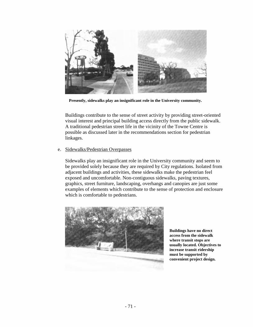
- 71 -
Presently, sidewalks play an insignificant role in the University community.
Buildings contribute to the sense of street activity by providing street-oriented visual interest and principal building access directly from the public sidewalk. A traditional pedestrian street life in the vicinity of the Towne Centre is possible as discussed later in the recommendations section for pedestrian linkages.
e. Sidewalks/Pedestrian Overpasses
Sidewalks play an insignificant role in the University community and seem to be provided solely because they are required by City regulations. Isolated from adjacent buildings and activities, these sidewalks make the pedestrian feel exposed and uncomfortable. Non-contiguous sidewalks, paving textures, graphics, street furniture, landscaping, overhangs and canopies are just some examples of elements which contribute to the sense of protection and enclosure which is comfortable to pedestrians.
Buildings have no direct access from the sidewalk where transit stops are usually located. Objectives to increase transit ridership must be supported by convenient project design.

- 72 -
With the exception of the pedestrian overpass linking the University Towne Centre and “The Plaza” project, existing overpasses seem to go from nowhere to nowhere. They solely provide a safe means of crossing wide streets. The connection from the overpass to the sidewalk is often a long winding ramp, stairs or elevator, and are perceived as inherently inconvenient by most pedestrians when grade or upper level crossing is possible. Design solutions must address the needs of the handicapped while contributing to the aesthetic quality of the community.
Good example of landing area at the end of a pedestrian overpass.
Free-standing overpasses should be avoided.
The existing overpasses themselves are, for the most part, uninviting and sterile. Access to them is in some cases too enclosed and invisible to be considered safe.
Uninviting chain links are commonly found in the community.
Access to overpass is too enclosed for comfort and safety.

- 73 -
3. Recommendations - Pedestrian Linkages
The recommendations which follow consist of two parts: OBJECTIVE, and ACCOMPLISHED BY.
OBJECTIVE: Designate and clearly define a primary pedestrian network linking superblocks, major activity centers and resource areas utilizing the public sidewalk, street level crossings, overpasses, meandering paths through private developments and trails through natural open space areas. The proposed alignment of this primary pedestrian network is shown in Figure 10; however, pedestrian linkages are not limited to this proposal. The primary pedestrian network should be supplemented by internal paths within the superblocks. ACCOMPLISHED BY: • Painting a color line or symbol on the sidewalk pavement, as well as providing
directional signage. • Ensuring that the urban node pedestrian network sidewalks have generously
landscaped parkways, are non-contiguous and have a minimum of six feet in width. Existing contiguous sidewalks should be retrofitted as part of infill developments discussed later in this Urban Design Element.
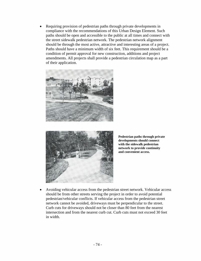
- 74 -
• Requiring provision of pedestrian paths through private developments in compliance with the recommendations of this Urban Design Element. Such paths should be open and accessible to the public at all times and connect with the street sidewalk pedestrian network. The pedestrian network alignment should be through the most active, attractive and interesting areas of a project. Paths should have a minimum width of six feet. This requirement should be a condition of permit approval for new construction, additions and project amendments. All projects shall provide a pedestrian circulation map as a part of their application.
Pedestrian paths through private developments should connect with the sidewalk pedestrian network to provide continuity and convenient access.
• Avoiding vehicular access from the pedestrian street network. Vehicular access should be from other streets serving the project in order to avoid potential pedestrian/vehicular conflicts. If vehicular access from the pedestrian street network cannot be avoided, driveways must be perpendicular to the street. Curb cuts for driveways should not be closer than 80 feet from the nearest intersection and from the nearest curb cut. Curb cuts must not exceed 30 feet
in width.
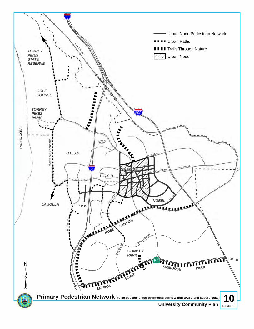
!"̂$
!"̂$
%&s(
?nE
SCRIPPSHOSP
UCSD
PACI
FIC O
CEAN
A.T.& S.F. RRNOBEL D
R
EASTGATE MALL
MIRAMAR RD
E
E
TORREYPINESSTATERESERVE
GOLFCOURSE
TORREYPINESPARK
U.C.S.D.
U.C.S.D.
LVJS
STANLEYPARK
LA JOLLA
ROSE CANYON
MARIONBEAR
MEMORIAL PARK
NOBEL
SORRENTO VALLEY
UTC
GENESEE AV
GILM
AN D
R
LA JOLLA VILLAGE DR
REGE
NTS R
D GOVERNOR DR
NORT
H TO
RREY
PIN
ES R
D
LA JO
LLA C
OLONY
DR
EXECUTIVE DR
REGENTS
RD
Primary Pedestrian NetworkUniversity Community Plan 10
FIGURE
Urban Node Pedestrian NetworkUrban PathsTrails Through NatureUrban Node
³(to be supplemented by internal paths within UCSD and superblocks)
- 76 -
• Financing the retrofitting of existing sidewalks, new directional signage and color line or symbols as a condition of development permit approval, surplus Facilities Benefit Assessment (FBA) funds, and/or the City’s Capital Improvements Program (CIP).
OBJECTIVE: Ensure that the location of new pedestrian overpasses and street level crossings reinforce the pedestrian network and that their design reflects safety, uniqueness and community pride. ACCOMPLISHED BY:
. • Designing overpasses as integral parts of projects not as “afterthoughts.”
Overpasses should connect buildings, plazas, existing and planned transit facilities, major entrances and the most active and interesting areas on both sides of the street at the same level, or upper level. Detached and isolated overpasses landing on parking lots or dead spaces should be avoided. Overpass design plans should be required as a condition of new development or plan amendment permit approval. Retrofitting of existing overpasses may also be required as a condition of above mentioned permit approvals.
• Designing overpasses as one-of-a-kind landmarks which can create identity
and citywide interest. Overpasses should be places for art as well as pieces of art. The walking path and side enclosures offer imaginative opportunities for artistic design. The side enclosures of an overpass should maximize views, pedestrian comfort and security. The solid portion of side enclosures must maintain a feeling of openness. Utilitarian, chain link enclosures should be avoided unless enhanced by climbing plant materials. Overpass access which is enclosed or hidden from public view should also be avoided.
All proposals for new overpasses must submit the following in conjunction with new development or plan/project amendment permit applications:
• Proposed theme, color, materials, textures, landscaping, artworks and other
unique features. • Description of land uses, structures and activities at landing points on each side
of the overpass. • Proposed access design from private property as well as from the public
sidewalk.

- 77 -
• Installing intersection and mid-block street level crossing alert devices at those
points identified in Figure 11 in order to ensure pedestrian network continuity. The curb at such crossing points should allow use by handicapped persons. Such devices may consist of caution signs, lights, painted walks, on-street parking restrictions around the marked crossing, roadway materials that cause vibrations when drivers pass over them warning to slow down and other devices as considered appropriate by the City Engineer. The use of a specific device may vary on a case-by-case basis and should be determined by the City Engineer as crosswalks are installed. Crossings should have a more intense illumination than sidewalks.
Overpasses should connect buildings, plazas and “people areas” becoming integrated parts of projects.
!
!
!
!
!
! ! !
!!
!
!
!!
!
!
!
!
!
!
!
!
!"̂$
!"̂$
%&s(
?nE
SCRIPPSHOSP
UCSD
PACI
FIC O
CEAN
A.T.& S.F. RR
NOBEL DR
EASTGATE MALL
MIRAMAR RD
U.C.S.D.
JUDICIAL DR
TOWNE CE NTREDR
LA JOLLA V ILLAGE DR
GENESEE AVE
GENESEE AVE
%&s(
E
E NOBEL PARK
UTC
NOBEL PARK
LA JOLLAVILLAGESQUARE
GILM
AN D
R
REGE
NTS R
D GOVERNOR DR
NORT
H TO
RREY
PINE
S RD
LA JO
LLA C
OLON
Y DR
EXECUTIVE DR
REGENTS RD
Pedestrian CrossingsUniversity Community Plan 11
FIGURE
PRIMARY PEDESTRIAN NETWORKOVER/UNDERPASSES
! STREET LEVEL CROSSING ALERT DEVICESURBAN NODE
³
- 79 -
Infill structures containing eating establishments, art galleries and other pedestrian-oriented activities are appropriate infill developments on existing street yards abutting the urban node pedestrian network and internal pedestrian paths within superblocks. OBJECTIVE: Retrofit development bordering the Urban Node Pedestrian Network with pedestrian-oriented uses and amenities which contribute to street vitality. ACCOMPLISHED BY: • Allowing infill development on exiting street yards and surface parking lots
bordering the Urban Node Pedestrian Network shown in Figure 10. Examples of pedestrian-oriented uses include restaurants, retail shops, hotel lobbies, cafes, cultural institutions, entertainment, etc. Examples of desired amenities include transparent walls, entrances, windows, plazas, seating, special lighting and paving, unique landscaping forms, art and water features, atriums, courtyards, etc. New infill development consistent with the guidelines of this Urban Design Element would provide economic incentives to developers in return for their contributions to the public realm and community livability.

- 80 -
• Ensuring that the new street yard infill development parallels the alignment of the adjacent pedestrian network in order to provide a sense of enclosure and maintain the street wall.
• Avoiding or screening utility boxes, mechanical equipment and other utilitarian
building components from view from the Urban Node Pedestrian Network. Similarly, service areas should not be visible from such pedestrian network.
• Requiring entrances from the public sidewalks into new infill structures
bordering the Urban Node Pedestrian Network. There should be maximum visual interest and contact with the infill building’s interior from the adjoining sidewalk.
Building height subject to visual break requirement.
• Restricting the location of new surface and above-grade parking in the Urban Node Pedestrian Network. Such parking including driveways can occupy only 30 percent of this street yard. The remaining 70 percent should be built upon and/or landscaped with soft or hard materials according to the regulations of the City’s Landscape Ordinance.
• Requiring “visual breaks” along the street yard bordering the Urban Node
Pedestrian Network. Examples of “visual breaks” include setback variations, sculpted facade treatments, changes in color, material, texture and landscaping elements, articulated walls and fences, special features and amenities.
Single treatment of an infill building wall or fence bordering the Urban Node Pedestrian Network should not exceed 50 linear feet. For example, every 50 feet the building or fence should protrude, recess, change in color or texture. Similarly, landscaping or other treatment within this street yard should not exceed 100 linear feet. For example: every 100 linear feet, the basic

- 81 -
landscaping theme should introduce a new element (form, planting material, hardscape, etc.) to break the monotony and enhance the pedestrian experience. This requirement is not intended to conflict or prohibit a uniform street tree theme along an entire street. Parks and natural open space resource areas are excluded from the “visual break” requirement. The vertical distance of a new wall bordering the Urban Node Pedestrian Network which is subject to the “visual break” requirement is 12 feet.
Examples of good pedestrian-oriented environments which already exist in the community. The Urban Design Element proposes that more of these amenities be provided. However, they should be located adjacent to the urban node pedestrian network and along the internal pedestrian paths within the superblocks.

!!
!!
!!
!!
!!
!!
!!
!!
!!
!!
!!
!!
!!
!!
!!
!!
!!
!!
!!
!!
!!
!!
! ! ! ! ! ! ! ! ! !!
!!
!!
!!
!!
! ! ! ! ! ! ! ! !
!!
!! ! ! ! ! !
!!
!
!!
! ! !
! ! !
!!!!!!!!!!!!!!!!!!!!!!!!!!!!!!!!!!!!!!!!
!!
!!
!!
!!
!!
!!
!!
!!
!!
!!
!!
!!
!!
!!
!!
!!
!!
!!
!!
!!
!
!!!!!!!!!!
!!
!!
!!
!!!!!!!!!!!!!!!!!!!!!!!!!!!!! !
!!
!!
!!
!!
!!
!!!!
! ! ! ! ! ! !
!!
!!
!!
!!
!!
!!
!!
!!
!!
!!
!!
!!
!!
!
!!
!!
!!
!!
!!
!!
!
!!
!!
!!
!!
!!
!!
!
! ! ! ! ! ! ! !
!!
!
! ! ! ! ! ! !!
!!
!! ! !
!!
!!
!!
!!
! ! !
!!
!!
!
!!!!
!!!
! ! ! !
! ! ! ! ! ! ! ! ! ! ! ! !
!!
!!
!!
!!
!!
!
!!
!!
!!
!!
!!
!!
!!
!!
!
!!
!!
!!
!!
!!
!!
!!
!!
! ! ! ! ! ! ! ! ! ! ! ! ! ! ! ! ! ! ! !!
!!
!!!
!!
!!!!!
!!
!!
!!
!!
!!
!!
!!
!!
!!
!!
!!
!!
!!
!!
!!
!!
!!
!!
!!
!!
!!
!!
!!
!!
!!
!!
!!
!!!
k
EASTGATE MALL
EXECUTIVE DR
LA JOLLA VILLAGE DRIVE
GENESEE DRIVE
NOBEL DR
TOWNE CENTER DR
REGENTS RD
EXCUTIVE WAY
Urban NodeUniversity Community Plan FIGURE
12
! ! ! PRIMARY PEDESTRIAN NETWORKPEDESTRIAN OVERPASSPARCELS

- 83 -
C. BIKEWAYS
1. Background
Bikeways are especially important in and around University campuses not only for transportation but also for recreational purposes. An expanded system of bikeways will encourage additional students to bicycle to and from campus as well as between classrooms. Bikeways are also important elements in any community and should direct riders to the major activity centers and points of interest in an area. The existing and proposed bikeway system for the University community is shown in Figure 23 in the Transportation Element of this Plan. This figure shows only the foundation for the community’s bikeway system which should be supplemented by bikeways in the interior of the superblocks. The Transportation Element also sets forth criteria for community bikeways. The City of San Diego Street Design Manual establishes uniform standards for the development of bikeways throughout the City. This Urban Design Element is concerned with the visual identity of the bike linkages, and their contribution to community cohesiveness. The majority of bikeways in the University community, as elsewhere in the City, are Class II bikeways located within the roadway directly adjacent to the outside motor vehicle lane. They are designated by signs and pavement markings. More desirable but also more difficult to implement are Class I bikeways. This bikeway type is completely separated from auto traffic within an independent right-of-way. The latter is more feasible within private developments and in recreational resource areas and parks such as Rose Canyon, Sorrento Valley, Marian Bear Memorial Park and Torrey Pines State Reserve Park. Class III bikeways are also present within the University community. Under this type, bicycle traffic shares roadway with motor vehicles. The various bikeway types are shown in Figure 24 in the Transportation Element of this Plan.
2. Issues The major issue related to bikeways is to ensure that a continuous bikeway system connects all major activity areas within the University community and facilitates access to the citywide system.
3. Recommendations - Bikeways
The recommendations which follow consists of two parts: OBJECTIVE, and ACCOMPLISHED BY.
- 84 -
OBJECTIVE:
Complete the missing links of the proposed bicycle system shown in Figure 23, and thus reaffirm the importance of bicycles as effective alternative modes of transportation in the University community. ACCOMPLISHED BY:
• Ensuring that by 1990, an efficient and continuous bicycle system links at the
very minimum the Campus, La Jolla Village Square and the University Towne Centre.
• Identifying bikeways by consistent, uniform signage and roadway markings as
discussed in the Transportation Element of this Plan under Section IV.D Item Nos. 1, 2 and 3.
• Requiring that every new development or Plan amendment request include
provisions for on-site Class I or Class II bikeways connecting with the street bikeway system shown in Figure 23. Bikeways internal to the superblock should be accessible to the public.
• Ensuring that construction of the new Nobel Drive/I-5 overpass and the
Regents Road/Rose Canyon overpass provide for Class II bikeways.
• Requiring new developments fronting the proposed bikeway system to dedicate bike lane right-of-way adjacent to the existing public right-of-way.
• Including all bikeway related costs in the Facilities Benefit Assessment (FBA)
program for the University community. D. TRANSIT
1. Background
The Transportation Element of this Plan discusses future transit route alignments and the proposals for both bus and light rail systems. This Urban Design Element is concerned with the character of development abutting the proposed LRT right-of-way as well as the functional and design components of transit stops. With respect to the latter, this element addresses two basic concepts: integrated and detached transit stations. Integrated stations usually form part of buildings, structures, public-oriented plazas of open spaces. (The existing station at the University Towne Centre is a good example of an integrated transit stop). Detached stations are usually located on or adjacent to the public street sidewalk.

- 85 -
2. Issues
Projects fronting the future transit loop face unique challenges and opportunities regarding the type and intensity of development, as well as the image and character of buildings and spaces which will be visible from the transit corridor. Most bus stops in the community consist of isolated, utilitarian benches on the sidewalk, or of a single pole holding a bus stop symbol. Neither situation provides information on routes or schedules. The proposed internal community shuttle loop, the LRT system and improved bus service present opportunities for designing efficient transit stops. The issues in this regard relate to the location, functional components and design of such stops in order to improve service and appearance and attract users.
3. Recommendations - Transit
The recommendations which follow consists of two parts: OBJECTIVE, and ACCOMPLISHED BY. OBJECTIVE:
Ensure that the proposed LRT corridor shown in Figure 22 under the Transportation Element of this Plan offers a variety of interesting views and amenities to transit riders. The transit route should maximize appreciation of the natural and man-made assets of the community.
ACCOMPLISHED BY: Requiring that developments flanking the LRT corridor locate entrances, and amenities towards the transit stations and right-of-way. At-grade park-and-ride facilities should be landscaped and if possible screened from visibility from transit riders. Park-and-ride parking structures (garages) should be designed so that the facades visible to transit riders include aesthetically pleasing treatments.
OBJECTIVE:
Ensure that retrofitted and future transit stops optimize convenience and safety of riders and contribute to the functional and aesthetic quality of the community.
ACCOMPLISHED BY:
• Integrating transit/bus stations into major destination areas including the
campus, shopping centers, hospitals, schools, hotels, large employment centers and other major destination points as determined by route demand analyses.
- 86 -
• Ensuring that every new project, project addition or Plan amendment request address the potential location of an integrated transit stop (within private property) as a condition of permit approval. An integrated transit stop is one that is designed as part of the architecture and site plan of a project. The San Diego Transit Corporation and the Metropolitan Transit Development Board (MTDB) should determine the exact location, land area, and improvements needed, and these land and improvement costs as well as maintenance should be the responsibility of the project applicant(s).
. Integrated stations should be highly visible from the public street, adjacent to the most active uses within a project, and include applicable components as described below for detached transit stops.
• Standardizing the components and character of detached transit stops. Whenever possible, their location on the sidewalk should be coordinated with street furniture such as mail boxes, newspaper containers and street lighting. Largely patronized transit/bus stops should include seating, route, fare, and time schedules, public telephone, orientation map of the City, trash container, plantings in containers, pedestrian scaled lighting and adequate shelter from wind, rain and sun. In these primary transit stops, benches and other street furniture should be designed as interesting art pieces including mural design. They may also include a limited area for advertising regulated by criteria relative to type, size and placement. At the very minimum, all stops should provide time schedules and route orientation maps related to major attractions in the city. Transit authorities are responsible for specific standards relative to transit stops.
Most bus stops consist of isolated, utilitarian benches on the sidewalk.
• Locating detached transit stops along the path of the primary pedestrian network shown in Figure 10.
- 87 -
Components of primary transit stops.
.


Subareas


- 91 -
IV. SUBAREAS
This section of the Urban Design Element includes specific analysis and recommendations for the four community subareas shown in Figure 6. This element acknowledges the varying urban design issues and opportunities which face the four subareas, resulting in differing approaches and levels of detail in the recommendations which follow. Thus, while major urban design issues in Subarea 1 (Torrey Pines) may be the preservation of the natural topography and open space, and the treatment of campus edges, the most important issues in Subarea 3 (Central) relate to development cohesiveness and pedestrian orientation. For each of the subareas the basic format is to provide a brief background on the subarea and its major issues, followed by recommendations to respond to such issues. Each recommendation consists of two parts: OBJECTIVE and ACCOMPLISHED BY.

THIS PAGE INTENTIONALLY LEFT BLANK.

Subarea 1: Torrey Pines

- 95 -
A. SUBAREA 1: TORREY PINES
1. Background
The Torrey Pines Subarea includes the Torrey Pines mesa and surrounding slopes, and the UCSD campus. The area is bounded on the west by the Pacific Ocean and by North Torrey Pines Road adjacent to the campus, on the south by La Jolla Village Drive, on the east by Genesee Avenue and Regents Road, and on the north by Sorrento Valley and Los Peñasquitos Lagoon (see Figure 13). Access to the subarea is available from Torrey Pines Road, La Jolla Scenic Drive and Gilman Drive from the south, La Jolla Village Drive and Genesee Avenue from the east, and Torrey Pines Road from the north. The only major roadways in the area include Genesee Avenue and North Torrey Pines Road. The La Jolla community borders the subarea to both the south and the west. The La Jolla Community Plan generally shows the land south of the Salk Institute for very low-density residential development. However, the Blackhorse Farm’s portion immediately to the west of North Torrey Pines Road and south of the Salk Institute is proposed to include an Executive Conference Center related to the University as well as various types of residential uses. South of this residential area is the Scripps Institution of Oceanography which is a part of the UCSD campus. Residential development in the La Jolla Shores Planned District lies to the south of Scripps Institute and La Jolla Village Drive. Access from the Torrey Pines Subarea to downtown La Jolla and the beaches is available from La Jolla Shores Drive, Torrey Pines Road and La Jolla Scenic Drive north to Ardath Road. The Torrey Pines community is located north of the Torrey Pines Subarea. The eastern portion of Sorrento Valley is designated for development as an industrial park, which is adjacent to the science research and open space areas in the University community. Los Peñasquitos Lagoon and land adjacent to the Torrey Pines State Reserve is designated for park and open space use. The City of Del Mar is located north of Peñasquitos Lagoon. Most of the Torrey Pines Subarea consists of public lands. The Torrey Pines City Park and Golf Course and the Torrey Pines State Reserve occupy most of the land north of Genesee Avenue and west of North Torrey Pines Road. Substantial areas east of North Torrey Pines Road are also a part of the state reserve. The west campus of UCSD contains most of the existing university development. Revelle College, Muir College, Third College, the University Extension and a recreation area are located near North Torrey Pines Road. The central library, Warren College and administrative and student services are located in the middle of the west campus. The School of Medicine and the Mandell Weiss Theatre are located on the southern edge of campus along La Jolla Village Drive. The VA Hospital, though not a part of UCSD, is also located near La Jolla Village Drive.
!"̂$
%&s(
SCRIPPSHOSP
UCSD
UCSD
UCSD
PACI
FIC O
CEAN
A.T.& S.F. RR
!"̂$
A.T.& S.F. RR
%&s(
EASTGATE MALL
CAMPUS POINT DRNO
RTH
TORR
EY P
INES
RD
EXECUTIVE DR
Torrey Pines Subarea #1University Community Plan
13FIGURE
³
VISITOR COMMERCIALSCIENTIFIC RESEARCHRESOURCE BASED PARKGOLF COURSEOPEN SPACEU.C.S.D. BOUNDARY

- 97 -
A large, natural reserve occupies the northern portion of the west campus immediately south of Genesee Avenue. Substantial areas remain undeveloped in the northern and eastern portions of the campus. The UCSD Long Range Development Plan is undergoing revision to reflect most recent university policies. About 30 acres west of North Torrey Pines are also owned or controlled by the University of California and are currently used as a fixed-wing glider port. The University intends to hold this area in reserve for future development. Private development within Subarea 1 consists primarily of science/research parks including General Atomics, Calbiochem, and Scripps Clinic and Research Foundation. These properties have been developed according to the Scientific Research Zone (SR) regulations. A 400-room Sheraton Hotel has also been approved on City-owned property adjacent to the golf course. The largest, presently undeveloped, privately-owned parcels in the Torrey Pines Subarea are the Gentry and Chevron sites. The Chevron property is partially developed with General Atomics facilities and is characterized by rolling hillsides bordered on the east and south by steep-sided slopes. From this property there are magnificent view opportunities towards Sorrento Valley and the Golden Triangle area. In conclusion, the Torrey Pines Subarea has many unique qualities, which make the area an asset to the community and the City. The ocean, coastal bluffs and canyons, Torrey pine trees and other native vegetation offer outstanding views and make the area highly valuable for its scenic quality. Mature eucalyptus trees with some pines line North Torrey Pines Road from the southern edge of campus to the state reserve. In addition, UCSD campus development and science/research developments have sought to retain and enhance the visual quality of the area. Major new development within the Torrey Pines Subarea is expected to occur on the campus, the Gentry, Chevron and Scripps Clinic properties.
Mature eucalyptus trees line roads enhancing the visual quality of the Torrey Pines subarea.

- 98 -
2. Issues
A major urban design issue in Subarea 1 relates to the protection of natural topography and vegetation. Also, there is a need to enhance public access to unique panoramic vistas of the coastal bluffs, the campus, Golden Triangle and Sorrento Valley. It is important that plans for future development be sensitive to the natural setting and provide for public access to these vistas.
The protection of outstanding natural topography is of utmost importance In the community.
There is a need to enhance public access to unique panoramic vistas from Torrey Pines Mesa.
Another major urban design issue in Subarea 1 pertains to the campus edges. Because the campus is separated from the rest of the community by its topography, large undeveloped areas, the freeway and major roads on all sides, it has been difficult to establish physical connections with the community; however, the campus is developing entry kiosks and special entry landscaping treatments to afford greater interaction. Historically, while the community’s creation resulted from the development of the University, little opportunity for physical interaction has been afforded. Various roads provide entries into the campus but the pedestrian connection is missing. In the future, the development of the east campus should improve the relationship and design transition with the surrounding community to achieve increased pedestrian orientation and accessibility.
3. Recommendations
The recommendations which follow consist of two parts: OBJECTIVE and ACCOMPLISHED BY. OBJECTIVE: Protect and take maximum advantage of the Torrey Pines Subarea’s topography and unique natural vegetation.

- 99 -
ACCOMPLISHED BY: • Ensuring that developments do not intrude into the designated open space
areas. • Requiring clustering of buildings and surface parking areas to avoid intrusion
into areas of scenic or biological value. Developments should convey a park-like, open character to be achieved by limiting man-made construction, alterations and intrusions into natural terrain. 30 to 40 percent of the total land area within a project site located in the Torrey Pines Subarea should remain in open space uses in order to maintain the open character of this subarea. (Surface parking does not qualify as an open space use). A discretionary encroachment onto slopes 25 percent or over may be allowed, utilizing the criteria (site-specific mapping, slope analysis and sliding scale of allowable encroachments) established in the certified Hillside Review Ordinance, if consistent with the protection of sensitive environmental lands and subarea character. In addition, development within Subarea 1 is subject to the Coastal Zone regulations.
• Preserving existing mature trees. When feasible, development should occur
around and in between mature trees. If that is not feasible, consideration should be given to moving trees into temporary nurseries during construction. Transplanting is usually less expensive than buying new trees of equal size for the site.
• Requiring that projects be developed under Planned Development concepts in
compliance with the following criteria in addition to that found in the Hillside Review Overlay Zone and the Resource Protection Overlay Zone.
a. Avoid destruction of native vegetation, wildlife habitats, geologic
landmarks, or known archaeological resources. b. Restore or otherwise improve previously graded and/or scarred slopes. c. Accommodate development to the natural surface drainage system. Avoid
unnecessary alterations to all natural watercourses such as streams, creeks, gullies, ravines, and washes, including alterations which adversely impact neighboring properties.
d. Ensure zero increase in runoff by preparing a storm water management
plan. e. Use the structural quality of the soils as a determinant of construction type.
Incorporate appropriate mitigations for all identified geologic problems. Avoid reliance on engineering solutions to identified geologic problems where alternative siting would reduce grading requirements.
- 100 -
f. Use open or embedded foundation types including posts, poles, spans, cantilevers, split-levels, step-downs and similar designs adapted to hillside conditions. Avoid use of standard prepared pads on slopes above 25 percent. Any encroachment onto surface areas with a natural slope ratio of 25 percent or greater must be determined through the Hillside Review Ordinance process, based on site specific conditions.
• Ensuring that street landscaping on North Torrey Pines Road and Genesee
Avenue include primarily eucalyptus or Torrey pine trees to maintain the existing landscape theme. On North Torrey Pines Road, such trees should be planted in the parkway with non-contiguous sidewalks where feasible.
• Planting trees in dense clusters to preserve and enhance the existing wooded
character of this subarea. • Retaining the existing landscaped median and parkway trees along North
Torrey Pines Road. • Consolidating auto access to developments adjoining North Torrey Pines Road
and Genesee Avenue to minimize removal of existing trees and other significant natural vegetation.
• Ensuring that future development does not contribute to erosion, geologic
instability or alteration of natural landforms along canyons bluffs or cliffs. Most of the Torrey Pines Subarea is within the Coastal Zone and must be reviewed for compliance with the Coastal Zone regulations.
OBJECTIVE: Minimize the total amount of impervious surfaces such as parking, driveways, terraces, patios, tennis courts and other similar facilities. ACCOMPLISHED BY: • Locating parking areas on slopes below 25 percent and hidden from visibility
from the roadways. All parking should be placed behind or under buildings, in structures, or the parking lots should be shielded from roadway view by an elevation difference and landscaping. Surface parking lots should be developed in multiple increments throughout the site to minimize disturbance of natural topography. Each increment should be at different levels. Avoid driveways that parallel roads. Driveways should intersect a road at or near a 90-degree angle.
• Locating tennis courts, swimming pools, and similar on the flatter areas of the
site. Prohibit the development of recreational or accessory uses which require large, flat surfaces on slopes 25 percent or greater.
- 101 -
OBJECTIVE: Ensure visual and physical access to natural canyons, resource areas and scenic vistas. ACCOMPLISHED BY: • Avoiding walling off views from public roadways and parklands through
inappropriate landscaping, siting of development or unnecessary use of block walls or other solid fencing.
• Massing structures so as to preserve view corridors to the east across Sorrento
Valley and west to the ocean. Higher intensities should occur in less steep areas.
• Requiring pedestrian and bicycle public access paths to scenic viewpoints as a
condition of building permit approval. Path entrances should be clearly visible from the public street and open at all times. The access path should terminate at a point offering scenic vistas of Sorrento Valley, coastal bluffs or other natural resources, as well as panoramic views of the Golden Triangle and the campus. The path terminus area should be relatively flat and allow bicycles to be parked side-by-side. If possible, pedestrian and bicycle paths should be continuous along the rims of canyons to further maximize public views and enjoyment.
OBJECTIVE:
Ensure that the massing of structures and design detail of new buildings contribute to a visually coherent streetscape. ACCOMPLISHED BY:
• Staggering individual buildings to maintain view corridors and achieve height
and setback variations which fit better into rolling topography. Lower rise buildings should be closer to the street and the periphery of the site while taller buildings should be towards the center of the development.
• Locating taller buildings next to high slopes to blend with the terrain with
grace and harmony. Against a hillside, buildings should appear higher than they are wide.
• Aiming roads directly at hillsides for maximum impact. The view of green
hillsides which mark the end of roads should not be obscured except by a building of significance to the entire community.

- 102 -
• Designing structures to create smooth transitions in form, height and scale between adjacent buildings, as well as with the character of the entire Torrey Pines Subarea.
• Using major variations in the planes of wall surfaces, e.g., angled or recessed
walls and pronounced architectural elements and techniques to avoid a boxy square building.
• Interlocking structures with hillside contours and vegetation. Irregular
architectural edges and plantings at the base of buildings can help achieve a smooth transition into rolling topography.
Interlock structures with hillside contours and vegetation.
• Recognizing the cumulative visual effect of roofs when viewed from above or below. Slanting, pitched, or other varied roof forms are more compatible with sloping topography. Spanish style red tile roofs and other bright colors are not recommended in the Torrey Pines Subarea. Earth tone roofs and buildings are better suited to the natural character of the area.
- 103 -
• Encouraging a compatible variety of materials and textures but avoiding reflective surfaces, metallic detailing, “gimmicky” architectural themes and highly contrasting color combinations because they are inconsistent with the natural character of the Torrey Pines Subarea.
• Screening from public view all mechanical equipment, trash storage, service
areas and utility appurtenances. Screening devices may include walls, doors or landscaping.
• Designing signs as integral parts of developments. Corporate symbols or logos
should be used rather than corporate names. Such logos should not be located on the roof of a building nor be freestanding on a pole. Project identification and directional signage including building address numbers should be placed in locations clearly visible from the public street. Such numbers should also be of a size and height convenient to the motorist. The permitted number and size of signs should conform to the City’s Sign Regulations including the SR Zone and Coastal Zone regulations.
OBJECTIVE: Improve pedestrian interaction between the UCSD campus and the surrounding community. ACCOMPLISHED BY: • Defining pedestrian entrances at the intersection of Torrey Pines Road and La
Jolla Village Drive, and at an appropriate point on Torrey Pines Road. Definition should be achieved by siting a new building of significant architecture, a public plaza, pedestrian mall, monumental piece(s) of art at appropriate edges of the campus, visible from the public street. UCSD planning activities present opportunities to incorporate these concepts consistent with the objectives for the community.
• Landscaping the campus surface parking areas adjacent to Torrey Pines Road
and Regents Road. These parking areas should be considered short-term interim uses and evolve incrementally from surface lots to parking structures. New parking structures should be enclosed or screened from visibility from the street and designed so as not to present a box-like appearance.
• Implementing street-level crossing alert devices on North Torrey Pines and
Regents Roads to maximize interaction with public parklands to the west and the central community to the east. The provision of street crossings alert devices is the responsibility of the City of San Diego.

- 104 -
• .
Future east campus development abutting Regents Road should emphasize pedestrian access and public street orientation.
OBJECTIVE: Create a major pedestrian entrance directly from the sidewalk as a part of future development of the east campus for the purpose of inviting interaction between the University and community people. ACCOMPLISHED BY: • Siting future east campus buildings so as to form, frame and define pedestrian
spaces. Such spaces should be visible and accessible by foot from Regents Road.

- 105 -
• Designing new east campus buildings with ground floor characteristics which are comfortable and friendly to pedestrians.
• Including land uses and magnet activities which attract pedestrians, such as
extension course classrooms, eating establishments, outdoor cafes, book stores, multipurpose exhibit areas, etc.
• Incorporating the proposed intra-community shuttle loop into the design of the
east campus center. UCSD should continue to communicate with transit authorities and other governmental agencies involved in the planning of this shuttle loop.

THIS PAGE INTENTIONALLY LEFT BLANK.

Subarea 2: Central


- 109 -
B. SUBAREA 2: CENTRAL
1. Background
The Central Subarea is bounded by I-805, I-5, Genesee and Regents Roads, La Jolla Village Drive, Gilman Drive, and Rose Canyon (see Figure 14). This subarea is topographically diverse, ranging from the rolling ridges and side canyons near Rose Canyon through mesa areas near Eastgate Mall to the precipitous canyon edges overlooking Sorrento Valley. Excellent access is provided to the subarea by three existing and two proposed interchanges connecting to the interstate freeway system. Its development potential is constrained by open space and steep slope areas, traffic handling capacity of the street system and overflight impacts associated with MCAS Miramar. The Central Subarea draws its identity from wide streets and superblock development patterns. It is the most urban of the four subareas of the community. It contains two regional commercial centers at the intersections of La Jolla Village Drive and Genesee Avenue, and Nobel Drive and I-5. These centers are connected by a corridor of office and high-density residential development. The Central subarea is a diverse, mixed-use area of relatively intense development. Generally, higher intensities are found in the east-west corridor contained by Eastgate Mall and Nobel Drive, while lower intensities and profiles are found at the edges of the subarea. Most of the Central Subarea is developed or has received approval for development (see Figure 5). The major area which remains undeveloped, and unplanned, is the La Jolla Village Drive/Judicial Drive/Executive Drive area (Development Intensity Subareas 29, 31 and 37 as described in the Development Intensity Element of the adopted Plan). Because of its location immediately west of the intersection of I-805 and La Jolla Village Drive, new development at this location will frame an important entrance into the University community and thus provide an opportunity to achieve the urban design goals of this Plan. Uses permitted in the Development Intensity Subareas 29, 31 and 37 include scientific research, business park, office, visitor commercial and residential. Furthermore, development permitted in Intensity Subarea 31 is constrained by Federal Government easements established because of the crash hazard potential. A small portion of the Central Subarea located northeast of Campus Point is within the Coastal Zone and is subject to the Coastal Zone Regulations.
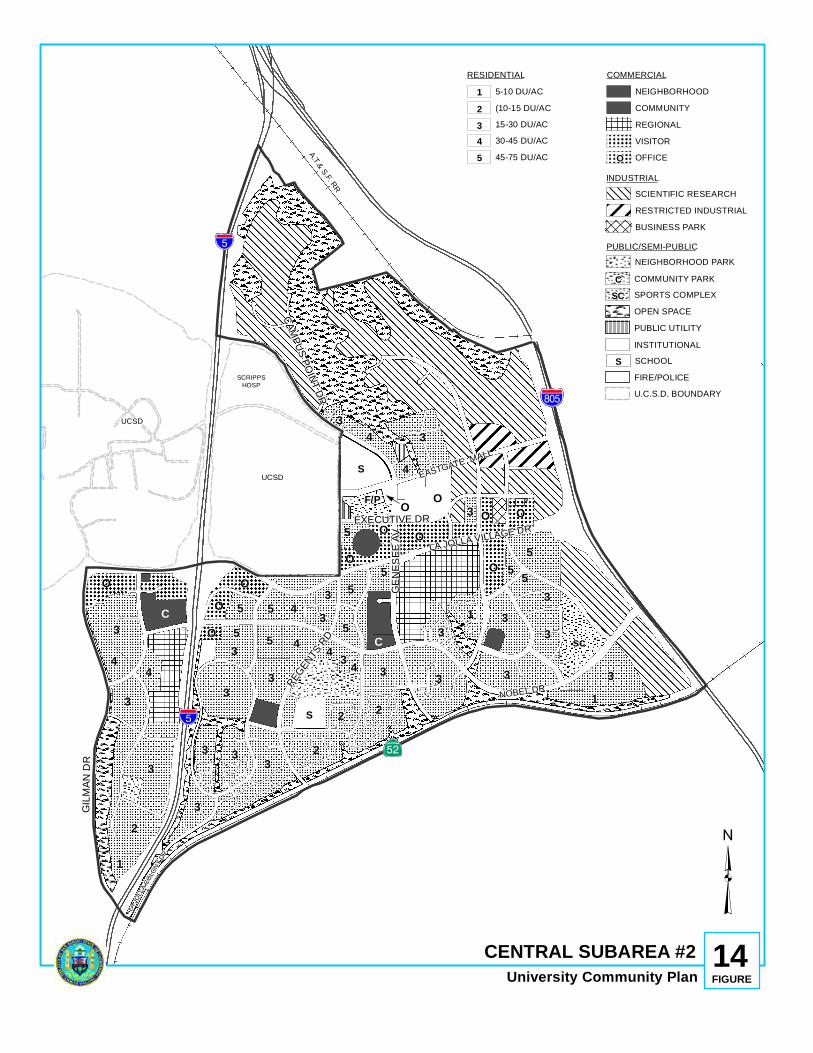
%&s(
S
SCRIPPSHOSP
UCSD
UCSD
!"̂$
!"̂$
?nE
S
3
3
44
C
O
O
O
OO
O
C
3
2
1
3
3
3
3 3
33 445
55
55
5
54
33
3
2
33 4
22NOBEL DR
3
5
3
34
4
5
3
3
35 5
13
31
O sc
F/P O 3 O
O
OA.T.& S.F. RR
O
EASTGATE MALL
LA JOLLA VILLAGE DR
LA JO
LLA C
OLON
Y DR
GENE
SEE A
V
GILM
AN D
R
CAMPUS POINT DR
EXECUTIVE DR
REGEN
TS RD
CENTRAL SUBAREA #2University Community Plan
14FIGURE
³
SCIENTIFIC RESEARCHRESTRICTED INDUSTRIAL
NEIGHBORHOOD PARK
OPEN SPACE
INSTITUTIONAL
RESIDENTIAL COMMERCIAL
INDUSTRIAL
PUBLIC/SEMI-PUBLIC
U.C.S.D. BOUNDARY
C COMMUNITYNEIGHBORHOOD
REGIONALVISITOR
F/P FIRE/POLICE
COMMUNITY PARK CSPORTS COMPLEXSC
45-75 DU/AC530-45 DU/AC415-30 DU/AC3(10-15 DU/AC25-10 DU/AC1
SCHOOLS
OFFICEO
PUBLIC UTILITY
BUSINESS PARK
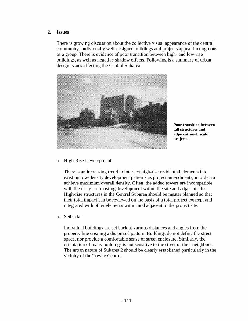
- 111 -
2. Issues
There is growing discussion about the collective visual appearance of the central community. Individually well-designed buildings and projects appear incongruous as a group. There is evidence of poor transition between high- and low-rise buildings, as well as negative shadow effects. Following is a summary of urban design issues affecting the Central Subarea.
Poor transition between tall structures and adjacent small scale projects.
a. High-Rise Development
There is an increasing trend to interject high-rise residential elements into existing low-density development patterns as project amendments, in order to achieve maximum overall density. Often, the added towers are incompatible with the design of existing development within the site and adjacent sites. High-rise structures in the Central Subarea should be master planned so that their total impact can be reviewed on the basis of a total project concept and integrated with other elements within and adjacent to the project site.
b. Setbacks
Individual buildings are set back at various distances and angles from the property line creating a disjointed pattern. Buildings do not define the street space, nor provide a comfortable sense of street enclosure. Similarly, the orientation of many buildings is not sensitive to the street or their neighbors. The urban nature of Subarea 2 should be clearly established particularly in the vicinity of the Towne Centre.

- 112 -
c. Superblocks The superblock concept orients activities and amenities towards the interior of developments away from the street. The Central Subarea’s superblocks are further “barricaded” from the street by steep landscaped berms or parking structures adjacent to the sidewalks.
Self-contained, introverted, free-standing development patterns characterize the Central Subarea.
d. Overflight Compatibility
A conflict exists between the desire to maximize development potential and yet stay within the use categories and intensities specified by the Airport Land Use Compatibility Plan for MCAS Miramar.
e. Impacts On Other Subareas/Communities
Traffic generated by the Central Subarea onto La Jolla Village Drive has an effect on the freeway access capacities available to La Jolla, La Jolla Shores and Mira Mesa. Travel generated by this subarea on Genesee Avenue and Regents Road also affect the operation of these streets as they pass through the South University Subarea. The ability of the street system to handle the additional traffic generated by new developments has become the determining factor in the future planning, design and development of the area.
3. Recommendations
The recommendations which follow consist of two parts: OBJECTIVE and ACCOMPLISHED BY. OBJECTIVE:
Improve the central community’s urban form and cohesiveness as new construction activity continues.
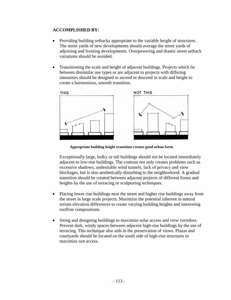
- 113 -
ACCOMPLISHED BY: • Providing building setbacks appropriate to the variable height of structures.
The street yards of new developments should average the street yards of adjoining and fronting developments. Overpowering and drastic street setback variations should be avoided.
• Transitioning the scale and height of adjacent buildings. Projects which lie
between dissimilar use types or are adjacent to projects with differing intensities should be designed to ascend or descend in scale and height to create a harmonious, smooth transition.
Appropriate building height transition creates good urban form.
Exceptionally large, bulky or tall buildings should not be located immediately adjacent to low-rise buildings. The contrast not only creates problems such as excessive shadows, undesirable wind tunnels, lack of privacy and view blockages, but is also aesthetically disturbing to the neighborhood. A gradual transition should be created between adjacent projects of different forms and heights by the use of terracing or sculpturing techniques.
• Placing lower rise buildings near the street and higher rise buildings away from the street in large scale projects. Maximize the potential inherent in natural terrain elevation differences to create varying building heights and interesting roofline compositions.
• Siting and designing buildings to maximize solar access and view corridors.
Prevent dark, windy spaces between adjacent high-rise buildings by the use of terracing. This technique also aids in the preservation of views. Plazas and courtyards should be located on the south side of high-rise structures to maximize sun access.

- 114 -
• Articulating the building mass with offsets, changes of plane, stepped terraces and irregular architectural edges. The base of buildings should relate to the needs of pedestrians and motorists, thus, this is the place for texture, color, special amenities, architectural detailing and other visual interest. External materials that are sympathetic in color and texture to the existing patterns should be used.
Variations in planes of wall surfaces create interesting environments.
• Utilizing building elements, colors and materials that are not disturbing to the eye. The eye is usually disturbed by lack of unity, asymmetrical balance, and bad proportion.
• Concealing rooftop equipment, vents and shafts from view from adjacent high-rise buildings. Similarly, trash storage, mechanical equipment, utility appurtenances and service areas should be screened with walls, doors or landscaping.
• Requiring that all structures above 50 feet in height submit solar access and shadow studies as part of the permit application process.
• Requiring that roads and open space areas within a large development be coordinated with the roads and open spaces of adjacent and facing projects, and aligned so as to form a continuous network.

- 115 -
• Providing areas for employees that include seating, sunny plazas and recreational facilities.
• Providing a minimum 50-foot-wide landscaped open space easement along the
east side of Gilman Drive to maintain open space continuity and buffer from roadway.

- 116 -
• Requiring a minimum 100-foot street yard between the I-805 off-ramp into La Jolla Village Drive and the nearest building walls of future development, to maintain open views into the community. Building alignment should complement freeway ramp alignment.
Generous street yards from freeway ramps help maintain open views into the community. Bermed landscaping buffers noise.
• Reducing potential noise effects resulting from I-805 by providing landscaped berms at the periphery of new development in that vicinity.
• Avoiding the location of service roads and fire lanes parallel to the public street. • Providing sidewalks on at least one side of all important private streets within
the project. Ensure that such sidewalks interconnect with other pedestrian paths within and outside the project, particularly with the primary pedestrian network identified in Figure 10.
• Orienting land uses not sensitive to freeway noise such as parking and storage,
towards I-805 and I-5. However, such uses should be screened and designed to give an attractive community image to the passing motorist.
• Avoiding the location of parking and parking entrances adjacent to the
pedestrian network streets. All parking should be in unobtrusive locations, in garages, below grade, tucked under buildings, carports or trellised canopies. If surface parking lots must be provided, they should be dispersed throughout the site in multiple increments located at different levels. Large, single expanses of surface areas parking should be avoided. Surface parking landscaping must conform to the City’s Landscaping Ordinance at a minimum.
- 117 -
• Integrating signage into the site and building design. Corporate symbols or logos should be used rather than corporate names. Signs should be low-scale and located for safety so as not to block motorists’ views of oncoming traffic. Freestanding single pole signs are not permitted. The number and size of signs should conform to the City’s sign regulations. Building facade signage should be limited to the first 40 feet in height above street level.
Directional signage within a project should be located within eye level of pedestrians and motorists. Ensure that the address of each building within a development is clearly marked and visible from the public street. Building and site orientation maps located at major entrances to a project would be helpful in large developments.

THIS PAGE INTENTIONALLY LEFT BLANK.

Subarea 3: Miramar


- 121 -
C. SUBAREA 3: MIRAMAR
1. Background
The Miramar Subarea includes all of the planning area east of I-805 (see Figure 15). This area is developed with industrial uses, including warehouses, distribution centers, storage facilities, and automotive-related commercial uses in a typical strip commercial pattern. Aesthetically, the industrial portion on the north side of Miramar Road can be described as a chaotic conglomeration of structures and signs. MCAS Miramar lies east of the University community planning area. Approximately 50 percent of the aircraft departing the station head in a general northwesterly direction to sea, overflying Subarea 3. To avoid the commercial air traffic, the aircraft departing MCAS Miramar remain at an altitude of 2,000 feet before climbing to higher altitudes. Virtually all the entire area east of I-805 is impacted by average noise levels of 70 decibels (70 CNEL) or greater, and all but a small portion of the eastern edge possesses a significant potential for accidents (Accident Potential Zone II). As a result, most of the area is subjected to both high noise levels and Accident Potential Zone II. To preclude development which would hinder the mission at MCAS Miramar, the Federal Government has acquired easements or fee simple title to privately-owned properties located within and adjacent to Accident Potential Zone II. Additionally, the City of San Diego owns considerable acreage within Accident Potential Zone II and within areas subject to average noise levels of 65 CNEL or greater. Approximately one-third of the area consists of slopes with a gradient of 25 percent or greater. The majority of the steep topography are fingers of Sorrento Valley and Soledad Canyon located north and east of Eastgate Mall.
2. Issues
The urban design issues of this subarea relate to aircraft noise, accident potential, topography and the visual impact of industrial development along Miramar Road. The uses and activities which may be provided in this subarea are very limited and must not concentrate large numbers of people.
3. Recommendations
The recommendations which follow consist of two parts: OBJECTIVE and ACCOMPLISHED BY.

- 122 -
Figure 15. Miramar Subarea #3

- 123 -
OBJECTIVE: Preserve the natural finger canyons which characterize the Miramar Subarea. ACCOMPLISHED BY: • Retaining the A-1-10 Zone on areas designated for open space. • Implementing the Hillside Review Overlay Zone and the Resource Protection
Ordinance (RPO Slope Regulations). OBJECTIVE: Improve the visual image of the industrially developed portion of Miramar Road. ACCOMPLISHED BY: • Screening mechanical equipment and appurtenances and outdoor storage and
designing the utilitarian aspects of development as integral parts of the overall design of the building. Fences, walls, grill work, etc. should be of a similar material and color as the main building.
• Painting buildings in the spectrum of earth tones which blend with the natural
open space character of Subarea 3.
• Landscaping as required by the Citywide Landscape Ordinance. • Prohibiting signs exceeding the height of the building. Other sign criteria
should comply with the City’s sign regulations. • Providing outdoor seating/eating areas for employees.
OBJECTIVE: Enhance the eastern entrance into the community. ACCOMPLISHED BY: • Landscaping the recently constructed median on Miramar Road westerly of the
AT & SF Railroad right-of-way.

THIS PAGE INTENTIONALLY LEFT BLANK.

Subarea 4: South University


- 127 -
D. SUBAREA 4: SOUTH UNIVERSITY
1. Background
South University is defined as an urbanized area in the General Plan. Development consists primarily of single-family residential development. The subarea houses approximately 16,700 persons in 5,700 dwelling units. Commercial centers are clustered along Governor Drive at Regents Road and Genesee Avenue which primarily serve the daily needs of area residents. An office park has been developed on the south side of Governor Drive at I-805, which serves as an employment center. The subarea is bordered by three freeways: I-5 on the west, I-805 on the east and SR-52 on the south (See Figure 16). These freeways and two major canyons: Rose Canyon on the north and San Clemente Canyon (Marian Bear Memorial Park) on the south, isolate as well as define the South University Subarea. Smaller finger canyons bisect the subarea giving it a distinct character and identity. Access to the subarea is available from Regents Road and Genesee Avenue from the south, Genesee Avenue from the north and the Governor Drive exit off of I-805 from the east. No access is planned from the west. Governor Drive connects most land uses in the subarea as it is the only major east-west street. Governor Drive terminates at Stresemann Street. Topographic constraints and the biological and aesthetic value of this section of Rose Canyon preclude the western extension of the road to connect with I-5. The planned extension of Regents Road over Rose Canyon will provide another connection between the northern and southern parts of the University community. The Clairemont Mesa community is located to the south of this subarea on the other side of SR-52. This community contains mostly low-density residential development. Industrial parks border I-5 and higher density residential development is located along portions of the major roads. The gently rolling land of this subarea has been largely developed with single-family residential units. The primary urban core of the community is located approximately one mile to the north and can be accessed from South University by Genesee Avenue, and eventually by Regents Road. Public facilities and services are essentially in place. Two elementary schools, a junior high and a senior high are all located within South University. Marcy Elementary, although still shown as a school site, is currently being leased for other than public school uses. Standley Park on the south side of Governor Drive is fully developed as a community park. All three neighborhood parks have been improved. The University Community Library is located on Governor Drive at Agee Street.
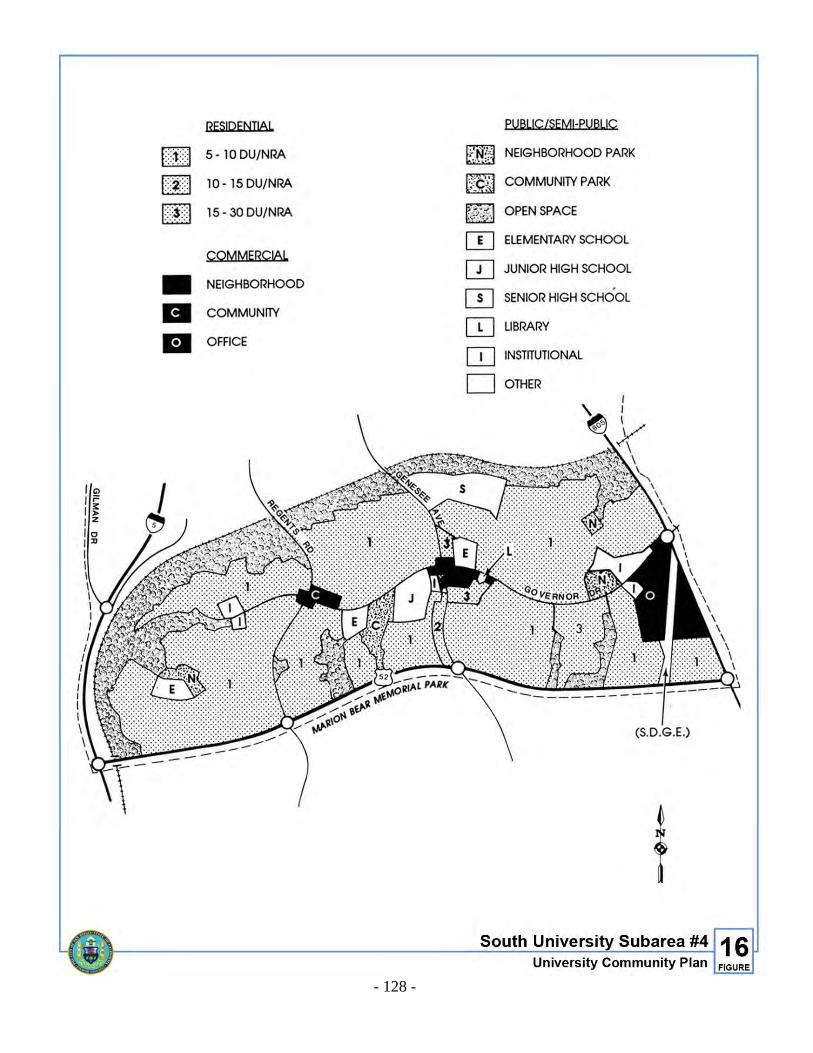
- 128 -
Figure 16. South University Subarea #4
- 129 -
2. Issues The major urban design issue in the South University Subarea relates to infill development. Although this subarea is predominately developed, or committed to development, there still remain vacant parcels which, due to size, location, and/or environmental problems, are of community interest and for which urban design criteria should be defined. Other issues relate to the preservation of Rose and San Clemente Canyons, the privately-owned finger canyons and other open space areas. Recognizing that open space acquisition is not always feasible or possible due to financial constraints, there should be criteria to limit encroachment of development into these canyons. Also important to the community at large, is the design and quality of the proposed Regents Road bridge over Rose Canyon.
3. Recommendations
The recommendations which follow consist of two parts: OBJECTIVE and ACCOMPLISHED BY. OBJECTIVE:
Guide the development of remaining vacant land and the redevelopment of urbanized properties in a manner that enhances the predominately low-density residential quality of South University.
ACCOMPLISHED BY:
• Ensuring that the massing, height and form of new infill projects are similar in
character and reflect the massing, scale, height and form of existing surrounding development, e.g., a non-residential project located next to a residential use should be low scale and incorporate features found in adjacent projects.
A new structure abutting a residential development should not exceed 35 feet in height within 50 feet of the common property line. In multi-structure planned developments, buildings of low scale and height should be located near the street and the periphery of the site while taller and bulkier structures should be located towards the center of the site.
Color and building materials should blend harmoniously with surrounding developments. The street yards of new infill development should be equivalent to the average street yard of existing development on all sides, except between residential and adjacent commercial and office uses where a landscaped buffer of at least 25 feet in width should be provided. (Storage, parking and loading facilities should not be permitted in this buffer area).

- 130 -
OBJECTIVE:
Create an attractive appearance along Governor Drive and define subarea entryways.
ACCOMPLISHED BY:
• Orienting project amenities and front entrances of developments towards
Governor Drive. • Requiring all new parking to be landscaped as per the Citywide Landscape
Ordinance. Avoid the location of surface parking areas adjacent to Governor Drive. Such parking lots should be behind buildings fronting Governor Drive.
• Continuing the undergrounding of telephone and electrical lines. A utility
underground district has been approved for the section of Governor Drive between Gullstrand and Genesee. The section between Genesee and Regents is scheduled for undergrounding in 1990, and the section between Regents and Stresemann for 1991.
• Installing directional signage along Governor Drive which points to major
destination areas within and outside the South University Subarea. • Identifying the South University Subarea by locating signs or symbols at
entryways along Regents Road at SR-52, along Genesee Avenue at SR-52 and Rose Canyon, and along Governor Drive at I-805.
OBJECTIVE: Ensure that the Regents Road bridge across Rose Canyon is compatible with the natural beauty of the canyon. ACCOMPLISHED BY:
• Designing the overpass as a unique landmark and source of pride in the
community. The proposed connection of Regents Road should not be viewed only from a point of view related to function and efficiency. The bridge itself should make a lasting impression, and convey a statement on design which blends harmoniously with the natural beauty of Rose Canyon.
The sides of the structure should provide see-through views of the canyon (i.e. column design as opposed to solid concrete). Landscaping should cascade down the sides of the overpass. The bridge must be designed to accommodate autos, bicycles and pedestrians separated from each other.
- 131 -
OBJECTIVE: Protect Rose and San Clemente canyons as natural regional resources, and preserve the open space character of the various finger canyons which traverse the subarea. ACCOMPLISHED BY: • Prohibiting encroachment of private development into the designated open
space system. • Maintaining open space easements already acquired through subdivision
activity. Future subdivisions should continue to provide easements from new infill developments.
• Limiting development of slopes 25 percent or greater. Only ten percent of such
slopes should be allowed to develop in order to preserve these sensitive lands. In addition, such development must not require grading or consist of impervious surfaces such as parking, tennis courts and similar asphalted flat areas.
• Requiring infill developments to use planned development concepts which
cluster units/buildings and preserve slopes.

THIS PAGE INTENTIONALLY LEFT BLANK.

Transportation Element

- 135 -
TRANSPORTATION ELEMENT I. INTRODUCTION
The transportation of people in the University community, like all communities in the San Diego area, is highly dependent on the private automobile. The accommodation of these private automobile trips is the key constraint on development intensity in the community. Historically, the project application review process has emphasized the compatibility of proposed developments with traffic projections and anticipated street capacities. The relationship between generated traffic and available capacity has been, and will continue to be, a critical consideration in the development of the community. While it is expected that the private car will continue to be the principal means of transportation, it is also true that the land uses proposed by this Plan are of an intensity which could support a wide variety of transportation alternatives. Therefore, this Plan element also attempts to consider the components of a viable, balanced transportation system. Provisions must be made for pedestrians, bicycles, mass transit and other systems within the community.
II. EXISTING CONDITIONS
A. Roads and Streets Figure 17 gives the location and daily volumes of the existing freeways and streets serving the University community. The existing system is operating adequately under current land use conditions. However, the presence of such regional generators as UCSD, the University Towne Centre and major medical-science-research centers, coupled with through traffic accessing the coast via La Jolla Village Drive and Genesee Avenue, has caused notable peak-hour congestion. No current designated truck routes exist in the community, with the exception of the truck access gate provided by UCSD from Regents Road.
B. Mass Transit
1. Bus Service
Currently, bus service in the community is provided by five routes by San Diego Transit Corporation and one route by the North County Transit District, as indicated in Figure 18. The service characteristics and service areas of these routes are indicated in Table 2.

- 136 -
Figure 17. Traffic Volumes 1985-1986
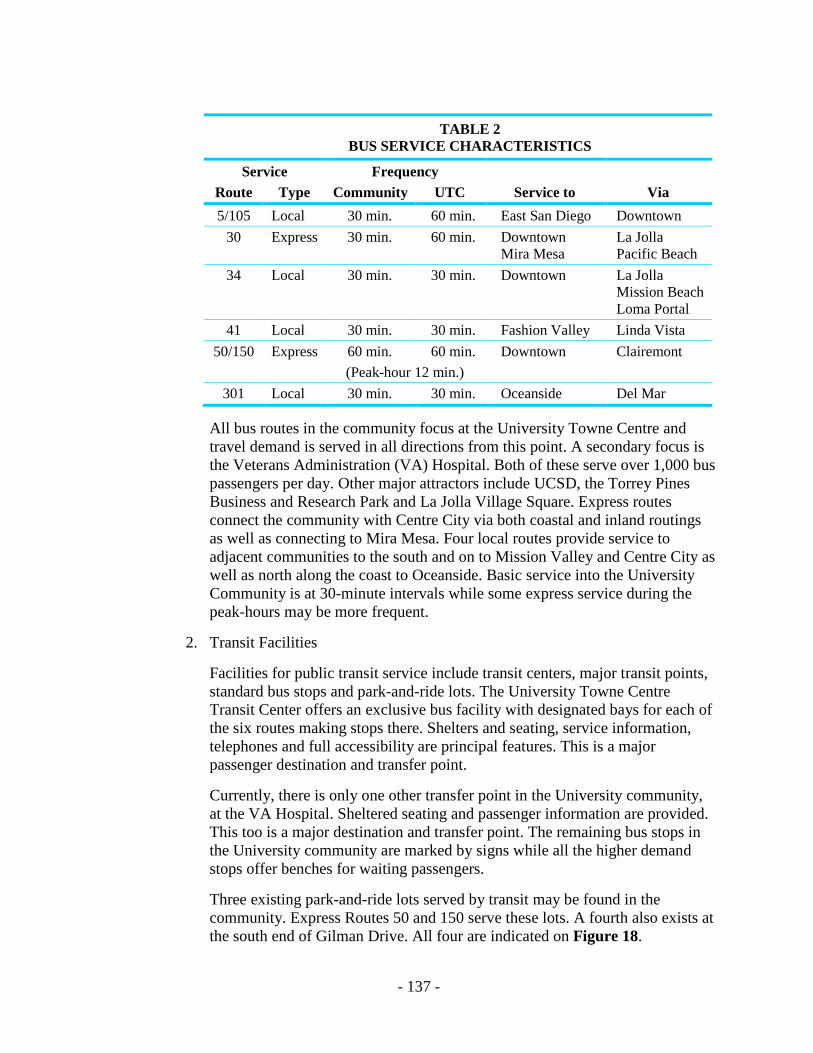
- 137 -
TABLE 2 BUS SERVICE CHARACTERISTICS
Service Frequency Route Type Community UTC Service to Via 5/105 Local 30 min. 60 min. East San Diego Downtown
30 Express 30 min. 60 min. Downtown Mira Mesa
La Jolla Pacific Beach
34 Local 30 min. 30 min. Downtown La Jolla Mission Beach Loma Portal
41 Local 30 min. 30 min. Fashion Valley Linda Vista 50/150 Express 60 min. 60 min. Downtown Clairemont
(Peak-hour 12 min.) 301 Local 30 min. 30 min. Oceanside Del Mar
All bus routes in the community focus at the University Towne Centre and travel demand is served in all directions from this point. A secondary focus is the Veterans Administration (VA) Hospital. Both of these serve over 1,000 bus passengers per day. Other major attractors include UCSD, the Torrey Pines Business and Research Park and La Jolla Village Square. Express routes connect the community with Centre City via both coastal and inland routings as well as connecting to Mira Mesa. Four local routes provide service to adjacent communities to the south and on to Mission Valley and Centre City as well as north along the coast to Oceanside. Basic service into the University Community is at 30-minute intervals while some express service during the peak-hours may be more frequent.
2. Transit Facilities
Facilities for public transit service include transit centers, major transit points, standard bus stops and park-and-ride lots. The University Towne Centre Transit Center offers an exclusive bus facility with designated bays for each of the six routes making stops there. Shelters and seating, service information, telephones and full accessibility are principal features. This is a major passenger destination and transfer point. Currently, there is only one other transfer point in the University community, at the VA Hospital. Sheltered seating and passenger information are provided. This too is a major destination and transfer point. The remaining bus stops in the University community are marked by signs while all the higher demand stops offer benches for waiting passengers.
Three existing park-and-ride lots served by transit may be found in the community. Express Routes 50 and 150 serve these lots. A fourth also exists at the south end of Gilman Drive. All four are indicated on Figure 18.

- 138 -
Figure 18. Existing Transit Service - September 1988

- 139 -
3. Shuttle Loop
In addition to these near-term considerations, the 1971 University Community Plan contained an abstract alignment for an intra-community transit loop, without defining the right-of-way requirements, specific alignments or appropriate technology of the system. Where feasible, right-of-way has been reserved as a condition of development fronting on the shuttle loop corridor. In addition to the reservation, development conditions have required the site design to consider the potential right-of-way and bus stop facilities. In 1985, Parsons Brinckerhoff Quade & Douglas, Inc. were hired to prepare the North University Transit Study which analyzed the feasibility, financing and implementation options for the proposed transit loop. A 4.9-mile loop with six-minute service frequencies in each direction and 15-20 passenger buses was recommended by the study. Financing options were identified and SANDAG, under contract to MTDB, is studying various financing alternatives for implementation of the transit loop. Financing is to be by the private sector through an assessment district, business improvement district, transient occupancy tax, advertising or a combination thereof. An advisory committee including members of the University Community Planning Group, a representative of UCSD and representatives of various businesses was formed to review possible financing mechanisms. When the study is completed a recommendation will be made regarding its financing. An engineering study is also being completed, as a condition of an approved development, to determine how the proposed shuttle can be physically accommodated, and how its operation can be facilitated along the proposed route.
4. Regional and Inter-City Rail
The University community is bisected at Rose Canyon by the tracks of the Atcheson, Topeka and Santa Fe Railroad. No direct service to the community is provided by this alignment at the present time. However, the AT & SF right-of-way has been studied by the MTDB for possible use as a LRT corridor.
SANDAG completed a study of the Mid-Coast Light Rail Alignment in May 1986, which recommended an alignment to be implemented in two phases. The I-5 alternative alignment was recommended by this study primarily because it provides the fastest travel times and has less adverse community impact. A spur alignment on Executive Drive in North University City (from I-5 to the east of I-805) was also recommended to provide service directly to activity centers in University City. Neither alignment has been adopted by the City Council. MTDB has evaluated the recommended alignment, and formally

- 140 -
adopted a “preferred alignment” on January 8, 1987. The alignment adopted by MTDB runs north from I-5 up Gilman Drive and through the UCSD campus with a spur alignment along Executive Drive. This alignment was adopted instead of the I-5 alignment to more directly serve the UCSD campus and because of its lower cost. An alignment on Regents Road was adopted as an alternative. The City does not favor the Regents Road alignment as it does not serve the major activity centers in the University community. After adoption, the precise alignment of the LRT will be subject to further study of development project proposals and subdivision maps, and to further engineering design prior to construction.
C. Parking
There is no notable community-wide parking problem, mainly because it is a newly developing area in which attention has been directed to providing adequate off-street parking. Localized areas, in which development took place under standard zoning, experience some parking shortages. But, for the most part, development in the area has taken place under planned development permits which call for greater off-street parking allocations. The community shopping center, located north of La Jolla Village Square, experiences a high parking demand due in part to the need for additional neighborhood services in North University City. With the development of other neighborhood commercial centers the demand for off-street parking in this shopping center should be reduced. Another development which experiences a parking shortage is Regents Park, located at the northwest corner of La Jolla Village Drive and Genesee Avenue. The parking demand can be attributed to the nature of this development as a phased project. The off-street parking provided by the existing development does not meet the needs of the existing users. With the buildout of the development, additional parking shall be provided and a mixture of land uses developed, more supportive of a shared parking atmosphere. On-street parking is a problem near the University because many students prefer to park off-campus. Included in the Long-Range Development Plan for UCSD is a proposed shuttle system and additional parking structures to serve the growing enrollment.
D. Non-motorized Transportation
1. Existing Bicycles Routes.
The bicycle routes in existence as of September 1986 are listed below and are shown in Figure 23.

- 141 -
EXISTING BIKE ROUTES AS OF SEPTEMBER 1986
Route Limit Class 1. Rose Canyon Bikeway Gilman Drive to Santa Fe Street I 2. La Jolla Colony Drive Gilman Drive to Palmilla Drive II 3. Palmilla Drive La Jolla Colony Drive to Arriba Street II 4. Arriba Street Palmilla Drive to Regents Road II 5. Governor Drive Genesee Avenue to Panel Court II 6. Governor Drive Panel Court to I-805 III 7. Genesee Avenue North Torrey Pines Road to SR-52 II 8. Gilman Drive La Jolla Colony Drive to Sir William Osler
Lane II
9. Miramar Road Gilman Drive to Regents Road II 10. Eastgate Mall Regents Road to Miramar Road III 11. Miramar Road Eastgate Mall to I-15 III 12. La Jolla Shores Drive Torrey Pines Road to North Torrey Pines
Road III
13. North Torrey Pines Road North Torrey Pines Road and Genesee Avenue to UCSD campus
I & II
14. Nobel Drive Regents Road to Genesee Avenue II 15. Interstate 5 Genesee Avenue to Sorrento Valley Road II
2. Pedestrian Facilities
Pedestrian facilities in the University community have been provided as a condition of the approvals of many development projects. These facilities include sidewalks constructed in conjunction with City streets, interior private walkways included in planned commercial developments and planned residential developments, and special facilities such as the pedestrian overpasses which have been constructed over La Jolla Village Drive near Villa La Jolla and from University Towne Center to the Plaza, and over Genesee Avenue from the Plaza to Regents Park. Approved, but not constructed pedestrian overpasses include facilities over Genesee Avenue from University Towne Centre to Costa Verde, and over La Jolla Village Drive from University Towne Centre to Embassy Suites and from Regents Park to Costa Verde. These pedestrian overpasses are discussed more specifically in the Urban Design Element.

- 142 -
III. GOALS
A. Provide a network of transportation systems that are integrated, complementary and compatible with other citywide and regional goals. The network should take into account the physical, social, economic and environmental conditions of the community, both present and future.
B. Provide a balanced public transportation system to link the entire community to all
of its own activity areas and to the San Diego metropolitan area as a whole. C. Encourage alternative modes of transportation by requiring developer participation
in transit facility improvements, the Intra-Community Shuttle Loop and the LRT line.
D. Ensure implementation of Council Policy 600-34, Transit Planning and
Development. IV. PROPOSALS
A. Streets and Highways
1. Street Network
The existing street system should be maintained and operational improvements made, based on proven need, to increase efficiency and accommodate planned growth. Projected traffic volumes and the recommended street network for buildout are illustrated in Figures 19 and 20. Transportation improvements required above and beyond those shown in the 1983 plan are listed below: a. Widen Genesee Avenue to six lanes from Nobel Drive to SR-52.
b. Widen La Jolla Village Drive to eight lanes from west of Villa La Jolla
Drive to I-5, and widen the La Jolla Village Drive bridge over Gilman Drive to six lanes.
c. Construct a full (rather than partial) interchange on I-805 at Nobel Drive.
d. Complete the widening of North Torrey Pines Road to six lanes from
Torrey Pines Scenic Drive to the Callan Road bridge. Widening of the bridge over Callan Road is not required, nor are any further improvements north of the bridge.
e. Provide some type of special treatment (flyovers, additional lanes, etc.) on
Genesee Avenue at North Torrey Pines Road and John Jay Hopkins Drive. f. Provide improvements to the I-5/Genesee Avenue interchange.

- 143 -
g. Provide special treatment, such as extra turn lanes, on Genesee Avenue from I-5 to Nobel Drive.
h. Widen La Jolla Village Drive to eight through lanes from west of Towne
Centre Drive to I-805, and to six through lanes plus two auxiliary lanes on the bridge over I-805.
i. Widen Nobel Drive to six through lanes plus turn lanes as required from
Lebon Drive to Regents Road, and from Genesee Avenue to Town Centre Drive; and construct six lanes from Towne Centre Drive to I-805.
j. Provide the missing ramps (southbound to westbound and eastbound to
northbound) of the I-5/Ardath Road interchange (a regional improvement). k. Require the improvement of John Jay Hopkins Drive as a four-lane major
street as “Conditions of Approval” for any further development of the property to the northeast of the intersection of Genesee Avenue and North Torrey Pines Road.
l. Add a direct connector from northbound I-805 to westbound La Jolla
Village Drive and reconstruct the northbound I-805 offramp to eastbound Miramar Road.
In addition, major street and freeway projects outside the community, including SR-52, and SR-56, should be constructed as soon as possible to provide alternative routes for through traffic accessing I-5 and the coast. Because of air quality impacts that could potentially result from peak-hour congestion, continuous attempts should be made to further mitigate these impacts. The mitigation can take place at the time that precise designs are being prepared for those especially sensitive intersections. This Plan, therefore, recommends that additional mitigation and special designs be considered for those intersections found to be operating at less than satisfactory levels.
2. Governor Drive
This four-lane major street should terminate at Stresemann Street rather than being extended to connect with I-5. Topographic constraints and the biological and aesthetic value of this section of Rose Canyon preclude the western extension of the road.
3. Intensity of Land Use
As indicated in the introduction of this Element, the capability of the street system to sustain traffic volumes is one of the key constraints to development in this community. The land uses and intensities assumed by the traffic study conducted for this Plan are included in the Development Intensity Element.

- 144 -
4. Topographic Alteration
Grading required for street improvements or expansion should be sensitive to the topography. Cut and fill slopes should be minimized and contoured and exposed slopes promptly replanted, preferably with native vegetation.
5. Truck Routes
In that all major commercial centers in the community have access from four major streets, truck activity should be restricted to Governor Drive, Genesee Avenue, La Jolla Village Drive, Nobel Drive and Regents Road. As conditions warrant, consideration should be given to hour limitations on truck movements. All developments should be designed to accommodate truck service areas adequately. Where possible, truck deliveries should be scheduled for non-peak-hour periods. Should truck activities constitute a significant traffic problem consideration of time limitations may be appropriate.
B. Mass Transit
1. Project Integration of Transit Improvements
The travel forecast upon which this Plan relies assumed a regional average of transit service and utilization for the community. This translates to a mode split (i.e. transit use) of two to three percent. Due to the projected traffic congestion in this community, its designation as an urban core and the transit improvements planned, a higher mode split is an appropriate goal. Although a higher mode split would not enable the deletion of the additional street improvements needed to accommodate the level of development projected at buildout, it would help mitigate the low levels of service projected on a number of the major roadways in the community. For this reason improvements needed to ensure the success of regional bus service, the shuttle loop and LRT in the community shall be required as part of the project approval process, consistent with City Council Policy 600-34, Transit Planning and Development. Project applicants shall be required to consult with the San Diego Transit Corporation, the MTDB and other transit implementing agencies to determine the transit improvements needed, and these improvements shall be required as conditions of approval in the permit process.

- 145 -
Figure 19. Projected Traffic Volumes
- 146 -
Figure 20. Recommended Street Network
- 147 -
2. Bus Service
Due to rapid growth in the University community area, significant bus service improvements have been planned. This includes three new express routes: Route 160 offering more direct service to Centre City and also extending on to North City West; Route 130 connecting to the South Bay area by way of I-805; and crosstown Route 70 to Tierrasanta and El Cajon. Selected peak period service will connect to Sorrento Valley. The University Towne Centre Transit Center will remain the focus point for all express and most local service routes. Modifications to existing express service are also recommended. Route 150 will operate over Regents Road and Nobel to the UTC Transit Center, then on to the Lusk Business Park in Sorrento Valley. Route 30 will be rerouted to Mira Mesa via I-805 and Mira Mesa Boulevard. Service along Miramar Road will be provided by new local Route 24 which will also cover Eastgate Mall and connect to the UTC Transit Center. These elements are included in the Metropolitan San Diego Short Range Transit Plan and are shown in Figure 21.
3. Transit Facilities
No additional transit centers are planned for the University community at this time. Two new ones, in North City West and in Kearny Mesa will be developed in adjacent communities which will also serve the University community. MTDB is presently developing a program for adding passenger shelters throughout the San Diego metropolitan area. The University community area is certain to be identified for some of these facilities. Another MTDB program is evaluating transit passenger information and recommendations are forthcoming for bus stop information improvements in route identification, hours of service, service schedules and maps. The existing park-and-ride lot at Gilman and I-5 will serve transit upon implementation of new Route 160. When Route 150 is rerouted in conjunction with the extension of Regents Road, a new park-and-ride facility is recommended at Regents Road and SR-52. A park-and-ride facility is also suggested for the area near Nobel Drive and I-805. This site has high visibility and would supplement the existing lots at the terminus of Governor Drive at I-805. A transit center has been implemented and is located at University Towne Centre. This center provides connections to regional services and will also be used by the shuttle loop for transit access within the community.

- 148 -
Figure 21. Short Range Transit Plan
- 149 -
4. Transit Loop
As proposed in the 1971 and 1983 University Community Plans, the loop shuttle should be developed connecting the UCSD campus, major commercial developments, high-density residential areas, hospital and scientific research facilities and the transit center. This will serve internal trip movements as well as feed the regional bus routes and ultimately the LRT line. The proposed route is illustrated on Figure 22. This route was selected during the 1985 Parsons Brinckerhoff study. It may be subject to change in the future to meet changing service needs. However, this route will be the basis for initiation of service. The final determination of the alignment should be subject to review by UCSD, MTDB and the City. Project approvals fronting the proposed route shall be required to provide additional right-of-way and other improvements identified in the MTDB engineering study. Applicants within the proposed assessment district for the loop shall be required as a condition of approval to participate in and not oppose the formation of an assessment district or other financing mechanism, and to construct bus shelters along the route. This transit system should be privately funded by developers or property owners along the route. The organization of the private funding of ongoing operations should be coordinated by the City, San Diego Transit, SANDAG and MTDB. Participation by UCSD will need to be determined by the University of California, and could ultimately require the approval of the State Legislature.
5. Light Rail Transit System
Encourage the development of a high-speed, light-rail transit system to serve the University community and other northern communities. The Mid-Coast Light Rail Alignment Study, dated April 25, 1986, completed by SANDAG recommended a preferred alignment along I-5 and a spur alignment on Executive Drive from I-5 to the east of I-805 as shown on Figure 22. On January 8, 1987, the Metropolitan Development Transit Board voted to approve a preferred LRT alignment on Gilman Drive continuing through the UCSD campus with a spur to the east on Executive Drive. If the spur alignment is constructed, the major Amtrak/Commuter Rail/Light Rail transfer station should be located adjacent to the Miramar Road overcrossing of the Santa Fe tracks. Gilman Drive/I-5 is an alternate transfer site within this corridor as shown on Figure 22. Possible future LRT stations and park-and-ride facilities are also shown on Figure 22. Projects fronting along the proposed Executive Drive spur shall be required to dedicate sufficient right-of-way to accommodate an on-grade LRT system and stations where necessary.
- 150 -
Figure 22. Proposed Light Rail Transit and Shuttle Loop

- 151 -
6. Transportation System Management (TSM)
Transportation System Management programs are to be implemented in the University community by ordinance and/or through the planned development permit process to aid in the reduction of peak-hour trips. With congestion projected to occur on a number of streets in the community, measures other than street improvements should be pursued. TSM strategies include ride sharing, work hour shifting, parking management, design and publicity to encourage the use of transit and installation of facilities for bicyclists. Private sector participation is envisioned in the planning, financing, implementation and operation of specific TSM actions. Coordination with transit organizations and surveys of tenant origins, modes of travel and work hours are all important elements of a successful program. Preferential parking, provision of company cars or vans for employee use during the day and front door transit access may be provided to encourage transit use and ride sharing. A monitoring program is also an essential element of TSM. Reports by a private association should be required by the City to monitor and assess effectiveness. Goals should be specified and penalties imposed for nonperformance. A review of applicable legislation and ordinances should be made for their applicability to the North University area.
C. Parking
1. Siting
Parking is to be sited and permitted where it best serves other components of the comprehensive transportation system. Conversely, regional and area transit systems should be routed to take advantage of such parking sources as University Towne Centre and La Jolla Village Square. Joint use parking structures or cluster parking areas should be considered to minimize the visual effects of parking lots, improve pedestrian access to major activity centers and provide multiple-use opportunities for parking areas. In general, because development in the community will be almost exclusively in planned developments which feature higher parking ratios than standard zoning, parking demand in the community will be met.
2. Alternate Transportation Incentives
Consideration should be given to conditionally reduce parking requirements for mixed-use project of an urban nature and commercial and industrial establishments which provide transportation or incentives for alternative forms of transportation (i.e. construction of the loop system, carpools, shuttle buses, bicycles, etc.). While the list of possible qualifying alternatives is broad, the incentives should only be granted based on the demonstrated capability of the alternative in reducing parking need. The City Engineer has proposed a citywide shared parking analysis to benefit mixed-use projects which qualify for a reduction in parking requirements. This program should be used for mixed-use projects located in North University City.

- 152 -
3. Coastal Parking Restrictions
Promote the use of shuttle buses, car pools, bicycles and pedestrian movement to reach coastal recreational areas rather than permitting the construction of extensive surface parking in coastal areas. Areas where excess and under-utilized parking exists during summer daylight hours, such as UCSD, could provide a parking reservoir for future shuttle systems to beach areas. This proposal should be reviewed by the UCSD Administration and implemented jointly by UCSD, the City, the State and private developers.
4. UCSD Parking
As identified in the UCSD Traffic Access and Parking Study, an on-campus shuttle system is recommended to reduce vehicle trips, improve on-campus mobility and link the main portion of the campus to remote parking and other uses east of I-5. A proposed parking plan recommends the consolidation of smaller parking lots, replacing them with two proposed main campus garages for visitor and short duration parkers, and in lots for long-term parkers. The proposed plan takes into account the anticipated need to absorb on-campus the loss of some on-street parking along North Torrey Pines Road, La Jolla Village Drive, Torrey Pines Road south of La Jolla Village Drive, and La Jolla Shores Drive in the vicinity of Scripps Institute of Oceanography.
5. Removal of parking along major streets
To accommodate the traffic levels projected in the community, on-street parking may be prohibited along a number of major streets in the community, including La Jolla Village Drive, North Torrey Pines Road and Nobel Drive.
D. Non-motorized Transportation
1. Bikeway System
Implement a program for the development of bikeways with an emphasis on separated bike paths that are interconnecting. Preferably, there should be a grade separation between automobile and bikeways if the lanes are located in the street right-of-way. The existing and recommended bikeway system and bicycle facilities classifications are illustrated in Figures 23 and 24. The proposed routes are listed below. Smaller bikeway linkages should be an integral part of every development via the review of landscape designs of planned development permits and should connect with the community-wide system at various points.

- 153 -
Figure 23. Bikeways
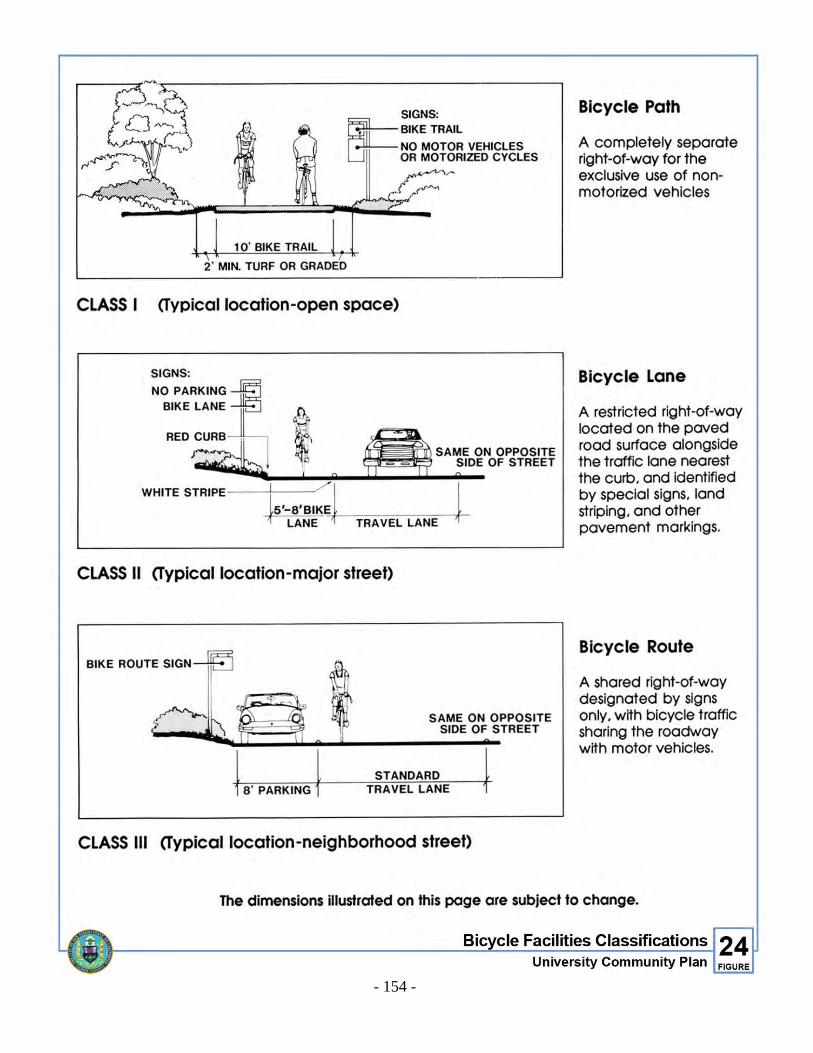
- 154 -
Figure 24. Bicycle Facilities Classifications
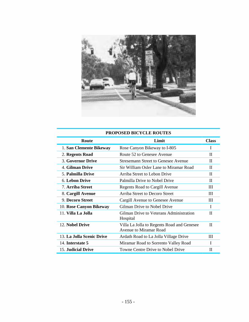
- 155 -
PROPOSED BICYCLE ROUTES
Route Limit Class 1. San Clemente Bikeway Rose Canyon Bikeway to I-805 I 2. Regents Road Route 52 to Genesee Avenue II 3. Governor Drive Stresemann Street to Genesee Avenue II 4. Gilman Drive Sir William Osler Lane to Miramar Road II 5. Palmilla Drive Arriba Street to Lebon Drive II 6. Lebon Drive Palmilla Drive to Nobel Drive II 7. Arriba Street Regents Road to Cargill Avenue III 8. Cargill Avenue Arriba Street to Decoro Street III 9. Decoro Street Cargill Avenue to Genesee Avenue III
10. Rose Canyon Bikeway Gilman Drive to Nobel Drive I 11. Villa La Jolla Gilman Drive to Veterans Administration
Hospital II
12. Nobel Drive Villa La Jolla to Regents Road and Genesee Avenue to Miramar Road
II
13. La Jolla Scenic Drive Ardath Road to La Jolla Village Drive III 14. Interstate 5 Miramar Road to Sorrento Valley Road I 15. Judicial Drive Towne Centre Drive to Nobel Drive II
- 156 -
2. Bicycle Commuting
Bicycle parking facilities shall be installed at major activity centers (e.g. schools, employment centers, shopping centers and recreation centers). Bicycle lockers shall be provided for employees at employment sites. Bicycle racks shall be provided at other major activity centers and for visitors at employment sites. Bicycle racks that lock both wheels and the frame of the bicycle without the use of cables or chains are recommended. Signs shall be installed to indicate the availability of such facilities. Employers are also encouraged to provide showers for employees. (Figure 25)
3. Bicycle Route Signage Official bicycle routes shall be identified by bike route or bike lane signs. In general,
bicycle route signs shall be installed at the following locations:
a. At the beginning and end of the route. b. After the route crosses arterial or collector streets. c. Where the bike route changes direction or streets. d. Every half-mile when the above circumstances do not apply. In addition, “Begin” and “End” plates should be placed on bike route signs at the appropriate locations. Left and right directional arrows and straight ahead plates should be affixed to bike route signs as appropriate when the route changes direction. Also, selected bicycle route signs should have destination plates attached underneath. Destination plates tell the bicyclist which activity centers the route goes to (e.g., University Town Center, UCSD, VA Hospital, etc.). Destination plates should be included at the beginning of bike routes and after the bike route crosses either arterial or collector streets and other bicycle routes.
4. Pedestrian Pathway System
A pedestrian linkage system should be developed connecting residential areas to all activity areas of the community. An emphasis should be placed on separating pedestrian activity from other modes of transportation. In high-volume traffic areas, especially along La Jolla Village Drive and Nobel Drive and near the two regional shopping centers, pedestrian movement should be facilitated by pedestrian bridges with meaningful connections. The sensitive planning of pedestrian paths should be encouraged to increase convenience, provide direct pedestrian access to activity centers and transit, reduce noise and safety conflicts and promote the attractiveness of pedestrian movements. Projects located along four-lane collectors and major streets or primary arterials, shall provide non-contiguous sidewalks with a minimum seven (7) foot landscaped strip and street trees and a six (6) to eight (8) foot paved sidewalk unless

- 157 -
otherwise specified in the Urban Design Element. (Pedestrian linkages are described in greater detail in the Urban Design Element).
5. Recreational Access
Provide pedestrian paths and biking trails for recreational purposes that link open spaces in residential areas to the coast, San Clemente Canyon Park, Rose Canyon and neighborhood parks. If topography and habitat conditions permit, bikeways should follow the proposed open space trails linkages with provisions for adequate buffers between pedestrians and cycles. Both the pedestrian path and bicycle lanes should be sensitively located to minimize disturbance and retain the natural appearance and habitat of the open space areas. Motorized access to the coastal beaches and downtown La Jolla could be provided by connections from parking surplus areas (i.e. UCSD, University Towne Centre, La Jolla Village Square) through either transit routes or special coastal access shuttle systems.
Figure 25. Bicycle Parking
Figure 25. Bicycle Parking

THIS PAGE INTENTIONALLY LEFT BLANK.
Development Intensity Element


- 161 -
DEVELOPMENT INTENSITY ELEMENT I. INTRODUCTION
The purpose of this element is to establish guidelines for intensity of development in the University community. The basis for regulating the intensity of development is the finite traffic capacity of the projected circulation system (freeways and surface streets). This capacity was determined by a series of traffic forecasts which established the maximum feasible vehicular capacity of all roadways in the University community. The development intensities included in the plan are the square footage or dwelling unit limits for any given subarea. An allocation of building square footage or dwelling units per net acre or both is assigned to each subarea in the community and is listed in Table 3 (Land Use and Development Intensity).
II. METHODOLOGY FOR THE ESTABLISHMENT OF SUBAREA DEVELOPMENT INTENSITIES
The community was divided into subareas (Figure 26) and assigned land uses and development intensities in accordance with the goals of the Plan which were tested in a community-wide traffic forecast. The traffic forecast studies, through the use of a computer model, indicated circulation improvements to accommodate the level and types of development expected at buildout. Table 3 identifies, by subarea, the permitted land use and development intensity indicating building square footage, dwelling units per net acre and in some cases average daily trips per acre. The major land uses in the University community are: (1) industrial development with sub-categories of scientific research and restricted industrial; (2) commercial development with sub-categories of office, visitor, and regional, community and neighborhood retail service; and (3) residential development. These categories are specifically described in the land use elements of this Plan. The development intensities are provided in Table 3. For that portion of the University community designated for restricted industrial development the building square footage is based on a “sliding scale” of land uses included in Table 4. The trip generation rates used for the purpose of evaluating projects and for developing the development intensities indicated in Table 3 are provided as an appendix to the plan for information purposes only.
III. GOALS
The proposed land uses and development intensities are based on the following goals: A. Create an urban node with two relatively high-density, mixed-use core areas
located at the University Towne Centre and La Jolla Village Square areas.
- 162 -
B. Develop an equitable allocation of development intensity among properties, based on the concept of the urban node.
C. Provide a workable circulation system which accommodates anticipated traffic
without reducing the Level of Service below “D.”
IV. LAND USE AND DEVELOPMENT INTENSITIES
The Land Use and Development Intensity Table below indicates the levels of development intensity permitted by the Plan. The table below includes the gross acreage (without open space deleted) of parcels in the community. Development potential is based on net acreage (as defined in Section V. D. of this element) to be determined at the time a development application is filed. The square footages for existing development without planned development permits are approximate; the square footage allocated in Table 3 is meant to reflect the actual square footage existing on a site. The development intensity allocations in Table 3 are not intended as a development right, but are subject to other considerations such as site and building design, zoning requirements and other limitations such as the Federal Government easements, the Airport Land Use Compatibility Plan for MCAS Miramar, etc. In addition to helping to ensure a workable circulation system, the Land Use and Development Intensity Table is meant to ensure a balance of land uses in the community. Projects that differ significantly from the land uses or development intensities in Table 3 as determined by the Planning Director, will be found to be inconsistent with the community plan. Such projects would require a Plan amendment. The major goals of the Plan, such as creation of an urban node, maintaining a balance of land uses and ensuring a workable circulation system, will be considered in evaluating the consistency of any project with the Plan. Development intensity and traffic generation will not be the sole factor upon which consistency will be judged.
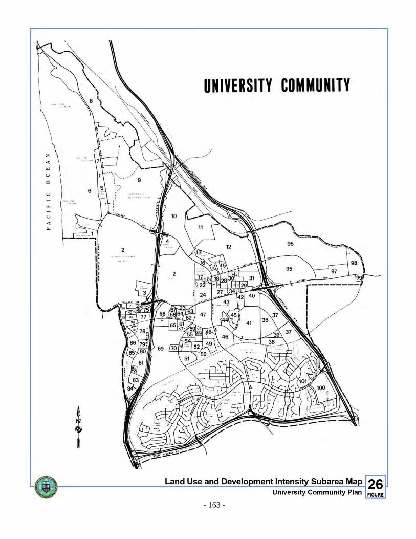
- 163 -
Figure 26. Land Use and Development Intensity Subarea
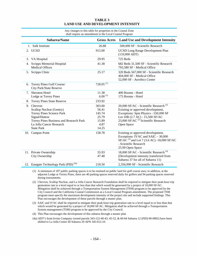
- 164 -
TABLE 3 LAND USE AND DEVELOPMENT INTENSITY
Any changes to this table for properties in the Coastal Zone shall require an amendment to the Local Coastal Program
Subarea/Name Gross Acres Land Use and Development Intensity 1. Salk Institute 26.88 500,000 SF - Scientific Research
2. UCSD 915.00 UCSD Long Range Development Plan (110,000 ADT)
3. VA Hospital 29.95 725 Beds 4. Scripps Memorial Hospital
Medical Offices 41.38 682 Beds 31,500 SF - Scientific Research
793,580 SF - Medical Office 5. Scripps Clinic 25.17 320 Beds 567,000 SF - Scientific Research
404,000 SF - Medical Office 52,000 SF - Aerobics Center
6. Torrey Pines Golf Course/ City Park/State Reserve
728.05 (1)
7. Sheraton Hotel Lodge at Torrey Pines
11.38 6.00 (1)
400 Rooms - Hotel 175 Rooms - Hotel
8. Torrey Pines State Reserve 233.92 9. Chevron
Scallop Nuclear (Gentry) Torrey Pines Science Park Signal/Hutton Torrey Pines Business and Research Park La Jolla Cancer Research State Park
303.60 56.41
145.74 25.79 15.89
4.87
14.25
20,000 SF/AC - Scientific Research (2) Existing or approved development, Exceptions: Spin Physics - 550,000 SF Lot 10B (2.7 AC) - 15,500 SF/AC 23,000 SF/AC (2) Scientific Research Open Space
10. Campus Point 158.78 Existing or approved development, Exceptions: IVAC and SAIC – 30,000 SF/AC (3) and Lot 7 (3.6 AC) -18,000 SF/AC - Scientific Research 25.00 Open Space
11. Private Ownership City Ownership
55.93 47.48
18,000 SF/AC - Scientific Research (4)
(Development intensity transferred from Subarea 37 for all of Subarea 11)
12. Eastgate Technology Park (PID) (4a) 218.50 2,356,990 SF - Scientific Research
(1) A minimum of 187 public parking spaces is to be retained on public land for golf course uses; in addition, at the adjacent Lodge at Torrey Pines, there are 40 parking spaces reserved daily for golfers and 94 parking spaces reserved during tournaments.
(2) Chevron, Scallop Nuclear, and La Jolla Cancer Research Foundation shall be required to mitigate their peak-hour trip generation rate to a level equal to or less than that which would be generated by a project of 18,000 SF/AC. Mitigation shall be achieved through a Transportation System Management (TSM) program to be approved by the City Council and the California Coastal Commission as a Local Coastal Program amendment. The proposed TSM program must specify the maximum development intensity of the project site and include supported findings. This Plan encourages the development of these parcels through a master plan.
(3) SAIC and IVAC shall be required to mitigate their peak-hour trip generation rate to a level equal to or less than that which would be generated by a project of 18,000 SF/AC. Mitigation shall be achieved through a Transportation System management (TSM) program to be approved by the City Council.
(4) This Plan encourages the development of this subarea through a master plan
(4a) ADT’s from Irvine Company owned parcels 343-122-40-43, 45-52, & 60-64 Subarea 12 (PID) 90-0892) have been shifted to La Jolla Centre III Subarea 29 APN 345-012-10.
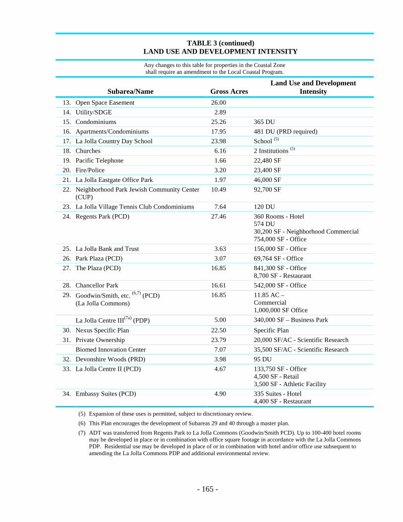
- 165 -
TABLE 3 (continued) LAND USE AND DEVELOPMENT INTENSITY
Any changes to this table for properties in the Coastal Zone shall require an amendment to the Local Coastal Program.
Subarea/Name Gross Acres Land Use and Development
Intensity 13. Open Space Easement 26.00 14. Utility/SDGE 2.89 15. Condominiums 25.26 365 DU 16. Apartments/Condominiums 17.95 481 DU (PRD required) 17. La Jolla Country Day School 23.98 School (5)
18. Churches 6.16 2 Institutions (5)
19. Pacific Telephone 1.66 22,480 SF 20. Fire/Police 3.20 23,400 SF 21. La Jolla Eastgate Office Park 1.97 46,000 SF 22. Neighborhood Park Jewish Community Center
(CUP) 10.49 92,700 SF
23. La Jolla Village Tennis Club Condominiums 7.64 120 DU 24. Regents Park (PCD) 27.46 360 Rooms - Hotel
574 DU 30,200 SF - Neighborhood Commercial 754,000 SF - Office
25. La Jolla Bank and Trust 3.63 156,000 SF - Office 26. Park Plaza (PCD) 3.07 69,764 SF - Office 27. The Plaza (PCD) 16.85 841,300 SF - Office
8,700 SF - Restaurant 28. Chancellor Park 16.61 542,000 SF - Office 29. Goodwin/Smith, etc. (6,7) (PCD)
(La Jolla Commons) 16.85 11.85 AC –
Commercial 1,000,000 SF Office
La Jolla Centre III(7a) (PDP) 5.00 340,000 SF – Business Park 30. Nexus Specific Plan 22.50 Specific Plan 31. Private Ownership 23.79 20,000 SF/AC - Scientific Research
Biomed Innovation Center 7.07 35,500 SF/AC - Scientific Research 32. Devonshire Woods (PRD) 3.98 95 DU 33. La Jolla Centre II (PCD) 4.67 133,750 SF - Office
4,500 SF - Retail 3,500 SF - Athletic Facility
34. Embassy Suites (PCD) 4.90 335 Suites - Hotel 4,400 SF - Restaurant
(5) Expansion of these uses is permitted, subject to discretionary review.
(6) This Plan encourages the development of Subareas 29 and 40 through a master plan.
(7) ADT was transferred from Regents Park to La Jolla Commons (Goodwin/Smith PCD). Up to 100-400 hotel rooms may be developed in place or in combination with office square footage in accordance with the La Jolla Commons PDP. Residential use may be developed in place of or in combination with hotel and/or office use subsequent to amending the La Jolla Commons PDP and additional environmental review.
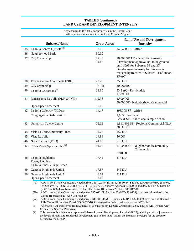
- 166 -
TABLE 3 (continued) LAND USE AND DEVELOPMENT INTENSITY
Any changes to this table for properties in the Coastal Zone shall require an amendment to the Local Coastal Program.
Subarea/Name Gross Acres Land Use and Development
Intensity 35. La Jolla Centre I (PCD) (7b) 3.17 143,400 SF - Office 36. Neighborhood Park 30.00 37. City Ownership 87.40
14.45 18,000 SF/AC - Scientific Research (Development approval not to be granted until 1995 for Subareas 36 and 37. Development intensity for this area is reduced by transfer to Subarea 11 of 18,000 SF/AC)
38. Towne Centre Apartments (PRD) 23.79 256 DU 39. City Ownership 7 – 8 30 DU/AC 40. La Jolla Crossroads(8) 33.80 33.8 AC - Residential,
1,809 DU 41. Renaissance La Jolla (PDR & PCD)
Open Space Easement
112.96
15.06
2,500 DU 50,000 SF - Neighborhood Commercial
42. La Jolla Gateway (PCD)7c 14.17 396,305 SF - Office Congregation Beth Israel 7c 2,165SF – Chapel
62,931 SF – Sanctuary/Temple School 43. University Towne Centre 75.35 1,811,409 SF - Regional Commercial GLA
300 DU(9) 44. Vista La Jolla/University Pines 12.26 257 DU 45. Vista La Jolla 14.84 56 DU 46. Nobel Terrace (PRD) 41.05 716 DU 47. Costa Verde Specific Plan(8) 54.00 178,000 SF - Neighborhood/Community
Commercial 2740 DU
48. La Jolla Highlands Torrey Heights La Jolla Pines Village Green
17.42 474 DU
49. Genesee Highlands Unit 2 17.87 246 DU 50. Genesee Highlands Unit 3
Open Space Easement 8.61
13.60 211 DU
(7a) ADT’s from Irvine Company owned parcels 343-122-40-43, 45-52, & 60-64, Subarea 12 (PID 90-0892);345-012-09, Subarea 35 (PCD 83-0131); 345-011-15, 16-, & 23, Subarea 42 (PCD 82-0707); and 345-120-17, Subarea 67 (PRD 96-0638) have been shifted to La Jolla Centre III Subarea 29, APN 345-012-10.
(7b) ADT’s from Irvine Company owned parcel 345-012-09, Subarea 35 (PCD 83-0131) have been shifted to La Jolla Centre III Subarea 29, APN 345-012-10.
(7c) ADT’s from Irvine Company owned parcels 345-011-15 & 16 Subarea 42 (PCD 82-0707) have been shifted to La Jolla Centre III Subarea 29, APN 345-012-10. Congregation Beth Israel not a part of ADT Shift.
(8) After 558 ADT transferred from Subarea 47 to Subarea 40, La Jolla Crossroads, 2,602 unused ADT remain with CostaVerde Specific Plan Area.
(9) This property is subject to an approved Master Planned Development Permit (MPDP), which permits adjustment to the levels of retail and residential development (up to 300 units) within the intensity envelope for the property defined by the MPDP.

- 167 -
TABLE 3 (continued) LAND USE AND DEVELOPMENT INTENSITY
Any changes to this table for properties in the Coastal Zone shall require an amendment to the Local Coastal Program.
Subarea/Name Gross Acres Land Use and Development Intensity 51. Genesee Highlands Unit 4 26.02 340 DU 52. Playmoor Terrace 11.89 168 DU 53. Genesee Highlands Unit 6 4.78 72 DU 54. Doyle Elementary School
School Expansion 12.73
5.88 1000 Students
55. Doyle Community Park 12.63 2.97 4.29
56. 2.50 50 DU 57. 2.11 139 DU 58. Genesee Highlands Unit 1
Whispering Pines 2.06 60 DU
59. Lincoln La Jolla 4.54 251 DU(10) 60. The Pines (PRD) 5.72 248 DU 61. (PRD) 10.08 368 DU 62. La Jolla Village Park (PRD) 12.00 333 DU 63. La Jolla Village Park (PRD) (included in 62) 64. Fredericks La Jolla Village Park (PRD) 6.83 302 DU 65. La Jolla International Gardens (PRD) 11.43 774 DU 66. La Jolla Garden Villas (PRD) 4.08 277 DU 67. La Jolla Apartments (10a) 4.70 232 DU 68. University Center/Aventine 37.59 400 Rooms - Hotel
40,500 SF - Retail 550,000 - Office 685 DU
69. La Jolla Colony 158.50 3,594 DU 70. La Jolla Colony 7.02 72,645 SF - Neighborhood Commercial 71. La Jolla Professional Center 6.78 168,383 SF - Office/Bank
21,533 SF - Restaurant 72. Gas Station 1.06 4,900 SF 73. 1.00 3,400 SF - Bank
25,674 SF - Office 74. 2.00 97,689 SF - Office
(10) The land use designation for this property has been revised from 30-45 du/acre to 45-75 du/acre although no more than 251 units are permitted on the site which occupies 3.71 net acres.
(10a) ADT’s from Irvine Company owned parcel 345-120-17, Subarea 67 (PRD 96-0638) have been shifted to La Jolla Centre III Subarea 29, APN 345-012-10.

- 168 -
TABLE 3 (continued) LAND USE AND DEVELOPMENT INTENSITY
Any changes to this table for properties in the Coastal Zone shall require an amendment to the Local Coastal Program.
Subarea/Name Gross Acres Land Use and Development Intensity 75. La Jolla Village Inn 7.89 400 Rooms - Hotel 76. Neighborhood Commercial (PCD) 1.50 16,570 SF - Neighborhood Commercial
3,500 SF - Bank 77. Ralphs Shopping Center (PCD) 15.46 150,000 SF - Community Commercial 78. La Jolla Village Square (PCD)
Residential 27.47
2.83 1,002,000 SF - Regional Commercial 108 DU
79. Cape La Jolla 12.10 (included in 78) Regional Commercial/52 DU
80. The Woodlands 6.60 125 DU 81. Woodlands/West/East Bluff/La Jolla Park Villas 34.09 679 DU 82. Villa La Jolla Neighborhood Park 5.60 83. La Jolla Village Townhomes 23.21 291 DU 84. La Jolla Village Townhomes
Open Space 17.18 31.45
106 DU
85. La Jolla Village 6.84 204 DU 86. Villa La Jolla 18.29 548 DU 87. J.W. Jones 10.85 456 DU 88. Villas Mallorca 7.04 136 DU 89. Villas Mallorca Phase II (included in 88) 90. Woodlands North 5.93 120 DU 91. Cambridge 5.24 112 DU 92. Boardwalk La Jolla 8.35 216 DU 93. Broadmoor 10.37 156 DU 94. The Residence Inn 8.50 288 Suites - Hotel 95. Miramar Marine Corps Air Station 176.31 96. 305.35 Restricted Industrial (see Table 4) 97. 43.22 Restricted Industrial (see Table 4) 98. 41.20 Restricted Industrial (see Table 4) 99. Longpre Auto Sales 6.47 33,650 SF - Auto Sales
100. Governor Park 55.00 913,728 SF - Office 101. City Ownership
Private Ownership .82
15.00 15,250 SF/AC - Office Institutional Use (School, Church, etc.)
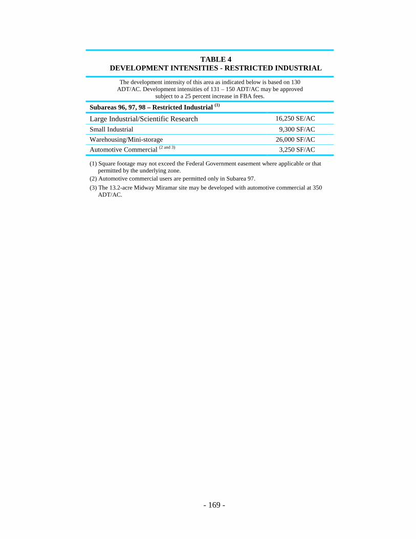
- 169 -
TABLE 4 DEVELOPMENT INTENSITIES - RESTRICTED INDUSTRIAL
The development intensity of this area as indicated below is based on 130 ADT/AC. Development intensities of 131 – 150 ADT/AC may be approved
subject to a 25 percent increase in FBA fees.
Subareas 96, 97, 98 – Restricted Industrial (1)
Large Industrial/Scientific Research 16,250 SE/AC Small Industrial 9,300 SF/AC Warehousing/Mini-storage 26,000 SF/AC Automotive Commercial (2 and 3) 3,250 SF/AC
(1) Square footage may not exceed the Federal Government easement where applicable or that permitted by the underlying zone.
(2) Automotive commercial users are permitted only in Subarea 97. (3) The 13.2-acre Midway Miramar site may be developed with automotive commercial at 350
ADT/AC.
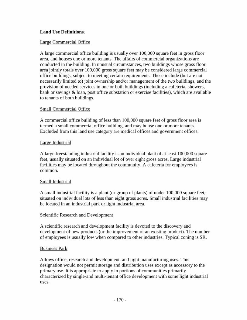
- 170 -
Land Use Definitions: Large Commercial Office A large commercial office building is usually over 100,000 square feet in gross floor area, and houses one or more tenants. The affairs of commercial organizations are conducted in the building. In unusual circumstances, two buildings whose gross floor area jointly totals over 100,000 gross square feet may be considered large commercial office buildings, subject to meeting certain requirements. These include (but are not necessarily limited to) joint ownership and/or management of the two buildings, and the provision of needed services in one or both buildings (including a cafeteria, showers, bank or savings & loan, post office substation or exercise facilities), which are available to tenants of both buildings. Small Commercial Office A commercial office building of less than 100,000 square feet of gross floor area is termed a small commercial office building, and may house one or more tenants. Excluded from this land use category are medical offices and government offices. Large Industrial A large freestanding industrial facility is an individual plant of at least 100,000 square feet, usually situated on an individual lot of over eight gross acres. Large industrial facilities may be located throughout the community. A cafeteria for employees is common. Small Industrial A small industrial facility is a plant (or group of plants) of under 100,000 square feet, situated on individual lots of less than eight gross acres. Small industrial facilities may be located in an industrial park or light industrial area. Scientific Research and Development A scientific research and development facility is devoted to the discovery and development of new products (or the improvement of an existing product). The number of employees is usually low when compared to other industries. Typical zoning is SR. Business Park Allows office, research and development, and light manufacturing uses. This designation would not permit storage and distribution uses except as accessory to the primary use. It is appropriate to apply in portions of communities primarily characterized by single-and multi-tenant office development with some light industrial uses.
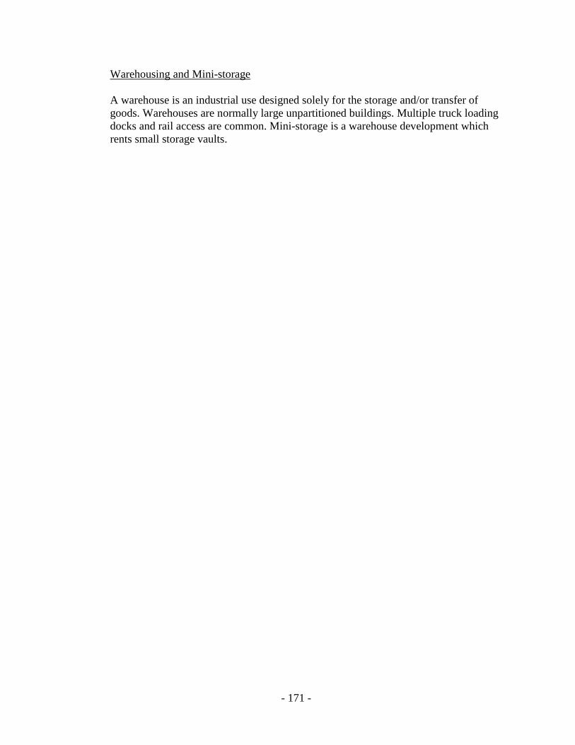
- 171 -
Warehousing and Mini-storage A warehouse is an industrial use designed solely for the storage and/or transfer of goods. Warehouses are normally large unpartitioned buildings. Multiple truck loading docks and rail access are common. Mini-storage is a warehouse development which rents small storage vaults.
- 172 -
V. IMPLEMENTATION OF DEVELOPMENT INTENSITY ELEMENT
A. Community Plan Implementation Overlay Zone (CPIOZ) – Ministerial Review (Permit Type “A”)
The CPIOZ is proposed to be the major implementation tool for the Development Intensity Element. This zone should be applied over the northern portion of the community, i.e., all property north of the railroad tracks (see Figure 27). The purpose of the overlay zone will be to limit uses and development intensity to the levels specified in the Land Use and Development Intensity Table. The southern portion of the community should develop in accordance with the existing zoning with the following exceptions: 1) the Governor Park office park shall be subject to the limitations of the Land Use (Subarea 100) and Development Intensity Table through the M-IP process; and 2) the City-owned parcel designated for institutional uses (Subarea 100) shall also be subject to the limitations in Table 3.
B. Community Plan Implementation Overlay Zone (CPIOZ) – Discretionary Review (Permit Type “B”)
The CPIOZ Type “B” Permit should be applied to sites where zoning is consistent
with the land use designation in the plan, but where special design considerations apply. The sites identified for application of CPIOZ “B” are those where the development regulations of the existing zone are not adequate to ensure that new development is consistent with the goals, objectives and proposals of the community plan or compatible with surrounding development. Without the application of CPIOZ “B,” development in these areas would be subject to ministerial review only, and therefore would not be reviewed for consistency with the goals and proposals of the Plan. The discretionary review of these sites will ensure that development is consistent with the design guidelines contained in the Urban Design Element of the Plan, MCAS Miramar restrictions, that adequate pedestrian circulation is provided and that the architecture, grading, lot coverage, height, bulk and orientation of buildings, etc., is compatible with surrounding development.
The specific issues to be addressed in an application for a Type “B” permit are
listed below. These include:
1. Architectural design of buildings, structures, and signs.
2. Construction materials.
3. Grading and site development. 4. Height and bulk of buildings.

- 173 -
5. Land use, including intensity of land use and accessory uses. 6. Lot coverage. 7. Orientation of buildings. 8. Yards. 9. Pedestrian circulation within the site and connections to adjacent projects. 10. Parking. 11. Safety Zones for MCAS Miramar. 12. Noise. 13. Issues discussed in the Urban Design Element of the Plan. CPIOZ “B” has been applied to the following subareas: - Scripps Clinic (Subarea 5) - Torrey Pines Mesa (Subarea 9) - Campus Point (Subarea 10) - Catholic Diocese (Subarea 67) - La Jolla Village Inn (Subarea 75) - J.W. Jones (Subarea 86) - Restricted Industrial (Subareas 96, 97, 98 and 99). Projects proposed in the Torrey Pines Mesa subareas shall be required to provide 50-foot landscaped setbacks along North Torrey Pines Road, preserve mature trees and provide eucalyptus or Torrey Pine trees along North Torrey Pines Road and Genesee Avenue to maintain the existing landscape theme.
C. Underzones Sites
Properties that require rezoning shall process a Planned Development Permit to ensure consistency with the Plan.
D. Definitions – Net Acreage and Square Footage For the purposes of implementation of the Land Use and Development Intensity Table the following definitions shall be used:
- 174 -
1. Net Acreage That part of a site not designated as open space in the community plan or zoned Hillside Review. Those areas that are zoned for Hillside Review but are not part of a designated open space system may be included as net acreage at the discretion of the Planning Department. Net acreage also excludes dedicated public streets except those public interior streets which are determined by the City Engineer to not be necessary for through circulation. Dedications or reservations for the LRT or shuttle loop may be included in net acreage.
2. Square Footage
The term “square footage” relates to gross floor area. The definition used in the Zoning Ordinance shall apply when calculating square footage. Penthouses for mechanical equipment and elevators shall not be included in the calculation of gross floor area.
E. Transfer of Development Rights (TDRs)
Development rights may be transferred within subdivisions in conjunction with a Planned Development Permit restricting both the sending and receiving sites. Exception: The development intensity assigned to Scripps Clinic, Scripps Memorial Hospital and the Salk Institute may not be transferred to any other properties.
F. Sites With Existing Development
When determining the development potential of a site, existing development shall be subtracted from the total density allocation. For example the developed square footage of a lot created through subdivision will be used in determining the square footage allocation for the undeveloped lot.
G. Development Intensity Bonus The MTDB and SANDAG are considering a Mid-Coast alignment for the LRT which would originate in downtown San Diego and terminate, ultimately, in Oceanside. The purpose of the LRT is to provide the public with an alternative to the automobile. For those properties within one quarter (1/4) mile of the adopted LRT station sites, development intensity bonuses could be granted, if the developer has contributed to the LRT, once the transit system is approved, funded, engineered, rights-of-way acquired (where necessary), and construction dates established. The magnitude of the bonuses will be determined once MTDB and SANDAG are able to undertake and complete the studies necessary to make such determinations. The development intensity bonuses do not apply to any properties within the Coastal Zone.

- 175 -
Figure 27. Community Plan Implementation Overlay Zone Map

THIS PAGE INTENTIONALLY LEFT BLANK.
Housing/Residential Element

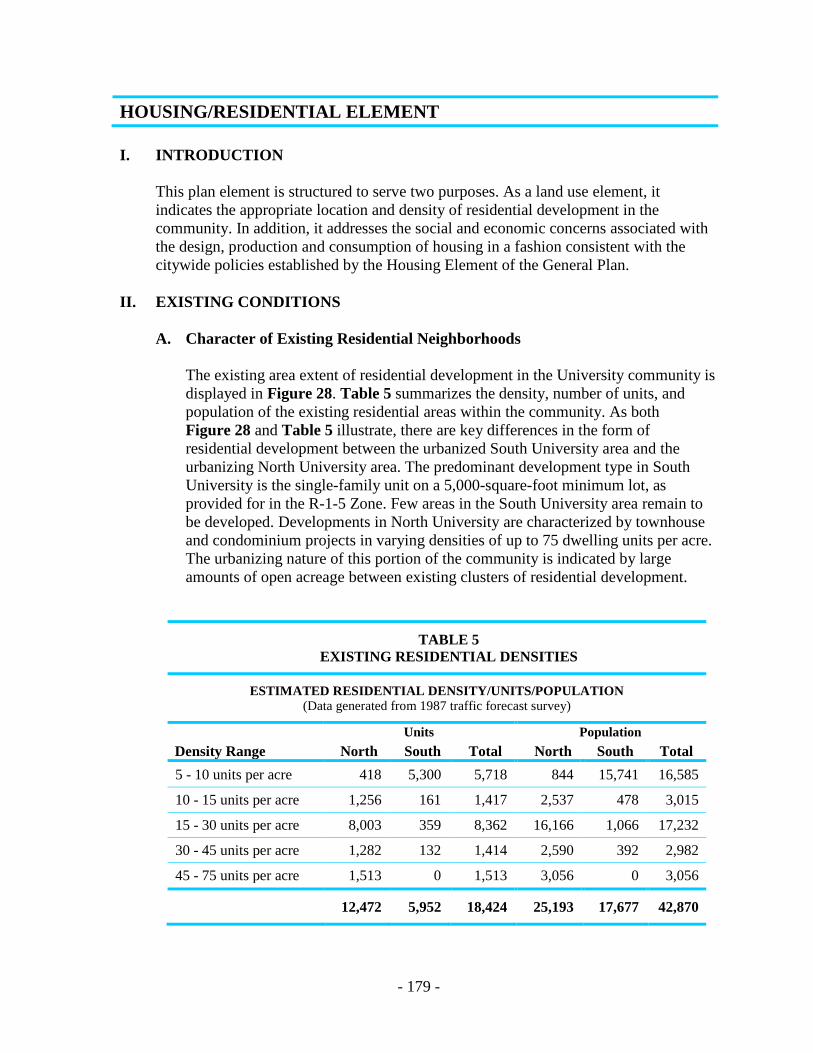
- 179 -
HOUSING/RESIDENTIAL ELEMENT I. INTRODUCTION
This plan element is structured to serve two purposes. As a land use element, it indicates the appropriate location and density of residential development in the community. In addition, it addresses the social and economic concerns associated with the design, production and consumption of housing in a fashion consistent with the citywide policies established by the Housing Element of the General Plan.
II. EXISTING CONDITIONS
A. Character of Existing Residential Neighborhoods The existing area extent of residential development in the University community is
displayed in Figure 28. Table 5 summarizes the density, number of units, and population of the existing residential areas within the community. As both Figure 28 and Table 5 illustrate, there are key differences in the form of residential development between the urbanized South University area and the urbanizing North University area. The predominant development type in South University is the single-family unit on a 5,000-square-foot minimum lot, as provided for in the R-1-5 Zone. Few areas in the South University area remain to be developed. Developments in North University are characterized by townhouse and condominium projects in varying densities of up to 75 dwelling units per acre. The urbanizing nature of this portion of the community is indicated by large amounts of open acreage between existing clusters of residential development.
TABLE 5 EXISTING RESIDENTIAL DENSITIES
ESTIMATED RESIDENTIAL DENSITY/UNITS/POPULATION (Data generated from 1987 traffic forecast survey)
Units Population Density Range North South Total North South Total 5 - 10 units per acre 418 5,300 5,718 844 15,741 16,585
10 - 15 units per acre 1,256 161 1,417 2,537 478 3,015
15 - 30 units per acre 8,003 359 8,362 16,166 1,066 17,232
30 - 45 units per acre 1,282 132 1,414 2,590 392 2,982
45 - 75 units per acre 1,513 0 1,513 3,056 0 3,056
12,472 5,952 18,424 25,193 17,677 42,870

- 180 -
Figure 28. Existing Residential Development
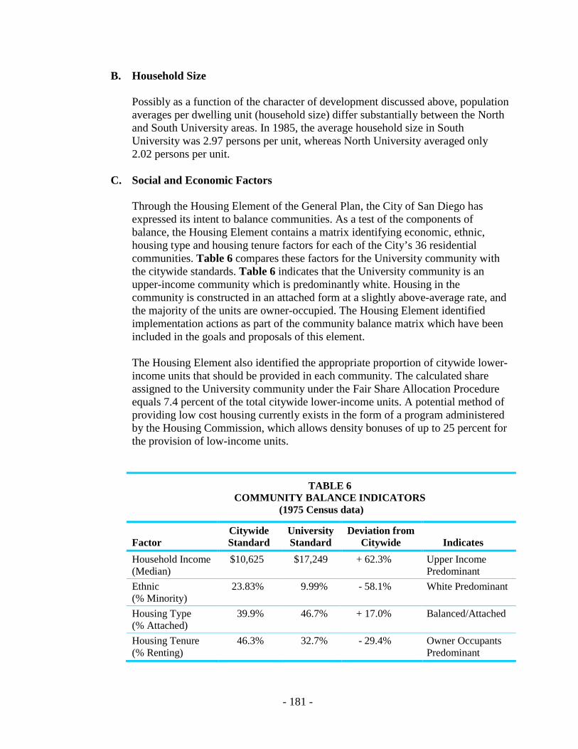
- 181 -
B. Household Size
Possibly as a function of the character of development discussed above, population averages per dwelling unit (household size) differ substantially between the North and South University areas. In 1985, the average household size in South University was 2.97 persons per unit, whereas North University averaged only 2.02 persons per unit.
C. Social and Economic Factors
Through the Housing Element of the General Plan, the City of San Diego has expressed its intent to balance communities. As a test of the components of balance, the Housing Element contains a matrix identifying economic, ethnic, housing type and housing tenure factors for each of the City’s 36 residential communities. Table 6 compares these factors for the University community with the citywide standards. Table 6 indicates that the University community is an upper-income community which is predominantly white. Housing in the community is constructed in an attached form at a slightly above-average rate, and the majority of the units are owner-occupied. The Housing Element identified implementation actions as part of the community balance matrix which have been included in the goals and proposals of this element.
The Housing Element also identified the appropriate proportion of citywide lower-income units that should be provided in each community. The calculated share assigned to the University community under the Fair Share Allocation Procedure equals 7.4 percent of the total citywide lower-income units. A potential method of providing low cost housing currently exists in the form of a program administered by the Housing Commission, which allows density bonuses of up to 25 percent for the provision of low-income units.
TABLE 6 COMMUNITY BALANCE INDICATORS
(1975 Census data)
Factor Citywide Standard
University Standard
Deviation from Citywide Indicates
Household Income (Median)
$10,625 $17,249 + 62.3% Upper Income Predominant
Ethnic (% Minority)
23.83% 9.99% - 58.1% White Predominant
Housing Type (% Attached)
39.9% 46.7% + 17.0% Balanced/Attached
Housing Tenure (% Renting)
46.3% 32.7% - 29.4% Owner Occupants Predominant
- 182 -
Finally, the Housing Element of the General Plan considers the existence of “special populations” which require housing assistance. Among these groups, and of special interest to the University community, is the student population. However, the community should contribute to the student housing needs by providing higher density areas with generally lower rental payments. Where appropriate, density bonus incentives for near campus student housing should be given.
D. Mobile Homes/Manufactured Housing
The Housing Element of the General Plan proposes the use of mobile homes and manufactured housing as a means of stabilizing or reducing the overall cost of housing. No mobile homes or manufactured housing developments currently exist in the University Community Plan area.
III. GOALS
A. Increase the consumer’s freedom of choice terms of tenure and type of housing available.
B. Assure the retention and development of housing affordable by low- and moderate-
income households, especially students and senior citizens. C. Conserve and improve the quality of housing and prevent neighborhood
deterioration. D. Stabilize, and where possible, reduce housing prices and occupancy costs. E. Accommodate the City’s and the community’s fair share of the region’s growth by
designating adequate residential land at appropriate densities and locations. F. Prohibit commercial uses in designated residential areas. G. To protect existing single-family neighborhoods as mandated by the City’s Growth
Management Program.
IV. PROPOSALS
A. Land Use Allocation/Residential Population
1. Figure 29 indicates the location and densities of future residential land use for the community. Table 7 translates Figure 29 into density ranges, dwelling unit totals and projected residential population for the community excluding UCSD. Total residential population is computed based on projected household sizes for North University (2.02) and South University (2.97).

- 183 -
TABLE 7 PROPOSED RESIDENTIAL DENSITY/UNITS/POPULATION
Acres Units Population
North South Total North South Total North South Total
5 - 10 du/ac 130 662 792 718 5,300 6,018 1,450 15,741 17,191 10 - 15 du/ac 88 12 100 1,285 161 1,446 2,596 478 3,074 15 - 30 du/ac 534 12 546 11,610 359 11,969 23,452 1,066 24,518 30 - 45 du/ac 53 3 56 2,075 132 2,207 4,192 392 4,584 45 - 75 du/ac 99 0 99 6,424 0 6,424 13,209 0 13,209
904 689 1,593 22,112 5,952 28,064 44,899 17,677 62,576
B. Housing Types
1. The density ranges listed above will be translated into specific product types (i.e., single-family homes, townhouses, etc.) through the operation of the marketplace and development of individual projects. Historically, the densities listed in Table 7 have resulted in project proposals featuring single-family homes in the five to ten dwelling unit/acre range, townhomes and garden apartments in the ten to 45 dwelling unit/acre ranges and flats and tower development in the ranges above 45 dwelling units/acre. Given the projected unit totals in Table 7, it would be expected that approximately 21 percent of the residential units in the community would be single-family, 55 percent would be townhouse and garden apartments and 24 percent would be located in high-density structures.
2. It should be noted that recent trends have seen the mixing of several unit types
in the larger Planned Residential Development (PRD) Permit applications. Thus, the actual mix of housing product types in the community may vary significantly from the general predictions given above. This diversity within projects should be encouraged so that projects may appropriately respond to market conditions and changing housing needs. However, the mix should be master planned under the PRD Permit process, and amendments to these PRDs should not be made to homogenize the project in response to short-term market trends.
High-rise development should be compatible in scale to the surrounding areas, particularly to other high-rise structures.

!"̂$
!"̂$
%&s(
?nE
SCRIPPSHOSP
UCSD
UCSD
UCSD
PACI
FIC O
CEAN
A.T.& S.F. RRNOBEL D
R
EASTGATE MALL
MIRAMAR RD
GENESEE AV
GILM
AN D
R
LA JOLLA VILLAGE DR
REGE
NTS R
D GOVERNOR DR
NORT
H TO
RREY
PIN
ES R
D
LA JO
LLA C
OLON
Y DR
EXECUTIVE DR
REGENTS RD
RESIDENTIAL DENSITIESUniversity Community Plan 29
FIGURE
³
Residential5-10 DU/AC10-15 DU/AC15-30 DU/AC30-45 DU/AC45-75 DU/AC
- 185 -
C. Balanced Community
1. To achieve economic balance: a) provide very low-, low- and moderate-income affordable assisted housing through the development or exchange of City-owned lands (a potential site is that portion of the Pueblo land south of Nobel Drive designated for residential use); b) provide Density Bonus of up to 25 percent for low- and moderate-income housing pursuant to the City’s Affordable Housing Density Bonus Program; c) provide affordable housing as part of future development agreements, planned development permits, and other projects requiring discretionary reviews; d) consider the provision of single-room occupancy (SRO) and living units as part of future units targeted to low- or very low-income households; and e) provide rent subsidies pursuant to available state and federal housing programs.
2. To achieve ethnic balance: a) require affirmative marketing program as a
condition of tentative map approval; and b) review performance of project developer and associated financial institution, and provide negative reports to regulatory agencies.
3. To achieve balanced housing tenure: a) provide assisted rental housing ,
opportunities and preserve existing nonprofit senior citizen housing under Conditional Use Permits; and, b) provide a range of housing types which are suitable for rental within large-scale Planned Residential Developments.
D. Special Populations
1. To respond to the needs of students in the community: a) encourage the private
development of low-income housing within two miles of the UCSD Campus and the University’s plans for development of student housing on campus; b) allow off-street parking ratios of one space for each two bedrooms through implementing Conditional Use Permits and where location appropriate, with respect to the campus, community commercial centers and transit; c) encourage larger residential units providing two or more bedrooms for student housing; and (d) provide bonus density for affordable assisted housing projects.
E. Mobile Homes/Manufactured Housing
1. The Housing Element recommends that two percent of all new housing in the City be manufactured housing. To meet this goal in the University community would require a total of (566) manufactured units. Such a number of units could be accommodated in the City-owned properties lying outside the 65 CNEL contour of MCAS Miramar and north of Nobel Drive.

- 186 -
2. Given the high value of land and the general density of the residential development proposed for the urbanizing portion of the community, it appears to be infeasible to provide for a major mobile home park location in the University community with the exception of City-owned land. However, the commitment to manufactured housing as an implementation of Proposal #1 above, and opportunities to use advanced mobile home designs as a means of providing on-campus student housing at UCSD and City-owned properties sponsored by the Housing Commission may provide a response to the market segment (including UCSD students) which would normally be addressed by private mobile home development.
F. South University Residential
1. Existing senior citizen housing, especially that developed under conditional use permits should be preserved.
2. The City of San Diego owns open space easements over a 19.5 acre canyon
located between Stadium and Tulane Streets (Parcel A), and a 6,000-square-foot R1-5000 lot (Parcel B). The open space easement on the single-family lot should be revoked and the parcel developed with not more than one single-family dwelling (Figure 30).
3. The canyon located opposite Pennant Way on the east side of Regents Road,
should be preserved as open space, contingent upon the establishment of an assessment district by the adjoining property owners to acquire the property. If an assessment district is not initiated by the benefiting property owners, the proposed alternative use is single-family residential not to exceed three dwelling units per net acre in keeping with the character of the surrounding development and with minimal disturbance to the terrain. A PDR shall be required. (Parcels C and D) (Figure 30).
4. Single-family residential, not to exceed five dwelling units per net acre, should
be developed on the west side of Regents Road between Pennant Way and Governor Drive. Consideration should also be given to the development of housing for the elderly in accordance with the provisions of a conditional use permit. Street design should not permit through traffic between Regents Road and Renault Way. A PRO shall be required. (Parcel E) (Figure 30).
5. University City Village is a special senior-only project of independent and
assisted living dwelling units. University City Village will not exceed 1189 seniors units. Any change to non-senior housing or additional units will require a community plan amendment.
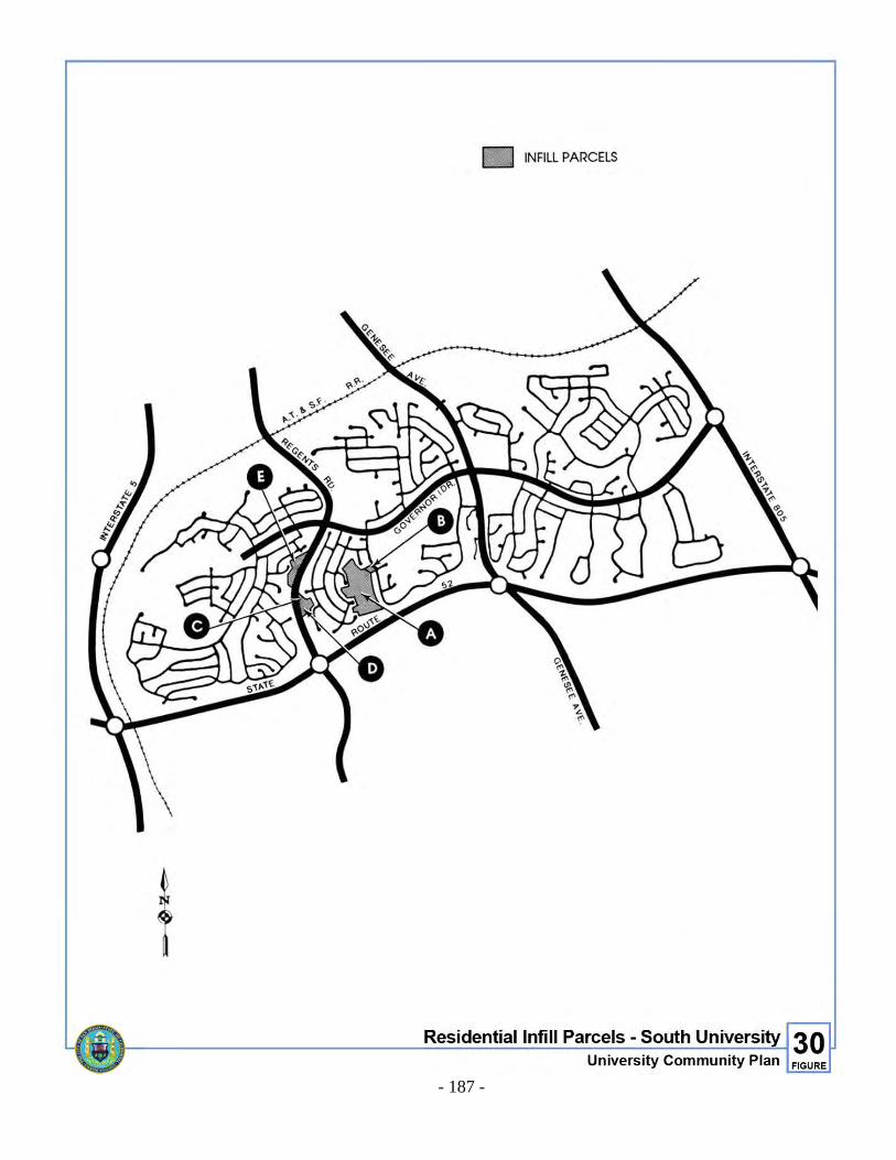
- 187 -
Figure 30. Residential Infill Parcels - South University

- 188 -
G. Protection of Single-Family Neighborhoods
The existing low- and very low-density residential areas shown in Figure 31 are characterized by traditional single-family development i.e., detached housing units on individual lots. These areas are and should continue to be protected as single-family neighborhoods in the future by single-family zoning such as R1-5000 or by a planned residential development permit. Therefore requests for rezonings or other discretionary actions in these areas which could result in construction of any type of residential structures other than traditional single-family residential dwellings, with one dwelling per lot, should be denied.

- 189 -
Figure 31. Single-Family Protection Map

THIS PAGE INTENTIONALLY LEFT BLANK.
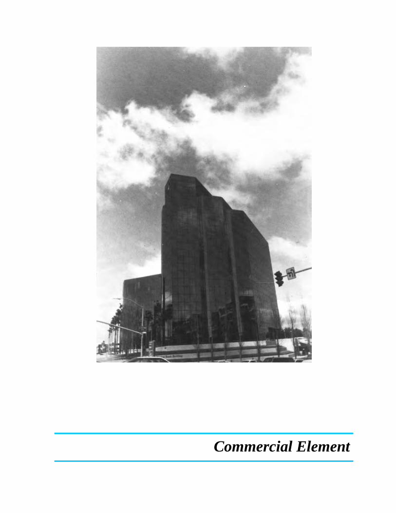
Commercial Element

- 193 -
COMMERCIAL ELEMENT I. EXISTING CONDITIONS
The most important commercial land use trend in the University community during the past decade has been the emergence of the community as a major regional commercial and commercial office center. The regional nature of commercial retailing in the community was initially established by the University Towne Centre. The subsequent development of the La Jolla Village Square Shopping Center has brought the total regional retail commercial space in the community to over 1,350,000 square feet, making it one of the largest centers in the region. In addition to retailing, commercial office and visitor commercial uses have furthered the regional orientation of commercial land use in the community. Recently built office complexes contain structures of over 12 stories in developments containing in excess of 500,000 square feet. Major visitor commercial facilities to support UCSD and nearby industrial/office uses have been built or are under construction. The reasons for the predominance of regional functions in the commercial land mix include: A. High land values which demand large scale and intense forms of development. B. The general momentum for regional uses which was jointly established by the
density allowances in earlier community plans, and the early success of the University Towne Centre project.
C. The excellent access to the University community provided by I-5, I-805
and SR-52.
The regional use predominance has expressed itself in the development characteristics of commercial functions in the community. The North University area commercial development has characteristically been developed as superblocks, in which moderate- or large-scale structure clusters are surrounded by surface parking lots and parking structures to accommodate regional access by private vehicles. These superblocks tend to discourage non-motorized or pedestrian access to the centers, forcing additional vehicle trips within the community and reinforcing the regional nature of the centers. Another more basic concern raised by the residents of the community with respect to the regional dominance of commercial activities in the community stems from the under availability of such neighborhood functions as markets, shops and gasoline service stations. Limited uses are currently located in the area north of Rose Canyon between I-5 and I-805.

- 194 -
Figure 32. Community Commercial Land Use Distribution By Use
- 195 -
These facilities are currently being increased. A neighborhood commercial center is located west of Regents Road off Arriba Street (La Jolla Colony). Other neighborhood commercial developments are proposed at Genesee Avenue and Nobel Drive (Costa Verde), La Jolla Village Drive and Regents Road (Regents Park) and Towne Centre Drive on Excaliber Way (Lake at La Jolla). With these centers in place, the demand for neighborhood uses should be served and would allow residents to walk for everyday goods and services they would usually drive to. The commercial centers on Governor Drive adequately serve the population of the south University area. These centers have witnessed periodic upgrading and renewal as the community has matured. A final commercial issue has been the concern for the intrusion upon industrial lands by commercial functions, as described by the General Plan. The commercial invasion of industrial lands has been limited to date because most of the industrial development in the community has taken place in the SR Zone, which prohibits commercial retail activities. However, the potential for such a problem exists in currently undeveloped industrial lands lying north and east of Eastgate Mall.
II. GOAL
To develop an integrated system of commercial facilities that effectively meets the needs of community residents and visitors as well as assuring that each new development does not impede the economic vitality of other existing commercial areas.
III. PROPOSALS
A. Development Design
Consider project designs and parking layouts which maximize the interconnection of commercial developments with other commercial or residential centers through non-motorized or pedestrian movements. (Additional design guidelines are contained in the Urban Design Element).
B. Industrial Areas
Prohibit the location of commercial uses in designated industrial and science research areas with the exception of commercial services which are clearly intended to serve that specific area.
C. Rehabilitation
Encourage the renewal, and where appropriate, the expansion of regional and community commercial centers to maintain their viability in meeting community needs.
- 196 -
D. Commercial Development Timing
Encourage the simultaneous development of residential and neighborhood commercial uses.
E. Market Area
Review all commercial development projects on a regional, as well as community level, with the review to include the economic impact of the new development on other commercial activities.
F. Landscaping
Suggest drought-resistant landscaping in all new commercial development. Encourage landscaping programs in developed commercial areas as a key element of renewal.
G. South University Neighborhood and Community Commercial Uses
The two existing neighborhood and community commercial centers should be sufficient to serve the area. Additional commercial development should not be permitted along Governor Drive or Genesee Avenue.
H. South University Office Use
1. The 56-acre parcel at the southwest corner of Governor Drive and I-805 should develop with high quality office uses and others permitted by the M-IP Zone. This type of use should not be allowed to expand towards adjacent residential development. Attractive landscaping should be required in project designs to provide an attractive entryway into the South University area from I-805.
2. A landscaped area with a minimum width of 100 feet is proposed as a buffer
between the 56-acre office park and the residences to the south. Required side or rear yards may be located within the landscaped strip; however, storage, parking, and off-street loading facilities are not permitted in the buffer area.
3. Primary access to the office park should be provided from Governor Drive,
access for emergency vehicles only may be permitted from Maynard Street.
4. The following effects should not be permitted to emanate beyond the boundaries of the premises upon which a permitted use is located: a. Air contaminants, including but not limited to smoke, charred paper, paper,
dust, soot, grime, carbon, noxious acids, fumes, gases, odors, or particulate matter, or any combination thereof or any emissions that endanger human health, cause damage to vegetation or property or cause soiling.
- 197 -
(1) Loud, unnecessary or unusual noise which endangers health, peace or
safety of others, or objectionable changes in temperature or direct or sky-reflected glare.
(2) Radioactivity or electrical disturbance which unduly interferes with the
normal operation of equipment or instruments.
5. Restaurants and other businesses and services which cater to the employees should be permitted in a central location not visible from Governor Drive and not intended to serve through traffic.
I. Pedestrian Connections to the Neighborhood
Parking around the commercial center discourages pedestrian access. Extension of pedestrian access should be located from the shopping malls to the surrounding area in the neighborhoods.
IV. LAND USE PROPOSAL SUMMARY
The distribution and location of commercial functions for the community are detailed in Figures 32 and 33. The implementation of the land uses shown in Figure 33 will help to balance the commercial land inventory within the community. The Plan recognizes the continuing role of the community as a major regional commercial retail and commercial office center, by designating sufficient land for those purposes. Regional uses, beyond those shown, should be strongly discouraged. Conversely, the development of projects should not diminish the neighborhood and community serving commercial areas designated.

!"̂$
!"̂$
%&s(
?nE
SCRIPPSHOSPUCSD
UCSD
PACI
FIC O
CEAN
A.T.& S.F. RR
C
C
GENESEE AV
GILM
AN D
R
LA JOLLA VILLAGE DR
REGE
NTS R
D GOVERNOR DR
NORT
H TO
RREY
PIN
ES R
D
LA JO
LLA C
OLONY
DR
EXECUTIVE DR
REGENTS RD
NORTH TORREY PINES RD
COMMERCIAL LAND USESUniversity Community Plan 33
FIGURE
COMMERCIALNEIGHBORHOODCOMMUNITYREGIONALVISITOROFFICE
C
³

Industrial Element


- 201 -
INDUSTRIAL ELEMENT I. EXISTING CONDITIONS
Approximately 750 acres in University City are presently developed with industrial land uses (including scientific research uses). All of the existing and approved industrial sites are located in North University. The two major influences on industrial development in University City have been the presence of MCAS Miramar and UCSD. As a result, the industry in the community can be roughly divided into proposed or planned light manufacturing uses near MCAS Miramar (per existing M-1B zoning) and existing and proposed scientific research uses to the west near UCSD. The aircraft noise and accident potential from MCAS Miramar have restricted residential and commercial development along the Seawolf Departure path and nearby areas. The noise and safety constraints have resulted in a predominance of industrial development along Miramar Road. Most of this development has occurred in the M-1B Zone with light industrial and heavy commercial uses. The Federal Government has purchased permanent easements over approximately 300 acres north of Miramar Road and east of I-805 and 30 acres south of Eastgate Mall and west of I-805 which limits the use and development of the land. The easements restrict permitted land uses to those which are not population-intensive, restricts the height of structures and restricts the gross site coverage of buildings and required parking areas. The industrial area north and east of the University of California has been developing primarily with scientific research facilities as envisioned in the 1971 Plan. This type of industrial use is generally bounded by the Torrey Pines City Park and Torrey Pines State Reserve on the west and northwest, Sorrento Valley on the north, I-805 on the east and the UCSD campus, Scripps Hospital and La Jolla Village Drive on the south. There is also property designated for scientific research south of La Jolla Village Drive just west of I-805. The uses contemplated within the Scientific Research (SR) Zone are research laboratories, supporting facilities, headquarters or administrative offices and personnel accommodations, and related manufacturing activities. A number of facilities specializing in the life sciences have been attracted to the environs of the UCSD campus, including the Salk Institute, Gulf Energy and Environmental System, Calbiochem, Micro Biological Associates and Scripps Clinic. Much of the area is already developed, but some vacant land still exists along North Torrey Pines Road and at Campus Point, located north of Genesee Avenue and east of Interstate 5. A new science research/industrial area, the Eastgate Technology Park, north of Eastgate Mall near I-805, has been approved through a Planned Industrial Development permit and is currently vacant with one lot sold.

- 202 -
II. GOALS
A. Ensure that industrial land needs as required for a balanced economy and balanced land use are met consistent with environmental considerations.
B. Protect a reserve of manufacturing land from encroachment by non-manufacturing
uses. C. Develop and maintain procedures to allow employment growth in the
manufacturing sector. D. Encourage the development of industrial land uses that are compatible with
adjacent non-industrial uses and match the skills of the local labor force. E. Emphasize the citywide importance of and encourage the location of scientific
research uses in the North University area because of its proximity to UCSD. III. PROPOSALS
A. Type of Industrial Use
For compatibility with MCAS Miramar, projects should be consistent with the Airport Land Use Compatibility Plan for MCAS Miramar. When the federal government holds easements restricting use, the easement should provide the control over development. The restrictions in the Development Intensity Element of this Plan also apply to development of these areas.
B. Manufacturing Use
Limit the use of sufficient industrial land to manufacturing, by designation and appropriate zoning, in order to attract industrial uses.
C. Commercial Encroachment
Prohibit through the CPIOZ the location of commercial uses in designated industrial and science research areas with the exception of commercial services which are clearly accessory uses to the primary use. Accessory commercial services should be permitted to ten percent of the gross floor area with the following conditions:
1. The facilities shall be located within the principal building of the project and
shall not be freestanding;
2. Commercial facilities shall be oriented to the interior of the project;

- 203 -
3. Signage shall be minimal and directed toward users on the premises. Any street-oriented signs shall be for directional purposes only; and
4. Advertising for the support of commercial services shall be limited to the
industrial tenants only.
Proposed commercial facilities will provide services that building users would normally drive to. Uses proposed include restaurant/deli, conference rooms, express mail/copy center, athletic club. Exception: Commercial automotive uses are permitted in Subarea 97.
D. Project Site Size
Where physical and ownership conditions permit, encourage the formation or preservation of larger site sizes that can accommodate larger basic sector manufacturing activities.
E. Development Design
Maximize the effectiveness of buffer zones along adjacent non-industrial land uses and major roadways by means of increased distance, topographic relief, sensitive landscaping or a combination of these factors. Based on previous City Council approved permits, a precedent has been established for a 100-foot landscaped buffer to be maintained between residential and industrial land uses.
New projects or major additions to projects should provide an outdoor seating area for employees.
F. Landscaping and Open Space
Recommend drought-resistant landscaping in all new industrial development and retain or revegetate canyon areas and adjacent slopes with native species.
G. Transportation
Conditionally reduce parking requirements for industrial establishments that provide transportation or provide incentives for alternative forms of transportation (car-pools, shuttle buses, bicycles, or mass transit, including the LRT). The ongoing implementation of these programs could be assured through development agreements.
H. Scientific Research Development
In order to maintain the present quality and cohesiveness of existing scientific research parks, the development designs and proposed land uses should be carefully reviewed in these areas. The guidelines in the Urban Design Element
- 204 -
and the Community Plan Implementation Overlay Zone (CPIOZ) should be used to review proposed development.
I. Re-use of Industrial Lands
Redevelopment of industrially zoned land should require a Planned Industrial Development Permit. Those properties restricted by the CPIOZ should be reviewed for consistency with the guidelines set forth in the Development Intensity section of this plan.
Existing, underzoned (A1-10, R1-5000) industrial land shall require a Planned Industrial Development Permit.
IV. LAND USE PROPOSAL SUMMARY
The location of industrial development for the community is detailed in Figure 34. Industrial uses proposed for the community consist of “scientific research,” business park, and “restricted industrial.” North Torrey Pines mesa, Campus Point, Eastgate Technology Park, Subarea 31, portions of Subarea 29 and the City-owned Pueblo land south of La Jolla Village Drive and west of I-805 are designated for scientific research development. The University community is unique because of its proximity to a world-class university specializing in high technology, and scientific research and development. Scientific research uses supportive of UCSD and related scientific uses should be encouraged to develop in this area of the city. Multi-tenant office development is prohibited. A portion located in La Jolla Center is designated business park for office, research and development, and light manufacturing uses. Business park uses serve as a transition area to scientific research, commercial and residential uses and are compatible in nature. The designation for property covered by the Federal Government easements located east of I-805 is “restricted industrial.” Subarea 31 (also affected by Federal Government easements) is designated for scientific research reflecting its proximity to UCSD and the core of the community. Commercial office development is prohibited in this area, however accessory office and retail commercial is permitted as supportive uses for the industrial development in accordance with the Airport Land Use Compatibility Plan for MCAS Miramar. Subarea 98, although not affected by the Federal Government easements, is also designated as restricted industrial. While it is recognized that this area is not restricted by Federal Government easements, the density and light industrial uses allocated in the Development Intensity Element is based on the location of the property in relation to the core and to the fact that there is a similar density limitation for the light industrial areas to the east in Mira Mesa.

!"̂$
!"̂$
%&s(
?nE
SCRIPPSHOSP
UCSD
UCSD
UCSD
PACI
FIC O
CEAN
A.T.& S.F. RR
GENE
SEE A
V
GILM
AN D
R
LA JOLLA VILLAGE DR
REGE
NTS R
D GOVERNOR DR
NORT
H TO
RREY
PINE
S RD
LA JO
LLA C
OLONY
DR
EXECUTIVE DR
REGENTS RD
Industrial Land UsesUniversity Community Plan 34
FIGURE
³
COMMUNITY BOUNDARYSCIENTIFIC RESEARCHRESTRICTED INDUSTRIALBUSINESS PARK

THIS PAGE INTENTIONALLY LEFT BLANK.
Public Facilities Element


- 209 -
PUBLIC FACILITIES ELEMENT I. EXISTING CONDITIONS
The public facilities addressed in this element include schools, police and fire protection, libraries, community centers, utilities and medical facilities. These existing facilities are described below. A. Public Schools
Existing public schools within the community include four elementary schools (grades K-6), one junior high (grades 7-9) and one senior high school (grades 10-12). In addition, the community is served by Torrey Pines Elementary School. Table 8 indicates current enrollments and presently established capacities for the schools serving the community.
TABLE 8 PUBLIC SCHOOL FACILITIES
School Enrollment
(Oct. 3, 1986) Total Operating
Capacity
Curie Elementary 540 600 Torrey Pines Elementary 530 450 Spreckels Elementary 499 720 Doyle Elementary 583 720 Standley Junior High 1,075 1,350 University City Senior High 1,428 1,596
The Marcy, Curie and Spreckels Elementary schools in South University are expected to have sufficient capacities to serve this area through 1995. Marcy Elementary is currently closed and is being leased. The projected elementary enrollment for the area indicates that Curie, Doyle and Spreckels are expected to serve the community. Additional portable facilities may be necessary but the number of additional students expected would not warrant construction of a new elementary school, therefore the previously designated school site adjacent to the Nobel Sports Complex has been deleted. San Diego City School District is studying the enrollment of schools throughout the district, and in some cases, schools are being considered for closure due to enrollment decline and the requirement of desegregation programs. Future reviews of school capacity and enrollments in the existing schools serving the community should take into account future student populations to be generated by the North University area and consider means of transporting those populations to where capacity is extant rather than constructing new schools. Should enrollments in
- 210 -
University area schools decline to the extent that closures are ordered by the District, these sites should be considered for additions to public parks, locations for public or public-assisted housing, or allowed to develop in accordance with surrounding residential uses. Marcy Elementary should continue to be designated in the community plan for use as a school until it can be demonstrated that it is not needed in the future.
The existing secondary schools appear to be adequate to serve projected community needs, although some additional portables will be necessary by the year 2000. Standley Junior High School currently serves the entire University community, and the number of junior high school students is not expected to exceed the maximum capacity. The University City Senior High School should also be adequate to serve the entire University community.
B. Higher Education Facilities
Higher education courses are available to the general public through the UCSD Extension program and the San Diego Community College District. The UCSD Extension offers a range of programs from courses designed for professionals to classes for general enrichment. The Community College District provides classes either on their main campuses or off-campus in existing public facilities. Although community college classes are not currently available in the University community, courses can be taken in satellite classrooms in neighboring communities.
C. Police and Fire Protection
The University community is served by a police substation and fire station located on Eastgate Mall between Regents Road and Genesee Avenue. Additional public safety related facilities and services (e.g., police, fire, and emergency medical response) should be provided to assure levels of service standards are attained for existing development and as development occurs. New facilities should have good vehicular access and be carefully reviewed for environmental, land use and aesthetic impacts. Appropriate equipment and staffing should be assigned to the facilities to assure adequate response to the population and the structure types which may exist in the community.
D. Libraries
No additional library space is proposed. E. Community Centers in Private Projects
Major shopping centers such as the University Towne Centre and La Jolla Village Square constitute natural community focal points. These centers are prime locations for major public-service facilities, which should be provided in conjunction with existing, mixed-use activities. Such activities could include theaters and libraries. The expansion of the Towne Centre’s community facilities

- 211 -
component is highly desirable, as well as the development of additional mall areas or urban open spaces. Regents Park, located at the northwest corner of La Jolla Village Drive and Genesee Avenue, was approved for such community-serving uses as a conference/exhibit area, and community workshop and facilities area. The partnership of private development providing community services should be encouraged for major development in the community.
F. Other Public Facilities
1. City-owned Parcel
The City-owned parcel east of University Gardens Park is designated in this Plan for institutional use. The institutional overlay zone has also been applied. A portion of the parcel is affected by the 65 CNEL noise contour created by MCAS Miramar. The area west of the 65 CNEL line could be developed for use as a school or other institution, while the area east of the 65 CNEL could be used as a church site or other institutional uses compatible with the MCAS Miramar Airport Land Use Compatibility Plan. No improvements or landform alteration may occur within 250 feet of Gullstrand and common access (if the parcel is subdivided) is to be provided on Governor Drive from a point east of the 65 CNEL. A 25-foot buffer is proposed between any buildings and all residential property. No development should occur on the steep slopes adjacent to the park. (This property was offered to residents in the area for purchase as open space through an assessment district. Due to a lack of interest, the City is proceeding with its sale or lease.)
2. Redevelopment of Institutional Sites
Redevelopment of any sites designated for institutional use in South University City (except the City-owned parcel noted above under F.1.) may occur in accordance with the underlying residential zone without the need for a community plan amendment.
G. Utilities
1. Electrical Utilities
Where it is economically feasible, overhead utility lines should be replaced by underground facilities. Undergrounding is not practical for transmission lines, however new development should provide for the undergrounding of distribution service utility lines. If additional distribution lines are proposed in the community, they should be carefully reviewed for environmental, land use and aesthetic impacts.
2. Sewer and Water Facilities
Private development should finance its public utility needs and provide improvements both off-site and on-site in accordance with present Council policy.
- 212 -
II. GOALS A. Develop and maintain a public school system that will enable all students to realize
their highest potential. Pursue the realization of integrated residential neighborhoods to achieve an integrated school system.
B. Provide a high level of service in police and fire protection. C. Encourage the multipurpose use of existing community and private facilities.
III. PROPOSALS A. Public Schools
1. Elementary Schools
Any new schools proposed in the community should only be developed after a review of available school capacity in the community and the consideration of alternative methods of meeting school needs.
2. Future Needs
The capacities and enrollments of schools in the community should be monitored to ensure that any additional facilities can be constructed in sufficient time to preclude overcrowding of the schools.
3. Location
If additional school facilities are needed beyond those shown in Figure 35 the facilities should be located outside of any Safety Zone and the 65-decibel noise contour from Airport Land Use Compatibility Plan for MCAS Miramar.
4. Multipurpose Use of Educational Facilities
The use of school facilities should be maximized by encouraging use of the recreational facilities, sports fields, libraries and meeting rooms for a variety of activities by the community at large.
B. Education Facilities
The UCSD campus should continue to provide educational services and cultural enrichment to the community at large through public use of the museums and libraries and participation in their programs and special events. For maximum efficiency, it is important that linkages and directional signs be constructed to connect other City and community facilities with the state-run campus.

- 213 -
Figure 35. School Sites

THIS PAGE INTENTIONALLY LEFT BLANK.
Open Space and Recreation Element

- 217 -
OPEN SPACE AND RECREATION ELEMENT I. SUMMARY
Open space can be defined as any land area that is generally free from development or developed with very low-intensity or recreational uses that respect natural environmental characteristics. Open space can also include urban areas such as developed parks, private recreational facilities, plazas or malls. Open space can serve a wide range of functions in a community including the preservation of natural resources, the managed production of resources, outdoor recreation, protection of public health and safety, historic and cultural preservation, the control of urban form or design, and scenic or aesthetic enjoyment. The open space and recreation element identifies open space areas in the community which should be retained and enhanced and provides guidelines for their functional integration.
II. EXISTING CONDITIONS
The open space in the University planning area serves primarily three functions: the preservation of topographic or biotic resources and habitats for resident and migratory birds, the provision of outlets for active or passive recreation and the protection of public health and safety. The community possesses a varied and largely undeveloped topography, which provides the opportunity to develop an outstanding open space system.
A. Regional and Resource-Based Open Space
Much of the open space in the community has a regional significance and attraction. The Torrey Pines mesa and coastal area contains the Torrey Pines State Reserve and the Torrey Pines City Park and golf course. The outstanding beach, sheer cliffs, native vegetation and scenic views of the Pacific Ocean make this an area of outstanding beauty. Rose Canyon and San Clemente Canyon are also considered regional resources. Torrey Pines State Reserve consists of approximately 1,100 acres on the northern edge of the community plan area. The reserve contains a variety of landforms and habitats including a beach, coastal bluffs and canyons, mesas and a portion of an estuary. The primary function of the reserve is to preserve natural resources, most notably the Torrey pine tree, but also maritime scrub vegetation, native animal species, coastal aquatic habitat and major geologic landforms. Most of the reserve is located within the community plan area on both sides of Torrey Pines Road. The hiking trails, scenic vistas and beach provide recreational opportunities for the region.

- 218 -
1. Torrey Pines City Park
The Torrey Pines City Park consists of 144 acres of land south of the State Reserve. The park includes a 1,000-foot-long strip of City beach, coastal bluffs, two coastal canyons and a section of mesa top. The park is generally undeveloped, but current uses of the site include hang gliding, model gliding and beach-associated recreation.
2. Torrey Pines Golf Course
The Torrey Pines Golf Course is located northeast of the Torrey Pines City Park. The two golf courses on this mesa have attained national recognition. In addition to the golf course proper, the area includes some lease sites for commercial facilities supportive of the golf course.
3. Rose Canyon
Rose Canyon consists of a well-defined valley floor bordered on the south by steep slopes. Vegetation in the canyon includes mature sycamore and oak trees and other riparian vegetation in the valley bottom, native chaparral species, particularly on the north-facing slopes, and grasses. Major branches of Rose Canyon extend to the north, particularly in the areas east of I-5 and east of the town center. The steep slopes and pronounced valley floor are important scenic assets to the community and can serve to separate and define the neighborhoods to the north and south.
4. San Clemente Canyon
San Clemente Canyon consists of a fairly broad floodplain and steep slopes. Dense stands of mature oak and sycamore trees make this canyon particularly valuable for its native riparian habitat and associated fauna. Approximately 467 acres are owned by the City of San Diego comprising the partially developed Marian R. Bear Memorial Park. Park development has been restricted to a few parking lots, picnic tables, restroom facilities and a hiking trail. Several branches of San Clemente Canyon extend to the north and three branches in the University community are currently preserved as open space by easement. A branch of the canyon also extends into Standley Community Park. Although the update of the Clairemont Mesa Plan shifted the boundary between the University and Clairemont Mesa communities from the southern boundary of the park to SR-52, San Clemente Canyon remains a major open space resource for the University community.
5. Sorrento Valley and Soledad Canyon
The hillsides and canyons along Sorrento Valley and Soledad Canyon form a natural northern boundary to the community. Some of these slopes contain dense stands of native chaparral, while other sections have been disturbed and are vegetated primarily with grasses. This scenic system of slopes preserves native species and natural topography, has value in identifying and separating communities and serves as a scenic resource. Portions of this area are impacted by the noise and crash hazard from MCAS Miramar.

- 219 -
B. UCSD Open Space
The UCSD campus, although not regulated by these Plan recommendations, is an integral part of the “functional community.” Given the close physical, social and economic relationship of UCSD to the University community, the recreational facilities and open spaces of the campus should be integrated with those of the community.
The recreation areas on campus serve primarily the students, faculty and staff of the University. The UCSD main campus contains 61.4 acres of recreational facilities and a total of 126.4 recreational acres are proposed in the Long Range Development Plan (1989). The recreation areas will be located along North Torrey Pines Road and in the central campus area, on both sides of I-5. Currently, 300 acres are undeveloped but long-range plans propose 140 acres as a natural reserve area. Most of the nature reserve would be located on the south side of Genesee, west of I-5 and adjacent to open space slopes along I-5 and adjacent to open space slopes along I-5 and Sorrento Valley.
C. Other Open Space Areas
Several open space areas are interspersed throughout the community, primarily in the form of easements or private open space in planned residential developments. The slopes on the east side of Gilman Drive are preserved as open space by easement and provide a scenic entrance to this part of the community from I-5 and Sorrento Valley. The land in Federal Government ownership within the community plan area is currently vacant. It is anticipated that much of this land will remain in open space because of the noise and crash hazard from MCAS Miramar activities. In addition, some of the land north of Eastgate Mall and east of I-805 will remain undeveloped because of Federal Government easements limiting coverage to 25 percent, as well as steep hillsides and other environmental factors.
D. Population-Based parks
In addition to open space areas of regional significance the University community contains population-based parks to serve local recreation needs. Population-based parks include neighborhood parks, community parks and recreation centers. Neighborhood parks ideally serve between 3,500 and 5,000 persons living within a walking distance of one-half mile. Community parks should serve 18,000 to 25,000 residents within a 1-1/2 mile radius. The community park is intended to provide a wider range of facilities than neighborhood parks, including athletic fields and courts, picnic and play areas, and a recreational building. Existing parks and their development status are listed in Table 9; park locations are illustrated on Figure 24.
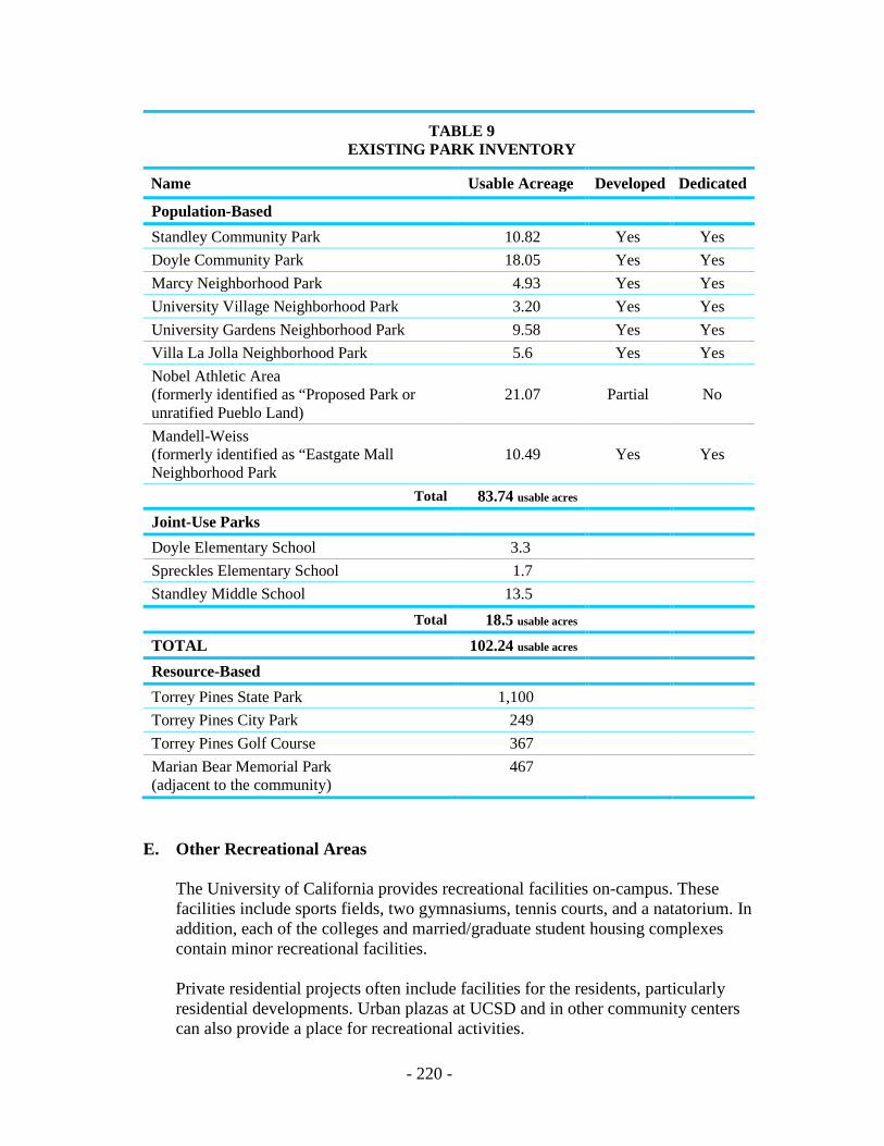
- 220 -
TABLE 9 EXISTING PARK INVENTORY
Name Usable Acreage Developed Dedicated
Population-Based Standley Community Park 10.82 Yes Yes Doyle Community Park 18.05 Yes Yes Marcy Neighborhood Park 4.93 Yes Yes University Village Neighborhood Park 3.20 Yes Yes University Gardens Neighborhood Park 9.58 Yes Yes Villa La Jolla Neighborhood Park 5.6 Yes Yes Nobel Athletic Area (formerly identified as “Proposed Park or unratified Pueblo Land)
21.07 Partial
No
Mandell-Weiss (formerly identified as “Eastgate Mall Neighborhood Park
10.49 Yes
Yes
Total 83.74 usable acres Joint-Use Parks Doyle Elementary School 3.3 Spreckles Elementary School 1.7 Standley Middle School 13.5
Total 18.5 usable acres TOTAL 102.24 usable acres Resource-Based Torrey Pines State Park 1,100 Torrey Pines City Park 249 Torrey Pines Golf Course 367 Marian Bear Memorial Park (adjacent to the community)
467
E. Other Recreational Areas
The University of California provides recreational facilities on-campus. These facilities include sports fields, two gymnasiums, tennis courts, and a natatorium. In addition, each of the colleges and married/graduate student housing complexes contain minor recreational facilities. Private residential projects often include facilities for the residents, particularly residential developments. Urban plazas at UCSD and in other community centers can also provide a place for recreational activities.

!"̂$
!"̂$
%&s(
?nE
SCRIPPSHOSPUCSD
UCSD
PACI
FIC O
CEAN
A.T.& S.F. RR
MARCY PARK
STANDLEY PARK
UNIVERSITY GARDENSPARK
UNIVERSITY VILLAGEPARK
DOYLECOMM. PARK
MANDELLWEISSPARK
TORREY PINESCITY PARK
VILLA LA JOLLAPARK
MARIAN BEAR MEMORIAL PARK
NOBELSPORTSCOMPLEXGE
NESE
E AV
GILM
AN D
R
LA JOLLA VILLAGE DR
REGE
NTS R
D GOVERNOR DR
NORT
H TO
RREY
PIN
ES R
D
VILLA
LA JO
LLA
PARK
REGENTS RD
NORTH TORREY PINES RD
Developed and Undeveloped ParksitesUniversity Community Plan 36
FIGURE
DEVELOPED PARKSITECITY OWNED PARKSITE/UNDEVELOPED
³
- 222 -
III. GOALS
A. Preserve the natural resources of the community through the appropriate designation and use of open space. Major topographic features and biological resources should be preserved as undeveloped open space.
B. Provide a system of population-based parks to meet the community’s needs for
outdoor recreation. C. Establish an open space system that will utilize the terrain and natural drainage
system to guide the form of urban development, enhance neighborhood identity and separate incompatible land uses.
D. Promote public health and safety by designating areas with high potential for
landslides, earthquake faults or aircraft accidents as open space.
E. Develop a linkage system to connect recreational and natural open space areas throughout the community.
IV. PROPOSALS
A. Regional and Resource-Based Open Space
1. General
It is proposed that the Torrey Pines Mesa and coastal area, Sorrento Valley and Soledad Canyon hillsides and canyons, Rose Canyon, San Clemente Canyon and areas most severely impacted by aircraft overflights be preserved as open space. Designated open space is illustrated in Figure 25.
2. Torrey Pines City Park
The park should be developed to enhance unique recreational opportunities, such as beach access and gliding activities, while preserving existing biological and archaeological resources and topographic features.
a. Future improvements to the City Park should be designed to promote
public safety and minimize future environmental damage.
b. The two coastal canyons should be preserved in a natural condition. Presently disturbed vegetation should be restored.
3. Torrey Pines Golf Course/Hotel Development
The golf course facilities should continue to be operated for the benefit of San Diego residents. The additional development of hotel or other facilities should be compatible with the Airport Land Use Compatibility Plan for MCAS Miramar.
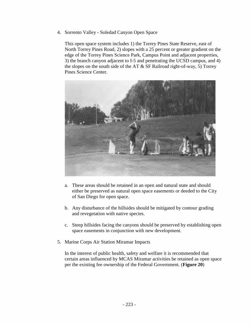
- 223 -
4. Sorrento Valley - Soledad Canyon Open Space
This open space system includes 1) the Torrey Pines State Reserve, east of North Torrey Pines Road, 2) slopes with a 25 percent or greater gradient on the edge of the Torrey Pines Science Park, Campus Point and adjacent properties, 3) the branch canyon adjacent to I-5 and penetrating the UCSD campus, and 4) the slopes on the south side of the AT & SF Railroad right-of-way, 5) Torrey Pines Science Center. a. These areas should be retained in an open and natural state and should
either be preserved as natural open space easements or deeded to the City of San Diego for open space.
b. Any disturbance of the hillsides should be mitigated by contour grading
and revegetation with native species. c. Steep hillsides facing the canyons should be preserved by establishing open
space easements in conjunction with new development.
5. Marine Corps Air Station Miramar Impacts In the interest of public health, safety and welfare it is recommended that
certain areas influenced by MCAS Miramar activities be retained as open space per the existing fee ownership of the Federal Government. (Figure 20)

- 224 -
Figure 37. Open Space Proposals
- 225 -
6. Rose Canyon
City-owned land within Rose Canyon should be preserved as dedicated open space.
a. Future uses of Rose Canyon should consider the topography, vegetation
and scenic value of the canyon. For this reason, passive recreational uses are recommended rather than active uses requiring major grading and construction.
b. Pedestrian and bicycle paths should be constructed as illustrated in
Figure 11 of the Transportation Element and in the Urban Design Element.
c. The San Diego Unified School District should consider the granting of an
easement along the north side of the University City Senior High School to permit public access through Rose Canyon and under the railroad track to the north.
d. An open space easement with access permitted should be granted along the
north side of the AT & SF Railroad between I-5 and I-805.
e. Developments along the northern edge of Rose Canyon should provide open space easements bordering the canyon. If grading within the easements is required for development, the final grading and revegetation should blend with the natural canyon features. The existing open space easement between Regents Road and Genesee Avenue should be maintained; access rights should be acquired to permit pedestrian and bicycle paths linking this area with Rose Canyon.
f. If a linkage can be made to an equestrian center outside the community, an
equestrian trail could be developed in Rose Canyon in accordance with the adopted Plan for Equestrian Trails and Facilities. No developments or staging areas are proposed by this designation.
7. San Clemente Canyon
Marian Bear Park should be preserved and maintained by the City of San Diego as a regional, resource-based park. The canyon and its riparian vegetation, including the mature oak and sycamore trees, should be preserved in their natural state.
a. Pedestrian bicycle paths should be constructed to connect Standley Park
and Marian Bear Park, utilizing the existing SR-52 undercrossing.
- 226 -
b. Three branches of the canyon which extend northward into South University should be preserved as open space by retaining existing open space easements. These areas include 19.47 acres between Stadium Street and Tulane Street, approximately three acres west of Kantor Street and 15.47 acres east of Gullstrand Street, developed as a golf course.
8. Gilman Drive Slopes
The slopes along Gilman Drive between I-5 and Via Alicante should be preserved as undeveloped open space. In addition, properties bordering Gilman Drive should provide a visual extension of the open space corridor north from Via Alicante to La Jolla Village Drive. Landscaping and site design on private properties abutting the street and adjacent to the canyon should enhance the visual quality and continuity of this open space corridor. An existing partial bike lane should be continued to connect the UCSD with the Rose Canyon bikeway via Gilman Drive.
B. Population-Based Parks
1. Summary of Proposed Facilities
The University community is proposed to be served by three community parks and six neighborhood parks totaling 125 gross acres and 102.24 usable acres of park area (Table 9). Eastgate Park will be developed as a privately operated park and community recreation center open to the general public. In addition, recreational facilities at public schools should be made available for community use. University Village Park in South University is partially developed. The emphasis of this park should be on less intense recreational uses such as open play lawns and picnic facilities. The public park facilities are illustrated on Figure 24.
2. Community Park
A community park is provided on approximately 26 acres, adjacent to and north of Doyle Elementary School. The improvements include ball fields, multipurpose courts, tiny tot lots, open play and picnic areas and a recreation building. The North University City Public Facilities Financing Plan and Facilities Benefit Assessment provided for site acquisition, design and development of this park and construction of a recreation building.
3. Sports Field Complex (Nobel Athletic Area)
A sports field complex (designated as a community facility) should be developed on approximately thirty two-acres in the vicinity of I-805 and Nobel Drive. The athletic area will provide for sport fields, a recreation center, library, and passive recreation. Funding will be provided by the Facilities Benefit Assessment (FBA).
- 227 -
4. General Plan Standards
The General Plan indicates that population-based parks should consist of one community park for each 25,000 persons and one neighborhood park for each 5,000 persons. (The community park is also the neighborhood park for the area in which it is located.) Depending on their location with respect to schools, the community parks are to consist of 13 to 20 acres while the neighborhood parks are described as five to ten acres. Thus, the General Plan Standards for acreage for population-based park acreage varies between 1.32 and 2.4 acres per thousand depending upon whether all or none of the park sites are adjacent to school.
According to the Progress Guide and General Plan guidelines for population- base parks the University community, with a population of 62,176 residents should be served by a total of approximately three community parks, of 20 usable acres each, and 13 neighborhood parks of 10 usable acres each, unless adjacent to a school, where joint use of the playfields is possible (Table 9). Population-based park acres should total 176 usable acres, taking into account the joint use of adjacent schools. As indicated in Table 9, the existing population-based park acreage is 102.24 usable acres, a shortfall of approximately 50 usable acres. The existing facilities result in approximately 1.59 acres of usable parkland per 1000 residents. This shortfall in population-based parks is mitigated by the resource-based parks located in or adjacent to the community totaling over 2,183 acres. Three of the population-based parks are also adjacent to schools, enabling the school sports field to be used in conjunction with the parks. Although they cannot be counted towards the population-based park acreage, these leased areas also mitigated the identified shortage.
Further mitigation of the population-based neighborhood park shortage in the University community should be accomplished by the provision of private recreation areas in planned residential developments (PRDs). The role of PRDs in providing this open space is addressed below.
5. Use of School Facilities
Recreational facilities at the City public schools should be made available for community-wide use. School sports fields and courts should complement and contribute to the recreational potential adjacent neighborhood parks.
C. Other Recreational Facilities
1. University Recreation

- 228 -
The University of California should be encouraged to develop recreational facilities, pedestrian paths and bike lanes which in addition to accommodating its needs, complement open space uses in the Plan area and integrate UCSD more fully with the community.
2. Planned Residential Developments
Major planned residential developments proposed in the North University area should include recreational facilities and open space areas as key elements in the project design. These private recreational areas should provide enough usable open space to compensate for a lack of neighborhood parks within walking distance of most residences. The private open space areas should connect to the extent feasible with adjacent open space canyons and the overall park and open space system of the plan area.
3. Commercial Recreation
Private commercial development should contribute to the recreational opportunities of the community.
D. Open Space Connections
1. Linkage System
An open space trails linkage system should be implemented to connect the major canyons with the neighborhood parks, schools and private open space areas. Pedestrian pathways and bicycle lanes should also connect recreational areas with major activity centers such as the town center core and UCSD. The backbone of the proposed trail system and bicycle routes is illustrated in Figure 11 in the Transportation Element and in the Urban Design Element. Consideration should also be given to the utilization of utility easements as trail linkages.
2. Private Open Space
Open spaces within residential or commercial developments should be linked, wherever feasible, to nearby parks or open space canyons. The design of the projects should encourage access to recreational areas by means of pedestrian and bicycle movement.
E. Hillside Development
Development within canyon bottoms and on slopes with greater than 25 percent gradients should be strongly discouraged. However, if development does occur on canyon bottoms, along bluffs or on steep slopes, the following guidelines should be followed:

- 229 -
1. Planned Residential, Commercial and Industrial Developments
It is recommended that planned developments be used in developing hillsides to permit clustering the structures on the more level areas and to reduce grading.
2. Grading Principles
In steep terrain, padded areas should be made in smaller increments to minimize bank height and level areas should be created more by building structures than by grading. The creation of standard, level building pads should be avoided. As a general guideline, only a small portion (ten percent) of the slopes with 25 percent or greater gradients should be graded.
3. Vegetation
Except as necessary to provide adequate fire buffers around structures, the natural vegetation on slopes should be retained. Disturbed slopes should be revegetated with native flora.
4. Coastal Development
Development, alteration or grading of natural landforms should not occur along bluffs or cliffs, within drainage canyons or on slopes of 25 percent or greater in the Coastal Zone in order to prevent erosion and to protect existing native plant communities and visual resources.
5. Visual Impacts
The design of hillside developments should relate to the existing topography and should be compatible with the scale and character of surrounding development. Attention should be given to building scale, roof design, materials and color. Visual access to open space areas from public roadways should be maintained.
6. Safety
Development on slopes or near bluffs should not contribute to erosion or geologic instability of the site or adjacent properties. A detailed drainage plan should be required for all new bluff-top development. Any geologic constraints to development should be identified prior to project approval.
7. Use and Future Standards Each open space area can serve a variety of functions beyond the more readily
apparent primary uses. The multiple functions of the major open space areas in the community are summarized in Table 10. These functions should be considered when determining future uses of the open space areas and when determining the design and type of adjacent development.
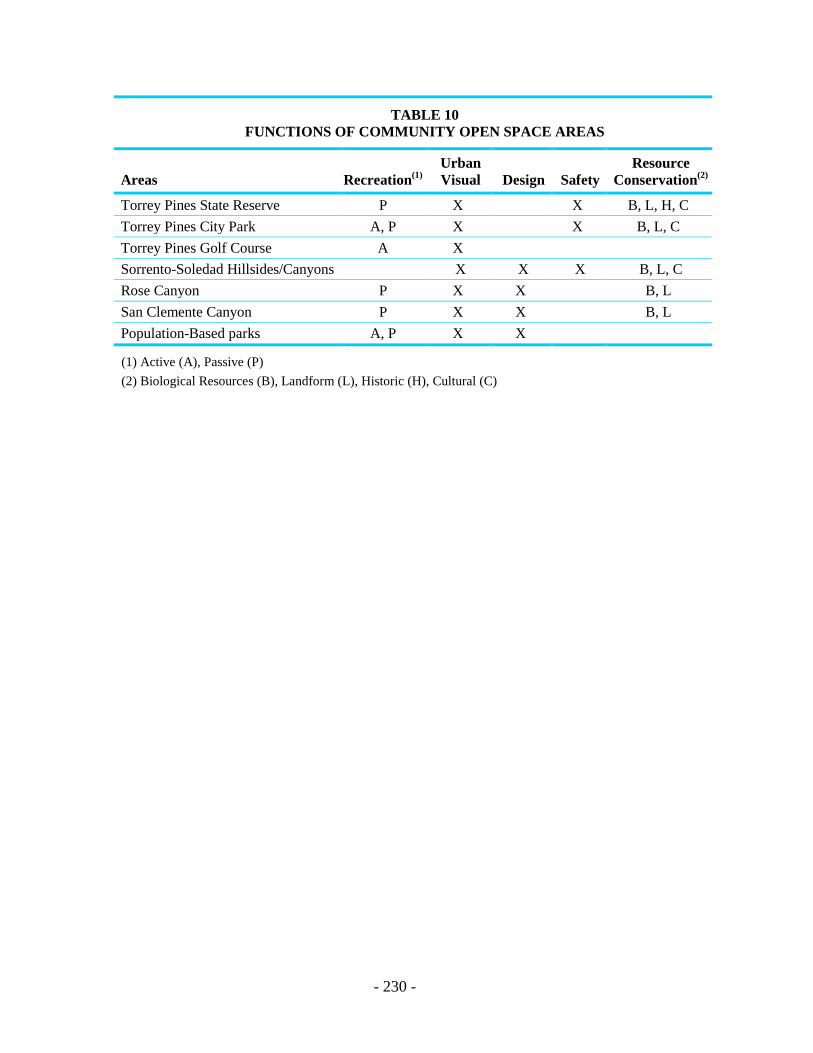
- 230 -
TABLE 10 FUNCTIONS OF COMMUNITY OPEN SPACE AREAS
Areas Recreation(1) Urban Visual Design Safety
Resource Conservation(2)
Torrey Pines State Reserve P X X B, L, H, C Torrey Pines City Park A, P X X B, L, C Torrey Pines Golf Course A X Sorrento-Soledad Hillsides/Canyons X X X B, L, C Rose Canyon P X X B, L San Clemente Canyon P X X B, L Population-Based parks A, P X X
(1) Active (A), Passive (P) (2) Biological Resources (B), Landform (L), Historic (H), Cultural (C)

Noise Element

- 233 -
NOISE ELEMENT I. EXISTING CONDITIONS
Significant noise impacts within the University community are primarily caused by transportation functions. The three transportation noise sources in the community are aircraft from MCAS Miramar, vehicles on major roadways and railroad trains along the AT & SF Railroad. The appropriate planning of land use and sensitive project design can minimize noise impacts and provide a more pleasant and productive human environment.
A. Marine Corps Air Station Miramar
Aircraft operations using the Seawolf Departure from MCAS Miramar create noise levels within the University community that reach as high as 75 decibels (CNEL). The Airport Land Use Compatibility Plan has noise contours and a compatibility matrix for aircraft produced noise impacts. Noise levels from MCAS Miramar exceeding 65 decibels impact the northern and eastern portions of the University community. The most severe noise levels, up to 75 decibels, impact the land along Eastgate Mall and Miramar Road east of I-805.
The land in this area consists of level mesas, partially developed in industrial land uses, and the slopes along Soledad Canyon and Sorrento Valley. The only existing land uses which are incompatible with the Airport Land Use Compatibility Plan are the residential units near the eastern edge of South University and the Torrey Pines Inn. Both of these developments were approved prior to the establishment of aircraft noise compatibility standards.
B. Surface Vehicular Noise
Vehicular traffic along major roadways in the community also generates noise levels exceeding 65 decibels. The area impacted by noise will generally increase as the community develops and traffic volumes approach future projections.

- 234 -
Figure 38. Deleted

- 235 -
Figure 39. Deleted
- 236 -
AIRPORT NOISE/LAND USE COMPATIBILITY IMPLEMENTATION DIRECTIVES The noise and overflight policies and criteria contained in the Airport Land Use Compatibility Plan are addressed in the General Plan (Noise Element) and implemented by the supplemental development regulations in the Airport Land Use Compatibility Overlay Zone within Chapter 13 of the San Diego Municipal Code. Planning efforts need to address airport land use compatibility issues consistent with airport land use compatibility policies and regulations. Primary sources of roadway noise will include I-5, I-805, SR-52, La Jolla Village Drive, Nobel Drive, Genesee Avenue, Regents Road, Eastgate Mall, Miramar Road and North Torrey Pines Road. The Atchinson, Topeka and Santa Fe Railroad is a source of intermittent noise along Rose Canyon and Sorrento Valley. Peak noise levels from trains can exceed 85 decibels at 100 feet from the track. Noise levels currently do not exceed 65 decibels as close as 25 feet from the track because of the intermittent nature of the noise. However, if the number of trains per day increases substantially in the future, the railroad could result in significant noise impacts to adjacent properties. I. GOALS
A. Minimize and avoid adverse noise impacts by planning for the appropriate placement and intensity of land uses relative to noise sources.
B. Provide guidelines for the mitigation of noise impacts where incompatible land
uses are located in a high noise environment. II. PROPOSALS
A. The development of land uses incompatible with the Airport Land Use Compatibility Plan should be prohibited. The Plan proposes that much of the area impacted by this noise source be developed with industrial and scientific research uses or retained as open space.
B. Encourage and where possible assist the Federal Government in its acquisition of
land or easements surrounding MCAS Miramar to ensure that the land uses are compatible with noise from airport operations.
C. Mitigation measures should be evaluated for their effectiveness, visual impact,
energy efficiency and economic efficiency.
- 237 -
1. Projects impacted by roadway noise or point sources should be carefully designed so that building orientation, placement of windows and other design features will minimize noise impacts.
2. Residential development along the freeways should be sufficiently buffered
from vehicular noise by means of setbacks or elevation differences wherever feasible, to avoid the use of solid walls as mitigation. Some of these buffers along the freeways or major roads could be used for compatible uses, such as pedestrian pathways or bikeways and linear parks.
3. Where solid walls are necessary to mitigate noise impacts along roadways, the
design of the wall and surrounding land should soften the visual effect of the wall. A site-sensitive wall design should be combined with landscaping and berms to enhance the visual quality of the wall.
4. Mechanical ventilation should be installed in residential developments to
supplement or replace air conditioning in situations where interior insulation is the chief means of reducing noise impacts.


Safety Element

- 241 -
SAFETY ELEMENT Two safety hazards within the University community include geologic hazards and the accident potential from aircraft operations at MCAS Miramar. This element identifies the locations of these hazards and provides guidelines to maximize public safety.
I. EXISTING CONDITIONS
A. Geologic Hazards
Geologic risks within The City of San Diego have been mapped in the Seismic Safety Study for The City of San Diego by Woodward-Gizienski & Assoclates and F.B. Leighton & Associates (May 1974). This study indicates potential locations for faults, unstable slopes, ground failures, unstable coastal bluffs and other terrain conditions. Geologic hazards within the University community are illustrated on Figure 40 and are summarized below: 1. Faults
The closest known fault system that appears capable of generating a damaging earthquake is the Rose Canyon Fault Zone, located southwest of the community. Several faults within this zone are considered potentially active and a high risk. The only other potentially active fault in the area is the Carmel Valley Fault, located on the Torrey Pines State Reserve and adjacent properties. Several faults also cross North University, primarily in the Torrey Pines Fault Zone. These faults are considered inactive and a moderate safety risk.
2. Landslides and Slope Instability
Old landslides and landslide-prone formations are the principal non-seismic geologic hazards within the community. Conditions that contribute to slope instability include slope inclination, rock orientation of the bedding, soil characteristics, and the presence of groundwater.
Slopes with a moderate or high risk of slope failure occur along the coastal bluffs and canyons west of Torrey Pines mesa and along the south side of Sorrento Valley. Some slopes along Rose Canyon and San Clemente Canyon have a moderate or high risk of landslides. In addition, many localized landslide areas of high risk occur throughout the Plan area.
3. Coastal Bluff Instability
The coastal bluffs west of Torrey Pines Mesa are highly unstable because joints and fractures inherent in the formation material are weakened by erosion

- 242 -
from mesa-top runoff and groundwater seepage. Landslides, block falls and talus failures are among the identified hazards.
4. Flooding and Liquefication
The only locations in the community subject to inundation during a 100-year frequency flood are the lower portions of Rose Canyon and San Clemente Canyon. These areas will be retained as open space by either City ownership or easements so flooding impacts on development are not expected. The potential for damage caused by liquefication is considered to be low in these drainages and would not represent a constraint to land use.
B. Marine Corps Air Station Miramar
A portion of the University community is impacted by the aircraft accident potential from MCAS Miramar. Departures to the west along the Seawolf Departure create a safety hazard for the areas along Eastgate Mall, Miramar Road, Sorrento Valley and adjacent slopes and the Torrey Pines mesa. The MCAS Miramar Airport Land Use Compatibility Plan delineates the boundaries of the Safety Zones (Accident Potential Zone I and II and a Transitional Zone and the Airspace Protection Area). The Airport Land Use Compatibility Plan defines the types of land uses which are compatible with the Safety Zones. Further, the Federal Government has purchased in fee those properties which are most critical to the maintenance of a safe departure corridor.
II. GOALS
A. Protect the public health and safety by guiding future development so that land use is compatible with identified geologic risks, including seismic and landslide hazards.
B. Ensure that proposed development does not create or increase geologic hazards
either on- or off-site.
C. Promote public safety by taking into account aircraft accident potential in the placement of structures and activities.
D. Provide for the safe operation of MCAS Miramar through the preservation of
appropriate departure corridors.

- 243 -
Figure 40. Geologic Hazards

- 244 -
Figure 41. Deleted

- 245 -
Figure 42. Deleted
- 246 -
III. PROPOSALS
A. Geologic Hazards
1. Geologic Studies
When geologic hazards are known or suspected, a geologic reconnaissance should be performed prior to project approval to identify development constraints. This requirement would supplement the need for a full geo-technical report, which may be required at a later time in the permit process.
2. Hydrology
Maintain the natural drainage system and minimize the use of impervious surfaces. Concentrations of runoff should be adequately controlled to prevent an increase in downstream erosion. Irrigation systems should be properly designed to avoid over-watering.
3. Vegetation
Native vegetation should be retained where possible. Graded slopes should be revegetated with native or drought-tolerant species to restore pre-development drainage conditions.
4. Torrey Pines City Park
Any future improvements to the City park should be designed to promote public safety and minimize further bluff damage. Pedestrian walkways and other improvements along the bluffs should be placed so as to avoid and prevent bluff instability hazards.
B. Marine Corps Air Station Miramar
1. Compatible Land Uses
New projects in the community should be reviewed by the City for compatibility within the established Airport Influence Area as delineated in the Airport Land Use Compatibility Plan for MCAS Miramar. Where Federal Government easements are used to control development coverage, height limitations or specific uses, such easements should be considered as providing adequate assurance of compatibility with aircraft accident potential. In all cases, it will be the intention of the City of San Diego to work with the Airport Land Use Commission and MCAS Miramar in the implementation of the Airport Land Use Compatibility Plan.

- 247 -
2. Land Use Control
Encourage the fee simple acquisition or the purchase of easements by the Federal Government for land affected by the aircraft accident potential. The safety and airspace protection policies and criteria contained in the Airport Land Use Compatibility Plan are addressed in the General Plan (Land Use and Community Planning Element) and implemented by the supplemental development regulations in the Airport Land Use Compatibility Overlay Zone within Chapter 13 of the San Diego Municipal Code. Planning efforts need to address airport land use compatibility issues consistent with airport land use compatibility policies and regulations. If areas currently owned by the Federal Government are released into public or private use, special studies and amendments to the community plan should be conducted prior to rezoning or development to ensure traffic and overflight compatibility.

THIS PAGE INTENTIONALLY LEFT BLANK.
Resource Management Element


- 251 -
RESOURCE MANAGEMENT ELEMENT I. INTRODUCTION
The resources in the University community are both abundant and highly valuable, due in part to the area’s variable topography, undeveloped open spaces and location near the ocean and other water sources. The preservation and enhancement of these resources contributes to the attractiveness and interest of the community. The resources can also have regional and even national significance. For these reasons, the conservation and preservation of the community’s resources should be an integral part of future development.
II. EXISTING CONDITIONS
A. Natural Resources
The natural resources in the community consist primarily of topographic features, such as hillsides and bluffs, biological resources and fossil remains. Imported resources include energy and water supplies. The community does not possess any significant agricultural land, mineral deposits or sources of sand and gravel.
1. Topographic Features
The canyons, hillsides, bluffs and other unique landforms provide visual amenities which separate and define urban areas and impart a unique character to the community. The area’s steepest slopes occur along the coastline, on the south side of Sorrento Valley and along the southern slopes of Rose Canyon and San Clemente Canyon. The bluffs along the coast at the Torrey Pines State Reserve and Torrey Pines City Park provide spectacular views. These bluffs, together with the coastal canyons and distinct vegetation, constitute a regional resource of great value. In addition, the wide valley floors and adjacent hillsides of Rose Canyon and San Clemente Canyon provide a unique character to the adjacent neighborhoods and to the community as a whole.
2. Biology
The area’s biological resources coincide with the areas of topographic interest. Rose Canyon and San Clemente Canyon contain riparian vegetation, consisting of oak and sycamore trees with associated undergrowth. The north-facing canyon slopes are vegetated with dense stands of chaparral while more open vegetation and grasslands occur on the drier, south-facing slopes. Similarly, the hillsides along Sorrento Valley contain valuable stands of native vegetation. Areas near Eastgate Mall east of I-805 contain some vernal pool resources.
- 252 -
The Torrey Pines mesa, coastal canyons and bluffs as well as the slopes and mesas bordering Peñasquitos Lagoon contain a unique assemblage of plant species. The Torrey Pine tree is endemic to California and is considered to be an important native resource for both aesthetic and biological reasons. In addition, many other sensitive plant species occur in the area. A variety of vegetation associations are located here, including several types of native chaparral associations, coastal sage scrub and inland sage scrub.
3. Coastal Resources The University community includes over 14,000 feet of shoreline, most of which consists of a sandy beach bordered by sheer cliffs or relatively undisturbed coastal canyons. The City of San Diego owns a 1,000-foot-long strip of beach, located below the southern portion of the Torrey Pines City Park. The remainder of the beach area within the community is owned by the State of California as part of the Torrey Pines State Reserve.
Beach access is currently available from a parking area north of the State Reserve along North Torrey Pines Road. Pedestrian and emergency vehicle access is also available by means of a paved road owned by the University of California, located in Black Canyon off La Jolla Farms Road. Additionally, pedestrians have been reaching the beach area by following trails down the cliffs and canyons at the Torrey Pines City Park and, to a lesser degree, at the Torrey Pines State Reserve.
4. Paleontology
Recovery of fossil remains can aid in the documentation of the last 150 million years of earth history. Several areas within the City of San Diego contain accessible paleontological resources. Although no specific areas within the University community are known to have produced significant paleontological resources, the community contains several geological rock units that have recognized resource potential. The lack of significant finds in the community thus far may be due to the relative lack of disturbance of the formations in which fossil resources occur.
In the University community, the most abundant geologic formations containing fossils include the Scripps Formation and Ardath Shale. The Scripps Formation includes marine sediments and has a “medium” resource potential. The Ardath Shale contains some important marine invertebrate fossils and the resource potential is considered to be “medium to high.” The Bay Point Formation and Stadium Conglomerate occur near the future surface in a few isolated locations in the planning area, and these geologic units have a “low to medium” resource potential.
- 253 -
The Scripps Formation and Ardath Shale are relatively common near the surface of the major slopes in the University community. These formations occur along the coastline, on the slopes bordering San Clemente and Rose Canyons and on adjacent finger canyons. Most of the Villa La Jolla area and slopes bordering I-5 also have these geologic formations near the ground surface.
5. Energy and Water Supplies
While existing service to the region is adequate, energy and water are regional resources in limited supply. Conservation practices will probably become increasingly important in the future to supply the San Diego area with adequate quantities at affordable prices. The contribution of each community to this conservation of energy and water should be assured at the planning stage of development in order to best implement conservation measures.
6. Cultural Resources
Cultural resources are physical features associated with human activity. The features can be either natural or man-made and include such things as buildings, signs, planted material, rock art, burial grounds or almost anything that indicates the past presence of humans. A records search for archaeological sites has been conducted by the San Diego Museum of Man for the University community planning area (May 10, 1982). Over 50 sites have been recorded in the University community. The majority of the sites occur along the mesa areas overlooking Sorrento Valley and on the Torrey Pines Mesa. Several sites have also been recorded on the UCSD campus.
The recorded finds may vary greatly in their resource value, ranging from isolated artifacts to sites of regional significance. Many of the sites are adjacent to the archaeological resources in Sorrento Valley, which have been considered for listing on the National Register of Historic Places. Therefore, resources within the University community may have significance on a regional scale and could aid in interpreting data gathered from adjacent communities.
7. Air Quality The University community is located in the San Diego Air Basin/San Diego County, which has been classified as a non-attainment area for the pollutants of carbon monoxide, ozone, and particulates. The County is an attainment area for nitrogen dioxide. Ozone, carbon monoxide, and particulates are considered to be the major air quality problems in San Diego. The most significant source of air pollution in the San Diego Basin is automobile emissions. There are no known stationary sources in the University community which significantly impact air quality.

- 254 -
III. GOALS
A. Preserve the community’s natural topography, particularly in the coastal zone and in major canyon systems.
B. Increase accessibility to the beaches and shoreline in a manner compatible with
resources preservation.
C. Protect biological resources through the wise management and use of community’s natural open space and parks.
D. Contribute to the maintenance or improvement of regional water quality by
controlling siltation and urban pollutants in runoff. E. Encourage the conservation of water in the design and construction of buildings
and in landscaping. F. Reduce energy consumption by requiring energy efficiency in building design and
landscaping and by planning for a self-contained community and energy-efficient transportation.
G. Provide for the identification and recovery of significant paleontological resources.
H. Ensure the effective preservation and management of significant archaeological
and historic resources. IV. PROPOSALS
A. Natural resources
1. Landform Preservation
Canyons, hillsides and natural drainage systems should be preserved. Grading should be kept to a minimum, particularly adjacent to designated open space areas. Specific proposals for development of resource-based parks and hillside development are contained in the Open Space and Recreation Element.
2. Biological Resources
Many of the community’s biological resources are proposed for preservation in natural parks, as specifically addressed in the Open Space and Recreation Element. In other areas, native vegetation should be retained wherever feasible to reduce erosion, to preserve native species and representative habitats and to buffer open space parks and canyons from urban encroachment. Disturbed areas should be revegetated with native flora.
- 255 -
3. Water Quality/Erosion
Development should minimize erosion and sedimentation. If a project site is on or adjacent to sloping lands, drainage systems should be designed so that the peak rate of runoff for the ten-year-frequency storm event will not exceed the rate under undeveloped conditions. Runoff control should be accomplished by catchment basins, siltation traps, or detention basins along with energy dissipating measures or by other methods which are equally effective. Grading during the rainy season should be avoided wherever possible. Erosion should be minimized by grading in increments during the rainy season and by using temporary erosion control measures. In areas where grading is completed, all disturbed slopes should be stabilized by vegetation or other means prior to the rainy season.
4. Water Conservation
Building construction should incorporate equipment or devices with low water requirements. Landscaping plans should utilize drought-tolerant plants and efficient watering systems. In addition, as health laws allow, “Gray Water” or water reuse systems should be explored for application within the community.
5. Energy Conservation
Development plans should be reviewed for energy conserving features. Site design should maximize opportunities for active and passive heating and cooling by means of appropriate building orientation, solar access and landscaping. If a proposed development would impact solar energy systems off-site, compensating measures should be included in project plans.
Commercial and industrial developments should incorporate measures to increase energy-efficient forms of transportation by supplying bicycle racks, showers, priority parking for car pools, bus stops with support facilities and other incentives.
6. Air Quality
The City of San Diego cooperated with citizens and other governmental entities in developing the Regional Air Quality Strategy (RAQS) to comply with Federal requirements of the 1977 Clean Air Act and is committed to implementing the RAQS as a regional policy. The transportation tactics included in the RAQS are for the most part implemented by proposals included in the University Community Plan. In addition, traffic flow improvements intended to smooth traffic flow on arterial streets and reduce hydrocarbon and carbon monoxide emissions by reduction in idling time at intersections and at points of traffic congestion should be implemented. To implement this tactic

- 256 -
streets and intersections should be designed and traffic lights adjusted to maximize the smooth flow of traffic.
B. Cultural Resources
1. Paleontology
Although many areas with a moderate to high potential for fossil remains coincide with designated open space, resources may be lost by grading activities associated with development. Impacts to paleontological resources should be identified and mitigated, if necessary, through the environmental review process.
2. Cultural Resources
Potential impacts to archaeological resources should be identified during the permit process. If the impact of the proposed development is determined to be significant, mitigation measures should be determined by a qualified archaeologist and required as a part of project approval.

General Plan Consistency Element


- 259 -
GENERAL PLAN CONSISTENCY ELEMENT I. INTRODUCTION
As part of the update of the Plan, specific recommendations have been included to implement the goals and objectives of the General Plan. This Plan contains a number of recommendations which help to meet General Plan goals in the areas of industrial development, commercial development, transportation, housing, urban design and conservation. Outlined below are proposed actions which help to implement or otherwise affect General Plan goals:
II. INDUSTRIAL DEVELOPMENT
This Plan proposes three types of industrial development, scientific research, business park and restricted industrial. The General Plan identifies a citywide shortage of land suitable for manufacturing activities and a need to protect a reserve of manufacturing land from non-manufacturing uses. The restricted industrial designations would permit light manufacturing uses, thereby providing additional land suitable for manufacturing activities. In particular, the restricted industrial area, which is covered by Federal Government easements, would be protected from encroachment because of the limited permitted uses. The General Plan encourages the development of industrial land that is zoned and provides a full range of community services and facilities. The development of scientific research (SR zone) uses in the North Torrey Pines mesa area, Campus Point and Eastgate Technology Park is consistent with the Plan by providing support services to the University and community. Business park allows office, research and development, and light manufacturing uses. It is appropriate to apply in portions of communities primarily characterized by single-and multi-tenant office development with some light industrial uses. Adjacency to scientific research, commercial and office is compatible.
III. COMMERCIAL DEVELOPMENT
The General Plan recognizes the importance of new shopping centers which combine a mixture of uses such as: housing, retail, offices, and recreation. The high-density mixture of uses proposed for the core areas of the community (University Towne Centre and La Jolla Village Square area) are consistent with the General Plan recommendation. This Plan limits the location of commercial uses in designated industrial and scientific research areas, with the exception of support commercial uses, consistent with the General Plan recommendation regarding preemption of industrial development by non-industrial uses. Proposed neighborhood commercial development to serve the increasing residential population, and additional visitor commercial uses in the community are supportive of the General Plan recommendation to develop a balance of commercial facilities which complement existing commercial areas. This plan provides a range of commercial services including regional, community and neighborhood commercial, visitor commercial and commercial office to serve the community and city.

- 260 -
IV. TRANSPORTATION
As part of the update of this Plan the proposed street and freeway circulation system was evaluated for functional and operational improvements to increase efficiency and support citywide mass transit service, consistent with the General Plan recommendations for transportation planning. San Diego Transit Corporation’s Short Range Transit Plan, and the North University Shuttle Loop and Mid-Coast Light Rail Transit systems provide and propose community and regional transportation services which are consistent with the General Plan objective of upgraded transit through the City. This plan recommends engineering feasibility and financing studies for the community shuttle loop and alignment studies for the Mid-Coast light rail corridor as identified in the General Plan by MTDB. Existing and proposed community bicycle and pedestrian path systems are consistent with the General Plan goal of a coordinated non-motorized transportation system.
V. RESIDENTIAL DEVELOPMENT
Residential development in the University community is characterized by two types: the urbanized South University area and the planned urbanizing North University area. The existing, stable residential neighborhoods of South University City have been conserved in accordance with the General Plan goal to discourage changes to existing, well-maintained residential communities. Even though North University City is characterized by a high concentration of attached housing, the variety of housing stock supports the General Plan goal to provide affordable housing units in a balanced community. Because of the proximity to UCSD, this Plan contains density bonus incentives to assist the student housing needs, consistent with the General Plan which identifies the existence of “Special Populations” requiring housing assistance.
VI. URBAN DESIGN
As one of three urban cores in the city, the University community offers a unique opportunity by promoting high-density, innovative development with a mixture of uses. Development of the community is designed with two relatively high density cores located at University Towne Centre and La Jolla Village Square, with less development intensity proposed further from the core areas. This pattern of development is consistent with the General Plan goal to emphasize community activity centers and focal points through building design and location. Included in the elements of this Plan are guidelines for building location, size and design and special opportunities, including the preservation of view corridors and open space unique to the city. An Urban Design Element is also included in the Plan. The guidelines in the various plan elements will help implement the goals of the General Plan when used in the review of discretionary actions relating to the built environment.
- 261 -
VII. CONSERVATION
This Plan requires hillside properties with steep slopes and natural vegetation to process development permits to ensure these areas are not developed. Also, the Open Space and Recreation Element of this Plan contains development guidelines for the preservation of important canyon systems in the community. This will help implement the General Plan goal to preserve the City’s unique landforms.

THIS PAGE INTENTIONALLY LEFT BLANK.

Implementation


- 265 -
FACILITIES IMPLEMENTATION As discussed in the preface of this Plan, the implementation of the public facilities needs of the University community will be carried out in accordance with the North University City Public Facilities Financing Plan and Facilities Benefit Assessment (FBA) (Financing Plan). Council Policy 600-28 requires that, in the Planned Urbanizing areas of the City, development approval depends upon adoption of a plan for financing public facilities. To fulfill this requirement, the community’s Financing Plan contains a development forecast and analysis, a summary of existing conditions, a Capital Improvement Program (CIP) listing public facility needs and an analysis of proposed and recommended methods of financing. Facilities Benefit Assessments (FBA) are the method of financing non-subdivided public facility needs as indicated in this Plan and the Financing Plan. The assessment is based upon the costs of public facility needs, and fair and equitable distribution of those costs over the designated area of benefit in North University City. A key factor in the implementation of public facilities is the scheduling of the improvements to ensure the community buildout is supported by required public facilities. A phasing plan, which is part of the Financing Plan, ensures that facilities are provided at their time of need. In addition to the Council Policy referenced above, Council Policy 600-34 states that it shall be the policy of the City Council to work closely with the MTDB in planning for, and implementing the development of public transit in the San Diego area. More specifically it states that the City shall pursue implementing measures in the areas of planning; right-of-way protection and acquisition; and funding of guideway and facility construction, operation and maintenance. The community plan proposes two major transit improvements, the LRT system and shuttle loop, and states that right-of-way dedications, provision of transit facilities and commitments to assessment districts shall be required as conditions of approval for affected properties.
- 266 -
DEVELOPMENT CONTROLS Implementation of the community plan proposals requires effective development controls in the form of zoning, subdivision regulations, conditional use permits, planned developments, and deed restrictions. I. ZONING
Zoning may be defined as the division of the municipality into districts, and the regulation within those districts of: the use of buildings and land for residence, industry, commerce, or other purposes; the density of dwelling units; the height and/or bulk of buildings and other structures; the number of parking spaces required; the area of a lot which may be occupied; and the minimum lot dimensions.
II. SUBDIVISION REGULATIONS
Subdivision regulations govern the process of converting raw land into building sites. The process permits the coordination of many projects and assures the provision is made for the installation of utilities, the reservation or dedication of parks, street rights-of-way, school sites, open space easements, and related matters. The regulations also provide a means for controlling the internal design of each subdivision in terms of grading, lots and streets.
III. CONDITIONAL USE PERMITS
Conditional Use Permits are required for specified uses which are granted only when it has been concluded that:
A. The proposed use will not adversely affect the neighborhood, the General Plan or
the Community Plan and will not be detrimental to the health, safety or general welfare of persons residing or working in the area; and
B. The proposed use will comply with all the relevant regulations in the Municipal
Code.
IV. PLANNED DEVELOPMENT PERMITS
Planned Development Permits which include Planned Residential Developments (PRDS), Planned Commercial Developments (PCDs), and Planned Industrial Developments (PIDs) are intended to encourage imaginative and innovative development, particularly in the clustering of structures and the creation of common open space.

- 267 -
V. DEED RESTRICTIONS
Deed Restrictions are provisions of a deed which limit the use of property. Such restrictions can be especially effective in the University community, where much of the vacant land is owned by and leased from the City of San Diego.
VI. DEVELOPMENT AGREEMENTS
Development Agreements are legally binding contractual documents entered into between a local governmental unit and “any person having a legal or equitable interest in real property” for the development of that property in accordance with the terms and conditions of the “agreement.” In effect, the City agrees not to change its planning or zoning laws applicable to the development for a specified period of time, thereby, guaranteeing the developer a measure of certainty in the form of contractually obtained “vested rights.” Thus, future land use changes affecting the subject property will be made in accordance with the laws in effect when the agreement was entered into rather than when the change occurred. In return, the developer commits, for example, to construct specific improvements, provide public facilities and services, develop according to a specified time schedule or make other commitments which the City might otherwise not have authority to compel a developer to perform.
VII. COMMUNITY PLAN IMPLEMENTATION OVERLAY ZONE (CPIOZ)
The Community Plan Implementation Overlay Zone (CPIOZ) is applied to implement recommendations contained in adopted community plans. It is intended that CPIOZ be applied to properties where the underlying zoning is not capable of implementing the specific recommendations of community plans. Application of the overlay zone is limited to properties which meet one of the following criteria:
A. The site is identified in the applicable community plan with specific standards,
criteria or guidelines for the design of development or for development intensity and the site is identified as an area where specific implementing legislation is necessary; or
B. The site is identified in the applicable community plan as in area where
development in conjunction with a Planned Development Permit is recommended and where the issues to be addressed through the permit process are identified.

THIS PAGE INTENTIONALLY LEFT BLANK.

Appendix

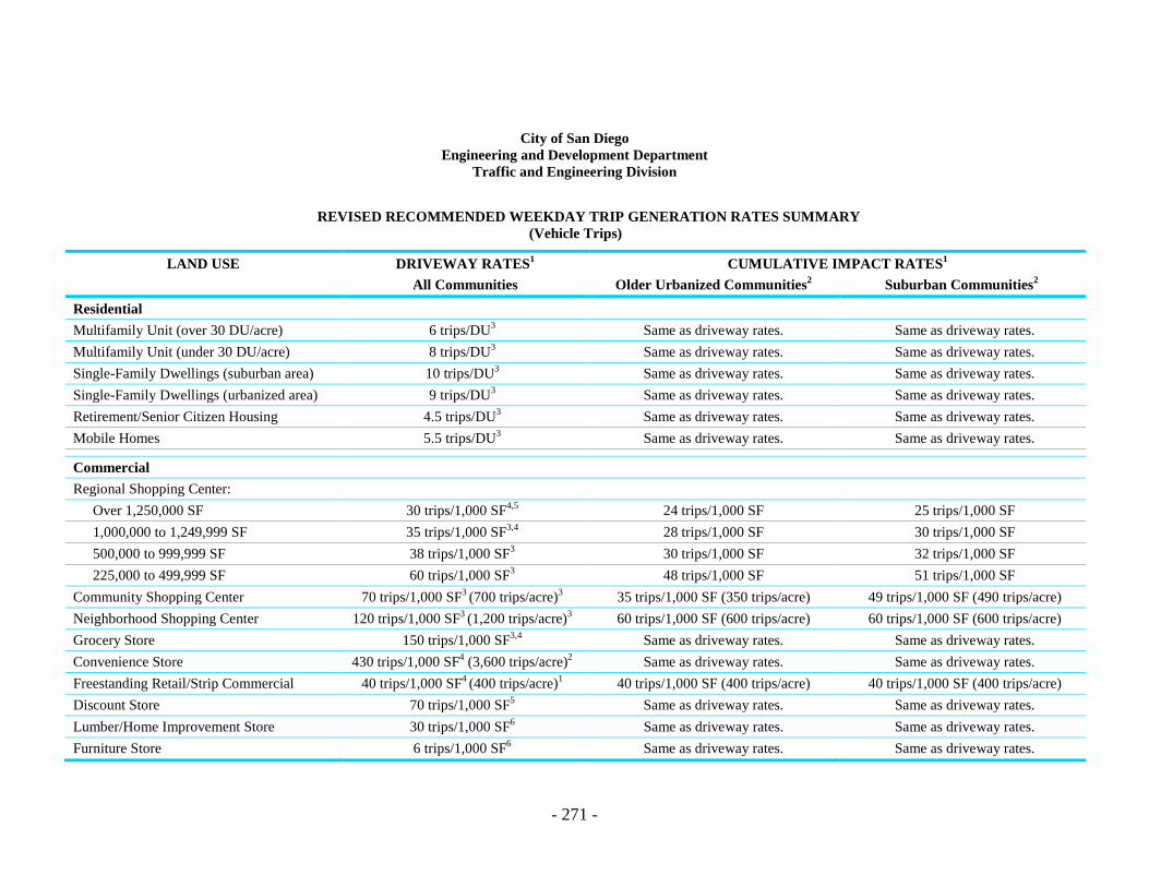
- 271 -
City of San Diego Engineering and Development Department
Traffic and Engineering Division
REVISED RECOMMENDED WEEKDAY TRIP GENERATION RATES SUMMARY (Vehicle Trips)
LAND USE DRIVEWAY RATES1 CUMULATIVE IMPACT RATES1
All Communities Older Urbanized Communities2 Suburban Communities2
Residential Multifamily Unit (over 30 DU/acre) 6 trips/DU3 Same as driveway rates. Same as driveway rates. Multifamily Unit (under 30 DU/acre) 8 trips/DU3 Same as driveway rates. Same as driveway rates. Single-Family Dwellings (suburban area) 10 trips/DU3 Same as driveway rates. Same as driveway rates. Single-Family Dwellings (urbanized area) 9 trips/DU3 Same as driveway rates. Same as driveway rates. Retirement/Senior Citizen Housing 4.5 trips/DU3 Same as driveway rates. Same as driveway rates. Mobile Homes 5.5 trips/DU3 Same as driveway rates. Same as driveway rates. Commercial Regional Shopping Center:
Over 1,250,000 SF 30 trips/1,000 SF4,5 24 trips/1,000 SF 25 trips/1,000 SF 1,000,000 to 1,249,999 SF 35 trips/1,000 SF3,4 28 trips/1,000 SF 30 trips/1,000 SF 500,000 to 999,999 SF 38 trips/1,000 SF3 30 trips/1,000 SF 32 trips/1,000 SF 225,000 to 499,999 SF 60 trips/1,000 SF3 48 trips/1,000 SF 51 trips/1,000 SF
Community Shopping Center 70 trips/1,000 SF3 (700 trips/acre)3 35 trips/1,000 SF (350 trips/acre) 49 trips/1,000 SF (490 trips/acre) Neighborhood Shopping Center 120 trips/1,000 SF3 (1,200 trips/acre)3 60 trips/1,000 SF (600 trips/acre) 60 trips/1,000 SF (600 trips/acre) Grocery Store 150 trips/1,000 SF3,4 Same as driveway rates. Same as driveway rates. Convenience Store 430 trips/1,000 SF4 (3,600 trips/acre)2 Same as driveway rates. Same as driveway rates. Freestanding Retail/Strip Commercial 40 trips/1,000 SF4 (400 trips/acre)1 40 trips/1,000 SF (400 trips/acre) 40 trips/1,000 SF (400 trips/acre) Discount Store 70 trips/1,000 SF5 Same as driveway rates. Same as driveway rates. Lumber/Home Improvement Store 30 trips/1,000 SF6 Same as driveway rates. Same as driveway rates. Furniture Store 6 trips/1,000 SF6 Same as driveway rates. Same as driveway rates.
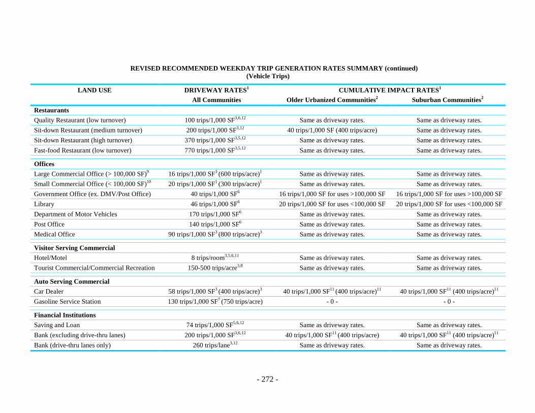
- 272 -
REVISED RECOMMENDED WEEKDAY TRIP GENERATION RATES SUMMARY (continued) (Vehicle Trips)
LAND USE DRIVEWAY RATES1 CUMULATIVE IMPACT RATES1
All Communities Older Urbanized Communities2 Suburban Communities2
Restaurants Quality Restaurant (low turnover) 100 trips/1,000 SF3,6,12 Same as driveway rates. Same as driveway rates. Sit-down Restaurant (medium turnover) 200 trips/1,000 SF3,12 40 trips/1,000 SF (400 trips/acre) Same as driveway rates. Sit-down Restaurant (high turnover) 370 trips/1,000 SF3,5,12 Same as driveway rates. Same as driveway rates. Fast-food Restaurant (low turnover) 770 trips/1,000 SF3,5,12 Same as driveway rates. Same as driveway rates. Offices Large Commercial Office (> 100,000 SF)9 16 trips/1,000 SF3 (600 trips/acre)1 Same as driveway rates. Same as driveway rates. Small Commercial Office (< 100,000 SF)10 20 trips/1,000 SF1 (300 trips/acre)1 Same as driveway rates. Same as driveway rates. Government Office (ex. DMV/Post Office) 40 trips/1,000 SF6 16 trips/1,000 SF for uses >100,000 SF 16 trips/1,000 SF for uses >100,000 SF Library 46 trips/1,000 SF6 20 trips/1,000 SF for uses <100,000 SF 20 trips/1,000 SF for uses <100,000 SF Department of Motor Vehicles 170 trips/1,000 SF6 Same as driveway rates. Same as driveway rates. Post Office 140 trips/1,000 SF6 Same as driveway rates. Same as driveway rates. Medical Office 90 trips/1,000 SF3 (800 trips/acre)3 Same as driveway rates. Same as driveway rates. Visitor Serving Commercial Hotel/Motel 8 trips/room3,5,6,11 Same as driveway rates. Same as driveway rates. Tourist Commercial/Commercial Recreation 150-500 trips/acre3,8 Same as driveway rates. Same as driveway rates. Auto Serving Commercial Car Dealer 58 trips/1,000 SF3 (400 trips/acre)3 40 trips/1,000 SF11 (400 trips/acre)11 40 trips/1,000 SF11 (400 trips/acre)11
Gasoline Service Station 130 trips/1,000 SF7 (750 trips/acre) - 0 - - 0 - Financial Institutions Saving and Loan 74 trips/1,000 SF5,6,12 Same as driveway rates. Same as driveway rates. Bank (excluding drive-thru lanes) 200 trips/1,000 SF3,6,12 40 trips/1,000 SF11 (400 trips/acre) 40 trips/1,000 SF11 (400 trips/acre)11
Bank (drive-thru lanes only) 260 trips/lane3,12 Same as driveway rates. Same as driveway rates.

- 273 -
REVISED RECOMMENDED WEEKDAY TRIP GENERATION RATES SUMMARY (continued) (Vehicle Trips)
LAND USE DRIVEWAY RATES1 CUMULATIVE IMPACT RATES1
All Communities Older Urbanized Communities2 Suburban Communities2
Cemetery 5 trips/acre3 Same as driveway rates. Same as driveway rates. Airports General Aviation Airport 2 trips/average daily flight3 Same as driveway rates. Same as driveway rates. Industrial Large Industrial9 8 trips/1,000 SF3 (100 trips/acre) Same as driveway rates. Same as driveway rates. Small Industrial10 14 trips/1,000 SF3 (130 trips/acre) Same as driveway rates. Same as driveway rates. Large Industrial/Business Park9 12 trips/1,000 SF3 Same as driveway rates. Same as driveway rates. Small Industrial/Business Park10 18 trips/1,000 SF3 (200 trips/acre)3 Same as driveway rates. Same as driveway rates. Scientific Research and Development10 8 trips/1,000 SF3 (85 trips/acre)3 Same as driveway rates. Same as driveway rates. Warehousing 5 trips/1,000 SF5 (80 trips/acre)6 Same as driveway rates. Same as driveway rates. Corporate Headquarters 9 trips/1,000 SF3 (149 trips/acre)3 Same as driveway rates. Same as driveway rates. Rental Storage 2 trips/100 SF3 (0.2 trips/storage vault)3 Same as driveway rates. Same as driveway rates. Truck Terminal 60 trips/acre Same as driveway rates. Same as driveway rates. Institutional House of Worship (Church or Synagogue) 60 trips/acre6 (300 trips/each)6 Same as driveway rates. Same as driveway rates. Military Base 2.5 trips/military/civilian employee Same as driveway rates. Same as driveway rates. Hospital 20 trips/bed3 Same as driveway rates. Same as driveway rates. Convalescent Hospital 3 trips/bed4 Same as driveway rates. Same as driveway rates. Educational Four-year University or College 2.8 trips/student3 Same as driveway rates. Same as driveway rates. Two-year College (Junior College) 1.5 trips/student3 Same as driveway rates. Same as driveway rates. High School (Secondary School) 1.5 trips/student3 Same as driveway rates. Same as driveway rates. Junior High School (Middle School) 1.0 trips/student3,4 Same as driveway rates. Same as driveway rates. Elementary School (Grade School) 1.4 trips/student3 Same as driveway rates. Same as driveway rates.

- 274 -
REVISED RECOMMENDED WEEKDAY TRIP GENERATION RATES SUMMARY (continued) (Vehicle Trips)
LAND USE DRIVEWAY RATES1 CUMULATIVE IMPACT RATES1
All Communities Older Urbanized Communities2 Suburban Communities2
Recreational Park (undeveloped) 5 trips/acre3 Same as driveway rates. Same as driveway rates. Park (developed) 40 trips/acre3 Same as driveway rates. Same as driveway rates. Golf Course 6 trips/acre6 Same as driveway rates. Same as driveway rates. Bay and Ocean Beaches/Park 1000 trips/1000 feet shore3 (70 trips/acre) Same as driveway rates. Same as driveway rates. Lake (with boating) 50 trips/1000 feet shore3 (6 trips/acre) Same as driveway rates. Same as driveway rates. Zoo or Sea Life Park 100 trips/acre3 Same as driveway rates. Same as driveway rates. Marina 4 trips/berth3 Same as driveway rates. Same as driveway rates. Sports Facility 1 trip/attendee3 (42 trips/acre)3 Same as driveway rates. Same as driveway rates. Racquetball/Tennis/Health Club 40 trips/court3 (45 trips/1,000 SF)3 Same as driveway rates. Same as driveway rates. Theaters 1.8 trips/seat (800 trips/acre) Same as driveway rates. Same as driveway rates.
(1) “Driveway rates” apply when the effect of passerby trips is irrelevant such as when the project entrance (and any distance beyond per the Transportation and Traffic Engineering
Division) are being analyzed. This may result with either a manual, non-computerized study or a computerized study (see DI). Use of the driveway rates for project-specific impacts near its entrance does not necessarily preclude the use of the cumulative trip rates for analyzing the effects on the community street system. Guidance can be obtained from the Transportation and Traffic Engineering Division staff in each situation.
(2) See “List of Older Urbanized Communities and Suburban Communities for Trip Generation Responses.” Also see “Figure of Suburban Communities for Trip Generations.” (3) SANDAG/Caltrans, San Diego Traffic Generators (1971–1986, including studies not yet published). (4) Arizona Department of Transportation, Trip Generation Intensity Factors (1/1/79 version). (5) I.T.E., Trip Generation (1982). (6) Caltrans District 4, Trip Ends Generation Research Counts (1975-1982). (7) COMSIS, Quick Response Urban Travel Estimation Techniques and Transferable Parameters, NCHRP Report #187 (1978) (8) A range is shown due to the wide variety of land uses associated with this category. See the “Definitions of Land Use Categories for Trip Generation Purposes” for additional
information. (9) “Large” is applicable where buildings are over 100,000 SF or where parcels are over 8 acres in size. (10) “Small” is applicable where buildings are under 100,000 SF or where parcels are under 8 acres in size. (11) Included in hotel/motel trip generation rates is a citywide vacancy rate of 24.6 percent. (12) The restaurants and financial institutions rates shown apply to freestanding facilities only. If any of these uses are part of a larger project (e.g., an office building or a shopping
center) they would have the same rate as the larger project has.