Embed Size (px)
Citation preview
1
Chapter 6
CITYDATA &Richmond’s Data Dissemination
Strategy
2
What is CITYDATA?
• It is a City of Richmond Standard for distributing GIS data and functionality.
• It is an ArcMap Extension.
• It makes accessing information easier and faster!
3
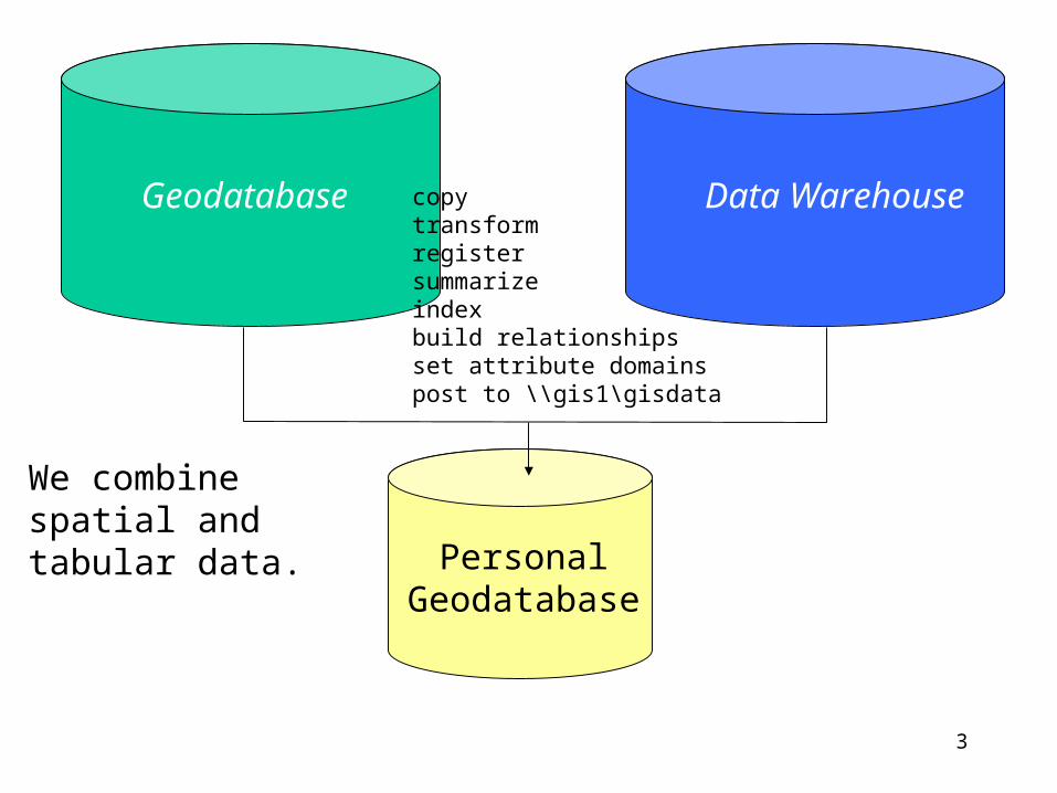
Geodatabase Data Warehouse
PersonalGeodatabase
We combine spatial and tabular data.
copytransformregistersummarizeindexbuild relationshipsset attribute domainspost to \\gis1\gisdata
4
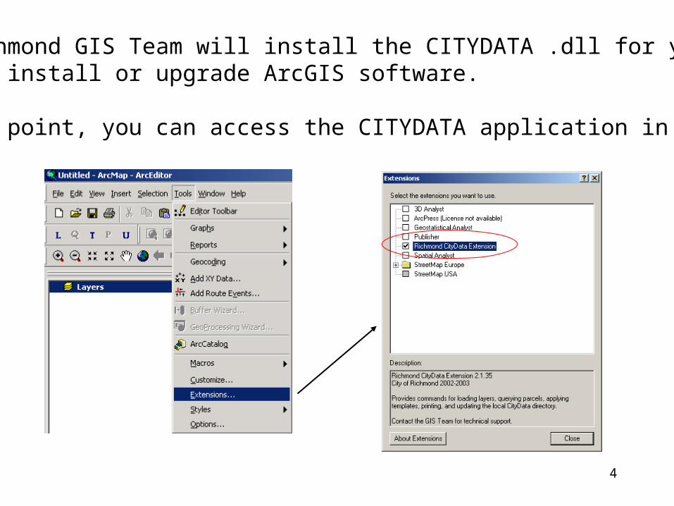
The Richmond GIS Team will install the CITYDATA .dll for you when we install or upgrade ArcGIS software.
At that point, you can access the CITYDATA application in ArcMap!
5
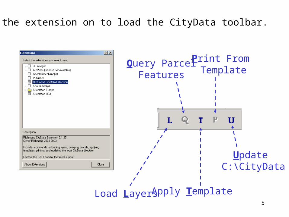
Turn the extension on to load the CityData toolbar.
Load Layers
Query ParcelFeatures
Apply Template
Print From Template
Update C:\CityData
6
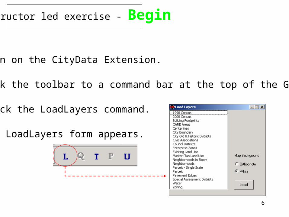
Instructor led exercise - Begin
1) Turn on the CityData Extension.
2) Dock the toolbar to a command bar at the top of the GUI.
3) Click the LoadLayers command.
4) The LoadLayers form appears.
7
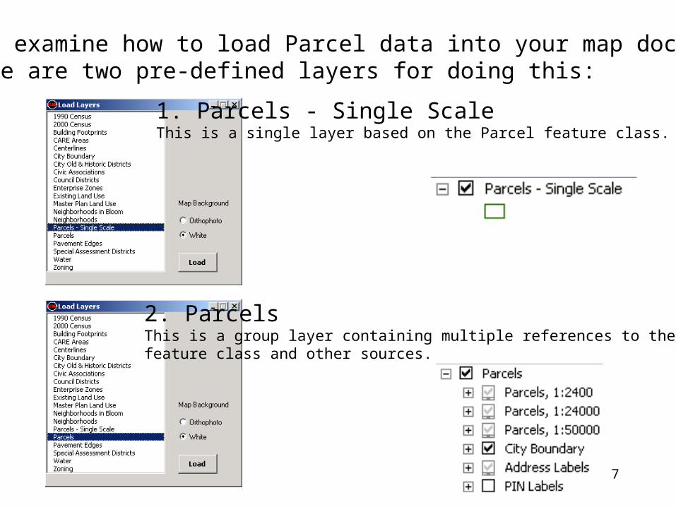
4) Let’s examine how to load Parcel data into your map document. There are two pre-defined layers for doing this:
1. Parcels - Single Scale This is a single layer based on the Parcel feature class.
2. ParcelsThis is a group layer containing multiple references to the Parcel feature class and other sources.
8
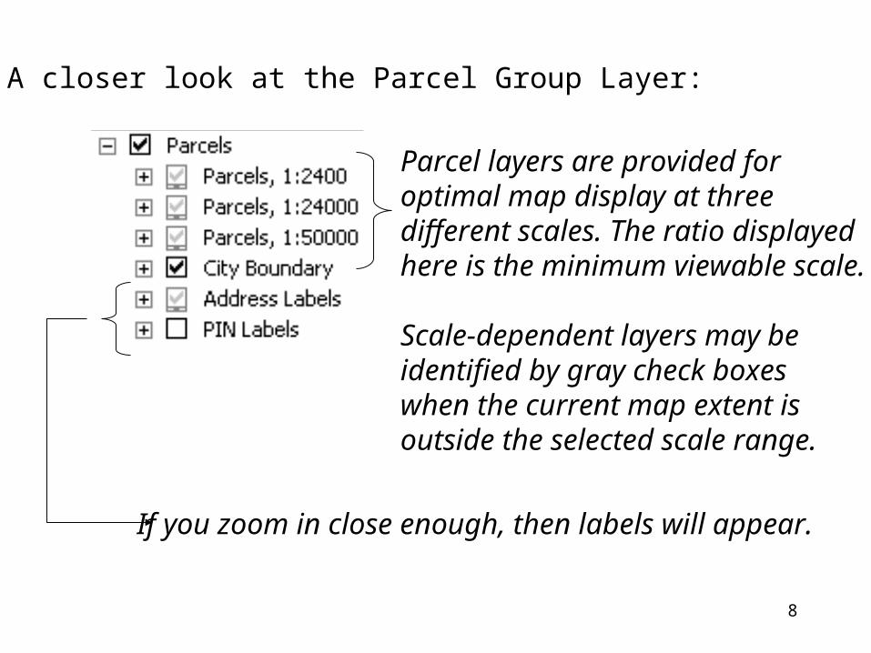
5) A closer look at the Parcel Group Layer:
If you zoom in close enough, then labels will appear.
Parcel layers are provided for optimal map display at three different scales. The ratio displayed here is the minimum viewable scale.
Scale-dependent layers may be identified by gray check boxes when the current map extent is outside the selected scale range.
9
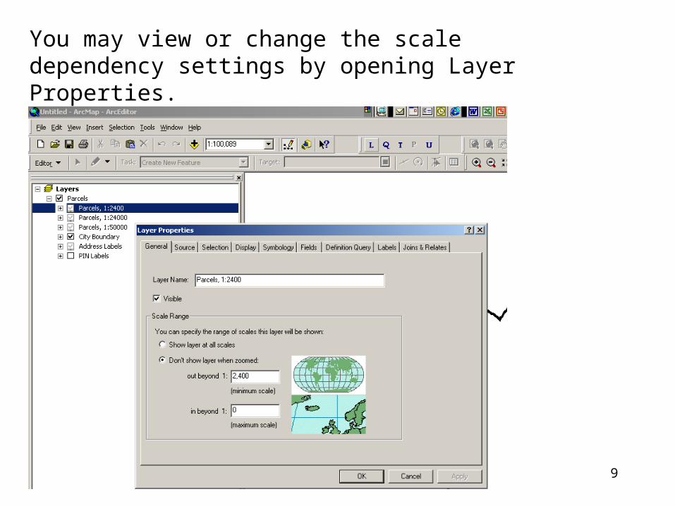
You may view or change the scale dependency settings by opening Layer Properties.
10
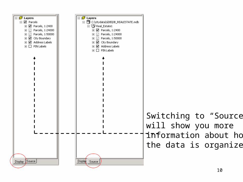
Switching to “Source”will show you moreinformation about howthe data is organized.
11
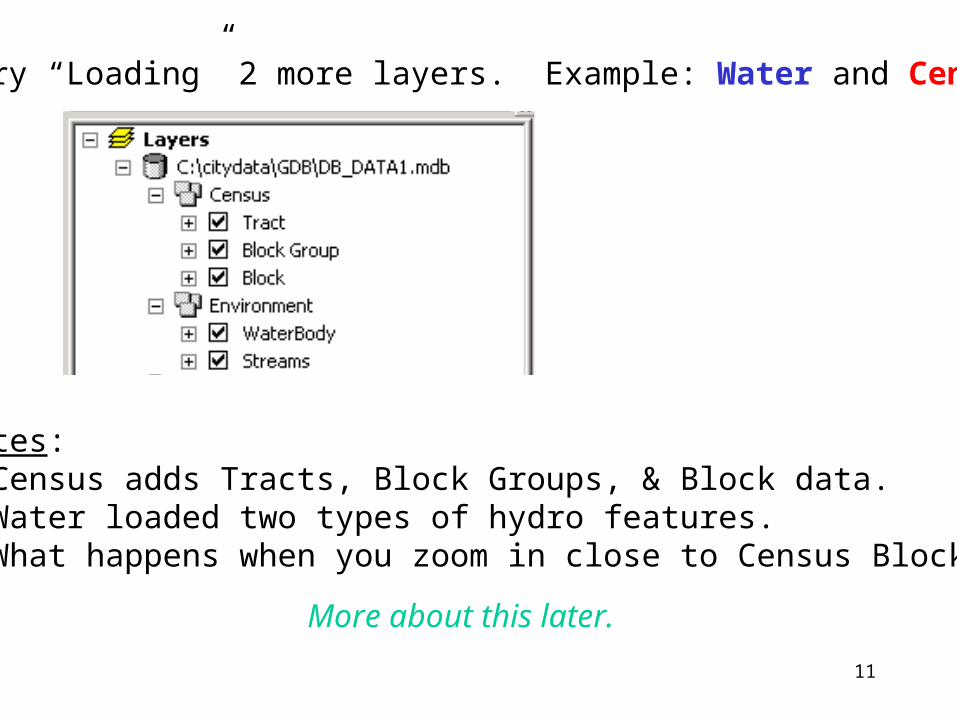
6) Try “Loading” 2 more layers. Example: Water and Census
Notes: • Census adds Tracts, Block Groups, & Block data.• Water loaded two types of hydro features.• What happens when you zoom in close to Census Blocks?
More about this later.
12
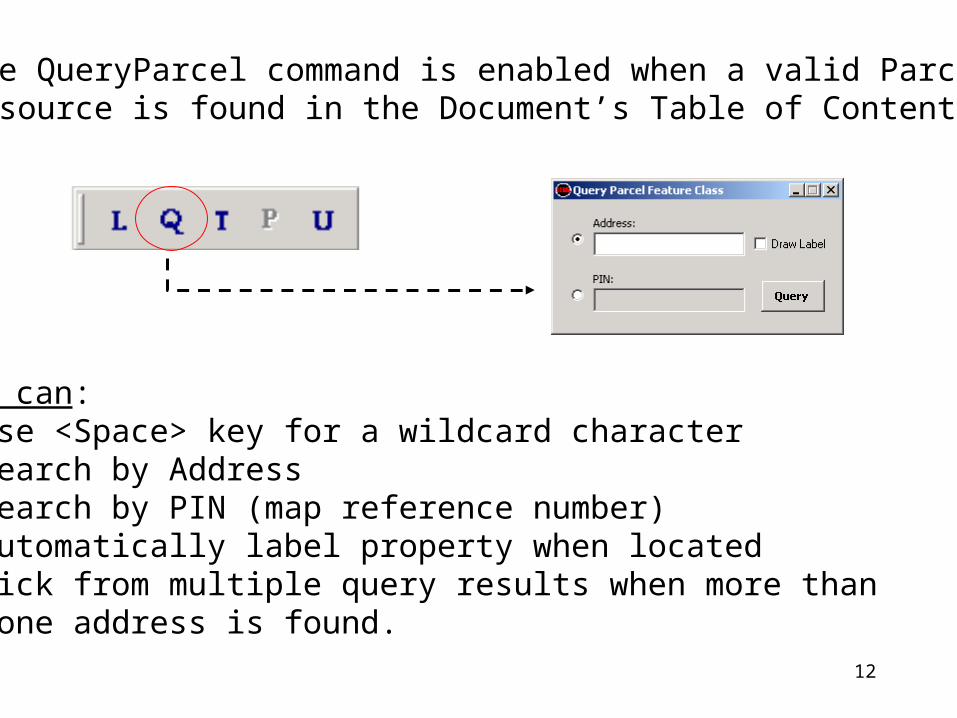
7) The QueryParcel command is enabled when a valid Parcel source is found in the Document’s Table of Contents.
You can:• Use <Space> key for a wildcard character• Search by Address• Search by PIN (map reference number)• Automatically label property when located• Pick from multiple query results when more than one address is found.
13
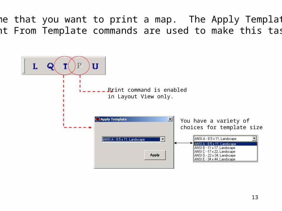
8) Assume that you want to print a map. The Apply Template and Print From Template commands are used to make this task easy.
You have a variety ofchoices for template size
Print command is enabledin Layout View only.
14
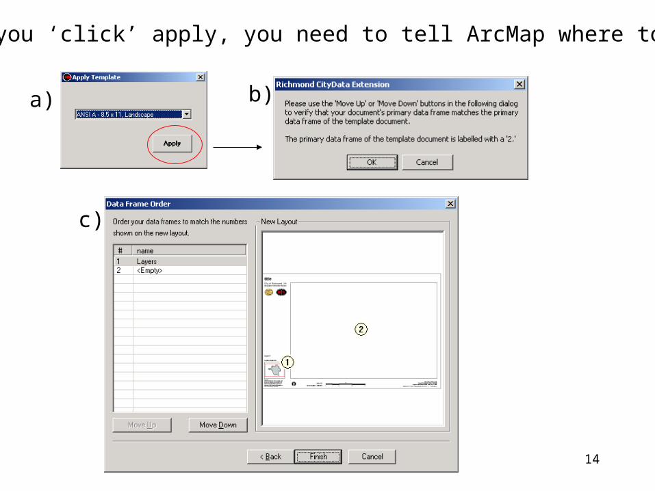
9) After you ‘click’ apply, you need to tell ArcMap where to display
a) b)
c)
15
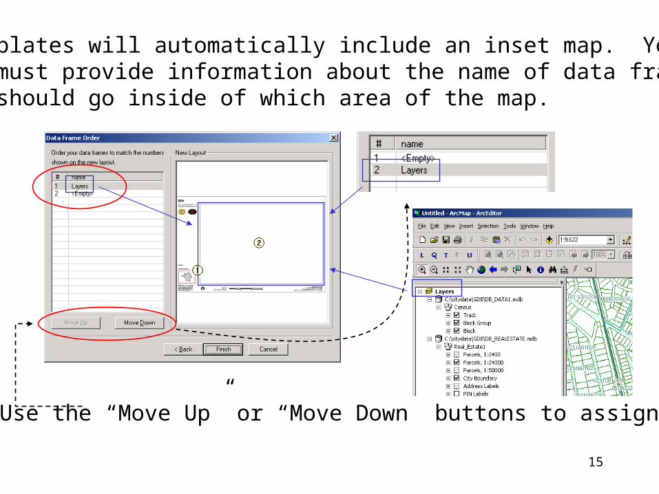
10) Templates will automatically include an inset map. You must provide information about the name of data frame that should go inside of which area of the map.
Use the “Move Up” or “Move Down” buttons to assign.
16
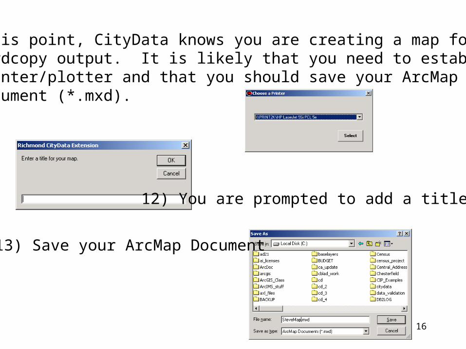
11) At this point, CityData knows you are creating a map for hardcopy output. It is likely that you need to establish a printer/plotter and that you should save your ArcMap Document (*.mxd).
12) You are prompted to add a title
13) Save your ArcMap Document
17
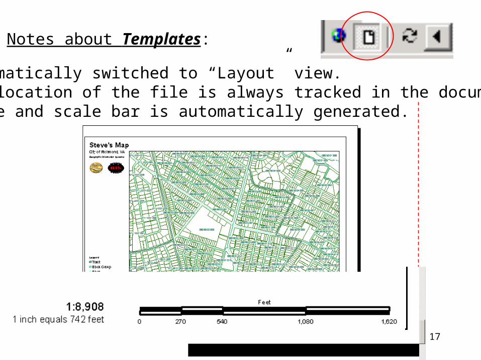
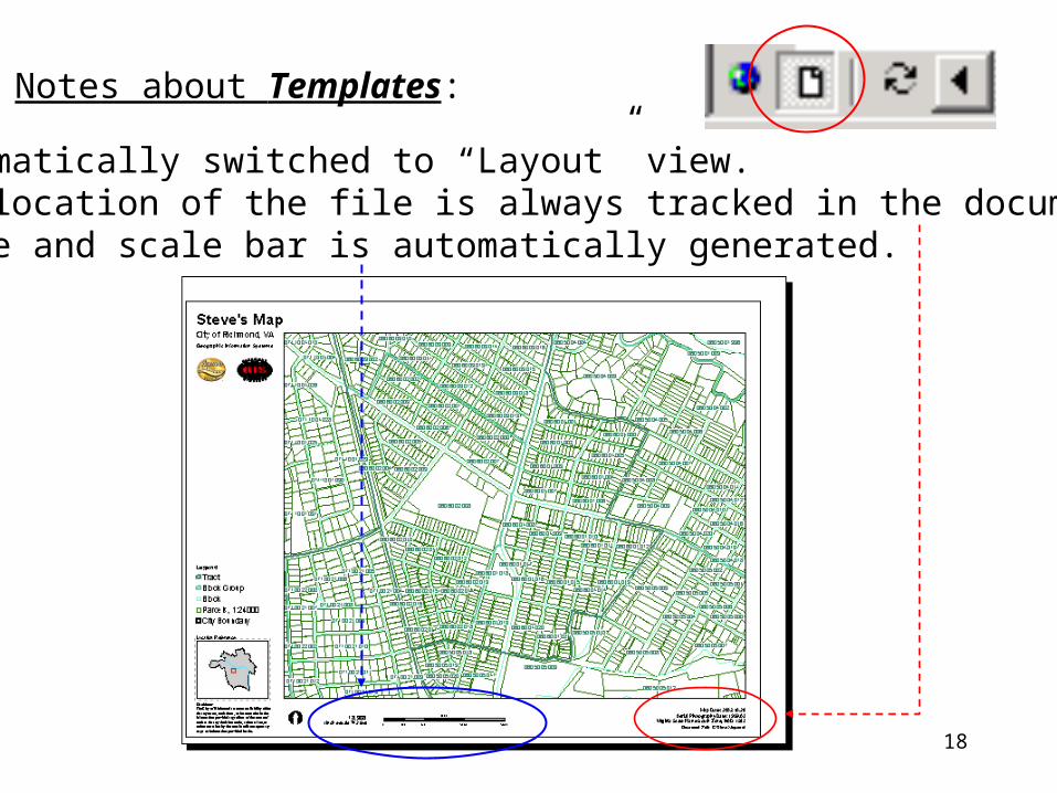
Notes about Templates:
• Automatically switched to “Layout” view.• The location of the file is always tracked in the document!• Scale and scale bar is automatically generated.
18
Notes about Templates:
• Automatically switched to “Layout” view.• The location of the file is always tracked in the document!• Scale and scale bar is automatically generated.
19
Instructor led exercise - End

20
Chapter 6
Exercise
21
Chapter 7
Geodatabase
22
• You need to understand how information is stored in ArcGIS Geodatabase.
• “CityData” is both an ArcGIS extension and application for ArcMap and what is referred to as a “Personal Geodatabase”
• In this chapter, we will also look at what is maintained under your C:\CityData\ directory on your PC.
What’s in store this chapter?
23
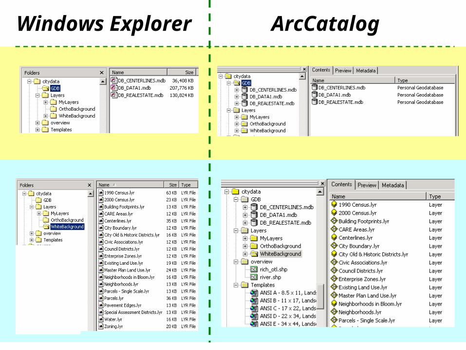
Windows Explorer ArcCatalog
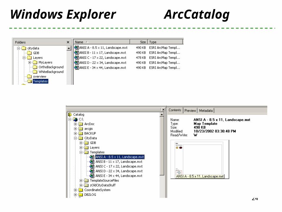
24
Windows Explorer ArcCatalog
25
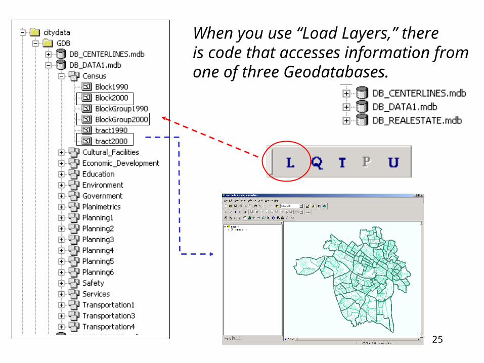
When you use “Load Layers,” thereis code that accesses information fromone of three Geodatabases.
26
What is a Geodatabase
A Geodatabase is a store of geographic data implemented withThe relational database of your choice.
• The City maintains a central Geodatabase in SQLServer, which is used to edit, maintain and process data.
• If you are not a custodian who is editing a geographic layer, then you are using the Personal Geodatabase, which is delivered as a Microsoft Access database.
27
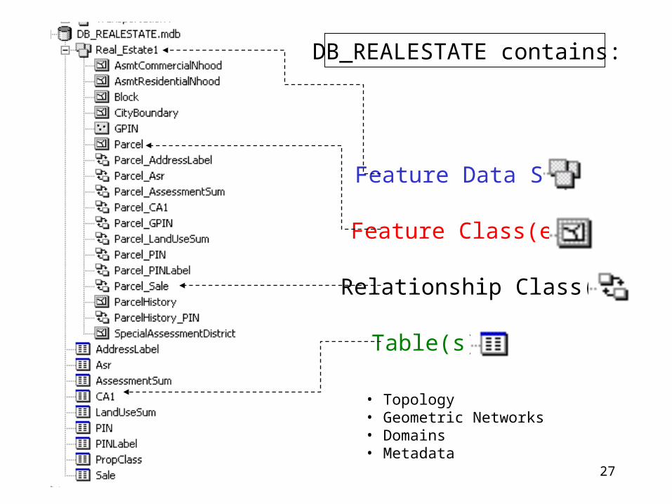
DB_REALESTATE contains:
Feature Data Set
Feature Class(es)
Table(s)
Relationship Class(es)
• Topology• Geometric Networks• Domains• Metadata
28
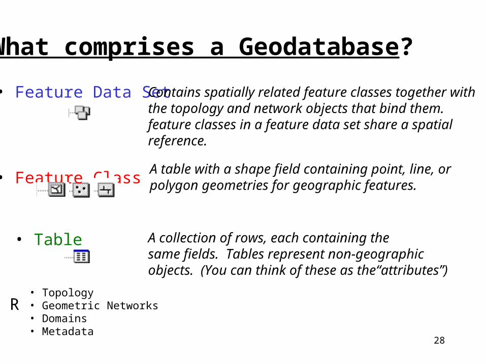
What comprises a Geodatabase?
• Feature Data Set
• Feature Class
Contains spatially related feature classes together withthe topology and network objects that bind them.feature classes in a feature data set share a spatial reference.
A table with a shape field containing point, line, or polygon geometries for geographic features.
• Table A collection of rows, each containing the same fields. Tables represent non-geographicobjects. (You can think of these as the“attributes”)
• Relationship Classes• Topology• Geometric Networks• Domains• Metadata
29
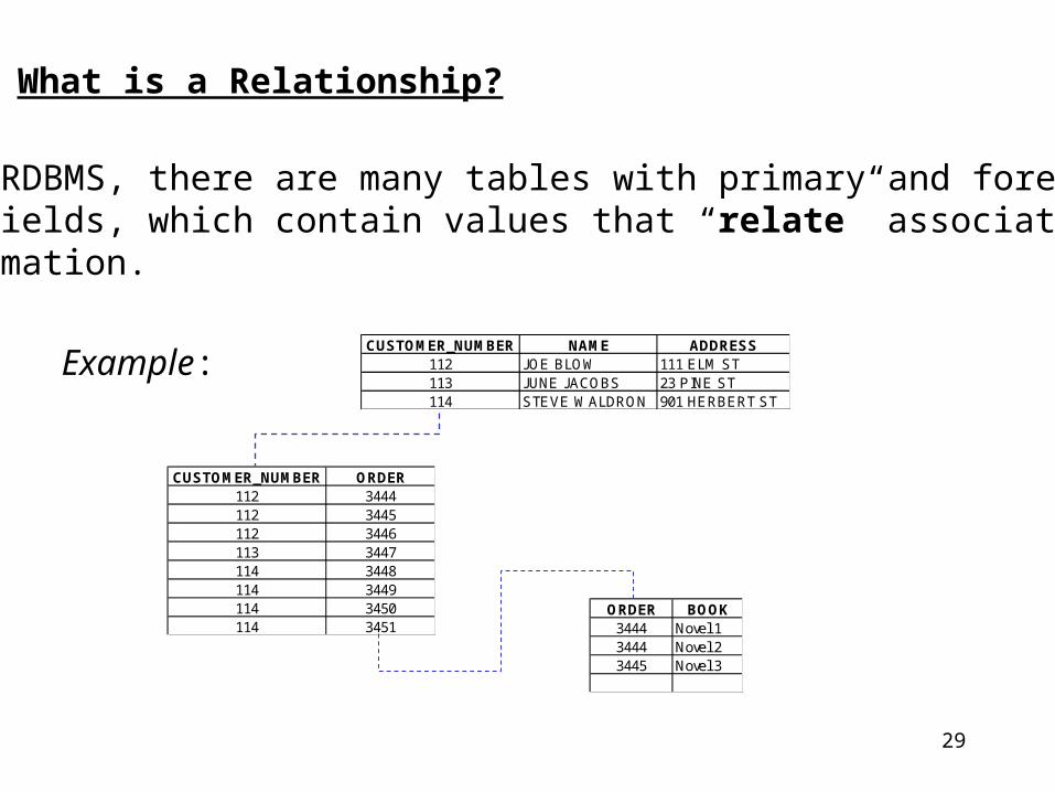
What is a Relationship?
In a RDBMS, there are many tables with primary and foreign key fields, which contain values that “relate” associated information.
Example:CUSTOMER_NUMBER NAME ADDRESS
112 JOE BLOW 111 ELM ST113 JUNE JACOBS 23 PINE ST114 STEVE WALDRON 901 HERBERT ST
CUSTOMER_NUMBER ORDER112 3444112 3445112 3446113 3447114 3448114 3449114 3450114 3451
ORDER BOOK3444 Novel 13444 Novel 23445 Novel 3
30
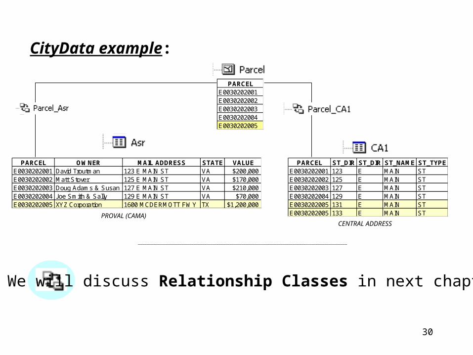
CityData example:
PARCELE0030202001E0030202002E0030202003E0030202004E0030202005
PARCEL ST_DIR ST_DIR ST_NAME ST_TYPEE0030202001 123 E MAIN STE0030202002 125 E MAIN STE0030202003 127 E MAIN STE0030202004 129 E MAIN STE0030202005 131 E MAIN STE0030202005 133 E MAIN ST
PARCEL OWNER MAIL ADDRESS STATE VALUEE0030202001 David Troutman 123 E MAIN ST VA $200,000E0030202002 Matt Stover 125 E MAIN ST VA $170,000E0030202003 Doug Adams & Susan 127 E MAIN ST VA $210,000E0030202004 Joe Smith & Sally 129 E MAIN ST VA $70,000E0030202005 XYZ Corporation 1600 MCDERMOTT FWY TX $1,200,000
CENTRAL ADDRESSPROVAL (CAMA)
We will discuss Relationship Classes in next chapter
31
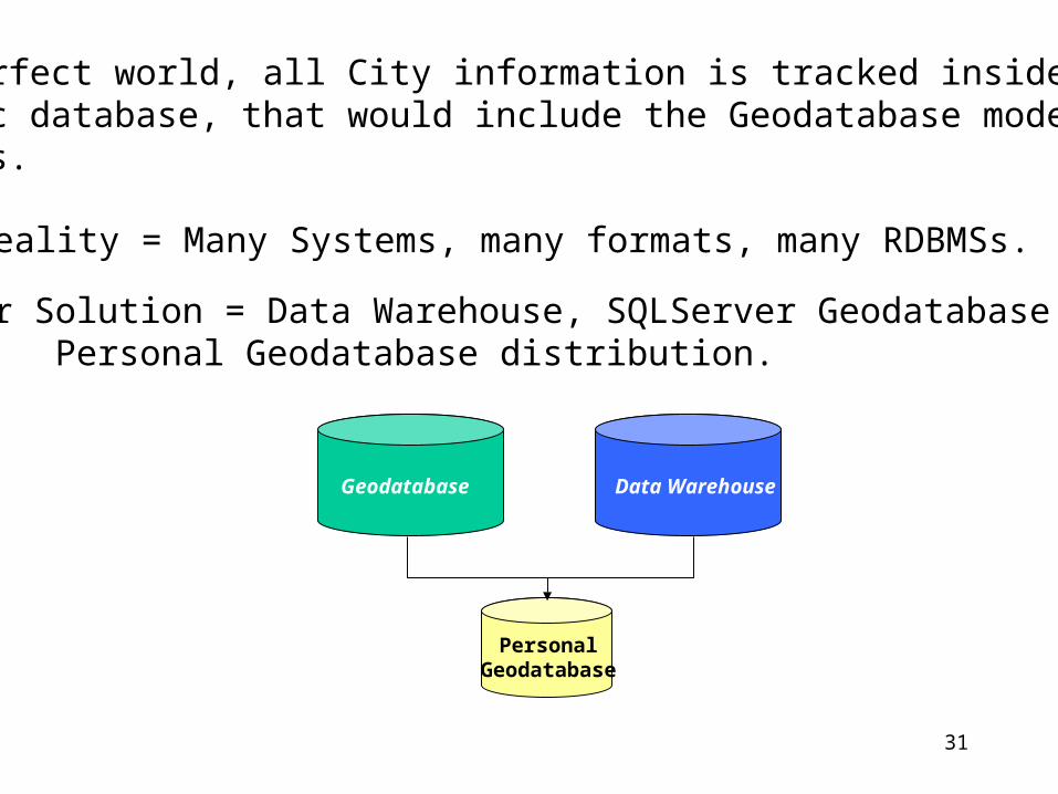
Geodatabase Data Warehouse
PersonalGeodatabase
In a perfect world, all City information is tracked inside one holistic database, that would include the Geodatabase modeledfeatures.
• Reality = Many Systems, many formats, many RDBMSs.
• Our Solution = Data Warehouse, SQLServer Geodatabase; Personal Geodatabase distribution.
32
Instructor led exercise - Begin
Browsing Geodatabases.
Instructor led exercise - End

33
Chapter 8
Joins & Relates
34
Tables can be added to ArcMap just like geographic data.
• Tables contain attributes• We attempt to deliver most things you’ll need from the data warehouse with “CityData,” but we can’t predict all your needs• You may have your own data that you want to load into ArcMap in order to map and analyze.
First, you will observe an Instructor-led demo.
Second, you will perform a scripted class exercise.
35
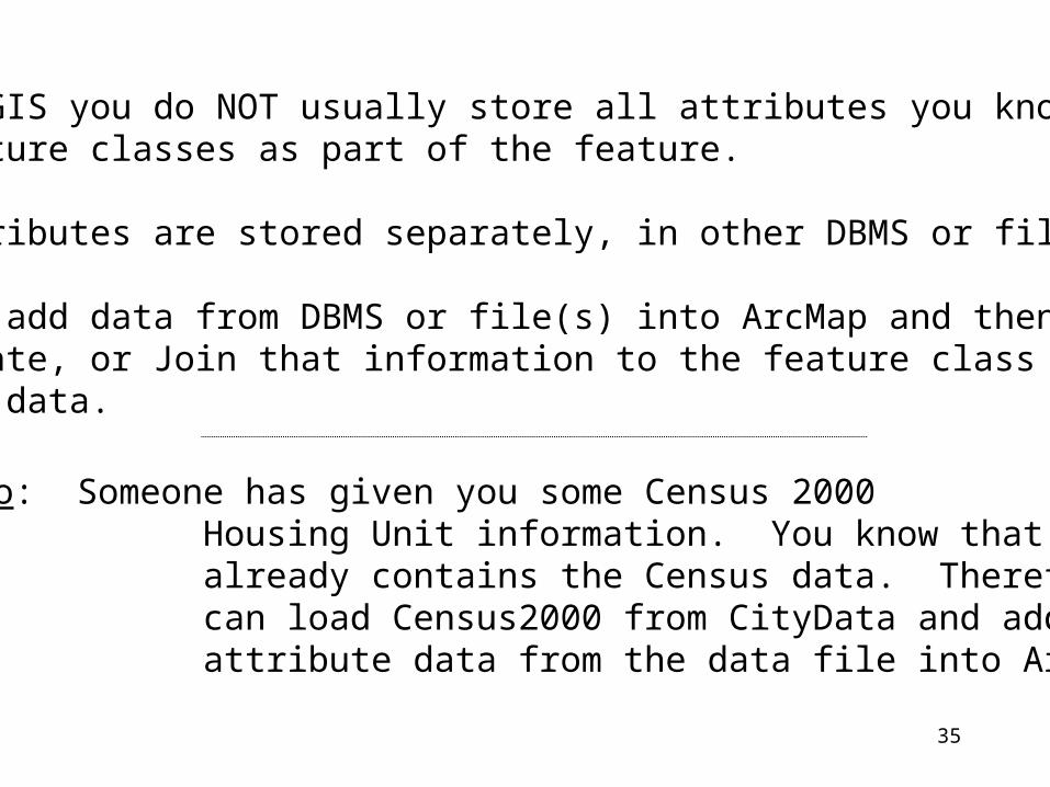
• In GIS you do NOT usually store all attributes you know about feature classes as part of the feature.
• Attributes are stored separately, in other DBMS or file(s).
• You add data from DBMS or file(s) into ArcMap and then Relate, or Join that information to the feature class to use the data.
Scenario: Someone has given you some Census 2000 Housing Unit information. You know that CityData already contains the Census data. Therefore, you can load Census2000 from CityData and add the attribute data from the data file into ArcMap.
36
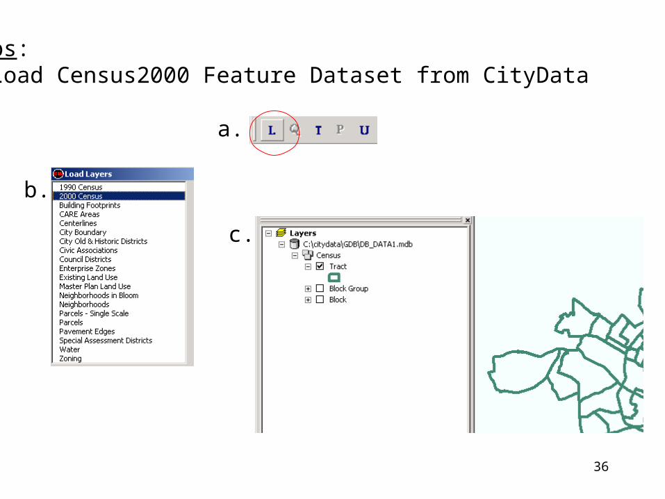
Steps: 1) Load Census2000 Feature Dataset from CityData
a.
b.
c.

37
2) Add data table into ArcMap
38
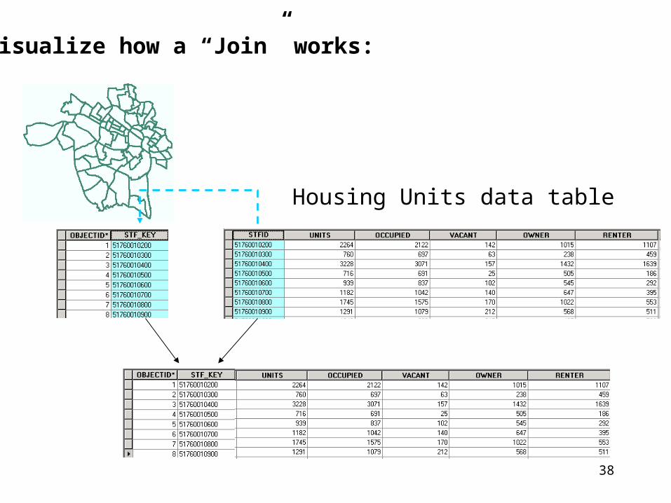
Visualize how a “Join” works:
Housing Units data table
39
How to “Join”
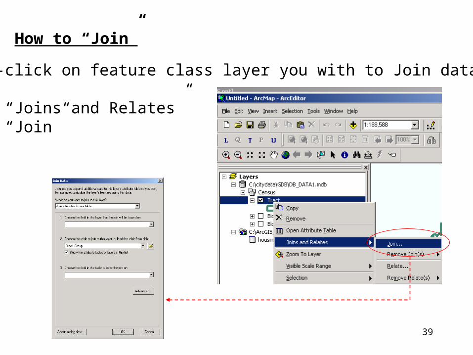
3) Right-click on feature class layer you with to Join data “to”:
• Select “Joins and Relates”• Select “Join”
40
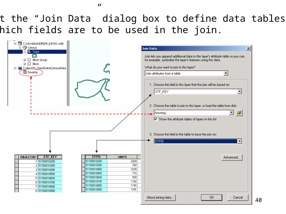
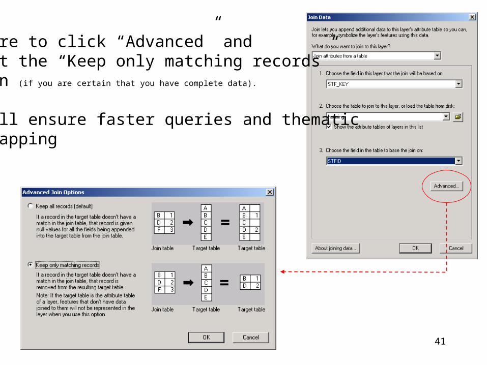
4) Fill out the “Join Data” dialog box to define data tables to be used and which fields are to be used in the join.
41
Be sure to click “Advanced” and select the “Keep only matching records”Option (if you are certain that you have complete data).
• Will ensure faster queries and thematic mapping
42
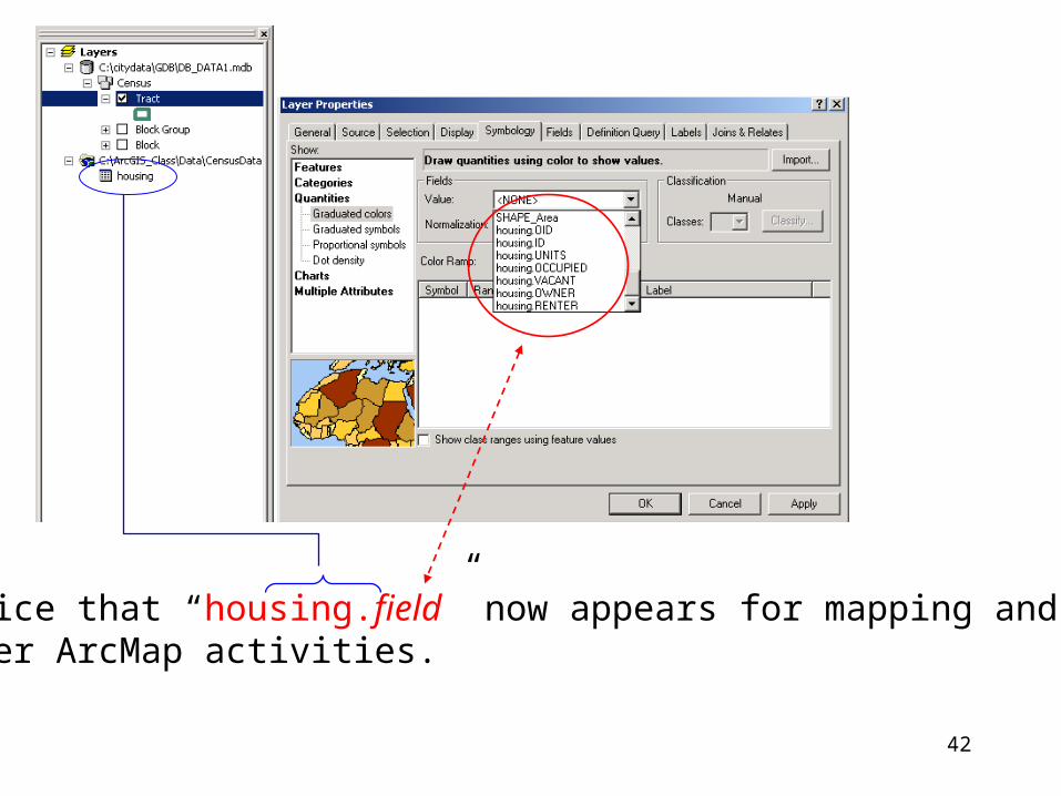
Notice that “housing.field” now appears for mapping andother ArcMap activities.

43
Chapter 8
Exercise

44
Chapter 9
Joins & CityData
45
70
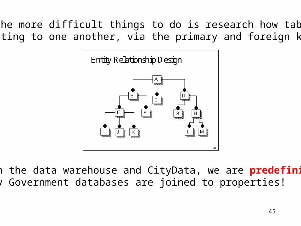
Entity Relationship Design
One of the more difficult things to do is research how tablesare relating to one another, via the primary and foreign keys.
With the data warehouse and CityData, we are predefining howCity Government databases are joined to properties!
46
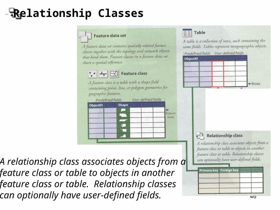
Relationship Classes
A relationship class associates objects from afeature class or table to objects in anotherfeature class or table. Relationship classescan optionally have user-defined fields.
47
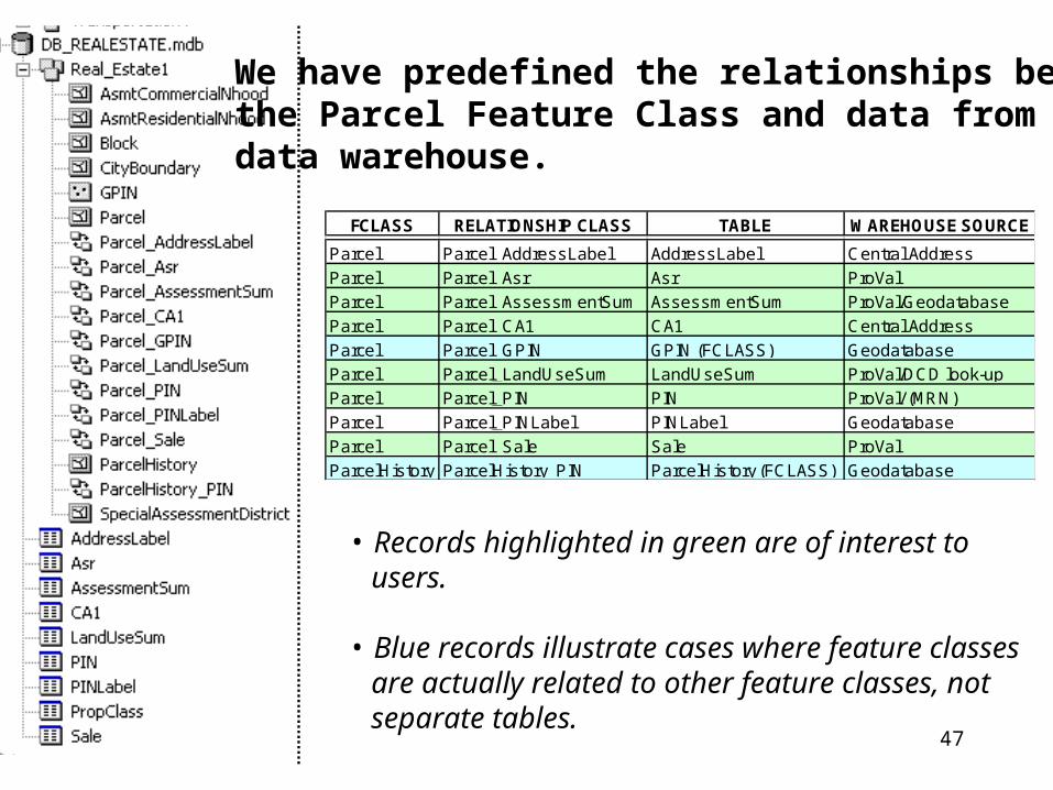
We have predefined the relationships betweenthe Parcel Feature Class and data from the data warehouse.
• Records highlighted in green are of interest to users.
• Blue records illustrate cases where feature classes are actually related to other feature classes, not separate tables.
FCLASS RELATIONSHIP CLASS TABLE WAREHOUSE SOURCE
Parcel Parcel_AddressLabel AddressLabel Central Address
Parcel Parcel_Asr Asr ProVal
Parcel Parcel_AssessmentSum AssessmentSum ProVal/Geodatabase
Parcel Parcel_CA1 CA1 Central Address
Parcel Parcel_GPIN GPIN (FCLASS) Geodatabase
Parcel Parcel_LandUseSum LandUseSum ProVal/DCD look-up
Parcel Parcel_PIN PIN ProVal/ (MRN)
Parcel Parcel_PINLabel PINLabel Geodatabase
Parcel Parcel_Sale Sale ProVal
ParcelHistory ParcelHistory_PIN ParcelHistory (FCLASS) Geodatabase
48
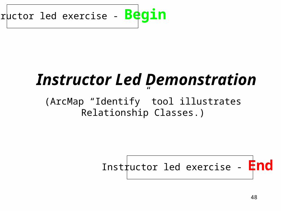
Instructor led exercise - Begin
Instructor Led Demonstration
Instructor led exercise - End
(ArcMap “Identify” tool illustratesRelationship Classes.)
49
So how do I perform joining of data tables to feature classes in CityData?
When joining data to parcels, we have already predefined how data is supposed to relate.
You simply choose the Relationship Class that you want to use.
• As of the Fall, 2002, CityData only contains data from Assessor’s data marts and Central Address for Joins.
Note:
50
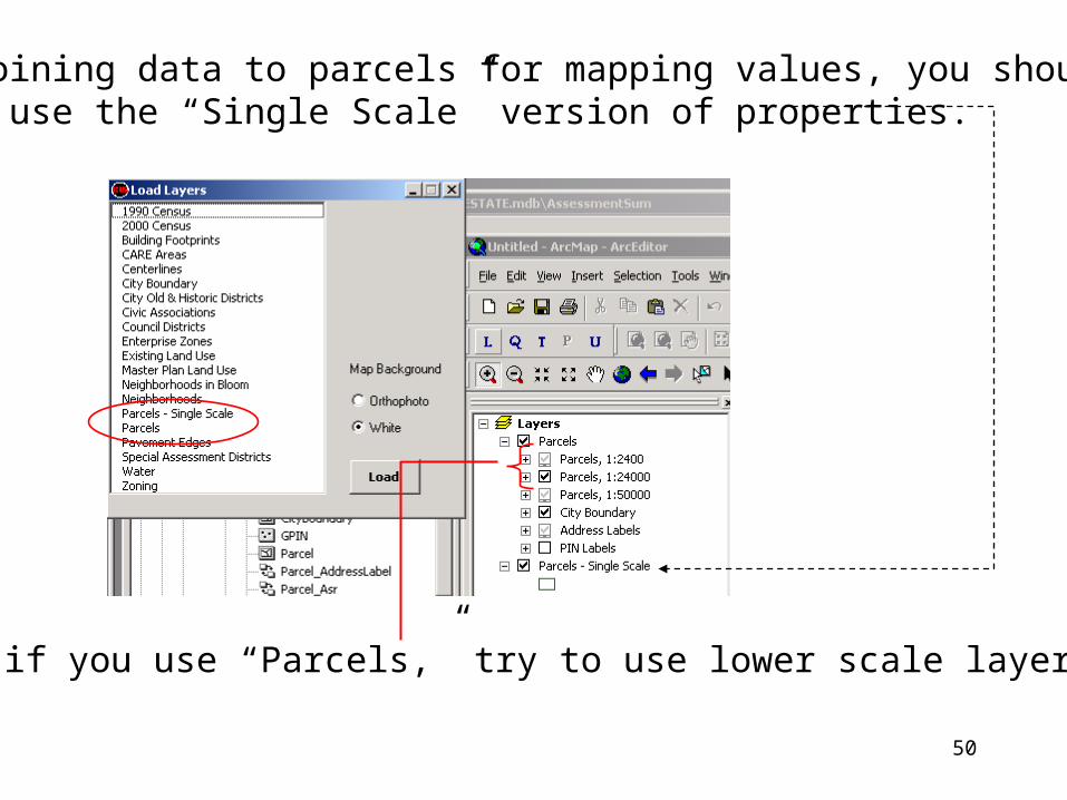
When joining data to parcels for mapping values, you should try to use the “Single Scale” version of properties.
(Or, if you use “Parcels,” try to use lower scale layers)
51
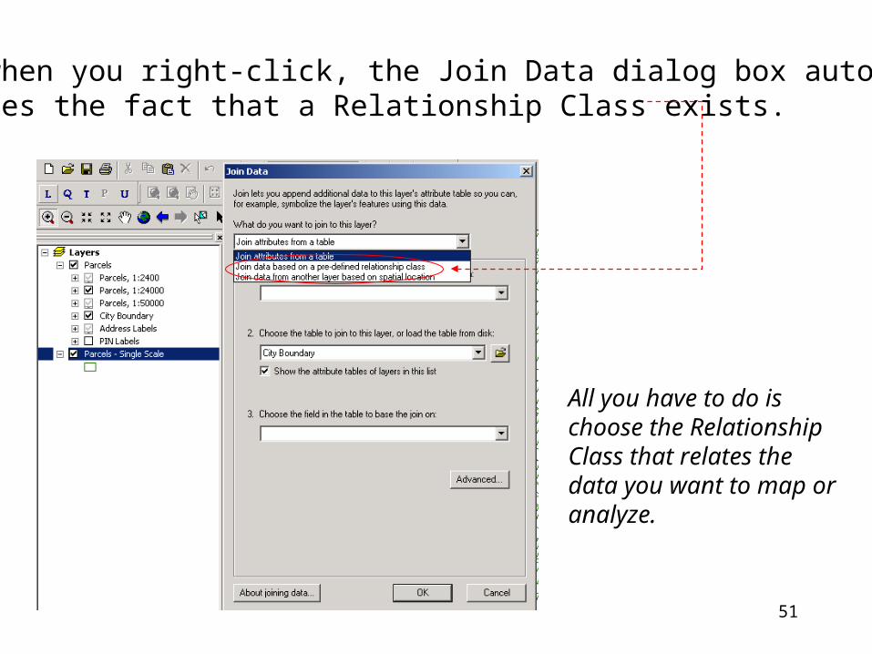
Notice when you right-click, the Join Data dialog box automaticallyrecognizes the fact that a Relationship Class exists.
All you have to do ischoose the RelationshipClass that relates the data you want to map oranalyze.
52
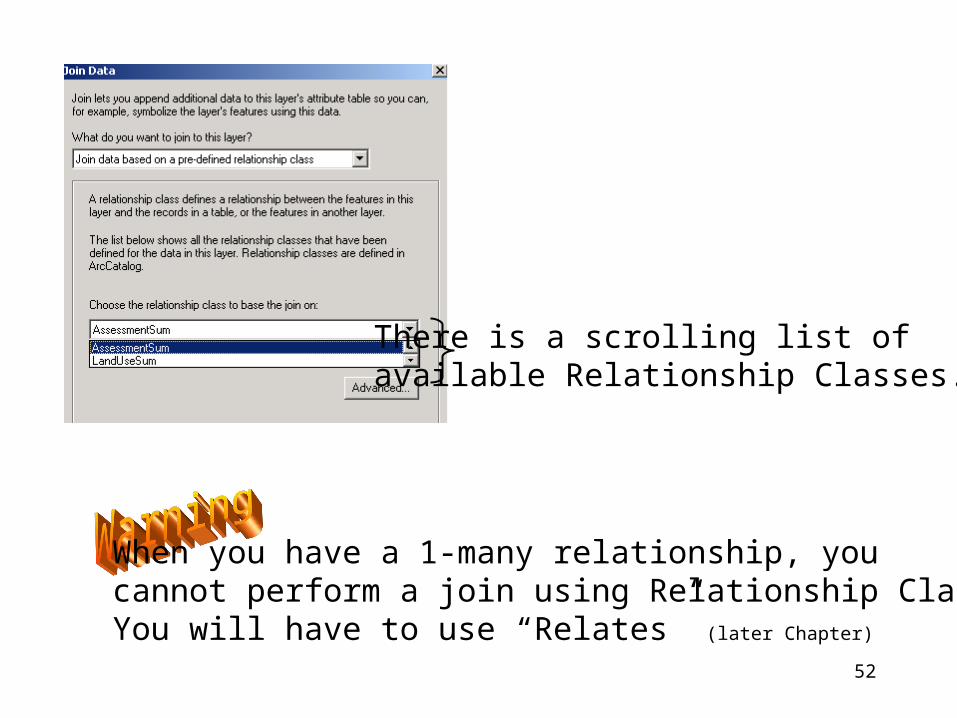
There is a scrolling list of available Relationship Classes.
When you have a 1-many relationship, you cannot perform a join using Relationship Classes.You will have to use “Relates” (later Chapter)
53
You must know the business logic or details of the informationyou are trying to use!
54
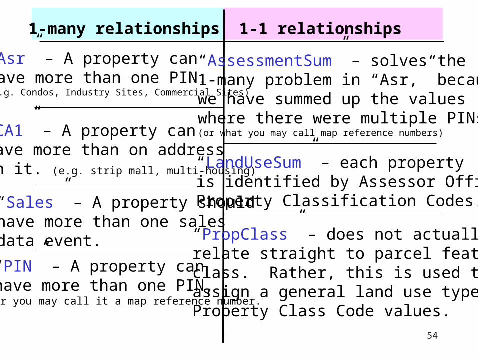
1-many relationships 1-1 relationships
“Asr” – A property canhave more than one PIN.(e.g. Condos, Industry Sites, Commercial Sites)
“AssessmentSum” – solves the1-many problem in “Asr,” becausewe have summed up the valueswhere there were multiple PINs(or what you may call map reference numbers)“CA1” – A property can
have more than on addresson it. (e.g. strip mall, multi-housing)
“LandUseSum” – each propertyis identified by Assessor OfficeProperty Classification Codes.
“PropClass” – does not actuallyrelate straight to parcel featureclass. Rather, this is used to assign a general land use type toProperty Class Code values.
“Sales” – A property shouldhave more than one salesdata event.
“PIN” – A property can have more than one PIN,or you may call it a map reference number.
55
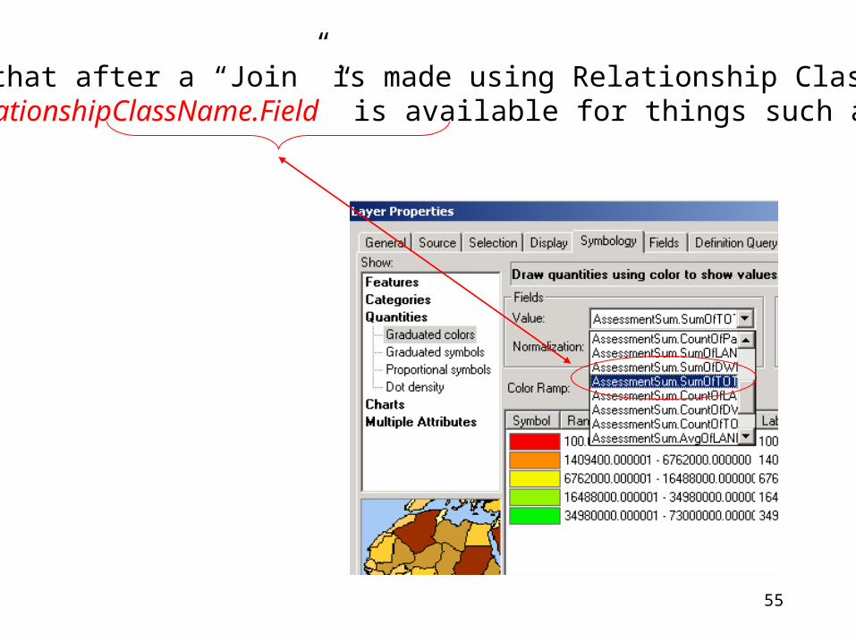
Notice that after a “Join” is made using Relationship Class, thatthe “RelationshipClassName.Field” is available for things such asmapping.

56
Chapter 9
Exercise
57
Chapter 11
Relates(Dealing with 1-Many Relationships)
58
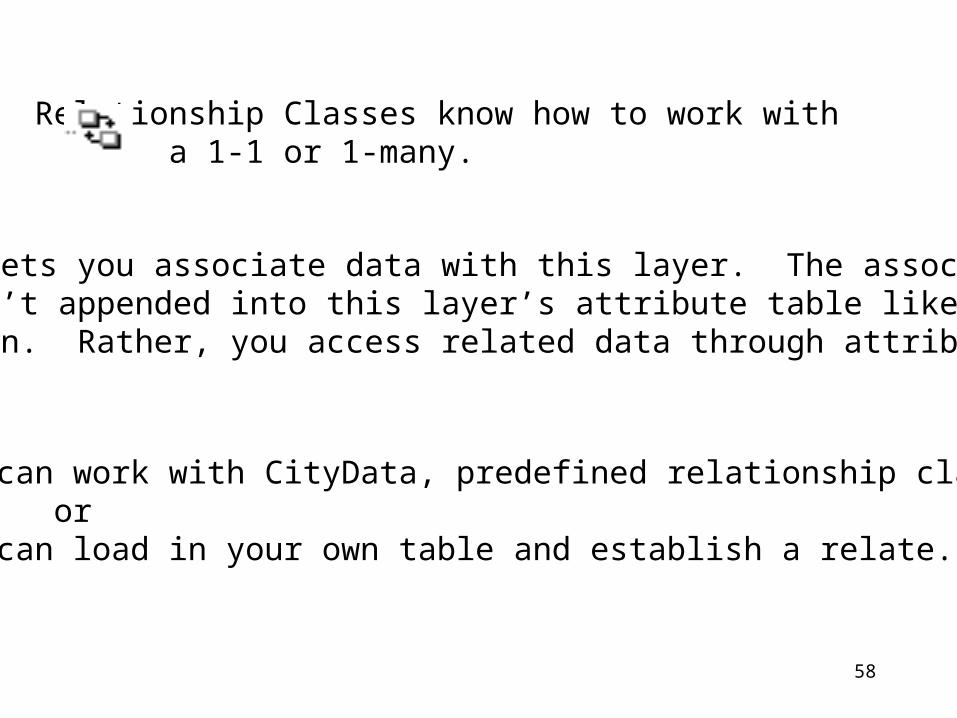
Relationship Classes know how to work with a 1-1 or 1-many.
Relate lets you associate data with this layer. The associateddata isn’t appended into this layer’s attribute table like it is in a Join. Rather, you access related data through attributetables.
• You can work with CityData, predefined relationship classes. or• You can load in your own table and establish a relate.
59
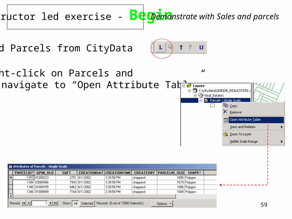
Instructor led exercise - Begin
1) Load Parcels from CityData
2) Right-click on Parcels and navigate to “Open Attribute Table”
Demonstrate with Sales and parcels
60
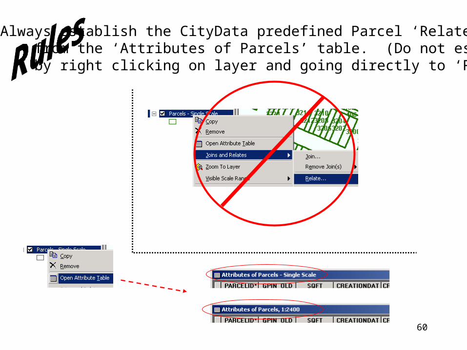
Always establish the CityData predefined Parcel ‘Relates’ from the ‘Attributes of Parcels’ table. (Do not establish by right clicking on layer and going directly to ‘Relates’)
61
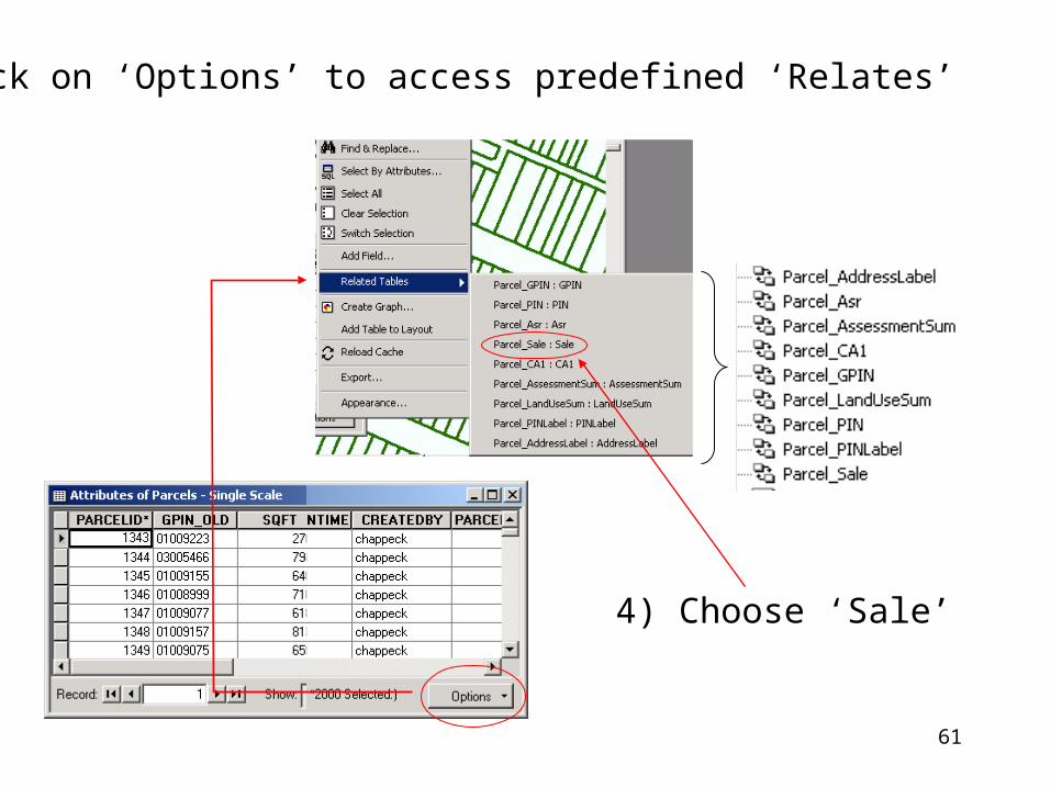
3) Click on ‘Options’ to access predefined ‘Relates’
4) Choose ‘Sale’
62
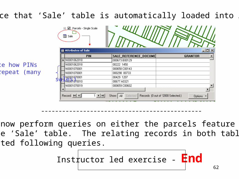
5) Notice that ‘Sale’ table is automatically loaded into ArcMap
Notice how PINscan repeat (many sales)
You can now perform queries on either the parcels feature classor on the ‘Sale’ table. The relating records in both tables can behighlighted following queries.
Instructor led exercise - End
63
Instructor will continue to illustrate how ‘Relates’ can be used for analysis/querying.
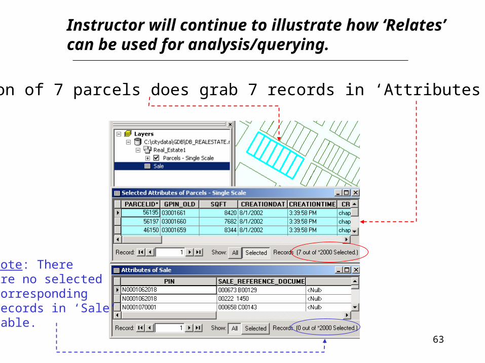
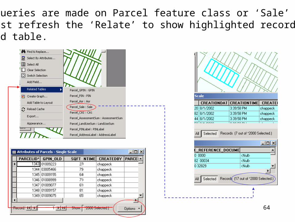
6) Selection of 7 parcels does grab 7 records in ‘Attributes of Parcels’
Note: ThereAre no selectedCorrespondingRecords in ‘Sale’Table.
64
7) After queries are made on Parcel feature class or ‘Sale’ table, you must refresh the ‘Relate’ to show highlighted records in related table.
65
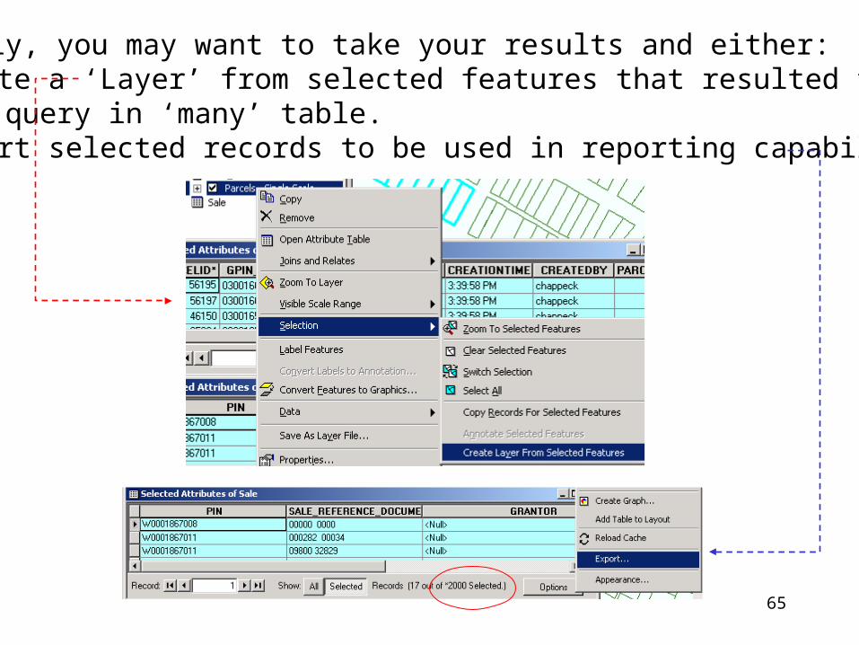
8) Finally, you may want to take your results and either:• Create a ‘Layer’ from selected features that resulted from
query in ‘many’ table.• Export selected records to be used in reporting capabilities.