Embed Size (px)
Citation preview

Asian Development Bank TA 4669-CAM
Technical Assistance to the Kingdom of Cambodia for the Study of the Influence of Built Structures
on the Fisheries of the Tonle Sap (financed by the Government of Finland)
Database Component
DATABASE DOCUMENTATION
Prepared by:
Hannu LAURI
EIA Ltd, Finland
April 2007

2
CONTENTS Purpose of the database component .......................................................................... 3 Classification of built structures................................................................................... 3
Structure type classification .................................................................................... 3 Structure attributes.................................................................................................. 5
Selection criteria for structures.................................................................................... 6 Spatial extent .......................................................................................................... 6 Flow impact classification........................................................................................ 6
Database..................................................................................................................... 6 Database tables ...................................................................................................... 7 Class dependent data ........................................................................................... 10 Area data............................................................................................................... 30
System components and setup................................................................................. 30 Appendix A: Glossary................................................................................................ 34 Appendix B: Tonle Sap catchment statistics ............................................................. 35 Appendix C: Data directory ....................................................................................... 37

3
PURPOSE OF THE DATABASE COMPONENT OF THE PROJECT The main task of the database component of the Built Structures project is to prepare a database of existing surface water and surface water quality related structural works in the Tonle Sap Basin. The database should contain the geographic extent and characteristics of these structures. The database will be used in the assessment of the consequences of built structures on the environmental and human components of the lake ecosystem. A built structure is defined here as a structure that
(i) opposes water outflow (e.g. dams, weirs, irrigation schemes, levees, embankments);
(ii) prevents water inflow (e.g. . roads, railways, flood control works, polders, dykes, wharves and quays);
(iii) alters water inflow or outflow (e.g. drainage canals, diversion structures, agricultural works, and flow modifications);
(iv) may degrade water quality (e.g. plants with aqueous effluents, mining and mineral processing facilities, petroleum storage facilities, sewerage systems, and dredges); and
(v) Fishing gears that can alter hydrological flows and obstruct fish movement.
The main emphasis of the database is on structures of type (i), (ii) and (v).
CLASSIFICATION OF BUILT STRUCTURES The structures are grouped in the database using structure type classification, derived from structure type and usage. The type classification
1. Assigns exactly one type class for each existing structure in the target area, 2. Determines what characteristics of a given structure are stored in the
database, 3. Aids database users in searching for structures that have specific impacts, 4. Is easy to understand for the database user.
STRUCTURE TYPE CLASSIFICATION
1 Storage 110 Reservoir 120 Floodwater storage
2 Flow route 210 Canal 211 Irrigation canal 210 Bridge 230 Culvert 240 Spillway

4
3 Flow control 310 Dam 320 Embankment 321 Road embankment primary road 322 Road embankment other 323 Railroad embankment 324 Reservoir dike 330 Gate 340 Weir 350 Pumping station 360 Hydropower station 370 Measurement station 371 Hydrological station 372 Meteorological station
4 Fish and aquaculture 410 Fishing gear 411 Dai fishery 412 River barrage with bagnet or trap 413 Fence system fence 414 Fence system trap 415 Fence system pen 420 Fishway 430 Aquaculture 431 Fish pond 432 Fish cage 440 Fishing lot 450 Fish sanctuary
5 Erosion prevention 510 Reinforced bank 520 RipRap
6 Agriculture 610 Rice field 620 Field crops 630 Plantation 640 Other agriculture 650 Irrigated area
7 Transportation 710 Docks/Harbour 720 Breakwater 730 Ferry
8 Discharge 810 Point source 811 Sewage treatment plant 812 Sewage outlet 813 Industrial sewage outlet 814 Mine 820 Diffuse source 821 Scattered population

5
STRUCTURE ATTRIBUTES Structure attributes are values that describe a given structure and are stored in the database. The following data is stored:
− Structure name − Structure position (mid-point position), UTM (Universal Transverse Mercator,
zone 48N with false easting of 500000, and WGS84 datum) − Structure outline, mid-line or point location, coordinate system as above − Structure creation (and demolition) date − Database diary data; entry date and user ID − Main physical dimensions of the structure − Main hydrological characteristics of the structure − Photographs of the structure
Below is a table of attributes based on the above structure classification. Attributes for all classes
Field Type Unit Explanation id Int - Structure identifier class_id Int - Structure class identifier name String - Name of structure info String - Additional information in text format xpos Real m x-coordinate of mid-point (UTM) ypos Real m y-coordinate of mid-point (UTM) boundary Geom - Boundary/mid-line/mid-point data constructed Date - Construction date (when taken to use) demolished Date - Demolition date (when taken out of use) entrydate Date - Date when entered into database entryby String - Userid of user who created this entry datasource String - Datasource acronym srid Int - Coordinate system identifier boundary Geom - Mid-point/boundary/mid-line geometry data
Class-dependent attributes
Field Type Unit Explanation width Real m Width of structure height Real m Height of structure length Real m Length of structure area Real m2 Area or structure (at the maximum water level) activestorage Real m3 Storage volume between minimum and
maximum water levels minlevel Real m Water level at which flow out or through a
structure stops maxdepth Real m Maximum water level for a structure crestlevel Real m Minimum water level for flow to occur over
structure maxflow Real m3/s Maximum flow on maximum water level crsection Real m2 Channel/opening cross section area at
maximum water level wldrop Real m Water level drop over structure material String - Construction material, e.g.
timber/earth/stones/concrete/metal

6
production Real kg/a Approximate production per year
SELECTION CRITERIA FOR STRUCTURES
SPATIAL EXTENT The database contains structures in the Tonle Sap Basin as defined by the watershed boundary. Spatial emphasis is on the areas through which water flows to the Tonle Sap, and more generally on areas that are or have been under water during the flood season. The Tonle Sap flooded area is shown in Figure 1 and is mostly limited by National Roads nº 5 and 6. The project target sites in Preak Toal, Pursat and Chinit are included in the database with some more detail.
Figure 1: Geographic boundary for database contents
FLOW IMPACT CLASSIFICATION Structures in the area are divided roughly into three categories according the impact of the structure on water flow. The classes are large, mid-size and small structure. Large structures may have catchment scale impacts, mid-size structures have regional scale impacts, and small-scale structures have only local impacts. A limit for large structures is here defined as a structure that can store at least 2.5 million m3 water (in a year), or modify existing flows for at least 1 m3/s on average, or 4 m3/s during peak flow time. A limit for mid-size structures is defined as a structure that can store at least 0.5 million m3 water (in a year), or modify existing flows for at least 0.5 m3/s on average, or 2 m3/s during peak flow time. Structures that store water modify flows less than mid-size structures that belong to the small category. The database mainly contains large and mid-size structures. Structures classified as small may also be included in the database in some cases, for example, if the impact of a structure is not known or the attributes required for assessing the structure size are not available.

7
DATABASE The data is put into a relational database with the capability to store geometry types MySQL database version 5.0.21 is used here. The MySQL database is free, and contains user friendly tools for installation, database management, and queries. Also, tools for data import from shapefile to the database are available. A map-based data viewer Java applet was constructed to allow remote access to the database data using an Internet browser. Export of data to and from the database to GIS programs can be done by writing selected database contents to an ESRI shapefile. The shapefile attribute table will contain selected structure properties.
DATABASE TABLES The database contains the following tables:
− Structure table – table for storing structure attributes − Class table – table for storing structure classification data − Photo table – table for storing photographs of structures − Contact table – table for storing contact information for structure managers,
database users and data sources − Validation table – table for storing validation data − Discharge table – table for storing point load data − Area table – geographic data that can be used to geographically select
structure data, for example, catchment boundaries, main rivers, districts and province boundaries, and main settlement locations.
Structure table Since many types of structures have common attributes, all structures are put in to a single table that has a set of attributes shown below. The list of attributes can be extended if required. Not all attributes are relevant to all structures, so only the relevant attributes, defined by the structure class, will be set for each structure. The irrelevant attributes will have undefined (null) values.
Field Type Unit Explanation id Int - Structure identifier class_id Int - Structure class identifier name String - Name of structure info String - Additional information in text format xpos Real m x-coordinate of mid-point (UTM) ypos Real m y-coordinate of mid-point (UTM) boundary Geom - Boundary/mid-line/mid-point data constructed Date - Construction date (when put into use) demolished Date - Demolition date (when taken out of use) entrydate Date - Date when entered into database entryby String - Userid of user who created this entry datasource String - Datasource acronym srid Int - Coordinate system identifier boundary Geom - Mid-point/boundary/mid-line geometry data width Real m Width of structure height Real m Height of structure length Real m Length of structure

8
area Real m2 Area of structure (at the maximum water level) activestorage Real m3 Storage volume between minimum and
maximum water levels minlevel Real m Water level at which flow out or through a
structure stops maxdepth Real m Maximum water level for a structure crestlevel Real m Minimum water level for flow to occur over
structure maxflow Real m3/s Maximum flow on maximum water level crsection Real m2 Channel/opening cross section area at
maximum water level wldrop Real m Water level drop over structure material String - Construction material, e.g.
timber/earth/stone/concrete/metal production Real kg/a Approximate production per year
Class table The class table contains data on structure classes.
Field Type Unit Explanation id Int - Structure class identifier name String - Name of class parent Int - Identifier of parent class description String - Description of the class shapetype tinyint - Shape type point/polyline/polygone linecolor Integer - RGB linecolor (256*R+256*(G+B)) linestyle tinyint - Line style: 0=thin, 1=medium, 2=thick,
3=dashed fillcolor integer - RGB fillcolor (256*R+256*(G+B)) fillstyle tinyint - Fill style, 0=solid, 1-28 hatch: 1: '�' ,
4: '\\\', 7: '///', 10: '|||', 13:'xx' , 16:'++'; +0=dense, +1=medium, +2=sparse
Photo table The photo table contains photos that can be added to structure descriptions. Photos are stored using a maximum size of 1600x1200 pixels and in .jpeg format.
Field Type Unit Explanation id Int - Photo identifier structure_id Int - Structure identifier image BLOB - Photograph data (.jpeg 1600x1200) description String - Photo description priority Int - Photo presentation order, smaller first date date - Date photo was taken ypos Real m Photo position X-coordinate (UTM) ypos Real m Photo position Y-coordinate (UTM) direction Int degr. Direction from structure to photographer,
0=from north, 90=from east side distance Real m Distance from structure to photographer

9
Contact table Table for contact information of database users, data sources and structure managers.
Field Type Unit Explanation id Int - Contact identifier acronym String - Acronym firstname String - Firstname lastname String - Lastname userid String - Database userid, if exist institute String Institute department String Department address1 String - Street address address2 String - Post number and city phone1 String Phone number phone2 String - Mobile phone number fax String - Fax number email String - Email address date Date - Date of last update
Validation table Table for structure validation data.
Field Type Unit Explanation id Int - Validation identifier structure_id Int - Structure identifier contact_id Int - Validator identifier validated Date - Date of validation method String - Validation method; visit/indirect description String - If anything was changed
Discharge table Table for discharge data.
Field Type Unit Explanation id Int - Load identifier structure_id Int - Associated structure substance String - Load variable, e.g. PTOT, NTOT amount Real kg/d Amount of load per day dyear Int - Year for discharge
Area table Table for selection data.
Field Type Unit Explanation id Int - Area identifier name String - Area name type String - Catchment/district/river/settlement/road area Double m2 Area of boundary boundary Geometry - Area boundary
10
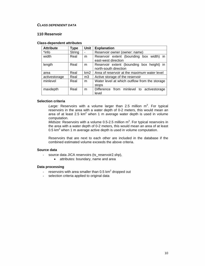
CLASS DEPENDENT DATA
110 Reservoir
Class-dependent attributes Attribute Type Unit Explanation *info String - Reservoir owner (owner: name) width Real m Reservoir extent (bounding box width) in
east-west direction length Real m Reservoir extent (bounding box height) in
north-south direction area Real km2 Area of reservoir at the maximum water level activestorage Real m3 Active storage of the reservoir minlevel Real m Water level at which outflow from the storage
stops maxdepth Real m Difference from minlevel to activestorage
level
Selection criteria Large: Reservoirs with a volume larger than 2.5 million m3. For typical reservoirs in the area with a water depth of 0-2 meters, this would mean an area of at least 2.5 km2 when 1 m average water depth is used in volume computation. Midsize: Reservoirs with a volume 0.5-2.5 million m3. For typical reservoirs in the area with a water depth of 0-2 meters, this would mean an area of at least 0.5 km2 when 1 m average active depth is used in volume computation. Reservoirs that are next to each other are included in the database if the combined estimated volume exceeds the above criteria.
Source data - source data JICA reservoirs (ts_reservoir2.shp),
• attributes: boundary, name and area
Data processing - reservoirs with area smaller than 0.5 km2 dropped out - selection criteria applied to original data

11
120 Floodwater_storage
Class-dependent attributes Attribute Type Unit Explanation *info String Storage owner (owner: name) width Real m Storage extent (bounding box width) in east-
west direction length Real m Storage extent (bounding box height) in
north-south direction area Real km2 Area of storage at the maximum water level activestorage Real m3 active storage of the reservoir minlevel Real m Water level at which flow to/from the storage
stops maxdepth Real m Difference from minlevel to water level at
activestorage volume
Selection criteria − same as for reservoirs (class 110)
Source data - source data Kampong Thom private reservoirs, Agriculture Office Kampong
Thom Province (kt_reservoir.shp) • attributes: boundary, owner, area
Data processing - no addition processing
210 Canal
Class-dependent attributes Attribute Type Unit Explanation width Real m Channel/opening width perpendicular to flow
direction length Real m Channel/opening length along flow minlevel Real m Channel bottom level maxdepth Real m Channel depth from minlevel to bank level crsection Real m2 Channel cross section area at maxlevel material String
Selection criteria Large: Canals with an average flow larger than 1m3/s, or a peak flow larger than 10m3/s. Channels with high water cross section larger than 10 m2 Midsize: All channels wider than 2 meters
Source data - no data
Data processing - no addition processing

12
211 Irrigation canal
Class-dependent attributes Attribute Type Unit Explanation width Real m Channel width perpendicular to flow direction length Real m Channel length along flow minlevel Real m Channel bottom level maxdepth Real m Channel depth from minlevel to bank level crsection Real m2 Channel cross section area at maxlevel material String - Bank material, if not earth
Selection criteria − same as canal (class 210)
Source data - source data JICA irrigation channel data (ts_irr_canal2.shp)
• all data included • attributes: mid-line, small/large size classification
- source data Chinit irrigation project channel data (added ts_reservoir2.shp) • all data included • attributes: mid-line, size: main/secondary/tertiary canal/drain
Data processing - simplified data to 10 meter resolution - split with catchment boundaries
220 Bridge
Class-dependent attributes Attribute Type Unit Explanation width Real m Channel/opening width perpendicular to flow
direction height Real m Height of bridge bottom from dry-season
water level length Real m Channel/opening length along flow minlevel Real m Bridge opening bottom level maxdepth Real m Typical maximum water depth under bridge crsection Real m2 Channel/opening cross section area at
maxlevel material String - Material
Selection criteria Large: Bridges longer than 30 meters Midsize: Bridges longer than 5 meters
Source data - source data JICA map road bridges (ts_rd_bridge.shp)
• all bridges included • attributes: location

13
- source data JICA map railroad bridges (ts_rr_bridge.shp) • all bridges included • attributes: location
Data processing − no additional processing
230 Culvert
Class-dependent attributes Attribute Type Unit Explanation *info String Culvert type, pipe/box width Real m Width perpendicular to flow direction height Real m Height of culvert opening length Real m Length along flow minlevel Real m Culvert bottom level maxdepth Real m Culvert maximum water depth crsection Real m2 Cross section area at maxdepth wldrop Real m Difference of height from start to end of
culvert material String Material, if not earth
Selection criteria - all culverts included
Source data - source data (ts_culvert2.shp)
• attributes: location, culvert type box/pipe, construction year
Data processing - Culverts with no completion year dropped out
240 Spillway
Class-dependent attributes Attribute Type Unit Explanation width Real m Channel/opening width perpendicular to flow
direction length Real m Channel/opening length along flow minlevel Real m2 Minimum water level for flow to occur over
structure maxdepth Real m2 Typical maximum water depth crsection Real m2 Cross-section area wldrop Real m Water level drop over the length of structure material String Bank material, if not earth
Selection criteria - all data included

14
Source data - field visit data from Chinit
• attributes: width, length, wldrop
Data processing - no additional processing
310 Dam
Class-dependent attributes Attribute Type Unit Explanation width Real m Width of structure/opening perpendicular to
flow direction height Real m Largest height of dam length Real m Length of flow path in structure along flow
direction crestlevel Real m Minimum water level for flow to occur over
structure material String - Timber/earth/stone/concrete/metal
Selection criteria Large: Dams with active reservoir volume larger than 2.5 million m3 Midsize: Dams with active reservoir volume between 0.5-2.5 million m3
Source data - source data JICA map (ts_dam_earth2.shp)
• attributes: boundary, material
Data processing - all data included - joined lines - simplified to 10 m resolution
320 Embankment
Class-dependent attributes Attribute Type Unit Explanation width Real m Width of structure height Real m Average height of embankment from ground
level length Real m Length of embankment crestlevel Real m Minimum water level for flow to occur over
structure material String - Timber/soil/concrete/metal
Selection criteria Large: Any embankment potentially catching water for more than 2.5 million m3, or, an embankment longer that 10 km. Midsize: Embankments higher than 1 m if longer than 2 km. Also, other embankments that potentially trap more than 0.5 million m3 of water.

15
Source data - source data JICA embankments (ts_levee3.shp)
• attributes: boundary, material, length
Data processing - joined lines - dropped out embankments shorter than 0.8 km, and not within distance of 0.5
km of a selected embankment - simplified to 10 m resolution - split with catchment boundaries
321 Road embankment (primary)
Class-dependent attributes Attribute Type Unit Explanation width Real m Width of structure height Real m Average height of embankment from ground
level length Real m Length of embankment crestlevel Real m Minimum water level for flow to occur over
structure material String - Timber/soil/concrete/metal
Selection criteria - all data included
Source data - source data JICA primary roads (ts_rdprimary2.shp)
• attributes: boundary, length
Data processing - split with catchment boundaries - set the crestlevel to 12 meters (equal to above flood)
322 Road embankment (other)
Class-dependent attributes Attribute Type Unit Explanation width Real m Width of structure height Real m Average height of embankment from ground
level length Real m Length of embankment crestlevel Real m Minimum water level for flow to occur over
structure material String - Timber/soil/concrete/metal
Selection criteria - all data included (no knowledge on embankment heights available)

16
Source data - source data JICA secondary roads (ts_rdsecondary2.shp)
• attributes: boundary, length
Data processing - simplified data to 25 meter resolution - split with catchment boundaries
323 Railroad embankment
Class-dependent attributes Attribute Type Unit Explanation width Real m Width of structure height Real m Average height of embankment from ground
level length Real m Length of embankment crestlevel Real m Minimum water level for flow to occur over
structure material String - Timber/soil/concrete/metal
Selection criteria - all data included
Source data - source data JICA railroads (ts_railway2.shp)
• attributes: boundary, length
Data processing - joined lines - simplified data to 25 meter resolution - split with catchment boundaries - set crestlevel to 12 (above flood)
324 Reservoir dike
Class-dependent attributes Attribute Type Unit Explanation width Real m Width of structure height Real m Largest height of dike from ground level length Real m Length of dike crestlevel Real m Minimum water level for flow to occur over
structure material String - Timber/earth/stone/concrete/metal
Selection criteria - see reservoir
Source data - source data Chinit irrigation project data (chinit_embankment.shp)
• attribute: boundary, width, length

17
Data processing - no additional processing
330 Gate
Class-dependent attributes Attribute Type Unit Explanation width Real m Width of gate perpendicular to flow direction height Real m Height of gate from bottom to max water level length Real m Length of flow path in gate along flow
direction minlevel Real m Min water level on which flow can occur
through the gate maxdepth Real m Typical maximum water depth for gate crsection Real m2 Cross section though which water can flow at
maxdepth material String - Timber/earth/stone/concrete/metal
Selection criteria Large: Gate with width of at least 3.0 meters Midsize: Gate with width of 1.0 to 3.0 meters
Source data - field survey data
Data processing - no additional processing
340 Weir
Class-dependent attributes Attribute Type Unit Explanation width Real m Width of weir perpendicular to flow direction height Real m Height of weir length Real m Length of weir flow path in flow direction crestlevel Real m Minimum water level for flow to occur over
structure wldrop Real m Water level drop (typical) material String - Timber/earth/stone/concrete/metal
Selection criteria Large: Weir with width of at least 30 meters Midsize: Weir with width of 2.0 to 30 meters
Source data - source data Chinit irrigation project data (chinit_weir.shp)
• attributes: length, wldrop, material
Data processing - no additional processing

18
350 Pumping station
Class-dependent attributes Attribute Type Unit Explanation minlevel Real m Minimum water level where the station can
work production Real m3/s Maximum pumping capacity
Selection criteria Large: Station with capacity of at least 2 m3/s Midsize: Station with capacity over 0.5 m3/s
Source data - no data
Data processing - no additional processing
360 Hydropower station
Class-dependent attributes Attribute Type Unit Explanation minlevel Real m Min water level on which flow can occur
through the structure maxdepth Real m Typical maximum water depth from minlevel maxflow Real m3 Maximum flow though structure on maximum
water level wldrop Real m Water level drop (maxlevel to bottom of
structure) production Real Gwh Annual hydropower production
Selection criteria Large: Station with production over 50 Gwh Midsize: Station with production less than 50 Gwh
Data processing - no additional processing
370 Measurement station
Class-dependent attributes Attribute Type Unit Explanation *info Real m Type of station: automatic/manual, measured
variable(s)
Selection criteria - all data stations included
Data processing - no additional processing

19
371 Hydrological station
Class-dependent attributes Attribute Type Unit Explanation *info Real m Type of station: automatic/manual, measured
variable(s)
Selection criteria - all data stations included
Source data - source data MOWRAM water level stations (river_station.shp)
• attributes: location, station id code, measured variables
Data processing - no additional processing
372 Meteorological station
Class-dependent attributes Attribute Type Unit Explanation *info Real m Type of station: automatic/manual, measured
variable(s)
Selection criteria - all data stations included
Source data - source data MPWT rainfall stations (rainfall_st.shp)
• attributes: location, station id, measured variables
Data processing - no additional processing
410 Fishing gear
Class-dependent attributes Attribute Type Unit Explanation production Real kg/a Approximate production in one year
Selection criteria - stationary gears included
Data processing - no additional processing

20
411 Dai fishery
Class-dependent attributes Attribute Type Unit Explanation width Real m Number of nets production Real kg/a Approximate production in one year
Selection criteria - all known dai fisheries included
Source data - satellite picture from Google Earth
• attributes: boundary, number of nets
Data processing - no additional processing
412 River barrage with bagnet or trap
Class-dependent attributes Attribute Type Unit Explanation width Real m Width of barrage production Real kg/a Approximate production in one year
Selection criteria Large: Barrages longer than 50 meters Midsize: Barrages between 10-50 meters
Data processing - no additional processing
413 Fence system fence
Class-dependent attributes Attribute Type Unit Explanation length Real m Length of associated fence system (main
fence part only) production Real kg/a Approximate production in one year
Selection criteria - all fences, traps and pens
Source data - digitized from aerial photos (fence_pen.shp, fence_trap.shp, fish_fence.shp),
Preak Toal area only • attributes: boundary, length

21
Data processing - no additional processing
414 Fence system pen
Class-dependent attributes Attribute Type Unit Explanation length Real m Length of associated fence system (main
fence part only) production Real kg/a Approximate production in one year
Selection criteria - all fences, traps and pens
Source data - digitized from aerial photos (fence_pen.shp, fence_trap.shp, fish_fence.shp),
Preak Toal area only • attributes: boundary, length
Data processing - no additional processing
413 Fence system rap
Class-dependent attributes Attribute Type Unit Explanation length Real m Length of associated fence system (main
fence part only) production Real kg/a Approximate production in one year
Selection criteria - all fences, traps and pens
Source data - digitized from aerial photos (fence_pen.shp, fence_trap.shp, fish_fence.shp),
Preak Toal area only • attributes: boundary, length
Data processing - no additional processing
420 Fishway
Class-dependent attributes Attribute Type Unit Explanation width Real m Channel width perpendicular to flow direction length Real m Channel length along flow (measured along
bank)

22
crestlevel Real m Minimum water level for flow to occur crsection Real m2 Channel cross section wldrop Real m Water level drop over the length of structure material String Bank material, if not earth
Selection criteria - all fishways
Source data - field trip data from Chinit area
• attributes: boundary, width, length, wldrop
Data processing - no additional processing
430 Aquaculture
Class-dependent attributes Attribute Type Unit Explanation area Real m2 Aquaculture area production Real kg/a Approximate production in year
Selection criteria - farms with annual production more than 10 tons per year
Source data - no data
Data processing - no additional processing
431 Pond fish farm
Class-dependent attributes Attribute Type Unit Explanation area Real m2 Aquaculture area production Real kg/a Approximate production in year
Selection criteria - same as for aquaculture (class 430)
Source data - no data
Data processing - no additional processing

23
432 Cage fish farm
Class-dependent attributes Attribute Type Unit Explanation area Real m2 Aquaculture area production Real kg/a Approximate production in year
Selection criteria - same as for aquaculture (class 430)
Source data - no data
Data processing - no additional processing
440 Fishing lot area
Class-dependent attributes Attribute Type Unit Explanation *name String Province and number area Real m2 Lot area production Real kg/a Approximate production in year
Selection criteria - all fishing lots included
Source data - source data MRC fishing lots from year 2001 (c_lot2001_commercial_3.shp)
• attributes: boundary, lot number, area code
Data processing - extracted commercial lots (type 2) from c_lot2001.shp - union of lots with same region code and lot number - simplified to 50 m resolution

24
450 Fish sanctuary
Class-dependent attributes Attribute Type Unit Explanation *name String Province and number area Real m2 Lot area
Selection criteria - all fish sanctuaries included
Source data - source data MRC fish sanctuaries from year 2001 (c_lot2001_sanctuary.shp)
• attributes: boundary
Data processing - extracted sanctuaries (type 3) from c_lot2001.shp - simplified to 50 m resolution
510 Reinforced bank
Class-dependent attributes Attribute Type Unit Explanation width Real m length Real m material String - Description of material used
Data processing - no additional processing
520 RipRap
Class-dependent attributes Attribute Type Unit Explanation width Real m Width across flow direction length Real m Length along flow direction material String - Description of material used
Selection criteria - ripraps associated with a structure already in the database
Source data - field trip data from Chinit area
• attributes: boundary, width, length, wldrop
Data processing - no additional processing

25
610 Rice field
Class-dependent attributes Attribute Type Unit Explanation area Real km2 Area of structure
Source data - source data JICA paddy field areas (ts_paddyfield5.shp)
• attributes: boundary, area
Data processing - simplified to 50 m resolution - split to catchment areas - areas smaller than 0.1 km2 removed
620 Field crops
Class-dependent attributes Attribute Type Unit Explanation area Real km2 Area of structure
Source data - source data JICA plantation areas (ts_fieldcrop2.shp)
• attributes: boundary, area
Data processing - simplified to 50 m resolution - areas smaller than 0.1 km2 removed - split to catchment areas
630 Plantation
Class-dependent attributes Attribute Type Unit Explanation area Real km2 Area of structure
Source data - source data JICA plantation areas (ts_plantation2.shp)
• attributes: boundary, area
Data processing - simplified to 50 m resolution - areas smaller than 0.1 km2 removed - split to catchment areas

26
640 Other agriculture
Class-dependent attributes Attribute Type Unit Explanation area Real km2 Area of structure
Source data - source data JICA agricultural areas (ts_otheragri2.shp)
• attributes: boundary, area
Data processing - simplified to 50 m resolution - areas smaller than 0.1 km2 removed - split to catchment areas
650 Irrigated area
Class-dependent attributes Attribute Type Unit Explanation area Real km2 Area of structure
Selection criteria - Irrigated areas with field area larger than 2.5 km2
Source data - source data MRC irrigated areas (ts_irriarea.shp)
• attributes: boundary, project name, area - source data Kampong Thom private reservoir areas (kt_irriarea.shp)
• attributes: boundary, area, owner name
Data processing - no additional processing
710 Dock/Harbour
Class-dependent attributes Attribute Type Unit Explanation length Real m Length of structure
Selection criteria - all data included
Source data - no data
Data processing - no additional processing

27
720 Breakwater
Class-dependent attributes Attribute Type Unit Explanation length Real m Length of structure
Selection criteria - breakwaters with length of at least 100 meters
Source data - no data
Data processing - no additional processing
730 Ferry
Class-dependent attributes Attribute Type Unit Explanation length Real m Length of structure
Selection criteria - all data included
Source data - source data JICA ferry lines (ts_ferry_line.shp)
Data processing - no additional processing
810 Point source
Class-dependent attributes Attribute Type Unit Explanation production Real m3/d Volume of water coming from outlet
Selection criteria - waste water flow of at least 100 m3/d, or P load of at least 0.1 kg/d, or N load
of at least 1 kg/d, or otherwise non-negligible point source.
Source data - no data
Data processing - no additional processing

28
811 Sewage treatment plant
Class-dependent attributes Attribute Type Unit Explanation production Real m3/d Volume of water coming from outlet
Selection criteria - with waste water flow of at least 100 m3/d
Source data - no data
Data processing - no additional processing
812 Sewage outlet
Class-dependent attributes Attribute Type Unit Explanation production Real m3/d Volume of water coming from outlet
Selection criteria - with waste water flow of at least 50 m3/d
Source data - no data
Data processing - no additional processing
813 Industrial sewage outlet
Class-dependent attributes Attribute Type Unit Explanation production Real m3/d Volume of water coming from outlet
Selection criteria - with waste water flow of at least 50 m3/d
Source data - no data
Data processing - no additional processing

29
814 Mine
Class-dependent attributes Attribute Type Unit Explanation *info String Mineral/material, type open-
pit/placer/quarry/sub-surface production Real tn Production of material processed/taken out
yearly
Selection criteria - all data included
Source data - source data MIME mine data (mine_mime2.shp)
Data processing - removed points outside Tonle Sap catchment areas
820 Diffuse source
Class-dependent attributes Attribute Type Unit Explanation *info String Type of source area Real km2 Area of source width Real - Number of units height Real kg Production per unit per year production Real units Total production per year
Source data - no data
Data processing - no additional processing
821 Scattered population
Class-dependent attributes Attribute Type Unit Explanation *info String Type of source, waste produced area Real km2 Area of source width Real - Number of people height Real kg Production per person per year production Real units Total production per year
Selection criteria - Village (“phum”) level division
Source data - population data from year 1998 (ts_phum2.shp)

30
- attributes: village position, number of persons
Data processing - no additional processing
AREA DATA The area table contains the following data:
- Tonle Sap catchment and subcatchment boundaries • Data source: MRC (tls_catchments.shp) • Attributes: boundary, name, area
- Medium flood extent boundaries o Data source: MRC (tls_catchments.shp) o Attributes: boundary, name, area
- Cambodian province boundaries (the provinces intesecting Tonle Sap catchment area)
o Data source: MRC (tls_provicnes.shp) o Attributes: boundary, name, area
SYSTEM COMPONENTS AND SETUP The database system is based on the following MySQL standard software components
• MySQL database server (version 5.0. community edition) • MySQL Query browser (version 1.1.20) • MySQL Administrator (version 1.1.9)
Additional tools were created in the project to enable transfer of GIS file data to and from the database server, and to allow data to be shared in internet. These are:
• BSViv tool to access database locally, and to import and export data from ESRI shapefile format
• BSMap tool (a java applet) to view data in internet • BSConn program (a www-server cgi-program) to retrieve data from database
server to BSMap applet The MySQL database server stores the database data and provides database services to client applications. The MySQL Query browser is an interactive tool that can be used to view and modify the data in the database in the computer that contains the database. Use of the tool requires knowledge of SQL. The Administrator tool is used to manage the database server, for example, create new users and create data backups. The programs are available at the MySQL www-site www.mysql.com free of charge. The Local database access tool "BSViv" can be used to view, add, and modify structure data on map-based windows application. Also import and export of data to ESRI shape file is possible. This feature can be used, for example, when larger amounts of structure data need to be moved to GIS system. The BSViv program utilizes an open-source GIS tool package called FWTools (version 1.0.7), which can be downloaded from http://fwtools.maptools.org.

31
The Internet access interface "BSApp" can be used to view database data remotely using an internet browser. To use BSApp a www-server with system html pages and bsconn- cgi-program needs to be setup. Installation of the system for local and internet access is described in the chapter 2 of the Built Structures Database User Manual.
MySQL tools-Administrator
- Query browser
MySQL server
Data
shape files
data import/ export with bsshapeio
local access Apache
www-server
bsconn.exe
Internet browser
BsMapApplet
internet
BsMapApplet
ClientServer
Figure 1: System components and connections
BSVIV APPLICATION FILES The BSViv application is implemented using a viv-language interpreter, that is developed in EIA Ltd. for simple graphical user interface implementation. The installation will setup the BSViv application under the installation directory to several subdirectories listed below with contents. Starting the program is done by running the "viv.exe" program with the "bs.ip"-file as a parameter. The viv (=program) subdirectory contains following files: bs.ip - program statup file bsmain.ip - main program file common.ip, rl*.ip - application program files viv.exe - ip-file interpreter
vivres.dll, vivbmp.dll - viv.exe resources and bitmaps, required by viv.exe rlgis.bmp - about dialog bitmap file
The map-subdirectory contains following files: tls_lake.* - lake and river data for BSViv application tls_subcatch_utm.* - subcatchment boundaries for BSViv application The doc-subdirectory contains following files: BSApp-help.doc - BSApp help file BSDB_manual.doc - Built structure database system user manual bsdb_techdoc.doc - this document The bsdb-subdirectory contains following files: bs0.sql - sql macro to create bs-database tables
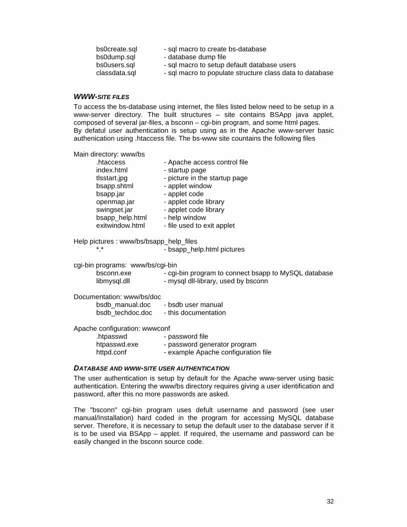
32
bs0create.sql - sql macro to create bs-database bs0dump.sql - database dump file bs0users.sql - sql macro to setup default database users classdata.sql - sql macro to populate structure class data to database
WWW-SITE FILES To access the bs-database using internet, the files listed below need to be setup in a www-server directory. The built structures – site contains BSApp java applet, composed of several jar-files, a bsconn – cgi-bin program, and some html pages. By defatul user authentication is setup using as in the Apache www-server basic authenication using .htaccess file. The bs-www site countains the following files Main directory: www/bs
.htaccess - Apache access control file index.html - startup page tlsstart.jpg - picture in the startup page bsapp.shtml - applet window bsapp.jar - applet code openmap.jar - applet code library swingset.jar - applet code library bsapp_help.html - help window exitwindow.html - file used to exit applet
Help pictures : www/bs/bsapp_help_files *.* - bsapp_help.html pictures cgi-bin programs: www/bs/cgi-bin bsconn.exe - cgi-bin program to connect bsapp to MySQL database libmysql.dll - mysql dll-library, used by bsconn Documentation: www/bs/doc bsdb_manual.doc - bsdb user manual bsdb_techdoc.doc - this documentation Apache configuration: wwwconf .htpasswd - password file htpasswd.exe - password generator program httpd.conf - example Apache configuration file
DATABASE AND WWW-SITE USER AUTHENTICATION The user authentication is setup by default for the Apache www-server using basic authentication. Entering the www/bs directory requires giving a user identification and password, after this no more passwords are asked. The "bsconn" cgi-bin program uses defult username and password (see user manual/Installation) hard coded in the program for accessing MySQL database server. Therefore, it is necessary to setup the default user to the database server if it is to be used via BSApp – applet. If required, the username and password can be easily changed in the bsconn source code.

33
SOURCE CODE FILES The bsconn c++ source files and BSApp java source files are included in the "BSSourceSetup.exe" installation package. The bsconn is compiled with Borland C++ builder 6, and the BsApp with Java 1.5.0_08.

34
APPENDIX A: GLOSSARY (Reference: http://www.nalms.org/glossary/glossary.htm) Channel
A course, such as a trench or aqueduct, through which water is moved or directed; the bed of a river or stream.
Conduit Any channel or pipe used for conducting the flow of water.
Culvert A hydraulically short conduit which conveys water e.g. through a roadway embankment or through some other type of flow obstruction below ground level.
Dam A barrier built across a valley or river for storing water.
Detention basin A basin or reservoir where water is stored for regulating a flood. It has outlets for releasing the flows during the floods.
Embankment A man-made earth structure constructed for the purpose of impounding water and/or carrying a roadway.
Fish ladder An inclined trough which carries water from above to below a dam so that fish can easily swim upstream.
Fishway A structure allowing fish to pass over vertical impediments. It may include special attraction devices, entrances, collection and transportation channels, a fish ladder, and an exit.
Gauge (gauging station) Specific locations on a stream where systematic observations of hydrologic data are obtained through mechanical or electrical means.
Intake A hydraulic structure built at the upstream end of the diversion canal; a tunnel or power plant for controlling the flow and preventing silt and debris from entering the diversion.
Levee A natural or man-made earthen barrier along the edge of a stream, river, or lake to prevent the flow of water out of its channel.
Reservoir An artificial lake, pond, tank, or basin (natural or man-made) into which water flows and is stored for future use.
Riprap A layer of large stones, broken rock, boulders, or precast blocks placed in random fashion on the upstream and downstream faces of embankment dams, on stream banks, on reservoir shores, on the sides of a channel, or on other land surfaces to protect them from erosion caused by current, wind, wave, and/or ice action.
Sluice An artificial channel for conducting water, with a valve or gate to regulate the flow.
Sluice gate A valve or gate used in a channel to regulate flow.

35
Spillway Section of a dam designed to permit water to pass over its crest; a weir or channel taking overflow from the dam; serves as a safety channel to prevent erosion of the dam.
Weir A dam, usually small, in a stream to raise the water level or divert its flow.
Weir (measurement) A notch or depression in a levee, dam, embankment, or other barrier across or bordering a stream, through which the flow of water is measured or regulated.
Weir (fish) A barrier constructed across a stream to divert fish into a trap.

36
APPENDIX B: TONLE SAP CATCHMENT STATISTICS (references. MRC hydrology report, 2005, WUP-FIN Tonle Sap modelling project, www.eia.fi/wup-fin) Catchment area ~ 95000 km2 Dry season lake ~ volume 1-2 km3, depth minimum 0.5 m, area 2500 km2 Rainy season lake ~ volume 50-80 km3, depth 6-9 m, area 13000-14500 km2 Lake retention capacity ~ 80 km3
80 % of sediments brought to lake by flood retained Average leaching from lake catchment area ~ 30 km3/a = 10 l/s/km2
Average volume flowing to lake outside catchment 40 km3/a Outflow from lake 7.5-8.5 months, 70.4 km3, or 3375 m3/s average for 8 months Inflow to lake from outside catchment area 40.7 km3, starting mid-May to mid-June, duration 3.5-4.5 months, 3860 m3/s average for 4 months
Precipitation ~ 1300 mm/a, typically no rain from December to February For rainy season, peak precipitation per month is typically over 300 mm/a, or about ¼ of the total yearly precipitation, three times the average precipitation. Pan evaporation ~ 2100 mm/a = 5.8 mm/d 1 cm water level change in dry season lake level is 2.5 km3

37
APPENDIX C: DATA DIRECTORY JICA data point data
− ts_rr_bridge.shp − ts_rd_bridge.shp − ts_culvert.shp − mine_mime.shp − ts_hystation.shp
JICA line data
− ts_ferry_line.shp − ts_railway2.shp − ts_canal.shp − ts_levee.shp − ts_rdprimary2.shp − ts_dam_earth.shp − ts_rdsecondary_aw.shp − ts_rdsecondary_dw.shp
JICA polygon data
− ts_reservoir.shp MRC data
− Tonle Sap catchment boundary − Tonle Sap subcatcment boundaries


![[Draft] Fish Migrations and Spawning Habits in the Mekong ...ifredi-cambodia.org/wp-content/uploads/2004/01/Chan Sokheng et al… · Singanouvong et. al. 1996b). Even the larval drift](https://img.pdfslide.us/doc/110x75/5f0d4a027e708231d4399bb0/draft-fish-migrations-and-spawning-habits-in-the-mekong-ifredi-sokheng-et.jpg)