Embed Size (px)
Citation preview

1. Added clarity regarding the local-serving definition;2. Added a distinction between the conceptual and functional aspects of the General Plan local
serving policies and3. Defined the term “maximum extent feasible”.
See amended Exhibits A and B.
Data Refinement
The San Martin Neighborhood Alliance, San Martin Planning Advisory Committee, and the Planning Commission had questions regarding the statistical data associated with past local serving uses in rural areas. Specifically, members of the public had questions regarding the inclusion of various institutional facilities within the statistical data and requested greater clarity regarding the methodology used to create statistical thresholds referenced in the Zoning Ordinance. Also the San Martin Neighborhood Alliance’s comments requested that missing data pertaining to traffic thresholds be added to the data.
The “Local Serving Data” document has been further refined and data collection, extrapolation, and use methodology added to the document (Exhibit C). Staff further researched project files to verify the information presented. Based on this additional research and data refinement, the 75% threshold numbers have slightly changed. The refinement of the data resulted in the exclusion of some data points that were previously included in the dataset. Based on further research it was determined that such uses do not qualify for the “local serving” criteria.
For institutional uses, there are now 9 data points, 6 of which are in the rural residential zone. For commercial uses, there are 7 data points. Staff recognizes that this is a small data set; however, it is the best available data to establish a local serving threshold for the County. The data would continue to be added to the data set as future use permits are approved by the County, which would continue to build the data set.
See amended Exhibit C.
Options for 75 Percentile Thresholds of Local Serving Data
The Planning Commission may consider one of the following options in its recommendation to the Board of Supervisors regarding the Zoning Ordinance threshold used to differentiate potential local serving uses with a larger size scale and intensity: (a) 75th percentile – all rural districts together (b) 66th percentile – all rural districts together (c) Rural Residential district separate from other rural districts (75th percentile).
1. Distinction Between Rural Residential (RR) and Other Rural Districts
An alternative proposed by residents in the San Martin area that was presented by staff at the May Planning Commission hearing is to separate the statistical data for “local serving” institutional uses within the Rural Residential zoning district from other rural zoning districts (Hillsides, Ranchlands, Agriculture).. The rationale and background history supporting this potential approach is discussed below:
The intent of the Rural Residential designation as stated in RLU-56 is to apply only to lands with a pattern of small, primarily developed parcels with established residential densities of at least 1 dwelling
2

per 10 acres, and aggregations of small parcels large enough to be considered more than mere random cluster or rural development on substandard parcels. The Rural Residential policies stem from the adoption of the 1980 General Plan, which established a comprehensive Land Use map and element, complete with policies for each land use designation. One of the fundamental roles of the Land Use Plan map was and remains that of implementing countywide growth management policies and requires lands outside city Urban Service Areas to remain in low density non-urban uses such as agriculture and resource conservation areas. To that end, minimum lot sizes for purposes of subdivision were established to allow densities of 20 acres per parcel for Hillsides, Ranchlands, Agriculture, and Open Space Reserve.
However, the County created the Rural Residential designation in recognition of the many existing areas of already subdivided and developed property where residential densities were significantly higher than those established in the 1980 General Plan, primarily for San Martin. The Rural Residential designation was intended to apply only to those areas deemed to have significant aggregations of substandard parcels, with unincorporated community primarily residential in character.
Evaluating local serving uses in Rural Residential designations distinct from other rural land use designations (Hillsides, Agriculture, Ranchlands, Open Space Reserve) would be supported by policy differences in the desired levels of protection from impacts related to the size, scale and intensity of development in the Rural Residential area compared to Hillside, Ranchlands, Agriculture and Open Space areas.
Table 1.1 in Amended Exhibit C includes the 75th percentile values of the Rural Residential Zoning Districts separate from the other rural districts of the County, also listed here below:
Table 1.1. Institutional Thresholds (75th Percentile) for Local-Serving Indicators
Maximum Number of People Building Square Footage
Rural Residential (RR) District Institutional Uses 50 (daily)
6,510 220 (special events)
Agricultural (A), Agricultural Ranchlands (AR) and Hillside (HS) Districts Institutional Uses 70 (daily)
8,480 320 (special events)
As noted above, providing a separating data set for the Rural Residential Zoning District is consistent with the residential density as allowed for in the County General Plan outside City urban service areas. The characteristics of Hillsides and Ranchlands development are different than Rural Residential areas of the County. However, the primary drawback of using this option is that there are less datapoints in the statistical analysis (6 datapoints total). Combining all districts includes 9 datapoints.
2. All Rural Districts Data Combined
This is the initial approach proposed by staff to address a clear quantitative way of defining what is considered to be a local serving use (based on size, scale and intensity) that is local serving in nature
3
(rural, not urbanized development) from prior data (approved projects) accumulated from 1980 to 2014 in consistency with the County General Plan and Zoning Ordinance local serving provisions. A benefit of this approach is that there are more data points to establish thresholds when taking into account all the rural districts data.
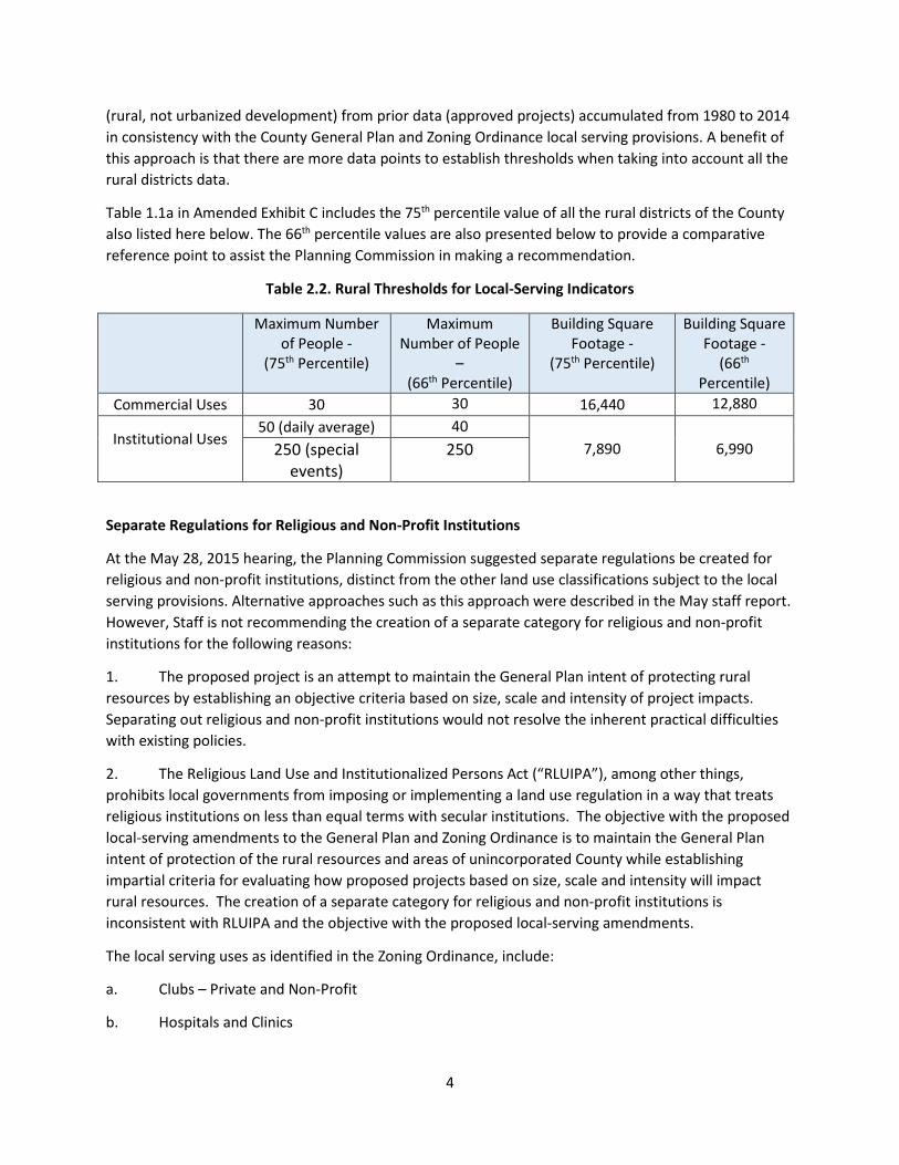
Table 1.1a in Amended Exhibit C includes the 75th percentile value of all the rural districts of the County also listed here below. The 66th percentile values are also presented below to provide a comparative reference point to assist the Planning Commission in making a recommendation.
Table 2.2. Rural Thresholds for Local-Serving Indicators
Maximum Number of People -
(75th Percentile)
Maximum Number of People
– (66th Percentile)
Building Square Footage -
(75th Percentile)
Building Square Footage -
(66th Percentile)
Commercial Uses 30 30 16,440 12,880
Institutional Uses
50 (daily average) 40 7,890 6,990 250 (special
events) 250
Separate Regulations for Religious and Non-Profit Institutions
At the May 28, 2015 hearing, the Planning Commission suggested separate regulations be created for religious and non-profit institutions, distinct from the other land use classifications subject to the local serving provisions. Alternative approaches such as this approach were described in the May staff report. However, Staff is not recommending the creation of a separate category for religious and non-profit institutions for the following reasons:
1. The proposed project is an attempt to maintain the General Plan intent of protecting rural resources by establishing an objective criteria based on size, scale and intensity of project impacts. Separating out religious and non-profit institutions would not resolve the inherent practical difficulties with existing policies.
2. The Religious Land Use and Institutionalized Persons Act (“RLUIPA”), among other things, prohibits local governments from imposing or implementing a land use regulation in a way that treats religious institutions on less than equal terms with secular institutions. The objective with the proposed local-serving amendments to the General Plan and Zoning Ordinance is to maintain the General Plan intent of protection of the rural resources and areas of unincorporated County while establishing impartial criteria for evaluating how proposed projects based on size, scale and intensity will impact rural resources. The creation of a separate category for religious and non-profit institutions is inconsistent with RLUIPA and the objective with the proposed local-serving amendments.
The local serving uses as identified in the Zoning Ordinance, include:
a. Clubs – Private and Non-Profit
b. Hospitals and Clinics
4
c. Manufacturing: Small Scale Rural
d. Non-Profit Institutions
e. Religious Institutions
f. Retail Sales and Services – Local Serving
g. Schools
h. Commercial Uses in the San Martin Commercial and Industrial Use Permit Areas
Recommended Actions
The Planning Commission must make a determination of which Local Serving Data option to recommend to the Board of Supervisors for adoption as follows:
(a) 75th percentile – all rural districts together
(b) 66th percentile – all rural districts together
(c) Rural Residential district separate from other rural districts (75th percentile)
Exhibits
Amended Exhibit A – Modifications to the General Plan
Amended Exhibit B – Modifications to the Zoning Ordinance
Amended Exhibit C – Modifications to the Local Serving Data
Exhibit D – May Meetings Notes & Minutes
5

This page has been intentionally left blank.

Amended Exhibit A
Proposed General Plan Amendments
for Local Serving Uses

This page has been intentionally left blank.

Local-serving Uses Proposed General Plan Amendments July 13, 2015
Existing Regulatory Framework Proposed Changes
GENERAL PLAN
STRATEGY #1: PRESERVE THE RESOURCES AND CHARACTER OF RURAL LANDS Low Density, Non-Urban Land Use Under the “joint urban development policies,” the 15 cities are responsible for managing urban growth through various means, including infill, expansion if appropriate, or both, but only on lands within each city’s established USA boundary. On lands outside of cities’ USAs, it is incumbent upon the County to allow only nonurban, low density uses.
In allowing only non-urban uses and densities outside USAs, the County simultaneously: • maintains the integrity of the Urban Service Area concept;• conserves valuable natural resources;• avoids natural hazards and constraints which could pose a threat topublic health, safety, and welfare, such as landslides and earthquake faults; • minimizes demand for public services and the costs to the general publicof providing and maintaining roads and services; • helps preserve scenic qualities of the rural landscape; and• prevents unwanted or premature development that would precludeefficient conversion to urban uses and densities in areas suitable and intended for future annexation.
In order to help preserve rural character and scenic values of the rural unincorporated area, application of design guidelines may also be of benefit. Design or development guidelines can help further carry out the intent of the General Plan by assuring that (a) the development is consistent with community goals to preserve rural character; (b) is not obtrusive or in conflict with the architecture of its surroundings; and, (c) minimizes other potential environmental impacts.
In allowing only non-urban uses and densities outside USAs, the County simultaneously: • maintains the integrity of the Urban Service Area concept;• conserves valuable natural resources;• avoids natural hazards and constraints which could pose a threat topublic health, safety, and welfare, such as landslides and earthquake faults; • minimizes demand for public services and the costs to the generalpublic of providing and maintaining roads and services; • helps preserve scenic qualities of the rural landscape; and• prevents unwanted or premature development that would precludeefficient conversion to urban uses and densities in areas suitable and intended for future annexation.
With the exception of unique and specialized land uses (Strategy #3), the types of non-urban, low density uses allowed in the rural areas consist of rural residential and commercial, institutional, and industrial uses that either (a) are directly associated with open space, resources, and agriculture found in the rural areas, such as wineries, camps and retreats, or surface mining operations, or (b) are of a size, scale and intensity intended to provide goods and services to the resident rural community. These local serving uses are necessary to provide support services to the resident rural community, while preventing urban scale development. The County evaluates these local-serving uses based on size, scale and intensity, and not on the origins of users.
In order to help preserve rural character and scenic values of the rural unincorporated area, application of design guidelines may also be of benefit. Design or development guidelines can help further carry out the intent of the General Plan by assuring that (a) the development is
Page 1 of 2 Santa Clara County Planning Office

Local-serving Uses Proposed General Plan Amendments July 13, 2015
Existing Regulatory Framework Proposed Changes consistent with community goals to preserve rural character; (b) is not obtrusive or in conflict with the architecture of its surroundings; and, (c) minimizes other potential environmental impacts.
RURAL RESIDENTIAL AREAS - Allowable Uses Policy R-LU 57 Residential, agricultural and open space uses are the primary uses. Commercial, industrial and institutional uses may be established only where they serve the needs of the resident population and result in a net overall reduction of travel demand.
Residential, agricultural and open space uses are the primary uses. Commercial, industrial and institutional uses may be established only where they are sized to be local-serving in nature.serve the needs of the resident population and do not result in significant traffic impacts to the community.
R-LU 119
Non-residential development in the San Martin Planning Area shall conform to adopted development and design guidelines for the San Martin Community.
R-LU 119 Non-residential development in the San Martin Planning Area shall conform to adopted development and design guidelines for the San Martin Community contained within the “San Martin Integrated Design Guidelines.”
SAN MARTIN PLANNING AREA - Commercial Use Permit Area Policy R-LU 127 New commercial land uses within the commercial or industrial use permit areas shall be of a local-serving nature, with the exception of properties immediately adjacent to the San Martin Avenue / Highway 101 freeway interchange that are east of Murphy Avenue, where uses may be allowed which are not necessarily of a local-serving nature. Local-serving uses shall be defined as only those uses which provide support services for agriculture or satisfy the local day-to-day commercial needs of the residents of San Martin and do not result in significant additional traffic from outside the community. [Amended Dec. 5, 1995; File #: 6009-00-00-95GP; Mar. 9, 1999; File# 7200-00-00-98GP]
New commercial land uses within the commercial or industrial use permit areas shall be sized to be of a local-serving nature, with the exception of properties immediately adjacent to the San Martin Avenue / Highway 101 freeway interchange that are east of Murphy Avenue, where uses may be allowed which are not necessarily of a local-serving nature. Local-serving uses shall be defined as only those uses which provide support services for agriculture or satisfy the local day-to-day commercial needs of the residents of San Martin and do not result in significant additional traffic from outside the community.
Page 2 of 2 Santa Clara County Planning Office

Amended Exhibit B
Local Serving Uses
Proposed Zoning Ordinance Amendments

This page has been intentionally left blank.
Ordinance No. NS–1200.###
AN ORDINANCE OF THE BOARD OF SUPERVISORS OF THE
COUNTY OF SANTA CLARA AMENDING APPENDIX I, ZONING, OF THE COUNTY OF SANTA CLARA ORDINANCE CODE RELATING TO
LOCAL-SERVING USES IN RURAL AREAS
SUMMARY
This ordinance revises Appendix I, Zoning, of the County of Santa Clara Ordinance Code relating to local serving uses in rural areas.
THE BOARD OF SUPERVISORS OF THE COUNTY OF SANTA CLARA
ORDAINS AS FOLLOWS:
SECTION 1: Section 2.20.010 of Chapter 2.10, Article 2 of Appendix I, Zoning, of the County of Santa Clara Ordinance Code, is amended as follows (additions are underlined, deletions overstruck):
§ 2.20.010 Purposes
The intent of the rural base districts is to maintain and preserve the predominantly rural character of lands to which they are applied. The base districts further regulate the type of land uses and intensity of development permitted in rural areas in a manner that implements the general plan and which protects natural resources and maintains compatibility between uses.
This chapter defines the allowable land uses and development standards for each of the rural base districts, which include the A “Exclusive Agriculture,” AR “Agricultural Ranchlands,” HS “Hillsides,” and RR “Rural Residential” districts. The specific purposes of each of these base districts are described below.
A. A Exclusive Agriculture. The purpose of the Exclusive Agriculture district, also known as the A district, is to preserve and encourage the long-term viability of agriculture and agricultural lands, recognizing the vital contributions agriculture makes to the economy and quality of life within the county. The intent of this district is to reserve those lands most suitable for agricultural production for agricultural and appropriate related uses. This zoning district will provide stability for ongoing agricultural operations and provide for new uses necessary to support a viable local agriculture industry. This district is also intended to retain in open space uses those lands which may be suitable for future urbanization until such time as they are included within a city’s urban service area and public

facilities and services can be economically provided, consistent with community plans and objectives. This district is meant to apply to all portions of the county designated as Agriculture: Large-Scale, Agriculture: Medium-Scale, and Open Space Reserve in the general plan. Note that § 2.20.050 applies to this district.
B. AR Agricultural Ranchlands. The purpose of the Agricultural Ranchlands district, also known as the AR district, is to preserve ranching, the natural resources, and the rural character of the areas to which it applies. Permitted uses include ranching or agriculture, low-intensity recreation, mineral extraction, and land in its natural state. Very-low-intensity residential, commercial, industrial and institutional uses may also be allowed if they are sized to primarily serve the rural ranchland residents or are necessary for the enhancement and protection of the natural resources of the area and do not require a substantially higher level of service than presently provided. This district is meant to apply to all parcels designated Ranchlands in the general plan. Note that § 2.20.060 applies to this district.
C. HS Hillside. The purpose of the Hillside district, also known as the HS district, is to preserve mountainous lands unplanned or unsuited for urban development primarily in open space and to promote those uses which support and enhance a rural character, which protect and promote wise use of natural resources, and which avoid the risks imposed by natural hazards found in these areas. These lands are watersheds and may also provide such important resources as minerals, forests, animal habitat, rare or locally unique plant and animal communities, historic and archeological sites, scenic beauty, grazing lands, and recreational areas. Additionally, lands zoned Hillside define the setting or viewshed for the urban area of the county.
Development shall be limited to avoid the need for public services and facilities. Permitted uses include agriculture and grazing, very low density residential use, low density, low intensity recreation, mineral and other resource extraction, and land in its natural state. Low-intensity commercial, industrial, and institutional uses may also be allowed if they require a remote, rural setting and are sized in order to primarily serve the rural residents or community, or if they support the recreational or productive use, study, appreciation, or enhancement of the natural environment. Clustering of development, particularly residential, is encouraged in order to preserve contiguous open space and achieve efficiency in the provision of access to dwellings. This district is meant to apply to all parcels designated Hillside in the general plan. Note that § 2.20.070 applies to this district.
D. RR Rural Residential. The purpose of the Rural Residential district, also known as the RR district, is to permit rural residential development in certain limited unincorporated areas of the county designated by the general plan. Residential, agricultural and open space uses are the primary uses intended within the district. Agriculture-related uses that are not permitted by right may also be
Ord NS-1200.### Redline Local-Serving Rural (05/15/15 draft) Page 2 of 22
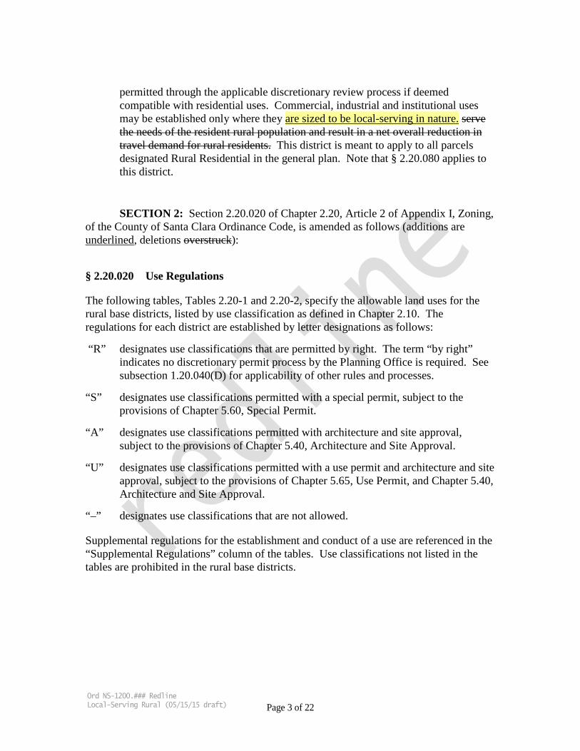
permitted through the applicable discretionary review process if deemed compatible with residential uses. Commercial, industrial and institutional uses may be established only where they are sized to be local-serving in nature. serve the needs of the resident rural population and result in a net overall reduction in travel demand for rural residents. This district is meant to apply to all parcels designated Rural Residential in the general plan. Note that § 2.20.080 applies to this district.
SECTION 2: Section 2.20.020 of Chapter 2.20, Article 2 of Appendix I, Zoning, of the County of Santa Clara Ordinance Code, is amended as follows (additions are underlined, deletions overstruck):
§ 2.20.020 Use Regulations
The following tables, Tables 2.20-1 and 2.20-2, specify the allowable land uses for the rural base districts, listed by use classification as defined in Chapter 2.10. The regulations for each district are established by letter designations as follows:
“R” designates use classifications that are permitted by right. The term “by right” indicates no discretionary permit process by the Planning Office is required. See subsection 1.20.040(D) for applicability of other rules and processes.
“S” designates use classifications permitted with a special permit, subject to the provisions of Chapter 5.60, Special Permit.
“A” designates use classifications permitted with architecture and site approval, subject to the provisions of Chapter 5.40, Architecture and Site Approval.
“U” designates use classifications permitted with a use permit and architecture and site approval, subject to the provisions of Chapter 5.65, Use Permit, and Chapter 5.40, Architecture and Site Approval.
“–” designates use classifications that are not allowed.
Supplemental regulations for the establishment and conduct of a use are referenced in the “Supplemental Regulations” column of the tables. Use classifications not listed in the tables are prohibited in the rural base districts.
Ord NS-1200.### Redline Local-Serving Rural (05/15/15 draft) Page 3 of 22

Table 2.20-1
RESIDENTIAL USES IN RURAL BASE DISTRICTS
R S A U –
Permitted by Right Special Permit (Ch 5.60) ASA (Ch 5.40) Use Permit/ ASA (Ch 5.65, 5.40) Not Permitted
USE CLASSIFICATIONS ZONING Supplemental A AR HS RR Regulations
Residences: Single-Family R R R R Note 1 Residential Accessory Structures & Uses R R R R § 4.20.020 Agricultural Employee Housing
Short Term S S S S § 4.10.040, Note 2 Long Term U R U U § 4.10.040, Note 2, Note 3
(AR) Community Care
Limited R R R R § 4.10.090, Note 4 Expanded U U U U § 4.10.090, Note 5
Domestic Animals Dogs & Cats R R R R Note 6 Other (see Ag: Livestock, Table 2.20-2)
Home Occupations General R R R R § 4.10.180 Expanded S S S S § 4.10.180, Note 7
Residential – Communal Institutional U U U U § 4.10.300, Note 8, Secondary Dwellings R R R R § 4.10.340, Notes 1, 9 Temporary Residences / Construction R R R R § 4.10.380
NOTES: 1. Single-family dwellings, including certain additions, and new secondary dwellings, may be
subject to the building site approval provisions of Section C12-300 et seq. of the County Ordinance Code.
2. Agricultural employee housing units may, on a limited basis, be used to accommodate overnight tourist stays. See subsection 4.10.395(C)(2) for criteria and permitting requirements.
3. On lots 10 acres or larger in AR districts, a second one-family dwelling for agricultural employee housing is allowed by right. Such agricultural employee housing unit shall not be subject to the supplemental use regulations of § 4.10.040.
4. Facilities qualifying as “Large-Family Day-Care Homes,” serving between 7 and 14 children, are subject to an administrative permit, per the provisions of Division B24 of the County Ordinance Code.
5. Not a permitted use in areas with the “Agriculture-Large Scale” land use plan designation of the general plan.
Ord NS-1200.### Redline Local-Serving Rural (05/15/15 draft) Page 4 of 22

6. Not to exceed two (2) dogs and five (5) cats over four months of age on parcels less than five acres, or three (3) dogs and five (5) cats over four months of age on parcels five acres or more, unless the required permit is secured pursuant to Division B31 of the Ordinance Code.
7. Expanded home occupations permitted on lots one-acre or larger. For additional applicable criteria, see § 4.10.180.
8. In rural districts, the floor area of Residential – Communal Institutional uses shall be limited to 10,000 square feet or less.
9. Three classes of detached secondary dwellings are subject to the special permit process: (a) those exceeding the permissible separation between primary and secondary dwelling, (b) those attached to an accessory building where cumulative floor area exceeds the allowed area specified for secondary dwellings, and (c) those necessitating separate driveway access. See § 4.10.340(D) for more complete information.
Table 2.20-2
NON-RESIDENTIAL USES IN RURAL BASE DISTRICTS
R S A U –
Permitted by Right Special Permit (Ch 5.60) ASA (Ch 5.40) Use Permit/ ASA (Ch 5.65, 5.40) Not Permitted
USE CLASSIFICATIONS ZONING Supplemental A AR HS RR Regulations
Agriculture General R R R R Livestock R R R R Note 1 (HS)
Agricultural Accessory Structures/ Uses R R R R § 4.20.020 Agricultural Equipment Sales/ Services A – – – Agricultural Processing
Small Scale R R R R § 4.10.030 Medium Scale A – – – § 4.10.030 Large Scale U – – – § 4.10.030
Agricultural Research A – – – Agricultural Sales
Limited R R R R § 4.40.110 (Signs) Farmers’ Markets U U – –
Agriculturally Related Entertainment & Commercial Uses
U – – – § 4.10.050
Aircraft Landing Strips – Private U U – – Note 2 Antennas – Commercial
Minor A A A A Major U U U U
Ord NS-1200.### Redline Local-Serving Rural (05/15/15 draft) Page 5 of 22

Table 2.20-2
NON-RESIDENTIAL USES IN RURAL BASE DISTRICTS
R S A U –
Permitted by Right Special Permit (Ch 5.60) ASA (Ch 5.40) Use Permit/ ASA (Ch 5.65, 5.40) Not Permitted
USE CLASSIFICATIONS ZONING Supplemental A AR HS RR Regulations
Bed & Breakfast Inns U U U U § 4.10.060, Note 3 Butcheries U U – – Camps & Retreats U U U U § 4.10.070, Note 4 Cemeteries U U U U § 4.10.080, Note 4 Churches [See “Religious Institutions”] Clubs – Private & Nonprofit U U U U Note 5 § 2.20.090 Community Care
Limited R R R R § 4.10.090, Note 6 Expanded U U U U § 4.10.090, Note 4
Dairies U U – – § 4.10.110 Entertainment – Seasonal Outdoor – – U – § 4.10.120 Feed Lots U U – – § 4.10.130 Golf Courses & Country Clubs U – U U § 4.10.140, Note 4 Golf Driving Ranges U – – U § 4.10.150, Note 4 Helipads – – U – § 4.10.160 Historic Structures – Use Conversion A A A A § 4.10.170 Hospitals & Clinics U U U U § 4.10.190, Notes 4 & 5
§ 2.20.090 (AR, HS, RR Districts), § 4.10.190 (A Districts), Note 4
Hunting & Fishing Preserves U R – – Note 7 Informational Displays
Small R – – – Large U – – –
Kennels – Commercial U U U U § 4.10.200 Laboratories and Testing Services (Limited)
U – – –
Livestock Auction Yards U U – – § 4.10.210 Manufacturing : Small Scale Rural A U – – Note 5 § 2.20.090 Museums U U U U Note 8
Ord NS-1200.### Redline Local-Serving Rural (05/15/15 draft) Page 6 of 22

Table 2.20-2
NON-RESIDENTIAL USES IN RURAL BASE DISTRICTS
R S A U –
Permitted by Right Special Permit (Ch 5.60) ASA (Ch 5.40) Use Permit/ ASA (Ch 5.65, 5.40) Not Permitted
USE CLASSIFICATIONS ZONING Supplemental A AR HS RR Regulations
Mushroom Farms U U – U § 4.10.220 Nonprofit Institutions U U U U § 4.10.230, Notes 4, 5 &
19 § 2.20.090 (AR, HS, RR Districts), § 4.10.230 (A Districts), Notes 4 & 19
Nurseries Retail U U U U Note 9 Wholesale R R R U Note 9
Offices (Limited) U – – – Note 10 Oil & Gas Extraction U U U U Poultry and Egg Farms – Commercial U U – U § 4.10.240 Radio-Controlled Model Aircraft Facilities
U – – – § 4.10.250
Reception Facilities U U U U § 4.10.260 Recreational Playgrounds & Sports Fields
U U U U § 4.10.270 (A Zoning District)
Recreational Vehicle Parks – – U U § 4.10.280 Recycling Facilities
Collection Facilities – Consumer Recycling
R R R R § 4.10.285
Recycling/ Processing Facilities –Consumer Waste
– – – –
Concrete, Asphalt & Soil Recycling U U U U Note 11 Composting & Wood Recycling U U U U Hazardous Materials – – – –
Religious Institutions U U U U § 4.10.290, Notes 4, 5 & 19 § 2.20.090 (AR, HS, RR Districts), § 4.10.290 (A Districts), Notes 4 & 19
Restaurants & Bars (Limited) – U U – Note 12 Retail Sales & Services: Local-Serving – U U – § 4.10.310, Note 5 Rodeos and Equestrian Event Facilities U U – – § 4.10.320
Ord NS-1200.### Redline Local-Serving Rural (05/15/15 draft) Page 7 of 22
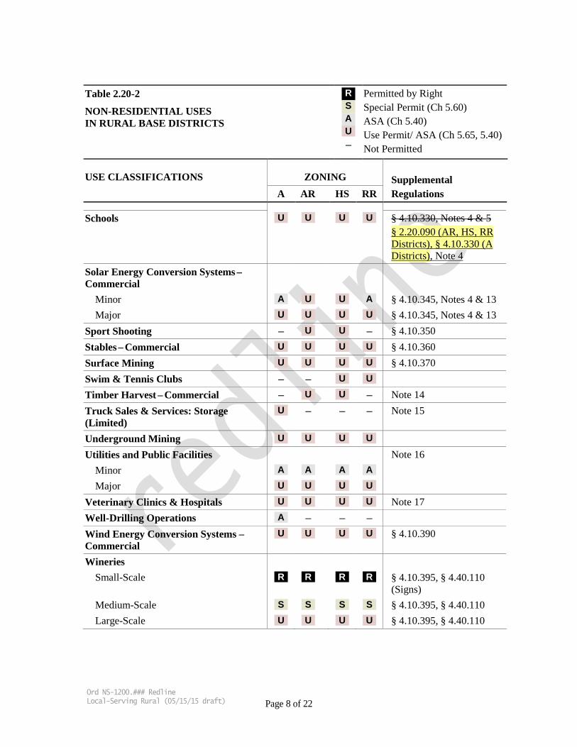
Table 2.20-2
NON-RESIDENTIAL USES IN RURAL BASE DISTRICTS
R S A U –
Permitted by Right Special Permit (Ch 5.60) ASA (Ch 5.40) Use Permit/ ASA (Ch 5.65, 5.40) Not Permitted
USE CLASSIFICATIONS ZONING Supplemental A AR HS RR Regulations
Schools U U U U § 4.10.330, Notes 4 & 5 § 2.20.090 (AR, HS, RR Districts), § 4.10.330 (A Districts), Note 4
Solar Energy Conversion Systems – Commercial
Minor A U U A § 4.10.345, Notes 4 & 13 Major U U U U § 4.10.345, Notes 4 & 13
Sport Shooting – U U – § 4.10.350 Stables – Commercial U U U U § 4.10.360 Surface Mining U U U U § 4.10.370 Swim & Tennis Clubs – – U U Timber Harvest – Commercial – U U – Note 14 Truck Sales & Services: Storage (Limited)
U – – – Note 15
Underground Mining U U U U Utilities and Public Facilities Note 16
Minor A A A A Major U U U U
Veterinary Clinics & Hospitals U U U U Note 17 Well-Drilling Operations A – – – Wind Energy Conversion Systems –Commercial
U U U U § 4.10.390
Wineries Small-Scale R R R R § 4.10.395, § 4.40.110
(Signs) Medium-Scale S S S S § 4.10.395, § 4.40.110 Large-Scale U U U U § 4.10.395, § 4.40.110
Ord NS-1200.### Redline Local-Serving Rural (05/15/15 draft) Page 8 of 22

Table 2.20-2
NON-RESIDENTIAL USES IN RURAL BASE DISTRICTS
R S A U –
Permitted by Right Special Permit (Ch 5.60) ASA (Ch 5.40) Use Permit/ ASA (Ch 5.65, 5.40) Not Permitted
USE CLASSIFICATIONS ZONING Supplemental A AR HS RR Regulations
Wireless Telecommunication Facilities Co-location A A A A § 4.10.400, Note 18 Minor A A A A § 4.10.400 Major U U U U § 4.10.400
NOTES: 1. Livestock breeding, raising and keeping is limited in HS districts as follows: Not more than three
(3) large animals or six (6) medium animals per acre as a matter of right, or a proportional combination totaling three (3) animal units where each large animal constitutes one (1) animal unit, and each medium animal constitutes 0.5 animal unit. Special permit required for numbers of large and medium animals exceeding these limits. There are no specified numerical limits for small animals.
2. Landing strip, including approach and departure zones, shall be located a safe distance from residential development to prevent significant hazard.
3. Bed and breakfast inns ancillary to on-site wineries, agricultural sales operations or other agriculturally related uses shall be subject to a special permit, in lieu of a use permit, provided they are situated within the primary residence on the property. Bed and breakfast inns are prohibited within the Los Gatos Hillside Specific Plan area, except as provided under the classification Historic Structures–Use Conversion.
4. Not a permitted use in areas with the “Agriculture-Large Scale” land use plan designation of the general plan.
5. The use shall be limited in scale and shall primarily serve the local (rural) community. The location shall be accessible and convenient to the local population to be served.
5. [Reserved]
6. Facilities qualifying as “Large-Family Day-Care Homes,” serving between 7 and 14 children, are subject to an administrative permit, per the provisions of Division B24 of the County Ordinance Code.
7. The minimum lot size for hunting preserves shall be one hundred sixty (160) acres.
8. Museums in rural districts shall be limited in scale and must relate to the locally significant cultural, historical or social themes of the rural area.
9. The size of buildings for on-site sales and ancillary office associated with nurseries shall be kept to a minimum.
10. Offices ancillary to a permitted agricultural activity in A districts that contain no more than 2,400 square feet of floor area are allowed as a matter of right. Offices larger than 2,400 square feet are subject to a use permit.
Ord NS-1200.### Redline Local-Serving Rural (05/15/15 draft) Page 9 of 22
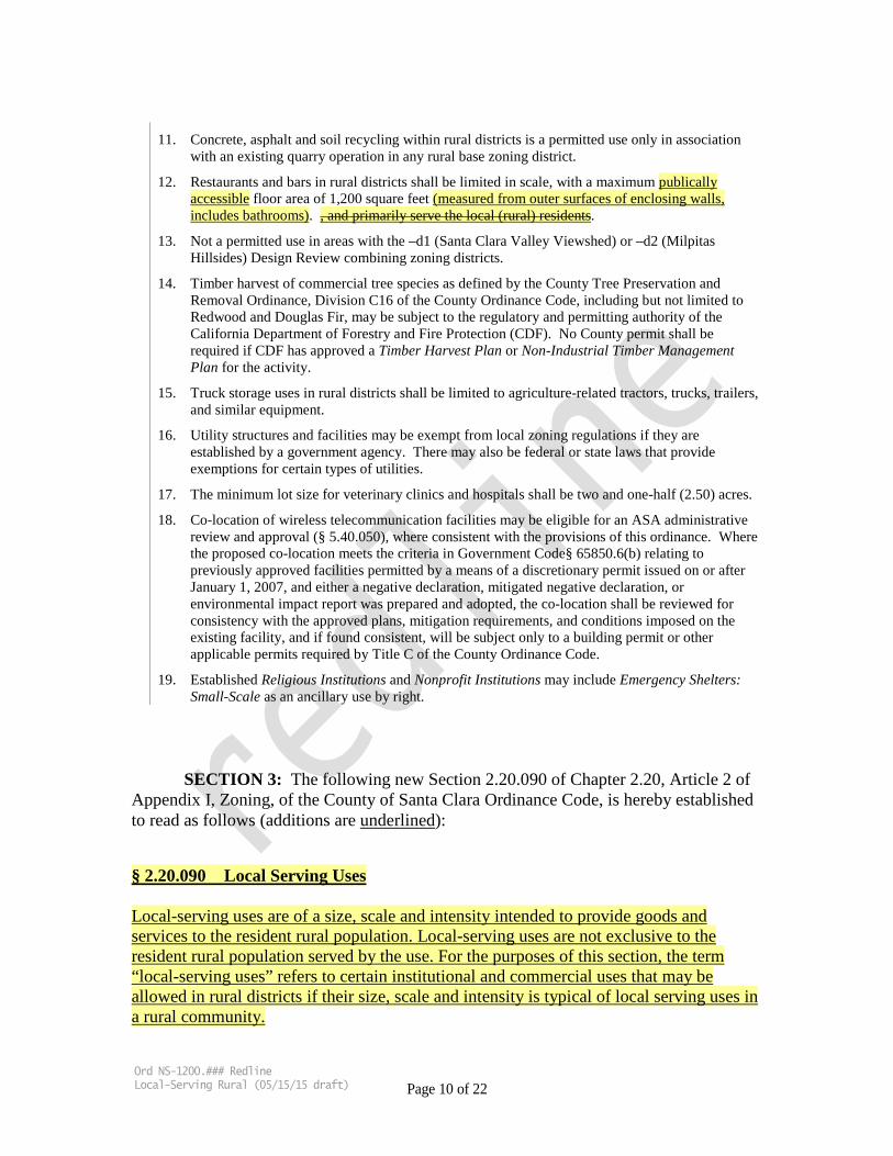
11. Concrete, asphalt and soil recycling within rural districts is a permitted use only in association with an existing quarry operation in any rural base zoning district.
12. Restaurants and bars in rural districts shall be limited in scale, with a maximum publically accessible floor area of 1,200 square feet (measured from outer surfaces of enclosing walls, includes bathrooms). , and primarily serve the local (rural) residents.
13. Not a permitted use in areas with the –d1 (Santa Clara Valley Viewshed) or –d2 (Milpitas Hillsides) Design Review combining zoning districts.
14. Timber harvest of commercial tree species as defined by the County Tree Preservation and Removal Ordinance, Division C16 of the County Ordinance Code, including but not limited to Redwood and Douglas Fir, may be subject to the regulatory and permitting authority of the California Department of Forestry and Fire Protection (CDF). No County permit shall be required if CDF has approved a Timber Harvest Plan or Non-Industrial Timber Management Plan for the activity.
15. Truck storage uses in rural districts shall be limited to agriculture-related tractors, trucks, trailers, and similar equipment.
16. Utility structures and facilities may be exempt from local zoning regulations if they are established by a government agency. There may also be federal or state laws that provide exemptions for certain types of utilities.
17. The minimum lot size for veterinary clinics and hospitals shall be two and one-half (2.50) acres.
18. Co-location of wireless telecommunication facilities may be eligible for an ASA administrative review and approval (§ 5.40.050), where consistent with the provisions of this ordinance. Where the proposed co-location meets the criteria in Government Code§ 65850.6(b) relating to previously approved facilities permitted by a means of a discretionary permit issued on or after January 1, 2007, and either a negative declaration, mitigated negative declaration, or environmental impact report was prepared and adopted, the co-location shall be reviewed for consistency with the approved plans, mitigation requirements, and conditions imposed on the existing facility, and if found consistent, will be subject only to a building permit or other applicable permits required by Title C of the County Ordinance Code.
19. Established Religious Institutions and Nonprofit Institutions may include Emergency Shelters: Small-Scale as an ancillary use by right.
SECTION 3: The following new Section 2.20.090 of Chapter 2.20, Article 2 of Appendix I, Zoning, of the County of Santa Clara Ordinance Code, is hereby established to read as follows (additions are underlined):
§ 2.20.090 Local Serving Uses
Local-serving uses are of a size, scale and intensity intended to provide goods and services to the resident rural population. Local-serving uses are not exclusive to the resident rural population served by the use. For the purposes of this section, the term “local-serving uses” refers to certain institutional and commercial uses that may be allowed in rural districts if their size, scale and intensity is typical of local serving uses in a rural community.
Ord NS-1200.### Redline Local-Serving Rural (05/15/15 draft) Page 10 of 22

A. The size, scale and intensity of the use shall be evaluated in accordance with Local Serving Uses in Rural Districts - Data Repository document, on file with the Department of Planning and Development and as updated from time-to-time by the Department. Uses deemed to be an appropriate size, scale and intensity by the approval authority because the building square footage and maximum number of people are each less than the applicable 75 percentile values listed in Table 1.1 may be authorized in rural districts in accordance with any other requirements, findings, and criteria otherwise required by the zoning ordinance.
B. A use whose building square footage or maximum number of people are equal to or more than the applicable 75 percentile values listed in Table 1.1, shall prepare an analysis of size, scale and intensity to assess the additional impacts over the applicable 75 percentile values to rural resources and character; including aesthetics, scenic resources, open space and habitat, agricultural production, watersheds, and traffic. The analysis shall demonstrate that the proposed use is consistent with all the following criteria:
i. Aesthetics - The scale and massing of the building(s) and improvements shall be minimized and designed to be compatible with the existing rural setting, taking into consideration the surrounding open space, scenic resources, ridgelines, agricultural uses, and rural residences;.
ii. Open Space and Habitat - The use shall be sized and designed to minimize disturbance of natural landscapes and biological communities.
iii. Agricultural Production - The use shall retain agricultural productivity
and minimize conflicts with surrounding agricultural lands. Any loss of agricultural productivity shall be quantified and minimized to the extent feasible.
iv. Watersheds - The size, scale and intensity of the use shall not create a
hazard to water quality or create significant drainage, flooding, erosion or sediment impacts. Increases in impervious surface area, drainage volumes and erosion levels above pre-project conditions shall be quantified and minimized to the extent feasible.
v. Traffic - The use shall not generate significant additional traffic that
creates a safety hazard or impairs local rural roads. New traffic associated with the use should not increase traffic levels significantly above pre-project conditions.
Ord NS-1200.### Redline Local-Serving Rural (05/15/15 draft) Page 11 of 22
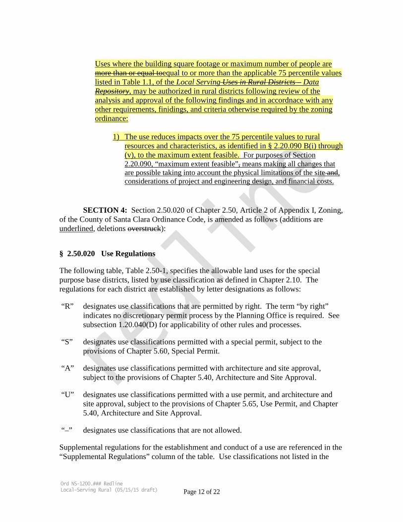
Uses where the building square footage or maximum number of people are more than or equal toequal to or more than the applicable 75 percentile values listed in Table 1.1, of the Local Serving Uses in Rural Districts – Data Repository, may be authorized in rural districts following review of the analysis and approval of the following findings and in accordnace with any other requirements, finidings, and criteria otherwise required by the zoning ordinance:
1) The use reduces impacts over the 75 percentile values to rural resources and characteristics, as identified in § 2.20.090 B(i) through (v), to the maximum extent feasible. For purposes of Section 2.20.090, “maximum extent feasible”, means making all changes that are possible taking into account the physical limitations of the site and, considerations of project and engineering design, and financial costs.
SECTION 4: Section 2.50.020 of Chapter 2.50, Article 2 of Appendix I, Zoning, of the County of Santa Clara Ordinance Code, is amended as follows (additions are underlined, deletions overstruck):
§ 2.50.020 Use Regulations
The following table, Table 2.50-1, specifies the allowable land uses for the special purpose base districts, listed by use classification as defined in Chapter 2.10. The regulations for each district are established by letter designations as follows:
“R” designates use classifications that are permitted by right. The term “by right” indicates no discretionary permit process by the Planning Office is required. See subsection 1.20.040(D) for applicability of other rules and processes.
“S” designates use classifications permitted with a special permit, subject to the provisions of Chapter 5.60, Special Permit.
“A” designates use classifications permitted with architecture and site approval, subject to the provisions of Chapter 5.40, Architecture and Site Approval.
“U” designates use classifications permitted with a use permit, and architecture and site approval, subject to the provisions of Chapter 5.65, Use Permit, and Chapter 5.40, Architecture and Site Approval.
“–” designates use classifications that are not allowed.
Supplemental regulations for the establishment and conduct of a use are referenced in the “Supplemental Regulations” column of the table. Use classifications not listed in the
Ord NS-1200.### Redline Local-Serving Rural (05/15/15 draft) Page 12 of 22
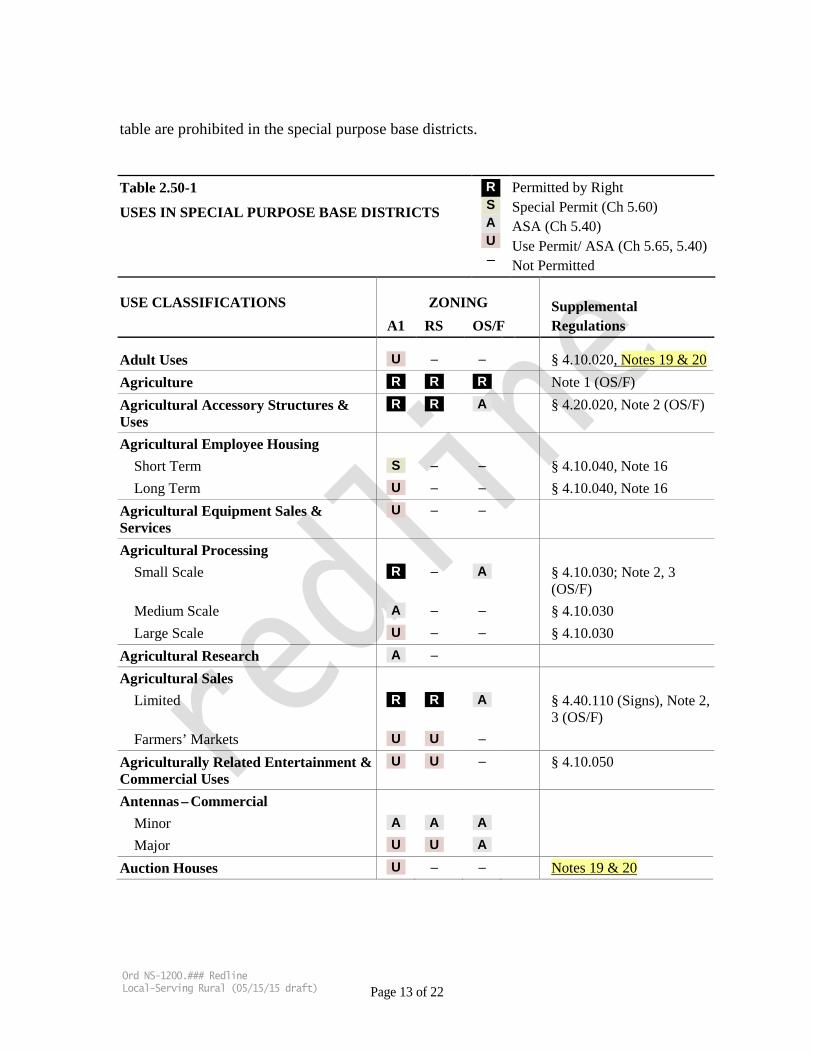
table are prohibited in the special purpose base districts. Table 2.50-1
USES IN SPECIAL PURPOSE BASE DISTRICTS
R S A U –
Permitted by Right Special Permit (Ch 5.60) ASA (Ch 5.40) Use Permit/ ASA (Ch 5.65, 5.40) Not Permitted
USE CLASSIFICATIONS ZONING Supplemental A1 RS OS/F Regulations
Adult Uses U – – § 4.10.020, Notes 19 & 20 Agriculture R R R Note 1 (OS/F) Agricultural Accessory Structures & Uses
R R A § 4.20.020, Note 2 (OS/F)
Agricultural Employee Housing Short Term S – – § 4.10.040, Note 16 Long Term U – – § 4.10.040, Note 16
Agricultural Equipment Sales & Services
U – –
Agricultural Processing Small Scale R – A § 4.10.030; Note 2, 3
(OS/F) Medium Scale A – – § 4.10.030 Large Scale U – – § 4.10.030
Agricultural Research A – Agricultural Sales
Limited R R A § 4.40.110 (Signs), Note 2, 3 (OS/F)
Farmers’ Markets U U – Agriculturally Related Entertainment & Commercial Uses
U U – § 4.10.050
Antennas – Commercial Minor A A A Major U U A
Auction Houses U – – Notes 19 & 20
Ord NS-1200.### Redline Local-Serving Rural (05/15/15 draft) Page 13 of 22
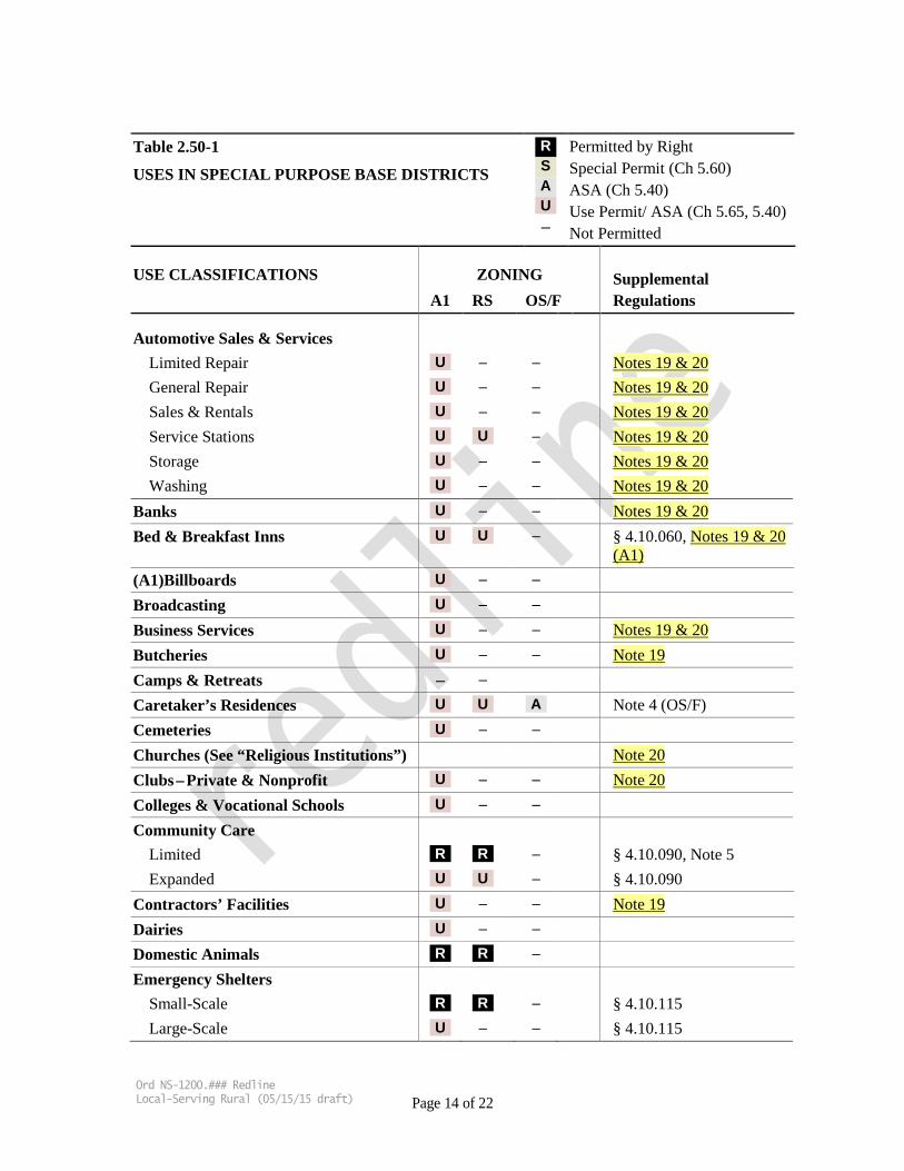
Table 2.50-1
USES IN SPECIAL PURPOSE BASE DISTRICTS
R S A U –
Permitted by Right Special Permit (Ch 5.60) ASA (Ch 5.40) Use Permit/ ASA (Ch 5.65, 5.40) Not Permitted
USE CLASSIFICATIONS ZONING Supplemental A1 RS OS/F Regulations
Automotive Sales & Services Limited Repair U – – Notes 19 & 20 General Repair U – – Notes 19 & 20 Sales & Rentals U – – Notes 19 & 20 Service Stations U U – Notes 19 & 20 Storage U – – Notes 19 & 20 Washing U – – Notes 19 & 20
Banks U – – Notes 19 & 20 Bed & Breakfast Inns U U – § 4.10.060, Notes 19 & 20
(A1) (A1)Billboards U – – Broadcasting U – – Business Services U – – Notes 19 & 20 Butcheries U – – Note 19 Camps & Retreats – – Caretaker’s Residences U U A Note 4 (OS/F) Cemeteries U – – Churches (See “Religious Institutions”) Note 20 Clubs – Private & Nonprofit U – – Note 20 Colleges & Vocational Schools U – – Community Care
Limited R R – § 4.10.090, Note 5 Expanded U U – § 4.10.090
Contractors’ Facilities U – – Note 19 Dairies U – – Domestic Animals R R – Emergency Shelters
Small-Scale R R – § 4.10.115 Large-Scale U – – § 4.10.115
Ord NS-1200.### Redline Local-Serving Rural (05/15/15 draft) Page 14 of 22
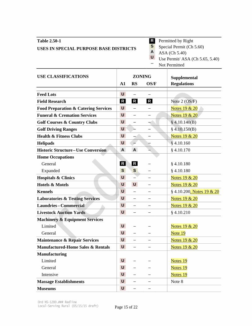
Table 2.50-1
USES IN SPECIAL PURPOSE BASE DISTRICTS
R S A U –
Permitted by Right Special Permit (Ch 5.60) ASA (Ch 5.40) Use Permit/ ASA (Ch 5.65, 5.40) Not Permitted
USE CLASSIFICATIONS ZONING Supplemental A1 RS OS/F Regulations
Feed Lots U – – Field Research R R R Note 2 (OS/F) Food Preparation & Catering Services U – – Notes 19 & 20 Funeral & Cremation Services U – – Notes 19 & 20 Golf Courses & Country Clubs U – – § 4.10.140(B) Golf Driving Ranges U – – § 4.10.150(B) Health & Fitness Clubs U – – Notes 19 & 20 Helipads U – – § 4.10.160 Historic Structure – Use Conversion A A – § 4.10.170 Home Occupations
General R R – § 4.10.180 Expanded S S – § 4.10.180
Hospitals & Clinics U – – Notes 19 & 20 Hotels & Motels U U – Notes 19 & 20 Kennels U – – § 4.10.200, Notes 19 & 20 Laboratories & Testing Services U – – Notes 19 & 20 Laundries – Commercial U – – Notes 19 & 20 Livestock Auction Yards U – – § 4.10.210 Machinery & Equipment Services
Limited U – – Notes 19 & 20 General U – – Note 19
Maintenance & Repair Services U – – Notes 19 & 20 Manufactured-Home Sales & Rentals U – – Notes 19 & 20 Manufacturing
Limited U – – Notes 19 General U – – Notes 19 Intensive U – – Notes 19
Massage Establishments U – – Note 8 Museums U – –
Ord NS-1200.### Redline Local-Serving Rural (05/15/15 draft) Page 15 of 22
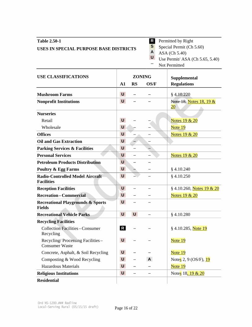
Table 2.50-1
USES IN SPECIAL PURPOSE BASE DISTRICTS
R S A U –
Permitted by Right Special Permit (Ch 5.60) ASA (Ch 5.40) Use Permit/ ASA (Ch 5.65, 5.40) Not Permitted
USE CLASSIFICATIONS ZONING Supplemental A1 RS OS/F Regulations
Mushroom Farms U – – § 4.10.220 Nonprofit Institutions U – – Note 18, Notes 18, 19 &
20 Nurseries
Retail U – – Notes 19 & 20 Wholesale U – – Note 19
Offices U – – Notes 19 & 20 Oil and Gas Extraction U – – Parking Services & Facilities U – – Personal Services U – – Notes 19 & 20 Petroleum Products Distribution U – – Poultry & Egg Farms U – – § 4.10.240 Radio-Controlled Model Aircraft Facilities
U – – § 4.10.250
Reception Facilities U – – § 4.10.260, Notes 19 & 20 Recreation – Commercial U – – Notes 19 & 20 Recreational Playgrounds & Sports Fields
U – –
Recreational Vehicle Parks U U – § 4.10.280 Recycling Facilities
Collection Facilities – Consumer Recycling
R – – § 4.10.285, Note 19
Recycling/ Processing Facilities –Consumer Waste
U – – Note 19
Concrete, Asphalt, & Soil Recycling U – – Note 19 Composting & Wood Recycling U – A Notes 2, 9 (OS/F), 19 Hazardous Materials U – – Note 19
Religious Institutions U – – Notes 18, 19 & 20 Residential
Ord NS-1200.### Redline Local-Serving Rural (05/15/15 draft) Page 16 of 22

Table 2.50-1
USES IN SPECIAL PURPOSE BASE DISTRICTS
R S A U –
Permitted by Right Special Permit (Ch 5.60) ASA (Ch 5.40) Use Permit/ ASA (Ch 5.65, 5.40) Not Permitted
USE CLASSIFICATIONS ZONING Supplemental A1 RS OS/F Regulations
Single-Family R R – Note 10 Two-Family U – – Multi-Family U – –
Residential Accessory Structures & Uses R R – § 4.20.020 Residential – Communal Institutional U – – Restaurants and Bars U U – Notes 19 & 20 (A1) Retail Sales & Services
General U U – Note 6 (RS), Notes 19 & 20 (A1)
Outdoor Sales & Storage U – – Note 19 Rodeos & Equestrian Events U – – Rooming Houses, Fraternities, &
Sororities U – –
Schools U – – Notes 19 & 20 Secondary Dwellings R R – § 4.10.340, Note 10 Solar Energy Conversion Systems – Commercial
Minor A – – § 4.10.345 Major U – – § 4.10.345
Sport Shooting U – – § 4.10.350 Stables – Commercial U – – § 4.10.360, Notes 19 & 20 Stanford – Specialized Facilities and Installations
– – A Note 11 (OS/F)
Studios – Arts & Crafts U – – Notes 19 & 20 Surface Mining U – – § 4.10.370 Swim & Tennis Clubs U – – Taxidermy U – – Notes 19 & 20 Temporary Residences / Construction R R – § 4.10.380 Theaters U – – Notes 19 & 20 Timber Harvest Operations – U – –
Ord NS-1200.### Redline Local-Serving Rural (05/15/15 draft) Page 17 of 22

Table 2.50-1
USES IN SPECIAL PURPOSE BASE DISTRICTS
R S A U –
Permitted by Right Special Permit (Ch 5.60) ASA (Ch 5.40) Use Permit/ ASA (Ch 5.65, 5.40) Not Permitted
USE CLASSIFICATIONS ZONING Supplemental A1 RS OS/F Regulations
Commercial Truck & Railroad Terminals U – – Truck Sales & Services
Repair U – – Note 19 Sales U – – Note 19 Storage U – – Note 19
Underground Mining U – – Utilities and Public Facilities Note 14
Minor A A A Note 12, 13 (OS/F) Major U U A Note 12, 13 (OS/F)
Veterinary Clinics & Hospitals U – – Notes 19 & 20 Warehousing & Storage
Indoor U – – Notes 19 & 20 Outdoor U – – Notes 19 & 20
Well-Drilling Operations U – – Wholesaling & Distribution U – – Notes 19 & 20 Wind Energy Conversion Systems –Commercial
U U – § 4.10.390
Wineries Small-Scale R R – § 4.10.395, § 4.40.110
(Signs) Medium-Scale S S – § 4.10.395, § 4.40.110 Large-Scale U U – § 4.10.395, § 4.40.110
Wireless Telecommunication Facilities Co-location A A A § 4.10.400, Note 15 Minor A A A § 4.10.400 Major U U A § 4.10.400
NOTES: 1. Within the OS/F district, tree farm operations that grow trees in containers or in the ground are
consistent with the “Agriculture” use classification.
Ord NS-1200.### Redline Local-Serving Rural (05/15/15 draft) Page 18 of 22
2. Within the OS/F district, structures ancillary to any allowed use or activity are permitted subject to the requirements of ASA (Chapter 5.40 and subsection 2.50.040(B)).
3. Within the OS/F district, agricultural processing is limited to low intensity processing and agricultural sales activities that would not significantly impact local transportation patterns. For example, activities such as packaging products for off-site shipping and allowing limited on-site purchase of agricultural commodities are consistent with allowable uses for this district. Activities such as a canning operation, or establishing a commercial outlet for sale of multiple agricultural commodities, would exceed the intensity allowed in this district. Prior to establishment of any use or activity, the Planning Office must determine that such use or activity is of low intensity and consistent with the General Use Permit requirements for the OS/F district.
4. Within the OS/F district, caretaker’s residences, as defined in § 2.10.030, are allowed as follows: A cumulative total of five caretaker’s residences is allowed to the extent they are consistent with all provisions of the Stanford General Use Permit and the zoning ordinance. This cumulative total includes all legal existing residential structures within the OS/F district, including any that may be legal nonconforming uses. Any existing legal nonconforming caretaker’s residences that existed on December 12, 2000 and have not been subsequently abandoned may continue to be utilized as caretaker residences. Stanford University bears the burden of establishing that any existing structure and use is legal or legal nonconforming. Consistent with all other provisions of the zoning ordinance, any legal structure that has been converted to a caretaker’s residence may be relocated, replaced, or modified, so long as there is no cumulative increase in the overall square footage of all residential structures. Caretaker’s residences are subject to ASA (Chapter 5.40 and subsection 2.50.040 (B)). Cumulative building area (square footage and building footprint) for the five caretaker’s residences shall not exceed the total square footage of documented building area for all legal or legal nonconforming residential structures that existed in the OS/F district on December 12, 2000.
5. Facilities qualifying as “Large-Family Day-Care Homes,” serving between 7 and 14 children, are subject to an administrative permit, per the provisions of Division B24 of the County Ordinance Code.
6. In Roadside Services (RS) districts, general retail sales uses must be limited in scale and ancillary to a permitted use that is primarily oriented toward serving the needs of the motoring public, consistent with the general plan.
7. The existing Stanford University Golf Course may be modified or reconfigured within its boundaries as they existed on December 12, 2000, but the Golf Course footprint may not be expanded. Modification or replacement of the golf course clubhouse or ancillary support facilities is permitted if consistent with all applicable provisions of the Community Plan, General Use Permit, and the zoning ordinance.
8. Massage establishments shall comply with the provisions of Division B22 of the County Ordinance Code.
9. Within the OS/F district, composting facilities are limited to those servicing Stanford University purposes, and no other communities, jurisdictions or uses (e.g., Stanford Shopping Center).
10. Single-family dwellings, including certain additions, and new secondary dwellings, may be subject to the building site approval provisions of Division C12-300-399 of the County Ordinance Code.
11. Within the OS/F district, Stanford specialized facilities and installations are limited to those structures or facilities that require a remote setting, including but not limited to facilities for astronomical or atmospheric research. Only those structures or facilities that require isolation from sources of interference (such as noise, vibration, electromagnetic fields, or similar impediments) are allowed.
Ord NS-1200.### Redline Local-Serving Rural (05/15/15 draft) Page 19 of 22

12. Within the OS/F district, existing utilities may be replaced if there is no increase in size or scale of aboveground structures. Above-ground disturbance resulting from the maintenance or replacement of such structures shall be restored to pre-disturbance condition.
13. Within the OS/F district, new utilities may be constructed that serve either Stanford or other lands if such facilities reasonably minimize degradation to the natural environment and maintain the predominantly natural appearance of the foothill setting.
14. Utility structures and facilities may be exempt from local zoning regulations if they are established by a government agency. There may also be federal or state laws that provide exemptions for certain types of utilities.
15. Co-location of wireless telecommunication facilities may be eligible for an ASA administrative review and approval (§ 5.40.050), where consistent with the provisions of this ordinance. Where the proposed co-location meets the criteria in Government Code § 65850.6(b) relating to previously approved facilities permitted by a means of a discretionary permit issued on or after January 1, 2007, and either a negative declaration, mitigated negative declaration, or environmental impact report was prepared and adopted, the co-location shall be reviewed for consistency with the approved plans, mitigation requirements, and conditions imposed on the existing facility, and if found consistent, will be subject only to a building permit or other applicable permits required by Title C of the County Ordinance Code.
16. Agricultural employee housing units may, on a limited basis, be used to accommodate overnight tourist stays. See subsection 4.10.395(C)(2) for criteria and permitting requirements.
17. Bed and breakfast inns ancillary to on-site wineries, agricultural sales operations or other agriculturally related uses shall be subject to a special permit, in lieu of a use permit, provided they are situated within the primary residence on the property.
18. Established Religious Institutions and Nonprofit Institutions may include Emergency Shelters: Small-Scale as an ancillary use by right.
19. Commercial and industrial uses in the San Martin Planning Area shall be subject to the applicable San Martin special area policies (R-LU 113 through R-LU 148) of the general plan.
20. Institutional uses in rural areas shall be subject to the local-serving criteria in Section 2.20.090. All commercial uses within San Martin’s Commercial and Industrial Use Permit Areas shall be subject to General Plan policy R-LU127 and Section 2.20.090.
SECTION 5: Section 4.10.310 of Chapter 4.10, Article 4 of Appendix I, Zoning, of the County of Santa Clara Ordinance Code, is amended to read as follows (additions are underlined, deletions overstruck):
§ 4.10.310 Retail Sales & Services: Local-Serving
This section refers to uses classified as Retail Sales & Services: Local-Serving as described in § 2.10.040. Such uses shall be subject to all of the following provisions:
A. Locally Oriented Local Serving. The use shall primarily serve the local community, and the location shall be accessible and convenient to the local population to be served. In rural districts, the term “local community” shall refer to rural, unincorporated residents of the area or community. Such such uses shall be sized and designed to be local serving, consistent with the rural character and
Ord NS-1200.### Redline Local-Serving Rural (05/15/15 draft) Page 20 of 22
the environment. The use shall be located to conveniently serve the local community.
In R1S and R3S districts applicable to Stanford University lands, “local community” shall refer to the campus residents, pursuant to the applicable provisions of Chapter 2, Land Use, of the 2000 Stanford University Community Plan. A business plan, demonstrating that the business will primarily serve the local community, shall be provided as a basis for review and approval of proposed uses. In R3 Multiple Family districts, “local community” shall refer primarily to the residents of the particular multi-family development.
B. Size. Maximum area of public-accessible floor space (measured from outer surfaces of enclosing walls, includes bathrooms) shall not exceed 1,200 square feet.
C. Demand. The number and capacity of other existing similar uses in the area, together with the proposed use, can be supported by the local community.
SECTION 6: Section 4.30.070 of Chapter 4.30, Article 4 of Appendix I, Zoning, of the County of Santa Clara Ordinance Code, is amended to read as follows (additions are underlined, deletions overstruck):
§ 4.30.070 Parking Design Standards
E. Surfacing. Parking spaces, driveways, and maneuvering areas shall be paved and permanently maintained with asphalt or cement. Such areas shall be provided with drainage facilities adequate to dispose of all surface water accumulated within the parking area. Bumper guards shall be provided when necessary to protect adjacent structures or properties. The approval body may modify the provisions of this subsection for surfacing located in the rural base districts. In rural areas, overflow parking for occasional special events shall be designed to be pervious.
SECTION 6: Severability. This ordinance and the various parts thereof are hereby declared to be severable. Should any section of this ordinance be declared by a court to be unconstitutional or invalid, such decision shall not affect the validity of the ordinance as a whole, or any portion thereof, other than the section so declared to be unconstitutional or invalid.
Ord NS-1200.### Redline Local-Serving Rural (05/15/15 draft) Page 21 of 22
PASSED AND ADOPTED by the Board of Supervisors of the County of Santa Clara, State of California on ___________________ by the following vote: AYES: NOES: ABSENT: ABSTAIN:
______________________________ Dave Cortese, President Board of Supervisors
ATTEST:
______________________________ Megan Doyle Clerk of the Board of Supervisors APPROVED AS TO FORM AND LEGALITY:
_________________________________ Elizabeth G. Pianca Deputy County Counsel
Ord NS-1200.### Redline Local-Serving Rural (05/15/15 draft) Page 22 of 22
Amended Exhibit C
Local Serving Data
Santa Clara County Department of Planning and Development
Local Serving Data
(Adopted by the Board of Supervisors: XXXX 2015)

Santa Clara County - Planning Office Local Serving Data
1. INTRODUCTION
This “Local Serving Data” document contains size, scale and intensity indicators for “local-serving” commercial or institutional uses in Santa Clara County’s (County) rural districts. There are currently no local serving industrial uses within the County, therefore there are no such indicators available for industrial uses. Drawn from historic commercial and institutional use permit approvals since 1980, these indicators provided in Appendix A include building size, traffic, maximum number of people – daily average and special events, and frequency of events. This document is intended to be adopted by the Board of Supervisors. The data within the document will be maintained and updated, from time-to-time, by the Department of Planning and Development based on future Use Permits approved by the County.
2. THRESHOLDS FOR A LOCAL-SERVING USE In order to determine the appropriate size, scale and intensity of proposed uses that are intended to be local serving, proposed development is to be benchmarked against existing locally serving land use indicators as specified in the County Zoning Ordinance Section 2.20.090. Table 1.1 and Table 1.1a provides the 75th percentile thresholds for local serving indicators, based on data points by zoning district. Since trip generation is a function of building square footage and use, this data has been excluded from the 75th percentile threshold table.
Table 1.1. Thresholds (75th Percentile) for Local-Serving Indicators
Maximum Number of People Building Square Footage
Commercial Uses 30 16,440 Rural Residential (RR) District
Institutional Uses
50 (daily) 6,510 220 (special events) Agricultural (A), Agricultural Ranchlands (AR) and Hillside (HS) Districts
Institutional Uses
70 (daily) 8,480 320 (special events)
Note: All values have been rounded to the closest 10.
Table 2.1a. Thresholds (75th Percentile) for Local-Serving Indicators Institutional Uses in All Rural Districts Combined
Maximum Number of People Building Square Footage
Institutional Uses
50 (daily average) 7,890 250 (special events) Note: All values have been rounded to the closest 10.
(Data Last Updated January 2014)

Santa Clara County - Planning Office Local Serving Data
To see the background data and the diagrams that depict the full range of data, please see Appendix A and Appendix B.
3. DATA COLLECTION METHODOLOGY The data sample includes commercial and institutional use permits (since adoption of the November 1980 General Plan up until December 2014) within Santa Clara County’s Agriculture (A), Agricultural Ranchlands (AR), Hillsides (HS) and Rural Residential (RR) base zoning districts, and commercial uses within the San Martin Commercial and Industrial Use Permit Areas (with the exception of uses on properties immediately adjacent to the San Martin Avenue/Highway 101 interchange that are east of Murphy Avenue). Within the rural districts, these local serving uses include the following land use classifications
1 Clubs – Private and Non-Profit 2 Hospitals and Clinics 3 Manufacturing: Small Scale Rural 4 Non-Profit Institutions 5 Religious Institutions 6 Retail Sales and Services – Local Serving 7 Schools 8 Commercial Uses (within the San Martin Commercial and Industrial Use Permit areas)
The step by step data collection methodology and the 75 percentile values determination process is provided below: Step 1: The data was initially filtered for all use permits in the rural zones approved between 1980 and
2014 using Geographic Information Systems (GIS) and the County’s databases. Uses approved prior to the 1980 General Plan were not considered because there were no “local-serving” policies at the time.
Step 2: The use permits were filtered based on whether or not a use classification was defined as a use within the eight (8) local serving uses as defined above. Uses that were approved in this time period by the County but never built were included in the analysis as they were considered to fall within the local serving criteria.
Step 3: Planning staff reviewed each of the files to identify maximum number of people, traffic, and building size data.
Step 4: When staff was unable to find data and/or files for certain projects they were either removed from consideration, or if partial information was available, data was extrapolated for number of people and average daily trips.
Step 5: The following describes the data extrapolation methodology: 1. People: In instances where number of users was not clearly described in a Use Permit,
maximum number of people was extrapolated from existing parking spaces (one user per parking space) determined by a review of aerial site photographs or the use permit conditions of approval. If only one number was provided for users, this was counted as maximum number of people allowed at events.
(Data Last Updated January 2014)

Santa Clara County - Planning Office Local Serving Data
2. Trips: For average daily trips extrapolation, the current Trip Generation Manual1 was used to determine the trips based on use and building square footage.
Step 6: If a use permit had multiple iterations, the largest approved building size and number of people were used.
Step 7: Once the data set was complete, the 75 percentile values were calculated for building square feet, maximum number of people, and average daily trips. These values were rounded off to facilitate ease of implementation.
The County has no records for certain local-serving land use classifications, such as Hospitals/Clinics and Schools, ever being approved since the adoption of the1980 General Plan. However, these uses are a permitted use subject to any other requirements, findings, and criteria otherwise required by the zoning ordinance. The datasets in Appendix A, diagrams in Appendix B, and thresholds in Table 1.1 will be updated periodically as future use permits are approved to maintain a current dataset.
1 Institute of Transportation Engineers, Trip General Manual 9th Edition, Volume 2 and 3 Data
(Data Last Updated January 2014)

Santa Clara County - Planning Office Local Serving Data Repository
Appendix A
Table A.1. Institutional Uses – Dataset for Local Serving Indicators
S. NO.
BASE ZONE
File Number DATE Site Address
Property Size
(acres)
Building Square Footage
Max Number
of People (Daily)
Max Number
of People
(Events)
Event Frequency per year
Average Daily Trips
(ADT) - Workday
Max. (Weekend
/Event) Daily Trips Name
1 A 2714-91P 1991 15055 Monterey Highway 5.5 6,576 32 60 52 60 – ITE Manual
Morgan Hill Bible Church
2 A 5121-91P 1991
West side of Santa Teresa Boulevard (south corner of
De Bruin Way) 5.7 9,077 42 247 104 84 432 Cornerstone Church of the
Nazarene
3 HS 2020-83P 1983 23185 Summit Road 8 7,888 96 384
72 – ITE Manual
Church of Latter Day Saints
4 RR 241-00P 2000 12415 Murphy Avenue 5.92 6,990 22 250
204 – ITE Manual
San Martin Lion's Club
5 RR 9013-05P 2005 1300 Church Avenue 4.6 5,086 50 100 6 30 80 Vo Vu Zen Center (Buddhist
Meditation Association)
6 RR 2899-86P 1986 10468 Crothers Road 10.54 1,890 12 48
10 -ITE Manual
Persian Zoroastrian Organization (Trustees of
the Rustam)
7 RR 3554-88P 1988 13485 Colony Avenue 1.88 4,472 35 122
41 – ITE Manual
South County Church of Christ
8 RR 6992-00P 2000 20431 McKean Road 10 10000 105 500
170 670 Chinese Church in Christ
South Valley
9 RR 5056 2013
West side of Monterey Road (between Church and
Masten Avenues) 12.7 1,147 10 N/A N/A 9-ITE
Manual Vaidica Vidhya Ganapathi
Center Inc.
(Data Last Updated January 2014)
Santa Clara County - Planning Office Local Serving Data Repository
Appendix A Table A.2. Commercial Uses – Dataset for Local Serving Indicators
S. NO.
BASE ZONE
File Number DATE Site Address
Building Square Footage
Max Number
of People (Daily)
Property Size (acres)
Average Daily Trips
(ADT) - Workday
Max. (Weekend
/Event) Daily Trips Name Description
1 A 2706-11P 2011 8145 Monterey
Highway 783 12 0.22 3 – ITE Manual
Joe's Gas, Bait, & Tackle
Shop Bait Shop
2 A1 2228-00P 2000
Northeast Corner of Monterey Road and Crowner Road 4,774 40 0.35 86 432 Calderon Tire Shop
3 A1 3335-87P 1987 13755 Llagas
Avenue 24,440 46 13.5 80 Wholesale/Retail Building
Supplies
4 A1 470-92P 1992 12955 Monterey
Road 12,877 28 2.28 61 – ITE Manual
Veterinary Hospital and Commercial Office
5 A1 7615-00P 2000 13240 Llagas
Avenue 10,075 15 2.14 5
Bottled Water Distribution
Facility
6 A1 9413-14P 2014 13920 Llagas
Avenue 20,000 27 4.21 325 Freedom
Paws Dog Training Facility and
Day/Night Boarding
7 HS 5623-94P 1994 4275 Gilroy Hot
Springs Road 1,000 16 1.18 5 100
Grocery Store, Convenience Store, Bait
Shop
(Data Last Updated January 2014)
Santa Clara County - Planning Office Local Serving Data Repository
Appendix B
Figure A.1 Institutional Uses – Square Footage and Maximum Number of People
0
2,000
4,000
6,000
8,000
10,000
12,000
0 20 40 60 80 100 120
Sq F
t
Maximum # of People (Daily)
Uses in A and HS Zones Uses in RR Zones Sq Ft 75 percentile Max # of People (Daily) 75 Percentile
(Data Last Updated January 2014)

Santa Clara County - Planning Office Local Serving Data Repository
Appendix B Figure A.2 Institutional Uses –Maximum Number of People (Events)
0
100
200
300
400
500
600
0 1000 2000 3000 4000 5000 6000 7000 8000 9000 10000
Max
imum
# o
f Peo
ple
(Eve
nts)
File Number
Use Permit Occupancy (1981-2014)
Uses in A and HS Zones Uses in RR Zones ALL 75 percentile
(Data Last Updated January 2014)
Santa Clara County - Planning Office Local Serving Data Repository
Appendix B Figure A.3 Commercial Uses – Square Footage and Maximum Number of People
0.00
5000.00
10000.00
15000.00
20000.00
25000.00
30000.00
0 5 10 15 20 25 30 35 40 45 50
Sq F
t
Max # of People
Use Permit Sq. Ft. (1981-2014)
All Commercial Uses Sq Ft 75 Percentile Max # of People 75 Percentile
(Data Last Updated January 2014)

Exhibit D
May Meetings - Notes and Minutes
San Martin Planning Advisory Committee Meeting Staff ‘s Meeting Notes – May 27, 2015
SAN MARTIN PLANNING ADVISORY COMMITTEE Staff’s Meeting Notes
Date: Wednesday, May 27, 2015
Location: South County Office
Staff Attendees:
Colleen Tsuchimoto (SCC Planner III) Manira Sandhir, AICP (SCC Planner II) Rob Eastwood (SCC Interim Planning Manager) Roland Velasco (District 1 Land Use Aide)
Review of proposed amendments to the Santa Clara County General Plan and Zoning Ordinance addressing local serving policy provisions for the rural unincorporated areas of the County and a proposed set of guidelines “Size, Scale and Intensity Guidelines: Industrial, Commercial, and Institutional Uses in Rural Areas.”
Staff provided a presentation. Presenters were Rob Eastwood, Colleen Tsuchimoto, and Manira Sandhir.
SMPAC Commissioners Comments and Discussion:
1. Why was the threshold changed to 75% for further analysis? Staff explained that the Planning Commissioner’s input asked for a higher threshold for requiring more analysis.
2. SMPAC was concerned that there was not enough time to review the staff report. A 10 day review time ahead of the meeting was previously promised. Rob responded that more time was needed to finalize the information, and reports are normally distributed 1 week prior to the Planning Commission hearing. Staff shall follow-up to find out why the staff report packets were not mailed directly to the SMPAC commissioners.
3. SMPAC agrees with public input that more time is needed to review the proposal, and data.
Public comments and input:
1. The data is skewed because all the rural districts data are lumped together in 1 category. Rural residential is the essence of San Martin, different from the Hillsides and other rural districts. Data is also inaccurate as certain values are missing for maximum number of people and trips. Staff responded that the data will be updated for the Planning Commission hearing to provide 75% threshold of Rural Residential, and 75% threshold of the other rural districts.
2. Small amount of data leads to erroneous information. Staff should investigate all their files further to show all the San Martin facilities in the dataset.
Page 1 of 2
San Martin Planning Advisory Committee Meeting Staff ‘s Meeting Notes – May 27, 2015
Staff responded that only those projects which were approved 1981 to present time are in the dataset consistent with the current County General Plan.
3. How are events defined? How many events? What oversight does the County have to address noise impacts of events? Staff responded that events are not meant to be an ongoing year round. There are few special events during the year which accommodate for more people onsite for special occasions – festivals etc. Noise is always in accordance with the County Noise Ordinance.
4. As the facilities expand uses, how are the projects evaluated? Any expansions will be evaluated according to the proposed standards subject to Board adoption.
5. The language proposed is too vague. Local-serving means providing services to the locals, and changing policy to meet practice is not appropriate. Currently there are no standards to measure local serving, and existing policy is not consistent with federal laws. Therefore, modifications are being proposed that still maintain intent of the General Plan while also establishing measurable criteria.
6. A member of the public also expressed concerns about cemeteries. Cemeteries would not be affected by this project.
Page 2 of 2

County of Santa Clara Planning Commission and Board of Zoning Adjustment
DRAFT MINUTES
May 28, 2015
8. File 10571-14CP Owner/Applicant: County of Santa Clara
Project Planners: Colleen Tsuchimoto (408) 299-5797, [email protected] and Manira Sandhir (408) 299-5787, [email protected]
Property Location: County-wide; Zoning: RR, A, A1, HS, AR; General Plan: Rural Residential, Agriculture, Hillsides, Agricultural Ranchlands. Public hearing to consider amendments to the Santa Clara County General Plan and Zoning Ordinance addressing local serving policy provisions for the rural unincorporated areas of the County and proposed set of guidelines - “Guidelines for Local Serving Industrial, Commercial, and Institutional Uses in Rural Areas.”
Possible Actions:
a) Forward favorable/unfavorable recommendation to the Board of Supervisors to accept Addendum to the 1994 General Plan Program Environmental Impact Report.
b) Forward favorable/unfavorable recommendation to the Board of Supervisors to adopt proposed amendments to the County General Plan and Zoning Ordinance for local serving policy provisions.
c) Forward favorable/unfavorable recommendation to the Board of Supervisors regarding guidelines for local serving policy provisions.
8. File 10571-14CP Owner/Applicant: County of Santa Clara
Project Planners: Colleen Tsuchimoto (408) 299-5797, [email protected] and Manira Sandhir (408) 299-5787, [email protected]
Property Location: County-wide; Zoning: RR, A, A1, HS, AR; General Plan: Rural Residential, Agriculture, Hillsides, Agricultural Ranchlands.
On behalf of staff, Rob Eastwood, Planning Manager, requested a five minute break to allow staff additional time to process and incorporate comments from the May 27, 2015 San Martin Planning Advisory Committee (SMPAC).
The Commission took a break at 1:30 p.m.
The meeting resumed at 1:44 p.m. During the break, supplemental packet information was distributed to the Commission by staff dated May 28, 2015, Agenda Item #8, - Local-Serving Policy Provision, Supplemental Packet – Revised Zoning Ordinance Section 2.20.090 and 75th Percentile Values.
COUNTY OF SANTA CLARA PLANNING COMMISSION AND BOARD OF ZONING ADJUSTMENT
DRAFT MINUTES Item Number 8
MAY 28, 2015
Associate Planner Colleen Tsuchimoto introduced the item and Associate Planner Manira Sandhir narrated a PowerPoint presentation, Local-Serving Uses in Rural Districts: General Plan and Zoning Updates, Planning Commission, May 28, 2015. On behalf of the SMPAC meeting on May 28, 2015, Commissioner Rauser reported that Committee members expressed concern that 1) the 10-day commitment from staff to the community was not met; 2) both terms “local-serving” and “standards” needed clear understanding of the definition; 3) noise levels needed to be defined; 4) special events need to be specific in detail; and, 5) there continued to be ongoing concern for cemeteries and water quality issues. He noted the importance for staff and applicants to understand what the changes are and how to enforce those changes. Chairperson Schmidt opened the public input portion of the hearing. Michael Brookman, San Martin Neighborhood Alliance, spoke in support of the amendments. He expressed concern that the quality of data was not accurate and he stated that the proposed amendments would help to maintain and preserve the rural atmosphere. Dhruv Khanna, concerned business owner, spoke in opposition of staff recommendation. He commented on the rural residential definition, scale, and intensity, and commented that all local-serving uses should be eliminated from the statute. John Sanders, concerned South County resident, spoke to the maximum number of people per event and recommended that the number should be 180 based on the 75th percentile rather than 250 people. Next, he requested the Commission continue the project for 30 days to provide the public the opportunity to review new documentation. Trina Hineser, San Martin Neighborhood Alliance, spoke in support of a 30-day continuance to allow additional public review of new documentation. Connie Ludewig, resident of San Martin, noted that the term local-serving was in need of further definition. She expressed support for a 30-day extension to provide additional time for public review. She spoke to water issues and noise issues for special events especially amplified noise which she requested be limited to the hours of 10 a.m. to 10 p.m. Ed Sattler, resident of San Martin, supported a 30-day continuance to allow additional public review of new documentation. He expressed concern that the 10-days commitment from staff to the community was not met. Hearing no one else, Chairperson Schmidt closed the public hearing. Commissioner Rauser inquired at what point is minimization measure feasible and encouraged the commission to continue the project for 30 days. Commissioner Cauble spoke to the frequency for updating data, preserving the rural urban distinction, and utilizing the web for transparency of the policy and ease of identifying the current documents. She noted she continued to have concern using “local-serving” and suggested the addition of a general category “C” in the General Plan which would be for uses preempted by the Federal Government.
Commissioner Lefaver concurred with fellow commissioners and suggested making a distinction between the General Plan and Zoning Ordinance language. Commissioner Ruiz expressed concern for “local-serving” language and that its intent could be misinterpreted. Chairperson Schmidt recommended removing “equal to” in either A or B of the proposed Zoning Ordinance changes and clarify restaurant square footage to either just the restaurant or the whole facility. On motion of Commissioner Rauser, seconded by Commissioner Lefaver, the Commission voted favorably to continue the item to the next meeting of the Commission on June 25, 2015. The vote was as follows: AYES: Cauble, Lefaver, Moore, Rauser, Resendez, Ruiz, and Schmidt