Embed Size (px)
Citation preview

MEMO
DATE: April 6, 2015
TO: Planning and Sustainability Commission
FROM: Deborah Stein, Principal Planner; Marty Stockton, Southeast District Liaison
CC: Susan Anderson, Director; Joe Zehnder, Chief Planner; Eric Engstrom, Principal Planner
SUBJECT: Residential Densities: Up-Designations, April 14, 2015 Work Session
Introduction This is the second report for the Planning and Sustainability Commission on Residential Densities. This report is intended to inform your work session on April 14, 2015. The first Residential Densities report (February 25, 2015) focused on proposed down-designations, which you discussed on March 10 and March 24. This report covers proposed Comprehensive Plan Map up-designations in Inner Southeast Portland – places where a higher residential density designation is proposed than what is on the map today. Staff-recommended changes to address related testimony are also covered in this report. As with your earlier deliberations about residential densities on the Comprehensive Plan map, we suggest that you consider this broad question:
What is the appropriate residential designation, given the existing land use patterns and density, historical development patterns, housing affordability, historic and cultural resources: streetscape and architecture, proximity to centers and corridors, and other factors?
This report summarizes factors and data that staff considered to develop the July 2014 proposal, and outlines staff’s approach to refine the July proposal based on testimony received during the public comment period (July 2014 through March 2015) and further analysis.
The purpose of this memo is to inform your recommendations about: • Residential up-designations (e.g., as proposed in Buckman, Creston-Kenilworth, Richmond, Mt.
Tabor and Sunnyside), which would remedy existing nonconforming residential densities.

2
• Residential up-designations requested in testimony, which may also remedy existing nonconforming residential densities.
Context
The January 2015 Centers and Corridors staff report recommended changes to the Urban Design Framework and corresponding policies to address the inner-most neighborhoods surrounding the Central City. A working title for this area is the “Inner Ring Districts.” The intent is to provide policies for the Inner Ring Districts that acknowledge the substantial differences between these areas and other locations identified as centers and corridors. These districts often share a history of developing with an eclectic mix of structures in the late nineteenth century, before expansion of the streetcar lines (Eliot, Northwest, Irvington, Kerns, Buckman, South Portland, Goose Hollow).The Inner Ring District policies also address testimony that these areas are playing more significant roles in accommodating growth than suggested by the original UDF center designations. Several factors influence proposed Inner Ring policies, and relate to issues discussed in this report:
• Inner Ring Districts are high opportunity areas (per proposed housing policy). • Growth in these areas supports reduced vehicle miles travelled (VMT) due to proximity to
Central City and to local services (well-served by frequent transit, commercial services within ¼-mile walk for most people, 3-mile easy biking distance of Central City).
• Diversity of existing housing – historic homes and apartment buildings intermixed. • High concentration of historic resources and districts (Lair Hill, Alphabet, Irvington, Ladd’s
Addition, etc.). • History of demolition in post-war era (freeway development, urban renewal, surface parking
lots interrupted or created gaps in the historic urban form and street grid). Overview of proposed changes In general, the proposed residential densities addressed in this report would match (or come closer to matching) the housing capacity of current residential buildings, rather than introduce new residential capacity beyond what’s in place today. In other words, these proposals would “true up” the map designations with what is now on the ground. These changes are proposed primarily to remedy nonconforming residential density situations that now exist, which can present obstacles for property maintenance and improvement and can lead to disinvestment. (See the March 16, 2015 memo, Nonconforming Residential Densities and Uses, for more information.) Nonconforming residential densities occur in numerous locations in Inner Southeast Portland. For example, Buckman is a neighborhood where there are a number of duplexes, triplexes and apartment complexes scattered among single-dwelling structures on varying lots sizes. A decision was made in the

3
1980s to apply R5 zoning broadly to this neighborhood in order to preserve and stabilize the remaining single-dwelling structures and residential character of the historic neighborhood. Staff focused on Inner Southeast Portland as a starting point for adjusting residential densities through the Comprehensive Plan update because this is where the largest disconnect exists between what is built and what zones allow. Unlike Inner Southeast Portland, other quadrants of the city have undergone community planning processes in which Comprehensive Plan and zoning maps have been updated since 1980. The East Portland Community Plan (encompassing the inner neighborhoods extending from the Willamette River east to roughly SE 60th) was initiated in 1996, but was halted a year later because of budget cuts following passage of Ballot Measure 47, a property tax limitation. Therefore, Inner Southeast Portland continues to have many pockets where the Comprehensive Plan and zoning designations don’t match, and where map designations don’t reflect built densities. Residential housing capacity As noted in the February 25, 2015 staff report, Residential Densities, the proposed Comprehensive Plan Map was based on a 30-50-20 residential growth strategy; that is, 30 percent of the anticipated household growth allocated to the Central City, 50 percent to other Centers and Corridors, and 20 percent to residential neighborhoods outside of the Centers and Corridors. Of the total forecast growth citywide (2015-35), approximately:
• 1.5 percent is expected to occur in Farm/Forest, R20 and R10 combined. • 6 percent in R7 and R5. • 12 percent in R3 and R2.5. • 20 percent in multi-dwelling zones of R2 and above.
The vacant and underutilized land within these residentially designated areas have a combined development capacity that is double the expected growth, after considering constraints. This means that it is possible to be more selective about where development occurs in residential zones. That said, there are some designations where the supply of vacant and underutilized land is tight relative to expected demand. This is particularly true in the R5 designation, where the amount of vacant and underutilized land is only slightly above expected needs. The allowed mix of housing in the residential zones has also been examined relative to expected incomes. In general, the diversity of the housing type production should be sufficient to produce enough housing units to meet the future demand across a variety of income levels, except for the low income groups, which will have fewer choices from new development. A similar dynamic exists at the single-family level, where (based on expected incomes) the demand for compact small-lot or high-density single family homes is expected to exceed supply. These more affordable single-dwelling configurations are allowed primarily in the R2, R2.5 and R5 zones. Some households seeking affordable home ownership opportunities will have to consider multifamily housing types (condos) or look to suburban locations because Portland’s single-family supply is limited and skewed toward larger more expensive lots.

4
Why weren’t additional up-designations considered? There are additional locations in the city where selective up-designations would expand opportunities for new housing, where owners and renters could take advantage of proximity to the Central City and/or centers or corridors and the availability of transit, services, and amenities. Rather than address these opportunities through the citywide Comprehensive Plan update process, staff recommends that residential densities are considered through area-specific planning projects with localized and inclusive community engagement. Through these projects, we should also consider the potential for tenant displacement as a result of up-designations and/or up-zonings, and apply approaches to ensure that permanently affordable housing is available to low- and moderate-income Portlanders. Proposed map changes The July 2014 draft map proposed changes in portions of several Inner Southeast neighborhoods where the existing platting pattern and nonconforming residential densities and uses are predominantly at a higher density than the current Comprehensive Plan designation would allow.
� R5�R2.5: This group of proposed changes includes areas that are designated R5 in the current Comprehensive Plan, but are predominantly platted with lot sizes less than 3,000 square feet or developed with duplexes and multi-dwelling housing. This group includes portions of Buckman, Mt. Tabor, Richmond, and Sunnyside.
� R5 or R2.5�R2 or R1: This group includes areas that are designated R5 or R2.5 in the current
Comprehensive Plan, but are predominantly developed with duplexes, attached housing or multi-dwelling housing. This group includes portions of Buckman, Creston-Kenilworth, Richmond, and Sunnyside.
� Split-zoned sites: Staff has also proposed map changes on scattered split-zoned sites where the
property is developed with multi-dwelling housing and/or the higher designation is applied to over 50% of the site.
Methodology To develop the July 2014 proposal for residential up-designations, and in follow-up analysis, staff considered and inventoried:
• Lot sizes less than 3,000 square feet in areas designated for R5. • Existing development on each tax lot to identify single units, duplexes, and multi-family units
ranging from three to five units, six to ten units and ten-plus units. • Properties designated as Historic Landmarks or on the Historic Resources Inventory.

5
• Properties owned by non-profit affordable housing providers, including Catholic Charities, Home Forward (formerly the Housing Authority of Portland), Portland Community Reinvestment Initiatives, Inc. (PCRI), and REACH Community Development.
Staff also conducted an analysis of areas that are zoned R5 and R2.5 with nonconforming densities and uses and are located within ¼ mile of a designated center or corridor. There are many more nonconforming residential density situations in Southeast Portland (and elsewhere) than are proposed to be addressed through the Comprehensive Plan update at this time. Staff hopes that this general approach to matching (or coming closer to matching) existing development with Comprehensive Plan designations can be applied through area-specific planning projects in the future. Policy support R2.5, R2 and R1 residential densities are consistent with policies that expand the range of housing opportunities in inner ring districts, which are part of the Inner Neighborhoods Pattern Area. Staff considered the appropriate density for properties owned and managed by non-profit affordable housing providers within the areas studied, where current nonconforming residential densities pose obstacles to renovation and maintenance of such properties. Additionally, policies regarding inner neighborhoods support infill on vacant and underutilized sites, and re-use of historic buildings on adopted inventories. Housing should be located where there is good access to opportunities, including active transportation, jobs, open space, high-quality schools, and supportive services and amenities. Comprehensive Plan policies encourage development and maintenance of housing, especially multi-dwelling housing, that protects the health and safety of residents. Summary of testimony Buckman - SE 17th and SE 19th between SE Stark and SE Alder Streets: While the Buckman Community Association Board did not vote on the up-designation of the area between SE 17th and 19th from R5 to R2.5, they heard from neighbors quite concerned about this proposal. Susan Lindsay, Co-Chair, Buckman Community Association, shared the following history in her testimony:
The R5 designation was hard fought in the years of massive demolitions and open turn of the century house burnings allowed in the area for the development of track apartments in the 1960’s and 70’s. Maintaining options for families, for home ownership in a neighborhood with over 80% rentals is critical to supporting the schools, the parks and stabilizing the community. While much of residential Buckman is already zoned R2.5, R1 or contains apartments built in the

6
CS zones, the interior areas away from the main streets have been kept at R5 to help maintain and protect the housing stock. Yet, by some intense focus and scrutiny, this area is now all blocked out to be upzoned. We ask for a relook at Planning staff’s move to rezone this area, for further understanding of the historical and cultural reasons for the needed R5 in this area, and for it to be left as it is for now.
One owner with a property on the historic resource inventory within this proposal felt concerned that the R5 to R2.5 map change could allow for subdivision of the corner lot*, doing so would destroy the historic relationship of the house to its garage. Other points made were concern about retaining block character and that there are other half-blocks in the neighborhood, which are built to the R2.5 density, keeping their R5 zoning. Several testifiers, in support, referenced this testimony. *Note that per PZC Section 33.110.240.E duplexes and attached houses are allowed on corner lots in the R20 through R2.5 zones, which includes the current R5 zone. Another property owner just outside of the proposal conversely requested that her historic resource inventory property be included in the R2.5 change to allow for more units, which she asserted would assist in preserving the structure. Hand-drawn maps were included: one of the existing zoning and the other of the actual use (number of units) and what the zoning could be. Stating that in her analysis, that the majority of properties (80%) have existing buildings with more density than R5. At least half are officially zoned as R2.5, the others aren’t zoned that but are de facto used as R2.5 or denser. Buckman- SE Ankeny and SE Ash, on SE 22nd, SE 24th and SE 26th: Several testifiers, both property owners and individuals, commented on the nonconforming residential properties in this area, that have existing long-term uses that exceed the development density of their respective existing zones. Testifiers expressed support for bringing these properties into conformance because the buildings mesh well into the neighborhood and that they are located one- to two-blocks from E. Burnside. Buckman/Sunnyside: SE 26th and SE 30th between SE Stark and SE Belmont Streets: The Buckman Community Association did not submit testimony on this map change. The Sunnyside Neighborhood Association was briefed on and discussed the proposal but did not submit testimony on the map change. Several property owners of apartment buildings in this area submitted testimony requesting modification to the proposed R2 zoning with a further up-designation to R1 (or even RH).
The current proposal in the Comprehensive Plan is to change the designation from an R2.5 Attached Single-Dwelling zone to an R2 Multi-Dwelling zone. Our 18-unit apartment complex is also currently classified a legal non-conforming density and will remain classified as a legal non-conforming density under the proposed Comprehensive Plan.
Given this classification, we would be able to rebuild our 18-unit apartment complex in the event it was burnt down or destroyed by some act of god. In addition, our 18-unit apartment complex

7
would then have to be rebuilt within a five year time frame. However, if we were to demolish our apartment complex intentionally and redevelop the site due to economic reasons, we would be required to redevelop the site based on the current zoning of our property. As a result, this would prevent us from replacing the old 18-unit complex with a new 18-unit apartment complex, but would only allow us to build a 7-unit apartment complex under the current zoning for our property (R2.5) or a 9-unit apartment complex under the proposed R2 zoning in the Comprehensive Plan.
Another point of view:
I would like to make enhancements to my property and someday expand the cottage in back of the 4-plex to be a few more units. If I was R1, I could possibly increase up to 50% more units by adding amenities. We take great care of our properties and currently offer storage for bikes, laundry facilities, but could also add an ADA accessible unit or amenities you might suggest to increase our density. We would also like to consider seeing what would be required to get a charging station out front for electric cars, etc. We want to be progressive with the city and offer inner-city housing, but right now our hands are tied.
Creston-Kenilworth – SE31st and SE 32nd between SE Powell and SE Francis: Proposed map change is from R2.5 to R2 for this multi-dwelling development. Testimony suggests that this area should be changed to R1 as it is near Powell Blvd and adjacent to R1 parcels also developed with apartments. Richmond - SE Cesar E. Chavez Blvd: Individual testimony for 3332-3344 SE Cesar E Chavez Blvd, requested a map change from R2.5 to R1 on a split-designated site. The western third of this parcel is zoned R1. The eastern two thirds, developed with apartments, is zoned R2.5. Sunnyside - East of SE Peacock Lane to SE 42nd, north of SE Belmont Street to SE Stark Street: Both the Sunnyside Neighborhood Association and individuals submitted testimony on this area along the north side of SE Belmont Street and the large multi-dwelling development just north of the corridor. This area, just east of Peacock Lane and extending from SE Belmont to SE Stark, is developed with lower-density apartment complexes. It covers 6 square blocks, and is near the Belmont and Chavez intersection. Testimony requested for this entire 6-block section to be re-designated R1 and re-zoned R1. Doing so would increase the potential residential capacity in a well-served area of Southeast Portland. Sunnyside NA requested that the lots fronting SE Belmont be designated to Mixed Use. Sunnyside - SE Cesar E. Chavez Blvd: Individual testimony on a recently renovated apartment building, which is called the June Manor condominiums, at 3866 SE Taylor Street, requested a map change from R2.5 to R1.

8
� Discussion questions:
1. Does the PSC generally support this approach to up-designate to acknowledge existing residential development and avoid nonconforming residential density situations?
a. Supporting property owners, including affordable housing providers, in maintaining and/or replacing multi-dwelling density and use over time.
b. Supporting density in high opportunity areas.
2. Does the PSC support maintaining a level of affordability in the Inner Ring Districts by acknowledging multi-dwelling development currently in single-dwelling zones?
a. Supporting a variety of densities and uses, rather than replacement of multi-dwelling with single-dwelling uses.
b. Supporting affordable housing providers.
3. What other tools should be considered to strengthen preservation of historic structures? Staff recommends that a future legislative project design, pilot, and refine a new efficient approach to update the City’s Historic Resource Inventory. Note BPS’s 2015-16 Requested Budget includes a one-time funding request for a Historic Resource Inventory update and this project may assist in addressing public’s concerns about historic preservation.
4. Does the PSC support the following amendments to the July 2014 proposal? In response to
testimony and further evaluation, staff recommends amendments as outlined in the table that follows.
5. Does the PSC support later refinement plans to more systematically address other similar situations in Inner Southeast and elsewhere?

Resi
dent
ial D
ensi
ties:
Up-
Desi
gnat
ions
Pr
opos
ed A
men
dmen
ts to
the
July
201
4 Pr
opos
al
Plan
ning
and
Sus
tain
abili
ty C
omm
issio
n W
ork
Sess
ion
- Apr
il 14
, 201
5
Map
A sh
ows l
ocat
ions
of a
men
dmen
t pro
posa
ls. M
aps B
-E sh
ow d
etai
ls of
staf
f’s re
com
men
datio
ns. N
ote
that
reco
mm
ende
d de
sign
atio
ns a
re re
pres
ente
d in
col
or, w
hile
cur
rent
des
igna
tions
are
not
ed in
bla
ck a
nd w
hite
.
No.
Ju
ly 2
015
Prop
osal
Lo
catio
n Te
stim
ony
Reco
mm
enda
tions
Ra
tiona
le
1 R5
�R2
.5
and
R1
SE S
tark
to S
E Al
der,
betw
een
SE 1
6th a
nd S
E 19
th (B
uckm
an)
- Rem
ove
prop
osal
, ret
ain
R5 d
esig
natio
n.
(indi
vidu
als,
pro
pert
y ow
ner)
- A
pply
R2
or R
2.5
desig
natio
n to
add
ition
al
HRI p
rope
rty
not i
nclu
ded
in th
e pr
opos
al (p
rope
rty
owne
r)
1.
Expa
nd R
2.5
to in
clud
e th
e fu
ll bl
ocks
bet
wee
n SE
Sta
rk a
nd S
E W
ashi
ngto
n fr
om 1
6th to
SE
18th
an
d to
four
par
cels
alon
g th
e w
est s
ide
of S
E 16
th b
etw
een
SE
Star
k an
d SE
Was
hing
ton.
2.
Ap
ply
R1 o
n th
e ea
st si
de o
f SE
19th
Ave
nue
betw
een
SE S
tark
an
d SE
Was
hing
ton.
�
See
Map
B
Ackn
owle
dge
exist
ing
resid
entia
l dev
elop
men
t an
d av
oid
nonc
onfo
rmin
g sit
uatio
ns. W
ith
revi
sed
prop
osal
, 80%
of n
onco
nfor
min
g pr
oper
ties w
ould
bec
ome
conf
orm
ing.
Ano
ther
20
% o
f the
mul
ti-dw
ellin
g ho
usin
g w
ould
be
clos
er to
con
form
ing.
In
the
area
pro
pose
d fo
r R2.
5, 2
7 of
the
60 lo
ts
are
unde
r the
min
imum
lot s
ize a
llow
ed in
R5.
Th
irtee
n lo
ts h
ave
dupl
exes
. Nin
e of
the
60 lo
ts
have
mul
ti-dw
ellin
gs. T
he re
mai
ning
15
are
singl
e-dw
ellin
gs w
ithin
the
R5 lo
t size
rang
e. In
ad
ditio
n, o
ne lo
t is a
Hist
oric
Lan
dmar
k, fo
ur lo
ts
are
on th
e HR
I and
thre
e lo
ts a
re o
wne
d by
RE
ACH
Com
mun
ity D
evel
opm
ent.
The
prop
osed
cha
nge
to R
1 re
cogn
izes a
10-
plex
ow
ned
by H
ome
Forw
ard
and
a 4-
plex
on
the
HRI.
One
of t
he th
ree
lots
is a
dup
lex.
Non
e of
th
e lo
ts m
eets
R5
requ
irem
ents
.
2 R5
and
R2
.5�
R2
and
R1
SE S
tark
to S
E Be
lmon
t, be
twee
n SE
26th
an
d SE
30th
(B
uckm
an/
Sunn
ysid
e)
Supp
ort p
ropo
sal,
requ
est f
urth
er u
p-de
signa
tion
to R
1 (p
rope
rty
owne
rs,
indi
vidu
als)
.
1.
Expa
nd th
e pr
opos
al w
ithin
are
a bo
unde
d by
SE
26th
and
SE
30th
be
twee
n SE
Sta
rk a
nd S
E Be
lmon
t St
reet
s.
2.
Mod
ify th
e pr
opos
ed R
2.5
and
R2
to R
2 an
d R1
. �
See
Map
C
Ackn
owle
dge
exist
ing
resid
entia
l dev
elop
men
t an
d av
oid
nonc
onfo
rmin
g sit
uatio
n.

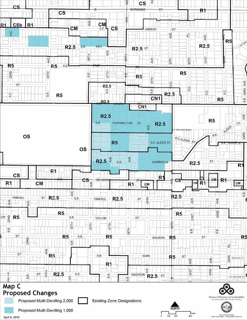
2 N
o.
July
201
5 Pr
opos
al
Loca
tion
Test
imon
y Re
com
men
datio
ns
Ratio
nale
3 N
one
Mul
ti-dw
ellin
g de
velo
pmen
t on
SE
22nd
, SE
24th
and
SE
26th
, be
twee
n SE
An
keny
and
SE
Ash
(Buc
kman
)
Appl
y R1
des
igna
tion
to
R2.5
pro
pert
ies c
urre
ntly
de
velo
ped
at a
no
ncon
form
ing
resid
entia
l den
sity
(pro
pert
y ow
ners
and
in
divi
dual
s).
Appl
y R1
des
igna
tion
to m
ultip
le R
2.5
prop
ertie
s as r
eque
sted
. �
See
Map
C
Ackn
owle
dge
exist
ing
resid
entia
l dev
elop
men
t an
d av
oid
nonc
onfo
rmin
g sit
uatio
n.
4 R2
.5�
R2
Mul
ti-dw
ellin
g de
velo
pmen
t be
twee
n SE
31st
an
d SE
32nd
Av
enue
, sou
th
of P
owel
l Blv
d (C
rest
on-
Keni
lwor
th)
Appl
y R1
des
igna
tion
to
R2.5
pro
pert
ies a
djac
ent
to R
1 pr
oper
ties a
nd
deve
lope
d at
no
ncon
form
ing
resid
entia
l den
sity
(indi
vidu
al).
No
chan
ge to
pro
pose
d m
ap.
Ackn
owle
dge
exist
ing
resid
entia
l dev
elop
men
t an
d av
oid
nonc
onfo
rmin
g sit
uatio
n. T
his a
rea
is cu
rren
tly b
eing
stud
ied
in th
e Po
wel
l-Div
ision
Tr
ansit
and
Dev
elop
men
t Pro
ject
and
may
be
exam
ined
in th
e co
ntex
t of a
futu
re st
atio
n ar
ea
plan
ning
pro
cess
.
5 n/
a SE
Woo
dwar
d an
d SE
Bro
okly
n St
reet
s, b
oth
east
and
wes
t a
half
bloc
k fr
om
SE C
esar
E.
Chav
ez B
lvd
(Ric
hmon
d)
Appl
y R2
.5 d
esig
natio
n to
R5
pro
pert
ies d
evel
oped
at
non
conf
orm
ing
resid
entia
l den
sity
(sta
ff).
Appl
y R2
.5 d
esig
natio
n to
R5
prop
ertie
s.
� S
ee M
ap D
Ackn
owle
dge
exist
ing
resid
entia
l dev
elop
men
t an
d av
oid
nonc
onfo
rmin
g sit
uatio
n. T
his a
rea
is de
velo
ped
with
dup
lexe
s and
smal
l apa
rtm
ent
build
ings
. The
pro
posa
l wou
ld b
e co
nsist
ent w
ith
adja
cent
R2.
5 zo
ning
to th
e no
rth.

3 N
o.
July
201
5 Pr
opos
al
Loca
tion
Test
imon
y Re
com
men
datio
ns
Ratio
nale
6 n/
a M
ulti-
dwel
ling
deve
lopm
ent a
t 33
32-3
344
SE
Cesa
r E C
have
z Bl
vd
(Ric
hmon
d)
Appl
y R1
des
igna
tion
to
R2.5
pro
pert
y sp
lit-z
oned
R1
/R2.
5 an
d de
velo
ped
at
nonc
onfo
rmin
g re
siden
tial d
ensit
y (in
divi
dual
).
Appl
y R1
des
igna
tion
as re
ques
ted.
�
See
Map
D
Rect
ify a
split
-des
igna
ted
site
and
to
ackn
owle
dge
exist
ing
resid
entia
l dev
elop
men
t an
d av
oid
nonc
onfo
rmin
g sit
uatio
n.
7 n/
a
East
of S
E Pe
acoc
k La
ne to
SE
42nd
, nor
th
of S
E Be
lmon
t to
SE
Star
k St
reet
s (S
unny
side)
- App
ly R
1 de
signa
tion
to
R2.5
pro
pert
ies
deve
lope
d at
no
ncon
form
ing
resid
entia
l den
sity
(indi
vidu
al).
- App
ly M
U d
esig
natio
n to
lo
ts fr
ontin
g SE
Bel
mon
t (S
unny
side
NA)
.
Appl
y R2
to p
rope
rtie
s bet
wee
n Be
lmon
t and
Sta
rk. A
pply
R1
desig
natio
n to
pro
pert
ies f
ront
ing
on
SE B
elm
ont.
�
See
Map
E
Ackn
owle
dge
exist
ing
resid
entia
l dev
elop
men
t an
d av
oid
nonc
onfo
rmin
g sit
uatio
n. R
1 de
signa
tion
on B
elm
ont m
atch
es zo
ning
on
the
sout
h sid
e of
Bel
mon
t; M
U d
esig
natio
n is
not
war
rant
ed a
t thi
s tim
e.
8 n/
a 38
66 S
E Ta
ylor
St
, 390
7-39
11
SE S
alm
on S
t, 12
20-1
230
SE
Cesa
r E C
have
z Bl
vd
(Sun
nysid
e)
Appl
y R1
des
igna
tion
to
R2.5
pro
pert
ies
deve
lope
d at
no
ncon
form
ing
resid
entia
l den
sity
(indi
vidu
al).
Appl
y R1
des
igna
tion
to R
2.5
prop
ertie
s as r
eque
sted
. �
See
Map
E
Ackn
owle
dge
exist
ing
resid
entia
l dev
elop
men
t an
d av
oid
nonc
onfo
rmin
g sit
uatio
n.


![2011 09 29 Reply Memo ISO MTC Ranadive Depo [Public Version]](https://img.pdfslide.us/doc/110x75/54124d7e7bef0ab7058b46fa/2011-09-29-reply-memo-iso-mtc-ranadive-depo-public-version.jpg)