Embed Size (px)
Citation preview
City of Redlands - Redlands Crossing Center Draft EIR Land Use and Planning
Michael Brandman Associates 3.9-1 H:\Client (PN-JN)\0629\06290016\EIR\2 - EIR\06290016_Sec03-09_Land_Use_and_Planning.doc
3.9 - Land Use and Planning
3.9.1 - Introduction This section describes the existing setting regarding land use and planning and potential effects from Project implementation on the site and its surrounding area. Section 15125 of the State CEQA Guidelines requires EIRs to include a description of the physical environmental conditions in the area of a project that exist at the time that the Notice of Preparation (NOP) is circulated. These environmental conditions normally constitute the baseline physical conditions relative to which the CEQA lead agency evaluates the change in conditions that would result from project implementation. The NOP for this Draft EIR was issued on February 27, 2009. Therefore, environmental conditions as of February 2009 represent the baseline for CEQA purposes. To evaluate the footprint impacts of the Proposed Action (e.g., effects on Land Use and Planning), the conditions in 2009 are considered to be the baseline. Buildout of the Project is then added to existing conditions in order to determine whether Project implementation would substantially remove or impact the resources, thereby resulting in a significant impact on the environment. Data used to determine the baseline for Land Use and Planning were derived from site reconnaissance by MBA, review of the City of Redlands General Plan amended on December 12, 1997, the East Valley Corridor Specific Plan (EVCSP) revised last by the City on February 16, 2010 and biological technical studies completed for the Project (Section 3.4, Biological Resources). Therefore, data used to derive baseline conditions is based on existing conditions at the time of NOP issuance (February 27, 2009 through March 31, 2009) and are appropriate to use within the following analysis.
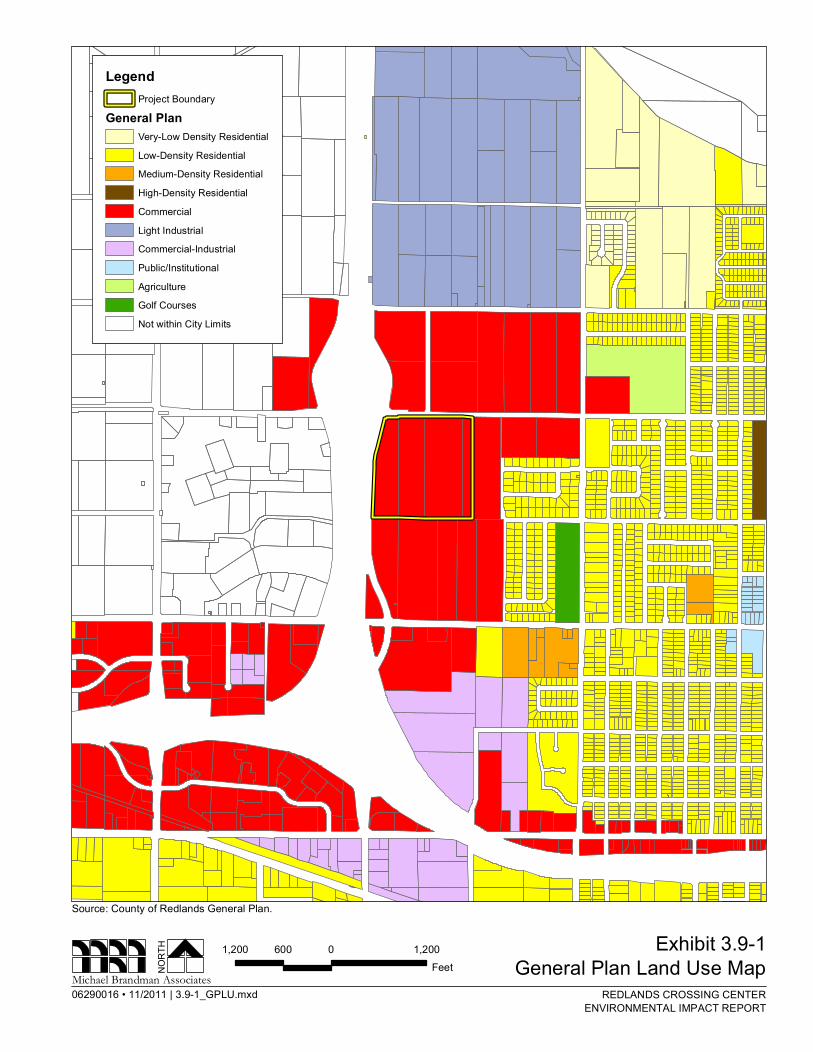
3.9.2 - Environmental Setting According to the Phase I Environmental Site Assessment (KA 2006), historically the Project site has been utilized primarily for agricultural purposes as an orchard from at least 1938 until approximately 2002. Three single-family residential structures occupied the northeast corners of Parcels 01 and 02 and the northern boundary of Parcel 04 from at least 1938 until the demolition of the dwellings on Parcels 01 and 04 in approximately the early 1990s. The Project site currently consists of primarily vacant land with a number of untended orchard trees that are remnants of its past use as an orchard. Surrounding land uses include mostly vacant and inactive or abandoned farmland to the north, northeast, and south with the exception of the residential subdivision to the east. State Route 210 (SR-210) is approximately 0.25 mile west of the Project site. Exhibit 3.9-1 General Plan Land Use Map provides an aerial view of surrounding land designations.
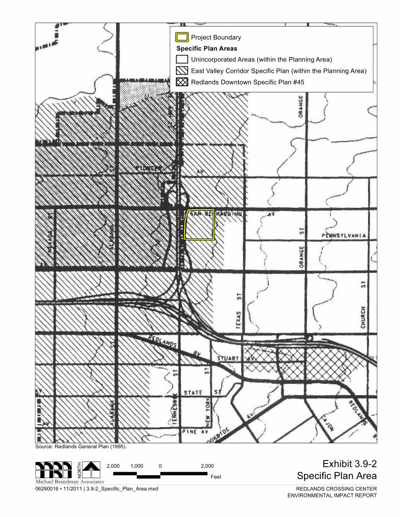
The Project site is designated Commercial (C) per the City of Redlands General Plan Land Use Map (November 2010). This commercial designation allows for a variety of commercial activities ranging shopping center to business parks. The Project site is also within the boundaries of the East Valley Corridor Specific Plan, and Cities Pavilion Concept Plan (Exhibit 3.9-2 Specific Plan Area). The Cities Pavilion Concept Plan functions as a development suitability analysis and land use plan which identifies development opportunities and constraints within the Development Envelope, including
City of Redlands - Redlands Crossing Center Land Use and Planning Draft EIR
3.9-2 Michael Brandman Associates H:\Client (PN-JN)\0629\06290016\EIR\2 - EIR\06290016_Sec03-09_Land_Use_and_Planning.doc
physical characteristics, public services and facilities, capacity of the circulation system, and existing or planned uses or adjacent properties. The intent of the Concept Plan is to establish limits, parameters, and planning objectives to guide development based on the identified development constraints and opportunities.
According to the City of Redlands Zoning Map (November 2010), the Project site is zoned as East Valley Corridor Specific Plan and Concept Plan No.4 (CP4). Allowable uses within CP4 Zone include General Commercial District (GC) and Administrative Professional (AP). The General Plan designation for surrounding area of the Project site is designated as Commercial, with the exception of Low-Density Residential to the east. Surrounding Zoning within the Project area include East Valley Special Development (EV/SD) to the north and south; Concept Plan No.4 (CP4) and single family residential (R-S) to the east; and East Valley Corridor Specific Plan, Regional Commercial (EV/CR) to the west.
3.9.3 - Regulatory Framework Regional Plans & Regulations Southern California Association of Governments (SCAG) SCAG is the regional association of governments for the counties of Orange, Los Angeles, San Bernardino, Riverside, and Imperial. Regional associations of governments were created by the State to guide land use decisions that overlap multiple local jurisdictions by creating joint powers of agreement between these localities, and to provide policy guidance in the region. SCAG is Southern California’s forum for addressing regional issues concerning transportation, the economy, community development and the environment. As a Metropolitan Planning Organization (MPO), SCAG’s main responsibilities under State and federal law are implementing the Regional Transportation Plan (RTP) and the Regional Housing Needs Assessment (RHNA). The RTP involves preparation of long-range transportation plans and development and adoption of transportation improvement programs that allocate State and federal funds for highway, transit and other surface transportation Projects. Although SCAG does not have formal regulatory authority and, therefore, cannot directly implement land use decisions, SCAG guides land use planning for the region through intergovernmental coordination and consensus building. SCAG serves as the regional clearinghouse for Projects requiring environmental documentation under State and federal law. In this role, SCAG reviews proposed development and infrastructure Projects within Southern California to analyze their potential impacts on regional planning programs (SCAG 2004).
SCAG Compass Plan The SCAG has recently adopted its “Compass Plan” to monitor and manage regional growth. This plan identifies a “2 Percent Strategy” that attempts to concentrate just two percent increase of new growth near freeways and transit routes to help reduce regional congestion.
06290016 • 11/2011 | 3.9-1_GPLU.mxd
Exhibit 3.9-1General Plan Land Use MapNO
RTH
Michael Brandman Associates
Source: County of Redlands General Plan.
REDLANDS CROSSING CENTERENVIRONMENTAL IMPACT REPORT
1,200 0 1,200600Feet
LegendProject Boundary
General PlanVery-Low Density ResidentialLow-Density ResidentialMedium-Density ResidentialHigh-Density ResidentialCommercialLight IndustrialCommercial-IndustrialPublic/InstitutionalAgricultureGolf CoursesNot within City Limits

06290016 • 11/2011 | 3.9-2_Specific_Plan_Area.mxd
Exhibit 3.9-2Specific Plan AreaNO
RTH
Michael Brandman Associates
Source: Redlands General Plan (1995).
REDLANDS CROSSING CENTERENVIRONMENTAL IMPACT REPORT
2,000 0 2,0001,000Feet
Project BoundarySpecific Plan Areas
Unincorporated Areas (within the Planning Area)East Valley Corridor Specific Plan (within the Planning Area)Redlands Downtown Specific Plan #45

City of Redlands - Redlands Crossing Center Draft EIR Land Use and Planning
Michael Brandman Associates 3.9-7 H:\Client (PN-JN)\0629\06290016\EIR\2 - EIR\06290016_Sec03-09_Land_Use_and_Planning.doc
This “Compass Growth Vision” incorporates four goals: 1) focus growth in existing and emerging centers and along major transportation corridors; 2) create significant areas of mixed-use development and walkable communities; 3) target growth around existing and planned transit stations; and 4) preserve existing open space and stable residential areas.
Santa Ana Regional Water Quality Control Board (SARWQCB) A description of SARWQCB is provided in Section 3.8, Hydrology and Water Resources, under Section 3.8.3 (Regulatory Framework).
South Coast Air Quality Management District (SCAQMD) A description of SCAQMD is provided in Section 3.3, Air Quality, under Section 3.3.3 (Regulatory Framework).
Local Plans & Regulations City of Redlands Plan Goals and Policies The Land Use Element of the City of Redlands General Plan contains goals and policies that function as a hierarchy and provide the basis for decision-making regarding the City’s long-term physical development. Land use goals are broad statements that identify the land use character of the City. Land use policies are specific statements describing desired results that commit the City to courses of action.
EVCSP was adopted by the City in January 3, 1989 to refine General Plan policies for the Project area. The EVCSP is consistent with the land use map, land use element of the General Plan; however, the standards of the development within EVCSP are specific to this planning area, and are not expressly part of the General Plan. The following policies within the EVCSP are applicable in general to the Project:
Guiding Policies: East Valley Corridor 4.62g Promote high quality development in the East Valley Corridor (EVC) by protecting
and enhancing existing amenities in the area, creating an identifiable community character, and adopting development standards and guidelines to ensure aesthetically pleasing design and maximum land use compatibility.
Implementing Policies: East Valley Corridor 4.62l Maximize generation of employment opportunities in a region, which has a
significant imbalance of housing versus employment opportunities.
4.62m Facilitate location in the project area of a wide range of commercial uses to serve the region, local industry, and residential neighborhoods.
The EVCSP has set-forth the following guidelines related specific for commercial/industrial areas.
City of Redlands - Redlands Crossing Center Land Use and Planning Draft EIR
3.9-8 Michael Brandman Associates H:\Client (PN-JN)\0629\06290016\EIR\2 - EIR\06290016_Sec03-09_Land_Use_and_Planning.doc
Guiding Policies: Commercial/Industrial Areas 4.70a Provide commercial/industrial sites appropriate for the wide range of uses
encompassed by the category.
Implementing Policies: Commercial/Industrial Areas 4.70b In the EVC north of I-10 require Planned Development projects consistent with the
Special Development District of the EVCSP.
Although most standards will be set by the Planned Development approval, East Valley Corridor standards require a minimum of 15 to 20 percent landscaped area and other design standards characteristic of business park.
The land use zone in the City is regulated by Title 18 of the Redlands Municipal Code. The Project site is designated Commercial (C) per the City of Redlands General Plan Land Use Map (November 2010). This commercial designation allows for a variety of commercial activities ranging shopping center to business parks. The Project site is also within the boundaries of the East Valley Corridor Specific Plan, Cities Pavilion Concept Plan. According to the City of Redlands Zoning Map (November 2010), the Project site is zoned as East Valley Corridor Specific Plan and Concept Plan No.4 (CP4). Allowable uses within CP4 Zone include General Commercial District (GC) and Administrative Professional (AP). The following is a generalized listing of the permitted land uses with the exception of conditionally permitted land uses.
General Commercial. The General Commercial Land use designation permits the following uses:
• Agriculture;
• Uses permitted in the Neighborhood Commercial District and Administrative Professional District (see below);
• Retail sales of goods generally characterized by relatively long-term utility or consumptions; examples include department and general merchandise stores and home improvement centers;
• Provision of services to individuals and business establishments; examples include automobile rental and eating establishments (including on-site sale of alcoholic beverages) with the exception of drive-through restaurants, which shall require a Conditional Use Permit; and
• Repair and servicing of any article, which is permitted to be sold in this District. Additional uses permitted by the Neighborhood Commercial designation include the following:
• Uses permitted in the Administrative/Professional District (see below);
• Retail sale of goods generally characterized by relatively short-term utility or consumption; examples include apparel, drug stores, and groceries; and
City of Redlands - Redlands Crossing Center Draft EIR Land Use and Planning
Michael Brandman Associates 3.9-9 H:\Client (PN-JN)\0629\06290016\EIR\2 - EIR\06290016_Sec03-09_Land_Use_and_Planning.doc
• Provision of services which are typically frequently or recurrently and which primarily care for the needs of individuals and households rather than business; examples include barbershops, dry-cleaners, and video rentals.
Administrative Professional District. The Administrative Professional land use designation permits the following uses:
• Professional services, such as accounting, legal services, physicians, and dentists; • Business services, such as consulting, secretarial, and employment agencies; • Financial services, such as banks, investment services, real estate agents; and • Miscellaneous services, such as business associations, libraries, and museums.
NOP Comment Letters
A Notice of Preparation (NOP) comment letter was provided by the County of San Bernardino Land Use Services Department on September 10, 2007. The Land Use Services Department stated that land use compatibility, safety, and security issues associated with a 24-hour/day business/operation, proposal of an indoor arcade, and proximity to schools should be evaluated as part of the Draft EIR.
A NOP comment letter was provided by the Redlands Association on September 17, 2007. The Redlands Association stated that all environmental impacts must be evaluated with in the bounds of the City's General Plan. This includes full mitigation of all impacts affecting city services including infrastructure and public safety services, as well as noise, light and glare, traffic, etc.
3.9.4 - Thresholds of Significance According to the California Environmental Quality Act (CEQA) Guidelines’ Appendix G Environmental Checklist, to determine whether hazards and hazardous materials are significant environmental effects, the following questions are analyzed and evaluated:
a) Physically divide an established community?
b) Conflict with any applicable land use plan, policy, or regulation of an agency with jurisdiction over the project (including, but not limited to the general plan, specific plan, local coastal program, or zoning ordinance) adopted for the purpose of avoiding or mitigating an environmental effect?
c) Conflict with any applicable habitat conservation plan or natural communities conservation plan?
3.9.5 - Project Impacts and Mitigation Measures This section discusses potential impacts associated with the development of the project and provides mitigation measures where appropriate.

City of Redlands - Redlands Crossing Center Land Use and Planning Draft EIR
3.9-10 Michael Brandman Associates H:\Client (PN-JN)\0629\06290016\EIR\2 - EIR\06290016_Sec03-09_Land_Use_and_Planning.doc
Divide Established Community
Impact LUP-1 Physically divide an established community? [CEQA Land Use and Planning 10(a)]
Impact Analysis The Project will be constructed on vacant and undeveloped land. The Project site does not consist of any established communities. A residential neighborhood exists along Karon Street, the eastern boundary of the Project site. However, the remaining areas adjacent to the Project site are undeveloped and vacant. Therefore, the Project does not have the potential to divide an established community so this impact is less than significant.
Level of Significance Before Mitigation Less than significant.
Mitigation Measures No mitigation required.
Level of Significance After Mitigation Less than significant
Conflict with Applicable Plans, Policies, or Regulations
Impact LUP-2 Conflict with any applicable land use plan, policy, or regulation of an agency with jurisdiction over the project (including, but not limited to the general plan, specific plan, local coastal program, or zoning ordinance) adopted for the purpose of avoiding or mitigating an environmental effect?
[CEQA Land Use and Planning 10(b)]
Impact Analysis The Project site is within the jurisdiction of City of Redlands and is therefore subject to the City’s General Plan goals and policies. The Project site is also located within the EVCSP to refine the City’s General Plan policies for the Project area. The purpose of the EVCSP is to plan for large undeveloped areas located along I-10 in the Redlands and Loma Linda area to provide guidance for future industrial, commercial, and residential development in an orderly and aesthetic manner. The objectives of the EVCSP are to provide a well-planned community that attracts major businesses into the area to provide a job base for the surrounding area and strengthen the local economy, while ensuring high-quality development through design guidelines and standards. Therefore, the Project is subject to both the City’s General Plan and EVCSP goals and policies.
Consistency with City of Redlands General Plan
Table 3.9-1 provides an analysis of consistency with policies in the City of Redlands General Plan that directly relates to the mix of land uses in the EVC.

City of Redlands - Redlands Crossing Center Draft EIR Land Use and Planning
Michael Brandman Associates 3.9-11 H:\Client (PN-JN)\0629\06290016\EIR\2 - EIR\06290016_Sec03-09_Land_Use_and_Planning.doc
Table 3.9-1: Analysis of Consistency with Applicable General Plan Policies
Goal/Policy Consistency Analysis Consistent?
Policy 4.62a Develop the East Valley Corridor Specific Plan (EVCSP) so as to promote and facilitate high-quality commercial and industrial development within the corridor area.
The Project proposes to develop approximately 275,500 square feet of commercial and retail uses that will promote and facilitate high-quality commercial development within the Corridor Area.
Yes
Policy 4.62l Maximize generation of employment opportunities in a region, which has a significant imbalance of housing versus employment opportunities.
The Project would provide numerous employment opportunities through the addition of substantial commercial and retail uses. It is estimated that the Project will generate approximately 436 jobs with approximately 230 of the 436 jobs being from the existing Walmart. The Project would develop up to 275,500 square feet of commercial, retail uses that would translate into a wide range of new employment opportunities and thus contribute to a more balanced job-housing ratio in the surrounding area.
Yes
Policy 4.62m Facilitate location in the project area of a wide range of commercial uses to serve the region, local industry, and residential neighborhoods.
The EVSCP designates the Project area as Special Development District, which is a generalized commercial, industrial, and institutional land use designation. The Project is a commercial, retail, and future office use development located in close proximity to Highway 30, I-10 and SR-210 Freeway serving the region, and the surrounding community.
Yes
Policy 4.62z Designate land uses so as to reduce the number and length of vehicle trips in the East Valley Corridor.
The proposed development in virtue of its nature (commercial, retail use and future office) will reduce the dependences on automobiles for employment and service-related trips by encouraging pedestrian activity within the proposed development. The Project is also located within walking distance of the existing residential neighborhood development to the east and a planned mixed-use development to the north further reducing vehicular trips.
Yes
Consistency with East Valley Corridor Specific Plan (EVCSP)
The Project is within the EVCSP, which serves as the principal land use planning document-guiding development within the EVCSP planning area of the City of Redlands. According to the EVCSP Final EIR (October 1988), land use was determined to have a significant and unavoidable impact due to the near total elimination of prime agricultural lands at EVCSP buildout. A statement of overriding considerations was determined in October 1988, regarding EVCSP land uses. Table 3.9-2 provides an analysis of consistency with policies in the EVCSP that directly relates to the Project.

City of Redlands - Redlands Crossing Center Land Use and Planning Draft EIR
3.9-12 Michael Brandman Associates H:\Client (PN-JN)\0629\06290016\EIR\2 - EIR\06290016_Sec03-09_Land_Use_and_Planning.doc
Table 3.9-2: Analysis of Consistency with Applicable EVCSP Policies
Goal/Policy Consistency Analysis Consistent?
Goal EV2.0205 (a) Develop the East Valley Corridor Specific Plan so as to promote and facilitate high-quality commercial and industrial development within the corridor area.
Goal EV2.0205 (a) of the EVSCP is identical to Policy 4.62a of the General Plan, discussed in this section. Refer to above discussion.
Yes
Policy EV2.0205 (a) (1) Maximize generation of employment opportunities in a region, which has a significant imbalance of housing versus employment opportunities.
Policy EV2.0205 (a) (1) of the EVSCP is identical to Policy 4.62l of the General Plan, discussed in this section. Refer to above discussion.
Yes
Policy EV2.0205 (a) (2) Facilitate location in the project area of a wide range of commercial uses to serve the region, local industry, and residential neighborhoods.
Policy EV2.0205 (a) (2) of the EVSCP is identical to Policy 4.62m of the General Plan, discussed in this section. Refer to above discussion.
Yes
Policy 4.62n Designate land uses so as to reduce the number and length of vehicle trips in the East Valley Corridor.
Policy EV2.0205 (a) (2) of the EVSCP is identical to Policy 4.62m of the General Plan, discussed in this section. Refer to above discussion.
Yes
The Project is consistent with existing applicable land use policies and designations of the Redlands General Plan and EVSCP. In addition, the proposed development would be in accordance with the land use designations identified in the City’s General Plan and EVSCP. Therefore, the Project would not conflict with applicable plans, policies, or regulations, and would be less than significant.
Level of Significance Before Mitigation Less than significant
Mitigation Measures No mitigation required
Level of Significance After Mitigation Less than significant
Conflict with Conservation Plans
Impact LUP-3 Conflict with any applicable habitat conservation plan or natural communities conservation plan?
[CEQA Land Use and Planning 10(c)]
Impact Analysis There are no applicable habitat conservation plans or natural community conservation plans that apply to the Project site, therefore, the Project will not have a significant impact associated with conflicts with applicable habitat conservation plans or natural community conservation plans. See Section 3.4, Biological Resources, for additional discussions in this regard.

City of Redlands - Redlands Crossing Center Draft EIR Land Use and Planning
Michael Brandman Associates 3.9-13 H:\Client (PN-JN)\0629\06290016\EIR\2 - EIR\06290016_Sec03-09_Land_Use_and_Planning.doc
Level of Significance Before Mitigation Less than significant impact.
Mitigation Measures No mitigation required.
Level of Significance After Mitigation Less than significant impact.