Embed Size (px)
Citation preview

04/07/10
Web Services and Mobile solutions
Ken Mathers
Senior Consultant NZ

04/07/10 2
What are Web Services
• Method to distribute data without copying
• Used to provide data for Web applications
• Used to supply Vector, Raster and catalog data
• Includes discoverability
• Simplify End User role
• Includes security and roles

04/07/10 3
Web Services and SDI
SDI concepts (Spatial Data Infrastructure)
• Maintain data in source format
• Store data only once
• ‘Access’ data rather than copy it
• Principles validated at recent Plugfest
• Standards
• OGC Compliant WFS, WMS, WCS, etc
• Any other agreed standards. (The great thing about standards is that there are so many of them…)

04/07/10 4
Example configuration (Christchurch example)

04/07/10 5
Example Portal configuration

04/07/10 6
Example Web Services in practice
04/07/10 7
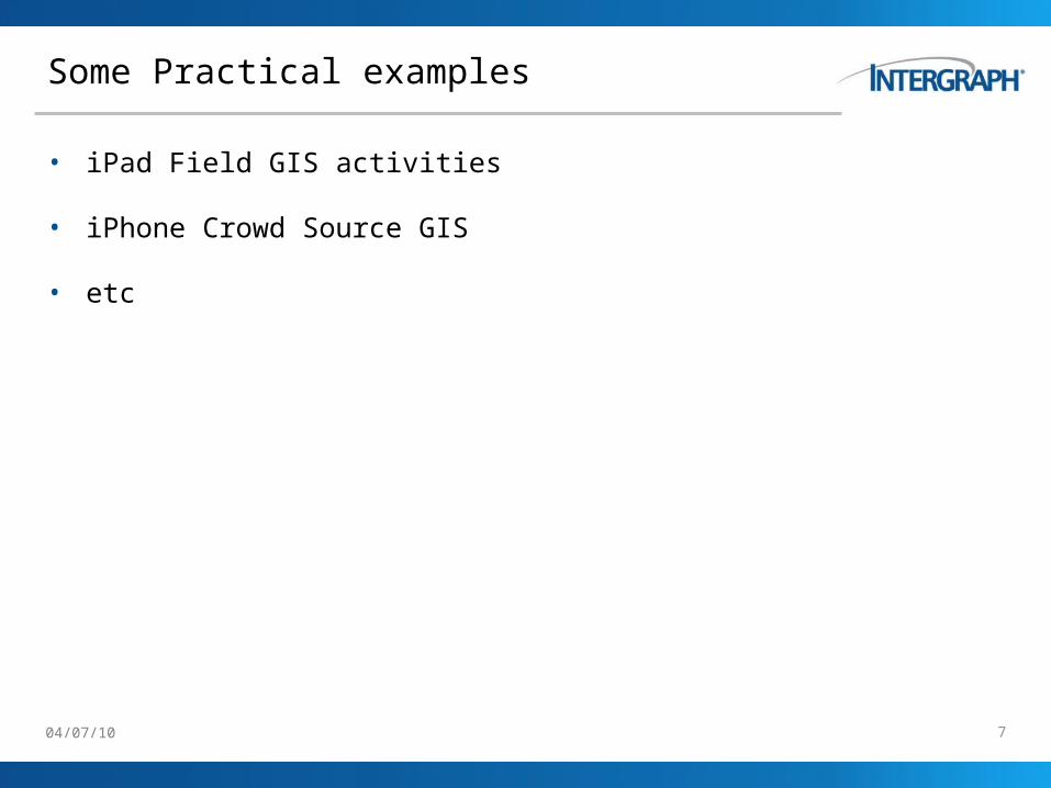
Some Practical examples
• iPad Field GIS activities
• iPhone Crowd Source GIS
• etc

04/07/10 8
Intergraph Mobile Maps [HD]
Mobile Maps [HD] for view/edit on iPad
Mobile Maps for viewing on iPhone

04/07/10 9
Value Proposition
• Need to see, edit and update spatial data in the field in real time Business Problem
• Intergraph Mobile Maps for iPhone• Intergraph Mobile Maps HD for iPadSolution
• Easy to setup and get started• No need for data export / import• Full OGC support
Benefits
• Add barcode (QR) scanner• Augmented reality• Migration to Android smartphone and tablets
Future Plans

04/07/10
App architecture – based on modules
Intergraph Mobile Maps
Map
Park areas Road equipment
Street equipment
Emergency Info
Configuration

04/07/10 13
User management
If the device is registered with Intergraph the user can log in with username & password
For high security implementations the solution supports two-factor login using OTP-tokens (one time passwords)
Access control is implemented in the following ways;
– Device ID (UUID)
and/or
– Username/password
and/or
– OTP-token

04/07/10 14
User management
If the user is authorized a list of configurations assigned to the user is listed
Each configuration is defined by an administrator using XML
Unlimited number of configurations can be implemented if demanded
Configuration-XML is described elsewhere

04/07/10 15
User Interface (iPad) - Overall
The user interface consists of a large map window and a top toolbar
The top tool bar has the following buttons/functions (from left to right);
– Centre map on current GPS-coordinate
– Open Layer menu
– Load new configuration (returns to configuration list)
– Add new feature (only visible if at least one
editable feature class exists in the configuration)

04/07/10 24
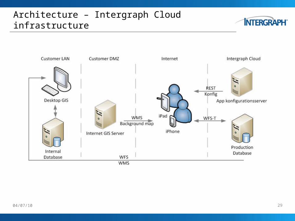
Architecture – overall
The solution can be implemented in every existing “GIS infrastructure” that is OGC-compliant;
– WMS
– WFS
– WFS-T (transactional WFS)
If the customer’s infrastructure supports WFS but not WFS-T the solution has an option to include a “WFS-T proxy” that can be implemented as an alternative
If the customer do not have an OGC-compliant infrastructure Intergraph can host the solution in Intergraph’s Amazon cloud-infrastructure
The next slides will show a variety of possible implementations …

04/07/10 25
Architecture – Customer infrastructureDMZ, WFS-T

04/07/10 26
Architecture – Customer infrastructureDMZ, no WFS-T

04/07/10 27
Architecture – Customer infrastructureLAN + WFS-T

04/07/10 28
Architecture – Customer infrastructureLAN, no WFS-T
04/07/10 29
Architecture – Intergraph Cloud infrastructure

04/07/10 33
Intergraph Mobile Alert
Mobile Alert – iPhone app for field mapping
Crowdsourcing: A Definition
Crowdsourcing is the act of taking a job traditionally performed by a designated agent (usually an employee) and outsourcing it to an undefined, generally large group of people in the form of an open call

04/07/10 34
Value Proposition for Authorities and Citizens
•Simplify reporting of potholes, broken sign posts, graffiti etc. to municipalities and utility companies.•Empowering citizens!
Business Problem
•Reporting app to submit directly from any smartphone.
Solution
•Citizens help municipalities and utility companies to identify the problems and can focus on solving the problems instead of identifying them.•Potential feedback to reports – my council does notice!
Benefits
•Mobile maps, augmented reality applications, customised apps
Future Plans/Strategy or Summary Statement

04/07/10 35
Mobile Alert – What’s it all about
Is an easy tool for citizens to report incidents to the municipalities, utility companies and other territorial authorities.
It works on both iOS and Android devices
The backend is running in Amazon’s EC2 cloud
The backend is based on GeoMedia WebMap and SDI Pro
Bing Address Service is used for geocoding incoming incidents
Cloud service from Intergraph global

04/07/10 36
Mobile Alert – New Zealand App
12 categories
– Waste on Street
– Pothole
– Graffiti
– Overflowing rubbish
– Broken pavement
– Wrong signage
– Disaster damage
– Broken signpost
– Dead animals
– No/broken streetlight
– Vandalism
– Other
Single App for all NZ entities – uses TLA boundary data
Intergraph will host the service in the Cloud
Subscription service by councils and utilities
Plan to start operating soon

04/07/10 37
Proposed New Zealand subscriptions
The municipalities and utility companies can subscribe to Mobile Alert
3 types of subscriptions: Gold, Silver and Bronze
– Bronze sends the incidents daily by email for free (!)
– Silver sends to up to 12 email addresses with more detailed information
– Gold gives real-time access to a range of webservices with WFS feed
Alternatively, we can implement dedicated internal solutions using the same architecture

04/07/10 38
Mobile Alert Service Oriented Architecture
04/07/10
Thank You ! Questions?
Ken MathersSecurity, Government & Infrastructure
Phone +64 4 914.1200 - 1204Cell phone +64 21 442 289 Fax +64 4 [email protected]
1 Willeston StWellington
New Zealandwww.intergraph.com
Intergraph NZ

04/07/10
Thank You!


![[PPT]PowerPoint Presentation - Yolaecswebpage.yolasite.com/resources/Marshal Mathers III.pptx · Web view“IM SHADY!” By: Eric R. Curtis Marshal Mathers III E EMIN M Eminem’s](https://img.pdfslide.us/doc/110x75/5aa420b57f8b9a7c1a8bb880/pptpowerpoint-presentation-mathers-iiipptxweb-viewim-shady-by-eric.jpg)