Embed Size (px)
Citation preview

Perspective Plan for Development of Tawang River Basin
North-Eastern Hill University, Shillong i
Executive Summary
0.1 Introduction
Among the major sources of energy production such as nuclear, thermal and hydel, hydel is the least polluting
source of power generation. The contribution of non-renewable energy sources such as wind, solar and tidal
being insignificant, today hydel power seems to be the preferred source of power generation for India. Although
construction of HEP projects is essential to generate electricity for the development of the northeastern region,
the prime victim of this development will be the biodiversity rich forests and mountain ecosystems.
A total of 13 hydro electric power projects with total capacity of about 2890.10 MW have been planned in
Tawang river basin in Arunachal Pradesh including three projects of over 500 MW capacity, seven projects of
less than 100 MW capacity and three projects of less than 50 MW capacity (Table 0.1 and Figure 0.1).
Table 0.1: Details of the proponents of the 13 hydro electric projects planned to be constructed in Tawang river
basin Name of project Name of implementing agency Revised/proposed
capacity (MW)
Elevation (m asl)
Tsa Chu- I Energy Development Co. Ltd., Faridabad 24.00 3350
Tsa Chu- I Lower Energy Development Co. Ltd., Faridabad 77.20 3245
Tsa Chu- II Energy Development Co. Ltd., Faridabad 67.00 3170
Thingbu Chu Arunachal Pradesh Mega Power Projects Pvt. Ltd., New Delhi
60.00 2800
New Melling Sew Energy Ltd., Hyderabad 90.00 2786
Mago Chu Sew Energy Ltd. 96.00 2456
Nykcharong Chu Sew Energy Ltd. 96.00 2460
Rho Sew Energy Ltd. 93.00 2240
Tawang-I NHPC Ltd., Faridabad 750.00 2092
Tawang-II NHPC Ltd., Faridabad 750.00 1536
Nyamjang Chu Bhilwara Energy Ltd., Noida 780.00 2115
Paikangrong Chu SMJ Consultants Pvt. Ltd., New Delhi 2.40 2150
Jaswantgarh Stage- I SMJ Consultants Pvt. Ltd., New Delhi 4.50 3357
Total 6 2890.10
Figure 0.1: Proposed locations of the hydroelectric power projects in Tawang river basin

Perspective Plan for Development of Tawang River Basin
North-Eastern Hill University, Shillong ii
No human population or habitation will be displaced due to implementation of the proposed HEP projects since
all the projects are run-of-the-river schemes, and do not involve the creation of reservoir. However, the unique
biodiversity, undisturbed high forests, and rich cultural diversity of Tawang river basin will be affected if these
projects are implemented. The destruction of habitats of the threatened and endemic flora and fauna of the basin
may have detrimental impact on already dwindling populations of these floral and faunal elements. The
developmental needs of the region which have been hitherto neglected might be taken care of as an ancillary
benefit if these projects are taken up. However, the environmental damage to be caused by such projects cannot
be undermined. Therefore, a balanced approach needs to be worked out with an aim to optimize power
production with minimum environmental damage. This approach has to be at a basin scale considering all the
proposed projects rather following single project approach.
While considering the accordance of forest clearance for Tawang-I and Tawang-II projects, the Forest Advisory
Committee (FAC) of the Ministry of Environment and Forests, Government of India desired that the
Government of Arunachal Pradesh should conduct a study on Tawang river basin with the following objectives:
1. To assess the impact of thirteen hydro-electric projects planned in the basin, ancillary
industries/activities, including influx of migrant workers, displacement of local ST population etc., on
local ecology and biodiversity,
2. To assess the ecological water flow at different places along Tawang river and its tributaries.
3. To prepare a biodiversity management plan at the landscape level for the river basin.
4. To prepare a 15-20 years perspective plan for the cumulative development of the Tawang river basin.
5. To assess carrying capacity of Tawang river basin.
The Government of Arunachal Pradesh commissioned North-Eastern Hill University (NEHU), Shillong to
conduct the above study based on the recommendation of the ‘Technical Committee’ of Government Arunachal
Pradesh. A Memorandum of Association (herein after referred as MoA) was signed between the North-Eastern
Hill University (NEHU) and Government of Arunachal Pradesh to complete the study.
The scope of the study as mentioned in the MoA in Tawang river basin include:
1. Impact Assessment of Individual projects: Geology and geomorphology, seismicity, hydro–
meteorology, land use/land cover, vegetation and soil environment, floral and faunal elements, aquatic
ecology and water quality, fish and fisheries, air pollution, socio–cultural and economic profile,
prediction of impacts both cumulative as well as at individual project level. More specifically, the
overall impact of the projects on hydrology, biodiversity, ecology of the area especially the river
ecosystems and the vegetation in the adjoining land area was to be assessed. The impact of the projects
on livelihood including displacement of the people and consequent pressures on the environment has to
be adequately assessed and addressed.
2. Cumulative Impact Assessment: Cumulative Impact Assessment study for Tawang river basin
3. Assessment of E-Flow: An assessment of minimum ecological water flow at different places along
Tawang River and its tributaries was to be made. The parameters of all the projects have to be adjusted
to ensure this ecological water flow.
4. Assessment of Carrying Capacity: The carrying capacity of the river basin in terms of water
resources, forest resources, biodiversity and human population was to be assessed.
5. Twenty Year Perspective Development Plan: Since a large numbers of projects are planned on the
river system, a perspective development plan for the entire river basin was to be prepared. A proper
disaster management plan keeping in view all the projects also needs to be prepared.
6. Landscape Level Biodiversity Management Plan: A landscape level biodiversity management plan
was to be prepared for the entire river basin keeping in mind the possible damage to the biodiversity of
the basin and ensure the future conservation.
As per TOR, NEHU involved IIT Guwahati, WWF Tezpur, I-AIM (FRLHT), the local institute NERIST, and
experts representing alumni/former faculty of WII, ISI, SACON, GSI and ICFRE. Expert advice from senior
government officials was taken wherever required.
The study began on 1st June, 2013 and the fieldworks continued till 31st July, 2014. The study was conducted
with active participation of different stakeholders in Tawang river basin such as Tawang district administration,

Perspective Plan for Development of Tawang River Basin
North-Eastern Hill University, Shillong iii
Zila parishad, political leaders, village council headmen and other villagers, and knowledgeable personalities,
officials of Government of Arunachal Pradesh, and 4 developers representing 10 proposed hydel power projects.
Since there was very little data available on Tawang river basin, and considering the large scale data
requirement to complete the study, it was essential to involve a large number of subject-specific experts.
Therefore, 52 experts were involved to accomplish the task through collecting primary field data over a period
of 14 months. In fact, it was not an easy task given the complexity of geo-climatic and socio-political dynamics
of Tawang river basin. The methodological challenges for each component of the study particularly, assessment
of cumulative impact, e-flow and carrying capacity added to the challenges and uncertainties in data generation.
Because of the non-availability of existing data for most of the aspects, and to have the best possible assessment,
'holistic approach' was adopted to accomplish e-flow, cumulative impact assessment, and carrying capacity
assessment. The approach and methods followed for each component of the study are given in Table 0.2.
Table 0.2. Approach and methods followed for each component of the study
Component of the study Section in the
report Approach Methods
Impact assessment for individual projects II Holistic
Domain-specific methods for
baseline data generation, impact
prediction, and mitigation
Cumulative impact assessment III
Multi-level approach: Basin level,
project level, and socio-economic level
Network analysis, matrices, GIS, mathematical impact models,
mathematical indexing, checklisting
and expert consultations
E-flow IV Holistic
Building block: Ecosystem structure, function and services, hydrology and
hydraulics, biodiversity, livelihood,
and cultural
Carrying capacity assessment V
Multi-criteria: Basin zonation,
population influx, forest loss,
minimum river flow (e-flow) and free-flow river length, combined
environmental index
Statistical models, indices, GIS, and
trend analysis
20-year perspective development plan VI Integrated and strategic approach
Stakeholder consultations, analysis
of data generated for situation assessment, formulating the vision,
developing the basin strategies, and
detailing the implementation
Landscape level biodiversity management plan
VII Species-specific, ecosystem, and landscape level approach
Domain-specific methods followed
by geospatial methods for landscape
level planning
In addition to the components listed in Table 0.2, 'Introduction to the study and Tawang river basin',
'Conclusions & recommendations', and 'Detailed data & annexures' have been presented in sections I, VIII and
IX, respectively.
0.2 Impact Assessment for Individual Projects
Of the 13 proposed projects, Detailed Project Reports (DPR) for 7 projects viz. Nyamjangchu, Tawang I,
Tawang II, Mago Chu, Nyikrangchu, Rho, and New Melling have been prepared. In those projects for which
DPRs are not available, the locations of barrage and power house sites, given by the department of power were
considered. The EIA/EMP reports for 6 projects are now available, of which 3 projects viz., Nyamjangchu,
Tawang I and Tawang II have been cleared by Ministry of Environment and Forests (MoEF), Government of
India. In order to have comparative environmental baseline data for 13 projects, data on the following aspects
were collected using uniform methods for all the projects.

Perspective Plan for Development of Tawang River Basin
North-Eastern Hill University, Shillong iv
Box 0.1: List of potentially impacted physical, biological and social environmental parameters considered for scoping. Physical Environment
Air
Changes in ambient levels and ground level concentrations due to emission from point, line and area sources.
Effect on soils, materials, vegetation, and human health.
Impact of emissions from DG sets used for construction power, if any, on the vegetation and air environment
Noise
Changes in ambient levels and ground level concentrations due to point, line and area sources.
Effect on fauna and human health. Geology
Geomorphology
Seismicity Soil
WHC, Bulk density, Porosity, SMC, pH, Conductivity, NH4+-N, NO3-N, TKN, Available Phosphorous, Total Phosphorous, SOC, Ex. K, Ex. Mg, Ex. Ca, Soil microbial biomass-C, Soil microbial biomass-N, Fish diversity, Periphyton richness, Soil faunal
density
Water
Changes in water quality: Temperature , Turbidity, pH, Electrical Conductivity, Total dissolved solids, Practical salinity, Total
alkalinity, Total hardness, Chloride, Ca2+, Mg2
+, K+, Na+, TKN, NH4+ N, NO3-N, Total Phosphorus, Dissolved oxygen, Total
Coliforms
Impact on fish fauna
Impact of sewage disposal
NPP Climate
Land use/ land cover
Changes in land use and drainage pattern.
Changes in land quality including effects of wastes disposal.
River banks and their stability.
Impact due to submergence
Impact due to construction during construction phase: Forest area loss, Carbon stock loss
Biological Environment
Ecosystem Diversity
Habitat fragmentation and destruction due to dam building activity.
Deforestation and loss of plant species.
Impact on flora due to decreased flow of water.
IAS invasion Plants
Impact on rare and endangered species, endemic species, if any.
Animals
Impact on animal species due to deforestation and land clearing
Impact on animal distribution, migration routes, if any,
Impact on fauna (including aquatic species, fish) due to decreased flow of water.
Impact on breeding and nesting grounds, if any.
Periphyton and Zooplankton density
Human Environment Existing development infrastructure
Impact of increased traffic.
Downstream impact on water, land and human environment due to drying up of the river at least 10 km downstream of the barrage (s).
Socio–economic profile
Impact on the local community including demographic changes.
Impact on economic status.
Impact on human health.
Positive as well as negative impacts likely to be accrued due to the proposed HEPs and ancillary activities are to be listed. Culture/ religious profile
Impact on holy places and tourism.
Resource use
Dependency of villagers on spring water
Traditional Knowledge System
However, the data on seismicity, geological features, and dam-break analysis were reviewed in the available
EIA reports and it was decided that no fresh study would be conducted for these attributes because most of these
atttributes would be similar for all the projects in the basin. Moreover, given the geomorphological features of
high Himalayas and the pollution-free environment, it was agreed that the need for dam-break and air pollution
modeling is insignificant.
The possible impacts common for all the projects and project-specific impacts were identified and mitigation
measures were suggested which are summarized in Box 0.2.

Perspective Plan for Development of Tawang River Basin
North-Eastern Hill University, Shillong v
Box 0.2. Possible impacts common to all the projects and project-specific impacts and suggested mitigation
measures
I. POSSIBLE IMPACTS ON ECOSYSTEMS
1. Impact on river ecosystem and associated faunal diversity Regulating the normal water flow in the downstream may affect habitat and food regime of faunal species in the
concerned river.
Polluting of river system during the construction phase activities through disposing solid wastes and other concrete
material into the river.
Pollution may cause possible reduction in abundance of other faunal species of river ecosystem.
Increase in air pollution level during project construction phase
Impacts on terrestrial and aquatic ecosystems due to increased human interferences during project construction and
operation phases.
Mitigation: Adopting strict management and regulation options for pollution and e-flow are needed to counter
moderate impact on faunal species during the construction phase.
2. Impact of muck generated through the construction of tunnels and the impact of muck disposal on land
and water resources Loss of habitats along the river systems including the alteration of hydraulics and hydrology of the river.
Construction of very long retaining wall to store the muck dumps along the river system will restrict the normal
movement of mammal species, as well as access to the river water resources.
Runoff from the muck dumps will contaminate the land and water resource- river system.
Creation of muck dumping yards and disposal sites would damage the existing plant species.
Mitigation: In view of the moderate impact, proper technical and structural interventions are needed. While
constructing the disposal and storing structures, the factors described above should be kept in mind and while
using it has to be made mandatory to keep the disposal limit within the capacity of the site so that the muck does
not spill to the river bed.
3. Impacts of noise due to drilling, tunnelling, blasting and vehicular movements on the faunal groups Changes in the normal behaviour due to restrictions in normal movement, feeding and resting activities of major
faunal groups of the project area.
Possible permanent exodus of some affected larger territorial faunal species from the project area.
The impacts of noise and associated ground vibration would impact the lower vertebrates mainly ground dwelling,
specifically burrowing and reptilian species.
Mitigation: This calls for use of high-tech equipments that would minimize noise levels and adoption of
suitable managerial, ecological and technical interventions to minimize this moderate level impact through noise
pollution.
4. Unregulated vehicular movement in the forest areas, and its impacts on faunal groups i.e. road
mortality due to accidents, pollution load on the roadside plants and soil compaction Road killings: Mostly herpetofauna (amphibians and reptiles) smaller mammals are vulnerable to get killed by the
vehicles while crossing the roads.
Frequent movement of vehicles leading to collision of bird species may reduce species richness and abundance in
the habitats along the road side.
Compaction of soil: Movement of heavy vehicles would lead to soil compaction in the project areas leading to
alteration of soil physico-chemical properties.
Movement of vehicles for construction works would increase the pollution load on roadside plants leading to loss
of diversity and productivity.
Mitigation: Taking appropriate measures to minimize this moderate impact would include strict management
decisions on regulated vehicular movement to reduce the above said impacts.
5. Influx of population and pressure on the local natural resources Clearing of land and vegetation cover for labour settlements.
Cutting of wooden poles from the forest area for the construction of temporary sheds.
Cutting of trees from the forest area to meet their fuel wood, risk of their involvement in illegal activities like
poaching / hunting of animals.
Mitigation: Very strict managerial role in mitigation measures is suggested to minimize the above predicted

Perspective Plan for Development of Tawang River Basin
North-Eastern Hill University, Shillong vi
direct and primary impacts on forest and associated floral and faunal species of Tawang river basin.
6. Invasion of alien weed species Reduced flow in the downstream areas would increase/initiate the areas under invasive alien species (IAS).
Mitigation: The existing identified IAS should be weeded out and adequate measures should be taken to avoid
import of new IAS through appropriate quarantine measures. An approproiate policy needs to be formulated by
the Government of Arunachal Pradesh.
II. POSSIBLE IMPACTS ON FLORA AND FAUNA
7. Acquisition of forest land and changing the land use for the proposed project’s development activities
and impacts of loss of habitat Loss of habitat: Due to diversion of forest land for the project activities including the construction of approach
road, habitat conditions are altered resulting in deforestation, soil erosion and land degradation.
Changes in floral composition: Following removal of the forests for construction of various structures, the species
composition of the altered habitat is bound to change due to modified micro-environmental conditions. The
pioneer species are likely to dominate the regenerating forests replacing the primary forest species except coppice
regeneration.
Changes in faunal composition: The smaller group of faunal species, which are potent indicators of changes in the
habitat (butterflies, amphibians and reptiles), are likely to be more impacted. Though, impact will also be felt
amongst avifaunal and mammalian species as well.
Mitigation: The low to moderate level of impact is reversible and can be restored with concerted efforts. In this
case, it is suggested to take up afforestation program using dominant native tree species and woody shrubs, to
compensate both for the floral and faunal losses in the project areas.
Construction activities related to the proposed projects would impact the terrestrial plant and aquatic plant and
animal species having commercial importance and would have important livelihood implications.
Mitigation: In view of the high impact as identified above, the biodiversity management plan has described in
detail the development of these resources to mitigate the impact.
Acquisition of forest land for the proposed project activities is expected to increase the resource dependency
(timber, fire wood, fodder and grazing) on other available forest lands, thereby indirectly impacting the the overall
floral and faunal diversity.
Mitigation: Since the impact is extremely low, activities planned under compensatory afforestation and
catchment area treatment should be adequate to mitigate this impact.
III. POSSIBLE IMPACTS ON THREATENED FLORAL AND FAUNAL SPECIES Loss of specific habitats of the threatened floral and faunal species of the project area.
Habitat degradation and fragmentation will have significant impact on threatened floral and faunal populations.
Mitigation: Based on the above evaluation on conservation status, it is important to follow some of the
management strategies suggested which can minimise high to moderate level impact on the above identified
floral and faunal species of Tawang River basin Landscape.
IV. POSSIBLE IMPACTS DUE TO SEISMICITY Impacts due to seismicity
Mitigation: Safety criteria have been suggested to be followed in design of the dam/barrage.
V. POSSIBLE IMPACTS ON HYDROLOGY AND WATER QUALITY Impacts on hydrologic regime.
Impacts on water quality.
Increase in incidence of water-related diseases including water-borne and vector-borne diseases.
Effect on riverine fisheries including migratory fish species.
Impacts due to sewage generation from labour camps
Mitigation: For fish migration, fish ladder at all the project sites should be a part of barrage design. Adequate e-
flow must be ensured at all project sites and regulatory steps to minimise the pollution close to zero discharge
should be taken.

Perspective Plan for Development of Tawang River Basin
North-Eastern Hill University, Shillong vii
INDIVIDUAL PROJECT-SPECIFIC IMPACTS AND MITIGATION MEASURES
1. Tsa Chu-I, Tsa Chu-I Lower and Tsa Chu-II
Impact: Being situated at very high elevation, the ecosystems are extremely fragile and difficult to recover and
susceptible to hazards such as, high intensity landslides, soil erosion and GLoF.
Mitigation: Impacts being from natural origin, it is difficult to mitigate.
2. Thingbu Chu
Impact: The proposed dam project would destroy substantial areas of land under forest and alter the river and
adjoining ecosystems substantially. The identified site for the dam is highly unstable and landslide prone.
Mitigation: Dam construction must be avoided
3. Nykcharong Chu and Rho
Impact: The terrestrial ecosystems close to the barrage sites of both the projects have old growth broadleaved
forests with high plant (Cymbidium spp.) and animal diversity (Arunachal Macaque). The construction activities
may adversely impact the biodiversity and forest cover.
Mitigation: The construction activities should be planned in such a way that no existing forests and habitats of
the biodiversity are destroyed. If required, the ancillary construction activities may be relocated to save the old
growth forests (e.g., colony site of Rho project).
4. Tawang-I
Impact: The proposed barrage might affect the existing tourist spot Nuranang falls, particularly during
construction phase.
Mitigation: Adequate care must be taken to save this tourist place from the adverse impacts of dam construction
and also during operational phase.
Impact: The villagers near the powerhouse site of Tawang-I project are afraid of losing their water sources due
to tunnelling and underground powerhouse construction.
Mitigation: Drinking water sources for all the influenced villages must be ensured.
5. Tawang-II
Impact: Due to high abundance of birds in this project sites, the project activities will adversely impact the bird
populations.
Mitigation: The habitats for birds must be protected. The host plant species should be planted under various
afforestation programmes and artificial nest boxes must be installed in sufficient number as described in
Section-VII. Although these measures are common to all the projects, Tawang-II project must make extra efforts
in this regard in view of high abundance of birds.
6. Nyamjang Chu
Impact: Possible submergence of pastureland near the barrage site might threaten the livelihood of pastoralist
community.
Mitigation: The design of the barrage should be so adjusted that the pastureland does not come in the
submergence zone. If it is unavoidable, an appropriate land must be procured in consultation with the pastoral
communities of Zimithang village and provided to them. In addition, adequate compensation must be paid to
them to neutrailse this impact.
Impact: A Hippophae stand which is rare in distribution in Arunachal Pradesh would be destroyed at the
barrage site.
Mitigation: At least 10 ha of Hippophae rhamnoides must be planted to compensate this loss.
Impact: The catchment area of Taksang chu in Panchen valley is rich in biodiversity/wildlife. If water from this
tributary of Nyamjang chu is diverted, the availability of water for the wildlife could be crucial. Any disturbance
to the catchment could affect the wildlife populations adversely.

Perspective Plan for Development of Tawang River Basin
North-Eastern Hill University, Shillong viii
Mitigation: The proposed diversion of water from Taksang chu is not recommended. Taksang chu should be
allowed to flow freely.
Impact: Disturbing the lateral flow could affect the aquatic biodiversity in the downstream region which is
critical for the livelihood of the people.
Mitigation: A number of villages in the downstream region of proposed Nyamjang chu barrage are dependent
on river for fish, molluscs, prawn and snakes. Therefore, adequate waterflow must be ensured for this
downstream region. Given the amount of water to be released from the barrage, the lateral flow from 18 stream
streamlets must be allowed naturally. This would also help in maintaining the biodiversity in the downstream
areas.
Impact: The proposed barrage site is about 1100 m upstream of the wintering habitat for the threatened black–
necked cranes. Therefore, it is very important to strictly adopt some mitigation measures for the protection of its
wintering ground to ensure the long term survival of this endangered species.
Mitigation: The project proponent should take several mitigation measures to protect the habitat of the
threatened bird. This should include a wide range of measures ranging from maintaining prescribed e-flow,
restricting the construction activities during winter months and minimising the noise pollution.
0.3 Cumulative Impact Assessment
The analysis of cumulative impacts at river basin level is important because significant environmental changes
occur owing to accumulation of seemingly minor impacts over time and space in addition to the result of direct
major impacts. The cumulative impact could be linear, additive and synergistic depending upon the nature of the
proposed project activities, future and past actions and their interactions. External environmental drivers and
risk factors have additional aggravating impacts on the river basin.
In the process of assessing the cumulative impacts of the proposed 13 hydel power projects and related
developmental activities on Tawang river basin, a holistic analysis approach was undertaken to characterize the
potential impacts on Ecosystems and Valued Ecosystem and Social Components (VECs). Subject-specific
expertise, past experiences and examples from case studies, available literature and tools on the subject,
extensive consultations with the stakeholders, and intensive field works were used to prepare this report and
arrive at an acceptable conclusion.
Basin and project level approaches were used to achieve strategic assessment of the cumulative impacts on
Tawang river basin. Basin level cumulative impact analysis resulted in identification of the resources /attributes
of the VECs most severely impacted and the corresponding impacts. This would be useful to address the
impacts/issues at appropriate strategic level of implementation.
A cumulative impact assessment index for each project was developed using 31 identified aspects under 6
selected VECs. The index was used to assess the relative contribution of the individual project to the cumulative
impacts at basin level (Table 0.3)

Perspective Plan for Development of Tawang River Basin
North-Eastern Hill University, Shillong ix
Table 0.3: Environmental effects of different projects
Projects
Th
ing
bu
ch
u
New
Mel
lin
g
Ma
go
ch
u
Ny
kch
aro
ng
ch
u
Rh
o
Tsa
ch
u I
Tsa
ch
u I
Lo
wer
Tsa
ch
u I
I
Ta
wa
ng
I
Ta
wa
ng
II
Ny
am
jan
g c
hu
Ja
swa
ntg
arh
Pa
ika
ng
ron
g
Aspects/Projects 1 2 3 4 5 6 7 8 9 10 11 12 13
1 Ecosystem 1.03 1.00 0.77 0.87 0.69 0.65 0.73 0.86 0.80 0.72 0.8 0.48 0.59
2 Biodiversity 1.05 0.69 1.03 0.54 1.09 0.57 0.95 0.65 1.00 0.75 0.92 0.43 0.32
3 Vulnerability 0.79 0.77 0.82 1.09 1.12 0.89 0.89 0.89 1.13 1.05 0.28 0.14 0.14
4 Hydrology 0.95 1.52 0.85 0.54 0.39 1.42 0.55 1.19 0.41 0.23 0.74 0.61 0.6
5 Livelihood 0.78 0.74 0.74 0.83 0.86 0.76 0.76 0.85 0.77 0.8 0.81 0.48 0.83
6 Cultural 0.83 0.83 0.83 0.00 0.83 1.25 1.25 1.25 0.83 0.83 1.25 0.00 0.00
SCIA 0.91 0.93 0.84 0.65 0.83 0.93 0.85 0.95 0.82 0.73 0.80 0.35 0.42
0.4 E-Flow
Environmental flow of a river refers to the quantity, quality and timing of water needed to sustain aquatic and
terrestrial ecosystems, and the related ecosystem services on which people depend on. Environmental flow
assessment for Tawang river basin was done following building block method taking a holistic assessment
approach. It comprises the following steps: (1) using a stakeholder consultation process to set objectives
(thresholds) for the environmental conditions of the river, (2) assessing a modified flow regime that will meet
those objectives, (3) using flow–dependent indicators and non–consumptive human requirements, as well as
water quality metrics to identify water depths, velocities, river widths, and substrate types that will provide the
required habitats and conditions. Such hydraulic requirements can be then converted to flow characteristics, and
(4) identifying the critical components known as building blocks of the flow regime that govern environmental
conditions. The Building Block Method followed in this study has identified five building blocks based on
baseline data and expert opinion. The components are: (i) river biodiversity, (ii) river hydraulics, (iii) cultural
requirement, (iv) livelihood requirement, and (v) ecosystem structure and function. For river hydraulics, bed
composition was considered as an indicator. Dead body disposal, and habitat requirement of the threatened bird,
black necked crane, also attached with religious belief in Buddhism, were two critical attributes for deciding the
minimum flow depth width under the culture building block. Similarly water use, river resources, and edible
algae were considered as major indicators for livelihood building block. The indicators for the ecosystem
structure and function building block were: periphyton density, water quality, NPP, invasibility by invasive
alien species (IAS).
Analysis of hydrological parameters is a pre-requisite for E-flow determination. The hydrological analysis of
Tawang river basin included the following: (1) 90% dependable flow analysis, (2) lateral flow contribution
analysis, (3) analysis of river cross sections, and (4) hydrodynamic modelling using HEC-RAS model. 90%
dependable flow analysis showed that average lean flow at different project sites varied from 39 cumec to 1
cumec, whereas the variation in monsoon season ranged from 141 cumec to 4 cumec. Lateral flow contribution
in the intermediate length during lean season for most of the projects was not significant, except the
intermediate length in Tawang-I and Tawang-II. Hence, the contribution from lateral flow was not included in
environmental flow assessment for any hydropower project. River cross section analysis showed that Tawang
chu is a very shallow river with gravel, cobbles, few boulders as bed material. Flow depth and velocity
measured at some of the project sites shows that flow depth ranges from 0.39 m to 1.23 m and flow velocity
ranges from 0.9 to 2.59 m/s. The flow width varies from 7 m to 26 m. The e-flow requirement for each project
site was assessed after extracting the average value of calculated flow depth, velocity, top width for each
seasons through hydrodynamic modeling using HEC-RAS model. The recommended seasonal E-flow
requirements for all the studied HEP projects are summarized in Table 0.4.

Perspective Plan for Development of Tawang River Basin
North-Eastern Hill University, Shillong x
Table 0.4: Seasonal E–Flows requirements for all the studied HEP projects Sl. No. Name of HEP Recommended environmental flow in
percentage of 90% dependable flow
Recommended environmental flow in
discharge (cumec)
Lean Monsoon Non–Monsoon Lean Monsoon Non–Monsoon
1 Tawang–II 30 30 20 12 43 14
2 Tawang –I 30 30 20 9 35 11
3 Rho 30 30 30 9 35 16
4 Nykcharong chu 50 30 30 10 13 11
5 Mago chu 70 30 50 5 16 8
6 New Melling 50 30 50 3 15 7
7 Tsa chu–I 30 30 20 6 13 7
8 Tsa chu –I Lower 30 30 20 6 13 7
9 Thingbu chu 100 30 100 1 2 1
10 Tsa chu–II 30 30 20 6 13 8
11 Nyamjang chu 70 30 30 10 23 10
0.5 Carrying Capacity Carrying capacity in the ecological context is defined as the threshold of stress below which populations and
ecosystem functions can be sustained. As a method for evaluating cumulative effects, carrying capacity analysis
serves to identify thresholds for the resources and systems of concern (as constraints on development) and
provides mechanisms to monitor the incremental use of unused capacity.
The carrying capacity has been assessed taking a holistic approach by considering combined social and
environmental impact threshold, human population influx threshold, E-flow, free-flow river length and forest
loss threshold. Since biodiversity in the forest area was the most dominant component of the total biodiversity of
the basin, forest cover loss was used as the proxy indicator both for biodiversity and vegetation loss.
Given the ecological fragility and the resource limitation of Tawang river basin, it was essential to develop a
future vision including the threshold limits for identified resources/parameters. Out of several parameters for
which data were collected, the following parameters were identified as key indicators for determining carrying
capacity of Tawang river basin: (1) basin zonation, (2) human population influx, (3) prescribed E-flow based on
availability of water at different points, (4) forest/vegetation loss, and (5) combined socio-environmental index.
1. 50 percent of the main river length should be free-flowing i.e free of any projects,
2. 66 percent of the total geographical area will be under forest cover,
3. The total population of Tawang at any given point of time should not exceed 33% more than the
present population i.e. 65,000 persons
4. No projects above 2500 m asl should be constructed.
5. Minimum level of water flow must be maintained round the year to ensure the sustainability of the
river ecosystem structure, function and services.
The 'K' values for cumulative impact index, population, e-flow, free-flowing river length, and forest cover for
Tawang river basin are 0.84, 65000 persons, 5 cumecs of water, 80 km and 143352 ha, respectively. The
cumulative impact assessment index which was developed by combining several socio-environmental indicators
was used to model the carrying capacity of Tawang river basin. The maximum carrying capacity value or the
upper asymptote (K) was considered as CIA 0.84. Thus, the projects falling below this value have been
suggested to be allowed for project implementation. The name of these projects are Jaswantgarh, Paikangrong,
Nykrangchu, Tawang II, Nyamjangchu, Tawang I, Rho, and Mago Chu (Figure 0.2). The remaining projects
were above this value, and therefore are recommended for rejection.

Perspective Plan for Development of Tawang River Basin
North-Eastern Hill University, Shillong xi
Figure 0.2: Acceptable projects within the maximum limit of carrying capacity (K=0.84) based on cumulative
impact assessment index.
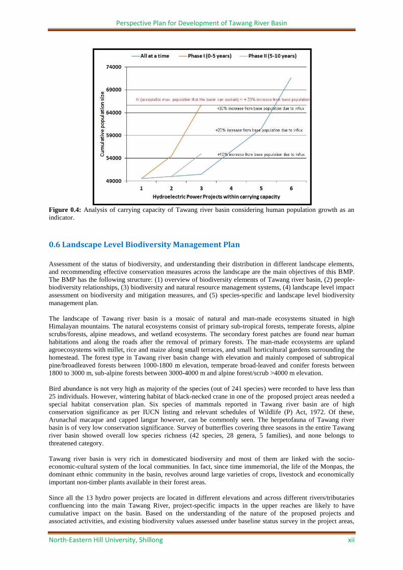
Given the ecological fragility and the resource limitation of Tawang river basin, it will be detrimental to initiate
all the proposed projects at a time. In order to keep the developmental activites within the carrying capacity of
the basin, it is suggested that the projects falling within the carrying capacity limit as depicted in Figure 0.2, viz.
Jaswantgarh, Paikangrong, Nykrangchu, Tawang II, Nyamjangchu, Tawang I, Rho, and Mago Chu may be
taken up in two time phases. For diffusing the impact both spatial and temporal seggregation (Figure 0.3) of the
construction phase is suggested. While phasing several parameters were considered to minimize the impact. For
instance, to maintain the influx of population within the carrying capacity limit, i.e. presumed to be 33%
increase from the base population (Figure 0.4), the phasing resulted in keeping the total population size of
Tawang river basin including the influx within the carrying capacity limit, which far exceeded if all the projects
are taken up together. Thus, the phasing was as follows:
Phase I (0-5 years): Nyukrangchu, Tawang II, Nyamjangchu, Jaswantgarh and Paikangrong
Phase II (5-10 years): Tawang I, Rho, and Mago Chu
Figure 0.3: Spatial seggregation of Phase I and Phase II projects in Tawang river basin.
Perspective Plan for Development of Tawang River Basin
North-Eastern Hill University, Shillong xii
Figure 0.4: Analysis of carrying capacity of Tawang river basin considering human population growth as an
indicator.
0.6 Landscape Level Biodiversity Management Plan
Assessment of the status of biodiversity, and understanding their distribution in different landscape elements,
and recommending effective conservation measures across the landscape are the main objectives of this BMP.
The BMP has the following structure: (1) overview of biodiversity elements of Tawang river basin, (2) people-
biodiversity relationships, (3) biodiversity and natural resource management systems, (4) landscape level impact
assessment on biodiversity and mitigation measures, and (5) species-specific and landscape level biodiversity
management plan.
The landscape of Tawang river basin is a mosaic of natural and man-made ecosystems situated in high
Himalayan mountains. The natural ecosystems consist of primary sub-tropical forests, temperate forests, alpine
scrubs/forests, alpine meadows, and wetland ecosystems. The secondary forest patches are found near human
habitations and along the roads after the removal of primary forests. The man-made ecosystems are upland
agroecosystems with millet, rice and maize along small terraces, and small horticultural gardens surrounding the
homestead. The forest type in Tawang river basin change with elevation and mainly composed of subtropical
pine/broadleaved forests between 1000-1800 m elevation, temperate broad-leaved and conifer forests between
1800 to 3000 m, sub-alpine forests between 3000-4000 m and alpine forest/scrub >4000 m elevation.
Bird abundance is not very high as majority of the species (out of 241 species) were recorded to have less than
25 individuals. However, wintering habitat of black-necked crane in one of the proposed project areas needed a
special habitat conservation plan. Six species of mammals reported in Tawang river basin are of high
conservation significance as per IUCN listing and relevant schedules of Wildlife (P) Act, 1972. Of these,
Arunachal macaque and capped langur however, can be commonly seen. The herpetofauna of Tawang river
basin is of very low conservation significance. Survey of butterflies covering three seasons in the entire Tawang
river basin showed overall low species richness (42 species, 28 genera, 5 families), and none belongs to
threatened category.
Tawang river basin is very rich in domesticated biodiversity and most of them are linked with the socio-
economic-cultural system of the local communities. In fact, since time immemorial, the life of the Monpas, the
dominant ethnic community in the basin, revolves around large varieties of crops, livestock and economically
important non-timber plants available in their forest areas.
Since all the 13 hydro power projects are located in different elevations and across different rivers/tributaries
confluencing into the main Tawang River, project-specific impacts in the upper reaches are likely to have
cumulative impact on the basin. Based on the understanding of the nature of the proposed projects and
associated activities, and existing biodiversity values assessed under baseline status survey in the project areas,

Perspective Plan for Development of Tawang River Basin
North-Eastern Hill University, Shillong xiii
the following possible cumulative impacts have been identified and evaluated for appropriate mitigation
measures and management plans. The socio-cultural-spiritual needs of Monpas were also considered while
developing the mitigation/conservation plan.
A total of 25 impacts of the proposed project activities have been identified at three levels, viz., (i) possible
impacts on ecosystems i.e. on the river, riverine and adjacent terrestrial ecosystems, (ii) possible impacts on the
biological elements i.e. the flora and fauna, and (iii) possible impacts on threatened floral and faunal species,
and mitigation measures for each impact have been suggested. The mitigation plan for impacts on biological
elements and ecosystems include: (1) Development of Natural Resources, and (2) Managerial, Technical and
Legal Interventions. Compensatory afforestation has been proposed to mitigate the loss of forest land.
Mitigation plans for biological, managerial, technical and legal interventions have been proposed for sustaining
ecological processes of the river ecosystem, maintenence of floral and faunal diversity, minimising the impact of
muck dump yards on the river, floral and faunal species, controlling the impact of noise pollution on faunal
groups, avoiding accidental road mortality due to vehicle pressures in the forest areas, and evading biotic
pressures from labour force.
'Ecosystem approach' was considered as the strategy for developing the landscape level biodiversity
management plan for Tawang river basin. Therefore, constituent ecosystems were identified for each landscape
element and ecosystems were used as unit of planning for developing landscape level biodiversity management
plan. Given the (1) wide altitudinal variation in Tawang river basin, and (2) varied landscape elements, the
landscape level biodiversity management plan considered two layers of classification for developing the plan.
Tawang river basin was classified into four climatic zones based on the elevation viz. montane sub-tropical
(1000-1800 m), temperate (1800-3000 m), sub-alpine (3000-4000 m), and alpine (>4000 m). The dominant
landscape elements at each climatic zone were represented by the combinations of different ecosystems such as
forests, scrubland, cropland, wetlands, etc. based on the climatic zone. A landscape level management plan
considering the above mentioned landscape matrix have been formulated with the following salient activities:
Net area of 194,986 hectares need to be established/maintained under the four climatic zones. The identified
activities are: (1) Protection of existing dense forests as community conserved reserves, (2) Creation of 1km
buffer forest on both sides of river/stream, (3) Area under scrubland to be afforested under aided natural
regeneration (below 2500 m asl), (4) Creation of corridors for important wildlife, and (5)
Conservation/rehabilitation of Rhododendron scrubs (above 2500 m asl) (Tables 0.5 and 0.6).
Table 0.5: Biodiversity conservation activities suggested for Tawang river basin landscape
Biodiversity conservation activities Total area to be
maintained (ha)
Existing
cover (ha)
Net area to be
established/
maintained (ha)
Protection of existing dense forests as community conserved reserves (66%
of total geographical area)
143352 80257.68 63094.32
Creation of 1km buffer forest on both sides of river/stream 94280.32 49479.84 44800.48
Area under scrubland to be afforested under aided natural regeneration
(below 2500 m asl)
24641.92 11443.32 13198.6
Creation of corridors for important wildlife 1630.72 435.84 1194.88
Conservation/rehabilitation of Rhododendron scrubs (ha) (above 2500 m asl) 158822.4 86124.96 72697.44
Total 194985.7
Table 0.6: Area prescribed for different biodiversity conservation activities in forest ecosystems across different
climatic zones in Tawang river basin landscape Managing the existing biodiversity Montane sub-
tropical
Temperate Sub-alpine Alpine
Protection of existing dense forests as community conserved reserves (ha) 2642.04 25694.64 35961.12 15598.8
Protection of 1km buffer forest on both sides of river/stream (ha) 2642.04 25694.64 35961.12 7430.76
Protection of existing scrublands on 1km buffer of river/stream (ha) 4027.68 12641.04 23602.32 57337.9
Creation of corridors for important wildlife (ha) 53.76 1040 519.04 27.52
Conservation/rehabilitation of Rhododendron scrubs (ha) NA 12641.04 23602.32 57337.9
The landscape level biodiversity conservation plan has taken into consideration traditional and contemporary
knowledge systems and understanding on biodiversity and its varied elements. The plan has been participatory
in nature ensuring meaningful engagement of local communities and other stakeholders in decision making as
well as implementation of various strategies and actions. The suggested actions are in tune with local socio-
cultural practices and belief systems. The plan recommends for creating an efficient and transparent
organizational mechanisms to coordinate and implement different measures and empowering local institutions

Perspective Plan for Development of Tawang River Basin
North-Eastern Hill University, Shillong xiv
and communities for adopting conservation friendly livelihood practices through capacity building. Following
strategies and measures are suggested for long term biodiversity conservation in Tawang river basin landscape:
Facilitate creation of Biodiversity Management Committees (BMCs) in each Village Panchayat,
Filling the knowledge gap by undertaking comprehensive inventory and status survey of key
taxonomic group; conduct research on structure, function, and interactions amongst and within
ecosystems; monitor the status of ecosystems in the district; documenting traditional knowledge of
community through preparation of People’s Biodiversity Register (PBR); and create a
comprehensive, multi-layered biodiversity data base in GIS domain,
Promoting in-situ conservation efforts through creation and support to Biosphere Reserve; expand
network of Community Conserved Areas; protection measures to Biodiversity Rich Areas in
Influence Zones of Different Projects; conservation and protection of other Biodiversity rich areas;
& conservation and protection of High Altitude Wetlands,
Wildlife Habitat Improvement by regenerating and restoring degraded and open forest and
pasturelands; removal/control of invasive alien species (IAS); fire prevention; and education
awareness,
Regeneration of species of NTFP Values
Establishment of natural resource based value addition facilities for livelihood improvement such
as Citronella, plum, peach, pears, kiwi, pomegrenate, amla, walnut, broom grass, and
Rhododendron flower
Orchid species conservation
Promote conservation friendly agro-pastoral system
Mitigate Human-Wildlife conflicts
Promote biodiversity and nature education/awareness program
Promote infrastructure for eco-tourism development
Support to Existing VFMCs, and
Program implementation mechanism,
The species-specific conservation measures, particularly for the following threatened species/important faunal
groups have been suggested:
Alternate habitat including artificial nest boxes for avi-fauna: Although applicable to all the
recommended project sites, the high abundance of birds in Tawang II project area necessitates to install at
least 1500 nest boxes in the 1 km riverine buffer proposed to be created on both side of the river. Besides, it
is also proposed to create special feeding habitats for birds in 4 to 5 different locations. Each such block
shall be of 2 to 2.5 ha dimension and would provide different habitat types to cater to diverse avifauna. The
existing herbaceous vegetation in all these blocks shall be kept intact and additional planting of 10-15
species of native plants for meeting diverse food needs (insects, fruits, seeds and other vegetable matters)
and nesting sites of avifauna shall be done. Very strong awareness programmes are necessary for the local
villagers and schools in the nearby areas about the ecological role of bird community to enhance the
ecosystem services and the benefits we gain from them.
Protection of wintering habitat of black-necked crane by suggesting the following measures: Considering the conservation importance of the species, the experts were unanimous to protect the habitat
of the species in the downstream area of Nyamjang chu barrage axis. In order to achieve this, e-flow of 10
cumecs during lean season was fixed that would adequately maintain the river flow surrounding the birds’
present habitat. In addition, it was decided that at least 27 Cumecs of water should be made available in the
downstream area during the remaining months of the year to maintain the habitat characteristics. In fact, the
habitat requirement of black necked crane was the deciding factor to determine e-flow in Nyamjangchu
project area. After examining all the possibilities of shifting the barrage axis to an alternate site both in
upstream and downstream areas in a holistic manner, the experts recommend that the existing proposed
barrage site i.e. about 1100 m upstream of the birds’ present wintering habitat be the barrage axis of the
proposed project. The reasons for such decision are: (1) Limited availability of geologically suitable area
both in the upstream and downstream areas of the proposed barrage site, (2) Presence of Gorsham Gompa
and Zimithang township, that would be submerged if the barrage is shifted downstream, (3) Re-alignment
of a long stretch of Lumla- Zimithang road due to possible submergence that would result in destruction of
substantial dense-forested area, (4) Construction of a dam rather a barrage that would destroy several
hectares of high riverine and temperate broad-leaved species-rich forests, and (5) Displacement of villages.
Further, to minimize the disturbance to the birds ‘arrival during October-December, it was recommended
that: (1) No construction activity will be undertaken during these months during construction phase, (2) No
activity beyond 50 m of the barrage axis in the downstream area will be undertaken, (3) No water will be
harvested from the river Taksangchu to maintain the lateral flow in the river. In addition, the project

Perspective Plan for Development of Tawang River Basin
North-Eastern Hill University, Shillong xv
proponents should strictly follow and adopt other mitigation measures as suggested to minimise the impact
of noise pollution (drilling, blasting and tunnelling), water pollution, regulating of vehicle movements and
impacts from of labour force.
Conservation of Arunachal Macaque (Macaca munzala): Though Arunachal macaque was sighted in 9
project areas, due to its endemic and threatened status, the following mitigation and management plans are
suggested: (1) Awareness education programme, (2) Crop protection, (3) Habitat improvement, (4)
Management Oriented Research Programmes, and (5) Wildlife tourism.
Conservation of Red Panda (Ailurus fulgens): Even though, no sighting of red panda occurred during the
study period, its presence in and around the Zemithang project area was confirmed based on the 2 stuffed
animals collected from the riverside. Red panda subsists entirely on plant diet, predominately on higher
altitude bamboo Arundinaria maling. They also feed on berries and fruits of Sorbus cuspidata and Sorbus
microphylla. With understanding of its habitat requirements and existing threats, it is very crucial to adopt
some mitigation measures through management plans as suggested below to protect this threatened species.
(1) Population Status and Assessment, (2) Habitat Protection and Restoration, and (3) Awareness Education
Programme.
Conservation of butterfly species: In Tawang river basin 42 species of butterflies were reported which is
of low species richness and none of the species was under threatened categories of IUCN and IWPA. Even
then, adequate care should be taken to conserve their host plants in the forests.
Conservation of herpetofauna: The reported presence of four threatened reptiles viz., keeled box turtle -
Cuora mouhotii, common mock viper -Psammodynastes pulverulentus, short-nosed vine snake -Ahaetulla
prasina and red-necked keelback - Rhabdophis subminiatus in Tawang river basin indicates the need of
taking conservation measures for this animal group.
Conservation of Capped langur (Trachypithecus pileatus): Capped langur was reported in one project
area (Tawang stage II) with 13 individuals. It is a vulnerable primate species listed in IUCN and also under
the Schedule I of WPA. Because Capped langur is very common across north-eastern states as reported
from 18 protected areas, and due to its capability to use diverse habitats and food plants, the impact of
project activities would be very minimal. Therefore, the mitigation plan as suggested for Arunachal
macaque would also take care of capped langur as well.
Conservation of threatened plants: There are quite a few threatened species of plants in the landscape
which also have high use values for local communities. These species need to be propagated in natural
conditions through assisted natural regeneration efforts. However, in order to achieve the above, following
needs to be done: (1) Standardization for propagation protocols and techniques of different species, (2)
Develop nurseries to raise quality planting materials, (3) Threatened Plant Species Distribution Mapping for
Conservation, (4) Reintroduction of species in minimum 2 ha area of suitable natural habitats, and (5)
Create in-situ germplasm bank. Out of the 10 identified threatened species, adequate distribution records for
4 species could be collected viz. Acer hookeri, Panax bipinnatifidus, Taxus wallichiana, Toricellia tillifolia
etc. The potential area distribution mapping for these 4 threatened species has been made using ecological
niche modeling. These areas are also suitable for reintroduction of the species for their recovery. In
addition, 12 species have been identified that show conservation concern needing further studies concerning
their populations, species biology and regeneration in nature. These species are: Clethra delavayi,
Fritillaria cirrhosa, Picrorhiza kurroa, Rhododendron anthopogon, Bergenia ciliata, Podophyllum
hexandrum, Polygonum verticillatum, Cornus capitata, Botrychium virginianum, Pleione precox, Fraxinus
griffithii, and Schizophragma heterophyllum.
0.7. Development Plan
The planning for hydropower development needs to evolve from a project-based approach to a more holistic one
i.e., an approach incorporating river basin planning and integrating potential social and environmental issues
across multiple projects and the entire river basin. Therefore, adequate and comprehensive planning is attempted
to maximise the positive effects while minimizing the negative or adverse consequences of any development
project. A balanced approach has been proposed for harnessing the hydropower energy and development needs
of Tawang River Basin (TRB) with equal concern for environment as well as the well being of the population.
Thus, the development plan for TRB has been prepared taking an integrated basin development approach to
achieve the agreed vision and objectives through developing basin strategies and detailing the implementation.
Perspective Plan for Development of Tawang River Basin
North-Eastern Hill University, Shillong xvi
Achievement of the objectives would contribute to the socio-economic development and quality of life of the
indigenous people of TRB.
Objectives and scope of the plan
1. To formulate a strategic hydropower integrated development plan of TRB in the context of existing
policies and legislations.
2. To develop a clear-cut action agenda that reflect the aspirations of the people inhabiting the influence
zone of proposed HEP projects in TRB. This should be based on the ground reality relating to current
scenario, the needs and requirements of the people of TRB.
3. To suggest appropriate institutional mechanism for plan implementation.
4. To emphasize the protection of environment and conservation and development of forest and
biodiversity in the face of adverse effects that arise out of HEP implementation
5. To develop mitigation measures and management of disaster risk while also accentuate the need for
preparedness if such event(s) occur
Strategic Process
The development plan was formulated for the development of TRB in 20 years. Because the development plan
was related to HEPs, the scope of the plan was restricted to the influence zones of the 13 proposed HEPs. Thus,
46 villages falling within this zone were covered under the basin plan. The planning process outlined by Pegram
et al. (2013) was adapted for strategizing the plan. Accordingly, the first stage in the process was to conduct the
situation assessment to gain understanding of the current conditions as well as identify and prioritize key issues.
The second stage was formulating the vision and goals to provide the long-term target for TRB development.
The third stage was developing the basin strategies. Four strategic components that form the foundation of TRB
development are:
i. Institutional
ii. Development
iii. Protection, and
iv. Disaster risk.
The fourth stage is detailing the implementation to define actions and give effect to the basin strategy. The
activities as detailed under the four strategic components are as follows:
Institutional: Institutional management system was formulated where in the Tawang River Basin Development
Authority (TRBDA) was proposed to be constituted as an autonomous body by the state government. The
TRBDA will be the implementing agency which would work closely with the HEP project developers and
collaborate with various existing institutions in TRB. In addition to implementing the TRB Development Plan
(TRBDP), the TRBDA will also be entrusted with the responsibility to undertake regular monitoring of
activities so that appropriate iterative and adaptive management can be done.
Development: The socio-economic and infrastructure development system focussed on community
development of TRB. The current baseline scenario under each sector as well as the identified gaps in
infrastructure, human resource and socio-economic requirements/issues, and aspiration of the people were
considered while detailing the actions. The potential impacts that HEP implementation might result is also
outlined under each sector and appropriate measures that the developer need to follow were suggested.
Subsequently, articulate plans/grants and schemes were proposed and specified for the development of each
infrastructure and socio-economic sector. The following R&R scheme and CSR activities were proposed:.
1) Land compensation for acquisition of private land.
2) Compensation towards customary rights over community and USFs
3) School infrastructure development schemes: This includes setting up of schools at project sites,
providing facilities to existing schools in affected and/or influence villages, financial assistance for
computer lab, furniture, library, books and laboratory.
4) Merit scholarship scheme for different education levels (from Primary upto Graduate level)
5) Salary support for teachers and staff to ensure qualified and adequate teaching manpower
6) Training grant for teachers and support staff
7) Exposure tours/visits for school students to technical institutions outside TRB
8) Initiate Worker health program (WHP) and Public health delivery plan (PHDP). For WHP, activities to
be conducted are health education, prevention of diseases, rules and regulations, pre-employment

Perspective Plan for Development of Tawang River Basin
North-Eastern Hill University, Shillong xvii
screening, setting up of health centres at project sites. PHDP involves provision of health service in the
affected and/or influenced villages and setting up of community health care centres and also providing
adequate financial and technical support to the existing government health services such as appointing
specialist doctors in district headquarters hospital and paramedical staff to run the equipments
procured.
9) Road construction and network expansion scheme: This includes providing road connectivity to
affected and/or influenced villages, expansion of road network and access road to important locations
such as agricultural land and farmland as desired by the people by providing RCC bridges and footpath
wherever road is not feasible.
10) Adopt sustainable transport system during construction phase to minimize adverse impacts on forests,
environment and landscape.
11) Power supply scheme and power subsidies: Power supply will be extended to the affected villages
particularly the PAFs. These include 100 units of power free of cost to each family of PAFs every
month for 10 years and an additional 1% from the state governments share of 12% subject to condition
and approval by the state government. The developers will also earmark 1% free power of the project
capacity to local area development i.e. to TRBDA to be utilized for income generation and community
welfare.
12) Water supply and irrigation schemes: Provision of safe drinking water to the affected villages and
PAFs, provision of storage tanks and pipelines to channelize water for irrigation and community use.
Public drinking water facilities and school drinking water facilities.
13) Sanitation and solid waste management plan: Provision of toilet at public locations and especially at
workers camp and construction sites. Toilet to person ratio should not be more than 1:20.
14) Agricultural land compensation: Appropriate and equitable compensation of agricultural land by land-
for-land procedure, employment or financial compensation whichever feasible/desired by the PAFs
15) Agriculture development package: Financial allocation for Jhum land cultivation (if any), agricultural
land preparation grant for newly allotted agricultural land, training assistance for skill upgradation and
technology adoption, provision of polyhouse/greenhouse, supply of QPM (quality planting material),
setting up of Rural Bio-resource Complex (RBC) for value addition.
16) Veterinary assistance: Assist in building manpower at existing Veterinaries, if non-existence, to set up
Veterinaries at appropriate locations.
17) Livestock development: Support for procuring additional livestock, construction of cattle shed and
upgradation of milk storage and processing machineries, provision of feed and fodder to compensate
for affected gazing and pasture land.
18) Grant for craft centres and skill development scheme: Creation/upgradation of existing work shed
including water supply, electricity, tools and machineries, development of training manual, support for
procurement of raw materials etc. Establishment of small paper making unit, small scale food
processing unit.
19) Compensation for horticultural land and horticulture development scheme: Compensate affected
horticultural land, financial assistance for procurement of seedlings.
20) Tourism development grant: Construction of homestay and tourist lodge(s). Improvement and creation
on new trekking trails and camping sites, souvenir shops, restaurants and food stalls etc.
21) Income generation scheme, subsistence grant and control of influx: Provide financial assistance for
diversifying income source, assistance to training for skill development and competency.
22) Electric crematorium: In order to compensate the loss of cremation sites, electric crematorium in all the
affected villages will be provided.
Protection: The resource protection and conservation system is equally important aspect that has been covered
in the development plan. This includes the protection of environment, and forest and biodiversity management
and conservation. The following measures were proposed and recommended.
1) Public awareness programmes: Providing financial assistance for social awareness and support
2) Adoption of strict rules and regulation during construction for protection of local environment
including air, water and soil.
3) Soil and catchment area protection: An appropriate plan has been outlined to check soil erosion and
sedimentation which will be followed during construction phase.
4) Catchment Area Treatment Plan (CAT Plan): CAT Plan will be initiated by all HEP developers and
four key components were generalized and will be followed viz., engineering measures, biological
measures, infrastructure, and monitoring. Maintenance under CAT Plan would be for 3 years after
construction/establishment may be extended whenever required.
5) Other environment management plans that will be taken up by developers include: Muck management
/Disposal Plan, Water, Air quality & Noise Environment Management, Water pollution control plans,
Environmental Management in labour camp, Environmental management in road construction, Control

Perspective Plan for Development of Tawang River Basin
North-Eastern Hill University, Shillong xviii
of Pollution from Labour Camps, Reservoir Rim Treatment &Soil Erosion Control, Maintenance of Air
and Water Quality and Noise Level.
6) Forest and biodiversity conservation: This includes afforestation programmes, habitat improvement and
conservation for avifauna, fisheries, and bottle-necked crane, anti-poaching manpower and
infrastructure. Many more ecosystem/landscape level plans have been suggested in Landscape level
biodiversity management plan.
Disaster risk: The disaster management system involves an area of planning that is focussed on the impacts of
extreme or unplanned events, particularly around the mitigation and management of public safety and property
risks associated with man-made disaster that can occur either relating to or due to hydropower structure and also
with unexpected natural phenomenon. The following events were covered and their mitigation and management
have been proposed.
1) Dam breakage: This includes preventive measure, surveillance and evacuation plan. As such, the
impact of dam breakage in TRB is minimum because all the HEPs except one have proposed barrage
structure and all the villages in the basin are located at least 600m above the river bed.
2) Un-regulated barrage water discharge: Water discharge should be regulated, strong warning systems
should be installed and disaster management cell should be constituted in each HEP project.
3) Earthquake and landslide: Seismic disaster management and safety measures were proposed. Landslide
prevention and mitigation measures were also recommended.
4) GLoF: Nine HEP project sites were found to be vulnerable to GLoF. Effective management and
mitigation plan for GLoF including inter-developer coordination have been proposed. Monitoring,
early warning systems, mitigation and preparedness were outlined.
0.8 Conclusion and Recommendations
Based on the data collected for different components of the study and critical analyses as presented in the
preceding sections, the following recommendations were formulated after several rounds of
brainstorming among the experts.
1) The projects proposed above 2500 m asl would not be implemented in the river basin. Under this criteria, Tsa Chu I, Tsa Chu I Lower, Tsa Chu II, Thingbu Chu and New Melling should not be implemented. However, micro-hydel projects may be allowed subject to fulfilling of other conditions.
2) The projects with the cumulative impact assessment index value >0.84 would not be implemented. Under this criteria, Tsa Chu I, Tsa Chu I Lower, Tsa Chu II, Thingbu Chu and New Melling should not be implemented.
3) The e-flow as recommended in Table I 0.4 should be maintained by all the projects recommended viz. Nykcharong chu, Tawang I, Tawang II, Nyamjang chu, Rho, and Mago Chu. The design discharge,
power generation and peaking hours need to be modified accordingly.
4) The recommended 6 projects and the 2 micro-hydels viz., Nykcharong chu, Tawang I, Tawang II,
Nyamjang chu, Rho, Mago Chu, Jaswantgarh Stage I and Paikangrong should be implemented in two
phases as follows: Phase I (0-5 years): Nykcharong chu, Tawang II, Nyamjang chu, Jaswantgarh and
Paikangrong; and Phase II (5-10 years): Tawang I, Rho, and Mago Chu.
5) The mitigation measures as listed out in Box 0.2 and the details described in Section VII should be
implemented to minimize the adverse impacts of the projects.
The project-specific mitigation measures as detailed below should be implemented: Nykcharong Chu and Rho
1) The construction activities should be planned in such a way that no existing forests and habitats of the
biodiversity are destroyed. If required, the ancillary construction activities may be relocated to save the
old growth forests (e.g., colony site of Rho project).
Tawang-I
1) Adequate care must be taken to save the tourist place e.g. Nuranang Falls from the adverse impacts of
dam construction and also during operational phase.
2) Drinking water sources for all the influenced villages must be ensured.
3) Advanced and appropriate machineries should be used to minimize ground vibrations during
construction phase.

Perspective Plan for Development of Tawang River Basin
North-Eastern Hill University, Shillong xix
Tawang-II
1) The habitats for birds must be protected. The host plant species should be planted under various
afforestation programmes and artificial nest boxes must be installed in sufficient numbers. Although
these measures are common to all the projects, Tawang-II project must make extra efforts in this regard
in view of high abundance of birds.
Nyamjang Chu
1) The design of the barrage should be so adjusted that the pastureland does not come in the submergence
zone. If it is unavoidable, an appropriate land must be procured in consultation with the pastoral
communities of Zimithang village and provided to them. In addition, adequate compensation must be
paid to them to neutralize this impact
2) At least 10 ha of Hippophae rhamnoides must be planted to compensate the loss of Hippophae stand.
3) The proposed diversion of water from Taksang chu is not recommended. Taksang chu should be
allowed to flow freely.
4) A number of villages in the downstream region of proposed Nyamjang chu barrage are dependent on
river for fish, molluscs, prawn and snakes. Therefore, adequate waterflow must be ensured for this
downstream region. Given the amount of water to be released from the barrage, the lateral flow from
18 stream streamlets must be allowed to flow naturally. This would also help in maintaining the
biodiversity in the downstream areas.
5) The project proponent should take several mitigation measures to protect the habitat of the threatened
bird. This should include a wide range of measures ranging from maintaining prescribed e-flow,
restricting the construction activities during winter months and minimising the noise pollution. The
specific recommendations are: (1) Considering the conservation importance of the species, the experts
were unanimous to protect the habitat of the species in the downstream area of Nyamjang chu barrage
axis, (2) In order to achieve this, e-flow of 10 cumecs during lean season was fixed that would
adequately maintain the river flow surrounding the birds’ present habitat. In addition, it was decided
that at least 27 Cumecs of water should be made available in the downstream area during the remaining
months of the year to maintain the habitat characteristics. In fact, the habitat requirement of black
necked crane was the deciding factor to determine e-flow in Nyamjang chu project area, (3) No
construction activity will be undertaken during October-December months during construction phase,
(4) No activity beyond 50 m of the barrage axis in the downstream area will be undertaken, and (5) No
water will be harvested from the river Taksangchu to maintain the lateral flow in the river.
With the above recommendations, Tawang river basin would have the following scenario:
1) The river basin would have at least 66% of its total geographical area under forest cover.
2) At least 50 percent of the main river length should be free-flowing i.e., free from any projects,
3) Being thinly populated, with a total population of around 49000, the influx of population in Tawang
river basin at any given point of time would not exceed 33% of the original local population i.e.
65,000.
4) Minimum level of water should flow in the river round the year to maintain the river ecosystem
structure, function and services, including flora and fauna in river, riverine and the adjacent terrestrial
ecosystems,
5) The seasonal flow dynamics of the river must be maintained, although at a lower scale, to maintain the
river ecosystem function and the adjoining riverine and terrestrial ecosystem functions. This would
ensure the flow of existing ecosystem services, although in reduced scale.
6) All the existing forest/scrub areas should be managed and no more forests should be converted for
other uses,
7) The biodiversity present must be conserved in totality and not a single element of biodiversity should
be lost,
8) The air, water, and noise quality must be maintained well-below the permissible limit as notified by
CPCB,
9) Given the sensitivity and ecological fragility of the ecosystems above 3000 metre elevation in the
Himalayas, no power projects should be undertaken,
10) Religious places or the stretches directly related to the sacred belief of the people must not be
disturbed,
11) No lateral flow or the adjoining ecosystems contributing to the lateral flow in the downstream region of
the barrage should be disturbed,
12) There will be a 1-km wide green corridor on the both sides of the river in the entire stretch of Tawang
river beginning from the first barrage in the upstream region upto Bhutan border in the downstream
area,

Perspective Plan for Development of Tawang River Basin
North-Eastern Hill University, Shillong xx
13) All the well-vegetated forest areas are connected through wildlife corridors for their smooth migration,
14) Establishment of well-designed hydropower projects i.e. design discharge based on actual water availability in a realistic manner, allowing minimum level of e-flow for the downstream river stretch for the sustenance of the river ecosystem, and to ensure the continued dependency of people and wildlife in the downstream area,
15) Forest diversion per capita of power generation must be optimized, 16) Substantial contribution by the power developers towards the socio-economic development of
the river basin, particularly for those people whose lands would be acquired, 17) Soil erosion and other hazards including future uncertainties due to climate change, earthquake
and GLoF must be taken care of, 18) Significant increase in employment opportunities and livelihood diversification. 19) Improved quality of life through need-based intervention in education, health, road network,
sanitation and water supply.
All this would contribute towards realizing the vision set for Tawang river basin in the development plan
i.e. sustainable development of Tawang river basin.