Embed Size (px)
Citation preview
42
P/CI1'11 divcrsit.\" sco/t!d hy t: ro ,t '¡h !()rnt\-a/ong -"¡)ulia/ l/nc! l'lIl'iroJ1ll1eJlIa/ gradit'nl\'
monthly rainfa ll always aboye 100 mm (D ui venvoorden and Lips 1993). Mea n annual temperalure was 25.7°C ( 1980- 1989) (D ui venvoorde n and Lips 1993) .
Field work dala Rectan gular plots of 5 x 50 m were establi shed direc tl y co nti guous lO lhe long side o f previ ously establi shed 20 x 50 m pI OIS. Th ese lalt er pl OlS were insta ll ed in each one o f the above-mentioned land sca pe units, which had been recogni zed 0 11 ae ri a l pholograpils (Du ivenvoorden 2001 ). Dur ing wal ks through the forests, soi Is and terra in forms were rap idl y desc ribed, and lhe fores l was vis ual Jy exam ined. In lhis way, forest sta nds wi lh more 0 1' less homogeneous so il s we re ide ntifi ed. In these stands, plots were loca led wilhoul bi as wilh respect ro nori sti c compos it ion. Recent gaps due to fa ll en ca nopy trees were avo ided. AII plots we re establi shed in rn alure fa rests that did nol show s igns o l' recent human in lerve nl ion, at a minirnum di stance of 500 m belween plots (F ig. 3.1). PI OIS were mapped wi til GPS. In 1997 and 1998, lhe density and spec ies compositi on of li anas and trees wirh DBH ::: 2.5 cm were recorded in these O.I-ha pl ots (Duque el a/. 200 1). During a new field work from March lo June 2000, the adj acent 0.025-ha plots were censused fa r epiphyti sm. The 5 x 50 m pl ots we re subdivided inlo subplots of 5 x 10m, in which a ll vasc ul ar epi phytes occurring on trees and lianas with a stem bas is insi de the pl ot area we re recorded.
FieJd co ll ection ol' epiph ytes was done with the help of indi ge nous climbers. Binocul ars were used to examine epi phyte individuals occurring in di slanl crowns. Wilh the help of poles, crowns were surveyed and a ll observed individ ua l ep iphyte plants were co ll ected. For eac h epiph yte planl , lhe pos it ion above grollnd (in the case of hel1li-ep iphytes the maximum heighl was consid ered), and pos ition on lhe phoroph yte (main stem 0 1' branches) we re reco rd ed. Three plant pos itions were con sidered: ( 1) base indi viduals found al 0 1' be low 3 11l aboye ground leve l; (2) stem: ind iv iduals fo und above 3 m and be low til e firs t branch; (3) branches 0 1'
crowns: indi viduals fou nd on slems 0 1' branches in crowns.
For each phorophyte, the fo llow ing variab les were reco rd ed: ( 1) DBH (from phoroph ytes wilh height lower than 1.3 m the slem diameter was recorded al hal f of the total heigil l) . (2) Tota l height and height ol' fi rst branch, measured or est imated by means of po les of 8 meters lenglh . For lrees, we ca lcul ated the conica l superfi cial area of the phorophyte stems as 3. 14 times the prod ll cl 01' the stem radius and the height of rhe ti rsl bra nch (i f there were no branches, the to ta l hei ght was employed). AII species in each plot were co llected appl ying vo uchers num bered AMB 100J 300. Species id entif'ica ti on too k place al the Herba rio Universidad de Antioq lli a (HUA ), Herbario Arnazónico Colombiano (COA H), and Herbari o Nacional Colombiano (COL), by means 01' taxonomi c keys, compari son wi lh herbari ll m coll ect ions, and consul ta ti ons 01' spec ia li sts. The nomenclat ure of fa milies fo ll ows Cron qu is t ( 1988) fo r angiosperms and Tryon and Tryo n ( 1982) for pteri dophytes. Wi thin fa milies 0 1' groups of closely alli ed fa lllilies, speci mell s that could not be identifi ed as spec ies beca use o l' a lack of suffíc ienl di agnosti c characterist ics , were clll stered into morpho-spec ies on lhe bas is 01' simul taneous morpho logica l comparisons with a ll other spec imens.
A/¡'sl (jlf{ll1Iilali\'(~ census (~r\l(I\T/(IUI· cjJlph.\..'les il1l"Cún/ore.,·'s (~j"Co/()mh;(¡n Amazonia
In this study, the terlll epiphyte is used, in a broad sense, for plants that spend most of their life cycle attached to other plants (Benzing 1987), including true epiphytes (holo-epiphytes) and hemi-epiphytes. Only those epiphyte individuals that were in contact with the forest so il were recorded as hemi-epiphyte. Clones from rhi zomatous plants were considered as one individual.
NlIl11erica/ al7a/¡'sis To calculate the diversity, Fisher' s alpha index was employed (Fisher el al. 1943, Condit el a/. J 996). Differcnces of diversity , speci es richness, epiphyte abundance, and superficial area ol' the phorophytes between th e landscapes were analyzed by ANOV A and subsequent Tukey-Kramer tests. The condition of normal distribution of residuals was chec ked by means of Shapiro-Wilk tests. The analyses were deveJoped using JMP 3.2.2 (SAS 1994).
Patterns of epiphyte spec les composition were expJored by Detrended Correspondence Analysis (DCA, Hill 1979) in CANOCO version 4 (ter Braak and Smilauer 1998), applying plot data ofabundance and presence-absence. Correlations between epiphyte species, trees and liana species in the adjacent plots, and the spatial position of the plots, were analyzcd by Mantel and partial Mantel tests (Legendre and Legendre 1998), applying R-package for Macintosh (Casgrain and Legendre 2002). The floristic silllilarity matrices were constructed on the basis of the abundance data using the SteinhallS indexo A Euclidean distance matrix was calculated using the geographical coordinates of the plots (Legendre and Legendre 1998). The significance of lhe Mantel r coefficient was tesled by means or' 10000 permutations.
4.3 RESULTS
A total of6129 individual vasclllarepiphytes were recorded in the 30 plots ofO.025 ha each. Precise ly J200 botanical collections were made pertaining to 27 famili es , 74 genera , and 213 species (which included 59 morpho-spec ies) . A total of 141 species (66%) were found in more than one plot and just 17 species (8%) represented 50% of lhe total nllmber of individuals regi stered. Many species (78) were found both as hemi-epiphyte and holo-epiphyte. Most species (107) , however, were strictly holo-epiphytic , while 28 species were always hemi-epiphytic.
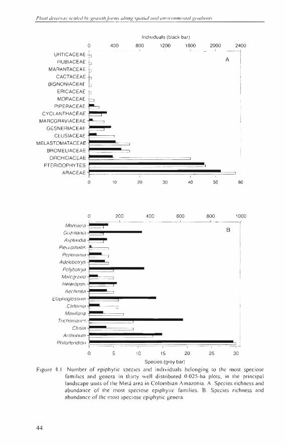
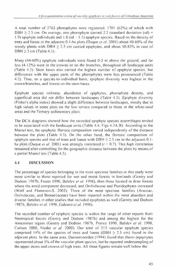
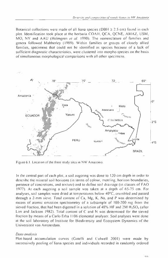
Araceae, Orchidaceae, and Bromeliaceae were lh e most speciose and abllndant families (see Appendix 3 and Figure 4.1 A). Of these, Araceae was the most diverse famiJy in all landscape units. Two genera of Araceae, Philodendl'Ol7 and Anlhllriul11 , had the highest species richness (Figure 4.1 B). There were J 17 monoco tyledonous species (5 famili es , 36 genera), 45 species of pteridophytes (12 families , 20 genera) , and 49 dicotyledonous species (10 families , 18 genera). Five species were found in all landscape units: Aechl11ea nivea (Bromeliaceae), Asp /eniul11 serralul11
(Aspleniaceae), Codonanlhe cra.l'sijó/ia (Gesneriaceae), Anlhllrilll11 emesli; (Araceae), and Phi/odendl'Ol1 /il1l1oci (Araceae). TrichOl11anes ankers i i
(Hymenophyllaceae) was the most abundant species , being present mainly in upland fores ts .
43
Plan! divers i /I'scaled by gr{) ,,·!hjimll.\ (don,\; sPillial "lid enI'llDnm(' lI!ul gmdien!s
BIGNON IACEAE
ERICACEAE
o
PIPERAC EA
CYCLANTHACEA
MARCGRAVIACEA E
GESNERIACEAE F4
400
Indlviduals (black bar)
800 1200 1600 2000 2400
A
ORCHIDACEAEI.~~~~= PTERIDOPHYTES I ARACEAE .
Monslera
Gl/zmal1ln
A~pllll ldla
Plel110117allis
Peperomia
Adelobollys
Polybolrya
Marcglavia
Heleropsis
Aec/lmea
H"IplIOglosSUlII
Clidemia
Maxil/ana
Tricho/llal/I's
Clusia
AllIl luriurn
PllilorJelldr017
o
o
~
S---i.....
-_. -o
10 20
20 0
i i
5 10
30 40 50 60
400 600 800 1000
B
I i i
15 20 25 30
Species (grey bar)
Figure 4. 1. Number of epiphytic species and indi vidua ls belo ngin g lO the Illost speciose families and genera in thiny well di slri buted 0.025-ha pI01S, in lhe principal landsca pe units of the Melá area in Colombi an Amazonia. A. Speci es ri chness and abu nd ance of lhe mosl speciose ep iph yli c lami li es . B. Species ric hness and abundance of lh e 1ll 0s1 speciose epiphyli c ge nera .
44
A{trs! q//On!ilolive c e nSIlS of vasclllar elJ/jJhl'les in ruin/ore.I·!.\' ofColombion Amazonia
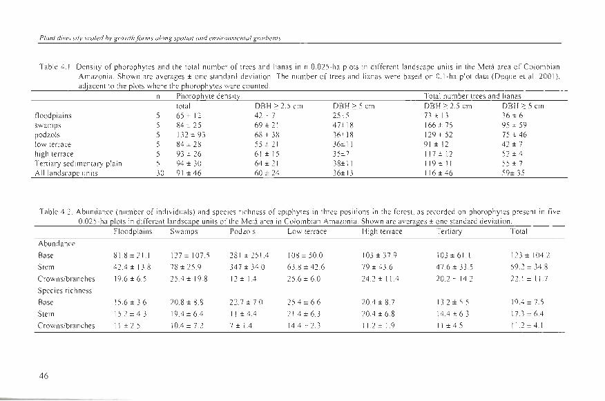
A to tal number of 2763 phoroph ytes were reg is tered, 1701 (62%) of which with DBH ~ 2 .5 cm. On average , one phorophyte carried 2.2 (standard deviation (sd) =
1.9) ep iphyte individuals and 1.8 (sd = 1.2) epiphyle species . Based on the dens ity of trees and li anas in the adjacent O.I-ha plots (Duque el al. 200 1) about 40-60% of the woody plants with DBH ~ 2.5 cm ca rri ed epiphytes, and about 50-85% in case of DBH ~ 5 cm (Tab le 4.1).
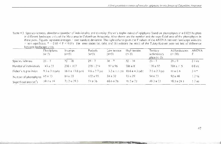
Many (44-60%) epiphyle indi vi du a ls were fOllnd 0-3 m aboye the g round, and far le ss (4 -1 2%) were in Ihe crowns or on th e branches, throu ghout all landscape units (Table 4 .2). Stem bases a lso carried the hi ghest number of epiphyte species, but diffe rences with the upper parts of th e phorophytes were less pronounced (Table 4 .2) . Thus , on a species-to-individual basis, epiphyte di ve rs ity was hi ghes t in the crown/ branches, and lowest on th e stem bases.
Epiphyte spec ies richness , abunda nce of ep iph ytes, phorophyte density, and superfi c ia l area did not differ between land scapes (Table 4.3). Epiphyte divers ity (Fisher's a lph a index) showed a s li ght difference between landscapes, mos tl y due to high va lues in some plots on th e low terrace compared to those in the white-sand a reas and th e Terti ary sedimentary plain.
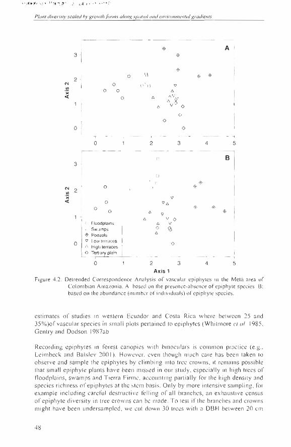
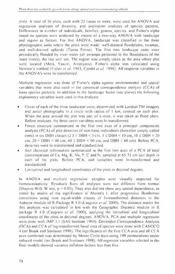
The DCA d iagrams showed how lhe record ed epiphyte species asse mblages tended lo be associated with the land scape units (Table 4.4 , Figs 4.2A ,B). According lO the Mante l test, lhe epiphyti c fl ori s tic composition varied independentl y of the distance between the plots (Table 4 .5) . On th e other hand , lhe f1 0 ri s ti c com pos ition of ep iph yte spec ies and th al of trees and li anas with DBH ~ 2.5 cm in the adjacent 0.1ha plots (Duque el a/. 200 1) was strong ly correlated (r = 0 .7). Thi s hi gh corre la ti on remained alter controlling for the geograp hi c di stance belween th e plots by mea ns of a parti a l Mante l test (Table 4 .5) .
4.4 DISCUSSION
The percentage ofspecies belongin g lO the most speciose families in this s tudy were more s imilar lo tbose reported for wet and moist forests in lowl ands (Gentry and Dodson 1987b, Foster 1990, Bal s lev el a /. 1998), than those loca ted in drier forests where th e a ro id component decreased, and Orchidaceae and Pteridophytes increased (Wolf and Flamenco-S. 2003) . Three of th e most spec iose fa mili es (A raceae , Orchidaceae, and Bromeliaceae) llave been reported within th e most abu ndant and diverse fam ilies in other studi es th at inc lllded epiphytes as well (Gentry and Dodson 1987b, Balslev el a /. 1998 , Galeano el a/. 1998) .
The reco rded number of ep iphyle species is within the range of o th er reports from Neotropical forests (Gentry and Dod son 1987 b) and among th e hig hest for the Amazon ian reg ion (Gentry and Dodson 1987b, Prance 1990, Balslev el a/. 1998 , Carlsen 2000, N jeder e l a/. 2000). Our total of 213 vascular epjphyte spec jes compri sed 14% of th e spec ies of trees and lianas (DBH ~ 2.5 cm) fo und in the adjacent plots. In th e same area , Dui ve nvoorden ( 1994) found that (hemi- )ep ip hytes represented about 5% of the vascular plant spec ies, but he reported undersa mpling of th e upper s tems and crowns o l' hi gh trees. AIJ these t~ gures remain well below th e
45
Plonf diversi(v scoled by grolVfh forms olong spofiol olld ellvirol1tnell/Ol grodiellls
Table 4.1. Density of phorophytes and the total number of trees and lianas in n 0.025-ha plots in different landscape units in the Metá area of Colombian Amazonia. Shown are averages ± one standard devialion. The number of trees and lianas were based on O.I-ha plot data (Duque et al. 2001), adjacenl 10 the plots \-vhere the phorophytes were counted.
n Phorophyte density Total number trees and lianas total DBH ~ 2.5 cm DBH ~ 5 cm DBH ~ 2.5 cm DBH ~ 5 cm
floodplains 5 65 ± 12 42 :!o. 7 25,,- -" 73 ± 13 36 ± 6 swamps 5 84 ± 25 69 ± 21 47.U 8 166 ± 75 95 ± 59 podzols 5 132 ± 93 68 ± 38 36± 18 129±52 75±46 low terrace 5 84 ± 28 55 == 21 36±11 91 ± 12 42 ± 7 high terrace 5 93 :i 26 61 ± 15 35",7 117 ± 12 52 ± 4
Tertiary sedimentary plain 5 94 ± 30 64 ± 21 38±11 119 :!: 11 55 ± 7 AII landscape units 30 91 ± 46 60 ± 24 36±13 116 ± 46 59± 35
Table 4.2. Abundance (number of indi viduals) and species richness of epiphytes in three positions in the forest , as recorded on phorophytes present in ¡¡ve 0.025-ha plots in different landscape unilS of lhe Melá area in Colombian Amazonia. Shown are averages ± one standard de viation.
Floodplains Swamps Podzols Low lerrace High terrace Tertiary Total
Abundance
Base 81.8±21 .1 127 ± 107 .5 281 ± 251A 108 ± 50.0 103 ± 37.9 103±61.1 123 ± 104 .2
Stem 42A ± 13.8 78 ± 25 .9 347±34.0 63.8 ± 42.6 79 ± 43.6 47.6 ± 33.5 59.2 ± 34.8
Crownslbranches 19.6 ± 6.5 25A ± 19.8 12 ± lA 25.6 ± 6.0 24.2 ± IIA 20.2 ± 14 .2 22.1 ± 11.7
Species richness
Base 156±3.6 20. 8 ± 8.8 22.7±7.0 25A ± 6.6 20A ± 8.7 13 .2 ± 5.5 19A ± 7.5
Stem 15.2 ± 4.3 19A±6A 11 ± 4.4 2IA±6.3 20A ± 6.8 14.4 ± 6.3 17.3 ± 6.4
Crownslbranches 11 ± 2.5 10.4±7.2 7±1.4 14A '" 2.3 11.2 ± 1.9 11 ± 4.5 112 ± 4.1
46
- ---
A jinl q/lCll1l ilOli"e census of vascu/a!" epiphy/es in rain f ores /s of C%mbian Amazonia
Table 4.3. Species richness, abundance (number of individuals), and diversity (Fi sher' s Alpha index) of epiphytes found on phorophytes in n 0.025-ha plots in di1'fe rent landscape units 01' the Metá area in Colombian Ama zoni a. Al so shown are the number and the su perficial area of th e phorophyte s in ¡hese pl ots. Fi gures represent averages ± one standard de vi ati on. The ri ght co lumn gives the F va lues of the ANOVA between landscape units (ns = non significant ; * = 0.05 < P < 0.01 ) The letter codes (a ). (ab), and (b) indicate the result 01' the Tukey-Kramer post-hoc test of difference between landscape units.
Flood plains S\\'amps POdLOls Low terrace High ten'ace Teniary A11 landscapes ANOVA (n=5) (n=5) (n= 5) (n=5) (n=5 ) sed im entary (n=30) F
I2lain (n=5) Species richness 25 cz 7 32 :t: 10 29 := 7 36 ~ 7 32 -:: 10 23 ± 7 29 ± 9 2. 1 ns
Number of indi viduals 143 ± 33 230 ± 107 278 ± 214 197 ± 96 206 ± 81 170 ± 92 204 ± 115 0.8 ns
Fi sher' s Alpha index 93 ± 3. 1 (ab ) 16.1 ± 13.8 (a b) 9.6 ± 2.7 (a) 13.2 ± 1.1 (b ) 10.6 ± 4.3 (ab) 7. 6 ± 2.3 (a) 11 ± 6.4 3.4 •
N umber 01' phorophytes 65 ± 13 84 ± 28 \ 32 ± 93 84 ± 32 93 ± 29 94 ± 33 92 ± 46 1.2 ns
Superfici al area (m 2) 59. 7 ± 19 71.2 ± 29 .3 57 ± 26 68 .6 ± 26 76.2 ± 22 R9 .3 ± 23 70.3 ± 24 .1 1.2 ns
47
.' .:.: ..... )t'r .~ : \ }I':1 ~.;t'· ,-l' ~"l.' , • . ~ I!' · ;'
Planl divasil)' scaled hy grO ll'lhfórll1s alollg .I'¡Jol /(J1 (111<1 CI1I ,j¡ 'O/1/lIef/lol gl'Odienls
3 i 0
0 A
O fd 0
0 0
N
.!!1 ><ex:
2 '1
1 -'
O
o O
O
dJ 11
e,
"
<;J
e,
11" e, ) v' O
O
°L O
O
-r-
2
O
3 4 5
n B
3 1 o
00 0 O <i>N (1 U
VI 2 I>< v
ex: O ve, O <i> 0
O e, <i> <;J
e, v O e tlOodPr';;;;;-l e,
r SWfll11ps o <2> " e,<1> POdLOls
O ·1 <;J 1ow ter'3ees I o e, Hlgl1 terraees
O Tert'ilIY plain , O 2 3 4 5
Axis 1
Figure 4.2. Detr'enclecl Correspondcnce Ana lysis 01' vasc lIl <tr epiphyLcs in rhe MelR an:,a or Co lombinn Amazonia. A: based 0 11 lhe presencc-ahscnce of epiphylC spec ies. 8: basecl on lhe abundance (nulllber of indi viduab) 01' epi phyle spec ies.
estimates oC studi es in wes lern Ecuae!or and Cos la Ri ca whe re belween 25 and 35%)of vascul ar spec ies in small plOIS perlain ee! lO epiph y tes (WhilrnOre el a/. 1985. Genlry ane! Dodson 1987ab
Recore!in g cpiphytes in ro res l canopies w ith binoc ul ars is com lllon pracl ice (e .g. Leimbeck an e! Bals lev 200 1) . Howevcr. cven lhough Illllch care has been laken 10
observe ane! sa mpl e l he epiphy les by cli mb ing inlo lree crowns. il remain s possib le Ihat small ep iph y le planls have bee ll mi ssee! in our slucl y. especially in high trees 01' tlooe!plai ns, swamps ane! Tierra Firmc. accou nling parl ia lly 10 1' Ihe high densily ane! spec ies r ich ness 01' ep iphy tes at lhe slcm basis. O nly by more inlensi ve sampl ing. rol' example including ca rerul e!estrucli ve felling 01' all branchcs. an ex hauslive ce nsus o l' epiphyle e!i ve rsily in Irce erow ns can bc made. To les l ir Ihe branches and crow ns might ha ve been une!ersa mplee! . we cul dowll JO Irces w ith a DBH belween 20 cm
48
A //1 SI quanlilalil'e (;(,I1SII.\ n( vl/scular e¡¡iph.l"es il1 min(ou:.\·IS o/Colomhian Amazonia
and 30 cm well outside the plot areas but close to each plor. Each of these trees had a vi sually defined large epiphyte load along the stem and in the crown. Contrary to our expec tations, the analyses of these data , whi ch are slill in a preliminary stage of species id entifi ca tion and lherefore not shown here, did not reveal s ignificant differences in the number of epiphyle individual s and epiphyte species in branches and crowns compared to the phorophytes in similar diameter-class sampled in the plots
Table 4.4 . Su mm ary information 01' Delrended Correspondence Analyses (DCA), based on vascular epiphyle species composition on phorophytes in thil1y 0.025-ha plots.
Axis 1 Axi s 2 Axis 3 Axis 4 Total inertia
A: Presence-absence data
Eigenvalues
Length 01' grad ient (sd units)
B: Abundance data
0.45
4. 1
0.28
3.3
0.17
VI
0. 12
2.2
4.23
Eigenva lues
Length oC gradi ent (sd units)
0.54
4.7
0.27
3.2
0.16
2.3
0.12
1.9
4.78
About 4 to 6 out of every 10 woody plants (OBH ::. 2.5 cm) and 5 to 8 out of every 10 woody planl with DBH ::. 5 cm carried epiphytes, suggesting that epiphytes fail to effectively colonize a substantial number of potential phorophytes in the Metá area. Leimbeck and Balslev (200 1), in tloodplains of nea rby Yasuní , found that 98% of the trees with DBH _ 5 cm carried aroid epiphytes. These authors hypothes ized that aroid epiphyles ex perienced limitation for phorophyles in tloodplains. Their floodplain saturation percentage of 98% corresponded to about 25 phorophytes with aroid epiphytes per 0.025 ha when based on the tree density (OBH ::. 5 cm) of 10 12/ha reported by these authors. In the five Iloodplain plots of the Metá area, the average number of phorophytes with aroid epiphytes was 21/0.025 ha , corresponding to 58% of the trees and lianas witil OBH ::. 5 cm. So, on a plot area basis, the foresls of the floodplain of the Caquelá River contained 16% less phorophytes covered with aroid epiphytes, and lheir phorophyte sa turation level for aroids was about 40% lower than in Yasuní. It seems unlikely, in thi s li ght, that the aroid epiphytes in the Metá experience phorophyte limilation to the same degree as might take place in Yasuní floodpl ai ns. For the trans ition and upland areas in Yasuní , about 3 1 and 32 phoroph ytes wilh aroids were found in sample areas of 0.025 ha , whi ch corresponded lo 82-86% of the total tree density (OBH ~ 5 cm). In the three Tierra Firme units thi s average number ranged between 14/0.025 ha and 29/0.025 ha , corresponding to 26-70% of lhe lree and liana dens ity (OBH ~ 5 cm). This comparison suggests that a lower number of trees and lian as are covered by aroid epiphytes in upland forest s ofthe Metá area compared to Yasuní, and that tbe saturation leve l and phorophytelimilation is comparatively low too, just as in the tloodplains. Overall climate and humidily levels of the Yasuní area and Metá areas hardly differ (Lips and Ouivenvoorden 200 1) . Yasuní forests might be subjected to a grea ter immigralion of aroid epiphytes from the surrounding forests, espec ially from
49
50
Planl diversily scaled by growlh forms along spalial and environmeJ1lal gradienls
the nearby Andes , compared to the Caquetá area. The Andes have been mentioned as a rich centre of diversity for aroid epiphytes (Gentry 1982).
Table 4.5. Mantel and partial Mantel test results ofvascular epiphyte species against species of trees and lianas, and geographic distance (s pace) in the Metá area of Colombian Amazonia. Matrix A is composed of Steinhaus similarity coefficients between epiphytic species data from thirty 0.025-ha plots. Trees is the matrix composed of Steinhaus similarity coefficients between species data oftrees and lianas (DBH:::: 2.5 cm) from thirty 0.1ha plots, each directly adjacent to the 0.025-ha plots where epiphytes were recorded. Space is the matrix composed of Euclidean distances between plots. Mantel r is the Mantel correlation coefficient between matrix A and matrix B. Partial Mantel r is the Mantel correlation between matrix A and matrix B when the effect of matrix C is removed.
Mantel r Partíal Mantel r Probabílíty Matríx A = AII vascular epiphylic specíes Matrix B Trees 0.7 0.0001 Space - 0.05 0.18 Matrix B Matrix e Trees Space 0.7 0.0001 SEace Trees -0.02 0.33
In the Metá area, epiphytes showed a more or less similar abundance and species diversity in all landscapes. This is remarkably different from trees, which show a well-documented gradient in species diversity from swamps and podzols to well drained floodplains and well-drained uplands (Duivenvoorden 1996; Duque et al 2001). Why might landscape factors not affect epiphyte diversity in the same way as they do for trees? Epiphytes in upper canopies in all lowland forests are generally subjected to high temperatures and low levels of air humidity (ter Steege and Cornelissen 1989), leading to energetic losses by tissue respiration and water balance stress (Andrade and Nobel 1997; Zotz and Andrade 1997). In forest understories stress factors differ between forest types. In the understory of tall forests, air humidity tends to be higher and more constant but light availability and associated rates of carbon fixation lower (Kessler 2002). In the understory of low forests, light penetration in understory is higher, but temperature and drought are also higher leading to less favorable growth conditions for epiphytes. Therefore, the epiphytes in both high and low forests in the various landscape units might experience a more or less similar net degree of stress. Secondly, epiphytes are c1aimed to have a high dispersal ability (Benzing 1987; Nieder el al. 1999), which would allow a more rapid colonization reducing possible effects of forest development on epiphyte species diversity. This explanation, however, seems only valid for epiphytes occuring in upper canopy crowns, but not for understory environments where dispersal by wind is less effective. A high epiphyte dispersal ability should lead to a wide distribution of many epiphyte species in all landscapes, which is not in correspondence to the high epiphyte-Iandscape association recorded in the Metá area.
A Jirsl quanlilalive census ofvascular epiphVles in m in fo res ls o( Colombian Amazonia
Epiphyte species compositional patterns were well related to the principal Jandscape units (Figs 4.3AB and Table 4.4). In view of the dominance of epiphytes in the understory this is hardly a surprise. The floodplain and swamp plots are subjected to an annual inundation by the Caquetá River, during which water levels may rise several meters aboye the forest soil. This, plus the c10ser proximity of river and swamp water during periods of low river water levels likely produce a higher humidity (including mist in early mornings), at annual and daily time-scale , compared to upland conditions. Yearly sedimentation of silty deposits , which are partially of Andean origin , makes the rooting environment at the trunk bases more ferti le than in upland forests. Leimbeck and Balslev (200 1) further mentioned enhanced vegetation reproduction due to mechanical damage or separation of plant parts into ramets when submerged. The lower stand height and simpler structure of white-sand forests might induce less habitat diversity , as well as better light penetration and wider daily amplitude in temperature and humidity in the llnderstory environment, compared to the generally taller forests in the other landscape units.
Contrary to trees, landscape parterns of species diversity and species composition for epiphytes are uncoupled. In concJusion, we hypothesize that some epiphyte species are more favoured by high humidity (floodplains and swamps), or are better adapted to withstand drought (in low podzol forests) than others without leading to competitive exclusion as this latter process is effectively counterbalanced by immigration from regional pools in situations of Jow phorophyte limitation. We need more explorative stlldies, and additional studies on the dispersal ability and alltobiology of epiphytic taxa and the dynamics of epiphyte populations (Benzing 1995; Nieder and Zotz 1998). Our reslllts suggest that caution is needed when knowledge of tree species distriblltion and dynamics are extrapolated to growth forms with a totally different ecology and vice versa.
5 J
Chapter 5
FERNS AND MELASTOMATACEAE AS INDICATORS OF VASCULAR PLANT COMPOSITION IN RAIN FORESTS OF
COLOMBIA N AMAZONIA
Alvaro J. Duque M., Joost F. Duivenvoorden, Jaime Cavelier, Mauricio Sánchez, Carolina Polanía and Andrea León
Submitted to Plan! Ecology
5.1
Ferns and melas lOmalaceoe as indicalors 01 vasculo/' planl composilion
INTRODUCTION
Ecological indicators can be defined as a discrete expression or portion of the environment that provides quantitative information on ecological resources reflecting the status of large systems (Hunsaker and Carpenter 1990). Organisms may be employed to test conditions of resources or exposure of biological components to stress. For instance, invertebrates or lichens have been used as indicators for forest degradation (Rodríguez el al. 1998, Clarke and Grosse 1999) and water quality (EPA 2003). Ferns and Melastomataceae ha ve be en used as indicators of patterns of tree species distribution at different spatiaJ scales (Ruokolainen el al. 1997, Vormisto el al. 2000) . How subsets of understory plants might provide information about patterns of other vascular plant taxa in tropical forests has, however, never been examined in detail. Plot record s of vascular tloristic composition, including large canopy lrees, herbs, shrubs, and small trees are still scarce (Gentry and Dodson 1987, Duivenvoorden 1994, Balslev el al. 1998, Galeano el al. 1998).
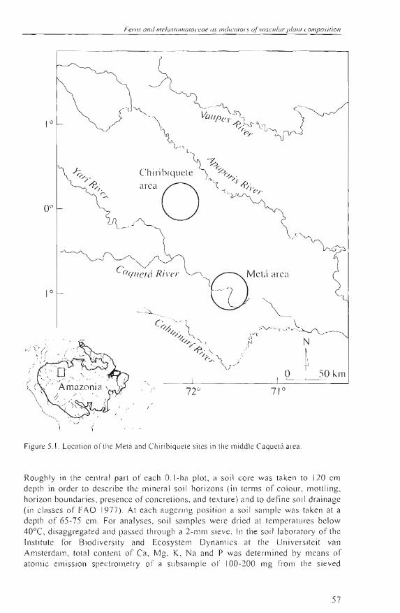
Recently, a new sel of near-lotal vascular plant species composition in a series of widely distributed small plots in Colombian Amazonia has become available (Fig. 5.1). The aim of this case-study is to use these data 10 examine lo which degree species information from ferns and Melastomataceae might explain Ihe composition of the other vascular plant species in these plots. In general, ferns and Melastomataceae may intluence the settlemenl and growth of other forest plants in a direct way (for example, analogous to the well-known allelopathy of Pleridium aqui/inum (L.) Kuhn in temperate forests), or they may cOrTelate to other forest plants by chance, or because of a common response to external factors (e .g. flooding, topography, etc.). Previous work suggests that ferns and Melastomataceae in NW Amazonian foresls are associated with soils, topography , and physiographic units or laodscapes (e.g. Tuomisto el al. 2003). As these same factors, including space, have also been significantly related to patterns 01' tropical tree composition (Phillips el al. 2003), we expected to find a correlation of ferns and Melastomataceae with the other plant taxa found in the forests . Canonical analysis was appJied to regress vascular plant species composition in the forests against information from these two indicator groups, together with that from soiJs, landscape, and lhe spatial salllpling designo We focused on two questions: 1) Are the main patterns in rorest plant composition, as extracted by the principal ordination axes, better related to ferns and Melastomataceae than the soil chemical properties, spatial location of the sample plots or the overall effect 01' the main landscape? 2) Do ferns and Melastomataceae explain any part 01' the total variation in forest plant composition after having accounted for effects 01' space, soi Is, or landscape? The first question addresses the practical indicator potential of ferns and Melastomataceae, relative to the other types of information that are frequently obtained in reconnaissance inventories . The second question may falsify the hypothesis that ferns and Melastomataceae are silllply related to the composition of other forest plants beca use 01' a common response to soils 01' the main landscape.
55
5.2
56
Planl diversily scaled by gro\vlh/onns along spalial and environ/IJenlal grodienls
METHODS
Sludy sile The study area covers about 2000 km 2 and is situaled along lhe Slretches of the middl.e Caquetá and Mesay Rivers in Colombian Amazonia, roughly between 72° 37' and 71 o 18' W longilude, and O o 55' S and O o 9' N latitude (Fig. 5.1). The principal landscape unit s found here are well-drained floodplains, swampy areas (including penllanently inundated backswamps and basins in floodplains or fluvial terraces), areas covered wilh white-sand so il s (found on high terraces of lhe Caquetá River and in less dis sec ted parts ofthe Terliary sedimentary plain), and Tierra Firme (which are never flooded by river water and include low and high fluvial terraces and a Tertiary sed imentary plain) (Duivenvoorden and Lips 1995, Lips and Duivenvoorden 1996). Soils and landscape units are called well-drained when soil drainage (according to FAO 1977) is imperfectly lo well-drained (FAO drainage class ~ 2), and poorly drained when soils are poorly to very poorly drained (FAO drainage class < 2). The area receives a mean annual precipitation of about 3060 mm (1979-1990) and monthly rainfall is never below 100 mm (Duivenvoorden and Lips 1995). Mean annual temperature is 25.7°C (1980-1989) (Duivenvoorden and Lips 1995).
Field and laboralory work We conducted a survey of 40 O.I-ha plots lhat were localed in the four landscape units mentioned above. In order to eslab lish the plots, starting locations along the Caquetá , Mesay, and Cuñare rivers and the direction of the tracks along which the forests were entered, were pl anned on the basis of the interpretation of aerial photographs and salellite images (Duivenvoorden el al. 200 1). The topography was rap idly described and the forest was vi sually exami ned in order to identify more or less homogeneous terrain units. In these units, rectan gu lar plots were located without bias wilh respect to floristic composit ion or I'orest st ructure, and were delimiled by com pass, tape and stakes, starting at a random poin!. Al! plots were mapped by GPS and were estab li shed in mature forests that did not show signs of recent human intervention, at a minimum distance from eac h other of 500 m. ln each plor all vascular planls Wilh DBH ~ 2.5 cm (DBH diallleter al breas t height) were described, counted and co llected. Thirly ol' these plots were located in the Metá area (Duq ue el 01. 2001. 2002). Here, a subplo t o f 0.025 ha (5 x 50 m) was esta bl ished direct ly bordering each plot , in order to coun l and collect all herbs as well as all ot her vascular plants 01' height > 1 111 (and DBH <2.5 cm). Ten other O.I-ha plots were established in lhe Chiribiquete area. There, the 0.025 ha subplots were Joca ted inside instead 01' just outside lhe O.I-ha plots. Fieldwork took place from April to December in 1997, and frol11 March to November in 2001.
The identification of the botanica l colleclions took place at the herbari a COAH, CO L, HUA. MO , and AAU (Holmgren el 01. 1990). Within families or groups of closely allied families, specimens that could not be idenlified as species beca use ofa lack of sufficienl diagnoslic characleristics we re clustered into morpho-species on the basis of simu lwneous morphological comparisons witb a ll olher spec imens. Hereafter lhe lcrlll spec ies refers lo both Illorpho-species and bolanical species.
Ferns 0",1 meloslu/11o loceol' as 1/1(/¡(,0101"5 o( voscllla r plo/JI composilion
10
50, km
72°
Fi gure 5. 1. Locatioll 01' lhe Melá aod Chi rib iquele siles in lhe middl e Caquelá area .
Roughl y in lhe ce nl ra l part ol' each O.I- l1 a plot, a so il co re was taken to 120 cm depth in order to describe the minera l so il hori zons (i n terms of co loll r, mottJing, hori zon boundaries, presence ol'concre li ons, and texture) and to defi ne soi l drainage (in classes of FAO 1977). At eac h augering position a soil sa lllple was taken at a depth oi' 65-7 5 cm. For analyses, so il sa mpl es were dri ed al temperatures below 40°C, di saggrega ted and passed tlll'ough a 2 -11101 sieve. In the so il laboratory of the lnstitute fo r Biodiversity and Ecosy telll Dynalllics al the Univers ite it van Amsterda m, total content of Ca , i'VI g, K, Na and P was determi ned by means of atolllic emi ssioll spectrometry ol' a sllbsam ple ol' 100-200 O1 g from the sieved
57
Plal1l diversily scoled hy grolVlhfórrns along spaliol ond el1 l'imnlllenWI grodiel1l5
fraction, that had been digested in a solution of 48% HF and 2M H2S04 (after Lim and Jackson 1982). Total content of C and N was deterrnined for the sieved fraction by rneans of a Cario Erba 1 106 elemental analyser.
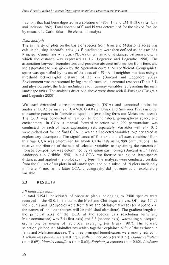
Data analysis The similarity of plots on the basis of species from ferns and Melastomataceae was calculated using Jaccard's index (J). Bioindicators were then defined as the axes ofa Principal Coordinate Analysis (PCoA) on a matrix of distances between plots, in which the distance was expressed as I-J (Legendre and Legendre 1998). The association between bioindicators and presence-absence information frorn ferns and Melastomataceae was given by the Spearrnan correlation coefficient. Geographical space was quantified by means of the axes of a PCoA of neighbor matrices using a threshold between-plot distance of 35 krn (Borcard and Legendre 2002). Environment was represented by log-transforrned soil elemental reserves (Table 5.1) and physiography, the latter included as four dumrny variables representing the main landscape units. The analyses described above were done with R-Package (Casgrain and Legendre 2000).
We used detrended correspondence analysis (DCA) and canonical ordination analysis (CCA) by means of CANOCO 4.0 (ter Braak and Smilauer 1998) in order to examine patterns in floristic composition (excluding ferns and Melastomataceae). The CCA was conducted in relation to bioindicators, geographical space, and environment. In CCA, a manual forward selection with 999 permlltations was conducted for each of these explanatory sets separately. Variables with P ~ o. l 5 were picked out for the final CCA, in which al! selected variables together acted as explanatory descriptors . The significance of first axis and alJ axes combined from this final CCA was detel111ined by Monte Carlo tests using 999 permutations. The relative contribution of the sets of selected variables to explaining the patterns of floristic composition was determined by variation partitioning (Borcard et al. 1992; Anderson and Gribble 1998). In all CCA, we focused scaling on inter-species distances and applied the biplot scaling type. The analyses were condllcted on data from the full set of 40 plots in all landscapes, and on a subset of 19 plots made only in Tierra Firme . [n the latter CCA, physiography did not enter as an explanatory variable.
5.3 RESULTS
Alllandscape unils In total 53941 individuals of vascular plants belonging to 2480 species were recorded in the 40 O. l -ha plots in the Metá and Chiribiquete areas. Of these, 17473 individuals and 132 species were from ferns and Melastornataceae (see Appendix 4; the names of the other species will be published elsewhere). The gradient length of the principal axes of the DCA of the species data (exclllding ferns and Melastomataceae) was 7.5 (first axis) and 3.5 (second axis), warranting subseqllent ordinations by means of reciprocal averaging (ter Braak 1987). The forward selection yielded ten bioindicators which together explained 61 % of the variance in ferns and Melastornataceae. The three principal bioiridicators were mostly related to Trichomanes pinnalum (rs = 0.77), Cyalhea macrosora (rs = 0.71), Danaea elliplica (rs = 0.69), Mouriri cauliflora (rs = 0.65), Polybolrya caudata (rs = 0.60), Lindsaea
58
FeJ"ns ond JIItdllS lo m OfOCeae liS illdirafol"\' (~( I !ClSCII/UI' p/anl compos iliun
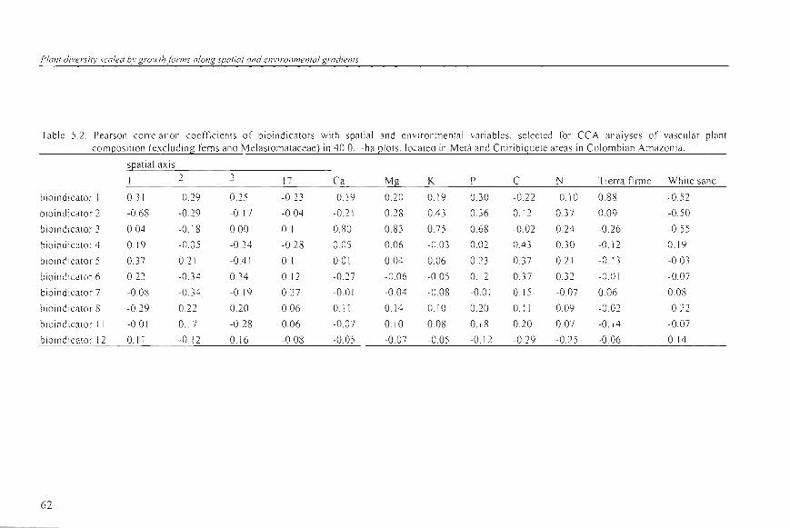
eoore/a/o (rs = 0.58) (all bioindicato r 1) ; Adion/u/11 /omenlosum (rs = 0.81), Miconia AD6297 (rs = 060), Mouriri myr/ijo/ia (rs = 0.54) (all bi o indicator 2); and Lomariopsis japurensis (rs = 0.63) (bioindicator 3). These three axes were more strongly associated with the se lected spa ti a l and environmental variables than the less important axes (Table 5.2) . Bioindicato r I co ntained infonnation quite si milar to that of the Tierra firme class (rs = 0.88). Bioind ica tor 2 was wel! associa ted to the ¡¡rs t spat ia l PCoA axis (rs = -0.68), while bio indicator 3 showed a s trong pos itive correlation with th e so il content of Ca, Mg, K , an d P.
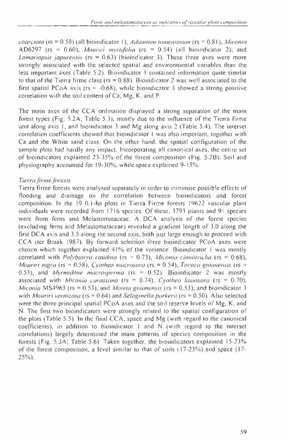
The mai ll axes ol' the CCA ordination di splayed a strong se paration of th e main forest types (Fig. 5.2A; Table 5.3), mostly due to the intluence of th e Tierra firme unit along axis J, and bioindicator 3 and Mg a long ax is 2 (Table 5.4) . The interse t corre lation coe fficients showed th at bioindicator 1 was a lso important, togethe r with Ca and the White sand class. On the other hand , th e spatial configuration of the sample plots had hardly any impact. Incorpo rat ing all canonical axes , the ent ire set of bioindi ca tors explained 23-35% of the forest composition (F ig. 5.2 B). Soil and physiography accounted for 19-3 0%, whi le s pace explained 9-15%.
Tierra/inne fores/s Tie rra firm e forests were ana lysed separately in order to minimise possi bl e effects of tloodin g and dra inage on th e correlation between bioindicators and forest composition . In the 19 O. I-ha plots in Tierra Firme forests 19622 vasc ular plant individuals we re recorded from 171 6 species. Of these, 3793 planls and 91 species were from ferns and M elastomataceae. A DC A analysis of the forest species (excluding fems an d Melas tomataceae) revea led a g radient length of 3.0 along the first DCA axis and 3.5 along the second axis, both just 1arge enough to proceed with CCA (ter Braa k 1987). By forw ard se lec ti on three bioindi ca tor PCoA axes were chosen which together explained 41 % o f the va riance . Bioindicator 1 was mos tly corre lated with Po/yboli ya caudala (rs = 0.73), /vliconia cionolricha (rs = 0.68), Mouriri nigra (rs = 0.58), Cyalhea n70crosora (rs = 0.54), Tococo guial1ensis (rs = 0.53) , and !vlyrmidone macrosperma (rs = 0 .52). Bioindicator 2 was mostly associated with Miconia carassana (rs = 0.74), Cyalhea /asiosora (rs = 0.70), Miconia MS4963 (rs = 0.53), and Maie/a guianensis (rs = 0.53) , and bioindicator 3 with MOtlriri vernicosa (rs = 0.64) and Se/agineLla parkerii (rs = 0.50). Also se lected were the three principal spati a l PCoA axes and th e soil reserve leve ls 01' Mg, K, and N. The tirs t two bio indicators were stron gly re lated to the s pa ti a l configuration of the plots (Ta ble 5.5) . In the fin al CCA, s pace a nd Mg (with regard to the ca nonical coeffic ients), in addition to bioindica tor I and N (with rega rd to the interset corre lations) largely determined lhe main patterns o f spec ies compos ition in th e fores ts (Fi g. 5.3A; Table 5.6) . Taken toge th er, the bioindica tors ex pl a ined 15-23% of th e fo rest composition, a leve l s imilar to that o f soil s (17-23 %) and s pace (1725 % ).
59
Plan! J/I er<ltl · .\calc" 1'.1· g roll rlt ¡or ll/I' U/OH!; ' parial Ol1d ,' I11 ' /I"() I1/IICllful g radlt!/IIs
Table 5.1. Soil e lemental reserves Illeasured al 70 cm so il depth in the difterent landscape units in the Melá and Chiribiquete areas in Co lombi an Amazon ia. Silo\\ n are al erages ± on e standard de via ti on of n plOlS
n Ca Mg K Na P e N
J1lJ1l0Iikg %,
F100d plains 8 105.6 ± 98.7 21 5.7 :::: 171.7 27 5.4 ± 161.7 207.8 ± 203A 9.6 ± 4 A 0.5 ± 0.1 0.1±0.02
Sw,mlps 8 3.7 =: 2.0 71.7 ± 323 160 .2 ± 69.6 27 .7 ±1 1. 2 12. 9±8A 9.5 ± 13.7 0.6 ± 0. 7
Ti erra firme 19 I. X± O 7 30.9 ± 2 1.7 60.0: 54.7 14.5 ± 14 .6 5.2 ± 1.5 OS ± 0.3 0.05 ± 0.03
White-sands S 1.4 ± 1.0 IA ± 0.7 1.1 ± 0.5 1.0 ± l A 0.6 ± 0.3 l.6 ± 1.5 0.02 ± 0.01
60
A 6
~
.1
('l
'" x 2'"
~ U U
- 1
-2 ~ - I o
6. V/~
o / . [:, O/.
6.
LJ o
•DO
• r. ~~,
Ferns amI melas /oma/aceae as inúica/o/'s o/ vasc /l lo /' plan/ composi/iol7
Floouplain
SII'amp
Tie rr .. l'irmc
Whik sanu
V
B
~ Hininui ca lors / + ,p;I\:<:
1-'11I' imnlTIcnl
"" Spacc Hi "i llllic;Jlors + cnl 'ironmenl
lli oilldiGII(lr ' + cnl'ironlm:nl + spacc
ceA ax is 1
Figure 5.2. CCA of vasc ular planr cOll1posili on (exc lu ding t'e nl s and Melasloma taceae ) in 40 (U -ha pl Ols. localed in Melá ancl Chir'ibiqu t' le areas in Co lomb ian Amazonia. A: Ordinalion diagram show ing sa ll1plc scores derived from the spccies fro ll1 lh e Melá area (open sY lll bols) a(\(1 lhe Chiribiquete area (c losed symbols): B: panilioning of the va rialion exp lained by lhe di ITeren l s ei S 01' cO lllbinali ons of seis 0 1' explanalory va riab les. ün ly ponions 0 1' lh e va riali on :> 1% ¡¡re show n. The fírst CCA ax is (F-ralio = 0.RR5 ) and all axes togel her (F-rillio = 1.246) were signilicant al P = 0.00 1.
6 1
Planl diversily scaled bv grol1'Ih fonns along spalial and en vironmenlal gradients
Table 5.2 . Pearson correlat ion coefti cients of bioindicators with spati al and env iron mental va riab les, selected for CCA an alyses of vascular plant composition (excl uding fems and Melastomataceae) in 40 O. I-ha plots, located in Metá and Chiribiquete areas in Colombian Amazon ia.
sl2at ial axis 2 3 17 Ca Mí! K P C N Tierra firme White sand
bioindicator 1 0.31 -0. 29 0.25 -0.23 -0. 19 0.20 0.19 0.30 -0.22 -0.10 0.88 -0.52
bioindicator 2 -0 .68 -0.29 -0 .17 -004 -0.21 0.28 OA 3 0.36 0.12 0.37 0.09 -0.50
bioindicator 3 0.04 -0.18 000 01 0.80 0.83 0.75 0.68 -0 .02 0.24 -0.26 -0 .55
bioind icator 4 0. 19 -0.05 -0.34 -0. 28 0.05 0.06 -0 .03 0.02 OA3 0.30 -0. 12 0.19
bioindicator S 0.37 0.2 1 -OAl 0. 1 0.0 1 0.04 0.06 0.23 0.37 0.21 -0. 13 -0.03
bioindicator 6 0.22 -0 .34 0.34 0.12 -0. 27 -0.06 -0 .05 0.12 0. 37 0.32 -0.0 1 -0.07
bi oindicator 7 -0.08 -0.34 -O. J 9 0.27 -0 .01 -0 .04 -008 -00 J 0. 1 S -0.07 0.06 0.08
bioindlcator 8 -0.29 0.22 0.20 0.06 0.11 0.14 0.10 0.20 0.11 0.09 -0.02 -0.22
blO indicator 11 -0.0 1 0. 17 -0.28 0.06 -0.07 0. 10 0.08 0.18 0.20 0.07 -0.14 -0.07
bioll1dicator 12 0. 17 -0. 12 0.16 -0 .08 -0.05 -0. 07 -0.05 -0.12 -0 .29 -0. 25 -0 .06 0.14
62
Ferns une! lIIelasIO"'IO /uceue os ine!icafOrs a/ vasculor planl camposiflon
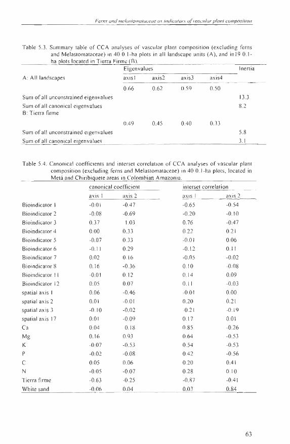
TabJe 5.3 . Summary table of CCA anaJ yses 01" vasc ul ar plant eomposition (exeluding ferns and Melastomataeeae) in 40 O. I-ha plots in all landseape uni ts (A), and in 19 0.1ha plots loea ted in Tierra Firme Un.
Eigenva lu es ¡nenia
A: A Illand scapes axi s 1 axis2 axi s3 axis4
0.66 0.62 0.59 0 50
Sum of a ll un eonstrai ned eigenvalues
Sum 01' all eanonieal eigenvalues B: Tierra firme
133
8. 2
0.49 0.45 OAO 0.33
Sum of all un eonstrained eigenvaJues
Sum 01' all eanoniea l eigenvalues
5.8
3. 1
Table 5.4. Canonie al eoeftieienls and inlersel eorrelalion ol' CCA anal yses ol' vascular planl eompos ilion (exeluding fern s and Melaslomalaceae) in 40 O. I-ha pIOIS, loealed in Melá and Chiribiguele areas in Co lomhian Amazonia.
eanon¡eal eoeffic ienl inlersel correlalion
a\ is I ax is 2 axi s J axi s 2
Bioindicalor I -0.0 1 -OA7 -0 .65 -0.54
Bioindicalor 2 -0.08 -0.69 -0.20 -0.10
Bioindicalor 3 0.37 - 1.03 0.76 -OA7
Bioindieator 4 0.00 0.33 0.22 0.2 1
Bioindicator 5 -0.07 0.33 -0.0 1 0.06
Bioindicalor 6 -O I1 0.2 9 -0.1 2 0. 11
BJOindicator 7 0.02 016 -0.05 -0.02
Bioindicator 8 0.16 -0.36 0.10 -008
Bioindicator 1 I -0.0 I 012 0.14 0.09
Bioindicalor 12 0.05 0.07 0. 11 -0.03
spatial axi s I 0.06 -OA6 -00 I 0.00
spatia l axis 2 0.01 -00 1 0.20 0.21
spali al axis 3 -0.10 -0 .02 -021 -0. 19
spalial ax is 17 0.0 1 -0.09 o. ¡ 7 0.0\
Ca 0.04 -0 18 0.85 -0.26
Mg 0.16 0.93 0.64 -0 .5 3
K -0.07 -0.5 3 0.54 -0.53
P -0.02 -0 .08 OA2 -0 .56
C 0.05 0.06 0.2 0 0.41
N -0.0 5 -0.07 0.2 8 0.10
Tierra fi rme -0.63 -0 .2 5 -0 .87 -OA \
White sa nd -0 .06 0.04 0.03 0.84
63
N VJ
x c,;
<C U U
Plan/ divasi/)' scaled by gl'Ol v/h(orms alo l1g spa/ial a /ld enviro/ll11en/al gradie/l/s
5.4 DISCUSSION
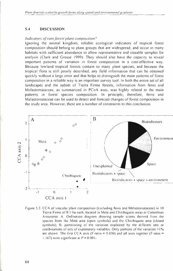
Indicotors o[rain lorest plont composition ') 19noring the animal kingdom, reliable ecological indicators of tropical forest composition should belong to plant groups lhat are widespread , and occur in many habitats with sufficient abundance lo allow representalive and sizeable samples for analysis (Clark and Grosse 1999). They should also have the capacity lo reveal importanl patterns of variation in forest composition in a cosl-effective way. 8ecause lowland tropical foresls contain so many plant species, and because the tropical flora is still poorly described, any field information that can be obtained quickly without a large error and that helps to distinguish the main patterns of forest composition in a reli able way is an important survey tool. In bolh the entire set of all landscapes and the subset of Tierra Finne forests , informalion from ferns and Melastomataceae, as summarized in PCoA axes, was highly related to the main patterns in forest species composition. In principie, therefore, ferns and Melastomataceae can be used to detect and forecast changes of forest composition in the study area. However, there are a number of constraints to this conclusion.
A 2 00
o Mct ú o o
~o O o o
0$8
- 1 Chirihiqucte
• -2 I •
- 1 O
CCA axis 1
#
2
B
Uncxpl a incd ./
Aioindicators + spacc \
Environmcnt
Bioindicators + space + en\'ironment
Figure 5.3. CCA 01' vascular plant composition (excluding ferns and Melastomataceae) in 19 Tierra Firme of O.I-ha each, located in Metá and Chiribiquete areas in Colombian Amazonia. A: Ordination diagrarn showing sa rnple scores derived fr orn the species frorn the Metá area (open syrnbols) and the Chiribiquete area (closed symbols); B: partitioning of th e variation explained by th e different sets or combinations of sets of explanatory va riables. Only portions of the variation > 1% are sho wn. The first CCA axis (F-ratio = 0.830) and al! axes together (F-ratio =
1.167) were signiticant at P = 0.001.
64
Ferns une.! l1IellJslOlllalareae us indica /ors ofvascu lol" plan/ composifian
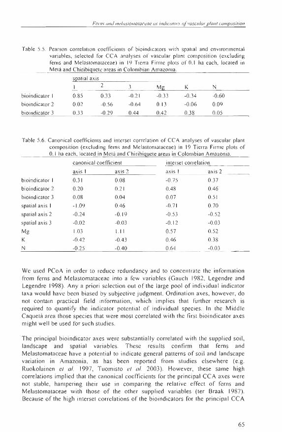
Table 5.5 . Pearson correlation coef/ic ient s of bioi ndi cators with spatia l and envi ronmental va riables, se lected for CCA analyses of vascular pl ant composi ti on (exc luding fern s and Melas tomalaceae) in 1':) Ti erra Firme plots of 0.1 ha each, located in Melá and Chiribiguetc areas in Colomhian Amazonia,
sQatial axi s
I 2 3 Mg K
bioindicalor 1 085 0. 33 -0.2 1 -0 .33 -034 -0 .60
bioindicator 2 0.02 -0 .56 -0.64 0. 13 -006 0.09
bioindicator 3 0.33 -0.29 OA4 OA2 0.38 005
Table 5.6. Canon ical coefticients and interset correlation of CCA ana lyses of vascular plant compos ition (excluding fe rns and Melastomataceae) in 19 Tierra Firme pl ots of 0.1 ha each, located in Metá and Chirihiguete areas in Co lombian Amazonia.
canonieal coefficient i nterset correlat ion
axi 1 axi 2 axis 1 axis 2
bioindicator 1 0.31 008 -0 .75 037
bioindica lor 2 0.20 021 OA8 OA6
bioindicator 3 0.08 0.04 0.07 0.51
spalial axis 1 - J.O':) OA6 -0.7 1 0.70
spalial axi s 2 -0.24 -0. 19 -0.53 -0.52
spatial axi s 3 -0.02 -0.03 -0.12 -0.03
Mg 1.03 1.11 0.57 0.52
K -OA2 -O A3 OA6 0.3 8
N -0.2 5 -OAO 0.64 -0.03
We used PCoA in order to reduce redundancy and to concentrate the information from feros and Melastomataceae into a few variables (Gauch 1982, Legendre and Legendre 1998). Any a priori selection out of the large pool of individual indicator ta xa would have been biased by subjective judgment. Ordination axes, however, do not contain practical fi eld information , which implies that further resea rch is required to quantify the indicator potential of individual species. In the Middle Caquetá area those species that were most correlated with the first bioindica tor axes might well be used for such studies.
The principal bioindicator axes were substantially correlated with the supplied soil, landscape and spatial variables. These results confirm that fero s and Melastomataceae have a potential to indicate general patterns of soiJ and landscape variation in Amazon ia, as has been reported from studies elsewhere (e.g. Ruokol ainen el al. 1997, Tuomisto el al. 2003). However, these same high correlations implied that the canonica l coefficients for the principal CCA axes were not stable , hampering their use in comparing the relative effect of ferns and Melastomataceae with those of the other suppl ied variables (ter Braak 1987) . Because of the high interset correlations of the bioindicators for the principal CCA
65
Plonl <liven il) ' .\colad h)' gUllrlh j imm olong .\'[loliol (In" em'ironll1('/1/ol gro"i"nls
axes, no evidence was obtained that felllS and Melastomataceae show more potential lo predict the main patterns o f foresl cOlllpos iti on than the other variables. This implies that when botanical ex perts are ava ilable, infolmation from fe rns and Melastomataceae might orfer an effec ti ve way to map the main patterns in forest composition . In other circul1lstances, fi eld data of so il s and main landscapes might offer quite similar information . The cos t-effe cli veness of these two indicator melhods was outside the scope o f lhis case-study.
Overo!! varialíul1 in :;pecics composiliol1 Th e variation partitioning yields a bi ased outcome, as small sample sizes in diverse tropical lowland forests, either by small or by fe w large plots (01' transects), inev itab ly leads to undersampling 01' locally rare species. As a result, between-plot s illlilari ty tends to be undereslimaled (Pitman 200 1) which , in turn , mighl reduce the overall amount of variation ex pl ained. There is no easy so lution for Ihis old survey problem (e.g., Schulz 1960), as increased sa lllpling intensities will yie ld more loca ll y rare species and , therefore, more noise. On lhe other hand, most of the variation is concenlraled in tIJe prin cipal ordination axes that are built up by the main sl mil arily patterns, and are less innuenced by the sampling effect Ihan subordinate axes.
The relationships of ferns and Melaslolllalaceae lo thc patterns of oth er plants in lhe forests was lo a substanti al degree independenl from that 01' lhe other seIs of expJ analory variables, both in the enlire analysis as in that from lhe tierra firm forests (Figs. 28 and 38) . This is probably due lo the e ffe ct of the subordinale bioindicators, beca use the principal ones were well co rrelated to the soil , landscape and spatial variabl es (see also Legendre and Legendre 1998). lt is hard to di sti ngui sh between direct or indirecl effect s here. The vascular pl ant composition 01' tropi ca l forest s depends on a variety of faclors, many of which lack any relat ionship to soils or ab iotic environm ent (Condil 1996, see al so Enquist el a!' 2002). Any large subset o f plants taken from the forcsts wi 11 show lhis dependency. Therefore, it is highly Jikel y thal, by default, subsets 01' forest planls will be correlated to each other. lndeed, apart from ferns and Melastomataceae, palms and other taxa have been reported as indica tors of Amazonian foresl cOlllposition as well (Vormisto el al. 2000). Correlative studies of plant indicators to other su bsets might simply not yield sufficient infonnati on to separate direct effects from those derived fro m indirect correl alions, given the complex ity of the factors governing tropi ca l forest compositional patterns. Ev idence of direc t effecls may come from detailed experimen tal studies o f between-plant interactions. Most fern s and Melastomataceae belong to differenl funclional plant grou ps than trees and lianas. With regard to the understory habitat and predominant herbaceous and shrublike appearance of ferns and Melastomataceae , future studi es to delect such interactions should lO concentrate on Ihe seedl ing or Ju venile stages of trees and lianas , both above-ground as well as in the root ing environl1lent.
Chapter 6
DIVERSITY AND COMPOSITION OF WOODY LIANAS IN NW AMAZONIA
Alvaro J. Duque M. , Joost F. Duivenvoorden, Mauricio Sánchez, Jaime Cavelier, Hugo Romero-Saltos , Renato Valencia, Manuel Macía, César Grández and Alberto
García Submitted to Global Ecology and Biogeography
6.1
Dlvel 'Si~l' und c()J}/f}osit ioJ] (~r ""00(,(1 ' liono.s i/1 N i-V Amazonill
lNTRODUCTlON
Woody lianas are a significant plant group contributing to the total plant diversity and the dynamics of the tropical rorests (Putz 1984, Phillips and Gentry 1994, Schnitzer el al. 2000, Phillips e l al. 2002). These climber plants, as well as other groups like epiphytes, shrubs, and herbs, have been ignored in many inventories and vegetation models (Schnitzer and Carson 2000). As a result, information of the ecology and function of lianas is still scanty and sometimes even contradicting. Lianas were considered light demanding species (Putz 1984) but recent studies showed that they are also tolerant to low light intensities on the rorest floor (NabeNielsen 2000). Wind has oflen been mentioned as important for the dispersal of lianas (Gentry 1991 b, Killeen el a/. 1998). Many lianas , however, may reproduce by clones (Nabe-Nielsen 2000). The density and species richness of lianas at local scale ha ve been related to forest architecture and structure (Putz 1984, Nabe-Nielsen 2000), but also to the successional stage of the forests (Dewalt el al. 2000). A positive relationship between soil fertility and density of lianas has been suggested for Amazonian and Malaysian forests (Putz and Chai 1987, Gentry 1991 a) but was not found in Mexico (lbarra-Manríquez and Martínez-Ramos, 2002). Clumps of vines were also interpreted as biological markers of forest disturbance (Balée and Campbell 1989, Hegarthy and Caballé, 1991). Increased seasonality in precipitation was posilively associated with the abundance of lianas (Gentry 1991a, PérezSalicrup el a/. 2001) but negatively wilh theír species richness (Clinebell el al. 1995). Rising atmospheric concentrations of CO} might enhance density and dominance of lianas in western Amazonian rain forests, bul failed to have a clear effect on their floristic composition, di stribution, and compositional turnover rates (Phillips e l a!' 2002).
With so many biotic and abiotic environmental factors playing a role in the establishment and maintenance ol' liana diversity, and the likeliness that these act together, a search for a single explanatory variable is not useful (Balfour and Bond 1993). Spatial mechanisms may also determine the floristic composition 01' a local community, embedded in a larger and heterogeneous landscape (Holt 1993, Legendre and Legendre 1998). Species diversity at regional and local spatial scales is strongly influenced by the interaction between environmental heterogeneity and dispersal (McLaughin and Roughgarden 1993). When the local species richness in a similar habitat type but in di fferent regions varies signil~cantly, the hi storical and biogeographical influence may become more relevanl (Ricklefs and Schluter 1993).
This paper aims to as sess the hitherto unexplored patterns of liana diversity and composition at local and regional scales in NW Amazonia (Fig. 6.1). NW Amazonia has become known for its high plant divers ity , mainly recorded in the surroundings of three centres 01' tield research lhat were located in each of lhe three countries involved (lquilos area in Peru: Gentry 1988; Yasuní area in Ecuador: Valencia el a/. 1994; Araracuara area in Colombia: e.g. Duivenvoorden and Lips 1995). NW Amazonia is stilJ largely covered by non-fragmented 'virgin' rain forests (no fragmentalion), which are situated in a lowland setling (neglectable altitudinal gradient). The whole area has a largely similar geomorphology comprised by sedimentary plains that are more or less di ssec ted in dense subdentritic drainage systems (Dumont el al. 1990). It has a humid rain fall regime with a low seasonalily,
7J
Plan/ diversí/y .\'ccded by grul\'/hjónns alol1g slJlI /íal al1(l enl'íl'o/1/nen/at gmdien/s
and has probably undergone a simil ar rainfall in the Pleistocene and Holocene (e.g. Colinvaux el a/. 2000, Hooghiemstra and van der Hammen 1998). As these importanl environmental fa ctors show relatively little regional yariation, NW Amazonia is especially suilable for wide-scale comparisons of rain forest diversity. Diversity and composition of woody lianas that occurred with a minimum densily of 25 rooled slems in series ol' scattered O.I-ha plots made in each of the 'hotspot areas' mentioned aboye, were relaled to physiography, soil, and forest slructure in multiple regression and canonical ordination analysis. With respect to the reg ional location and the fine resolution (applying diameter cul-off 01' 2.5 cm), our sludy is complementary to comparati ve studies al wide lropical scales (C1inebell el al. 1995) or Amazonian scales (Terborgh and Andresen 1998, Pitman el a/. 1999, 200 1, Ter Steege el a/. 2003).
6.2 METHODS
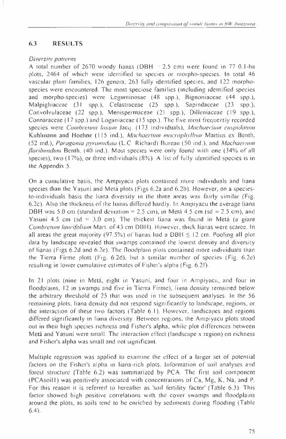
Study sile The sludy was carried out in three different areas in NW Amazonia: Melá, forming parl of the middle Caquelá basin in Colombia; Yasuní in Ecuador; and Ampiyacu pertaining lo the Maynas Province in Peruvian Amazonia (Fig. 6.1). AII areas are in the HlImid Tropical Forest life zone (bh-T) according lO Holdridge el a /. (1971). The average temperature is near 25°C, and annual precipitalion varies around 3000 mm. AII months show an average precipitation aboye 100 mm (Lips and Duivenyoorden 2001).
Vegetalion samp/ing and identification oibotanical vouchers A total of 80 O.I-ha plots were established: 30 in Metá and 25 in both Yasuní and Ampiyacu. In order to es lablish the plOlS, starting locations and lhe direction of the lracks along which the foresls were entered, were planned on the bas is of the interpretation of aerial pholographs (Duivenvoorden 2001) and satellite images of Landsat TM (Tuomisto and Ruokolainen 2001). During the walk through the forests , soils and terra in units were rapidly desc ribed , and foresls were visllally examined. In this way sites with homogeneous so ils and physiognomically uniform forest stands were identified . In these stands, rectangular plols (mostly 20 x 50 m) were delimited by compass, tape and stakes, working from a random starting point, with the restriction thal the long side of the plot was parallel lo the contour line. Plots were loca ted without bias wilh respec l to floristic composition or foresl structure (including aspects of lree density , lhickness and height, and presence of li anas). They were mad e in forest thal lacked signs of human intervention . The only exception to this were some swamp plots in the floodplain of the Ampiyacu River in Peru, where few palms had been cul recently to harvesl fruils from Maurilia flexuosa L.f. Plots were established at a minimum between-plot distance of 500 111
and were mapped with GPS. They were subdivided into subplots of 10 x 10m, in which all lianas with DBH ~ 2.5 cm were numbered and measured with tape. Lianas were defined as those woody plants that establi shed as seedlings on the forest so il , ga in ed access to upper canopy by using other plants as support, and remained rooted in the soil throughout their li yes. According lo these criteria, epiphytes and hemiepiphytes were excluded (Schnilzer and Bongers, 2002). Fieldwork took place in 1997 and 1998.
72
DII'el'sify ol7d compo,ülion V(Il'{)(l(!1' 1i1l110.\ in NI..VAmazonia
Botanica l co llections were mad e ol' all liana species (OBI-! ~ 2.5 cm) found in each plot. Identifi ca tion too k place at the herbaria COA H, QCA, QCNE, AMAZ, USM, MO, NY and AAU (Holmgren el a/. 1990). The nomenc lature of families and genera followed Mabberley ( 1989). Within families or groups of close ly allied families, spec imens that couJd not be identified as spec ies beca use of a Ja ck of su fficient dia gnosti c characteri stics, were clustered into rnorpho-species on the bas is ofs imultaneous rnorphological compariso ns with all other specimens.
~ , '.
~~7~8°____~~__~-;75~'_' ____________~7=2-·-- 69°
Amazonia
Meta Araracuara ::J
" t
PERú IQultos o
BRAZIL "
Fi gure 6. 1. Loca ti on ofthe three study sit es in NW Amazonia .
In the central part of each plOI, a so il auge ring was don e to 120 cm depth in order to describe the mineral so il hori zons (in term s of colour, mottling, hori zo n boundaries, presence of concretions, and texture) and to define soi l drainage (in c lasses of FAO 1977). At each augering a so il samp le was taken at a depth of 65-75 cm. For analyses, soi l sa mpl es were dri ed at temperatures below 40°C, cru mbl ed and passed through a 2- rnm sieve. Total content of Ca, Mg, K, Na, and P was deterrnined by means of atomic emission spec trometry of a subsa mple of 100-200 mg from the sieved fraction, that had been di gested in a solution of48% HF and 2M H2SO. (after Lim and Jackso n 1982). Total content of C and N was determined for the sieved fraction by means of a Cario Erba 1 106 elemental analyser. Soil analyses were done at the so il laboratory of Institute for Biodiversity and Ecosystem Oynamics of th e Universiteit van Amsterdarn.
Dala ana/ysis Pl ot-based acc umulation curves (Gotelli and Cülwell 200 1) we re made by success ively pooling of li ana species and individuals recorded in randomJ y ordered
0°
2°S
4°8
74
P/unf din?rsi l..v seo /ce! hy gJ'owfh/()/"IIJ.\ %ng "{Juliu/ (l}uJ et/I 'II'()nmenlal g)'(ld;c~nls
plots. A total of 56 plots, each with 25 li anas or Illore, were used for ANOVA and regression 3nalyses 01' diversity , and ordin ation analyses 01' species patterns. Differences in number 01' individual s, famili es , ge nera, species, and Fi sher' s alpha based on species were analyzed by means 01' a lwo-way ANOV A witil landscape and region as fa clors. For thi s ANOVA , landscape was class ified in the three phys iographic units where the pl ots were made: well-drained floodpl ains, swamps, and well-drained uplands (Tierra Finne). The first t\Vo landsca pe units were periodi ca ll y flooded by river wate r (a ll swamps pertained to the fl oodplains of lhe main rive rs), the last unlt no!. The reg ion was simply taken as the area where plot were located (Metá, Yasuní, Ampiyacu) . Fisher's alpha was calculaled using Newton 's method (Fisher el al. 1943 ; Condit el al. 1998). AII response variab les in th e ANOV A's were In-transformed.
Multipl e regress ion was done of Fisher's alph a aga inst environmenlal and spatia.1 variables that were also used in the canoni ca l co rres pondence analysis (CCA) 01' li ana spec ies patterns. In addition to the landscapc factor (see aboye) the fo ll owing explanalory va ri ab les we re used in thl s analys is:
• Cover ofeach ofthe three landsca pe unils, detennined with Landsa t TM imagery and aer ial photographs in a circle with radius of 1 km, centred on each plot. When the area around the plot was par! o f a ri ve r, it was taken as fl ood plain. Before ana lyses. the three cover vari abl es were In-transformed.
• Forest structure summarized in lhe first two axes 01' a principal components analys is (PCA) of plot densiti es of non-liana individuals (hereafter simply ca ll ed lrees ) in s ix DBH classes (25 ~ DBH < 5 cm, 5 ~ DBH < 10 cm, 10 ~ DBH < 20 Clll, 20 ~ DBI-I < 40 cm, 40 ~ DBH < 60 cm, and OBH 2':. 60 Clll). Before PCA, densit ies were In-transforllled and sta nd arcli zecl.
• So il chemica l informatlon sumlllari zed in the j~ rst two axes 01' a PCA 01' total concentrati ons of Ca, Mg, K, Na, P, e and N, sampled at 65-75 cm so il deplh in each of the plOlS. Bcfore PCA, so il va riab les were In-trans fonned and standard ized.
• Latitudinal and longitudinal coordlllates ofthe plots in decimal degrees.
In ANOVA and multiple regression , sa lllples were visually inspected for homosceclast icity. Residuals from all ana lyses were nol different from n0 l1l1 a I (Shapiro-Wilk W test, p> 0.05), They also dicl not show any spatial dependence, as tested by Illeans of the signifi ca nce 01' Moran's 1, after progress ive Bonferroni cOlTections us in g nine equal-widtil c lasses 01' In-lransformed di stances in the Autoca r modul e of R-Package R 4.0 (Casgra in el al. 2000). The di stance matrix for thi s ana lys is was caJcu lated in km with the Geographic Distance module in R package R 4.0 (Casgrain el al. 2000) , app lying the latitudinal and longitudinal coordina tes 01' the plots in decimal degrees. ANOVA, PCA and multiple regression were done with JMP 3.1 (SAS Institute 1994). Detrended Correspondence Analysis (DCA) and CCA 01' log-transformed basa l area of species were done \Vith CANOCO 4 (ter Braak and Smilauer 1998). The significa nce of the f¡rst CCA axis and a ll CCA axes comb ined was determined by Monte Cario tests using 199 permutations under reduced model (ter Braak ancl Smilauer 1998). AII regressor variables se lected in the final models showed variance infl at ion factors less than flve.
DiI -e,-si!y ond cOIl1{Jo,\Iúon olll"()()(~)' lio/1u.' 111 N W Amazonia
6.3 RESULTS
Oiversily pallerns A total nU lllber of 2670 woody li anas (DBH 2.5 cm) were fou nd in 77 O. I-ha plots, 2464 of wh ich were ident i fied to spec ies or Illorpho-spec ies. [n to tal 46 vasc ul ar plant families, 126 genera, 263 fully ident itied spec ies, and 122 morphospecies were encountered. The most spec iose fam il ies (including identitied spec ies and morpho-species) were Legulllinosae (48 spp.) , Bignoniaceae (44 spp.), Malpi ghi aceae (31 spp.), Celastraceae (25 spp.), Sapindaceae (23 spp. ), Convolvulaceae (22 spp .), Meni spermaceae (2 1 spp.), Dill eniaceae ( 19 spp.) , Connaraceae (17 spp.) and Loga n iaceae ( J 5 spp .). The fíve mos t freq uentl)' recorded spec ies were Combrelum /ax ul17 Jacq. ( 173 indi viduals), Machaerium cuspidalum Kuhllllann and Hoehne ( 115 ind .), Mac17acrium macl'Ophy //ulI1 Martius ex Benth . (52 ind .), Paragonia py ramidala (L.e. Richard) Bureau (50 ind .), and Machaerium floribundum Benth . (40 ind .). Mosl spec ies were only found witb one (34% of a ll spec ies), two ( 17%),01' tllree indiv iduals (8%). A lisl of fully identitied species is in the Appendix 5.
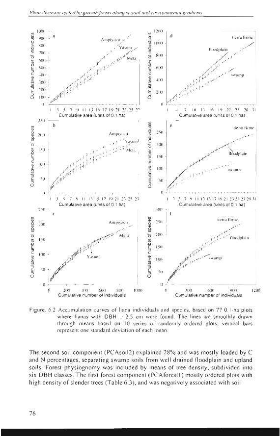
On a cllmlllat ive basis, the Ampiyacll plots contained more indi vidllals and liana species than the Yasuní and Metá plots (Figs 6.2a and 6.2b). However, on a spec iesto-indi vidual s basis tll e li ana diversily in the tbree areas was fairly s imilar (F ig. 6.2c). Al so the thickness oftlle li anas differed hardl y. In Ampiyacu the ave rage liana DBH was 5.0 cm (standard deviation = 2.5 cm), in Metá 4.5 cm (sd = 2.5 cm), and Yasuní 4.5 cm (sd = 3.0 cm). The thickcs t liana was found in Metá (a giant Combrelul11 /aurifo/ium Man. of 43 cm OB H). However, thi ck li anas were sca rce. In al! areas the grea t majority (97.5%) 01' li anas had a DBH :s 12 cm . Pooling a ll plot data by landscape revea led that swalllps contai ned the lowcst densily and di versity of lianas (F igs 6.2d and 6.2e). The fl oodpla in plots contai ned more indivíduals than the Tien'a Firme plots (Fig. 6.2d), bul a sim ilar number of spec ies (Fig. 6.2e) resu lting in lower cllmlllative est imales of Fishe¡"s alplla (F ig. 62f).
In 2 1 plots (nine in Metá, eighl in Yasuní, and four in Ampíyacu , and four in floodplains, 12 in swamps and five in Tierra Firme), li ana dens ity re mained be low the arb it rary threshold of 25 thal was uscd in lhe subseqll ent analyses . In the 56 remaining pl ots, li ana density did not respond s ignifican tl y to landscape, regions, or the interaction of these two factors (Tab le 6.1). However, landscapes and reg ions differed significantly in liana diversity . Between rcgions, lhe Ampi yacu plots stood out in their hi gh species ri chness and Fi she r's a lpha, while plot differences between Metá and Yasuní were small . The interaclion effect (Iandscape x regíon) on richness and Fis her' s alpha was small and not signi fica nt.
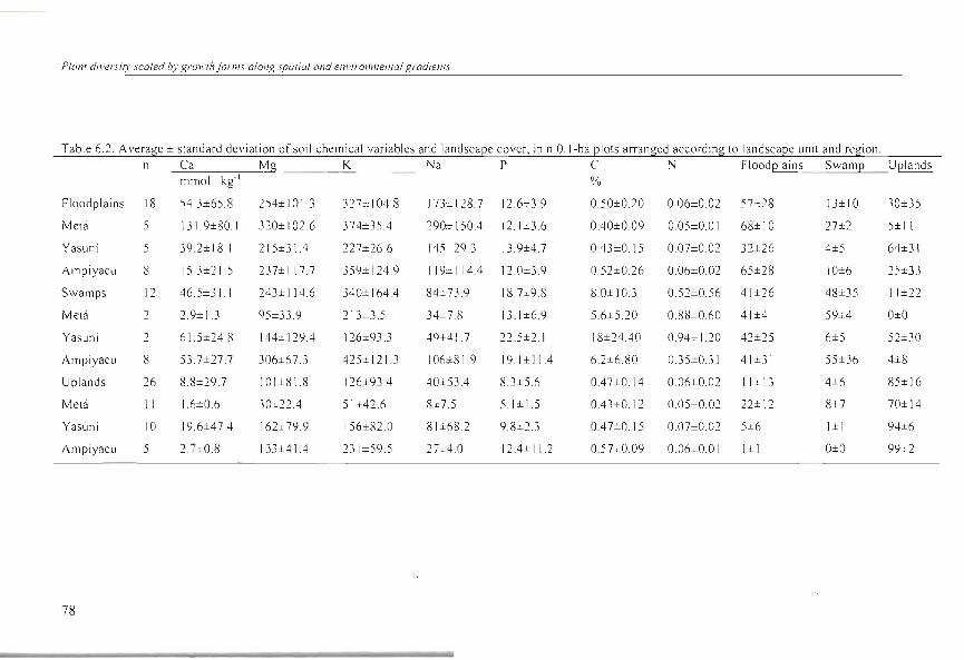
Multiple regress ion was applied to exam ine lhe effect of a larger set of potential factors on the Fish er's alpha in I.iana-r ich pl ots. Informalion of so il ana lyses and forest str llcture (Table 6.2) was summari zed by PCA . The first soil component (PCAso ill ) was positive ly assoc iated with concentrations of Ca, Mg, K, Na, and P. For thi s reason it is refe rred to hereafter as 'so il fel1ility fac tor' (Table 6.3). This factor showed high pos iti ve corre lati o ll s with the cover swamps and fl oodplains around the plots, as so ils tend to be enricll ed by sed iments during flooding (Ta ble 6.4) .
75
Planl div(!rsilV scaled h)' gmll 'lhfarms alang splllilll ami el7l '/r0I7I1'/(! I7/(11 g rad,ef'fl.\'
,'\ .' 7 9 1 1 13 l ' I 7 1') 2 1 1:1 25 27 ~ 7 10 U 11\ 19 22 25 2X 31
(f) IO(lO -
~ <¡(lO i a Alllpi):ICII / //
/.6 xoo Ya'UIlI //,/s 7(lO
'O /o f '" Ui óno, ", i .
/
~V'v Mel '¡ .D
51)0E "",A~~'::J e -l(11I
!?i ~OO ,1 ~(I ../p..... ~ ::J
::J
"".' gVJ/E l
U IO(l ] r r '
o
1200 ~-------------I (f)
tiro ti l.' ITU lirm l.'::J
:g 10011> TI nmul'l"ill ,,-y/S 'O HOO //Ui .D E (,IXI /'::J . ~./r' e X ",---'Yr- -1' -< _0' ..-' """mI'~ ~oo ~ ro :; /r~.>--I¡--0E :wo :J ( 1-::-:.-1' U
() IrC' " II 1, I .,
Cumulative area (Unl ts 01 0.1 ha) 2_50
b(f) Q)
Ampi.';u':lI. ~ 200 o. ,._-..-.....(f)
/.,..-r' y;¡~lJll ..'O.8 1,50 ,¡-Ir-r: ,~~,,;.:t?-~ -:-E yr::.t -tJ:rrJ--I~. Mel" ::J e
100 jA"'rj:..yt -1 r ' ~ ro )/v.::r-r:; -O
::J E , ~~~"
U
Cumulanve area (units 01 0.1 ha)
(f)
ro tiCl111 tirme:J
'O ~.:;()S TI e 'O 21X) A~ Ui .D //' n"c>upluill1_5 0E :J e Q)
I IXI / -y....-' ~--> .~ jl-~,¡-I+ , ' 1" -,""mI'l :; 50 E :J Al' U :/"
(1 -..~ --rT i i 1) 1 , • i i
<,¡ 1 1 1.1 15 17 I '! 21 2,1 25 27 1 _, -' 7 t¡ 11 1.1 1.5171<)212'\ 252729 ,1 1
Cumulative area (lJnlls 0 1 0_1 ha) 2:\0
e (f) Q)
Ampi.' ¡h.:U'~ 2nO o. (f) , r f.-~ o MO ;;; 150 .D
::J e
IlUiQ)
::: ro
E
_1'/ '''UI1; '"
:; E ,O i _, ::J U
O I
Cumula tive area (units 01 0, 1 ha) .lOO
(f) ti t,'rra Iirn1\.:Q.) 1:;¡O·u _. .,../
Q) o. y -/(f)
o 200 -.-1-;::---- ,-"J-:!'--¡--+ lIoouplai 11;;; .D ,n-"--'E 150 ::> ¿pX e Q) 1-- ' ~ ,---~~ ,,,,,mI'o::: 11)0 ro :; ,tr"E :J 51)
U /
O": o 20() ~OO 600 XOO 1000 o .lOO 600 l)(ll) 1200
Cumulali ve number 01 indlviduals Cumulative number 01 individuals
Figure , 6,2 Accumulation curves of liana individual s and spec ies, based on 77 0, I-ha plots where lianas with DBH O>: 2,5 cm were fo und , The lines are smOOlhly drawn throu gh means based on 10 series 01' randoml y ord ered plots; vertical bars represent one stan dard deviation of each mea n,
The second so il componenl (PCAsoiI2) explained 28% and was mostly loaded by C and N percentages, separating swamp soils from well drain ed floodplain and upland soils, Forest physiognomy was included by means of lree densily, subdivided into six OBH classes_ The first forest component (PCAforesl 1) mostly ordered plots with high density ofslender trees (Table 6,3), and was nega tively associated with soil
76
Diversily and composilion oJwoody lianas in NW Amazonia
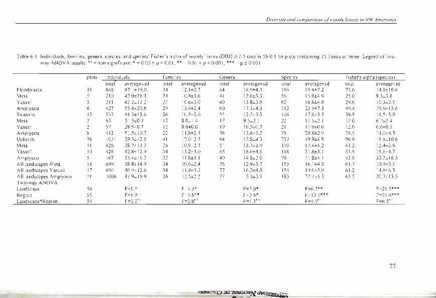
Table 6.1. Individuals, families, genera, species, and species' Fisher's alpha of woody lianas (DBH 2: 2.5 cm) in 56 O.I-ha plots containing 25 lianas or more. Legend of t"'o
\Vay ANOV A results: "' = non significant: * = 0.05 S P < 0.0 1; ** = 0.01 S P < 000 1; *** = P ~ 0.001
plOlS Ind~iduals Families Genera S[lecies Fi sher's al[lha (s[lecies l
total average±sd total average±sd total average±sd total average±sd total average=_sd Floodplains 18 848 47.1±19.0 34 12.1±2.7 84 14.9±4.3 186 19A± 7.2 73.6 14.1±10A Metá 5 210 42.0± 21 A 24 10.8±1.6 41 12.6± 3.3 56 150±4.9 25.0 9. 3~ .8
Yasuní 5 211 42.2± 13.2 22 10.6±3.0 40 13.8± 3.8 62 16.6±4.8 29.6 10.3± 3.5 Ampiyacu 8 427 53A±20.8 29 13.8±2A 60 17.1 J:4.5 112 23.9±7.5 49A 19.6± 13.6 Swamps 12 532 44.3± 13.6 26 10.Scc2.6 51 12.5-::3.3 106 17.6±5 .2 39.8 11 S :-5.0
Melá 2 63 315=0 7 12 8.0= 14 17 9.5=2.1 22 115±2.1 12.0 6. 7= 2A Yasuní 2 57 28 S ,-0.7 12 8.0±0.0 19 1 0. 5±0. 7 21 11.0±0.0 12.0 6.6=0. 1 Ampiyacu 8 412 515± 10.7 22 118±2.3 38 138::3.2 78 20.8±2.9 28.5 14.0±4.3
Uplands 26 1021 39 .3± 12.8 41 12.0 2.7 94 15.8±4.3 237 19.9±4.9 96.9 18.~± 10.6
Metá 11 426 38. 7:1 13.3 26 10.9 2.7 51 13.7= 3.9 103 17A±4.2 43.2 12A±2.6 Yasuní 10 428 42.8± 12.9 34 13.2=3.0 65 18.6=4.1 118 21.8±5.1 53.8 18.6±4.7
Ampiyacu 5 167 33A±11.2 22 118± 1.1 40 14.8±2.0 76 218±4.1 53.9 33.2± 16.3 AlIlandscapes Metá 18 699 38.8:t 14.9 34 10.6±2A 76 129±3 7 155 16.1±4.5 61.7 10.9=3.5 AII landscapes Yasuní 17 696 40.9± 12.6 34 118±3.3 77 16.2±4.8 154 19.0:::5.9 61.2 14. R±6.3
A11 landscapes Ampiyacu 21 1006 47.9± 16.9 36 12.5±2.2 77 15.3±3.7 183 22.2±5.3 65.5 20. 7± 13.5 Two-way ANOV A Landscape 56 F=1 5"' F 4.9* F=5.0* F=6.7** F=21.5***
Region 56 F=I.9'" F-5.6** ~ =3.6* F= 13.2*** F=21.9*** Landscape*Region 56 F=2.2"' F=2.0"' F=I.5"·' F=I.9"·' F=OS"
77
Plan! diversily scaled by groll'/h(orms alol1g spa/ial and ellvironmel1/al gradienl5
Table 6.2. Average ± standard devialion ofsoil chemical variables and landscaee cover, in n O.I-ha elOlS arranged according lo landscaee unil and re!"ion. n Ca Mg K Na P e N Floodelains Swame Uelands
mmol. kg- I %
Floodplai ns 18 54.3±65 .8 254±101.3 32 7= 1 04.8 173± 128.7 12.6±3.9 0.50±0.20 0.06±0.02 57:::28 13±10 30±35
Melá 5 131.9±80.1 320± 1 02.6 374±35A 290:t: 150A 12.1 ±3.6 OAO±009 0.05±0.01 68±10 27±2 5± 11
Yasuní 5 39.2± 18.1 215±31A 227±26.6 145±29.} 13.9±4.7 OA3±0.15 0.07±0.02 32±26 4±5 64±31
Ampiyacu 8 15 .3±21.5 237± I 17 .7 359± 124.9 119± 1 14A 12.0±3.9 0.52±0.26 0.06±0.02 65±28 10±6 2S±33
Swamps 12 46.S±}1 243±114.6 340± 164A 84±73.9 IS. 7±9.8 8.0±10.3 0.52±0.56 41±26 48±35 11±22
Melá 2 2.9± l.3 95±33.9 213±3 .5 34::-.7 .8 13 .1±6.9 5.6±S.20 0.88±0.60 41±4 59±4 O±O
Yasuní 2 61.5±24.8 144= 129.4 126±93.3 49±41 .7 22.5±2.1 18±24AO 0.94±1.20 42±25 6±5 52±30
Ampiyacu 8 53.7±27.7 306±67.3 425± 121.3 106±8 1.9 19. 1±1 1A 6.2±6.80 OJ5±O.31 41±31 55±36 4±8
Uplands 26 8.8±29.7 101±81.8 126±93A 40±534 8.3±5.6 OA7±0.14 O.06±0.02 11±13 4±6 85± 16
Melá 11 1.6±0.6 30=22.4 51±42.6 8±7.5 5.1±15 OA3±0.1 2 0.05±0.02 22±12 8±7 70±14
Yasuní 10 19.6±47A 162± 79.9 156±82.0 81±68.2 9.8±2.3 OA 7±0.15 O.07±O.O2 5±6 I± I 94±6
AmpiyacLI 5 2. 7=0.8 133±41A 23 1±59.5 27;%; 4.0 12A± 11.2 0.5 7±0.09 0.06±0.01 I±I O±O 99±2
78
O"'el'sil.l' ami (,oll7¡Jo,i'ion o/H'oodl' lianas i" NW Amazonia
6
5
4
N IJ) 3'x ro <t: U 2o
O
-1
a
o +
o o
o o + + c C
++ no II X
++ i ·
xlX X x
'/X
1- 1 1 r
2 b
x xl.J' X
x~ XX
N IJ)
xx ro +
O + .. ++ + -1'
+ <t: U 11 l U + +
+ + -1 [1.
o BOo +
-2 -1 O 2 3 4 5 6 -1 O 2
DCA axis 1 CCA axis 1
Meta Yasuní Amp~yaCU 1 floodplain +
swamp + x o
tierra firme + X [J
Figure 6.3. Ordination diagrams oC DCA (lel't) and CCA (right) of compositi on oC woody liana species (DBH 2.5 cm) in 56 O I-ha plots. In lhe CC A diagram, plot scores are weighted mean spec ies scores .
nutrient leve ls (Table 6A). The second rores t compone nt (PCA forest2) was mostly loaded by the number of thick trees in the plots . The PCA thus showed that the plot densities ofs lender and thick trees were poorly relat ed to each other . In both PCA's, the third and hi gher axes contributed little to the va riati on and were not considered for further analyses.
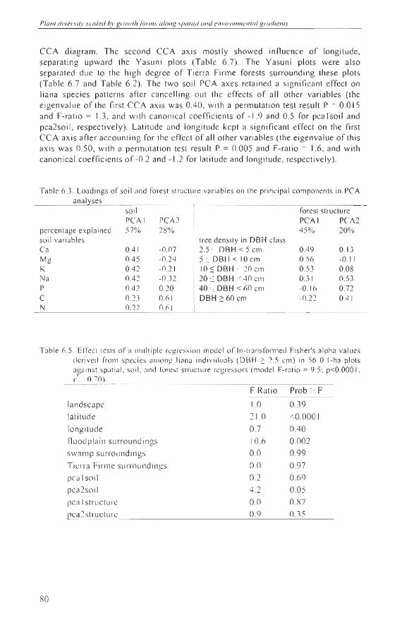
A rair amount (70%) of' the variation in Fisher's alpha was explain ed by the regress ion model (Table 6.5). Lat itude yielded the strongest erfect on Fisher's alpha (while keeping constant the other effects), showing that diversity peaked in the Peruvian area in compari son wi th the Ecuadorean and Colombian s iles. Local plot surroundings of floodplains as well as swampy soi ls (the second PCA axis ofthe soi l data) negatively inlluenced liana diversity .
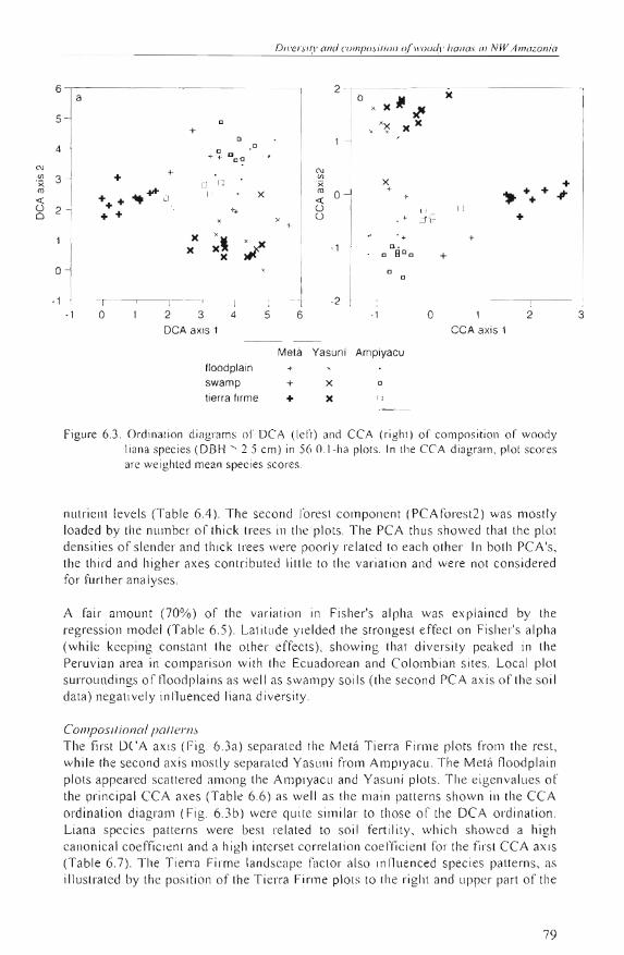
Composifional paflerns The first DCA axis (Fig. 6.3a) sepa rated lhe Metá Tierra Firme plots frolll the rest, while lh e second axis mostly separaled Yasuni from Ampiyacu. The Metá floodplain plots appea red scattered alllong the Ampiyacu and Ya su ni plots. The eigenvalues of the principal CCA axes (Tab le 6.6) as well as the main patterns shown in the CCA ordination diagral1l (Fig. 6.3b) were quite sim ilar to those of the DCA ordination . Liana species patterns were bes t re lated to so il fertility, which showed a high canonica l coeffi cien t and a high interset co rrelation coefficie nt for the first CCA axis (Table 6.7). Tl1e Tierra Firme landscape factor also influenced species patterns, as illustrated by the position of the Tierra Firme plots to the right and upper part of the
79
3
Planf divel"sif)' .'caled by groll'fh 101"1/1.' olong .'pafiol ond e l1l'itw/IIu!I1/(JI gmdienfS
CCA di agram. The second CCA axis mostl y showed influence of longitude, separatin g upward the Yasllní plots (T ab le 6. 7) . The Yasuní plots were also
separated due to the high degree o f T ierra Firme forests surrounding these plots
(Table 6.7 and Table 62). The two soi l PC A axes retained a significant effec t on
liana species patterns after cance lling out the effec ts 01' all other variables (the
eigenvallle of the first CCA axis w as OAO, with a permutation tes t re sult P = 0.015
and F-ratio = 1.3, and with canoni ca l coe ffi c ients of -1. 9 and 0.5 for pca l soil and
pca2so il , respectively). Latitllde and longitllde kept a signifi cant effect on the first CCA ax is after account in g for the effec t of all o ther variab les (the eigenvalue ofthi s
axi s was 0.50, w ith a permutation test result P = 0.005 and F-rario ~ 1.6, and wirh
canonical coeffi c ien ts of -0.2 and -1 .2 fo r lat itude and longitude, respec t ive ly) .
Table 6.3. Loadi ngs of so il (l nd fo rest structll re variables 0 11 th e pr incipal componen ts in PCA analvses
per-centage explained süi l variables Ca Mg K Na P e N
so il peAl 57%
0.41 0.45 042 OA2 OA2 0.:23 0.22
reA 2 28%
-0.07 -0.24 -0.21 -0.32 0.20 O.ól O.()I
rorest structure PCA I pe A 2 45% 20%
tree density in DBl-l class 2.5' DBH < 5 cm OA9 0. 13 5 :: DBII < 10 cm 0.56 -0.11 10::: DBH · :Wcm 0.53 0.08 20 ::: DBH < ·10 cm 0.31 0.53 40 ::; DBH < óO cm -0 . 1 Ó 0.72 DBH 2: 60 cm -0.22 OAI
Table 6.5. EITect tests 01' a 1l111l tipl e rqi! ress ioll model 01' In-transfolTlled Fisher's alpha va lues der'ived I'rol11 spec ies umong liallJ individua ls lDB H 2: 2.5 cm) in 56 O. I-ha plots against spatial . soil. alld l'ore,t structure regressürs (mode l F-ratio = 9.5; p<O.OOO 1; ¡-,' ' (1.702.
F Rat ió Prob > F
landscape 1.0 0.39
latitude 2 1.0 < 0.000 I
longi tllde 0.7 OAO Dood plain surround ings 10.ó 0.002
swam p surroll ndin gs 0 .0 0 .99
Ticrra Finne su rl'OlI nd ings 0.0 0.97
pea 1 soil 0.2 0.69
pca2soi I 4.2 O.OS pca I strlleture 0 .0 0.R7
p ca2struetllrc 0.9 0.15
RO
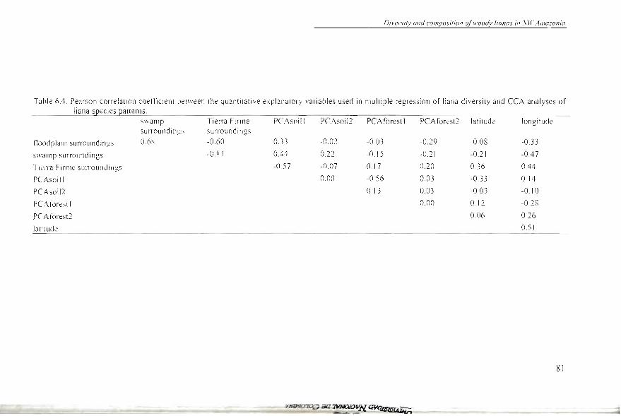
Dil'ersiry al7d composir io l7 ofll"Oody lianos ill ,vll' Amazonia
Tahle 6A. Pearson correlati on coe ffície nt be tween the quantitati ve explanatory va ri ables used in multiple regressi on of liana diversity and CCA analyses of liana spec ies patterns.
s ~"arnp TielTa Firme PCAsoi l l PC Asoil 2 PCAforesll PCAforest2 latitude longit ude surrou ndings surroun dings
fl oodp la in sUlTound in g:; O.6 ~ -0.60 0.3 3 -0.02 -0 .03 -0.29 -0. 08 -0.33
swamp surround in gs -O. s;. ~ OA4 022 -0.15 -0.21 -0.2 1 -DA 7
Tié'na Firme surrou ndi ngs -0 .57 -0.07 0.17 0.20 0.36 OA4
PCAso i11 0.00 -0.56 0.03 -0.3 3 0. 14
PC Asoil2 0.13 0.03 -003 -o. 1 O
r CArorest 1 0 00 0.12 -0.28
PCAt0r.:s t:2 0.06 0.26
lati tudt: 0.51
81
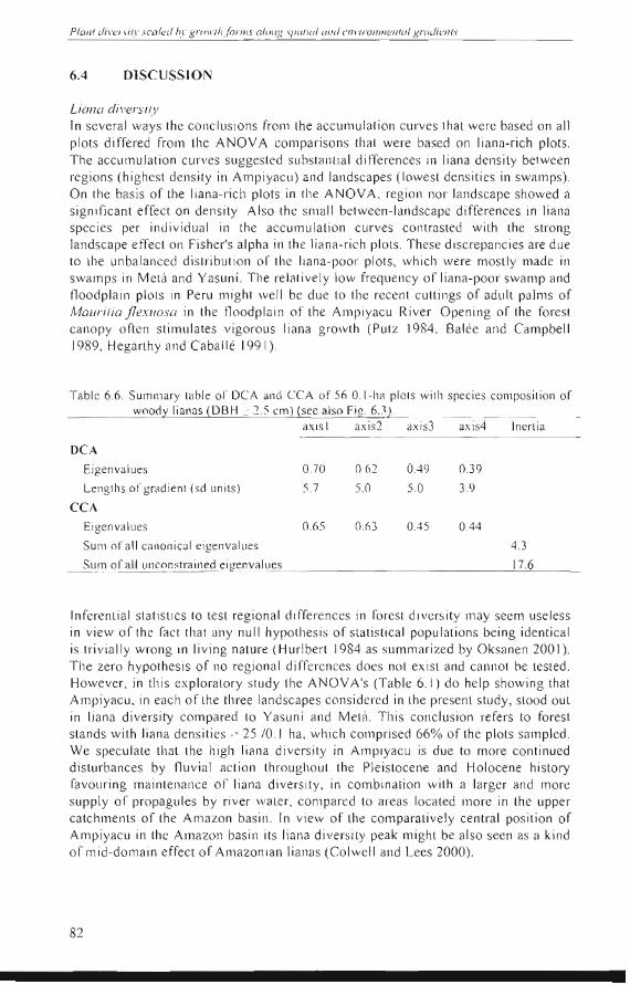
6.4
82
Planl divenily sealed hl ' gl'() " 'lh(ol'llls a/cmg 1/lOliol Ol/eI elll 'il'Ollll1en/o l gmdiel1ls
DlSCUSSJON
Liano dil'ersily Tn severa l ways the concl usions frOIll the accumu lalion curves that were based on aH pl ots differed from lhe ANOV A cOlllpari sons lhal were based on liana-ri ch plots, The accumulation curves sugges led substanti al differen ces in liana density between reg ions (highes l dens ity in Ampiyac ll) and landsca pes (Iowest densiti es in swamps), On the basi s of the li ana- ri ch plolS in the ANOV A, reg ion nor landscape showed a significant effec t on dens ity, Also the sma ll be tween-Iandscape differences in liana species per indi vidua l in the accumulati on curves con trasted with the strong landscape effec l 0 11 Fisher's alpha in the li ana-rich pIOIS, These di sc repancies are due to the unbalanced di slribut ion of the liana-poor plots, which were mosLl y made in swam ps in Metá and Yasuní , The relati vely low frequency of liana-poo l' swamp and fl oodplain plots in Peru Illi ght we ll be due lo lhe recent cutlings of adlllt palms of Maurilia flexuosa in lh e floodpl ain 01' lhe Ampiyacu River. Opening 01' lhe forest ca nopy often stimul ates vigorous li ana gro"'th (Putz 1984, Balée and Campbell 1989, Hega rthy and Caba ll é 1991),
Table 6,6, Summary table 01' DC A and CCA of 56 0, I-ha pl ots with species cOlllpos ition of wood)' lianas (DBH / 2,) cm) (see al50 Fig, 6,1).
mus 1 axi s2 ax isJ axis4 Inert ia
DCA
Eigenva lues 0,70 0,62 0.49 0,39
Lenglh s 01' gradient (sd unilS) ),7 5,0 5,0 3,9
CCA
Eigen valu es 0,65 0,6 3 0.45 0.44
SUI11 ora ll canoni ca l eigenvalues 4,J
Sum of a l1 un constrain ed eif envalu es 17,6
Tnferenl ia l slalis ti cs to les l regional differences in fo rest divers ity may seem use less in view 01' the fac! that any nu ll hypo!hes is of slatisli ca l popul atiol1s being ide ntica l is trivia ll y wrong in li ving nature (Hurl bert 1984 as summa ri zed by Oksa nen 200 1), The zero hypothesis of no regional differences does nol exisl and ca nnot be tested, However, in thi s ex ploratory study lhe ANOV A's (Tab le 6, 1) do help showing that Ampiyacu, in each 01' the three land scapes considered in lhe present study, stood oul in liana divers ity com pared lo Yasuní and Melá, This conclusion refers to fores t stands with li ana dens it ies > 25 /0,1 ha , which cOlllpri sed 66% of the plots sampl ed, We specu late that lhe high li ana diversity in Ampiyac u is due to more continued disturbances by flu vial ac tion throughoul the Pl eistocene and Holocene hislory favouring mai nlenance 01' li ana diversity, in combi nalion with a larger and more suppl y of propagules by ri ver waler, cOlllpared lO areas loca ted more in the upper ca tchmenlS of the Amazon basin, In view of lhe comparaLi ve ly cenlral pos iti on of Ampiyacu in lhe Amazon bas in its liana di ve rsity peak mi ghl be also seen as a kind ofmid-domain effect 01' Alllazonian lianas (Colwe ll and Lees 2000) ,
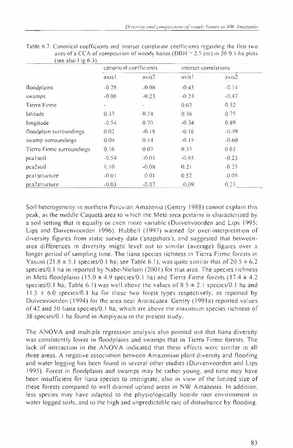
Table 6.7. Canonieal eoeffie ients and interset eorrelation eoetTíeients regarding Ihe f'írst two axes of a ceA of compos ition of woody lianas (OBH '> 2.5 elll) in 56 O. I-ha plOls (see also li" 6.3 l.
canonical eoeffieien ts interset correlati ons
axis 1 axis2 axis 1 axis2
floodplains -0.2R -0.08 -0.45 -0. 14
swamps -0.06 -0.23 -0.24 -0.4 7
Ti erra Firme 0.ó2 0.52
latitude 0.37 0.24 0.36 0.75
longitude -0.54 0.7 0 -0 .34 0.89
floodplain surrounci ings 0.02 -0.1 X -016 -0.49
swamp surro undings 0.0<;1 0.14 -0 . 15 -060
Tierra Firme surroundings O.ló 0.07 0.37 0.63
pea 1 soi l -0.54 -0 .05 -O.X5 -0.23
pea2soi l 0. 10 -O .O~ 0.21 -0.25
pea 1 struetu re -0.01 -0.01 0.52 -0 .05
pca2strueture -0.03 -0.07 -0.09 0.2 3
Soil heterogeneity in northern Peruvian Amazonia (Gentry 198 8) ca nnot explain thi s peak, as the middle Caquetá area to which the Metá area pertains is characterized by a so iJ setting that is equally or even more variable (Duivenvoorden and Lips 1995; Lips and Duivenvoorden 1996). Hubbell ( 1997) warned for over-interpretation of diversity figures from sta tic survey data Csna pshots' ), and suggested that betweenarea differences in diversity might leve l out to simi lar (ave ra ge) figures over a longer period ofsampling time. The liana species richness in Tierra Firme forests in Yasuní (21.8 ± 5. 1 spec ies/O. J ha; see Table 6. 1), was qu ite sim i lar that of 20.5 ± 6.2 species/O.l ha in reported by Nabe-Nielsen (2001) for that area. The spec ies richness in Metá floodpl ains ( 15.0 ± 4.9 spec ies/O. l ha) and Tierra Firme forests (17.4 ± 4.2 species/O.I ha; Table 6.1) was we ll aboye the values of 8.5 ± 2.1 spec ies/O.l ha and 11 .5 ± 6.0 species/O.! ha for these two rorest types respectively, as reported by Duivenvoorden (1994) for the area near Araracuara. Gentry ( 1991 a) reported values of 42 and 50 li ana species/O. 1 ha , which are aboye the maximum species richness of 38 spec ies/O. I ha found in Ampiyacu in the present sludy.
The ANOV A and multiple regression analysis also pointed out Ihat liana diversity was consistently lower in fl oodp lains and swamps that in Tierra Firme forests. The lack of interaction in Ihe ANOVA indicated that these effects were similar in all three areas. A negative assoc iation between Amazonian plant diversity and flooding and water logging has been found in severa l other studies (Duivenvoorden and Lips 1995). Foresl in floodplains and swamps may be rather young, and time may have been insufficient for liana species to immigrate, also in view of the limited size of these forests compared to well drained upland areas in NW Amazonia. Jn addition, less species may have adapled lO Ihe physiologically hoslile rool environmenl in water logged soils, and lo the high and unpred ictable rate of dislurbance by flooding .
83
84
Plan / diversi/y >u¡/c(/ 1'.I 'I!./'I} II'ih jili'll7.1' o long sl'Clliol 01/{1 c I/I'/l"Onll7en /Cl I gl'Cldicl//s
Despite the strong d iffere nces in so il fertility between Yasuní and Metá (Table 6.2 ), the average plot den si ty and d ivers ity of lianas did not di ffe r su bstantially between th ese areas. The laek of di fferen ce in li ana diversi ty between these two areas lead to th e insigni fican t ro le of the soil fer tility fac tor in the mlll tip le regress ion of Fisher's alph a. Our results, th erefore, do not suppo rt the notion th at so il fertility is re levant for liana abundance (Ibilrra-Manríquez and Martínez-Ramos 2002), as has been suggested in ea rli er sludies (PUIZ and Chai 198 7, Ge ntry 199 1a). In thi s way, li anas respond differently to so il ferlility than trees (DBH > 2.5 cm) in the three study sites. Duiven voorden el al. (in press) reported signiticant hi ghe r thin tree densities in Metá com pared to both Ampiyacu and Yasuní , ilnd sllggested that thi s mi gh l be due to inc reased longevity and better defense mechanisms aga inst herbivory on less fertil e so il s in Metá. The fall ing down of host trees 01' lianas because of the liana weight, c lonal reproduetion and effec tive dispersal by wind Illi gh t prov ide means by whi ch li anas successfull y es tablish and main ta in levels of stem dens ities in a way that is independe nt from soi l fer tilit y.
Liana species pallerns Soil fel1ility was the most import an t faclor in th e ca nonica l ana lysis of liana spec ies pat terns and exp laim:d lhe distinct composilion of the Tierra Firme plots of Metá com pared to the forest in other land scapes and areas. Soi ls in the Metá Tierra Firme plots showed disti nc ti vely lower reserves of catio ns and P, tha n so il s from th e other two areas, Lips and Duivenvoorden (1996) sugges ted th at the low leve ls of the so il nutrien t rese rves in uplands from the middle Caquetá area were due to the highly wea thered status 01' the soil paren t ma terial tha t orig inated fro m the Guayana shield area (H oo rn 1994), In the middl e Caquetá basin, j us t as part ofthe Ri o Negro bas in of Venezuela and in well-d rained upland rorests of" low land Bomeo (Ashton 1989, see also Potts el al. 2002), so il s wit ll slIch 10\\1 nu tri ent reserve levels are covered by thi ck and ac id humus pmfilcs, These are probably a rcsull of lower litter decompositi on (Lips and Duivenvoorden 1996), and more elosed nulri enl cyc ling (Baillic 1989, Burnh am In9) and associatcd mechani sms 01' null'ient conservation (lorda n 1985) complHed to rorests on mO I"e nutrient ri ch so il s. In th e wide spati al contex t and th e geologicillly lo ng time during whic h these soi l differences have occu lTed in the Amazo n basin, it is conceivab le th il t li ana species have ada pted differentially to such soi l differences.
The second im pol1ant I"acto l' explai nin g liana species pattellls was long itude 0 1'
proximity to the Andes, mostly separating Yas uní from the othe r two areas. Thi s longitudinal factor is poorly correlaled to so il fe rtili ty (Table 6.4) due to lh e comparalively high so il minerill concentralions in Ampiyacu (Tabl e 6.2). This res ull shows that generali zati ons of increased soil fertility in lh e vicinity of the foolslope zone of the Andes cOl1lpmed to more castern ilreas in the Amazon bas in are not pcrm ittecl Gent ry (1986, 1990) reponed migrati on of Andean flo ral elemen ts in to wet lowland forcsis 01' Chocó and ( entra l Amcrica. Perha ps the dis ti nc t asse mbl age of lianas in Yasuní compared to Amp iy::tcu and Metá is due to a relati vely high and recent influx rrom Andean liana tax a fl'om the nea rby Andes ,

Chapter 7
RESPONSE SHAPE OF PLANT GENERA AND SPECIES ALONG GRADIENTS IN NW AMAZONIA
Alva ro J. Duque M., Joost F. Duivenvoorden , Jaime Cavelier, Alberto García, César Grández, Manuel Macía, Hugo Romero-Saltos, Mauricio Sánc hez and Renato
Va lenc ia Subm ilted lO Journol 01 Vegefofion Science
Response slwpe o(plan / genero am! s!'(!cies along gradien/s in NW Amazonia
7.1 INTRODUCTION
A commonly accepted idea in plant ecology is that species responses to environmental gradients have a Gaussian shape with the optimum located at a particular point along an environmental gradient (Gauch and Withaker 1972). A symmetrical unimodal response shape has been the only ecological model for which parameters can be well estimated (ter Braak and Looman 1986). A basic assumption in Niche theory is that both fundamental and reali zed niches have symmetrical Gaussian curves (Austin 1999). However, the use of such a symmetrical response model as a paradigm in ecological modelling has been strongly criticized (Austin and Meyers 1996, Austin 2002). The continuum concept, which maintains that species response curves have different shape, amplitudes, widths and optima along environmental gradients (Austin 1985), has gained support in recent years. Biological interactions and factors such as dispersal , competition, succession, disturbance and pest pressure could modify the species response into non-Gaussian shapes along these gradients (A ustin el a/. 1990, Guisan and Zimmermann 2000). Indeed, biotic processes are rarely considered in statistical models of species distributions and need further attention (Condit 1996, Austin 2002).
Although several ways of testing skewedness and analyzing the response shapes of species along gradients have been employed, few methods provide sufticiently accurate results (Oksanen and Minchin 2002). Sorne of the most common problems (Oksanen and Minchin 2002) are unrealistic shapes of polynomial functions (Austin el al. 1990), bias and subjective judgment in methods that are based on visual analysis (Okland 1986) and in smooth generalized additive models (GAM , Hastie and Tibshirani 1990), as well as confusion in thelocation of the maximum in beta functions (Austin el al. 1994, Oksanen 1997). However, a set of tive hierarchical models, which range from flat to skewed and inc1ude symmetrical responses as proposed by Huisman el a/. (1993), appear to give more success in solving parametric questions of response shapes (Oksanen and Minchin 2002). Ihis set of equations could be applied to different environmental gradients as long as the models are only used for descriptive purposes (Huisman el al. 1993).
Species are the most common hierarchical taxonomic unit employed to analyze response shapes (Minchin 1989, Austin and Meyers J996, Lawesson and Oksanen 2002). Individual species analyses might help to understand plant community structure, and so, how to tind mechanistic explanations for existing patterns (Minchin 1989). In NW Amazonia still only a few studies have focused on the behaviour of individual species along environmental gradients (i.e. Duivenvoorden and Lips 1995, Svenning and Balslev 1997, Svenning 1999, Tuomisto el al. 1998, Phillips el al. 2003). In ecological inventories, a high proportion of species occurs with very few individuals (Pitman et al 1999), which appears as a constraint to get data sets of sufticient size to analyze species response curves. Therefore, a higher taxa as genus provides a good alternative to overcome the sample error in tropical inventories. Genera-based analyses , might help to understand better the role of environment-vegetation interactions at wider temporal and spatial scales, such as those included in paleoecological studies (Hooghiemstra and van der Hammen 2000, Colinvaux 1987).
89
Planl diversify scoled hy ?,FOIt 'fh fonns along spufio! une! enl '¡ronmenfal g l'odien fs
The goal of this study is to analyze the distribution and response curves of selected genera and species along abstract complex ecological gradients in NW Amazonia forests. The following hypotheses are considered: (1) Genera and species respond to complex environmental gradients, such as those derived from ordination analysis, with a symmetrical Gaussian function; (2) The response shape of individual species and genera along a soil gradient is similar to that found along a complex gradient that is constructed by ordination of complete inventory data of species or genera. If the tirst hypothesis is accepted, niche-preemptioning prevails and may be accepted as the dominant model for woody species in NW Amazonia; if not, continuum model is accepted as the most suitable one. Tfthe second hypothesis is accepted, soil fertility should be employed to predict species distribution along more complex environmental gradients in NW Amazonia; if not , that would indicate the importance of other factors like biotic ones.
7.2 METHOOS
SIl/dv sile and sample design The study was carried out in three different areas in north-western Amazonia: (1) the Metá area, which forms part of the middle Caquetá basin in Colombian Amazonia; (2) the Yasuní area in Amazonian Ecuador; and (3) the Ampiyacu area pertaining to the Maynas Province in Peruvian Amazonia (Figure 6.1). AII areas are in the Humid Tropica l Forest life zo ne (bh-T) according to I-Ioldridge el al. (1971). The average temperature is near 25°C , and allnual precipitation oscillates around 3000 mm. AII months show an average prec ipitation aboye 100 mm. In Metá and Yasuní the lowest rainfall is in January and February, whereas in Ampiyacu this occurs in August and September (Lips and Duivenvoorden 200 1).
A total of 80 O.I-ha plots were established; 30 in Metá and 25 in both Yasuní and Ampiyacu. Plots were located and distributed across the main landscape units as follows: 31 in Tierra Firme or well drained upland areas (15 in Metá , 10 in Yasuní, and 6 in Ampiyacu); 22 in well drained floodplain s (5 in Metá, 8 in Yasuní, and 9 in Ampiyacu) ; 22 in swamps (5 in Metá , 7 in Yasuní, and 10 in Ampiyacu) and 5 in white sands (only sampled in Metá). A detailed description of each of these landscape units can be found in Lips and Duivenvoorden (2001). In order to establish the plots, starling locations and the direction of the tracks by vvhich the forests were entered were determined on lhe basis of lhe interpretation of aerial photographs (Duivenvoorden 200 1) and satellite images of Landsat TM (Tuomisto and Ruokolainen 200 1) . During the walk through the forests, soils and lerrain units were rapidly assessed, and forests were visually examined. In this way, sites with homogeneous soils and physiognomically uniform forest stands were identitied. In these sites, rectangular plots (mostly 20 x 50 m) were delimited by compass, tape and stakes, working from a random starting point, with the restriction that the long side ofthe plot was parallel to the contour line. Plots were located without bias with respect to floristi c composition or forest structure (including aspects of tree density, thickness and height, and presence of lianas) . They were made in forest that lacked signs ol' human intervention. The only exceptions to thi s were some of the swamp plots in the floodplain of the Ampiyacu River in Peru, where palms had recently been cut to harvest fruits from Mauritia flexuo sa. Plots were established at a minimum between-plot distance of 500 m and were mapped with GPS. Plots were
90
Respunse .\hape o/plalll generu unel species olong gl'lldiel1/s in NW AlI1ozol1ia
subdivided into sllbplots of IOx 10m, in which all vascular plant individuals with DBH~2.5 cm were nllmbered and measured with tape. Fieldwork took place in 1997 and 1998.
Botanical coJlections were made of al! species (DBH~2.5 cm) found in each plot. Identificatíon took place at the herbaria COAH, QCA, QCNE, AMAZ, USM , MO, NY and AAU (Holmgren et al. 1990). The nomenclature of families and genera followed Mabberley (1989). Within fam ilies, or grOllps of closely allied families, specimens that could not be identif¡ed as a species beca use of a lack of sufficient diagnostic characteristics were clustered into morpho-species on the basis of simultaneous morphological comparisons with all other specimens. Hereafter the term 'species' refers to both morpho-species and botanical species.
In the central part of each plot, a soil augering was carried out to 120 cm depth in order to describe the mineral soil hori zons (in terms of colour. mottling, hori zon boundaries, presence of concretions, and textllre) and to define soll drainage (in classes ofFAO 1977). At each augering a soil sample was taken at a depth of65-75 cm. For analyses, soil samples were dried at temperatures below 40°C, crumbled and passed throllgh a 2-mm sieve. The total content of Ca, Mg. K, Na, and P was determined by means of atomic emission spectrometry of a subsample of 100-200 mg from the sieved fraction, that had been diges ted in a solution of 48% HF and 2M H2S04 (after Lim and Jackson 1982). Total content of C and N was determined for the sieved fraction by means of a Cario Erba I 106 elemental analyser. Soil analyses were done at the so il laboratory of 1nstitute fo r Biodiversity and Ecosystem Dynamics ofthe Universiteit van Amsterdam.
Data ana/ysis Three standardized gradients or coenoclines (Lawesson and Oksanen 2002) were employed in analysis of the response shapes of genera and species. (1) The first axis from a detrended correspondence analysis (DCA) based on presence-absence of all species (2157). (2) The first axis from a detrended correspondence anaJysis (DCA) based on presence-absence of all genera (527). Both these gradients represent a complex environmental and spatial gradient determining the distriblltion of either genera or species. (3) The first axis from a principal component analysis (PCA) of soil elemental concentrations (Table 7. 1). DCA was performed with CANOCO 4.0 (ter Braak and Smilauer 1998) using default options (Lawesson and Oksanen 2002). PCA was carried out by means of JMP 3.0, based on the correlation matrix of logarithmically transformed variables. Al! analyses were done on the basis of the data from 80 plots made in all landscapes and 31 pJots made in Tierra Firme forests.
Response modefs Following the criteria of minimum frequency proposed by Oksanen and Minchin (2002), in all landscape units, 89 genera and 24 species that were present in 25 or more plots were selected for the analyses. In onJy Tierra Finne, 41 genera and 8 species that were present in 20 or more plots. were employed in the analyses. For description of genera and species response shapes the hierarchic models proposed by Huisman el al. (1993) were employed by using the HOF program which maximizes a log-likelihood function instead of minimizing the squared resi dllals , and by considering presence-absence data or binomial with denominator m = I (Oksanen
91