Embed Size (px)
Citation preview

APPENDICES
APPENDIX C
PROJECT STEERING COMMITTEE

C - 1
APPENDIX C1-1: PROJECT STEERING COMMITTEE
STUDY FOR SOCIO-ECONOMIC RECONSTRUCTION AND DEVELOPMENT OF CONFLICT-AFFECTED AREAS IN MINDANAO
First Interim Steering Committee Meeting April 11, 2007, 10:30AM – 2:00PM
Kapayapaan Room, OPAPP
Highlights and Matters Arising from the Meeting
I. Meeting Objectives and Attendance
1. The meeting primarily aimed to present and discuss the status of the formulation of the
Inception Report of the project, entitled “GOP-JICA Study for Socio-Economic Reconstruction and Development of Conflict-Affected Areas in Mindanao (SERD-CAAM)” to the members of the Project’s Steering Committee. Attached as Annex A is the meeting agenda.
2. The meeting was chaired by Secretary Jesus G. Dureza of the Office of the
Presidential Adviser on the Peace Process (OPAPP) and co-chaired by Dr. Abas Candao, Chairperson of the Bangsamoro Development Agency (BDA).
3. Other attendees include Ambassador Ryuichiro Yamazaki of the Embassy of Japan
(EOJ); Resident Representative Shozo Matsuura of the Japan International Cooperation Agency (JICA); and other representatives from OPAPP, BDA, EOJ, JICA Philippines, JICA Study Team, National Economic and Development Authority (NEDA), Department of Agrarian Reform (DAR), Department of Agriculture (DA), Department of Interior and Local Government (DILG), Department of Environment and Natural Resources (DENR), Mindanao Economic Development Council (MEDCo), GRP-MILF CCCH, and the International Monitoring Team (IMT). Attached as Annex B is the complete list of meeting attendees.
II. Highlights and Matters Arising from the Meeting
4. Secretary Jesus Dureza welcomed the interim members of the Project’s Steering Committee and presented the overview of the meeting, as follows: • Presentation of the overall Japan-Bangsamoro Initiatives for
Reconstruction and Development (J-BIRD); • Presentation and discussion on the status of the drafting of the Socio-
Economic Reconstruction and Development of Conflict-Affected Areas in Mindanao (SERD-CAAM) project’s Inception Report;
• Presentation and discussion of the proposed Project Implementing Mechanism; and
• Endorsement and next steps. 5. Sec. Dureza emphasized the role of the Steering Committee (SC) as the policy body
that would set the direction and guide the Project in proceeding with its next steps. He added that the SC also serves as the venue among project implementers to share experiences on the ground.

C - 2
6. Moreover, Sec. Dureza expressed that while infrastructure development is important, the SERD-CAAM project must not set aside activities concerning conflict management and peace building under the Project. He said that the Study must not overlook the role of local government units (LGUs) and the community in the consultation process, as well as in project implementation.
7. He further mentioned that convergence with other donor agencies must be undertaken
and added that the end goal of the Project is to further build relations with the MILF. 8. In his remarks, Dr. Abas Candao, BDA Chairperson pointed out that the project’s SC
and Technical Working Group (TWG) should support and facilitate effective implementation of the Study.
9. Dr. Candao recalled that the BDA first requested assistance for the formulation of the
Comprehensive Bangsamoro Development Plan and the Embassy of Japan immediately responded through the implementation of a two-year SERD-CAAM. He then emphasized the needed participation and support from the Project’s support mechanisms towards the BDA’s formulation of their Bangsamoro Comprehensive Development Plan.
10. Dr. Candao also thanked the OPAPP for all its support given to the BDA.
11. Ambassador Ryuichiro Yamazaki of the Embassy of Japan welcomed all participants in
the meeting. He recognized that needs on the ground are limitless and priorities can be considered as immediate and long-term. He then added that considering this, it is a challenge on how to efficiently utilize the limited resources/funds given by the Japanese Government for this Project.
12. Ambassador Yamazaki also pointed out the need to increase the number of
stakeholders in Mindanao and combine all channels together in the learning process while preparing for the signing of the peace agreement.
13. In his remarks, Resident Representative Shozo Matsuura of the JICA Philippines
raised the concern on how to consolidate development efforts in Mindanao given the involvement of its various stakeholders. He then admitted that too many stakeholders involved in addressing Mindanao issues could lead to confusion. However, he informed the participants that the JICA Study Team will further explain on how to deal with the issue on the involvement of many stakeholders in Mindanao.
14. Sec. Dureza responded that the presence of various Mindanao stakeholders would
explain the uniqueness of the island-region. He added that with this unique feature, people who work in said area should have full knowledge and should have good background on the dynamics of Mindanao.
15. Mr. Eiichi Oshima, Deputy Chief of Mission of the Embassy of Japan, updated the
group on the status of the overall assistance of the Japanese Government to the Mindanao peace process through the Japan-Bangsamoro Initiative for Reconstruction and Development (J-BIRD). He informed the participants that Japan’s Grant Assistance for Grassroots Human Security Projects (GGP) given to NGOs supportive of the BDA is ongoing covering 12 grant contracts and amounting to more than US$624,000 or PhP31.2million. He said that these projects include construction of school buildings, post-harvest facilities, livelihood training center for Bangsamoro women, and potable water systems, which will be completed in May 2007.
C - 3
16. Tsuneo Bekki, JICA Study Team Leader, presented the overall outline of the study as well as the status of the formulation of the Inception Report and tentative dates for presenting said report to various stakeholders.
Mr. Hussein Lidasan, JICA Study Team member, presented the method and expected outputs of the planned assessment for target areas. Mr. Koichi Motomura, JICA Study Team member, gave an overview of the proposed method and coverage of the in-depth barangay profiling and needs analysis. Mr. Makoto Usami, JICA Study Team member, presented the objectives and criteria for selection of areas and projects to be implemented under the Quick Impact Project (QIP) scheme alongside the conduct of the Study. Attached as Annex C is the presentation material of the JICA Study Team
17. Sec. Dureza suggested that with the diverse composition of Mindanao, it is deemed important to include a peacebuilding and conflict management specialist/consultant in the Study Team. He also added the need to mainstream LGUs on the ground, working with the Study Team.
18. Mr. Bekki responded that they have no person in the team who specializes in conflict
management, but they are relying on the information given by the OPAPP and the IMT.
19. Sec. Dureza further raised the importance of sharing existing data gathered after the Study as input to the ongoing convergence effort of Mindanao, as well as to take note of the Project’s sustainability plan.
20. Sec. Dureza also raised the possibility of adopting barangays, municipalities, and
provinces in the delivery of assistance under the Study. He then raised the issue of moral hazard in providing assistance to vulnerable areas, specifically the concern on areas, which are not conflict-affected but are very poor, like the case of the Caraga Region. He suggested that in order to address this issue, the project may consider benchmarking efforts in the northern part of Mindanao, specifically in Caraga.
21. Sec. Dureza further raised the issue on communications/connectivity, specifically during conduct of interviews and consultations by Japanese consultants in the community. He suggested that the presence and involvement of the BDA and other concerned local players during conduct of said activities on the ground should be ensured.
JICA Study Team to field a consultant/specialist on peacebuilding and conflict management in the conduct of the Study, as well as ensure involvement of concerned LGUs during consultations and project implementation.
JICA Study Team and TWG to explore possibility re “adopt a barangay/municipality/province” concept and benchmarking efforts in the northern part of Mindanao, specifically in Caraga under the Study.
JICA Study Team and TWG to ensure the presence and involvement of the BDA and other concerned local players during conduct of community consultations and interviews.

C - 4
22. Mr. Hussein Lidasan informed the group that the JICA Study Team has already started coordinating with donor and government agencies in Mindanao, like MEDCo and NEDA and they plan to talk with the BDA re involvement of local players in their activities.
23. Sec. Dureza then emphasized the overall objective of this GOP-GOJ effort, which is to
build relationships with the MILF and communities affected by conflict through the implementation of the SERD-CAAM.
24. Ambassador Yamazaki raised the concern on how to get political support through
socio-economic measure, as well as on the prioritization criteria for the selection of barangays that will receive quick impact projects (QIPs). He suggested that the JICA Study Team to closely work with OPAPP on the selection of barangays as recipients of the QIPs.
25. Ambassador Yamazaki further raised on how to relate the methodology of the Study to its overall support to the peace process and ensure that there is no extreme dissatisfaction among concerned groups (i.e. leaders, women, youth).
26. Dir. Ryan Sullivan recommended the inclusion of a capacity building component under
the Project for the BDA as an institution in order to further strengthen their capabilities in implementing projects.
27. Dr. Fermin Adriano raised three (3) main points about the conduct of the Study,
namely: 1) database requirement; 2) the nature of the participatory approach; and 3) framework used by the Study.
28. On the database issue, Dr. Adriano inquired on its value-added feature given the
existing, as well as past socio-economic studies done in Mindanao by other groups, such as the Growth with Equity in Mindanao (GEM), the World Bank Joint Needs Assessment (JNA), and the JICA Study on the ARMM in 2004. He then strongly recommended that the JICA Team to extensively provide a review of literature in the conduct of the Study.
29. On the participation approach applied by the Study Team, Dr. Adriano suggested that it
should be very clear.
30. On the framework used by the Study Team, Dr. Adriano suggested to include the process on how to approach the issue on peace and conflict, as well as on peacebuilding.
31. Dr. Adriano also recommended that after the formulation of the Review of Literature, a
clear framework should be crafted as the basis in identifying on the spot assistance and quick impact projects for communities.
32. Prof. Rudy Rodil suggested for OPAPP to ensure making adjustments in implementing
culturally sensitive initiatives under the SERD-CAAM.
JICA Study Team to closely work with BDA and OPAPP on the selection of barangays as recipients of the QIPs.
JICA Study Team to provide an item on Review of Literature as part of the Study.

C - 5
33. Dir. Lourdes Lim of the NEDA suggested for a review on the list of barangays covered by the Study. She also suggested the inclusion of the following cities under the Study: 1) General Santos; 2) Kidapawan; and 3) Cotabato.
34. Dir. Lim further raised the need to consolidate indicators and the roots of conflict as
part of peacebuilding work. She said that the database as one of the outputs of the Study should be evidenced-based as basis for analysis.
35. On the delivery of on the spot assistance, Dir. Lim said that it should be expanded to
beneficiaries who shall also be responsible for its effective implementation, as well as its sustainability. Thus, ensuring stakeholders’ or communities’ ownership of interventions to also avoid duplication of efforts and to encourage convergence.
36. On the framework used by the Study, Dir. Lim observed that there are sectoral themes
applied. She then suggested to emphasize on the infrastructure sector, specifically to focus on inter-modal transport/trade not only with intra-Mindanao coverage but also through the Brunei, Indonesia, Malaysia, the Philippines – East ASEAN Growth Area (BIMP-EAGA).
37. Assistant Secretary Evelyn Florina Daplas of OPAPP presented the overall structure
and functions of the Project Steering Committee (PSC) and the Technical Working Group (TWG), while BDA Chairman Dr. Candao gave an overview of the anticipated BDA roles/functions vis-à-vis the conduct of the Study. Dir. Lim briefed the group on the next steps that the JICA Study Team, the PSC and the TWG should pursue relative to the implementation of the Study and the establishment of support mechanisms. Attached as Annex D is the presentation material on the implementation mechanism and the next steps.
38. The meeting approved the official constitution of the Project Steering Committee and
Technical Working Group, as well as the implementation structure with the note that it shall be open for adjustments as the Project progresses.
39. The meeting also endorsed immediate next steps of the Project presented by Dir. Lim.
It was then agreed that membership of agencies at the Steering Committee should be at the senior level since it is the highest policy making body of the Project.
40. In his closing remarks, Resident Representative Matsuura emphasized that on the spot
projects will serve as entry point towards the implementation of QIPs. 41. Dr. Candao also thanked all major players that initiated the SERD-CAAM, as well as
for endorsing greater participation of the BDA in this undertaking. 42. Ambassador Yamazaki commended the good work of all partner agencies involved in
the Project. He said that through the involvement of a socio-economic expert in the IMT, everybody can work on the gains of the peace process.
43. Sec. Dureza emphasized in his closing remarks that in the implementation of SERD-
CAAM, agencies involved are expected to provide quick action on the delivery of assistance without short circuiting the implementation process.
44. The meeting adjourned at 2:30PM.
C - 6
STUDY FOR SOCIO-ECONOMIC RECONSTRUCTION AND DEVELOPMENT OF CONFLICT-AFFECTED AREAS IN MINDANAO
Second Interim Steering Committee Meeting October 19, 2007, 2:30AM – 4:00PM
Kapayapaan Room, OPAPP
Highlights and Matters Arising from the Meeting
I. Meeting Objectives and Attendance
1. The meeting primarily aimed to present and discuss the status of the study on Socio-
Economic Reconstruction and Development of Conflict-Affected Areas in Mindanao (SERD-CAAM)” to the members of the Project’s Steering Committee.
The meeting was chaired by Secretary Jesus G. Dureza of the Office of the Presidential Adviser on the Peace Process (OPAPP). Roll call of participants followed (see attached Annex A)
II. Highlights and Matters Arising from the Meeting
2. Secretary Jesus G. Dureza welcomed the study team members of the Project’s
Steering Committee and commended the study team for having reached the substantial phase of the study. The Secretary also mentioned that development initiatives such as the study could contribute to the favorable precedent to the forthcoming resumption of the peace talk in Mindanao after it has been suspended a year ago. He also noted numerous activities that had taken place during its first phase (year 1) and look forward to the coming second phase in December 2007. He continued by presenting the expected highlights/objectives of the meeting, as follows:
• Enlighten by the JICA Study Team on the status of the activities • Sharing of insights and inputs, particularly of BDA and other stakeholders • Place a lot of emphasis on the capacity building, particularly of the role of the
BDA as the key player in the development for Mindanao. • Discussion on pending matters like the proposed Project Implementing
Mechanism or the IRR • Endorsement and next steps.
3. Sec. Dureza mentioned the pending matters relative to IRR and expressed his hope
that the body will come out with agreeable terms of reference. He also acknowledged that the matter would entail a lot of discussions and cooperation between and among stakeholders.
4. In his remarks, Dr. Abas Candao, BDA Chairperson seconded Sec. Dureza’s view on
working together to settle pending matters on IRR. Dr. Candao suggested that a planning workshop will help serve this purpose. He also stressed concerns on capacity building as important component of the study.
5. Minister Eiichi Oshima, of the Embassy of Japan (EOJ) welcomed all participants in the
meeting. He expressed his anticipation to arrive at the final culmination of the study in order to respond to the development challenges in Mindanao. Minister Oshima briefly discussed the recently concluded report/ presentations on the status of the study in Davao, JICA Manila, and the forthcoming meeting in Cotabato City.
C - 7
6. Minister Oshima briefly discussed status of some community projects in some selected barangays, which was started earlier on prior to the completion of results of the study.
• QIP projects (completed construction of 2 water system in 2 brgys.) • On-the spot assistance (process of selecting barangays) • Completed 12 projects (ARMM Social Projects with JBIC contibution)
7. Minister Oshima also added that there will be more QIP and On-the Spot Assistance
projects that are underway. He mentioned that on the next phase of the study, results of the study will be used in order to improve implementation of community projects, particularly on QIPs and On-the Spot Assistance projects.
8. Sec. Dureza commended the contribution in implementing community projects even
prior to the results of study on SERD-CAAM. Mentioned Japan as strong contributor to the development initiatives in Mindanao
9. In his remarks, Resident Representative Norio Matsuda of the JICA Philippines noted
the active participation of all stakeholders but also acknowledged some delays but he is positive that this can be resolved.
10. Resident Representative Matsuda cited a number of important points of the study, as
follows: • Interest of all stakeholders(each organization has its own interest ) • Sharing of information • Operation and Maintenance
11. With the above mentioned areas of concerns, Representative Matsuda considered
those as continuing challenge to the study team. He pointed out the importance of cooperation among all project stakeholders in achieving the objectives of the study.
Attached as Annex B is the presentation material of the JICA Study Team
12. Dr. Hani Halim, Team Leader of the Study Team, gave a backgrounder on the focus of
the study, its objectives, report organization, and future task. A presentation follows by members of study team.
Dr. Jovito Santos briefly discussed topics on Physical Profile – GIS
Mr. Hiroaki Yonesaka presented Barangay Profiling, In-depth Barangay Needs Analysis (IBNA), and some initiated projects covered by On-the Spot Assistance (OSA) projects. Mr. Yonesaka also reported level of accomplishment for each activity (see attachment on progress of the study)
Mr. Usami presented the status of Quick Impact Projects (QIP) in selected barangays. Two completed QIPs are water supply projects and multi-purpose buildings.
Dr. Hussein Lidasan briefly focused his presentation on the significance of profiling across regions, provinces, and municipalities in the light of developing appropriate development initiatives in Mindanao. He also added that the study aims to develop framework of development for conflict-affected areas in Mindanao.
13. Sec. Dureza commended the study team for the accomplishment of the study. He
noted that the results of the study will form part of the framework for development in Mindanao; essential for the signing of peace agreement. He acknowledged that sharing of information would establish coherency, participation, ensure no duplication,
C - 8
and coordination among stakeholders. Moreover, taking note in maximizing limited resources for maximum benefits of all stakeholders is also an important consideration.
14. Sec. Dureza also pointed out whether the need for more inputs on conflict
management as earlier mentioned during first interim committee meeting has been carried out by the study team. He mentioned that a conflict management facilitates the campaign for peace building in Mindanao. Given the context, Sec. Dureza reiterated the need for inputs of a specialist or somebody who is an expert on conflict management. The Secretary suggested that there must be an integration of peace as one component in the study along with infrastructure and economic development.
15. Dr. Halim replied by mentioning that JICA is addressing issue on conflict in a wider
approach as can be inferred by various development projects of JICA in Mindanao. However, providing one member who is an expert on the field will depend in JICA because another team member is not included in the terms of reference under the study.
16. Dr. Lidasan mentioned that understanding conflict management is part of the
institutional mechanism/framework of the study. He cited the on-going conduct of survey thru key informant interview as one tool which will reflect issues on conflict in Mindanao. However, Dr. Lidasan also recognized that in this phase of the study no specialist on conflict management is provided. He further said that it will be up to JICA to provide an expert on conflict management or getting someone to become member of the team.
17. Dr. Abas Candao of BDA supported premise on conflict management and requested
that it should be inputted in the study. 18. Sec. Dureza seconded Dr. Candao and expected it to be addressed because it will
form part of the development plan culled out of the study. Sec. Dureza stressed the importance of presence of conflict management specialist during preparation of plan.
19. Mr. Matsuda, JICA Resident Representative admitted they have no Japanese expert
on the matter. 20. Sec. Dureza clarified the premise. A specialist on conflict management may not be
necessarily Japanese although he is not discounting the capability of Japanese expert. 21. Mr. Matsuda explained that JICA is currently implementing various projects in
Mindanao but gave his words that in the next fiscal year, JICA will look on the need for a specialist on conflict management.
22. Dr. Lidasan further expounded that the study is currently conducting a survey thru Key
informant interview (KII) on regional, provincial, and municipal level. Results of which will be relevant to the institutional mechanism that will ensure implementation of development plan. In preparation to this, Dr. Lidasan cited efforts of coordinating with two professors in two colleges in Mindanao (Sultan Kudarat Polytechnic College and Mindanao State University) in order to help analyze results of KII. Findings and recommendations that will be culled out of the KII results are expected to be inputted in the preparation of development plan. Target of completion of survey is set in November. Moreover, findings and recommendations are expected to substantiate concern on peace component of the study.
23. Dr. Fermin Adriano recalled the reason why JICA and OPAPP were allowed by NEDA
to undertake the study was to come-up with peace agenda in Mindanao. Dr. Adriano
C - 9
also recalled and supported the arguments of Dir. Lourdes Lim regarding the need to differentiate the study with others or existing development projects in Mindanao by arriving at a peace plan for Mindanao and not just socio-economic development plan.
24. Dr. Lidasan clarified that the main purpose of the study is to address the peace and
development in Mindanao, focusing in conflict-affected areas in Mindanao. However, the study is constrained to use the title of “Study on the Socio-Economic Reconstruction…” because the same title is the one reflected in the terms and reference of the study.
25. DILG Representative asked further clarification regarding the roles and participation of
the local government units in the study. 26. Mr.Yonesaka answered by acknowledging the important role and participation of the
local government unit (LGU). Mr. Yonesaka mentioned the conduct of social survey where consultation meetings were done with the presence of different agencies and government officials in the municipalities (i.e., Mayor, City Planning Officials, departments of the local government units and agencies).
27. In conducting barangay profiling and data gathering, Dr. Lidasan also supported the
premise of observing strong coordination efforts with different departments and agencies and key officials in every municipality.
28. Before the final conclusion, discussion on next steps were taken as follows:
• In-depth Barangay Needs Analysis (IBNA) - Will be finalized by end of December
2007. Write – up preparation will start beginning in February 2008 • Interim Report – Will be submitted by 2nd half of February 2008 • Quick Impact Projects (QIP) – 6 -8 QIPs are scheduled to be selected by end of
2007 and shall be implemented as soon as possible before the fiscal year ends. • Action Plan - Write – up preparation will three stages – 1) Urgent Phase, 2)
Short –Term, 3) Medium – Term • Ensuring participation of other key players in the study like involvement of private
sectors and donor agencies will be strengthened not only for purposes of financing community projects but also in forging partnerships in the development of Mindanao.
29. Dr. Halim expressed his confidence that the study will meet its target timeframe despite
of some delays in time for the 2nd phase of the study.
30. Sec. Dureza emphasized the challenges that the technical working group has to work on regarding pending matters on IRR. Sec. Dureza stressed the participation of the BDA in finalizing the IRR.
31. Dir. Ryan Mark B. Sullivan of OPAPP suggested there should be direct participation of
other key stakeholders, particularly the BDA in the preparation of the interim report. Dir. Sullivan recalled the earlier Informal consensus that the BDA, TWG, and Study Team will work in partnership in writing the report of the study (i.e., development of topics and writing some chapters). To give further stress, Dir. Sullivan pointed out the importance of establishing common ground of understanding in preparation of interim report.
32. Dr. Halim noted the merit of the suggestion.
33. Sec. Dureza reiterated his concerns for community participation in the light of
implementing infrastructure development projects. Sec. Dureza emphasized that peace

C - 10
building component is of equal importance to the infrastructure development projects. Relationship building can be manifested in the community participation while implementing infrastructure development projects. Sec. Dureza cited that direct participation in the construction of building structure reinforced community ownership and thus strengthened building social relationships. Sec. Dureza further added in building relationships, value for peace is also being built.
34. In responding to Sec Dureza, Mr. Yonesaka presented slide presentation during the
conduct of workshops in some selected barangays for the IBNA. He pointed out that the process involve community consultation on their felt problems and development needs and coming out with priority projects. Mr. Yonesaka also mentioned the idea of co-sharing or giving community counterpart (mostly in-kind) in implementing community projects. In conclusion, Mr. Yonesaka also acknowledged the need to further improve the process and agreed with Sec. Dureza that what makes infrastructure projects more valued is the process of implementing the projects with direct participation of the community people.
35. Sec. Dureza commended the presentation and suggested that in the next report
presentation greater emphasis on community building should be made. 36. With no other comment on the matter, Sec Dureza reminded the TWG to look into
possible arrangement for a workshop whereas BDA active participation is expected. 37. Mr. Halim agreed that there must be a venue to sit together, plan together and ensure
that the plan will be implemented. 38. Sec. Dureza pointed out the need for a Sustainable Economic Engine that will provide
employment and promote sustainable development in Mindanao. Sec. Dureza stressed that with the economic engine; people will be economically productive and guarantee long term benefits. Sec. Dureza also acknowledged community projects on livelihood but such projects do not guarantee sustainability and improve life community people.
39. Dr. Halim responded to Sec. Dureza by mentioning the phases of the development
plan as part of recommendations of the study. This refers to the urgent, short, and medium-term plan.
40. In his closing remarks, Sec. Dureza extended his gratitude to the participants
41. The meeting adjourned at 4:00 p.m.

C - 11
SOCIO-ECONOMIC RECONSTRUCTION AND DEVELOPMENT OF CONFLICT AFFECTED AREAS IN MINDANAO HIGHLIGHTS OF THE 3rd PROJECT STEERING COMMITTEE MEETING
July 14, 2008, OPAPP, Ortigas Center
AGENDA/TOPICS DISCUSSED Highlights/Comments Action Points
PRELIMINARIES Welcome Remarks In behalf of Secretary Esperon, Secretary Garcia welcomed all the participants to the Project Steering Committee (PSC) meeting. Briefly, Sec. Garcia acknowledged the result of the TWG meeting in the morning which concluded with the approval of the Implementing Guideline and the Interim Report. Dr. Abas Candao expressed gratitude to the Government of Japan for helping Cotabato for the damages caused by Typhoon Frank. This has reference with the 8 million costs of goods which were given to the people of Mindanao. Min. Hidenobu Sobashima (Embassy of Japan) discussed the 3 considerations which are important in forging partnership with the Government of the Republic of the Philippines and the Government of Japan, as follows: 1) Declaration made by President Arroyo on the Comprehensive Cooperation
between GRP and Government of Japan – This include not only economic but also political, and security issues.
2) ODA Mid-Term Policy – At present, there is an on-going discussion with NEDA and other agency towards promotion of its 3 Pillars - economic growth, poverty alleviation, stability and development support for Mindanao.
3) Emergency Assistance to Mindanao – Confirmed the statement of Dr. Candao regarding the released of approximately 8 millions pesos worth of goods for disaster assistance to Mindanao.

C - 12
AGENDA/TOPICS DISCUSSED Highlights/Comments Action Points
DISCUSSION AGENDA SERD-CAAM Updates -TECHNICAL PRESENTATION OF JICA STUDY TEAM
Formal Acceptance of the Steering Committee of the Interim Report Members of the Steering Committee witnessed the ceremonial acceptance of the Interim Report (IR) and Implementing Guideline for Phase II. In behalf of the Study Team, Dr. Hani Halim handed over the Interim Report to Sec. Garcia. Sec. Garcia, in turn officially accepted the Interim Report before the body. Other documents which were presented and part of the ceremonial acceptance were the List of In-Depth Barangay Needs Analysis (IBNA) Barangays for Phase 2 and the GIS Database Atlas. It was cleared however that the ATLAS may still be improved as seen important for future reference. The ceremonial acceptance ended with the body’s approval of the presented documents.
Presentation on the Progress of the Study
- Brief background on the Study ( Study Area, Project Objectives, Study Flow Chart, and Schedule of Meetings and Workshops)
- Explained the different parts of the Interim Organization which comprised the following parts:
Part I: Assessment of the Existing Condition - Refers to the existing natural and physical condition, socio-economic profiling, and In – depth Needs Analysis Part II: Provided status of development projects under Quick Impact Project (QIP) and On-the-Spot Assistance (OSA) Part III: Briefly mentioned the current activities under Development Plan formulation - Presented the body of the Interim Report updates based on the TWG
comments on the IT/R. - Reported the progress of the activities under social survey and the year 1
accomplishments of the Study. - Briefly presented Phase 2 target activities under QIP, OSA, Social Survey,
SEDP, and GIS Database.

C - 13
AGENDA/TOPICS DISCUSSED Highlights/Comments Action Points
Presentation on the SEDP Workshop Prof. Liwag briefly informed the body of the changes on workshop schedule from 1 day to 1.5 days (July 23- 24). Prof. Liwag presented the 3 parts of the technical presentation during the workshop – Overview of the SERD CAAM Project, 2) Presentation of the Revised Vision Statement, 3) Socio-Economic Assessment of the CAAM. Prof. Liwag put stressed on the expected output/result of the presentation which is to enable the stakeholders to comment and validate the BDA Vision Statement and the socio-economic profile of the CAAM and Non-CAAM but with more emphasis on CAAM. Prof.Liwag also discussed the conduct of small workshops (break-out sessions) with ARMM and Region XII as target participants. Expected output out of the workshops would be to identify sectoral goals, programs, and projects for each sector and sub-sector.
Presentation of the GIS Database Dr. Hani presented and briefly discussed the contents of the Map ATLAS for the SERD-CAAM project. He also explained the importance of GIS Database in preparing the Action Plan and the SEDP. Conduct of GIS training to target participants such as BDA will form part of the capacity building component of the Study. BDA is expected to be fully involved in the GIS Training because eventual management and updating of GIS would be their main task in the project. Attached as Annex A is the presentation material of the JICA Study Team
C - 14
AGENDA/TOPICS DISCUSSED Highlights/Comments Action Points
Concluding Remarks: BDA Dr. Candao offered closing remarks that dealt on the importance of environmental protection to the human existence. JICA Mr. Komori acknowledged the productive discussion and called on for continued coordination and cooperation for the success of the project. The TWG meeting adjourned at 12:40 in the afternoon evening with closing remarks from Dir. Lim and Dr. Juanday.

C - 15
SOCIO-ECONOMIC RECONSTRUCTION AND DEVELOPMENT OF CONFLICT AFFECTED AREAS IN MINDANAO HIGHLIGHTS OF The 4th PROJECT STEERING COMMITTEE MEETING
October 6, 7th, 2008, Floor Kapayapaan Conference Room, OPAPP
Agustin 1 Building, F. Ortigas Road,Ortigas Center, Pasig City
AGENDA/TOPICS DISCUSSED Highlights/Comments
WELCOME REMARKS In behalf of Secretary Esperon and Dureza, OIC, Under Secretary Dimasangcay A. Pundato Garcia welcomed all the participants to the 4th Project Steering Committee (PSC) meeting. Dr. Candao welcomed representatives from Embassy of Japan headed by Hidenobo Sobashima , JICA Headquarter by Mr. Kawamoto, JICA ST , and Government Line Agencies by Dir. Lim of NEDA and Dir. Musali and ASec Wali. Dr. Candao gave special recognition to the declaration coming from the government and donor communities to continue pushed for development despite current situation. This has been affirmed through the Mindanao Working Group (MWG) meeting. Dr. Candao also mentioned the continued support of World Bank Country Director, Bert Hofman who put emphasis on striking a balance in continuing development efforts in Mindanao. In his welcomed remarks, Min. Hidenobu Sobashima expressed regret when he noted the drastic change in project implementation since last PSC meeting held in July. However, Mr. Sobashima clarified Japan does not intend to intervene with the political affairs of the concerned parties and he further expressed optimism that the situation will improve. In the final note, Mr. Sobashima reiterated Japan’s commitment in extending assistance in the promotion of peace and development of Mindanao. One clear manifestation cited is the appointment of Mr. Tomonori Kikuchi in the IMT as replacement of Mr. Nagaishi. Lastly, Mr. Sobashima is hopeful that the target conflict affected barangays of the Study of more than 3,000 shall have benefited from JICA’s individual projects as well as other donor agencies.
DISCUSSION AGENDA

C - 16
AGENDA/TOPICS DISCUSSED Highlights/Comments
Presentation on the Progress of the Study SERD-CAAM Updates -TECHNICAL PRESENTATION OF JICA STUDY TEAM Attached as Annex A is the presentation material of the JICA Study Team
Social Survey Component Social Survey Field Teams accomplishments as of October 1, 2008 are illustrated below.
Phase 1 +Phase 2 Target Actual Progress
Barangay Profiling 3,856 3,409 88% IBNA 150 140 93%
OSA • 12 OSA projects in Phase 1 • Follow-up monitoring for the Phase 1 projects
– All field activities are being suspended due to security situation.
Project Status
OSA - All field activities are being suspended due to security situation. - Some LGUs are not supportive
Quick Impact Project (QIP)
No Province Municipality Barangay Sub-Project Lanao Del Sur 1 Lanao del Sur Pagayawan, Padas, Potable water system
Central Mindanao 1 North Cotabato Mlang Dungguan Solar Drier 2 North Cotabato Kabacan Simone Multi-Purpose Building 3 Shariff
Kabunsuan Northern Kabuntalan
Libungan Renovation of School Building

C - 17
AGENDA/TOPICS DISCUSSED Highlights/Comments
Southern Mindanao 1 Sultan Kudarat Palimbang Kanipaan Health Center 2 Saranggani Maitum Mindupok, Community Training
Center Project Status
- Conducted site visits and Pre-Bid Conference to four QIP areas in Mindupok, Kanipaan, Simone, and, Dungguan.
- Pre-Bid Conference for Libungan and Padas was suspended due to security situation.
Presentation on the Socio-Economic Development Plan (SEDP) Briefly presented the SEDP development framework and its complementing planning horizon. Also presented were the tentative socio-economic development sectors culled out from the identification and assessment of CAAM Problems, Gaps and Potentials.
Presentation of the GIS Database Dr. Miyakawa presented and briefly discussed the contents of the Map ATLAS for the SERD-CAAM project. He also explained the importance of GIS Database in preparing the Action Plan and the SEDP. Conduct of GIS training to target participants such as BDA will form part of the capacity building component of the Study. BDA is expected to be fully involved in the GIS Training because eventual management and updating of GIS would be their main task in the project.
UPDATES ON PEACE PROCESS
New Paradigm Shift on the Peace Process USec. Dimasangcay A. Pundato discussed the new paradigm of the government on Peace Process in the context of the issuance of the Temporary Restraining Order (TRO) by the Philippine Supreme Court which prevented the government and the MILF from inking the proposed MOA on Ancestral Domain. The TRO was issued after a petition was set forth by some local government officials who argued that there were no proper consultations made as to the contents of the MOA.

C - 18
AGENDA/TOPICS DISCUSSED Highlights/Comments
On the other hand, USec. Pundato acknowledged that there is a political struggle to this claim because the process of coming out with the MOA was a product of 6 years consultations between the GRP and MILF. With the new paradigm, inclusion of those who claimed they were not included in the peace process shall be involved in the dialogue process. In a nutshell, USec. Pundato assured that the new paradigm on the peace process shall be refocused from one that is centered on dialogue with rebels; to one of authentic dialogues with the communities and stakeholders who will formulate and determine, together with the government, enhanced road map for the peace process. Continued support to the BDA How the developments affect the peace process between GRP and MILF? USec. Pundato assured of the Interim Agreement that has been signed which guarantees security and rehabilitation aspects. It was further assured that all ceasefire mechanisms are in place although war exists in some isolated areas. Under the rehabilitation aspect, USec. Pundato reiterated the continued support to the BDA as far as capacity building is concern. In his final words, USec. Pundato assured that Malacanang and OPAPP remain very committed in bringing lasting peace in Mindanao.
Comment/Reaction Asec Sali H.Wali, DILG - Called for the resumption of the Peace Talk negotiation between the GRP and
MILF because it is the only one solution for a lasting peace in Mindanao. Asec. Wali expressed support to the new peace paradigm but clarified which entity or body will serve as the coordinating body in pushing for the new paradigm. Asec. Wali suggested OPAPP as the rightful body to do the coordination Usec Pundato assured the body that OPAPP is still with the road map towards the peace process using the new paradigm on peace process whereas more stakeholders will be involved.

C - 19
AGENDA/TOPICS DISCUSSED Highlights/Comments
ASSESSMENT OF THE PROGRESS OF THE STUDY AND RESOLUTION OF PENDING/OUTSTANDING ISSUES
JICA stand on project suspension and proposed new flowchart of the Study Mr.Kawamoto expressed JICA’s commitment to the project but also recognized the need for the 2 months suspension (August-September) because of the security situation on the ground. As a resolution to the current situation, JICA requested the body’s approval on the proposed flowchart of the study with 4 months project extension beginning March 2009 up to July 2009. Concerns/Suggestions/Agreements Social Survey Mr. Kawamoto agreed that the 93% accomplishment is substantial enough to start working on the write up. If the Team starts now, the report will be ready by Mid-November. In the event that the situation on the ground will become safe, the remaining activities can be resumed. Dir. Lim, in her capacity as co-chair of the TWG and with the recommendation from the Study Team, supported and validated the reports that some activities on the ground are difficult to continue because of the security situation. Further Dir. Lim mentioned that the outcome of the analysis which can be culled based on the progress for IBNA and Barangay Profiling will not be altered given the accomplishments of the activities. In the final note, Dir.Lim proposed that the matter be concluded and proceed to the writing of the report for the social survey analysis so that there will be no further delay incurred. OSA Dir.Lim also moved that BDA proposal on how the remaining funds for OSA can be utilized be considered by the committee.
Dr. Juanday proposed that the said remaining funds under OSA be allocated for the provision of water containers in the evacuation (areas) centers or construct shelters for the IDPs affected by the on-going conflict between AFP and MILF. Dr. Juanday also added that BDA has submitted a project proposal (water containers) to JICA for approval.

C - 20
AGENDA/TOPICS DISCUSSED Highlights/Comments
The committee clarified that the request for considering humanitarian assistance project for IDPs is not only BDA concern but a proposition of the committee (PSC). Other propositions were cited in support of the request for helping the IDPs.
Engr. Mlang Madal, Assist. Dir., ARMM Regional Planning and Development Office (RPDO) and a TWG member gave emphasis to use the remaining development funds for the construction of Multi-Purpose Building that could house the IDPs or constructing permanent evacuation center. Health assistance and water supply are also mentioned to complement the evacuation center.
Mr. Yonesaka gave his personal point of view as somebody who had experienced working in the field. He added that most of Phase 1 projects are located in the communities affected by armed conflict and are now considered ghost communities because people are now taking refuge in the evacuation centers. Taking on from this context, Mr.Yonesaka proposed that similar type of assistance can also be provided (i.e., multi-purpose center that could also be used as evacuation center with toilet facility.
USec Pundato supported the words of Mr. Yonesaka. Also inquired if necessary requisition can be done to facilitate the request.
Mr. Kawamoto contextualized along the line of policy concerns stating that JICA’s mandate is within development assistance because JICA is a development agency. He also added that the nature of proposals cited is more on humanitarian assistance for IDPs.
However, Mr Kawamoto mentioned that JICA is also thinking other possibilities in helping IDPs. He requested that the matter be treated as pending issue and asked for 1 month consideration while the issue is being studied.
Mr. Matsuda responded that the remaining OSA funds may not be sufficient to cover the growing population of IDPs. On the one hand, the kind/type of assistance should also be considered because other agencies like DSWD are already doing their part of extending humanitarian assistance to the IDPs. He reiterated Mr. Kawamoto’s request for a 1 month period in order for JICA to respond accordingly to the matter.

C - 21
AGENDA/TOPICS DISCUSSED Highlights/Comments
QIP
Mr. Kawamoto acknowledged the security situation as main consideration for not pushing with fieldwork visits as it requires presence of Japanese experts especially during tendering of documents. Thus, suspension was necessary and like OSA, JICA asked the body to observe the situation for 1 month.
Dir. Lim reiterated that in principle the body has agreed to the resolution that if candidate barangays for QIP can no longer be eligible after 1 month observation, re-alignment of QIP resources to other candidate barangays can be considered.
Min. Sobashima agreed for the 1 month observation in order to gauge whether to proceed or consider otherwise other candidate barangays.
In conclusion, Dr. Candao stressed that the body is in agreement that OSA remaining funds and QIP need further discussion although in principle the body has agreed that re-alignment of OSA and QIP funds can be considered for other possible options (i.e., considering other candidate barangays for QIP and forwarding project proposals for OSA). Dr. Candao also re-affirmed the agreement on proceeding with the report writing of the social survey component.
Approval for the proposed Flowchart of the Study
Dir. Lim also moved for the approval of the 4 months project extension. RPDO Madal has moved for the adoption of the motion and was seconded.
Minor Comments for the ST to consider in the representation of the QIP
Dir. Lim raised some areas that are mislabeled in the QIP representation of area coverage in terms of regional grouping. Maitum, Sarangani and Palimbang, Sultan Kudarat are grouped under Southern Mindanao Region; while, Kabacan and M’lang of Cotabato are under Central Mindanao Region. Dir. Lim stressed that these four municipalities all belong under one region (Region XII).
Further, Sharif Kabunsuan, Maguindanao and Lanao del Sur are part of the ARMM. Thus, the regional

C - 22
AGENDA/TOPICS DISCUSSED Highlights/Comments
location of the six QIPs are: two QIPs in ARMM; and four QIPs in Region XII.
In response, JICA Study Team noted the correction. OTHERS SERD-CAAM and Infrastructure Development Plan for ARMM
Ms. Joan Barrrera of MEDCO inquired the relationship of the Study on Infrastructure (Road Network) Development Plan for ARMM. with the SERD-CAAM. Mr.Matsuda explained that SERD-CAAM is more on the study of the socio-economic development of the CAAM areas while the other is more on the transport situation/study of the ARMM region. Dir.Lim also added that the database of the SERD-CAAM would benefit the ARMM Infrastructure Development Plan project. Inter-regional linkages can be identified with the help of the SERD-CAAM database.
On Flood Control
RPDO Madal emphasized the need to include flood control component and other measures in the SEDP. RPDO Madal gave a brief status of how ARMM and Region XII jointly respond to the flood problem in Mindanao. At present, Cotabato Flood Control Task Force is looking at the annual problem in flooding. With the initiatives coming from different sectors, Engr. Madal of the RPDO expressed that this concern will likewise be considered in the Study.
JICA ST noted and confirmed that flood control is included in the SEDP.
On GIS Database
Dr. Miyakawa, the new Study Team Leader asked the committee how to open the data for related users.
Dir.Lim answered that before sharing or opening the data, TWG would have to draft guidelines for the users of the GIS database.

C - 23
AGENDA/TOPICS DISCUSSED Highlights/Comments
Mr. Kawamoto is also expecting the TWG to draft the necessary guidelines/policies on how to use the GIS database.
As a final agreement, GIS database shall be opened to other users provided that operating guidelines/policies will be drafted by the TWG for all GIS database users.
Next PSC and TWG Schedule The body agreed to hold the TWG and PSC in the first week of November 2008 in consideration of the 1 month observation for the security situation affecting QIP and OSA remaining project areas.
Concluding Remarks: Before the official conclusion of the meeting, Dir Eliza briefly summarized the highlights of discussions and agreements reached among the participants. The TWG meeting adjourned at 4:30 in the afternoon with the following closing remarks. USec. Pundato - Expressed his gratitude to JICA, BDA, line agencies, and other stakeholders to the project. He assured that OPAPP will continue finding lasting formula to achieving peace. Mr. Norio Matsuda, JICA Phils. – Acknowledged the productive discussion whereas the committee recognized the volatile security situation in some project sites. Close coordination between the Study Team and BDA with regard to the QIP and OSA projects is expected until the committee decides by next month in the next PSC meeting. In conclusion, Mr. Matsuda expressed optimism that Peace Talk will resume soon.

C - 24
SOCIO-ECONOMIC RECONSTRUCTION AND DEVELOPMENT OF CONFLICT AFFECTED AREAS IN MINDANAO HIGHLIGHTS OF THE 5th PROJECT STEERING COMMITTEE MEETING
November 7, 2008, 7th Floor Kapayapaan Conference Room, OPAPP Agustin 1 Building, F. Ortigas Road,Ortigas Center, Pasig City
AGENDA/TOPICS
DISCUSSED Highlights/Comments
WELCOME REMARKS In behalf of Presidential Adviser Dureza, Assist. Sec. Bong Montessa welcomed all the participants to the 5TH Project Steering Committee (PSC) meeting. Sec.Montessa expressed gratitude to the government of Japan in the continuing support despite change circumstance on the ground and shift in paradigm and framework of peace negotiations. As the Study will formally end its project life, Sec. Montessa expressed optimism that it will not signal the end of Government of Japan’s support to the peace process, instead it will bring in more clarity and information for other governments and other multi-laterals to enjoin in the development for Mindanao. Sec. Montessa is also hopeful that programs and interventions will be planned in line with the specific needs of IDPs, as the current conflict situation has significantly increased the IDPs. Dr. Candao acknowledged the presence of PSC members from Sec.Montessa and Dir. Ryan of OPAPP, Minister Sobashima and Mr. Nagaishi of Embassy of Japan, JICA Study Team Leader and Deputy Team Leader Dr. Miyakawa and Mr. Yonesaka, NEDA XI Dir. Ma. Lourdes Lim, ARMM RPDO Engr. Mlang Madal, Mario Roco of MEDCO, and others. Dr. Candao also thanked JICA and the Japanese Embassy for the support to the Study adding that the project is the top priority project of the BDA because they value the project as a viable tool and mechanism in pursuit of the peace process and in solving the Mindanao problem. The Study is perceived as an organized, collaborative, and systematic way of responding to the social inequities in the CAAM whereas stakeholders have agreed and expressed commitment to attain. Moreover, Dr. Candao expressed that the socio-economic development plan which will be culled out of the Study shall be the most appropriate, acceptable, responsive and implementable plan for the CAAM. On the other hand, Dr. Candao mentioned that Sulu and Tawi-Tawi be included in the definition of CAAM as these islands are indeed conflict areas and are very much part of Bangsamoro homeland. Dr. Candao acknowledged that the issue may be considered and resolved in other appropriate venue.

C - 25
AGENDA/TOPICS DISCUSSED Highlights/Comments
Mr. Nagaishi, Sr. Rep. of JICA Philippines shared to the body that JICA has no intention of discontinuing support to Mindanao but still recognized the important consideration for security situation. Mr. Nagaishi expressed positive that the meeting will be productive in terms of SERD-CAAM future schedule.
DISCUSSION AGENDA Presentation on the Progress of the Study SERD-CAAM Updates
Social Survey Component – Mr. Yonesaka
Status of Accomplishment Mr. Yonesaka presented the final status of OSA as of October 29, 2008 with 92% accomplishment for the barangay profiling (including Basilan) and 93% for the conduct of In Depth Barangay Needs Analysis (IBNA). Mr. Yonesaka also shared actual experiences on actual field works where community’s acceptance to the project is observed despite security situation and geographical difficulty in transversing especially to some inaccessible areas. Proposed OSA Mentioned the presentation made in yesterday meeting during TWG whereas general consensus was reached for implementation of OSA projects in 5 barangays/project sites. Mr. Yonesaka stressed that the proposed sites are near the highway because many IBNA communities that are basically remote areas are no longer accessible. The new proposed sites are host communities of IDPs coming from IBNA communities. The proposed projects are intended to help both the host communities and original IBNA beneficiaries who have now become IDPs in the evacuation sites. All projects are targeted to be finished within December 2008.
Quick Impact Project (QIP) Dr. Miyakawa presented the old QIP sites and the newly selected sites whereas Padas, Pagayawan and Libungan, Northern Kabuntalan are replaced by Patag, Malapatan and Lanoon, Carmen. Dr. Miyakawa briefly gave a backgrounder on the security situation that prompted the consideration for the newly selected QIPS.

C - 26
AGENDA/TOPICS DISCUSSED Highlights/Comments
Presentation on the Socio-Economic Development Plan (SEDP) Briefly presented the Study Area and the SEDP Development Framework and its stages from data collection under Phase 1 and CAAM Profiling and Assessment and Plan formulation under Phase 2 activities. It was mentioned that the Flood Survey Study will also be inputted in the formulation of SEDP. Development Needs Assessment is currently being culled out of various data sources such as results from IBNA, consultative workshops, LGUs matrices of high priority projects and programs, and review of existing Development Plans of Philippines, Mindanao, Regions, ARMM and Provinces in CAAM. Briefly, summary of Phase 1 IBNA results and the SEDP time planning horizon from 2009 – 2023 was also presented.
Comment/Clarification/Agreements
Upon presentation of the tentative SERD-CAAM schedule covering November 2008-January 2009. From the six (6) activities presented during TWG meeting, the body has arrived with seven (7) approved schedules, with TWG as the additional activity. Below are the approved schedules for SERD-CAAM covering last week of November 2008 up to January 2009.
1) TWG meeting with FF Cruz – Last week of November 2) Submission of SEDP Draft Report – December 8 3) Conduct of TWG meeting (Cotabato) – December 15 4) SEDP Workshop with Stakeholders ( Davao)- December 17 5) SEDP Workshop with Stakeholders (Cotabato) – January 12, 2009 6) Conduct of TWG – January 2009 7) Conduct of PSC Meeting (Manila)–February 2009
Important Notes on the Project Activity Schedules Approval On SEDP Workshops with Stakeholders It was clarified that the SEDP Presentation referred to the conduct of SEDP workshop. For clearer reference, the title was added with a qualifier and was renamed SEDP Workshop with Stakeholders.

C - 27
AGENDA/TOPICS DISCUSSED Highlights/Comments
ARMM RPDO Madal suggested that a TWG meeting be held prior to PSC meeting in order that necessary review of draft SEDP and other possible inputs from the results of 2 workshops conducted in Cotabato and Davao may be presented and reviewed before its final presentation and approval to the PSC meeting. Sec. Montessa and the body approved the suggestion so that TWG may still look at some possible changes or loose ends after the conduct of the 2 workshops. In conclusion, the body agreed that a TWG meeting is scheduled on January 2009 following the 2 workshops in Davao and Cotabato. RPDO raised the concern for determining the participants to the workshops adding that BDA and Study Team shall do necessary coordination and follow-up for this purpose. On Workshop Design ARMM PRDO suggested to the Study Team that a workshop design for the conduct of workshops be presented to the TWG members in Cotabato in December. Sec. Montessa noted the suggestion and requested the Study Team to prepare the workshop design prior to the conduct of two workshops. On OSA Project ARMM RPDO also suggested that construction of toilet be accompanied with construction of source of water. Mr.Yonesaka of the Study Team confirmed that water source is included in the specifications. On SEDP Report Mr.Nagaishi asked for some clarification regarding the submission of the SEDP Draft report. Dr. Miyakawa assured that the submission of SEDP report was based on the approved Study Flow Chart last October 6. He also mentioned that in preparation for Dec. 8 submission of report, the Study Team will prepare initial draft report by end of November 2008. On the other hand, the PSC schedule in February will also give enough time for the Study Team to prepare the SEDP report after all other inputs shall have been integrated in the report.

C - 28
AGENDA/TOPICS DISCUSSED Highlights/Comments
On TWG meeting with FF Cruz Dir. Lim clarified that focus should not only be on GIS Database but to all the databases generated by the Study particularly on results of IBNA and barangay profiling (up to regional level). Dir. Lim emphasized that the databases will be needed for the SEDP formulation. Dir.Lim also noted the importance of formulating a guideline for sharing the databases with other end users, not only for the project actors but also for the other project stakeholders. Moreover, Dir.Lim cited another value added feature of the project which pertains to the importance of the databases in determining future assistance projects for Mindanao not only by the Government of Japan but also for the Mindanao local government and executive planners. With regard to OSA and QIP, Dir.Lim noted that in terms of implementation, the value added can be seen in the social preparation stage of the project implementation, which on the part of the BDA should be fully documented in consideration for more successful implementation of this menu type of intervention in the future. Dir. Lim reiterated the agreement during TWG meeting whereas the barangy seletion criteria for QIP served as “test-Run”, and resulted to the selection of new priority sites. In the discussion, it was observed that the highly changing environment brought by conflict resulted for the reconsideration of selecting new project sites. Dir.Lim noted that the reconsideration calls for flexibility not to follow the initial ranking because of security situation on ground, and which consequently calls for the need to address the flight of the IDPs. Dir.Lim noted that preceding experiences for both QIP and OSA have to be part of the output of the Study. Dir. Lim also emphasized the main output of the study which is the Socio-Economic Development Plan should focus on the conflict affected areas. In this context, Dir. Lim pointed out that the gap analysis presented during TWG meeting which appeared to be in favor of more developed areas does not support the objectives of the Study. However, since there was an admission that databases out of barangay profiling up regional profiling had not been used in the initial gap analysis, it was further suggested that the Study Team should take a look at the methodology used for the final results of analysis. Dr. Candao clarified and supported the importance of data reconciliation from different line agencies and data from social survey team (i.e., IBNA, brgy. profiling). Dr.Candao also suggested that this concern

C - 29
AGENDA/TOPICS DISCUSSED Highlights/Comments
should be one of the main agenda for the TWG schedule on last week of November. In response, Mr. Yonesaka said that the Social Survey Team is targeting the 1st week of December for report submission. However, Mr. Yonesaka assured the body that for the purpose of last week of November TWG meeting they will prepare tentative results of their analysis or a sort of general idea of what the team is preparing for the report.. In addition to the suggested presentation to the TWG meeting, Mr. Peter Carreon suggested that the Study Team stressed present some parts of the outputs of the database so that TWG members will have clear idea how it looks like and how it operates. He added that said information will guide the TWG in formulating the guidelines. Sec. Montessa mentioned some highlights of the discussion. First is the conduct of TWG meeting after the SEDP Workshop in Cotabato for the purpose of consolidating all the inputs and presentation in order to give some time for the final report. Second is the urgency of coming up with a guidelines/access to information. Sec.Montessa also reiterated the importance of OSA and QIP experiences for Study. As per the request for Social Survey Team presentation of initial report analysis, Sec Montessa agreed that the tentative results or general idea will be enough for presentation to TWG. Official Approval of Project Activities Schedules and New QIP Sites Having discussed and considered all the suggestions for the SERD-CAAM schedules, Sec. Montessa moved for the formal adoption of the schedules. Dir.Lim has moved for the adoption of the project activities as amended and was seconded. As per newly proposed QIP sites, Dir. Ryan Sullivan moved for the formal adoption of the new QIP areas (Patag, Malapatan and Lanoon, Carmen) and was seconded. Sec. Montessa declared the formal adoption of the new sites after it has been officially moved and seconded.
Others Dir.Lim reiterated the approval of project lifetime up to July 2009 last October 6 PSC meeting. Dir.Lim
asked that the adjusted Study Flow Chart be made available to the TWG and PSC members and shall be presented to the next meeting.

C - 30
AGENDA/TOPICS DISCUSSED Highlights/Comments
Concluding Remarks: Before the official conclusion of the meeting, Dir Eliza briefly summarized the highlights of discussions and agreements reached among the participants. Mr. Sobashima - expressed his gratitude that the pending issue during last PSC meeting has been resolved to the meeting. In the light of the improving security situation, Mr. Sobashima emphasized that security is still of basic preconditioned in implementing activities in Mindanao. Dr. Canado – Thanks everyone and extended his hopes and prayers in behalf of the BDA. Sec. Montessa formally closed the 5th Project Steering Committee meeting. The TWG meeting adjourned at 4:10 in the afternoon

C - 31
SOCIO-ECONOMIC RECONSTRUCTION AND DEVELOPMENT OF CONFLICT AFFECTED AREAS IN MINDANAO HIGHLIGHTS OF THE 6th PROJECT STEERING COMMITTEE MEETING
May 13, 2009, 7th Floor Kapayapaan Conference Room, OPAPP Agustin 1 Building, F. Ortigas Road, Ortigas Center, Pasig City
AGENDA/TOPICS
DISCUSSED Highlights/Comments
WELCOME REMARKS Sec. Avelino Razon welcomed everybody to the 6th Project Steering Committee meeting. Sec. Razon started acknowledging the representatives from the Embassy of Japan headed by Minister Tomochika Uyama and Minister Yasunori Nakayama. He also welcomed Mr. Nagaishi as representative of JICA Phils., Dr. Juanday on the BDA side, and the key partner agencies. Dir. Eliza further acknowledged the participants that comprised the PSC – RD Mariam Lim of NEDA XI, Ms. Maritess Bernardo of DA, RPDO Diamadel Dumagay of ARMM, Dir. Elias Fernandez of DILG and Dr. Danda Juanday of BDA. Min. Tamochika Uyama also welcomed the participants and expressed gratitude over the Study’s development of formulating the SEDP. Min. Nakayama – Acknowledged the efforts of the JICA, OPAPP, Study Team, consultants and other key players that have contributed to the accomplishments of the Study. He also added that he is looking forward to the implementation of the SEDP Dir. Eliza discussed the salient points during last year 4th and 5th PSC before proceeding to the current agenda.
- Approval of Project Extension until July 2009 - Re-alignment of projects thrusts to accommodate implementation of OSA.
Having recapped the previous PSC highlights, Dir. Eliza expressed the need for PSC concurrence in order to proceed with the remaining activities of the Study. She also mentioned the conduct of SEDP workshops in Davao and in Cotabato as part of the remaining SERD-CAAM activities.

C - 32
AGENDA/TOPICS DISCUSSED Highlights/Comments
DISCUSSION AGENDA Presentation of the SEDP Briefly presented the Study Area and the SEDP Development Framework and its stages from data collection under Phase 1 and CAAM Profiling and Assessment and Plan formulation under Phase 2 activities. It was mentioned that the Flood Survey Study will also be inputted in the formulation of SEDP. Development Needs Assessment is currently being culled out of various data sources such as results from IBNA, consultative workshops, LGUs matrices of high priority projects and programs, and review of existing Development Plans of Philippines, Mindanao, Regions, ARMM and Provinces in CAAM. Briefly, summary of Phase 1 IBNA results and the SEDP time planning horizon from 2009 – 2023 was also presented.
Dr. Miyakawa presented the SEDP using the following outline: 1. SEDP Vision, Mission, and Seven Goals Statement anchored on Peace Building, Social Welfare
Improvement, Economic Development, Infrastructure Development, Environmental Consideration, Indigenous Acceptability and Harmonization, Development Administration and Governance
2. STUDY AREA – covers 3,847 barangays in 148 municipalities and 3 cities in over 13 provinces. 3. SEDP FORMULATION PROCESS – Conduct of three stages: 1) Data Collection, 2) CAAM
Profiling and Assessment, 3) SEDP Formulation 4. PRIORITIZED SECTORS AND SUBSECTORS – Include the social, economic, infrastructure,
environment, local governance and administration. 5. SEDP FRAMEWORK – Shows the Vision and Mission statements as it is supported by goals,
activities/strategies, Impact/deliverables. Critical to the development strategy under SEDP is the adoption of Spatial and Sectoral strategy development. The Spatial strategy promotes development centers, corridors, and districts centers in the CAAM. Sectoral strategy on the other hand, supports the sectoral targets as earlier stated priority sectors of SEDP. SEDP Timeframe covers 15 years (2009-2023) comprised of the Immediate Term Plan (2009-2012), Short-Term Plan (2013-2017), and Mid-Term Plan (2018-2023).
6. IMPLEMENTATION ARRANGEMENT – Stresses the approval and adoption process in implementing the SEDP, its complementary and supplementary strategies through strengthening of networks among partners, and SEDP implementation measures as may be taken from QIP experience.

C - 33
AGENDA/TOPICS DISCUSSED Highlights/Comments
7. CONCLUSION AND RECOMMENDATIONS – Highlights the implementation of High Priority Projects and the continuous updating of Social Survey database and GIS database.
COMMENTS/REACTION
RD Lim comments: - Acknowledged the remarkable progress in the SEDP formulation. - Explained the need to convince the stakeholders on the compelling reasons why there should be intervention in the CAAM like highlighting the development and underdevelopment of the CAAM. RD Lim further suggested to put emphasis on the demographic, socio-economic, as well as the condition of peace and security prevailing and the state of governance in CAAM in order that SEDP may be known for adopting different approach from the other areas throughout the country. The current SEDP described only the process and the elements of the plan itself while the situation is not presented. Some cited examples include the average households in the CAAM and the population. RD Lim Comment: On Spatial strategy: Suggested to provide the rationale why there is a need to divide the CAAs into 3 districts. RD Lim cited possible explanations which may depend on whether it is by geography, contiguity, or whether the Study intend to focus on resources within these areas as the jumping boards for development of the peripheries of these 3 cities. RD Lim suggested that in the process of consultation through the conduct of the SEDP workshops, key officials from these 3 cities of Pagadian, Marawi, and Cotabato should have been engaged and be given the privilege to craft specific intervention within their areas. RD Lim inquired whether there is an assessed priority needs under each corridor with respect to the timeframe or will a specific corridor be given attention for the Immediate Term Plan and so on and so forth. Moreover, RD Lim inquired whether there is a ranking of provision of development intervention out of the more than 3,000 CAAs barangays. DILG: 1. Inquired on the possible change in the SEDP Timeline considering the nature of the CAAs. 2. Observed there was no mentioning or relating the SEDP to the Medium Term Development Plan

C - 34
AGENDA/TOPICS DISCUSSED Highlights/Comments
(MTPDP) 3. On SEDP goals, the roles of the LGUs are not explicitly presented considering the plan covers 13 provinces and several barangays RPDO Diamadel Dumagay raised comments to be taken into consideration in the finalization of the SEDP were as follows: - Synchronization of resources Suggested to consider optimizing resources in pursuing SEDP implementation just like the government policy in synchronize planning, investment program/project and budgeting in order to meet the needs of development. Through this synchronize planning, yearly budget is expected to be determined out of the identified investment program/projects. - On Institutional Structure How the SEDP implementation will fit in into the institutional roles of partner agency/stakeholders as this plan will require public policy, public resourcing, and public support. One cited example is how SEDP will fit into the autonomous power of ARMM. Another concern supported the idea of how SEDP would reconcile with other development targets espoused by other development agency such as MEDCO 2020 Plan for Peace and Development and NEDA as the lead government agency in the plan formulation, especially now that the MTPDP is concluding by next year and the probability of coming out with the new MTPDP is highly probable with the new Administration coming in. - On Approval process Clarified what process of approval the SEDP will observe. Will it be by Congress? by MEDCO? or by Regional Development Councils (RDCs)? This was clarified because this concern will determine the manner of project budget allocation in actual plan implementation. Important to this is the identifying of the stakeholders in the actual implementation because the “ownership” will have to be determined also. - Monitoring and Evaluation Expressed the intention to see how the progress of plan implementation is being undertaken.

C - 35
AGENDA/TOPICS DISCUSSED Highlights/Comments
- Final comment, important to consult the policy level because u r talking some strategies that requires policy decisions like the Tri-Pod strategy. Dr. Juanday raised the concern on how BDA can implement the plan in the community? Dr. Juanday shared the idea of Interface with the local government in the implementation of projects at the community level. Dr. Juanday emphasized that while partner agency may do its advocacy works, BDA can do its part in doing the community organizing. Moreover, he also expressed that at the end of the Study, sustainability packaged is crafted especially if the SEDP will be adopted in line with the other government plans. Lastly, Dr. Juanday expressed that whatever projects that the plan would intend to put in would enhance the development of the CAAs. Dir. Fernandez of DILG emphasized some concluding points as follows:
- the importance of conducting consultation with major stakeholders particularly the LGUs covering the thirteen provinces
- As a follow through on how districting was done, it is important to know how the process of districting is related to the present growth corridors in the Mindanao area.
- With regards to the planning process, it is further emphasized to take into consideration the synchronize planning and budgeting system through the four oversight agencies – NEDA,, DILF, DOF, DBM.
Study Team response Not all concerns raised were directly responded by the Study Team Leader, however some of his answers are as follows: - Agreed to invite other donor agency to support the SEDP. - On MTPDP, clarified that the Study is using the MTPDP as reference materials together with other plans such as Regional Physical Framework Plan (RPFP). EOJ comments Min. Uyama commented that the presentation made was basically a general presentation of the Study output. With regards to Spatial Strategy, Min. Uyama agreed to the importance of developing the 3 cities if the Study wanted to achieve such development. He also expressed to have some improvements in the actual implementation of the SEDP.

C - 36
AGENDA/TOPICS DISCUSSED Highlights/Comments
Mr. Nagaishi comments Admitted that the present SEDP is not perfect and reiterated the points of Min. Uyama regarding the importance of improving or modifying both the SEDP and the GIS Database for future program implementation.
SEDP Approval Dir. Eliza sought the indulgence of the Secretary and moved for the announcement of the approval of the
SEDP by the PSC members. RD Lim has moved for the adoption and approval of the SEDP Draft Final report upon further comments for enhancement and fine tuning as may be inputted by the coming SEDP workshops.
Presentation of Workshop Outline Ms. Iijima briefly presented the SEDP Workshop objectives, Design, and schedules. Below is the
illustration for the workshop design.

C - 37
AGENDA/TOPICS DISCUSSED Highlights/Comments
Quick Impact Projects
Mr. Usami discussed the progress of the Phase II QIP implementation using the matrix below. This was also supported by photo documentation of each subproject for better appreciation.

C - 38
AGENDA/TOPICS DISCUSSED Highlights/Comments
QIP team highlighted some adjustments in the schedule of actual implementation particularly on areas of Simone, Dungguan, Kanipaan, and Mindupok. Extension of project implementation in these areas was basically due to various reason. For Simone, causes of extension were unfavorable weather condition and
SIMONE DUNGGUAN KANIPAAN MINDUPOK PATAG LANOON TINIMBAKAN MATIAO OMPAO BACAYAWAN NIAN
Multi-Purpose Building
Solar Dryer & Warehouse
Health Center Comm. Train. Center
4 class Room School Building
Solar Dryer & Warehouse
Water Supply System Level 2
Solat Dryer & Warehouse with Corn Mill & Corn
Sheller
4 class Room School Building
3 Class Room School Building
Contract Amount
P2,350,073.53
Contract Amount
P2,488,871.80
Contract Amount
P2,636,156.87
Contract Amount
P2,487,266.97
Contract Amount
P2,800,000.00
Contract Amount
P3,217,989.27
Contract Amount
P3,200,000.00
Contract Amount
P2,672,099.62
PSC/TWG Approval
Jun. 10, 2008 Jun. 10, 2008 Jun. 10, 2008 Jun. 10, 2008(Nov. 6, 2008 TWG) (Nov. 7,
2008 PSC)
(Nov. 6, 2008 TWG) (Nov. 7,
2008 PSC)Dec. 12, 2008 Dec. 12, 2008 Dec. 12, 2008 Dec. 12, 2008
Social Preparation
Bidding May 5, 2008 May 5, 2008 May 5, 2008 May 5, 2008 Nov. 24, 2008 Nov. 24, 2008 Jan. 21, 2009 Jan. 21, 2009 Jan. 21, 2009 Jan. 21, 2009
Social Preparation
NTPMay 30, 2008 May 30, 2008 May 30, 2008 May 30, 2008 Jan. 28, 2009 Mar. 7, 2009 Mar. 5, 2009 Feb. 28, 2009 Feb. 20, 2009
Social Preparation Completed
Nov. 2, 2008 Nov. 22, 2008 July 18, 2008 July 21, 2008 On going On going On going On going On going
Construction Bidding Nov. 17, 2008 Nov. 17, 2008 Nov. 17, 2008 Nov. 17, 2008 Feb. 27, 2009 Apr. 07, 2009 Apr. 06, 2009 Apr. 06, 2009
Contract Signing
Nov. 19, 2008 Jan. 26, 2009 Nov. 19, 2008 Nov. 19, 2008 Mar. 2, 2009 Apr. 15, 2009 Apr. 17, 2009 Apr. 15, 2009
Construction NTP Jan. 26, 2009 Feb. 2, 2009 Jan. 26, 2009 Jan. 26, 2009 Mar. 12, 2009 Apr. 21, 2009 Apr. 20, 2009 Apr. 20, 2009
Construction Period Apr. 25, 2009 May 02, 2009 Apr. 25, 2009 Apr. 25, 2009 Jun. 09, 2009 Jul . 19, 2009 Jul . 18, 2009 Jul . 18, 2009
Completion Expected May. 20, 2009 Jun. 02, 2009 May. 23, 2009 May. 6, 2009 Jun. 09, 2009 Jul . 19, 2009 Jul . 18, 2009 Jul . 18, 2009
Actual Progress
66% As of May 5, 2009
36% As of May 5, 2009
54% As of May 5, 2009
98% As of May 5, 2009
36% As of May 5, 2009
5% as of May 9, 2009
10% as of May 8, 2009
15.37% as of May 8, 2009
Target/ Plan (S-Curve)
100% As of Apr. 26, 2009
93% As of May 5, 2009
100% As of Apr. 26, 2009
100% As of Apr. 26, 2009
53% As of May 5, 2009
7% as of may 9,2009
12.5% as of May 8, 2009
15.72% as of May 8, 2009
Cancelled due to unfavorable
security situation as advised by
Coordinating Committee on the Cessation of Hostilities
(CCCH).
Cancelled
QIP Phase 2, MilestoneGROUP 1BGROUP 1A GROUP 2
ACTIVITIES
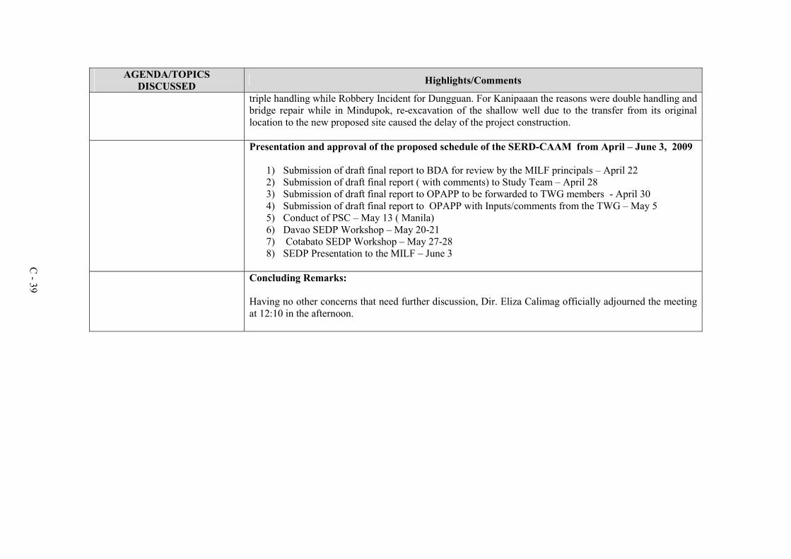
C - 39
AGENDA/TOPICS DISCUSSED Highlights/Comments
triple handling while Robbery Incident for Dungguan. For Kanipaaan the reasons were double handling and bridge repair while in Mindupok, re-excavation of the shallow well due to the transfer from its original location to the new proposed site caused the delay of the project construction.
Presentation and approval of the proposed schedule of the SERD-CAAM from April – June 3, 2009
1) Submission of draft final report to BDA for review by the MILF principals – April 22 2) Submission of draft final report ( with comments) to Study Team – April 28 3) Submission of draft final report to OPAPP to be forwarded to TWG members - April 30 4) Submission of draft final report to OPAPP with Inputs/comments from the TWG – May 5 5) Conduct of PSC – May 13 ( Manila) 6) Davao SEDP Workshop – May 20-21 7) Cotabato SEDP Workshop – May 27-28 8) SEDP Presentation to the MILF – June 3
Concluding Remarks:
Having no other concerns that need further discussion, Dir. Eliza Calimag officially adjourned the meeting at 12:10 in the afternoon.

APPENDICES
APPENDIX D
LIST OF PROVINCES, MUNICIPALITIES, BARANGAYS

APPENDIX D-1 : LIST OF PROVINCES, MUNICIPALITIES, BARANGAYS
1. CAAM COVERAGE Not all municipalities in the 13 provinces are part of CAAM. For example, only one municipality within both Compostela Valley and Davao Oriental are parts of CAAM. In general, CAAM consists of 148 municipalities and three (3) cities, and in terms of barangay, the count is 3847 barangays.
1.1 CAAM PROVINCES, MUNICIPALITIES AND BARANGAYS The list of baranagays per municipality is indicated in Table H1.1-1.
Table H1.1-1. List of CAAM Municipalities and Barangays MUNICIPALITY BARANGAY
ISABELA CITY (Capital)
Aguada, Balatanay, Baluno, Begang, Binuangan, Busay, Cabunbata, Calvario, Carbon, Diki, Dona Ramona T. Alano, Isabela Eastside (Pob.), Isabela Proper (Pob.), Kapatagan Grande, Kapayawan, Kaumpurnah Zone I, Kaumpurnah Zone II, Kaumpurnah Zone III, Kumalarang, La Piedad (Pob.), Lampinigan, Lanote, Lukbuton, Lumbang, Makiri, Maligue (Lunot), Marang-marang, Marketsite (Pob.), Masula, Menzi, Panigayan, Panunsulan, Port Area (Pob.), Riverside, San Rafael, Santa Barbara, Santa Cruz (Pob.), Seaside (Pob.), Small Kapatagan, Sumagdang, Sunrise Village (Pob.), Tabiawan, Tabuk (Pob.),Tampalan, Timpul
BALIGUIAN Alegria, Diangas, Diculom, Guimotan, Kauswagan, Kilalaban, Linay, Lumay, Malinao, Mamad, Mamawan, Milidan, Nonoyan, Poblacion,San Jose, Tamao, Tan-awan
KALAWIT Batayan, Botong, Concepcion, Daniel Maing (Dominolog), Fatima (Lacsutan), Gatas, Kalawit (Pob.), Marcelo, New Calamba, Palalian, Paraiso, Pianon, San Jose, Tugop*
LABASON Antonino (Pob.),Balas, Bobongan, Dansalan, Gabu, Gil Sanchez, Imelda, Immaculada, Kipit, La Union, Lapatan, Lawagan, Lawigan, Lopoc (Pob.), Malintuboan, New Salvacion, Osukan, Patawag, San Isidro, Ubay
SALUG
Bacong, Balakan, Binoni, Calucap, Canawan, Caracol, Danao, Dinoan, Dipolod, Fatima (Pogan) Ipilan, Lanawan, Ligua, Lipakan, Mucas, Pacuhan, Poblacion (Salug), Poblacion East, Pukay Ramon Magsaysay, Santo Niño, Tambalang, Tapalan
SIBUCO
Anongan, Basak, Bongalao, Cabbunan, Cawit-cawit, Culaguan, Cusipan, Dinulan, Jatian Kamarangan, Lakiki, Lambagoan, Limpapa, Lingayon, Lintangan, Litawan, Lunday, Malayal, Mantivo, Nala (Pob.), Panganuran, Pangian, Paniran, Pasilnahut, Poblacion, Puliran, Santo Niño (Culabog), Tangarak
SIOCON
Andres Micubo Jr. (Balili), Balagunan, Bucana, Bulacan, Candiz, Datu Sailila, Dionisio Riconalla, Jose P. Brillantes Sr. (Old Lituban), Latabon, Makiang, Malambuhangin, Malipot, Manaol, Mateo Francisco, Matiag, New Lituban, Pangian, Pisawak, Poblacion (Siocon), S. Cabral, Santa Maria, Siay, Suhaile Arabi, Tabayo, Tagaytay, Tibangao
SIRAWAI
Balatakan, Balonkan, Balubuan, Bitugan, Bongon, Catuyan, Culasian, Danganon, Doña Cecilia, Guban, Lagundi, Libucon, Lubok, Macuyon, Minanga, Motong, Napulan, Panabutan, Piacan, Piña, Pisa Itom, Pisa Puti, Pugos, Pula Bato, Pulang Lupa, Saint Mary (Pob.), San Nicolas (Pob.), San Roque (Pob.), San Vicente (Pob.), Sipakit, Sipawa, Sirawai Proper (Pob.), Talabiga, Tapanayan
ZAMBOANGA SIBUGAY
ALICIA
Alegria, Bagong Buhay, Bella, Calades, Concepcion, Dawa-dawa, Gulayon, Ilisan, Kapatagan, Kauswagan, Kawayan, La Paz, Lambuyogan, Lapirawan Litayon, Lutiman, Milagrosa (Baluno), Naga-naga, Pandan-pandan, Payongan, Poblacion, Santa Maria, Santo Niño, Talaptap, Tampalan, Tandiong Muslim, Timbang-timbang
BUUG
Agutayan, Bagong Borbon, Basalem, Bawang, Bliss, Bulaan, Compostela, Danlugan, Datu Panas, Del Monte, Guintuloan, Guitom, Guminta, Labrador, Lantawan, Mabuhay, Maganay, Manlin, Muyo, Pamintayan, Pling, Poblacion, Pulog, San Jose, Talairan, Talamimi, Villacastor (Galit)
D - 1

MUNICIPALITY BARANGAY
DIPLAHAN Balangao, Butong, Ditay, Gaulan, Goling, Guinoman, Kauswagan, Lindang, Lobing, Luop, Manangon, Mejo, Natan, Paradis, Pilar, Poblacion (Diplahan), Sampoli A, Sampoli B, Santa Cruz, Songcuya, Tinongtongan, Tuno
IMELDA Lower Baluran, Baluyan, Cana-an, Dumpoc, Gandiangan, Israel (Balian Israel), La Victoria, Lumpanac, Little Baguio, Lumbog, Mali Little Baguio, Poblacion (Santa Fe), San Jose, Santa Barbara, Balugo Balungisan, Pulawan (Mt. View), Upper Baluran
KABASALAN
Banker, Bolo Batallion, Buayan, Cainglet, Calapan, Calubihan, Concepcion (Balungis), Diampak, Dipala Gacbusan, Goodyear, Lacnapan, Little Baguio, Lumbayao, Nazareth, Palinta, Peñaranda, Poblacion, Riverside, Sanghanan, Santa Cruz, Sayao, Shiolan, Simbol, Sininan, Tamin, Tampilisan, Tigbangagan, Timuay Danda (Mangahas)
MALANGAS
Bacao, Basak-bawang, Bontong, Camanga, Candiis,Catituan, Dansulao, Del Pilar, Kigay, La Dicha, Lipacan, Logpond, Mabini, Malungon, Mulom, Overland, Palalian, Payag, Poblacion, Rebocon, San Vicente, Sinusayan, Tackling, Tigabon
NAGA Aguinaldo, Baga, Baluno, Bangkaw-bangkaw, Cabong, Crossing Sta. Clara, Gubawang, Guintoloan, Kaliantana, La Paz, Lower Sulitan, Mamagon, Marsolo, Poblacion, San Isidro, Sandayong, Santa Clara, Sulo, Tambanan, Taytay Manubo, Tilubog, Tipan, Upper Sulitan
OLUTANGA Bateria, Calais (Kalines), Esperanza, Fama, Galas, Gandaan, Kahayagan, Looc Sapi, Matim, Noque, Pulo Laum, Pulo Mabao, San Isidro, San Jose, Santa Maria, Solar (Pob.),Tambanan, Villacorte, Villagonzalo
PAYAO
Balian, Balogo, Balungisan, Binangonan, Bulacan, Bulawan, Calape, Dalama, Fatima (Silal), Guintolan, Guiwan, Katipunan, Kima, Kulasian, Kulisap, La Fortuna, Labatan, Mayabo (Santa Maria), Minundas (Santo. Niño), Mountain View (Puluan), Nanan,Poblacion (Payao), San Isidro, San Roque, San Vicente (Binangonan), Silal, Sumilong, Talaptap, Upper Sumilong
ROSELLER T. LIM
Ali Alsree, Balansag, Calula, Casacon, Don Perfecto, Gango, Katipunan, Kulambugan, Mabini, Magsaysay, Malubal, New Antique, New Sagay, Palmera, Pres. Roxas, Remedios, San Antonio, San Fernandino, San Jose, Santo Rosario, Siawang, Silingan, Surabay, Taruc, Tilasan, Tupilac
SIAY
Bagong Silang, Balagon, Balingasan, Balucanan, Bataan, Batu, Buyogan, Camanga, Coloran, Kimos (Kima), Labasan, Lagting, Laih, Logpond, Magsaysay, Mahayahay, Maligaya, Maniha, Minsulao, Mirangan, Monching, Paruk, Poblacion, Princesa Sumama, Salinding, San Isidro Sibuguey, Siloh, Villagracia
TALUSAN Aurora, Baganipay, Bolingan, Bualan, Cawilan, Florida, Kasigpitan, Laparay, Mahayahay,Moalboal, Sagay, Samonte, Poblacion (Talusan), Tuburan
TITAY
Achasol , Azusano, Bangco, Camanga, Culasian, Dalangin, Dalangin Muslim, Dalisay, Gomotoc, Imelda (Upper Camanga), Kipit, Kitabog, La Libertad, Longilog, Mabini, Malagandis, Mate, Moalboal, Namnama, New Canaan, Palomoc, Poblacion (Titay), Poblacion Muslim, Pulidan, San Antonio, Santa Fe, Supit, Tugop, Tugop Muslim
TUNGAWAN
Baluran, Batungan, Cayamcam, Datu Tumanggong, Gaycon, Langon, Libertad (Pob.), Linguisan Little Margos, Loboc, Looc-labuan, Lower Tungawan, Malungon, Masao, San Isidro, San Pedro San Vicente, Santo Niño, Sisay,Taglibas, Tigbanuang, Tigbucay, Tigpalay, Timbabauan, Upper Tungawan
ZAMBOANGA DEL SUR
AURORA
Acad,Alang-alang, Alegria, Anonang, Bagong Mandaue, Bagong Maslog, Bagong Oslob, Bagong Pitogo, Baki, Balas, Balide, Balintawak, Bayabas, Bemposa, Cabilinan, Campo Uno, Ceboneg, Commonwealth, Gubaan, Inasagan,Inroad, Kahayagan East (Katipunan), Kahayagan West, Kauswagan, La Paz (Tinibtiban), La Victoria, Lantungan, Libertad, Lintugop, Lubid, Maguikay, Mahayahay, Monte Alegre, Montela, Napo, Panaghiusa, Poblacion, Resthouse, Romarate, San Jose, San Juan, Sapa Loboc, Tagulalo, Waterfall
DIMATALING
Bacayawan, Baha, Balanagan, Baluno, Binuay, Buburay, Grap, Josefina, Kagawasan, Lalab, Libertad, Magahis, Mahayag, Mercedes, Poblacion, Saloagan, San Roque, Sugbay Uno, Sumbato, Sumpot, Tinggabulong, Tiniguangan, Tipangi, Upper Ludiong
DINAS
Bacawan, Benuatan, Beray, Don Jos, Dongos, East Migpulao, Guinicolalay, Ignacio Garrata (New Mirapao), Kinacap, Legarda 1, Legarda 2, Legarda 3, Lower Dimaya, Lucoban, Ludiong, Nangka, Nian, Old Mirapao, Pisa-an, Poblacion, Proper Dimaya, Sagacad, Sambulawan, San Isidro, Songayan, Sumpotan, Tarakan, Upper Dimaya, Upper Sibul, West Migpulao
KUMALARANG Bogayo, Bolisong, Boyugan East, Boyugan West, Bualan, Diplo, Gawil, Gusom, Kitaan Dagat, Lantawan, Limamawan, Mahayahay, Pangi, Picanan, Poblacion, Salagmanok, Secade, Suminalum
D - 2

MUNICIPALITY BARANGAY
LABANGAN
Bagalupa, Balimbingan (West Luya), Binayan, Bokong, Bulanit, Cogonan, Combo, Dalapang, Dimasangca, Dipaya, Langapod, Lantian, Lower Campo Islam (Pob.), Lower Pulacan, Lower Sang-an, New Labangan, Noboran, Old Labangan, San Isidro, Santa Cruz, Tapodoc, Tawagan Norte, Upper Campo Islam (Pob.), Upper Pulacan, Upper Sang-an
LAPUYAN
Bulawan, Carpoc, Danganan, Dansal, Dumara, Linokmadalum, Luanan, Lubusan, Mahalingeb, Mandeg, Maralag, Maruing, Molum, Pampang, Pantad, Pingalay, Poblacion, Salambuyan, San Jose, Sayog, Tabon, Talabab, Tiguha, Tininghalang, Tipasan, Tugaya
MARGOSA-TUBIG
Balintawak, Bularong, Digon, Guinimanan, Igat Island, Josefina, Kalian, Kolot, Limabatong, Limamawan, Lumbog, Magahis, Poblacion, Sagua, Talanusa, Tiguian, Tulapoc
PAGADIAN CITY (Capital)
Alegria, Balangasan (Pob.), Balintawak, Baloyboan, Banale, Bogo, Bomba, Buenavista, Bulatok, Bulawan, Dampalan, Danlugan, Dao, Datagan, Deborok, Ditoray, Dumagoc, Gatas (Pob.), Gubac, Gubang, Kagawasan, Kahayagan, Kalasan, Kawit, La Suerte, Lala, Lapidian, Lenienza, Lizon Valley, Lourdes, Lower Sibatang, Lumad, Lumbia, Macasing, Manga, Muricay, ,Napolan, Palpalan, Pedulonan, Poloyagan, San Francisco (Pob.), San Jose (Pob.), San Pedro (Pob.), Santa Lucia (Pob.), Santa Maria, Santiago (Pob.), Santo Niño,Tawagan Sur, Tiguma, Tuburan (Pob.), Tulangan, Tulawas, Upper Sibatang,White Beach
TABINA Abong-abong, Baganian, Baya-baya, Capisan, Concepcion, Culabay, Doña Josefina, Lumbia, Mabuhay, Malim, Manikaan, New Oroquieta, Poblacion, San Francisco, Tultolan
TUKURAN
Alindahaw, Baclay, Balimbingan, Buenasuerte, Camanga, Curvada, Laperian, Libertad, Lower Bayao, Luy-a, Manilan, Manlayag, Militar, Navalan, Panduma Senior, Sambulawan, San Antonio, San Carlos (Pob.), Santo Niño (Pob.), Santo Rosario, Sugod, Tabuan, Tagulo, Tinotungan, Upper Bayao
BACOLOD Alegria, Babalaya, Babalayan Townsite, Binuni, Demologan, Dimarao, Esperanza, Kahayag, Liangan East, Mati, Minaulon, Pagayawan, Poblacion Bacolod, Punod (Maliwanag), Rupagan
BALOI
Abaga, Adapun-Ali (Dariat), Angandog (Bulao), Angayen (Balut), Bangko, Batolacongan (Basagad), Buenavista, Cadayonan, Landa (Gadongan), Lumbac, Mamaanun, Maria-Cristina, Matampay, Nangka, Pacalu, Poblacion East, Poblacion West, Sandor (Daduan), Sangcad (Cormatan ), Sarip-Alawi (Payawan), Sigayan
KAUSWAGAN Bagumbayan (Pob.), Bara-ason, Kawit Occidental, Kawit Oriental, Libertad, Poblacion, Tacub, Tingintingin, Tugar
LINAMON Busque, Larapan, Magoong, Napo, Poblacion, Purakan, Robocon, Sambur
MAGSAYSAY
Babasalon, Baguiguicon, Daan Campo, Durianon, Ilihan, Lamigadato, Lemoncret, Lower Caningag (Perimbangan), Lubo, Lumbac, Malabaogan, Mapantao, Olango, Pangao, Pelingkingan, Poblacion (Bago-A-Ingud), Rarab, Somiorang, Talambo, Tambacon, Tawinian, Tipaan, Tombador, Upper Caningag (Taguitingan)
MATUNGAO Bangco, Batal, Batangan, Bubong Radapan, Cadayonan, Matampay, Pangi, Pasayanon, Poblacion (Matungao), Puntod, Santa Cruz, Somiorang
MUNAI
Bacayawan, Balabacun, Balintad, Dalama, Kadayonan, Lindongan, Lingco-an, Taporog, Tamparan (Mandaya), Tambo, Tagoranao, Sandigamunai, Ramain, Punong, Pindolonan, Pantaon, Pantao-A-Munai, Pantao, Panggao, Old Poblacion, North Cadulawan, Matampay, Maganding, Madaya, Lumba-Bayabao, Lininding
NUNUNGAN
Abaga, Bangco, Cabasaran (Laya), Canibongan, Dimayon, Inayawan, Kaludan, Karcum, Katubuan, Lianga, Lupitan, Malaig, Mangan, Masibay, Notongan, Panganapan, Pantar, Paridi, Petadun Poblacion (Nunungan Proper), Rarab , Raraban, Rebucon, Songgod, Taraka
PANTAO RAGAT Aloon, Banday, Bobonga Pantao Ragat, Bobonga Radapan, Cabasagan, Calawe, Culubun, Dilimbayan, Dimayon, Lomidong, Madaya, Maliwanag, Matampay, Natangcopan, Pansor, Pantao Marug, Poblacion East, Poblacion West, Tangcal, Tongcopan
PANTAR
Bangcal, Bowi, Bubong Madaya, Cabasaran, Cadayonan, Campong, Dibarosan, Kalanganan East Kalanganan Lower, Kalilangan, Lumba-Punod, Pantao-Marug, Pantao-Ranao, Pantar East, Pitubo, Poblacion, Poona-Punod, Punod, Sundiga-Punod, Tawanan, West Pantar
POONA PIAGAPO
Alowin, Bubong-Dinaig, Cabasaran, Cadayonan, Caromatan, Daramba, Dinaig, Kablangan, Linindingan, Lumbatan, Lupitan, Madamba, Madaya, Maliwanag, Nunang, Nunungan, Pantao Raya, Pantaon, Pendolonan, Pened, Piangamangaan, Poblacion (Lumbacaingud), Sulo, Tagoranao, Tangclao, Timbangalan
SALVADOR
Barandia, Bulacon, Buntong, Calimodan, Camp III, Curva-Miagao, Daligdigan, Inasagan, Kilala Mabatao,Madaya, Mamaanon, Mapantao, Mindalano, Padianan, Pagalongan, Pagayawan, Panaliwad-on, Pangantapan, Pansor, Patidon, Pawak, Poblacion, Saumay, Sudlon
D - 3

MUNICIPALITY BARANGAY
SAPAD Baning, Buriasan (Pob.), Dansalan, Gamal, Inudaran I, Inudaran II, Karkum, Katipunan, Mabugnao, Maito Salug, Mala Salug, Mama-anon, Mapurog, Pancilan, Panoloon, Pili, Sapad
SULTAN NAGA DIMAPORO
Bangaan, Bangco, Bansarvil, Bauyan, Cabongbongan, Calibao, Calipapa, Calube, Campo Islam, Capocao, Dabliston, Dalama, Dangulaan, Ditago, Ilian, Kauswagan, Kirapan, Koreo, Lantawan, Mabuhay, Maguindanao, Mahayahay, Mamagum, Mina, Pandanan, Payong, Pikalawag, Pikinit, Piraka, Poblacion, Ramain, Rebucon, Sigayan, Sugod, Tagulo, Tantaon, Topocon (Capocgo)
TAGOLOAN Dalamas, Darimbang, Dimayon, Inagongan, Kiazar (Pob.), Malimbato, Panalawan TANGCAL
Bayabao, Berwar, Big Banisilon, Big Meladoc, Bubong, Lamaosa, Linao, Lindongan, Lingco-an, Papan, Pelingkingan, Poblacion, Poona Kapatagan, Punod, Small Banisilon, Small Meladoc, Somiorang, Tangcal Proper
COMPOSTELA VALLEY
PANTUKAN Araibo, Bongabong, Bongbong, Kingking (Pob.), Las Arenas, Magnaga, Matiao, Napnapan, P. Fuentes,Tagdangua, Tag-Ugpo, Tambongon, Tibagon
DAVAO ORIENTAL
TARRAGONA Cabagayan, Central (Pob.), Dadong, Jovellar, Limot, Lucatan, Maganda, Ompao, Tomoaong, Tubaon
COTABATO (NORTH COTABATO)
ALEOSAN Bagolibas, Cawilihan, Dualing, Dunguan, Katalicanan, Lawili, Lower Mingading, Luanan, Malapang, New Leon, New Panay, Pagangan, Palacat, Pentil, San Mateo, Santa Cruz, Tapodoc, Tomado, Upper Mingading
ARAKAN
Allab, Anapolon , Badiangon, Binoongan, Dallag, Datu Ladayon, Datu Matangkil, Doroluman, Gambodes, Ganatan, Kabalantian, Katipunan, Kinawayan, Kulaman Valley, Lanao Kuran, Libertad, Makalangot, Malibatuan, Maria Caridad, Meocan, Naje, Napalico, Poblacion (Greenfield), Salasang, San Miguel, Santo Niño, Sumalili, Tumanding
BANISILAN
Banisilan Poblacion, Busaon, Capayangan, Carugmanan, Gastay, Kalawaig, Kiar, Malagap, Malinao, Miguel Macasarte, Pantar, Paradise, Pinamulaan, Poblacion II, Puting-bato, Solama Thailand, Tinimbacan, Tumbao-Camalig, Wadya
CARMEN
Aroman, Bentangan, Cadiis, General Luna, Katanayanan, Kib-Ayao, Kibenes, Kibugtongan Kilala, Kimadzil, Kitulaan, Langogan, Lanoon, Liliongan, Lumayong, Macabenban, Malapag, Manarapan, Manili, Nasapian, Palanggalan, Pebpoloan, Poblacion, Ranzo, Tacupan, Tambad,Tonganon, Tupig
KABACAN Aringay, Bangilan, Bannawag, Buluan, Cuyapon, Dagupan, Katidtuan, Kayaga, Kilagasan, Magatos, Malamote, Malanduague, Nanga-an, Osias, Paatan Lower, Paatan Upper, Pedtad, Pisan, Poblacion, Salapungan, Sanggadong, Simbuhay, Simone, Tamped
LIBUNGAN Abaga, Baguer, Barongis, Batiocan, Cabaruyan, Cabpangi, Demapaco, Grebona, Gumaga, Kapayawi, Kiloyao, Kitubod, Malengen, Montay, Nica-an, Palao, Poblacion, Sinapangan, Sinawingan, Ulamian
M'LANG
Bagontapay, Bialong, Buayan, Calunasan, Dagong, Dalipe, Dungo-an, Gaunan, Inas, Katipunan, La Fortuna, La Suerte, Langkong, Lepaga, Liboo, Lika, Luz Village, Magallon, Malayan, New Antique, New Barbaza, New Consolacion, New Esperanza, New Janiuay, New Kalibo, New Lawa-an, New Rizal, Nueva Vida, Pag-asa, Palma-Perez, Poblacion, Poblacion B, Pulang-lupa, Sangat, Tawantawan, Tibao, Ugpay
MAKILALA
Batasan, Bato, Biangan, Buena Vida, Buhay, Bulakanon, Cabilao, Concepcion, Dagupan, Garsika, Guangan, Indangan, Jose Rizal, Katipunan II, Kawayanon, Kisante, Leboce, Libertad, Luayon,Luna Norte, Luna Sur, Malabuan, Malasila, Malungon, New Baguio, New Bulatukan, New Cebu, New Israel, Old Bulatukan, Poblacion, Rodero, Saguing, San Vicente, Santa Felomina, Santo Niño, Sinkatulan, Taluntalunan, Villaflores
MATALAM
Arakan, Bangbang, Bato, Central Malamote, Dalapitan, Estado, Ilian, Kabulacan, Kibia, Kibudoc, Kidama, Kilada, Lampayan, Latagan, Linao, Lower Malamote, Manubuan, Manupal, Marbel, Minamaing, Natutungan, New Abra, New Alimodian, New Bugasong, New Pandan, Patadon West, Pinamaton, Poblacion, Salvacion, Santa Maria, Sarayan, Taculen, Taguranao, Tamped (Tampad)
D - 4

MUNICIPALITY BARANGAY
MIDSAYAP
Agriculture, Anonang, Arizona, Bagumba, Baliki, Barangay Poblacion 1, Barangay Poblacion 2, Barangay Poblacion 3, Barangay Poblacion 4, Barangay Poblacion 5, Barangay Poblacion 6 Barangay Poblacion 7, Barangay Poblacion 8, Bitoka, Bual Norte, Bual Sur, Bulanan Upper, Central Bulanan, Central Glad, Central Katingawan, Central Labas, Damatulan, Ilbocean, Kadigasan, Kadingilan, Kapinpilan, Kimagango, Kiwanan, Kudarangan, Lagumbingan, Lomopog, Lower Glad, Lower Katingawan, Macasendeg, Malamote, Malingao, Milaya, Mudseng, Nabalawag, Nalin, Nes, Olandang, Palongoguen, Patindeguen, Rangaban, Sadaan, Salunayan, Sambulawan, San Isidro, San Pedro, Santa Cruz, Tugal, Tumbras, Upper Glad I, Upper Glad II, Upper Labas, Villarica
PIGKAWAYAN
Anick (Upper Balogo), Balacayon, Balogo, Banucagon,Bulua, Bulucaon, Buricain,Cabpangi, Capayuran, Central Panatan, Datu Binasing, Datu Mantil, Kadingilan, Kimarayang, Libungan Torreta, Lower Baguer, Lower Pangangkalan, Malagakit, Maluao, Matilac, Midpapan I, Midpapan II, Mulok, New Culasi, New Igbaras, New Panay, North Manuangan, Patot, Payong-payong, Poblacion I, Poblacion II, Poblacion III, Presbitero, Renibon, Simsiman, South Manuangan, Tigbawan, Tubon, Upper Baguer (Baguer), Upper Pangangkalan
PIKIT
Bagoaingud (Bagoinged), Balabak, Balatican, Balong, Balungis, Barungis, Batulawan, Bualan, Buliok, Bulod, Bulol, Calawag, Dalingaoen (Lalingaon), Damalasak, Fort Pikit, Ginatilan, Gligli, Gokoton (Gokotan), Inug-ug, Kabasalan, Kalacacan, Katilacan, Kolambog, Ladtingan, Lagunde, Langayen, Macabual, Macasendeg, Manaulanan, Nabundas, Nalapaan, Nunguan, Paidu Pulangi, Pamalian, Panicupan, Poblacion, Punol, Rajah Muda, Silik, Takipan, Talitay, Tinutulan
SARANGANI
GLAN
Baliton, Batotuling, Batulaki, Big Margus, Burias, Cablalan, Calabanit, Calpidong, Congan, Cross, Datalbukay, E. Alegado, Glan Padidu, Gumasa, Ilaya, Kaltuad, Kapatan, Lago, Laguimit,Mudan, New Aklan, Pangyan, Poblacion, Rio Del Pilar, San Jose, San Vicente, Small Margus, Sufatubo, Taluya, Tango, Tapon
KIAMBA Badtasan, Datu Dani, Gasi, Kapate, Katubao, Kayupo, Kling (Lumit), Lagundi, Lebe, Lomuyon, Luma, Maligang, Nalus, Poblacion, Salakit, Suli, Tablao, Tamadang, Tambilil
MAASIM Amsipit, Bales, Colon, Daliao, Kabatiol, Kablacan,Kamang, Kanalo, Lumasal, Lumatil, Malbang, Nomoh, Pananag, Poblacion (Maasim), Seven Hills, Tinoto
MALAPATAN Daan Suyan, Kihan, Kinam, Libi, Lun Masla, Lun Padidu, Patag, Poblacion (Malapatan), Sapu Masla, Sapu Padidu, Tuyan, Upper Suyan
SOUTH COTABATO POLOMOLOK
Bentung, Cannery Site, Crossing Palkan, Glamang, Kinilis, Klinan 6, Koronadal Proper, Lam-Caliaf, Landan, Lapu, Lumakil, Magsaysay, Maligo, Pagalungan, Palkan, Poblacion, Polo, Rubber, Silway 7, Silway 8, Sulit, Sumbakil, Upper Klinan
TUPI Acmonan, Bololmala, Bunao, Cebuano, Crossing Rubber, Kablon, Kalkam, Linan, Lunen, Miasong, Palian, Poblacion, Polonuling, Simbo, Tubeng
SULTAN KUDARAT
BAGUMBAYAN Bai Sarifinang, Biwang, Busok, Chua, Daguma, Daluga, Kabulanan, Kanulay, Kapaya, Kinayao, Masiag, Monteverde, Poblacion, Santo Niño, Sison, South Sepaka, Sumilil, Titulok, Tuka
COLUMBIO Bantangan (Lasak), Datablao, Eday, Elbebe, Lasak, Libertad, Lomoyon, Makat (Sumali Pas), Maligaya, Mayo, Nativida, Poblacion, Polomolok, Sinapulan, Sucob, Telafas
ESPERANZA Ala, Daladap, Dukay, Guiamalia, Ilian, Kangkong, Laguinding, Magsaysay, Margues, New Panay, Numo, Paitan, Pamantingan, Poblacion, Sagasa, Salabaca, Saliao, Salumping, Villamor
ISULAN (Capital) Bambad, Bual, Dansuli, D'Lotilla, Impao, Kalawag I (Pob.), Kalawag II (Pob.), Kalawag III (Pob.), Kenram, Kolambog, Kudanding, Lagandang, Laguilayan, Mapantig, New Pangasinan, Sampao, Tayugo
KALAMANSIG Bantogon (Santa Clara), Cadiz, Datu Ito Andong, Datu Wasay, Dumangas Nuevo, Hinalaan, Limulan, Nalilidan, Obial, Pag-asa, Paril, Poblacion, Sabanal, Sangay, Santa Maria
LAMBAYONG (MARIANO MARCOS)
Caridad (Cuyapon), Didtaras, Gansing (Bilumen), Kabulakan, Kapingkong, Katitisan, Lagao, Lilit, Madanding, Maligaya, Mamali, Matiompong, Midtapok, New Cebu, Palumbi, Pidtiguian, imbalayan,Pinguiaman,Poblacion (Lambayong), Sadsalan, Seneben, Sigayan, Tambak, Tinumigues, Tumiao (Tinaga), Udtong
LEBAK
Barurao, Barurao II, Basak, Bolebok, Bululawan, Capilan, Christiannuevo, Datu Karon, Kalamongog, Keytodac, Kinodalan, New Calinog, Nuling, Pansud, Pasandalan, Poblacion, Poblacion II, Poblacion III, Poloy-poloy, Purikay, Ragandang, Salaman, Salangsang, Taguisa, Tibpuan, Tran, Villamonte
D - 5

MUNICIPALITY BARANGAY
LUTAYAN Antong, Bayasong, Blingkong, Lutayan Proper, Maindang, Mamali, Manili, Palavilla, Sampao Sisiman, Tamnag (Pob.)
PALIMBANG
Akol, Badiangon, Baliango, Balwan (Bulan), Bambanen, Baranayan, Barongis, Batang-baglas, Butril, Colobe, Domolol, Kabuling, Kalibuhan, Kanipaan, Kidayan, Kiponget, Kisek, Kraan, Kulong-kulong, Langali, Libua, Ligao, Lopoken (Lepolon), Lumitan, Maganao, Maguid, Malatuneng (Malatunol), Malisbong, Medol, Milbuk, Mina, Molon, Namat Masla, Napnapon, Poblacion, San Roque, Tibuhol (East Badiangon), Wal, Wasag
PRESIDENT QUIRINO
Bagumbayan, Bannawag, Bayawa, C. Mangilala, Estrella, Kalanawe I, Kalanawe II, Katico,Malingon, Mangalen, Pedtubo, Poblacion, (Sambulawan), Romualdez, San Jose, San Pedro (Tuato), Sinakulay, Suben, Tinaungan, Tual (Liguasan)
SEN. NINOY AQUINO
Banali, Basag, Buenaflores, Bugso, Buklod, Gapok, Kadi, Kapatagan, Kiadsam, Kuden, Kulaman, Lagubang, Langgal, Limuhay, Malegdeg, Midtungok, Nati, Sewod, Tacupis, Tinalon
BASILAN
LAMITAN
Arco, Ba-as, Baimbing, Balagtasan, Balas, Balobo, Bato, Baungos, Bohebessey, Boheibu, Bohenange, Bohesapa, Boheyakan, Boheyawas, Buahan, Bulanting, Bulingan, Cabobo, Calugusan, Campo Uno, Colonia, Danit-Puntocan, Kulay Bato, Lebbuh, Limo-ok, Lo-ok, Luksumbang, Lumuton, Maganda, Malakas, Maligaya, Malinis (Pob.), Malo-ong Canal, Malo-ong San Jose, Matatag, Matibay, Parangbasak, Sabong, Santa Clara, Sengal, Simbangon, Tandong Ahas, Tumakid, Ubit, Ulame
LANTAWAN
Atong-atong, Bagbagon, Baluk-baluk, Baungis, Bulan-bulan, Bulanza, Calayan, Calugusan, Canibungan, Dasalan, Landugan, Lantawan Proper (Pob.), Lawila, Lawi-lawi, Lower Bañas, Lower Manggas, Lubukan, Luukbongsod, Luuk-Maluha, Mananggal, Matarling, Matikang, Palahangan, Pamucalin, Panducan, Paniongan, Parian-Baunoh, Sangbay Big, Sangbay Small, Suba-an (Pangasahan), Switch Yakal, Tairan, Tausan, Upper Bañas, Upper Manggas
MALUSO
Abong-Abong, Batungal, Calang Canas, Fuente Maluso, Guanan North (Zone I), Guanan South (Zone II), Limbubong, Mahayahay Lower (Zone I), Mahayahay Upper (Zone II), Muslim Area, Port Holland Zone I Pob. (Upper), Port Holland Zone II Pob. (Shipyard), Port Holland Zone III Pob. (Samal Vil), Port Holland Zone IV (Lower), Port Holland Zone V (Shipyard Tabuk), Taberlongan, Tamuk, Townsite (Pob.), Tubigan, Upper Garlayan
SUMISIP
Babag (Babuan Island), Bacung, Baiwas, Balanting, Basak, Benembengan Lower, Benembengan Upper, Bohe-languyan, Boloh-boloh, Bukut-Umus, Buli-buli, Cabcaban, Cabengbeng Lower, Cabengbeng Upper, Ettub-ettub, Guiong, Kaum-Air, Kaumpamatsakem, Kaumpurnah, Lanawan, Libug, Limbocandis, Lukketon, Luuk-Bait, Mahatalang, Manaul, Mangal (Pob.), Marang, Mebak Pisak-pisak, Sahaya Bohe Bato, Saluping, Sapah Bulak, Suligan (Babuan Island), Sulloh (Tapiantana), Sumisip Central, Tambulig Buton, Tikus, Tongsengal, Tong-Umus, Tumahubong
TUBURAN
Basakan, Bohetambis, Buton, Caddayan, Calut, Candiis, Duga-a, Katipunan, Lahi-lahi, Langil Langong, Languyan, Linongan, Lower Bato-bato, Lower Sinangkapan, Lower Tablas,Mahawid, Mangalut, Manguso, Paguengan, Pintasan, Semut, Seronggon, Sibago, Sinulatan, Sulutan Matangal, Tablas Usew, Tuburan Proper (Pob.), Upper Bato-bato, Upper Sinangkapan
MAGUINDANAO AMPATUAN
Banaba, Dicalongan (Pob.), Dimampao, Guinibon, Kakal, Kamasi, Kapinpilan, Kauran, Kaya-kaya Maganoy, Malatimon, Mao, Maranding, Matagabong, Salman, Saniag, Sugadol, Talisawa, Tomicor, Tubak, Tukanolocong (Tukanologong)
BULUAN
Daladagan, Digal, Kabuling, Kalian, Kayaga, Kayupo (Cuyapo), Lepak, Lower Dlag, Lower Siling, Luayan, Malangit, Maslabeng, Paitan, Panapan, Pandag, Poblacion, Popol, Talitay, Tenok, Tinambulan, Tumbao, Upper Dlag, Upper Siling
DATU PAGLAS
Alip (Pob.), Bonawan, Bulod, Damalusay, Damawato, Datang, Elbebe, Kalumenga (Kalumanga) Katil, Lipao, Lomoyon, Madidis, Makat, Malala, Mangadeg, Manindolo, Mao, Napok, Palao sa Buto, Poblacion, Puya, Salendab, Sepaka
DATU PIANG
Alonganan, Ambadao, Andavit, Bakat, Balanakan, Balong, Buayan, Butilen, Dado, Damabalas, Dapiawan, Dasawao, Duaminanga, Elian, Ganta, Gawang, Inaladan, Kabengi, Kalipapa, Kitango, Kitapok, Liong, Madia, Magaslong, Masigay, Montay, Pagatin, Pandi, Penditen, Poblacion (Dulawan), Reina Regente, Salbu, Sambulawan, Tee
MAMASAPANO Bagumbong, Dabenayan, Daladap, Dasikil, Duguengen, Liab, Libutan, Linantangan, Lusay, Mamasapano, Manongkaling, Pagatin, Pidsandawan, Pimbalakan, Pusao, Sapakan, Tuka, Tukanalipao
D - 6

MUNICIPALITY BARANGAY
PAGAGAWAN Balatungkayo (Batungkayo), Bulit, Bulod, Dungguan, Limbalud, Maridagao, Nabundas, Pagagawan, Talapas, Talitay, Tunggol
PAGALUNGAN Bagoenged, Buliok, Dalgan, Damalasak, Galakit, Inug-ug, Kalbugan, Kilangan, Kudal, Layog Linandangan, Poblacion
GEN. S. K. PENDATUN
Badak, Bulod, Damakling, Damalusay, Kaladturan, Kulasi, Lao-lao,Lasangan, Lower Idtig, Lumabao, Makainis, Midconding, Midpandacan, Paglat, Panosolen, Ramcor, Tonggol, Upper Idtig
SHARIFF AGUAK (MAGANOY)
Bagong, Bialong, Bulayan, Dale-Bong, Iganagampong, Kuloy, Labu-labu, Lapok (Lepok) Limpongo, Macalag, Maitumaig, Malangog, Malingao, Meta, Nabundas, Pamalian, Panangeti, Pikeg, Poblacion, Sata, Tapikan, Timbangan, Tina, Tuayan, Tuntungan
SOUTH UPI Biarong, Bongo, Itaw, Kigan, Kuya, Lamud, Looy, Pandan, Pilar, Romangaob (Pob.), San Jose
SULTAN SA BARONGIS (LAMBAYONG)
Angkayamat, Baital, Bakat, Barurao, Bulod, Dapantis, Darampua, Gadungan, Gaunan, Kulambog, Langgapanan, Malibpolok, Masulot, Mileb, Paldong, Panadtaban, Papakan, Pidsandawan, Sampao, Sapakan (Pob.), Tabungao, Tugal, Tukanakuden
TALAYAN
Ahan, Bagan, Binangga North, Binangga South, Boboguiron, Brar, Damablac, Datalpandan, Fugotan, Fukol, Kalumamis, Kateman, Katibpuan, Kedati, Lambayao, Lanting, Linamunan, Macasampen, Marader, Midtimbang (Pob.), Muslim, Muti, Sampao, Talayan, Tamar, Tambunan I, Tambunan II, Timbaluan, Tulunan
TALITAY Adaon, Bintan (Bentan), Gadungan, Kiladap, Kilalan, Kuden, Makadayon, Manggay, Mapayag, Nunangan (Nunangen), Pageda, Talitay, Tugal
SHARIFF KABUNSUAN
BARIRA Barira (Pob.), Bualan, Gadung, Liong, Lipa, Lipawan, Marang, Minabay, Nabalawag, Rominimbang, Togaig
BULDON Ampuan, Aratuc, Cabayuan, Calaan (Pob.), Dinganen, Edcor (Gallego Edcor), Karim, Kulimpang Mataya, Minabay, Nuyo, Oring, Pantawan, Piers, Rumidas
DATU ODIN SINSUAT (DINAIG)
Ambolodto, Awang, Badak, Bagoenged, Baka (Datu Pinguiaman), Benolen, Bitu, Bongued, Bugawas, Capiton, Dados, Dalican Poblacion, Dinaig Proper, Dulangan, Kakar, Kenebeka, Kurintem, Kusiong, Labungan, Linek, Makir, Margues, Mompong, Nekitan,Sapalan, Semba, Sibuto, Sifaren (Sifaran), Tambak, Tamontaka, Tanuel, Tapian, Taviran, Tenonggos
KABUNTALAN (TUMBAO)
Bagumbayan, Balong, Buterin, Dadtumog (Dadtumeg), Damatog, Gambar, Ganta, Gayonga, Guiawa, Indatuan, Kapimpilan, Katidtuan, Langeban, Libungan, Liong, Lower Taviran, Maitong Matilak, Montay, Pagalungan, Paulino Labio, Payan, Pedtad, Pened, Poblacion, Sabaken, Tumaguinting, Upper Tavir
MATANOG Bayanga Norte, Bayanga Sur, Bugasan Norte, Bugasan Sur (Pob.), Kidama, Langco, Langkong, Sapad
PARANG
Bongo Island (Litayen), Campo Islam, Cotongan, Gadungan, Guiday T. Biruar, Gumagadong Calawag, Kabuan, Landasan (Sarmiento), Limbayan, Macasandag, Magsaysay, Making, Manion, Nituan, Orandang, Pinantao, Poblacion, Poblacion II, Polloc, Samberen, Tagudtongan, Tuca-Maror
SULTAN KUDARAT (NULING)
Alamada, Balut, Banatin, Banubo, Boliok, Bulalo, Bulibod, Bungabong, Calsada, Crossing Simuay, Dagurongan, Dalumangcob (Pob.), Damaniog, Darapanan, Gang, Inawan, Kabuntalan Kakar, Kapimpilan, Katamlangan (Matampay), Katidtuan, Katuli, Kirkir, Ladia, Limbo, Macabico (Macabiso), Maidapa, Makaguiling, Matengen, Mulaug, Nalinan, Namuken, Nara, Nekitan, Olas, Panatan, Pigcalagan, Pigkelegan (Ibotegen), Pinaring, Pingping, Raguisi, Rebuken, Salimbao, Sambolawan, Senditan, Simuay/Seashore, Solon, Tambo, Tapayan, Tariken, Tuka, Ungap
LANAO DEL SUR
BACOLOD Alegria, Babalaya, Babalayan Townsite, Binuni, Demologan, Dimarao, Esperanza, Kahayag, Liangan East, Mati, Minaulon, Pagayawan, Poblacion Bacolod, Punod (Maliwanag), Rupagan
BACOLOD-KALAWI (BACOLOD GRANDE)
Ampao, Bagoaingud, Balut, Barua, Buadiawani, Bubong, Daramoyod, Dilabayan, Dipatuan Gandamato, Gurain, Ilian, Lama, Liawao, Lumbaca-Ingud, Madanding, Orong, Pindolonan Poblacion I, Poblacion II, Raya, Rorowan, Sugod, Tambo, Tuka I, Tuka II
BALABAGAN
Bagoaingud, Banago, Barorao, Batuan, Budas, Buenavista, Buisan, (Bengabeng), Calilangan, Igabay, Ilian, Lalabuan, Lorenzo, Lower Itil, Lumbac, Macao, Magulalung Occidental, Magulalung Oriental, Matampay, Matanog, Molimoc, Narra, Pindolonan, Plasan, Poblacion (Balabagan), Purakan, Tataya, Upper Itil
D - 7

MUNICIPALITY BARANGAY
BALINDONG (WATU)
Abaga, Bantoga Wato, Barit, Bolinsong, Borakis, Bualan, Bubong, Bubong Cadapaan, Cadapaan, Cadayonan, Dadayag, Dado, Dibarusan, Dilausan, Dimarao, Ingud, Kaluntay, Lalabuan, Lati, Lilod, Limbo, Lumbac Lalan, Lumbac Wato, Lumbayao, Magarang, Malaig, Nusa Lumba Ranao, Padila, Pagayawan, Paigoay, Pantaragoo, Poblacion (Balindong), Raya, Salipongan, Talub, Tantua Raya, Tomarompong, Tuka Bubong
BAYANG
Bagoaingud, Bairan (Pob.), Bandingun, Biabi, Bialaan, Bubong Lilod, Bubong Raya, Cadayonan, Cadingilan Occidental, Cadingilan Oriental, Condaraan Pob. (Condaraan Dimadap), Cormatan, Gandamato, Ilian, Lalapung Central, Lalapung Proper (Pob.), Lalapung Upper, Linao,Linuk (Pob.), Liong, Lumbac, Lumbac Cadayonan, Maliwanag, Mapantao, Mimbalawag, Palao, Pama-an Pamacotan, Pantar, Parao, Patong, Poblacion (Bayang), Porotan, Rantian, Raya Cadayonan, Rinabor (Pob.), Samporna (Pob.), Sapa, Silid, Sugod, Sultan Pandapatan, Sumbag (Pob.) Tagoranao, Tangcal, Tangcal Proper (Pob.), Tomarompong, Tomongcal Ligi, Torogan,Tuca (Pob.)
BINIDAYAN
Badak, Baguiangun, Balut Maito, Basak, Bubong, Bubonga-Ranao, Dansalan Dacsula, Ingud, Kialilidan, Lumbac, Macaguiling, Madaya, Magonaya, Maindig, Masolun, Olama, Pagalamatan (Pob.), Pantar, Picalilangan, Picotaan, Pindolonan, Poblacion, Soldaroro, Tambac, Timbangan, Tuca
BUADIPOSO-BUNTONG
Bacolod, Bangon, Bangon Proper, Boto Ragondingan, Buadiposo Lilod, Buadiposo Proper, Buadiposo Raya, Bubong, Buntong Proper, Cadayonan, Dansalan, Datu Tambara, Dirisan, Gata, Kalakala, Katogonan, Lumbac, Lumbatan Manacab, Lumbatan Pataingud, Lunduban (Ragondingan), Manacab (Pob.), Minanga (Buntong), Paling, Pindolonan, Pualas, Ragondingan East, Ragondingan Proper, Ragondingan West, Raya Buntong (Buntong East), Sapot, Tangcal, Tarik, Tuka
BUBONG
Bacolod, Bagoaingud, Bansayan, Basingan, Batangan, Bualan, Bubonga Didagun, Carigongan, Dalaon, Dibarosan, Dilabayan, Dimapatoy, Dimayon, Dimayon Proper, Diolangan, Guiguikun, Madanding, Malungun, Masorot, Matampay Dimarao, Miabalawag, Montiaan, Pagayawan, Palao, Panalawan, Pantar, Pendogoan, Pindolonan, Poblacion (Bubong), Polayagan, Punud, Ramain Bubong, Rogero, Salipongan, Sunggod, Taboro
BUMBARAN Poblacion (Apartfort), Bagumbayan, Bandara-Ingud, Comara, Frankfort, Lambanogan, Lico, Mansilano, Natangcopan, Pagonayan, Pagalamatan, Piagma, Punud, Ranao-Baning, Salam, Sagua-an, Sumugot
BUTIG Bayabao Poblacion, Butig Proper, Cabasaran, Coloyan Tambo, Dilimbayan, Dolangan, Malungun Pindolonan, Poktan, Ragayan, Raya, Samer, Sandab Madaya, Sundig, Timbab, Tiowi
DITSAAN-RAMAIN
Baclayan Lilod, Baclayan Raya, Bagoaingud, Barimbingan, Bayabao, Buadi Alao, Buadi Babai, Buadi Oloc, Buayaan Lilod, Buayaan Madanding, Buayaan Raya, Bubong Dangiprampiai, Dado, Dangimprampiai, Darimbang, Dilausan, Ditsaan, Gadongan, Linamon, Lumbatan Ramain, Maindig Ditsaan, Mandara, Maranao Timber (Dalama), Pagalongan Buadiadingan, Pagalongan Ginaopan, Pagalongan Masioon, Pagalongan Proper, Polo, Ramain Poblacion, Ramain Proper, Rantian, Sultan Pangadapun, Sundiga Bayabao, Talub
GANASSI
Bagoaingud, Balintad, Balintad A, Barit, Barorao, Bato Batoray, Baya, Campong a Raya, Campong Sabela, Dapaan, Gadongan, Gui, Linuk, Lumbac, Lumbacaingud, Macabao, Macaguiling, Masolun, Pagalongan, Pamalian, Pangadapun, Panggawalupa, Pantaon, Pantaon A, Para-aba, Pindolonan, Poblacion, Sekun Matampay, Sogod Madaya, Tabuan, Taganonok, Taliogon
CALANOGAS (KALANOGAS)
Bubonga Ranao, Calalaoan (Pob.), GasInoma, Inudaran, Luguna, Mimbalawag, Ngingir Pagalongan, Panggawalupa, Pantaon, Piksan, Pindolonan, Punud, Tagoranao, Taliboboka, Tambac
KAPAI
Babayog, Cormatan, Dilabayan, Dilimbayan, Dimagaling (Dimagalin Proper), Dimunda, Doronan Gadongan, Kasayanan, Kasayanan West, Kibolos, Kining, Lidasan, Macadar, Malna Proper, Pagalongan, Pantaon, Parao, Pindolonan, Poblacion (Kapai Proper)
KAPATAGAN Bakikis, Barao, Bongabong, Daguan, Inudaran, Kabaniakawan, Kapatagan, Lusain, Matimos, Minimao, Pinantao, Salaman, Sigayan, Tabuan, Upper Igabay
LUMBATAN
Alog, Bangon (Dilausan), Basayungun, Beta, Buad, Bubong Macadar, Budi, Calalon, Calipapa, Dago-ok, Dalama, Dalipuga, Dilausan, Dimapaok, Lalapung, Lumbac, Lumbac Bacayawan, Lumbac Dilausan, Lunay, Macadar, Madaya, Minanga, Oriental Beta, Pantar, Penaring, Picotaan, Poblacion (Lumbatan), Tambac, Tringun
D - 8

MUNICIPALITY BARANGAY
LUMBAYA-NAGUE
Bagoaingud, Balaigay, Bualan, Cabuntungan, Cadayonan, Cadingilan, Cadingilan A, Casalayan, Dala (Dalama), Dilimbayan, Diromoyod, Kabasaran (Pob.), Lamin, Mapantao-Balangas, Miniros, Nanagun, Pantaon, Pindolonan, Pitatanglan, Poctan, Singcara, Wago
MADALUM
Abaga, Bacayawan, Bagoaingud, Basak, Bato,Bubong, Cabasaran,Cadayonan, Dandamun, Delausan, Diampaca, Dibarosan, Gadongan, Gurain, Kormatan, Liangan, LianganI, Lilitun, Linao, Linuk, Lumbac, Madaya, PadianToroganI,Pagayawan, Paridi-Kalimodan,Poblacion, Punud, Racotan, Raya, Riray, Sabanding, Salongabanding, Sogod Kaloy, Sugod, Tamporong, Tongantongan, Udangun
MADAMBA Balagunun, Balintad, Bawang, Biabe, BubongUyaan, Cabasaran, Dibarusan, Ilian, Lakitan, Liangan, Linuk, LumbacaIngud, Madamba, Pagayonan, Palao, Pangadapan, Pantaon, Pantar, Punud, Tambo, Tubaran, Tuca, Tulay, UyaanProper(Pob.)
MAGUING
Agagan, Balagunun, Balawag, Balintao, Bato-bato, Bolao, Borocot, Borrowa, Botud, Buadiangkay, Bubong, Bubong Bayabao, Camalig, Cambong, Dilausan (Pob.), Dilimbayan, Ilalag, Kianodan, LilodBorocot, LilodMaguing, Lumbac, Madanding, Madaya, Maguing Proper, Malungun, Malungun Borocot, Malungun Pagalongan, Pagalongan, Panayangan, Pilimoknan, Ragayan (Rungayan), Sabala Dilausan
MALABANG
Bacayawan, Badak Lumao, Bagoaingud, Banday, Betayan, Boniga, BPSVillage, BunkHouse, Cabasaran (South), Calibagat, Calumbog, Campo Muslim, China Town (Pob.), Corahab, Diamaro, Inandayan, Jose Abad Santos, Lamin, Mable, Macuranding, Madaya, Mananayo, Manggahan, Masao, Matalin, Matampay, Matling, Montay, Pasir, Pialot, Rebocun, Sarang, Sumbagarogong, Tacub, Tambara, Tiongcop, Tuboc
MARANTAO
Bacayawan, Bacong, Banga-Pantar, Batal-Punud, Bubong, Camalig (Pob.), Camalig Bandara Ingud, , Ilian, Inudaran Campong, Inudaran Loway, Inudaran Lumbac, Kialdan, Lubo, Lumbac Kialdan, Mantapoli, Matampay, Maul, MaulIlian, MaulLumbacaIngud, Nataron, Pagalongan Bacayawan, Palao, Pataimas, Poblacion, Poona Marantao, PunudProper, Tacub, Tuca Kialdan
MARAWI CITY
Ambolong,AmitoMarantao,BacolodChicoProper,Banga,Bangco,BanggoloPoblacion,Bangon,BasakMalutlut, Beyaba-Damag, Bito Buadi Itowa, Bito Buadi Parba, Boganga, Boto Ambolong, Buadi Sacayo (Green), Bubong Lumbac, Bubonga Cadayonan, Bubonga Lilod Madaya, Bubonga Marawi, Bubonga Pagalamatan, Bubonga Punod, Cabasaran, Cabingan, Cadayonan, CadayonanI, Calocan East, Calocan West, Daguduban, Dansalan, Datu Naga, Datu Sa Dansalan, Dayawan, Dimaluna, Dulay, Dulay West, East Basak, Emie Punud, Fort Gadongan, Gadongan Mapantao, Guimba (Lilod Proper), Kapantaran, Kilala, Kormatan Matampay, Lilod Madaya (Pob.), Lilod Saduc, Lomidong, Lumbac Marinaut, Lumbaca Madaya (Pob.), LumbacaToros, Malimono, Marawi Poblacion, Marinaut, MarinautEast, Matampay, Mipaga Proper, Moncado Colony, Moncado Kadingilan, Moriatao Loksadato, Navarro (DatuSaber), Norhaya Village, Olawa Ambolong, Pagalamatan Gambai, Pagayawan, Panggao Saduc, Pantaon (Langcaf), Papandayan, Papandayan, Caniogan, Paridi, Patani, Pindolonan, PoonaMarantao, Pugaan, Rapasun MSU, RayaMadayaI, Raya MadayaII, RayaSaduc, Rorogagus East, Rorogagus Proper, Sabala Manao, Sabala Manao Proper, Saduc Proper, Sagonsongan, Sangcay Dansalan, Somiorang, South Madaya Proper, Sugod Proper, Tampilong, Timbangalan, Tolali, Tongantongan-Tuca Timbangalan, Toros, Tuca, Tuca Ambolong, Tuca Marinaut, Wawalayan Calocan, Wawalayan Marinaut,
MAROGONG
Bagumbayan, Balut, Bitayan, Bolawan, Bonga, Cabasaran, Cadayonan, Cahera, Cairantang, Calumbog, Canibongan, Diragun, Mantailoco, Mapantao, Marogong East, Marogong Proper (Pob.), Mayaman, Pabrica, Paigoay Coda, Pasayanan, Piangologan, Puracan, Romagondong, Sarang
MASIU
Abdullah Buisan, Alip Lalabuan, Alumpang Paino Mimbalay,Buadi Amloy, Caramian Alim Raya, Dalog Balut, Gindolongan Alabat, Gondarangin Asa Adigao, Kalilangan, Laila Lumbac, , Magayo Bagoaingud, Mai Ditimbang Balindong, MaiSindaoloanDansalan, ManaloconTalub, MaranatBontalis, MataoAraza, MocamadTangul, Moriatao-BaiLabay, Pantao, Puta, Sawir, TalubLangi, TamboroCormatan, TomambilingLumbacaIngud, TowanaoArangga, UndaDayawan
MULONDO
Bagoaingud, Bangon, Buadi-Abala, Buadi-Bayawa, Buadi-Insuba, Bubong, Bubonga Guilopa, Cabasaran, Airatan, Cormatan, Dalama, Dansalan, Dimarao, Guilopa, Ilian, Kitambugun, Lama(Bagoaingud), Lilod, LilodRaybalai, Lumbac(LumbacBubong), umbacaIngud, Madaya, Pindolonan, Poblacion(Dado), Salipongan, Sugan
PAGAYAWAN(TATARIKAN)
Ayong, BandaraIngud, Bangon(Pob.), Biala-an, Diampaca, Guiarong, Ilian, Kalaludan, Linindingan, Madang, Mapantao, Ngingir(Kabasaran), Padas, Paigoay, Pinalangca, Poblacion(Lumbac), Rangiran, Rubokun
D - 9

MUNICIPALITY BARANGAY
PIAGAPO
Aposong, Bagoaingud, Bangco(Pob.), Bansayan, Basak, Bobo, Bualan, BubongIlian, BubongTawa-an, BubongaMamaanun, Gacap, Ilian, IlianPoblacion, Kalanganan, Katumbacan, Lininding, LumbacaMamaan, Mamaanun, Mentring, Olango, Palacat, Palao, Paling, Pantaon, Pantar, Paridi, Indolonan, Radapan, RadapanPoblacion, Rantian, Sapingit, Talao, Tambo, Tapocan, Taporug, Tawaan, Udalo
PUALAS Badak, Bantayan, Basagad, Bolinsong, Boring, Bualan, Danugan, Dapao, Diamla, Gadongan, Ingud, Inuk, Lumbac, Maligo, Masao, Notong, Porug, Romagondong, Tambo(Pob.), Tamlang, Tomarompong, Tuka, Yaran
SAGUIARAN
Alinun, Bagoaingud, BasakMaito, Batangan, Bubong, Cadayon, Cadingilan, Comonal, Dilausan, Dilimbayan, Gadongan, Limogao, Linao, LumbacToros, Lumbayanague, Maliwanag, Mapantao, Mipaga, Natangcopan, Pagalamatan, Pamacotan, Panggao, PantaoRaya, Pantaon, Patpangkat, Pawak, Pindolonan, Poblacion, Salocad, Sungcod
SULTANDUMALONDONG
Bacayawan, Buta(Sumalindao), DinganunGuilopa(Dingunun), Lumbac, Malalis, Pagalongan, Tagoranao
SULTAN GUMANDER
Anas, Bara-as, Biasong, Bulangos, Durian, Ilian, Liangan(Pob.), Maganding, Maladi, Mapantao, Icalubo, Mimbalawag, Pindolonan, Punong, Ramitan, Torogan, Tual, Tuca, Ubanoban
TAGOLOAN II Bagoaingud, Bantalan, Bayog, Cadayonan, Cgonalan, Dimalama, Gayakay, Inodaran, Kalilangan, Kianibong, Kingan, Kitaon, Maimbaguiang, Malinao, Malingon, Mama-anPagalongan, Marawi, Sigayan, TagoloanPoblacion
TAMPARAN
Balutmadiar, Bangon, Beruar, Bocalan, Cabasaran, Dasomalong, Dilausan, Ginaopan, Lalabuan, LilodTamparan, LilodTubok, Lindongan, Linuk, LinukOriental, Lumbac, LumbacaIngud, LumbacaLilod, LumbacaingudSouth, MaidanLinuk, Mala-abangon, Maliwanag, MariataoDatu, Minanga, Miondas, NewLumbacaingud, OccidentalLinuk, PagalamatanLinuk, Pagayawan, Picarabawan, Pimbago-Pagalongan, PindolonanMariataoSarip, PoblacionI, PoblacionII, PoblacionIII, PoblacionIV, RayaBuadiBarao, RayaNiondas, RayaTamparan, Salongabanding, Saminunggay, Talub, TatayawanNorth, TatayawanSouth, Tubok
TARAKA
Bandera Buisan, Boriongan, Borowa, Buadi Amao, Buadi Amunta, Buadi Amunud, Buadi Arorao, Buadi Atopa, Buadi Dayomangga, Buadi Dingun, Buadi Ongcalo, Bucalan, Cadayonan Bagumbayan, Caramat, Carandangan Calopaan, Datu Ma-as, Dilabayan, Dimayon, GapaoBalindong, Ilian, Lumasa, Lumbac Bagoaingud, Lumbac Bubong Maindang, umbacPitakus, Malungun, Mangayao, Maruhom, Masolun, Moriatao LoksaDatu, Pagalamatan, Pindolonan, Pitakus, Ririk, Salipongan, Salvador Concha, Sambolawan, Samporna Salamatollah, Sigayan Proper, Somiorang Bandingun, Sunding, Sunggod, Supangan, Tupa-anBuadiatupa
TUBARAN Alog,Bagiangun,Beta, Campo,Datumanong,Dinaigan, Gadongan,Gaput, Guiarong, Madaya, Malaganding, Metadicop, Mindamudag, Pagalamatan, Paigoay-Pimbataan, Poblacion(Buribid), Polo, Riantaran,Tangcal,TubaranProper,Wago, Tangcal
TUGAYA
Bagoaingud, Buadi Alawang, Buadi Dico, Bubong, Campong Talao, Cayagan, Dandanun, Dilimbayan, Gurain, Lumbac, Maidan, Mapantao, Pagalamatan, Pandiaranao, Pindolonan I, Pindolonan II, Poblacion, (Ingud), Putad, Raya, Sugod I, Sugod Mawatan, Sumbaga Rogong
WAO
Amoyong, Balatin, Banga, Bo-ot, Buntongun, Cebuano Group, Christian Village, Eastern Wao, Extension Poblacion, Gata, Kabatangan, Kadingilan, Katutungan (Pob.), KilikiliEast, KilikiliWest, Malaigang, Manila Group, Milaya, Mimbuaya, Muslim Village, Pagalongan, Panang, Park Area(Pob.), Pilintangan, Serran Village, Western Wao (Pob.)
D - 10

APPENDICES
APPENDIX E
INTEGRATED PROGEAM OF GIS & BARANGAY DATABASE

APPENDIX E1-1: INTEGRATING GIS WITH SOCIAL SURVEY DATABASE Integrated Program of GIS & Barangay(Social Survey) Database The Project has established the Barangay (Social Survey) Database and static GIS Maps Viewer for Socio Economic Indicators. The initial GIS Viewer made catered for needs to indentify different places based on indicators such as Physical and Natural Environment, Socio-Economic Condition, Infrastructure, Development Planning, and Conflict-Related Data. Most of the indicators are based on government data from regional, provincial and municipal level. The Social Survey Database however, comprised of barangay profiles and in-depth barangay needs analysis (IDNA) were a barangay level indicators, hence, cannot be properly displayed and integrated with the GIS Viewer. Moreover, there is a need to develop and interactive GIS and to cater to future information needs of users, hence, the needs for integrated software. The focus of the Integrated GIS and Database Software is to display in maps which barangays are included in queries based on certain informational criteria as contained in the barangay profiles. There are also provincial level indicators based on data gathered as the Study was undertaken. The users are also given the freedom to create their own search criteria. The indicators are grouped into two major groups: Survey Data Indicators and Secondary Data Indicators (Province Level Only).
SURVEY DATA INDICATORS
The Survey Data Indicators are the following: Population, National Road, Transportation, Road Type, Ethnic Composition, Religious Composition, School (count), Health Facility, Major income resources (%), Land Ownership (%), Irrigation (%), Sickness, Source of drinking water, Toilet, Electricity, Conflict, IDP/BDP/Pos, Development Needs, Development Projects (Hard) and Development Projects (Soft).
These indicators are based on the Barangay Profiling and In-Depth Barangay Needs Assessment (IBNA) conducted as part of the SERD-CAAM Study.
SECONDARY DATA INDICATORS (PROVINCE LEVEL ONLY)
The Secondary Data Indicators are the following: Family Income and Expenditure (FIES 2000); Demography (Population, Households) [Source: 2000 Census of Population]; Demography (Marital Status, Education) [Source: 2000 Census of Population and Households]; Vital Statistics Report (Source VSR); Minimum Basic Needs (MBN) Indicators, Education (Source: 2000, 1990 CPH/1994 FLEMMS; and Census of Agriculture (Source: 1991 CA Vol. 1).
The important features of the Integrated GIs and Database Software is that the users is allowed to display and present the different data indicators into map format which they can properly analyze and visualize certain data profile from regional down to barangay level. It is also noted that this GIS software is can be used by any institutions without using a expensive software since it uses the Mapwindow GIS which is a free and open source GIS. It can be installed to any compatible operating system without worrying the cost of license. The source code in developing the entire software for the programmer is also provided. The addition of this software truly made SERD-CAAM and rich resources for data mining particularly in CAAM. For more details, please see the manual in order to appreciate.
E - 1

APPENDIX E1-2: FINAL USER MANUAL
User’s Manual
SERD‐CAAM GIS and Database Integration
Final Version
October 7, 2009
E - 2

Acknowledgements The software developer hereby acknowledges the great contribution of the People of Japan and the Government of Japan through the Embassy of Japan in Manila and Japan International Cooperation Agency (JICA). The JICA Study Team composed of Katahira and Engineers International and IC Net Limited – their Japanese consultants and local staff and local consultants have contributed to the development of this Software by the data they have provided.
Acknowledgement if further given to concerned government offices particularly the Office of the Presidential Adviser on the Peace Process, National Economic Development Authority and all government line agencies and local government units, for realizing this very important undertaking for the people of Mindanao especially the Conflict Affected Areas on Mindanao. The same level of gratitude is given to the Moro Islamic Liberation Front, and its relief, rehabilitation and development agency – the Bangsamoro Development Agency – as well its other organs.
The Joint CCCH have truly helped is ensuring the safety of the Study Team members and theirs workers. The International Monitoring Team’s contribution is also being recognized.
The Project Steering Committee and the SERD‐CAAM Technical Working Group has contributed significantly to the improvement of this Software. JICA personnel in Manila, Davao and ARMM have contributed in making the Software easier to use.
Special mention is given to Dr. Hani Abdel Halim, former Team Leader, who passed away while the project was being undertaken and all those whose sacrifices in the fields and in the offices have made SERD‐CAAM Successful.
The Open GIS Consortium, Free and Open Source Software Foundation and its tireless volunteers of programmers, testers and contributors help made Mapwindow a freely distributable and customizable software without the huge cost in licensing associated with commercial software counterparts.
We hope and pray that this software will be truly useful for any relief, rehabilitation and development of CAAM and Mindanao especially in determining where interventions are needed most and what these interventions are based on the people’s own understanding of their unique circumstances.
E - 3

Disclaimer This version of the Software is a technology demonstrator and the final version will be better. Some features are not yet implemented.
The software uses MapWindow GIS – an open source made by consortium of GIS professional and Idaho State University. Mapwindow is also used by US Environmental Protection Agency and other states. Please visit the following sites
www.mapwindow.org, www.mapwindow.org/overview.php, http://www.mapwindow.org/why.php and http://www.mapwindow.org/opensource.php
Some portions of this document are taken from MapWindow help file to ensure consistency and accurateness as no attempt was made to change the behaviors of these built in features.
Appendix A, Appendix B and Appendix C in this document details about Mapwindow, Why MapWindow and MapWindow open source license.
This software customizes Mapwindow GIS to integrate the database.
Shape files used are those from FF Cruz which in turn were sourced from NAMRIA and concerned government offices. NAMRIA data are official political boundaries based on official government records when it was made. Any modification made by the user on the boundaries does not affect the Official NAMRIA data, only the users copy. The shape files made out of the queries generated by this software does not alter any of the boundaries from the original GIS data.
Database is from Barangay Profiling. The Software only displays information and not attempt is made to modify it as of now.
The actual display may differ from one computer to the other as the user can change the lines, fill colors and properties of the maps. The images are taken on a computer running Microsoft® Windows XP using the standard desktop color scheme. Different color scheme will result to slightly different window borders, fonts and backgrounds. Those using Windows Vista or later version (Windows 7) will have different colors.
Regardless of operating system used, the User’s own choice of colors will influence the display of GIS data as displayed.
The other software being used such as Microsoft .NET Framework and Microsoft Access does not require separate license as these are built in into Microsoft Windows™ and Microsoft Office™ as redistributable component. These redistributable software can be downloaded for free at Microsoft Corporation website (www.microsoft.com)
While not a an absolute requirement, understanding GIS concepts will definitely help the user to become more effective in suing the Software.
E - 4

Table of Contents
Contents
Acknowledgements................................................................................................................................... 2
Disclaimer.................................................................................................................................................. 3
Table of Contents...................................................................................................................................... 4
Part I: Installing and Uninstalling the Software ........................................................................................... 6
Part II: The Software Interface..................................................................................................................... 9
1. Running the Software .......................................................................................................................... 9
2. Understanding the Screen Elements ..................................................................................................10
21 Menus and Toolbars..........................................................................................................................10
2.2 Menu Bars and Pulldown menus .....................................................................................................10
2.3 Toolbar Icons....................................................................................................................................13
3. The Legend or Table of Contents ........................................................................................................13
5. Navigating the Map.............................................................................................................................14
6. Producing Outputs .............................................................................................................................16
7. Printing Copies ....................................................................................................................................16
8. Saving your setting..............................................................................................................................16
Part III: Displaying Social Survey Database Information in the Map ..........................................................17
1. Finding the Information Needed........................................................................................................17
2. Querying the GIS for Some Indicators.................................................................................................23
3. Changing the Coloring Scheme ...........................................................................................................29
4. Project Listing and Mapping ...............................................................................................................31
Steps on how to use project(s) list..........................................................................................................32
Using [Display Selected List of Project(s) in Map]...................................................................................32
Using [Display Selected Individual Project(s) in Map] ............................................................................33
Using [Print the Project(s) List] ...............................................................................................................33
Part IV: Working with the Layers ...............................................................................................................34
1. Most Common Shape file Operation ..................................................................................................35
Polygon Shape file...................................................................................................................................35
Line shape file .........................................................................................................................................36
E - 5

Point Shape File.......................................................................................................................................36
2. Adding Map Layers..............................................................................................................................37
3. Removing a Layer from the Map.........................................................................................................37
4. Using the Legend to Control the Layers..............................................................................................38
Right Click Functionality..........................................................................................................................38
5. Changing the Drawing Order: ............................................................................................................39
6. Using Groups to Order Layers ............................................................................................................39
7. Changing the Layer Display properties. ..............................................................................................39
8. Making the Layer Scalable ..................................................................................................................40
9. Adding a Label to a Layer ...................................................................................................................40
10. Changing a Layer Coloring Scheme ..................................................................................................41
11. Display and Modify Map Scale Bar...................................................................................................42
12. Moving Around a Map .....................................................................................................................42
13. Measuring Shapes ............................................................................................................................43
Part V: Appendices......................................................................................................................................44
Appendix A:.............................................................................................................................................44
E - 6

Part I: Installing and Uninstalling the Software 1. Running the Setup File
Click the Setup Exe
Setup.EXE file is located in the SERD CAAM GIS Installer Folder. Click on the file to run the installer.
For Windows Vista with User Account Control, the Screen asking either to Allow or Cancel is displayed.
The following screens appear
If you decide to cancel the installation, Click [Cance]l
Note: If there is already an existing installation, the following screen appears.
If this screen appears, Click OK, then Open the Control Panel and go to Add/Remove Programs. Then remove the SERD‐CAAM GIS.
The actual screen is different from each computer and operating system. This screen is in Windows XP Service Pack 3.
E - 7

When the screen above appears, Click [Remove].
You will be asked. Click [Yes]
The normal program removal follows. Do not click Cancel
If the computer has no more copy of the old program as in the case of new installation or after removal of SERD‐CAAM GIS, the next screen appears.
a) Click [Next] to Continue
The License agreement screen appears
b) Click [Accept] the terms in the license agreement then click [Next]
After you accept License agreement, this screen appears. Click [Install] to continue the installation process.
After Install is clicked, the following screen appears.
Please wait for the entire process to complete.
E - 8

Every step is displayed. If the installation is completed, the following screen appears.
When this screen appears, click [Finish] to close the installation process.
The installer puts an icon Shortcut to SERD‐CAAM GIS in the desktop and in the Start menu in All Programs ‐> SERD‐CAAM GIS Software ‐> SERD‐CAAM GIS
Note: If you want to run the SERD CAAM GIS immediately after installation, you may keep the Launch the Program checked in Installation Wizard Completed screen.
E - 9

Part II: The Software Interface
1. Running the Software The Software can be run in any of these ways:
1. Clicking the SERD‐CAAM GIS icon in the Desktop
2. Launching it from the Start menu ‐> All Programs ‐> SERD‐CAAM GIS Software ‐> SERD‐CAAM
GIS
Either way, the screen like below appears after few seconds.
The First Screen
The Table of Contents/ Legend Panel
The Toolbar Menu bars and pull down
Map AreaLabel Preview Panel
Location in X and Y Coordinates in
t
Cursor Location Indicator in Latitude and Longitude
Layers
E - 10

2. Understanding the Screen Elements The usual interface of the Software is the pull down menu and toolbar icons.
Aside from these, there are three distinct areas which every GIS application normally has – the Legend or Table of Contents Panel and the Preview Panel.
21 Menus and Toolbars In the upper left corner of the program is a toolbar with several drop‐down menus. Each of the drop‐down lists has several functions within them.
2.2 Menu Bars and Pulldown menus
The menu bar is composed of File, Edit, View, Survey Data and Help
1. [FILE] MENU
[SAVE] ‐ Save the project current setting [SAVE AS] ‐ Save as a new project [PRINT] ‐ Prints a hard copy of the map
[SETTINGS] ‐ Controls general preferences of the application
[RECENT TO DEFAULT] – Restore to original settings
[EXIT] ‐ Closes the program
2. [EDIT]
E - 11

[COPY >] ‐ Places any of the following elements on the system clipboard.
o [MAP] o [LEGEND] o [SCALE BAR] o [NORTH ARROW]
[EXPORT >] Exports any of the following elements to a graphic file.
o [MAP] ‐ Exports and image format of the map o [GEOREFERENCED MAP] ‐ Exports a geo‐referenced image from the current map view
o [SCALE BAR] o [NORTH ARROW] o [Legend]
[PREVIEW MAP>]
o [UPDATE USING FULL EXTENTS] ‐ Updates or refreshes the Preview Map Pane o [UPDATE USING CURRENT VIEW] o [CLEAR] ‐ Clears the Preview Map Pane
E - 12

3. [VIEW]
[ADD LAYER] ‐ Adds a geospatial layer to the map. [REMOVE LAYER] ‐ Removes the selected geospatial layer. [CLEAR LAYERS] ‐ Clears all layers from the map. [SET MAP SCALE] [SHOW FLOATING SCALE BAR] [ZOOM IN] ‐ Changes the current cursor behavior to zoom in mode [ZOOM OUT] ‐ Changes the current cursor behavior to zoom out mode [ZOOM TO FULL EXTENTS] ‐ Zoom the map to the full extents of all currently loaded data [ZOOM TO PREVIOUS MAP EXTENTS] [PREVIOUS ZOOM] ‐ Will return the map to the previous zoom. [NEXT ZOOM] ‐ This is used with Previous Zoom to move back and forward within saved zoom extents.
[PANELS>]
o [SHOW LEGEND] Hide or show legend o [SHOW PREVIEW MAP] Hide or display Preview Map
4 [Survey Data] – display the screen interface for the survey data
E - 13

[Search Area/Location] – Display the Search Area/Location window for the survey data [Query Map Data] – display the query window for the survey data [Identify Area] – enable the Identify command
5. [HELP]
[KEYBOARD SHORTCUTS]
[WELCOME SCREEN] ‐ Will display the Welcome Screen when SERD‐CAAM GIS Starts
[ABOUT] ‐ Will display the About screen
2.3 Toolbar Icons
In addition to the menu items, there are icons which can be used instead of or in addition to the menu. These include;
‐ Save Project
‐ Print Map
‐ Add Map Layer [ADD LAYER] [REMOVE LAYER] [CLEAR LAYERS]
‐ Pan (move view)
‐ Select (feature)
‐ Measure Distance
‐ Measure Area
‐ Zoom In
‐ Zoom Out
‐ Zoom To Full Extents
‐ Zoom To Active Layer
3. The Legend or Table of Contents The Legend contains groups and layers. Groups are composed of one or more layers organized based on characteristics. A layer is one distinct GIS shape file. Either way, the groups and layers each have a check box to which indicates whether the group or layer is visible or not visible. A group or layer with check before it is visible. If the group is not visible, all layers in that group are also invisible regardless of the
E - 14

layers visible property. Groups are expandable and collapsible. An expanded group has a negative “‐“ sign and a collapsed group has a positive “+” sign. A click on the group with “+” will either expand and “‐“ will collapse it.
Expanded Groups
Collapsed Groups
Note: If you want to get more detailed on Working with Layers, you may read Part IV first.
Changing the order of groups or layers
Groups and layers are arranged in the top to bottom order so that the first on the list is the topmost element and the lowest is the deepest element. Because of this, some layers can be invisible if they are at the lower order. The arrangement of the groups and layers can be altered by dragging the group or layer to a new order – say first, second, third, top or lowest and so forth. Changing the order of the groups or layers can dramatically alter the view in the map.
5. Navigating the Map
The most common operation done using the mouse are Zoom In , Zoom Out , Zoom to
Previous Map Extents, Zoom to Full Extents , Zoom To Active Layer and Pan in all directions. The image in the Map Area as well as in the Preview Panel updated accordingly depending on user action.
You can also pan in all directions by dragging the red rectangle in the preview panel.
Zooming In to a Specific Map Area
To zoom to a specific map are, click the Zoom In icon. You can also go to the menu View ‐>
Zoom In. The mouse icon changes to
Then form a rectangle using the mouse to cover the area you want to Zoom In. You can start the rectangle from top right or top left then draw to bottom or start from lower left or lower right then draw to upper.
E - 15

The screen below appears when the mouse is dragged from NORTH COTABATO down to near SULTAN KUDARAT
Please note that in this example, shape files Municipal Boundaries and Barangay Boundaries are not visible by being unchecked in the Legend Area. However, the shape file Conflict Affected Areas in Mindanao in visible, hence, the Barangay boundaries in CAAM are still visible.
Zooming out to view more areas
To zoom out, click the Zoom Out icon. You can also go to the menu View ‐> Zoom Out. The
mouse icon changes to .
Then click on the Map area.
Zooming the map to a certain layer
To view the map to a certain layer, one simple step, just click [Zoom to Full Extents] toolbar button or just go the menu then click View ‐> Zoom to Full Extents.
Viewing the map to full extents
To view all the maps areas in one simple step, just click [Zoom To Active Layer] toolbar button.
Moving and panning around the map
To pan the map into different directions, just click the Pan toolbar button and point the mouse in the map area then try to drag into different directions to see the results.
E - 16

6. Producing Outputs
Producing Digital Outputs You can produce digital output as well as hard copy of the current map view. To produce digital
copy to the Windows™ clipboard, you can go to [Edit] ‐> [Copy] ‐> [Map] in the menu. You can then paste this
image to any application that recognize image from clipboard. Or you may save the current map view to a file by choosing [Edit] ‐> [Export] ‐> [Map] then choose the file type and file name and select [Save] in the Save As dialogue like the one below
7. Printing Copies To Print hard copy of the current map image, go to [File] ‐> [Print]. A screen similar to the one below appears where you can either Print or Save to many other file formats. If socio‐economic indicators are shown, these are also printed.
Tips: You can also print by pressing the Control + P simultaneously or clicking on
the Print icon in the toolbar.
8. Saving your setting If you want the Software to remember the groups, layers, and views so that you can work on the same environment the next time your start it, you can go to [File] ‐> [Save]. You can also save
by pressing Control + S simultaneously or clicking the Save icon in the toolbar.
E - 17

Part III: Displaying Social Survey Database Information in the Map
1. Finding the Information Needed
To find features, you click the [Find Features] icon on the toolbar.
Finding Features
Find feature has three (3) tabs: Explore CAAM Areas, Explore Mindanao Areas and Search Area. There are four buttons below to DISPLAY AVAILABLE INDICATORS, Close All Active Indicator(s), Zoom to and Close. If you want to close this screen, Click [Close]
The functions of each of these buttons are explained below.
Explore CAAM Areas
Use select area if you have previous knowledge of the region, province and municipality of a barangay. A tree view type control is display where the user can expand or collapse to view the information needed. In the example below, Davao Region ‐> DAVAO ORIENTAL ‐> TARRAGONA ‐> OMPAO were selected. Once the area is found, Click [Zoom to]
Display available indicators
Clear and close all active indicators
Zoom to selected area.
Close
Explore CAAM Areas Explore Mindanao Areas Search Area
E - 18

This is the result after you clicked [Zoom To] button:
Note: The selection screens in this software are movable. So if the selection screen covers part of the map that is important to the user, the user can move the active window that covers the map to see the full map.
Viewing the Available Indicators
To view the Available Information, Click [DISPLAY AVAILABLE INDICATORS]. The screen below appears.
The indicators are grouped into two major groups: SURVEY DATA INDICATORS and SECONDARY DATA INDICATORS (PROVINCE LEVEL ONLY). By default, the ETHNIC COMPOSITION and RELIGIOUS COMPOSITION is selected, you may also select other indicators by clicking the check boxes.
E - 19

SURVEY DATA INDICATORS
The Survey Data Indicators are the following:
Population, National Road, Transportation, Road Type, Ethnic Composition, Religious Composition, School (count), Health Facility, Major income resources (%), Land Ownership (%), Irrigation (%), Sickness, Source of drinking water, Toilet, Electricity, Conflict, IDP/BDP/Pos, Development Needs, Development Projects (Hard) and Development Projects (Soft). There indicators are based on the Barangay Profiling and In‐Depth Barangay Needs Assessment (IBNA) conducted as part of the SERD‐CAAM Study.
SECONDARY DATA INDICATORS (PROVINCE LEVEL ONLY)
The Secondary Data Indicators are the following:
Family Income and Expenditure (FIES 2000); Demography (Population, Households) [Source: 2000 Census of Population]; Demography (Marital Status, Education) [Source: 2000 Census of Population and Households]; Vital Statistics Report (Source VSR); Minimum Basic Needs (MBN) Indicators, Education (Source: 2000, 1990 CPH/1994 FLEMMS; and Census of Agriculture (Source: 1991 CA Vol. 1).
You can select any of these indicators as you wish. While the user can select as many indicators, it is not the desired way of viewing information as the screen can get crowded. In the example below, the following are selected: Ethnic Composition, Health Facility, and Electricity.
Then Click [Display Selected Indicator(s)]
The screen resembling the one below, depending on location and information appears.
E - 20

Removing the Information
To remove information:
Option 1: Double Click the graph or image. Then the user is asked, “Are you sure to remove this info?” Choose Yes to remove, otherwise, No.
Note: Graphs and images are georeferenced – meaning, they are anchored on the GIS location, hence, if the user pan left or right, the graphs also pans in corresponding direction.
Explore Mindanao Areas
This option follows the same step as Explore CAAM Areas, only that it covers all areas in Mindanao – CAAM and non‐CAAM. All other steps for viewing information are the same. (To activate this feature, just click the [Explore Mindanao Areas] tab control under Find Features window.)
Option 2: Click the CLOSE ALL ACTIVE INDICATOR (s) BUTTON to remove all active indicators from the map.
To Close the Find Features screen, click the [Close] button
E - 21
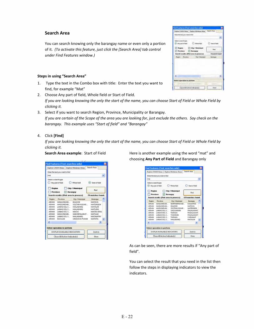
Search Area
You can search knowing only the barangay name or even only a portion of it. (To activate this feature, just click the [Search Area] tab control under Find Features window.)
Steps in using “Search Area”
1. Type the text in the Combo box with title: Enter the text you want to find, for example “Mat”
2. Choose Any part of field, Whole field or Start of Field. If you are looking knowing the only the start of the name, you can choose Start of Field or Whole Field by clicking it.
3. Select if you want to search Region, Province, Municipality or Barangay. If you are certain of the Scope of the area you are looking for, just exclude the others. Say check on the barangay. This example uses “Start of field” and “Barangay”
4. Click [Find] If you are looking knowing the only the start of the name, you can choose Start of Field or Whole Field by clicking it. Search Area example: Start of Field
Here is another example using the word “mat” and choosing Any Part of Field and Barangay only
As can be seen, there are more results if “Any part of field”.
You can select the result that you need in the list then follow the steps in displaying indicators to view the indicators.
E - 22

Here is another example using the word “mat” and choosing Whole Field and Barangay only
As can be seen, there is no barangay with the name “Mat”.
5. Then either [Zoom To] or [Display Available Indicators]
The screen below is the result in displaying indicators such as ethnic compostion, health and electricity for “Mataya, Buldon, Maguindnaao”
Note: If Display Available Indicators is selected and no indicator is recorded in the GIS, the following screen appears.
E - 23

2. Querying the GIS for Some Indicators Querying map data is used to determine which barangay has or does not have a particular indicator, based on the Barangay Profiling Database. To find features, you click the [Query Map Data] icon on the toolbar. (Close all active windows and zoom to full extent first)
This is the Query Map Data window facility.
You can select different functions 3.1 Display Queries in Map: this function will display data in map format. 3.2 Get Data from Queries: this function will display data in tabular format. 3.3 Define New Query: this function will create new queries. 3.4 Modify Query: this function will modify existing query.
Display Queries in Map: this function will display data in map format.
Get Data from Queries: this function will display data in
Define New Query: this function will create new queries.
Modify Query: this function will modify existing query.
E - 24
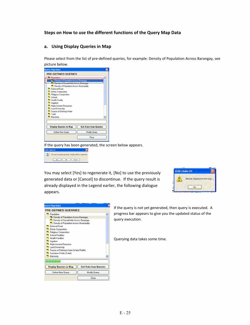
Steps on How to use the different functions of the Query Map Data a. Using Display Queries in Map Please select from the list of pre‐defined queries, for example: Density of Population Across Barangay, see picture below.
If the query has been generated, the screen below appears.
You may select [Yes] to regenerate it, [No] to use the previously generated data or [Cancel] to discontinue. If the query result is already displayed in the Legend earlier, the following dialogue appears.
If the query is not yet generated, then query is executed. A progress bar appears to give you the updated status of the query execution.
Querying data takes some time.
E - 25

After successful execution, the screen like the one below appears.
If the size of the map is too small, you can use “Zoom in” to enlarge, or if too large, you can use “Zoom out” to reduce the size. To return to previous map extent, choose “Zoom to previous map extent” b. Using Get Data from Queries
If the query has been generated, the screen appears. Please select [Yes].
This screen below appears
Click the [PRINT] button to print the query results. This screen appears:
c. Using Define New Queries
Each different user has unique information needs. The software allows these need to be met using the [Define New Query].
The new shape file is displayed in the Legends/Table of Contents
E - 26

Steps to Define New Query:
c.1 This is the main screen when creating or defining new queries.
c.2 Click the group indicator, after you select, list of sub‐indicators will appears, see screen below:
c.3 Select sub‐indicators as many as you wish to match your criteria. You can select by clicking the available
indicators, then click [ADD] button. In this example, you can select more than one sub‐indicator by holding the [CTRL] keyboard and then select sub‐indicator by clicking the mouse.
c.4 After you clicked the [ADD] button, this result appeared. You can select or add again new indicators by clicking the group indicators.
c.5 Adding new group or sub‐indicators, click the group indicators again the select sub‐indicators, then click [ADD] or [ADD ALL] button.
c.6 After selecting all the necessary indicators, this screen appears, you can change expression and provide values:
E - 27

c.7 Manipulating and filling the default conditional values of each selected indicators by clicking value expression as shown below:
c.8 Manipulating and filling the default conditional values of each selected indicators by clicking value box as shown below:
c.9 After completion of selecting indicators, click the [NEX] button to proceed to the other option.
c.10 This screen should appear after clicking [NEXT[ button.
c.11 Click the [Run Query] button to check your queries if data exists.
c.12 Change the Scope of Area, the Group Indicator and also the query title.
Note: you can change the default coloring scheme of the map by selecting from type of Map Coloring Scheme such as single color, continuous ramp, equal breaks and unique values and try also to change the color. See the Changing Coloring Scheme topics to see the detailed steps.
E - 28

c. 15 After those steps, Click [Generate and Display in Map] button. Just minimize the Advance Query Window to see the full screen results)
The Newly created query is displayed like the screen below.
c. 16 After you satisfied on your queries, click [Save] button to save your new queries.
The newly createdshape file is added to map and legend
The newly createdshape file is added to list of PRE‐DEFINED QUERIES.
E - 29

3. Changing the Coloring Scheme Some information can be displayed better using a particular color. Also different users have different preferences.
Steps to Change Color Scheme
1. Right click on the Layer.
The screen below appears
2. Click Properties
Screen below appears
3. Select Coloring Scheme
4. Click the Edit Button
5. The following screen appears
6. Click the Scheme Option button like the one below.
7. Try Continuous Ramp Scheme, see below
Sample results for Continuous Ramp Scheme.
After you satisfied with color scheme, then click [Apply] or [OK] button.
E - 30

8. Try Equal Breaks Scheme, enter how many breaks color.
Sample results for Equal Breaks Scheme.
Sample results for Unique Value Scheme.
After the modifying the Coloring Scheme, the Full Screen as displayed
E - 31

4. Project Listing and Mapping
This feature is an additional datum included in the GIS for project listing of different programs.
To activate this feature, just click this icon on the toolbar to see the screen below.
Check box to select the project(s) to process
Select region from combo box to filter or limit the project lists
Select project type from combo box to filter or limit the project lists
Use to display project(s) list by selecting projects from table.
Use to display individual project(s) in the map
Close all active list from the map
Print the entire project list
Select All
Unselect
E - 32

Steps on how to use project(s) list Select / check the project needed to be displayed in map from the project(s) list, see sample screen below
Using [Display Selected List of Project(s) in Map] Sample results of this function.
E - 33

Using [Display Selected Individual Project(s) in Map] Sample results of this function.
Using [Print the Project(s) List] Sample results of this function.
E - 34

Part IV: Working with the Layers A layer is set of information that can have one or more shape file associated with it. A shape file can be made of point, lines or polygons. It can also be a normal graphics such as JPG or BMP, with projections associated with it.
Layers can be visible or not. It can also be added or removed. If the layer is visible, there is a Check before its name, otherwise, no check.
Population profile is not visible while the CAAM Barangays and National Roads are visible
E - 35

1. Most Common Shape file Operation The most common shape file operations as add, remove, rename, picture, fill, line and transparency. If you right click the Shape file in the Legends, the following screen appears
To see this menu, right click on the Table of Contents / Legend Panel.
Polygon Shape file To work on the shape file properties at once, Click Properties. The Legend Editor screen like the one below appears for polygon shape file. The meanings of each property items are mostly self explanatory and are also described in the information area of the screen.
You can change the properties on all those active items, in this case, Coloring Scheme, Display Name, Dynamic Visibility, Fill Color, and all the rest. Those grey areas on top are not editable, but serve to inform the user on
important information about the shape file .
To see this menu, right click on the Table of Contents / Legend Panel then select properties.
E - 36

Line shape file Line shape file represent items such as roads, tracks and similar shapes. If the shape file is a made of lines, fill color does not exist.
To see this menu, right click on the Table of Contents / Legend Panel then select properties..
Point Shape File
If the shape file is made of points, such as locations of wells, buildings, marks and similar map items. For point shape files, the following properties screen appears.
Property items such as Legend Picture, Point Color, Point Style, Point Size and added and some property items used for lines and polygons are absent.
To see this menu, right click on the Table of Contents / Legend Panel then select properties..
E - 37
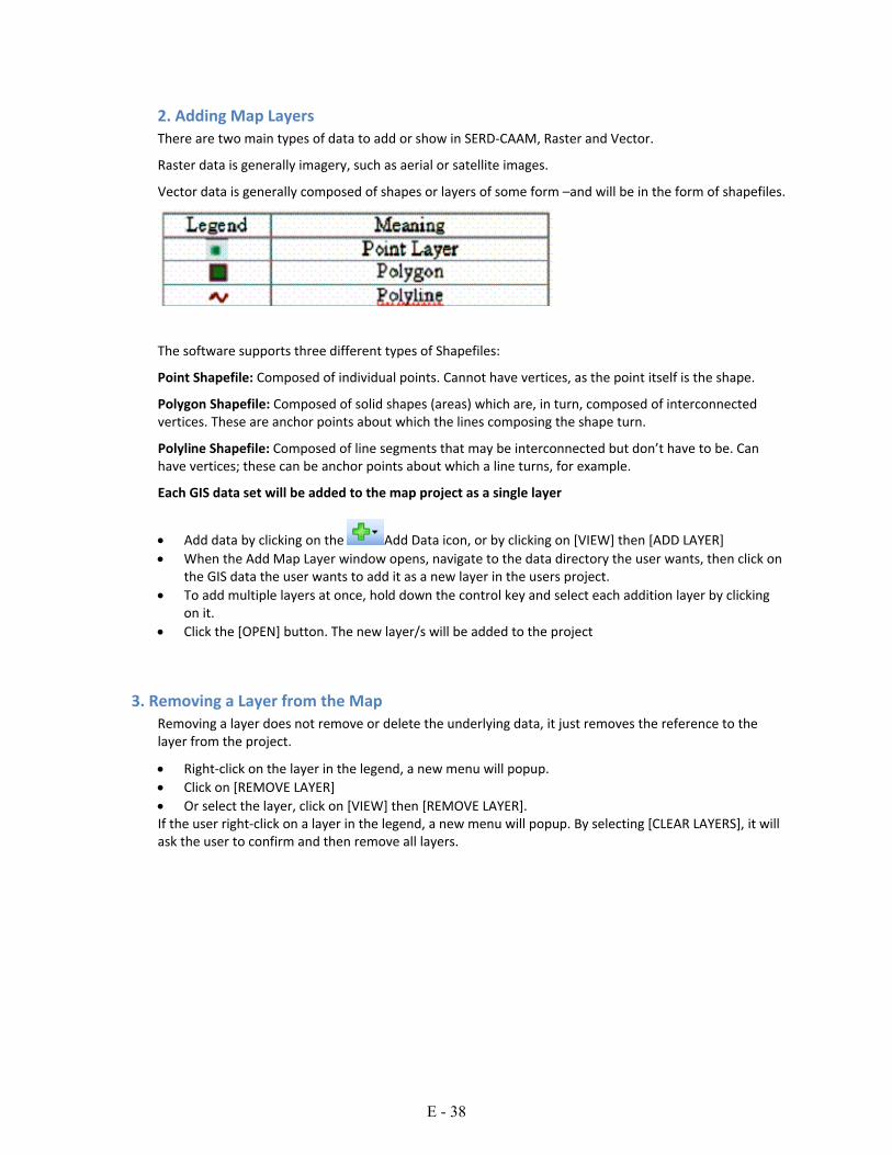
2. Adding Map Layers There are two main types of data to add or show in SERD‐CAAM, Raster and Vector.
Raster data is generally imagery, such as aerial or satellite images.
Vector data is generally composed of shapes or layers of some form –and will be in the form of shapefiles.
The software supports three different types of Shapefiles:
Point Shapefile: Composed of individual points. Cannot have vertices, as the point itself is the shape.
Polygon Shapefile: Composed of solid shapes (areas) which are, in turn, composed of interconnected vertices. These are anchor points about which the lines composing the shape turn.
Polyline Shapefile: Composed of line segments that may be interconnected but don’t have to be. Can have vertices; these can be anchor points about which a line turns, for example.
Each GIS data set will be added to the map project as a single layer
• Add data by clicking on the Add Data icon, or by clicking on [VIEW] then [ADD LAYER] • When the Add Map Layer window opens, navigate to the data directory the user wants, then click on
the GIS data the user wants to add it as a new layer in the users project. • To add multiple layers at once, hold down the control key and select each addition layer by clicking
on it. • Click the [OPEN] button. The new layer/s will be added to the project
3. Removing a Layer from the Map Removing a layer does not remove or delete the underlying data, it just removes the reference to the layer from the project.
• Right‐click on the layer in the legend, a new menu will popup. • Click on [REMOVE LAYER] • Or select the layer, click on [VIEW] then [REMOVE LAYER]. If the user right‐click on a layer in the legend, a new menu will popup. By selecting [CLEAR LAYERS], it will ask the user to confirm and then remove all layers.
E - 38

4. Using the Legend to Control the Layers The legend is a graphical representation of all the map layers in the current project. The position of the legend is the left hand side of the screen. The legend offers layer manipulation functionality including but not limited to changing a layers symbology or the order of display for the layers. The legend is always displayed
• Visibility Checkbox: This indicates whether a layer is always
visible (checked) on the map screen, or always hidden (blank). • Text: This is the name of the layer. Each line represents a layer of data that’s in the main view. The image to the right of the legend is an indicator to help identify the data layer. If, for example, the user had a polygon Shapefile that was filled, the Color in this image would be the same as the fill Color. For a line Shapefile, the Color here will match the Color the line is drawn with.
Right Click Functionality If users right click (right mouse button) over the Legend, the menu below shows;
[ADD GROUP] bunch a selected set of layers under a common header
[ADD LAYER]
[REMOVE LAYER] – Removes a layer from the project
[CLEAR LAYERS] ‐ Removes all layers
[ZOOM TO LAYER] ‐ Zooms the map to the full extent of the selected layer
[VIEW METADATA]
[VIEW ATTRIBUTE TABLE] – this is the table behind most layers which can contain a range of information on shapes, such as names, size, x & y coordinates etc.
[EXPAND GROUP] [EXPAND ALL] [COLLAPSE GROUP] [COLLAPSE ALL]
[PROPERTIES]
E - 39

5. Changing the Drawing Order: The legend indicates the order that layers are drawn in. The first layer in the legend is the top layer of the map. The last layer in the legend is the bottom layer on the map. The layers are drawn from bottom up, hence the bottom layer is drawn first then the last but one layer and so on. As a result is it important to carefully order the users map layers so data is not obscured by layers placed on top.
If you have imagery displayed, this is best ordered to the bottom of the layer list, to make it background for all other layers on top.
To change the order of a layer, in the legend, click and drag a layer to the desired location.
6. Using Groups to Order Layers If you have large numbers of layers loaded, the legend can become cluttered and require users to scroll up and down to find the relevant layers. The Group option allows you to bunch layers together, and expand or collapse this group or re‐order a whole group of layers.
To add a new Group;
• Right‐click on the Legend and select [ADD GROUP]
• Name the Group in the dialog and confirm
To add layers into a Group;
• Select the appropriate Group you want to add layers to
• Add the layers as per normal, or click and drag existing layers into the group from other sections of the legend
7. Changing the Layer Display properties. Changing the properties of a layer does not affect the underlying data. The layer properties are project dependent and will not modify any information stored against the map source. However, on first use of a layer where display properties are set, this will create a new file with .mwsr extension. This will become the default display for any further uses of this layer, unless these properties are defined in the Project file, which will override these.
To change the layer properties, double‐click on the layer in the legend and the Legend Editor appears ;
• Coloring Scheme ‐ allows users to use colors to distinguish between features in a shapefile based on a field in the attributes..
• Display Name box. If text is changed, this will be the new layer name displayed in the legend and on printed maps, but will not alter the layer filename.
• Fill Color – click on the colored box to open a color chart to change the fill color for polygon shapes
• Fill Style – can be used to select hatched or lined fill • Label Setup – can be used to set characteristics of labels • Line Style – use this to change the style of lines for line shapes • Line Width – change how thick a line will display. • Outline Color – can change the outline for a polygon to the same or different Color as the Fill Color.
• Show Fill – this will turn the fill Color on (true) or off (false) for polygons. To have a clear polygon, select False.
• Transparency Percent – sets how transparent the fill for polygons can be – 0 means the fill will block everything behind it. Higher number will allow items behind the fill to show through.
• Click the [X] button to close the Layer Properties dialog. The legend will update to show the new layer properties.
E - 40

Then save the users project
8. Making the Layer Scalable Making a layer scalable will result in a layer not showing on a map until the user has zoomed into a particular scale. This is useful for layers that show far too much detail when viewing an entire area, such as property boundaries, but are useful when zoomed in. To do this:
• Zoom into the scale that the user want the desired layer to appear • Double click on the layer in the legend • Click the Dynamic Visibility Disabled line and a drop‐down arrow will appear. Click on the drop‐down
arrow • Put a check in (Use Dynamic Visibility) Click on the drop‐down arrow again • Click the [USE CURRENT EXTENT] button • Close the Legend Editor. NOTE: If the user sets up a dynamic visibility, and then unselect the layer in the legend, it will reset the dynamic visibility to disabled. This means the user will have to reset it again.
9. Adding a Label to a Layer Labels are an easy way to add dynamic textual labels to geometry features on the map. The system will extract a field from the map data to be used as the label text, with up to two label fields per layer.
To add labels to a layer;
• Double Click on the layer in the legend window. • Click on Label Setup
• Click on the button right of Edit on the Label Setup line.
• Select the (Label Field for First Line) drop‐down and select the field to label with. • Select the (Label Field for Second Line) drop‐down and select the secondary label field. • Change the Color if required, and select Use Label Shadow if required • Click [Apply] to check how these changes look, then [OK], or just [OK].
E - 41

To remove the labeling for a layer, set the (Label Field for First Line) values to none.
Click OK to close the window, and labels will disappear.
NOTE: When a layer is given a label for the first time, a file with the extension .lbl will be created with the layer files. This will act as the default labeling scheme for future use of the layer, but will be overridden by the Project file.
10. Changing a Layer Coloring Scheme The Coloring Scheme allows user to distinguish between features in a layer using different fill colors.
To enable a color scheme;
• Open Legend editor by double clicking on the layer in the legend
• Click on Coloring Scheme, then click on the icon at right, the color schema editor box will appear
• Select the field in attributes to differentiate color on
• Select the number format which suits, or if text fields select Automatic
• Click on the predefined schema icon
at the top of the box and select from the options, or use the add icon to specify colors for each class
• Click Apply or OK to accept the schema
E - 42

11. Display and Modify Map Scale Bar The Floating Scale Bar will automatically show the map scale, modifying as users zoom in and out. To show the Floating Scale Bar on maps:
• Click [View] then click on [Show Floating Scale Bar] Users can modify the Scale Bar display, ie units, Color, text size and location on the map.
To modify Scale Bar display;
• right click on the Scale Bar to open a new menu • select from display options and select settings you wish.
12. Moving Around a Map When working with a map it may be necessary to zoom in to view an area in more detail, or zoom out to see a larger area, or pan to move the view around.
If the users mouse has a scroll wheel on top, it can be used to zoom in by rolling it forward, or zoom out by rolling backward.
Zooming In
• Click the [ZOOM IN] button on the Tools toolbar, move the mouse over the map, single click to zoom in around a point.
• Zoom in to a specific area. Click and hold the left mouse. Move the mouse to drag a rectangle to create the area the user wish to zoom to. Release the mouse button to complete the zoom.
• When in Zoom Out mode, a right‐click on the mouse will zoom in.
Zooming Out
• Click the [ZOOM OUT] button on the Tools Toolbar, move the mouse over the map. Single Click to zoom out around a point
• When in Zoom In mode, a right‐click on the mouse will Zoom Out
E - 43

Zooming to Full Extent
Zooming to full extent resets the map view so that every feature of very layer is contained within the visible extent
• Click the [Zoom To Full Extents] button on the Tools toolbar
Zoom to Layer Extent
Zoom to a layers extent will set the map display to an area just big enough to show every feature in the currently selected layer.
• Right‐click on the layer in the legend, a new menu opens. Click on [ZOOM TO LAYER] or
• Click the [Zoom To Active Layer] button on the main toolbar .
Panning
Panning allows the user to move the map display around to show areas outside of the current viewing area without changing the scale of the map.
• Click the Pan button on the Tools toolbar. • Move the mouse over the map. • Click and hold down the left mouse button. • Move the mouse, still holding down the mouse button. The map will move with the mouse. • Release the mouse button to complete the pan operation ‐ Pan (move view)
13. Measuring Shapes
Measuring distance
The distance measurement tool is used to calculate distances between two or more user‐defined points on the map.
• Click on the [MEASURE DISTANCE] Tool • Click on the first point • Click on the next point • On the bottom left of the main application window, the cumulative distance is displayed. Continue to
click on subsequent points, or right Click to start over again with new measurement. • Click the button again to unselect it and leave Measure mode.
Measuring Area
The area measurement tool is used to calculate the area between three or more user‐defined points on the map.
• Click on the [MEASURE AREA] Tool • Click on the first point, click on the next point and as many points as needed to complete the border
around the area needed to be measured • Right Click to end and see the results of the area measured. • Click [OK] to finish measuring and resume map functions.
E - 44

Part V: Appendices
Appendix A: Overview of Mapwindow www.mapwindow.org/overview.php
MapWindow is an open source "Programmable Geographic Information System" that supports manipulation, analysis, and viewing of geospatial data and associated attribute data in several standard GIS data formats. MapWindow is a mapping tool, a GIS modeling system, and a GIS application programming interface (API) all in one convenient redistributable open source form. MapWindow was developed to address the need for a GIS programming tool that could be used in engineering research and project software, without requiring end users to purchase a complete GIS system, or become GIS experts. Appendix B:
Why MapWindow?
http://www.mapwindow.org/why.php
May 27, 2009
To Whom It May Concern:
Several people have inquired as to why MapWindow was developed. Hopefully this will help answer the question.
In 1998, I was part of a group of researchers at the Utah Water Research Lab in Logan, Utah where we began doing map‐based modeling and map‐enabled projects using MapObjects LT 1.0 from ESRI. As it turned out, we ran into some major road blocks with MapObjects LT 1.0. The problem for us was the inability to access or modify any of the underlying spatial or tabular data directly through code (i.e. edit the ".shp" file or the ".dbf" file.) Also we could not display or interact with grid data.
In one project, we wanted to allow a user to select a shape on the map (e.g. a land parcel) and dynamically modify it by clicking on the map and dragging one of the points to a new location. In another project, we wanted to allow a user to watch a scenario progress over time showing the location of a stream shifting. We also had several projects that needed much more direct access to the DBF data accompanying the shapefiles and to grid data in various formats. For example we were working on a watershed delineation tool that wouldn't require use of any commercial spatial data analysis module.
These kind of highly dynamic, interactive and grid‐oriented functions that require low level access to shape, tabular and grid data were not well‐supported in any of the existing GIS programming components that we identified. One alternative was to move to a desk‐top GIS system, and write our tools as extensions. However, there are many applications, particularly environmental science and engineering applications that are more suited to a stand alone environment because of the need to distribute the tool to individuals who do not own a desktop GIS and are not GIS experts.
E - 45

As a result of these issues and other issues, we developed the core MapWinGIS.ocx component as an alternative to existing GIS programming components. MapWinGIS.ocx is an ActiveX control that can be dropped on a VB form giving full ability to display, query, manipulate, and otherwise use spatial data.
Our development team at USU was in a particularly good position to develop MapWinGIS.ocx, because of our access to both engineers and computer scientists. As such, we worked to optimize MapWinGIS.ocx for use as a fully functional model interface, not just as a map viewer. This involved speeding up image and grid display, limiting the amount of re‐drawing that the user sees, and including application programmer interfaces (APIs) for low‐level access to grid, shape, table, image and 3‐D triangulated (TIN) data.
Now you may be wondering why we also built the MapWindow application... If so, please read on...
In several of the GIS‐enabled projects that drove the need for MapWinGIS.ocx, we found that we were constantly re‐writing legend tools, toolbar navigation, and project management. Also, we found that sometimes we wanted to deploy an application quickly and easily that used some combination of functionality written for other projects.
For example, the 3‐D TIN viewer was a useful tool for both the Avalanche Hazard Mapper, and some customized watershed data viewers. Rather than embed the 3‐D TIN viewer code in both applications, we designed a "plug‐in" architecture and a customizable GIS application that could be used to quickly assemble different applications using different pre‐built "building blocks".
In short, the MapWinGIS.ocx ActiveX control was built to support GIS functions in totally unique GIS‐enabled applications, and the MapWindow application was built to help users deploy GIS‐enabled applications that can be assembled from pre‐built plug‐ins and data sets.
Thanks,
Daniel P. Ames, PhD www.Hydromap.com
Addendum
In Fall 2004, I took a position at Idaho State University as the director of academic programs in geographic information science. As part of this move, I have been working to organize the MapWindow Open Source team to continue to develop and deploy MapWindow tools under the Mozilla Public License 1.1.
E - 46

Appendix C:
MapWindow is Open Source Software
http://www.mapwindow.org/opensource.php
The Mozilla Public License 1.1 applies to all MapWindow GIS source code. This license was developed by Netscape Communications and is recommended by the Open Source Initiative (http://www.opensource.org/).
1. Definitions.
1.0.1. "Commercial Use" means distribution or otherwise making the Covered Code available to a third party.
1.1. ''Contributor'' means each entity that creates or contributes to the creation of Modifications.
1.2. ''Contributor Version'' means the combination of the Original Code, prior Modifications used by a Contributor, and the Modifications made by that particular Contributor.
1.3. ''Covered Code'' means the Original Code or Modifications or the combination of the Original Code and Modifications, in each case including portions thereof.
1.4. ''Electronic Distribution Mechanism'' means a mechanism generally accepted in the software development community for the electronic transfer of data.
1.5. ''Executable'' means Covered Code in any form other than Source Code.
1.6. ''Initial Developer'' means the individual or entity identified as the Initial Developer in the Source Code notice required by Exhibit A.
1.7. ''Larger Work'' means a work which combines Covered Code or portions thereof with code not governed by the terms of this License.
1.8. ''License'' means this document.
1.8.1. "Licensable" means having the right to grant, to the maximum extent possible, whether at the time of the initial grant or subsequently acquired, any and all of the rights conveyed herein.
1.9. ''Modifications'' means any addition to or deletion from the substance or structure of either the Original Code or any previous Modifications. When Covered Code is released as a series of files, a Modification is:
A. Any addition to or deletion from the contents of a file containing Original Code or previous Modifications.
B. Any new file that contains any part of the Original Code or previous Modifications.
E - 47

1.10. ''Original Code'' means Source Code of computer software code which is described in the Source Code notice required by Exhibit A as Original Code, and which, at the time of its release under this License is not already Covered Code governed by this License.
1.10.1. "Patent Claims" means any patent claim(s), now owned or hereafter acquired, including without limitation, method, process, and apparatus claims, in any patent Licensable by grantor.
1.11. ''Source Code'' means the preferred form of the Covered Code for making modifications to it, including all modules it contains, plus any associated interface definition files, scripts used to control compilation and installation of an Executable, or source code differential comparisons against either the Original Code or another well known, available Covered Code of the Contributor's choice. The Source Code can be in a compressed or archival form, provided the appropriate decompression or de‐archiving software is widely available for no charge.
1.12. "You'' (or "Your") means an individual or a legal entity exercising rights under, and complying with all of the terms of, this License or a future version of this License issued under Section 6.1. For legal entities, "You'' includes any entity which controls, is controlled by, or is under common control with You. For purposes of this definition, "control'' means (a) the power, direct or indirect, to cause the direction or management of such entity, whether by contract or otherwise, or (b) ownership of more than fifty percent (50%) of the outstanding shares or beneficial ownership of such entity.
2. Source Code License.
2.1. The Initial Developer Grant. The Initial Developer hereby grants You a world‐wide, royalty‐free, non‐exclusive license, subject to third party intellectual property claims:
(a) under intellectual property rights (other than patent or trademark) Licensable by Initial Developer to use, reproduce, modify, display, perform, sublicense and distribute the Original Code (or portions thereof) with or without Modifications, and/or as part of a Larger Work; and
(b) under Patents Claims infringed by the making, using or selling of Original Code, to make, have made, use, practice, sell, and offer for sale, and/or otherwise dispose of the Original Code (or portions thereof).
(c) the licenses granted in this Section 2.1(a) and (b) are effective on the date Initial Developer first distributes Original Code under the terms of this License.
(d) Notwithstanding Section 2.1(b) above, no patent license is granted: 1) for code that You delete from the Original Code; 2) separate from the Original Code; or 3) for infringements caused by: i) the modification of the Original Code or ii) the combination of the Original Code with other software or devices.
2.2. Contributor Grant. Subject to third party intellectual property claims, each Contributor hereby grants You a world‐wide, royalty‐free, non‐exclusive license
(a) under intellectual property rights (other than patent or trademark) Licensable by Contributor, to use, reproduce, modify, display, perform, sublicense and distribute the Modifications created
E - 48

by such Contributor (or portions thereof) either on an unmodified basis, with other Modifications, as Covered Code and/or as part of a Larger Work; and
(b) under Patent Claims infringed by the making, using, or selling of Modifications made by that Contributor either alone and/or in combination with its Contributor Version (or portions of such combination), to make, use, sell, offer for sale, have made, and/or otherwise dispose of: 1) Modifications made by that Contributor (or portions thereof); and 2) the combination of Modifications made by that Contributor with its Contributor Version (or portions of such combination).
(c) the licenses granted in Sections 2.2(a) and 2.2(b) are effective on the date Contributor first makes Commercial Use of the Covered Code.
(d) Notwithstanding Section 2.2(b) above, no patent license is granted: 1) for any code that Contributor has deleted from the Contributor Version; 2) separate from the Contributor Version; 3) for infringements caused by: i) third party modifications of Contributor Version or ii) the combination of Modifications made by that Contributor with other software (except as part of the Contributor Version) or other devices; or 4) under Patent Claims infringed by Covered Code in the absence of Modifications made by that Contributor.
3. Distribution Obligations.
3.1. Application of License. The Modifications which You create or to which You contribute are governed by the terms of this License, including without limitation Section 2.2. The Source Code version of Covered Code may be distributed only under the terms of this License or a future version of this License released under Section 6.1, and You must include a copy of this License with every copy of the Source Code You distribute. You may not offer or impose any terms on any Source Code version that alters or restricts the applicable version of this License or the recipients' rights hereunder. However, You may include an additional document offering the additional rights described in Section 3.5.
3.2. Availability of Source Code. Any Modification which You create or to which You contribute must be made available in Source Code form under the terms of this License either on the same media as an Executable version or via an accepted Electronic Distribution Mechanism to anyone to whom you made an Executable version available; and if made available via Electronic Distribution Mechanism, must remain available for at least twelve (12) months after the date it initially became available, or at least six (6) months after a subsequent version of that particular Modification has been made available to such recipients. You are responsible for ensuring that the Source Code version remains available even if the Electronic Distribution Mechanism is maintained by a third party.
3.3. Description of Modifications. You must cause all Covered Code to which You contribute to contain a file documenting the changes You made to create that Covered Code and the date of any change. You must include a prominent statement that the Modification is derived, directly or indirectly, from Original Code provided by the Initial Developer and including the name of the Initial Developer in (a) the Source Code, and (b) in any notice in an Executable version or related documentation in which You describe the origin or ownership of the Covered Code.
3.4. Intellectual Property Matters
E - 49

(a) Third Party Claims. If Contributor has knowledge that a license under a third party's intellectual property rights is required to exercise the rights granted by such Contributor under Sections 2.1 or 2.2, Contributor must include a text file with the Source Code distribution titled "LEGAL'' which describes the claim and the party making the claim in sufficient detail that a recipient will know whom to contact. If Contributor obtains such knowledge after the Modification is made available as described in Section 3.2, Contributor shall promptly modify the LEGAL file in all copies Contributor makes available thereafter and shall take other steps (such as notifying appropriate mailing lists or newsgroups) reasonably calculated to inform those who received the Covered Code that new knowledge has been obtained.
(b) Contributor APIs. If Contributor's Modifications include an application programming interface and Contributor has knowledge of patent licenses which are reasonably necessary to implement that API, Contributor must also include this information in the LEGAL file.
(c) Representations.
Contributor represents that, except as disclosed pursuant to Section 3.4(a) above, Contributor believes that Contributor's Modifications are Contributor's original creation(s) and/or Contributor has sufficient rights to grant the rights conveyed by this License.
3.5. Required Notices. You must duplicate the notice in Exhibit A in each file of the Source Code. If it is not possible to put such notice in a particular Source Code file due to its structure, then You must include such notice in a location (such as a relevant directory) where a user would be likely to look for such a notice. If You created one or more Modification(s) You may add your name as a Contributor to the notice described in Exhibit A. You must also duplicate this License in any documentation for the Source Code where You describe recipients' rights or ownership rights relating to Covered Code. You may choose to offer, and to charge a fee for, warranty, support, indemnity or liability obligations to one or more recipients of Covered Code. However, You may do so only on Your own behalf, and not on behalf of the Initial Developer or any Contributor. You must make it absolutely clear than any such warranty, support, indemnity or liability obligation is offered by You alone, and You hereby agree to indemnify the Initial Developer and every Contributor for any liability incurred by the Initial Developer or such Contributor as a result of warranty, support, indemnity or liability terms You offer.
3.6. Distribution of Executable Versions. You may distribute Covered Code in Executable form only if the requirements of Section 3.1‐3.5 have been met for that Covered Code, and if You include a notice stating that the Source Code version of the Covered Code is available under the terms of this License, including a description of how and where You have fulfilled the obligations of Section 3.2. The notice must be conspicuously included in any notice in an Executable version, related documentation or collateral in which You describe recipients' rights relating to the Covered Code. You may distribute the Executable version of Covered Code or ownership rights under a license of Your choice, which may contain terms different from this License, provided that You are in compliance with the terms of this License and that the license for the Executable version does not attempt to limit or alter the recipient's rights in the Source Code version from the rights set forth in this License. If You distribute the Executable version under a different license You must make it absolutely clear that any terms which differ from this License are offered by You alone, not by the Initial Developer or any Contributor. You hereby agree to indemnify the Initial Developer and every Contributor for any liability incurred by the Initial Developer or such Contributor as a result of any such terms You offer.
E - 50

3.7. Larger Works. You may create a Larger Work by combining Covered Code with other code not governed by the terms of this License and distribute the Larger Work as a single product. In such a case, You must make sure the requirements of this License are fulfilled for the Covered Code.
4. Inability to Comply Due to Statute or Regulation.
If it is impossible for You to comply with any of the terms of this License with respect to some or all of the Covered Code due to statute, judicial order, or regulation then You must: (a) comply with the terms of this License to the maximum extent possible; and (b) describe the limitations and the code they affect. Such description must be included in the LEGAL file described in Section 3.4 and must be included with all distributions of the Source Code. Except to the extent prohibited by statute or regulation, such description must be sufficiently detailed for a recipient of ordinary skill to be able to understand it.
5. Application of this License.
This License applies to code to which the Initial Developer has attached the notice in Exhibit A and to related Covered Code.
6. Versions of the License.
6.1. New Versions. Netscape Communications Corporation (''Netscape'') may publish revised and/or new versions of the License from time to time. Each version will be given a distinguishing version number.
6.2. Effect of New Versions. Once Covered Code has been published under a particular version of the License, You may always continue to use it under the terms of that version. You may also choose to use such Covered Code under the terms of any subsequent version of the License published by Netscape. No one other than Netscape has the right to modify the terms applicable to Covered Code created under this License.
6.3. Derivative Works. If You create or use a modified version of this License (which you may only do in order to apply it to code which is not already Covered Code governed by this License), You must (a) rename Your license so that the phrases ''Mozilla'', ''MOZILLAPL'', ''MOZPL'', ''Netscape'', "MPL", ''NPL'' or any confusingly similar phrase do not appear in your license (except to note that your license differs from this License) and (b) otherwise make it clear that Your version of the license contains terms which differ from the Mozilla Public License and Netscape Public License. (Filling in the name of the Initial Developer, Original Code or Contributor in the notice described in Exhibit A shall not of themselves be deemed to be modifications of this License.)
7. DISCLAIMER OF WARRANTY.
COVERED CODE IS PROVIDED UNDER THIS LICENSE ON AN "AS IS'' BASIS, WITHOUT WARRANTY OF ANY KIND, EITHER EXPRESSED OR IMPLIED, INCLUDING, WITHOUT LIMITATION, WARRANTIES THAT THE COVERED CODE IS FREE OF DEFECTS, MERCHANTABLE, FIT FOR A PARTICULAR PURPOSE OR NON‐INFRINGING. THE ENTIRE RISK AS TO THE QUALITY AND PERFORMANCE OF THE COVERED CODE IS WITH YOU. SHOULD ANY COVERED CODE PROVE DEFECTIVE IN ANY RESPECT, YOU (NOT THE INITIAL DEVELOPER OR ANY OTHER CONTRIBUTOR) ASSUME THE COST OF ANY NECESSARY SERVICING, REPAIR OR CORRECTION. THIS DISCLAIMER OF WARRANTY CONSTITUTES AN ESSENTIAL PART OF THIS LICENSE. NO USE OF ANY COVERED CODE IS AUTHORIZED HEREUNDER EXCEPT UNDER THIS DISCLAIMER.
E - 51

8. TERMINATION.
8.1. This License and the rights granted hereunder will terminate automatically if You fail to comply with terms herein and fail to cure such breach within 30 days of becoming aware of the breach. All sublicenses to the Covered Code which are properly granted shall survive any termination of this License. Provisions which, by their nature, must remain in effect beyond the termination of this License shall survive.
8.2. If You initiate litigation by asserting a patent infringement claim (excluding declatory judgment actions) against Initial Developer or a Contributor (the Initial Developer or Contributor against whom You file such action is referred to as "Participant") alleging that:
(a) such Participant's Contributor Version directly or indirectly infringes any patent, then any and all rights granted by such Participant to You under Sections 2.1 and/or 2.2 of this License shall, upon 60 days notice from Participant terminate prospectively, unless if within 60 days after receipt of notice You either: (i) agree in writing to pay Participant a mutually agreeable reasonable royalty for Your past and future use of Modifications made by such Participant, or (ii) withdraw Your litigation claim with respect to the Contributor Version against such Participant. If within 60 days of notice, a reasonable royalty and payment arrangement are not mutually agreed upon in writing by the parties or the litigation claim is not withdrawn, the rights granted by Participant to You under Sections 2.1 and/or 2.2 automatically terminate at the expiration of the 60 day notice period specified above.
(b) any software, hardware, or device, other than such Participant's Contributor Version, directly or indirectly infringes any patent, then any rights granted to You by such Participant under Sections 2.1(b) and 2.2(b) are revoked effective as of the date You first made, used, sold, distributed, or had made, Modifications made by that Participant.
8.3. If You assert a patent infringement claim against Participant alleging that such Participant's Contributor Version directly or indirectly infringes any patent where such claim is resolved (such as by license or settlement) prior to the initiation of patent infringement litigation, then the reasonable value of the licenses granted by such Participant under Sections 2.1 or 2.2 shall be taken into account in determining the amount or value of any payment or license.
8.4. In the event of termination under Sections 8.1 or 8.2 above, all end user license agreements (excluding distributors and resellers) which have been validly granted by You or any distributor hereunder prior to termination shall survive termination.
9. LIMITATION OF LIABILITY.
UNDER NO CIRCUMSTANCES AND UNDER NO LEGAL THEORY, WHETHER TORT (INCLUDING NEGLIGENCE), CONTRACT, OR OTHERWISE, SHALL YOU, THE INITIAL DEVELOPER, ANY OTHER CONTRIBUTOR, OR ANY DISTRIBUTOR OF COVERED CODE, OR ANY SUPPLIER OF ANY OF SUCH PARTIES, BE LIABLE TO ANY PERSON FOR ANY INDIRECT, SPECIAL, INCIDENTAL, OR CONSEQUENTIAL DAMAGES OF ANY CHARACTER INCLUDING, WITHOUT LIMITATION, DAMAGES FOR LOSS OF GOODWILL, WORK STOPPAGE, COMPUTER FAILURE OR MALFUNCTION, OR ANY AND ALL OTHER COMMERCIAL DAMAGES OR LOSSES, EVEN IF SUCH PARTY SHALL HAVE BEEN INFORMED OF THE POSSIBILITY OF SUCH DAMAGES. THIS LIMITATION OF LIABILITY SHALL NOT APPLY TO LIABILITY FOR DEATH OR PERSONAL INJURY RESULTING FROM SUCH PARTY'S NEGLIGENCE TO THE EXTENT APPLICABLE LAW PROHIBITS SUCH LIMITATION. SOME JURISDICTIONS DO NOT ALLOW THE EXCLUSION OR LIMITATION OF INCIDENTAL OR CONSEQUENTIAL DAMAGES, SO THIS EXCLUSION AND LIMITATION MAY NOT APPLY TO YOU.
E - 52

10. U.S. GOVERNMENT END USERS.
The Covered Code is a ''commercial item,'' as that term is defined in 48 C.F.R. 2.101 (Oct. 1995), consisting of ''commercial computer software'' and ''commercial computer software documentation,'' as such terms are used in 48 C.F.R. 12.212 (Sept. 1995). Consistent with 48 C.F.R. 12.212 and 48 C.F.R. 227.7202‐1 through 227.7202‐4 (June 1995), all U.S. Government End Users acquire Covered Code with only those rights set forth herein.
11. MISCELLANEOUS.
This License represents the complete agreement concerning subject matter hereof. If any provision of this License is held to be unenforceable, such provision shall be reformed only to the extent necessary to make it enforceable. This License shall be governed by California law provisions (except to the extent applicable law, if any, provides otherwise), excluding its conflict‐of‐law provisions. With respect to disputes in which at least one party is a citizen of, or an entity chartered or registered to do business in the United States of America, any litigation relating to this License shall be subject to the jurisdiction of the Federal Courts of the Northern District of California, with venue lying in Santa Clara County, California, with the losing party responsible for costs, including without limitation, court costs and reasonable attorneys' fees and expenses. The application of the United Nations Convention on Contracts for the International Sale of Goods is expressly excluded. Any law or regulation which provides that the language of a contract shall be construed against the drafter shall not apply to this License.
12. RESPONSIBILITY FOR CLAIMS.
As between Initial Developer and the Contributors, each party is responsible for claims and damages arising, directly or indirectly, out of its utilization of rights under this License and You agree to work with Initial Developer and Contributors to distribute such responsibility on an equitable basis. Nothing herein is intended or shall be deemed to constitute any admission of liability.
13. MULTIPLE‐LICENSED CODE.
Initial Developer may designate portions of the Covered Code as Multiple‐Licensed. Multiple‐Licensed means that the Initial Developer permits you to utilize portions of the Covered Code under Your choice of the NPL or the alternative licenses, if any, specified by the Initial Developer in the file described in Exhibit A.
EXHIBIT A ‐Mozilla Public License.
``The contents of this file are subject to the Mozilla Public License Version 1.1 (the "License"); you may not use this file except in compliance with the License. You may obtain a copy of the License at http://www.mozilla.org/MPL/
Software distributed under the License is distributed on an "AS IS" basis, WITHOUT WARRANTY OF ANY KIND, either express or implied. See the License for the specificlanguage governing rights and limitations under the License.
E - 53

The Original Code is MapWindow OSS 4.0.
The Initial Developer of the Original Code is Daniel P. Ames. Portions created by Utah State University and the Idaho National Engineering and Environmental Lab were released as public domain in March 2004.
Contributor(s): ______________________________________.
,
E - 54

APPENDICES
APPENDIX F
FLOWCHART OF THE STUDY

APPENDIX F-1: FLOWCHART OF THE STUDY SERD-CAAM STUDY FLOWCHART As of November, 2009
2007 2008Feb March April May June Lujy Aug. Sep. Oct. Nov. Dec. Jan. Feb. Mar. April May June July Aug. Sep. Oct. Nov. Dec. Jan. April May June July Aug. Sep. Oct. Nov.
Fiscal Year
Phase
ReportSubmission
◎ ◎ ◎ ◎ ◎ ◎ ◎ ◎ ◎ ◎▽ ▽ ▽ ▽ ▽ ▽ ▽
◎TWG▽PSC
Year
Major Study Activities
Mar.Feb.2009
Quick Impact Projects(QIPs)
D
iscu
ssio
n o
n IC
/R
First Year Second Year (Phase1)
IC/R PG/R IT/R(Draft)
1st DF/R
Dec
issi
on o
n S
tudy
polic
y
Pre
par
atio
n o
f IC
/R
Barangay Survey-Socio-economic infrastructure-In Depth Barangay Needs Analysis (Phase-1 92 Barangays)→On-the-Spot Assistance(OSA)-Barangay Profile
Analysis of theTarget Araes
Completion of GIS and Atlas Map
In Japan In the Phlippines
Plan andDesign
Implementation- Tender & Contract- Implementation
Formulation of SEDP1st Draft
Preparation of Action Plan FrameWork for SEDP Formulation
Phase I
Phase II
QIP Phase-1Monitoring Monitoring and Evaluation of QIPs Phase Ⅰ& II / Turn-Over
Data Collection and Analysis in the target Area-Profile of Region-Profile of Province -Profile of Municipality
Preparation of Base map and Establshment of GIS database
Social Preparation
Selection of QIP Barangay(Part 1)
Workshop
Implementation (Group-IA)
Social Preparation Phase Ⅱ(Group-IA)
Tender & Design (Group-1)
In the Philippines Study
IC/R(Final)
IT/R(Final)
QIP BarangaySelection(Group-2)
Implementation (Group-2)
Commenton DIT/R
Community basedplan
Preparation ofSEDPFrameWork
WorkShop
Survey on Existing Conditions
Formulation of Action plan and SEDP in CAAM
Tender & Design(Group-2)
Social Preparation Phase Ⅱ(Group-2)
Barangay Profile
Workshop
FinalSEDP
FloodSurvey
Possibility Check
Flood Survey
Data Analysis
Suspention bysecurity reason
2nd DF/R
Formulation of SEDP2nd Draft
Evaluationof tender
Tender & Design( )
Implementation (Grp1B)
Social Preparation(Grp1B)
Social Preparation (Grp1A, 1B)
Second Year (Phase2)
Workshop
Workshop
Workshop
Workshop
Workshop
F/R
IBNA (40 Barngays completed outof 58)
Approved by PSCon May 13, 2009
In the Philippines
Printing of AtlasMap
Oct. 7, 2009

APPENDICES
APPENDIX G
STUDY TEAM MEMBER LIST

G - 1
APPENDIX G1-1: JICA STUDY TEAM MEMBERS LIST
JICA Study Team is composed of the following members:
Dr. Asaichi Miyakawa (September 2008-) Team Leader Dr. Hani HALIM (August 2007 –August 2008) Team Leader Mr. Tsuneo BEKKI (February – July 2007) Team Leader Mr. Kunihiko SAWANO (February – July 2007) Deputy Team Leader Dr.Asaichi MIYAKAWA (April 2008-) Socio-Economic Planner Mr. Iwane MIZUNO (March 2008) Socio-Economic Planner Prof. Carmelita LIWAG from April 2008 Regional Development Planner Mr. Tadashi SATOH (September 2008-) Deputy Team Leader Mr. Hiroaki YONESAKA Deputy Team Leader
Social Survey (1)/ Community Development
Mr. Takehiro IWAKI Social Survey (2) Mr. Morihiro TADA Social Survey(2) Mr. Koichi MOTOMURA Social Survey (3)/ Livelihood
Improvement Mr. Masahiko DOI Social Survey (4) Ms. Nami Shinohara Social Survey (4) Mr. Makoto USAMI Infrastructure Plan(1)
(School/Agricultural Road) Mr. Shunichi HATANO Infrastructure Plan(2) (Water
Supply/Sanitation) Mr. Koji ASANO Environmental Study, Natural
Condition Survey Dr. Hussein S. LIDASAN (March 2007 – January 2008) Land Use / GIS Mr. Shigeru TAKARA Design(1) (Construction
Supervision) Mr. Keiichi MURAKAMI Design(2) / Cost Estimate Mr. Yoshiaki TAHIRA Flood Control Dr. Jovito C. SANTOS Dr. Nashreen G. SINARIMBO (February – February 2008) Ms. Mina HORIUCHI (April – October 2008)
Land Use / GIS Coordinator Coordinator
Ms. Masae IIJIMA (November 2008 -) Coordinator / Peacebuilding Information Management
Mr. Masakazu ISHIGURO Project Study Advisor Mr. Masami KIMISHIMA Project Study Advisor