Embed Size (px)
Citation preview
CCAD
ECOSYSTEMS AND PROTECTED AREAS MONITORING DATABASE MANUAL
Edition 4
Dr. Ir. Daan VreugdenhilAlain K. Meyrat, MSc.Paul R. House, PhDIng. Rubén D. MateusMaría Stapf, MScDr. Juan J. CastilloLcda. Carmen Linarte
Financed under the Partnership Agreement between The World Bank and the Government of the Netherlands; with a contribution of DAPVS/PROBAP/GEF
Collaborating institutions:National environmental institutions, ngo’s and biological departments of universities of all CCAD member countries; The World Bank; The Netherlands Ministry of Development Cooperation; UNDP regional office; CCAD/NASA project; DAPVS-Honduras; WICE.
November, 2003
SCIENTIFIC TEAMThe ecosystem parameters of the database have been selected by a scientific team of Central American scientists of each of the participating Central American countries, supported by a team of non-regional scientists. The database has been peer reviewed by scientists from different institutions and was collectively approved during the inter-institutional meeting convened by the CCAD in the city of Guatemala on 29 September 1999.
In October 2000, under financing by the World Bank/UNDP/GEF/PPROBAP the component on monitoring of management areas was developed by WICE in Honduras in collaboration with DAPVS, SERNA and the departments of biology of various universities of the country.
Participating institutionsRegional: CCADBelize: Land Information CenterGuatemala: INABEl Salvador: MARNHonduras: AFE/COHDEFOR/DAPVS
SERNAUNAHUNIVERSIDAD CATOLICA
Nicaragua: MARENACosta Rica: MINAE/SINACPanama: ANAM
Contributing universities and organizations of the regionBelize: Programme for BelizeGuatemala: Facultad de Agronomía
Universidad de San Carlos de GuatemalaEl Salvador: Universidad de El SalvadorHonduras: Universidad Nacional Autónoma de Honduras, UNAHNicaragua: Herbario Nacional de la UCA, Universidad de LeónCosta Rica: OTSPanama: Escuela de Biologia, Botanica
Universidad de PanamaSmithsonian Tropical Research Institute
Participating Regional ScientistsBelize: Wilber E. Sabido, Jan MeermanGuatemala: Juan José Castillo, César CastañedaEl Salvador: Nohemy E. Ventura, Raul F. VillacortaHonduras: Telma M. Mejía, Cristóbal Vásquez, Marco Tulio, Franklin CastañedaNicaragua: Alain Meyrat, Alfredo GrijalvaCosta Rica: Luis Diego Gómez, Wilberth Herrera SotoPanama: Mireya Correa, Luis Carrasquilla
CCAD World Bank Govennment of the NetherlandsWorld Institute for Conservation and Environment
2

Participating Non-regional ScientistsDr. Ir. Daan Vreugdenhil: scientific coordinator of the Central American Ecosystems Map
project, ecologist/natural resources managerDouglas J. Graham, MSc: World Bank task manager, ecologistLuis Diego Gómez, MA: vegetation scientist OTSDr. Susan F. Iremonger: vegetation scientist UNEP/WCMCDr. Douglas Muchoney: GIS scientist ecologist Boston UniversityValerie Kapos, MSc: botanist UNEP/WCMCIr. Rob Beck: GIS scientist/vegetation scientistIr. Peter Sloot: GIS scientist/soil scientistMaurice Carignan MSc: GIS/remote sensing specialistIng. Ruben D. Mateus: Instituto Alexander Von Humboldt (Colombia), database design
specialist
External reviewersCCAD-NASA/University of Maine: Dr. Steve Sader, Daniel Irwin, MSc.CATIE : Dr. Jeffrey JonesINBio: Dr. Maarten KappelleWageningen University: Prof. Dr. Ir. Roelof A.A. Oldeman
Prof. Dr. Herbert H.R. PrinsUniversity of Boston: Dr. Douglas MuchoneyAmsterdam University: Prof. Dr. Antoine M. Cleef
Coordination and database designThe database and this document have been prepared by the World Institute for Conservation and Environment.
CCAD World Bank Govennment of the NetherlandsWorld Institute for Conservation and Environment
3

ACKNOWLEDGEMENTS
The project team—under the overall coordination of Daan Vreugdenhil and Douglas J. Graham of the World Bank—is grateful for the vision and support of Mauricio Castro, Executive Director of CCAD, and Lorenzo Cardenal, Director of CCAD’s Mesoamerican Biological Corridor (MBC) project. This effort was made possible by financing from a variety of sources: the Directorate-General for International Cooperation (DGIS) of the Netherlands; the Global Environment Facility (through national MBC projects implemented by the World Bank and a regional MBC project implemented through the UNDP); the participating countries; and the World Bank. The initiative cost roughly $2 million and was carried out between early 1999 and mid-2001. An additional modules was financed in 2002 by the World Bank/UNDP/GEF/PPROBAP project and in 2003 accompanying documentation was financed by the World Institute for Conservation and Environment (WICE) with a contribution of the World Bank.
CCAD World Bank Govennment of the NetherlandsWorld Institute for Conservation and Environment
4

TABLE OF CONTENTS
1. INTRODUCTION.................................................................................................................6
2. FIELD FORMS......................................................................................................................9
2.1. FIELD FORM BY THEMES...................................................................................................92.2. PRINTING FIELD FORMS..................................................................................................10
3. THE USE OF THE DATABASE.......................................................................................12
4. RELEVÉ PROCEDURES..................................................................................................15
4.1. INTRODUCTION...............................................................................................................154.2. FUNDING CONSIDERATIONS............................................................................................154.3. SIZE, SHAPE AND LOCATION OF THE SAMPLE AREA.......................................................164.4. SOME SAMPLING METHODS.............................................................................................19
5. FORM I: FULL ECOSYSTEM DATA.............................................................................24
5.1. GENERAL........................................................................................................................245.2. TRACKING DATA.............................................................................................................255.3. HUMAN INFLUENCE........................................................................................................285.4. PHYSICAL DATA..............................................................................................................315.5. DATA ON THE VEGETATION............................................................................................36
6. FORM II: FAST ECOSYSTEM........................................................................................44
7. FORM III: TAXA DATA...................................................................................................46
7.1. ALL LIFE FORMS..............................................................................................................487.2. PRIMARILY PLANTS.........................................................................................................507.3. PRIMARILY ANIMALS......................................................................................................51
8. FORM IV: WATER DATA................................................................................................53
9. FORM V: SOIL DATA.......................................................................................................56
10. FORM VI: HUMAN ACTIVITIES...............................................................................60
10.1. TRACKING DATA.........................................................................................................6210.2. WEATHER DATA..........................................................................................................6310.3. PEOPLE ON THE TRAIL................................................................................................6510.4. HARVESTING DATA.....................................................................................................6610.5. OFFENCE.....................................................................................................................67
11. FORM VII: MONITORED SPECIES...........................................................................68
12. OTHER FORMS.............................................................................................................70
12.1. FORM VIII: PHOTO REGISTRATION...............................................................................7112.2. FORM X: OBSERVER AND INSTITUTIONAL DATA.........................................................72
13. GLOSSARY.....................................................................................................................73
CCAD World Bank Govennment of the NetherlandsWorld Institute for Conservation and Environment
5

ECOSYSTEMS AND PROTECTED AREAS MONITORING DATABASE MANUAL
1. INTRODUCTION
In the period 1999 – 2001 a joint the production of the Central American Ecosystems Map, was carried out under the World Bank - Dutch Partnership Agreement. The map was the result of a team effort (Vreugdenhil et al. 2002a1) by the biodiversity and environmental conservation institutions of the Central American countries and their coordinating institution, the Comisión Centroamericana de Ambiente y Desarrollo (CCAD, http://www.sicanet.org.sv/) and must be considered the culmination of decades of research by ecologists from across the region, many of whom have been associated with national universities.. Given the variety of elevations and the climatic barrier function of the mountain chains over relatively very small areas, Central America is characterised by a great variety of ecological conditions, varying form the cold highlands at both ends of the region, wet tropical lowland rainforests and semi-desert conditions in some locations along the Pacific Coast. For the production of the map, a database was needed to store the field2 data in an orderly fashion and allow scientists to relate data to locations on the map. This manual is in support of this database titled the Ecosystem and Protected Areas Monitoring Database.
An ecosystem map presents sharply defined polygons with authoritative labels. However, any classification system is arbitrary in the sense that it introduces artificial separations in only gradually changing landscapes by subdividing modifiers in subdivisions agreed by convention and which can often not be located in the field with precision. Polygons reflect all the biases of its authors, as well as all the imperfections and errors inherent to any map and to any classification system (Muchoney et al. 1998, Touber et al. 1989). To compensate for such imperfections, sound field data need to be collected, representing consistent sampling and stored in a logically organised database. The mapping project for Central America dedicated great effort to deciding which field information to collect. It started out with the "STEP" design of the University of Boston (Muchoney et al. 1998),which was eventually transformed into the current new user-friendly database. It has been intensely in the field by the participating scientists. Renowned external international scientists were consulted (Professor R.A.A. Oldeman, Ph.D., University of Wageningen; Professor A. M. Cleef, Ph.D., University of Amsterdam and Wageningen; Dr. H. van Gils, ITC, Enschede and M. Kappelle, PhD, University of Utrecht, Prof. Dr. H, H. T. Prins, Wageningen University).
The Central American Ecosystems Map has been based on the “ Tentative Physiognomic-Ecological Classification of Plant Formations of the Earth” as developed by Mueler-Dombois and Ellenberg (19743) under the auspices of the UNESCO. The selection of this classification system has been based on an analysis by the scientists and has later been corroborated in detail 1 Map Of The Ecosystems Of Central America, Final Report, Volume I, (Vreugdenhil, D., Meerman, J., Meyrat, A.K., Gómez, L.D., Graham, D. J. 2002, http://www.birdlist.org/downloads/cam/ecosystemmapfiles/Ecosystems_Map_Central_America.pdf );2 The word “field” may be confusing as it can refer to the place where observations are made and to a cell in a database where information is stored. To avoid confusion we shall use the term “db-field” for the latter case.
CCAD World Bank Govennment of the NetherlandsWorld Institute for Conservation and Environment
6

by Vreugdenhil et al. (2002 and 2003), but some additions needed to be made, most notoriously an expansion for water classes and the potential to create floristic extensions, in following of the United States National Classification System (USNVC). A further revision and updating of the map was done in 2003 in Guatemala during a workshop of a delegation of the scientists. The database can be used in combination with all major vegetation or ecosystem classification systems.
The Ecosystem and Protected Areas Monitoring Database foresees in storage of detailed tracking data, physical data registration that allow characterisation varying from aquatic to desert ecosystems, physiognomic and floristic characterisation as well as detailed soil characterisation and water composition. The data set thus facilitates efficient characterisation of any ecosystem type, terrestrial or aquatic anywhere on earth. Further, the database has been designed to store data relevant for monitoring the state of conservation of management areas as well as general environmental monitoring purposes, while the design allows expansion for almost any data set as required by the user. Although the objective was to link field observations to the Central America Ecosystems Map, it has been designed to function with ecosystem maps anywhere on earth. To this purpose, experienced biologists from a variety of regions of the world has been consulted. This way from the onset the database has been designed so that other countries can benefit from this invaluable experience in Central America. The use of the database and accompanying documentation are independent of the method applied. It works well with the Braun-Blanquet system (Braun Blaquet 19214), the UNESCO system, the USNVC (Grossman et al. 19985) system the FAO/UNEP (di Gregorio and Jansen, 20006) Land Cover Classification System (LCCS) and quantitative data registration methods of other ecological schools of thought. Additional parameters can be added according to the needs of individual user.
The objective of this document is to provide ecological principles and methods for systematic data collection in the field in such a way that they can be stored in the Ecosystems Protected Areas Monitoring Database, and serve as a manual on the use of the database.
The database with manual is not suitable for protected areas management evaluation. PROARCA/CAPAS has produced modules for such evaluation, which we consider complementary to this monitoring programme Cifuentes and Izurieta 19997, Courrau, 19998). The documents and database can be downloaded from http://www.birdlist.org/nature_management/monitoring/monitoring.htm , with permission from the authors.
3 Mueller-Dombois, D. and Ellenberg, H., 1974, Aims and methods in vegetation ecology, J. Willey & sons, New York, USA.4 Braun Blanquet, J., 1928,. Pflanzensoziologie, Grund-züge der Vegetationskunde. Springer-Verlag, Ber-lin, Germany.5 Grossman D.H.D., Faber-Langendoen, A.S. Weakley, M. Anderson, P. Bourgeron, R. Crawford, K. Goodin, S. Landaal, K.,Metzler, K. Patterson, M. Pyne, M. Reid, M. and Sneddon, L., International classification of Ecological communities: terrestrial vegetation of the United States, the National Vegetation Classification System: development, status, and applications, The Nature Conservancy, Arlington, Virginia, USA. 123 pp. Volume 1, 1998.6 Gregorio, A. di, Jansen, L.J.M., Land Cover Classification System, LCCS, FAO, 2000.7 Cifuentes, M.A. and Izurieta, A., Evaluation of Protected Area Management Effectiveness: Analysis of Procedures and Outline for a Manual, Paper for the IUCN Management Effectiveness Task Force Meeting 1999.8 Courrau, J., Strategy for Monitoring the Man-agement of Protected Areas in Central America, CCAD/USAID/PROARCA/CAPAS. 1999.
CCAD World Bank Govennment of the NetherlandsWorld Institute for Conservation and Environment
7
This document is part of a collection of documents and electronic tools related to ecosystem mapping, monitoring and comprehensive protected areas system compostion (Vreugdenhil et al., 2002b9 and 200310), which can be downloaded from:The World Bank:
http://www.worldbank.org/ca-env ;CCAD http://ccad.sgsica.org/ ;WICE: http://www.birdlist.org/nature_management/monitoring/monitoring.htm ;
http://www.birdlist.org/cam/themes/ecosystems_map.htm http://www.birdlist.org/nature_management/national_parks/national_parks_systems_development.htm .
The consistency of data and sampling methods also requires a good understanding and agreement of the use of the technical terms as utilised in this context. An ample glossary has been included at the end of this document to orient the reader on the utilisation of terms in this context and to harmonise the use of terms for future application.
The design of the database has been very complex and it will still have imperfections or “bugs”. Please report any error, problem or suggestion for improvement to [email protected] .
9 · Rationalisation of the Protected Areas System of Honduras, Volume 1: Main Study, (Vreugdenhil, D., House, P.R. Cerrato, C.A., Martínez, R.A., Pereira, A.C. 2002, http://www.birdlist.org/cam/honduras/Rationalisation_Vol_1_Main_Study.pdf) 10 Vreugdenhil, D.,Terborg, J., Cleef, A.M., Sinitsyn, M., Boere, G.C., Archaga, V.L., Prins, Comprehensive Protected Areas System Composition and Monitoring, WICE, Shepherdstown, WV, 2003,http://www.birdlist.org/nature_management/national_parks.htm
CCAD World Bank Govennment of the NetherlandsWorld Institute for Conservation and Environment
8

2. FIELD FORMS2.1. FIELD FORM BY THEMESWhile in the field, data can currently best be recorded on paper field forms and printable forms have been designed to register field observations in a standardised and organised fashion. The database has been designed to store the data from the field form electronically and allow users to reorganise data for their research needs. Electronic entry forms in the database have been organised in the same way as the field forms to facilitate convenient transfer of the written data into the database, each ordered in a related data theme:Form I: Full ecosystem dataForm II: Fast ecosystem dataForm III: TaxaForm IV: Aquatic dataForm V: Soil dataForm VI: Human ActivitiesForm VII: Monitored speciesForm VIII: PhotographsForm IX: Tracking dataForm X: Observer dataForm XI: Weather dataFor advanced users it is possible to enter data directly into the data tables. This does however require understanding of how the tables are related, as well as the consistent entry of the relational Site code at each relevant table, which is usually automatic through the use of the entry forms. It is recommended to always enter data through these designated entry forms.
For observations related to supporting the ecosystems map only, the first and the third Field Forms are needed: the Form I: Full ecosystem data form and the Form III: Taxa.
The Forms IV and V: Soil Data and Aquatic Data have been developed to serve advanced biodiversity monitoring programs as well as to deal with water-related biodiversity problems and other environmental issues.
Many field observations are important enough by themselves to be registered without the need or opportunity to be recorded in a full ecosystem context. This may particularly be the case for fauna, water and soil observations. For those conditions we have two options: Form II: Fast ecosystem data deals with a more limited selection of mostly physical ecosystem data, but it is expanded for recording weather data, which in the case of fauna may be relevant. It is also possible to enter data with a very limited selection of place and time in the bare Form IX: Tracking Data. In the database, the latter form can only be entered via Forms III, IV or V. This is to avoid the double registration of tracking data. In the database you can relate fauna data to weather data alone by entering them in Form XI: Weather Data without entering ecological detail. In such case so you would enter Form IX, Form XI and form III, or you may wish to add weather data in combination with Form I, which standard does not have that option as those are usually irrelevant for vegetation data.
Two forms have been designed with monitoring by rangers in mind: Form VI: Human Activities and Form VII: Monitored species register data for monitoring the state of conservation of protected areas. These forms and the monitoring principles behind them, have
CCAD World Bank Govennment of the NetherlandsWorld Institute for Conservation and Environment
9

been developed by COHDEFOR/DAPVS/GEF/World Bank/UNDP (Vreugdenhil et al. 200111). Obviously, other users can also use those forms.
Some data are the same per country or per observer. In such a case the user can adapt both the MSWord document and the database to set that piece of information as default. For dbfields where this is the case, this will be mentioned.
Database analysis requires a systematic recording of data. Therefore many records on the field form are presented as a limited number of pre-selected options with a number. Simply register your observation on the field form. In each dbfield, only one choice can be entered into the database. Experience teaches, that in practice, the observer sometimes needs another option. To facilitate a broader choice (including plural conditions), there is an option “other”. When “other” is used, it is recommended to elaborate in one of the description fields. No recorded information obviously means that there are no data, so if you don’t know what to register, don’t fill out that particular dbfield. If you want to specify that you were aware of the field data, but could not characterize the parameter, you may make a note in the relevant description field, but in general this is not needed.
2.2. PRINTING FIELD FORMSMost database entry forms are matched with printable field observation forms in Adobe pdf file format, which have been designed as “identical twins”, to the forms in the database. This helps field observers to enter their own data into the database. We provide a “one sheet per site system”. All field forms are one-page forms so that 2 forms will fit on the two sides of a sheet. The importance of using single sheets is that under field conditions, sheets may get shuffled around and data may be mixed.
The standard size for printing is on American 8 X 11 inches “letter size”. To facilitate convenient printing, we have made a separate file in pdf format with easily recognizable names for each individual field form and united them in a zip file. These forms can be downloaded from http://www.worldbank.org/ca-env orhttp://www.birdlist.org/nature_management/monitoring/monitoring.htm .You may wish to format forms for your own needs. You may particularly wish to eliminate fields from Form II. This cannot be done in Adobe pdf files. Therefore we also provide the forms in MS Word format, so that you may redesign them to better suit your specific needs.
You can download a free copy of the pdf reader programme from: http://adobe.com
You can download a free copy of Winzip from http://winzip.com .
11 Vreugdenhil, D., Castañeda, F., Tulio López, M. Monitoring and Evaluation of the SINAPH and Biological Corridor, WICE, Shepherdstown, 2001,http://www.birdlist.org/nature_management/monitoring/monitoring.htm
CCAD World Bank Govennment of the NetherlandsWorld Institute for Conservation and Environment
10

For printing on the European standard A4 size pages, a separate set of Adobe pdf files has been created and is posted on http://www.birdlist.org/nature_management/monitoring/monitoring.htm
Depending on the printer and the size of the paper, sometimes the form may be pushed onto a second page. In such case, the user is advised to reshape the size until it fits one page. Usually, changing the font size (for example from 8pt to 7.5 pt) solves the problem. To do so, select “Edit”, “select all”; click the font size “8” so that it turns blue and type in 7.5 and press “Enter”.
CCAD World Bank Govennment of the NetherlandsWorld Institute for Conservation and Environment
11

3. THE USE OF THE DATABASEThe database has been designed to be user-friendly for the field observer in the first place arguing from the premise that it is more important that the field observer gets his/her data into the database correctly and efficiently than that the future user needs to make a bit more of an effort when interpreting the data. The latter will always find a way to manage the data, but if a field observer has difficulty entering his/her data, (s)he may postpone entering data or give up all together and valuable data may not be recorded correctly or at all. We feel that the database is user-friendly for both field observers and data-users. After all, we hope that in many cases field observers also become data users who interpret the data of themselves and of othes.
A few records are compulsory in a database. These records are marked with *; without them, that particular field form cannot be saved in the database.
Some records allow for decimal values. When a value without a fraction needs to be recorded, make sure to register zero values for the spaces for the fraction. If you don’t fill out the fraction with a zero, the figure will shift towards the fraction position and your value becomes mistaken.
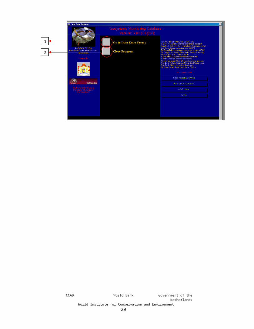
For entering (or “populating”) the data of the field forms into the database, open the database by double clicking on the icon of the file in the storage directory in windows explorer, or by selecting the file from MS Access from “file” on the menu bar. The database will automatically open in the window of the custom formatted Main SwitchboardNavigation button 1 “Go to the Entry Forms” will lead you into the different registration
forms from where you enter the data. Navigation button 2 “Close Program” will exit the programme. It is not necessary to save the
data.Window 1: Main Switchboard
CCAD World Bank Govennment of the NetherlandsWorld Institute for Conservation and Environment
12
1
2

Window 2: Entry Forms Switchboard
The Entry Forms Switchboard gives you navigation buttons to open any of the following data entry forms:Switchboard: A click will return you to the previous page from where you can close
the programme.Full Ecosystem Form: A click opens the form to enter detailed ecosystem data. This form is
primarily used to enter data of a relevé.Fast Ecosystem Form: A click opens the form to enter less detailed ecosystem data and it is
meant for recording of individual species or faunal information.Taxa Data Form: A click opens the form to enter information on individual species. It
is related to any of the previous forms.Aquatic Data Form: A click opens the form to enter detailed information on water data.Soil Data Form: A click opens the form to enter detailed information on soil profiles.Human Activities Form:
A click opens the form to enter information on human activities observed in the field, such as visitation, new agricultural activities, hunting.
Various: A click opens a switch board with forms to enter information on photos taken and on the field observer. It also has a function to aid queries.
To move around in data enter forms, use the tab key to move foreword, or use Shift Tab to move back. It has been designed to automatically lead you through each individual dbfield in a logical order. When you type any character, you will always start at the first left-hand position.
Consistent registration is important for database analysis. Therefore, many dbfields have been designed to allow for only specific data, which can be Arabic numbers (referred to as “ n “) or Roman letters (referred to as “ a “). Each letter stands for a position in the database. In the case of a compulsory number lower, than the required number of positions, start out with a “ 0 “. (e.g. if the required positions are nnn and your observation is 12, then fill out 012).
CCAD World Bank Govennment of the NetherlandsWorld Institute for Conservation and Environment
13

When finished, click “file” and “save” from the menu bar and close the form by clicking the second level cross (not the MS Access application). This will bring you back to the main switchboard. On the main switchboard, click “close application”. This will automatically save your database and close it. You may now close “MS Access”.
You will find that your database file may grow to a considerable size. When you need to send your data, there are two processes you may apply to shrink the size of your file and which may both be used for maximum results. The first is within the database. Go into Tools, open Database Utilities and press Compact Database. There is no need to safe after this operation. Then you compress your file in WINZIP.
CCAD World Bank Govennment of the NetherlandsWorld Institute for Conservation and Environment
14
4. RELEVÉ PROCEDURES
4.1. INTRODUCTION
There is a variety of methods to describe ecosystems (Vreugdenhil et al. 2003). In the following paragraphs, we will briefly review some of the fundamentals of some principles and give advantages and disadvantages. All these methods have some advantages over others, and the database has been designed to function for all of them. The most important thing to remember is to properly record the method used and to work in a consistent, disciplined and orderly manner, with the same data being collected in the same way in all relevés in the study. At the end of the chapter, some criteria are given for the method to be used.
Prepare your fieldwork well. Always prepare customised field forms, with your name, your organisation, your country and any other dbfield already present on your paper field forms. Eliminate dbfields that you will not be using in your study. This gives you more space for making notes. We recommend to always going out in the field with a minimum of two persons. The first reason is for safety. The other reason is transfer of knowledge. If one of the two (or more) scientists is a senior scientist and the other(s) junior(s), then there is a significant benefit of transfer of knowledge. Sending two experienced scientists as one team is not efficient, as the little time gained by working faster on the plot is usually much smaller than the time spent in travel to get to the site, and which could have been used in sampling more areas if the two senior scientists would work separately.
4.2. FUNDING CONSIDERATIONSMany scientists share a notion that science should not be influenced by finances, and we share those feelings. However, the sad world of reality has taught us, that both finances and available professional time are always much more limited than seems to be right. Fieldwork is expensive. For ecosystem maps, at least fifty percent of the funding is required for fieldwork, preferably more! Fieldwork involves transportation12 by four-wheel-drive vehicle, motorised canoes and small planes of helicopters. In addition to transportation, staff time must be taken into consideration, even if the staff is already on the payroll. Often ignored is the staff time needed for field preparation and post-fieldwork, like laboratory identification of samples and entry of data into the database. As a rule of thumb the ratio between fieldwork : preparatory + elaboration work is 1 : 2. Given, that situation, researchers must try to do the maximum with the available resources, bearing in mind the objectives of their study and the availability of funds and/or professional time.
12 For FWD vehicles and canoes we usually calculate about $100 per day, for small fixed-wing planes $300 per hour and helicopters 50 – 75% more. Helicopters fly slower than planes, which makes their cost per km even more expensive. Aircraft are rarely available on the location of need, and additional distances need to be flown between the airport basis and the field of action. Reconnaissance flight can very well be undertaken by fixed-wing airplanes; helicopters are only needed to sample areas of very difficult access.
CCAD World Bank Govennment of the NetherlandsWorld Institute for Conservation and Environment
15

4.3. SIZE, SHAPE AND LOCATION OF THE SAMPLE AREAThe relevé shapes may be linear, square or round and common sizes range from 0.1 m2 to 500,000 m2. The minimum area can be determined in an ecological community using the “nested plot technique”. Figure 1: Nested plot technique.
One initially selects a small area and records all the species in that area, then the sample area is enlarged to twice the size, then to four eight times the size etc. You will see that after several duplications in size, the increase in the number of species only marginally increases. This phenomenon has been discovered by Arrhenius in 1921 and has been found true by biologists all over
the world for all ecosystems It is known as the species/area relationship (SAR), which has been mathematically modeled in the formula S = cAz, in which S represents the number of species and A the size of the area. The constant c is an empirically determined multiplier that varies among taxa and areas (USA Commission on Life Sciences, 1995).
Figure 2The species/area relationship.
The plot size is used of the smallest area after which the increase of the sample area, adds no or few new species to the overall list. Clearly, it is important that the area being studied is homogenous, with no dramatic and obvious changes in ecosystem structure such as open clearings or streams etc. The plotting of species numbers against sample area size produces a species / area curve. The minimal sample size is the point that the initially steeply increasing curve becomes almost horizontal. Cain (1938) suggests using the point on the curve where an increase in 10 percent of the total sample area yields less than 10 more species. Empirical studies in different ecosystem types have produced more or less reliable values for minimum sample seizes.
CCAD World Bank Govennment of the NetherlandsWorld Institute for Conservation and Environment
16
1 3 524

Table 1: Typical sample sizes for different community types
Community type 13 Required sample size in m2
Tropical Forests (including tree stratum) 1000- 10,000Temperate Forests (including tree stratum) 200- 500Temperate Forests Undergrowth vegetation
50-200
Dry-grassland 50- 100Dwarf–shrub and heath communities 10- 25Fertilised pasture 5-10Moss communities 1-4Lichen communities 0.1-1
Species-area curves calculated for tree species in some very diverse tropical rainforest ecosystems seem to suggest that the curve may only begin to level at 5 ha. (Ashton 1965). However, it is generally agreed that in most tropical rainforest ecosystems tree species diversity tends to level out around the 1 ha mark (Campbell et al 1986), and that the examples of Ashton are rather exceptions than the rule.
Shape also is an important for ecosystem characterisation: Two common 1 ha sample areas, a 100 m x 100 m square and a 10 m x 1000 m rectangle have been found to usually produce somewhat different results, with the longer and thinner sample areas producing higher numbers of species. The problem with long narrow sample areas is that they have very high edge to area ratio, meaning that a large number of subjective decisions need to be made about whether a tree is within or outside of the sample area. A compromise shape is a 20 X 500 m rectangle.
The 1 ha sample area has become something of a standard, in quantitative ecological scientific studies for tropical forest ecosystems (House 1997, Gentry 1988, Campbell et al 1986, Prance et al 1976). The 1 ha sample area however, has one very serious drawback, which is the time needed to set up the plot and collect the data. Even if only specimens of more than 10 cm dbh14
are sampled, a 1 ha plot can still take up to 3 months to complete. This determines that the 1 ha sample size is wholly unsuitable for purposes of monitoring and general ecosystem characterisation, such as applied in ecosystem mapping. It can only be applied in detailed research projects with very specific objectives and financial or professional time allotment.
Smaller sample areas can at least contain the most dominant and therefore representative species, even though they don’t include all the species of a given ecosystem. The 0.1 ha sample has become very popular for comparative purposes, since Gentry (1988) compared data collected from 0.1 ha plots of 87 sites in 25 countries to carry out a comparative study of species diversity in different forest ecosystems. Gentry (1982) devised a very simple 0.1 ha plot, which consists of five 2 X 100 m plots. Each 2 X 100 m plot is made by measuring a 100 m line and then sampling all the individual specimens with more than 2.5 cm dbh that occur within 1 m of the line. To qualify for inclusion in the sample, any specimen must have at least the centre of its stem within 1 m of the central line.
13 Adapted from Muller-Dombois & Ellenberg, 197414 Diameter at breast hight, standardized at 1.4 m.
CCAD World Bank Govennment of the NetherlandsWorld Institute for Conservation and Environment
17

Figure 3: A sample consisting of 5 X 100 m transects following Gentry’s method.
At the end of the line, a new 100 m line is set out from the end of the first plot in any direction within 1800. This continues until all 5 plots have been sampled. This system only requires the staking out of 5 lines and not the much more time consuming setting out of a plot. This kind of analysis can be carried out much more quickly, preferably with a team of two botanists. Still, the method requires several days of fieldwork15. In order to apply this method in the database, one can either enter each leg as a separate sample (preferable, but more work), or enter is as a 500 m line, with details on the shape and orientation in the “Description” field. Duivenvoorden et al. (2001) used 20 X 50 m plots for qualitative and quantitative analysis of the North Western Amazon tropical forests.
As even the 0.1 ha plot in its most simple application still can spread over a number of days, even simpler sample areas have been devised. One way of reducing the time needed to analyse a plant community is not to lie out any plot or relevé, but to use plotless sampling techniques. One way of producing a plotless analysis is to use a line intercept method or a point intercept method, where only the species that cross the line or are intercepted by points a predetermined distance are recorded. While these methods have been useful under certain conditions such as the point intercept method in herbaceous communities, in most cases they would be considered to produce less information than either the quantitative plot or the relevé method.
With fieldwork being as expensive as it is, one needs to be very selective with choosing the sampling site. Therefore, it is recommendable to choose a site within a geographical context, particularly, an existing ecological or ecosystem map – or at least a satellite image. If the sampling is done within the context of the production of an ecosystem map, it should obviously be chosen to corroborate and underpin the characterisation of the recognised polygons. Choosing sites at random may seem statistically the right thing to do. However, ecosystems as characterised in maps, invariably are the result of generalisations, and to statistically characterise the common denominator of a certain polygon class usually requires a considerable number of samples. Experienced field ecologists are always capable to select sites with characteristics that reoccur throughout the polygon. For map-making, usually funding is only available for such selective approach. At least 3 sites are required for each polygon type; preferably more; particularly if the recorded species vary strongly. To avoid edge effects, site selection should be at least 200 m, but preferably further away from the edge of a polygon or a visibly distinct ecosystem.
15 In isolated areas, we recommand to always go into the field in pairs. The first reason is for safety. The other reason is for transfer of knowledge. If one of two scientists is senior while the other is a junior one may enjoy the transfer of experience. Sending two experienced scientists into the field together is not efficient, as the reduction of time worked on a single relevé is disproportionate to the time spent on travelling to the location, spent by both scientists, and which could have been used by sending each scientists to a different sites.
CCAD World Bank Govennment of the NetherlandsWorld Institute for Conservation and Environment
18

4.4. SOME SAMPLING METHODSRelevés for the French-Swiss16 methodA relevé is a standardised ecological sample, with a predetermined shape and size to characterise a vegetation type – and mutatis mutandis, an ecosystem. The principal goal of any relevé is to produce a detailed characterisation of the chosen vegetation type, through the listing of all the species present, the description of vegetation structure including all vegetation strata or layers and the recording of local topographic and soil conditions. Vreugdenhil et al. (2002 and 2003) have argued that vegetation classes under the Braun-Blanquet, UNESCO system, USNVC and LCCS represent entire ecosystems. All methods refered in this document are listed in Vreugdenhil et al. (2003)
As ecosystem characterisation is comparative, it requires considerable repetition to recognise the repetition of patterns, for which efficiency in field sampling is important. Therefore, the size and shape of most relevés are based on the minimum sample area needed to produce a representative sample.
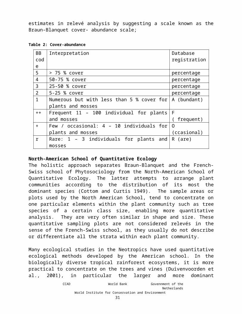
The central figure in the development of relevé methodology was Braun-Blanquet (1928) who believed it possible to arrange plant communities into associations of species based on full floristic composition. A relevé lists all the species within the sample area, and notes community structure with respect to height strata and relative cover. Species are assigned to a particular height stratum. Even though density and dominance are not as important in the relevé methodology as in quantitative ecology, it is important to record relative quantities of each species. Braun-Blanquet made a major contribution to the simplifying of quantity estimates in relevé analysis by suggesting a scale known as the Braun-Blanquet cover- abundance scale;
Table 2: Cover-abundance
BB code
Interpretation Database registration
5 > 75 % cover percentage4 50-75 % cover percentage3 25-50 % cover percentage2 5-25 % cover percentage1 Numerous but with less than 5 % cover for plants and mosses A (bundant)++ Frequent 11 – 100 individual for plants and mosses F ( frequent)+ Few / occasional: 4 – 10 individuals for plants and mosses O (ccasional)r Rare: 1 – 3 individuals for plants and mosses R (are)
North-American School of Quantitative EcologyThe holistic approach separates Braun-Blanquet and the French-Swiss school of Phytosociology from the North-American School of Quantitative Ecology. The latter attempts to arrange plant communities according to the distribution of its most the dominant species (Cottom and Curtis 1949). The sample areas or plots used by the North American School, tend to concentrate on one particular elements within the plant community such as tree species of a certain class size, enabling more quantitative analysis. They are very often similar in shape and size. These quantitative sampling plots are not considered relevés in the sense of the French-Swiss school, as they usually do not describe or differentiate all the strata within each plant community.
16 Or Braun-BlanquetCCAD World Bank Govennment of the Netherlands
World Institute for Conservation and Environment19
Many ecological studies in the Neotropics have used quantitative ecological methods developed by the American school. In the biologically diverse tropical rainforest ecosystems, it is more practical to concentrate on the trees and vines (Duivenvoorden et al., 2001), in particular the larger and more dominant individuals. Usually, a dbh > 10 cm is used to select the dominant individuals for larger sample areas and 2.5 cm for smaller sample areas. The dbh of an individual tree can be used to calculate the basal area, which is a proxy for individual dominance. Romero-Saltos, Valencia & Macía carried out studies to determine distribution/rarity/abundance in the tropical lowlands of Ecuador (Duivenvoorden et al., 2001) using 20 X 50 m plots using woody plants (DBH>2,5 cm), lianas (DBH>2,5 cm) and trees (DBH>10 cm).
Species Importance EvaluationOther measurements of dominance include measuring height and canopy area; those are more difficult to assess in dense forest ecosystems. If the position of each individual within the sample area is measured it can be used as a means of calculating the frequency of any given species, based on the presence or absence of a particular species within a number of sub-units of the sample area, for example dividing 1 ha into 25, 40 m2 sub-units. Cottam and Curtis (1956) were the first ecologists to try to combine these common measurements of each species (density, dominance and frequency) into a single comparative expression, which they called the “importance value”. This value defines which of the species present contribute most to the character and structure of a given ecosystem. The importance value is calculated by the sum of relative density (number of individual of a species/total individuals x 100) relative dominance (total basal area of a species/total basal area x 100) and relative frequency (number of sampling units in which species occur/total number of sampling units x 100). The results a small number of species having high importance values of above 30, while the majority of the species have importance values closer to 1.
Point-Centred-Quarter methodOther plotless techniques include a variety of methodologies based on relative distance between individuals. One of the most reliable ones is the Point-Centred-Quarter method (Cottom and Curtis 1956), which involves recording just four individuals around each sampling point, each individual being the closest to the central point in its quarter of an imaginary circle centred around the sampling point. Any number of sampling points can be taken at a predetermined distance along a sampling line. The Point-Centred-Quarter method does not really characterise the ecosystem, but it may be very useful in determining the point at which ecosystems change along environmental gradients such as altitude changes on mountain transects.
Bitterlich’s Variable Radius MethodA plotless sampling technique that has gained some popularity and had an important impact on ecological studies is the Bitterlich’s Variable Radius Method. In this method, trees are counted in a circle from a central sampling point with an instrument known as a sampling gauge. Only trees that appear larger than the diameter of viewing plate or aperture are included. The plot has no fixed radius as it depends on the size of the trees being sampled (smaller tress producing smaller plots). When trees are counted in this manner with an angle gauge, their number is proportional to their stem basal area. An angle gauge with an arm17 of 50 cm and a cross piece or viewing aperture of 1 cm, produces a ratio of 1:50 which makes the total tree count the same as the total basal area in m/2 per hectare. The basal area is no more than a form of cover or dominance (not 17 You can make your own device with a cord with a not at precisely 50 cm from the device, which you hold between your teeth when counting.
CCAD World Bank Govennment of the NetherlandsWorld Institute for Conservation and Environment
20

density) and therefore is very useful as means of calculating tree species cover in diverse forest ecosystems, where, shrub and herb cover are calculated according to the relevé methodology. The percentage cover of each tree species in the tree strata is no more than the basal area of each species divided by the total basal area times by 100. Figure 5 gives a simple but effective design for making a basal area measurement device.
Figure 4: Design of a basal area measurement device. Cut an sheet metal disc of approx. 60 mm diameter. Cut 3 notches around disc at 7mm, 10mm & 14mm wide. Widths must be as accurate as
possible. Push a piece of string through the centre hole. Knot both ends of the string so the knots
are precisely 500mm apart (ensuring knots won't pull through disc) & trim excess. The Basal Area Factor for the 7mm notch is 0.5, for the 10mm notch is 1.0 & for the
14mm notch is 2.0.
The database can receive ecological data from each one of these sampling methods. Even though it was not considered advisable to lay down a single methodology, it was deemed necessary to make a number of recommendations on how the fieldwork sampling should take place. One of the most important decisions taken was that it was desirable to use the relevé approach, in that it is an holistic and descriptive approach that would efficiently produce the information needed to define plant communities according to the UNESCO classification system. In particular the importance in the relevé methodology of precise geographic positioning, and detailed descriptions of local topography and soil structure were deemed relevant as well as the inclusion of all of the species found in the relevé, and detailed descriptions of the vegetation structure including identification of all strata present. Another important aspect of the relevé methodology is that it allows for subjective judgments about homogeneity and representativity during the process of site selection for the relevé (something to be avoided in quantitative ecology). The site for any relevé must be judged to be homogenous and representative of the community to be studied. It should avoid obvious breaks in cover due to tree falls or streams and it should also avoid human intervention and close proximity to ecosystem edges.
The Land Cover Classification System, LCCSThe LCCS generates a detailed class and code in which the generated name shows all characteristics of the ecosystem in a highly organised fashion. The modifiers in its hierarchy are very similar to the ones in the UNESCO and USNVC systems, but given its design more consistently executed. Classes classified with the LCCS – both names and codes - can be stored in the database.
CCAD World Bank Govennment of the NetherlandsWorld Institute for Conservation and Environment
21

Relevés for general ecosystem characterisationAvailable finances and professional time are primary determining criteria for selecting a sampling method. For mapping studies and general ecosystem characterisation, it will usually not be possible to spend more than a 2 to 3 hours per relevé; this will restrict the number of relevés to 2 or 3 per field day. During such a time-span, Braun-Blanquet relevés can only be carried out for ecosystems requiring small sampling areas and low biodiversity, such as temperate and high elevation meadows (including paramos) and forests. For the Map of the Ecosystems of Central America, a 25 m radial plot was chosen as the recommended relevé size and shape. The reason for choosing this plot was that it is quick to set up, and that it is broadly compatible with the Bitterlich’s Variable Radius method for forest trunk-cover calculation. In forest ecosystems, the Bitterlich methodology produces a radius of 20 - 30 m. The 25 m radial plot gives a total plot size of around 2000 m1, twice the size of the 0.1 ha plots frequently sampled for biodiversity analysis in tropical ecosystems. The plot is set-up from a central point where a 25 m line is measured, from the central point and all the trees above 10 cm dbh within the 25 radius are recorded. The observer then turns a full 360 degrees identifying each individual with 25 m of the observation point. It is normal practice to place temporary stakes at 25 m from the central point at the four cardinal points to help in the definition of the relevé; intermediate stakes can be placed. More information on this method can be downloaded from:Further documentation on this method can be downloaded from: http://www.birdlist.org/nature_management/monitoring/monitoring.htm .
For individuals found on the edge of a relevé, if in doubt, the individual should be included, in particular if that species has not been recorded in the relevé. An experienced observer should be able to identify the majority of tree species above 10 cm dbh. Of all species whose identity is in doubt, voucher specimens must be taken for later taxonomic determination - even if sterile. The plot should produce density data (number of individuals in the plot) for all the identified tree species, unidentified tree species should be recorded as indent 1, indent 2 etc. and their densities also recorded on the field form. Sample should be identified in the laboratory and registered after identification.
Some researchers have a preference to work in rectangular plots, which is very well possible. The selection of the size and shape of a relevé is obviously important, but most importantly, is that the sampling be correctly recorded. The database allows the entry for both rectangular (most commonly used) and circular plots. For rectangular relevés, geographical orientation needs to be recorded and for all plots the sloping needs to be recorded in degrees as well as slope orientation. When rectangular plots are preferred it is recommended to use the characteristic minimum-area size proposed in Table 2 or for (sub-)tropical forests 20 X 50 m relevés (Duivenvoorden et al. 2001). In (sub-)tropical forests only trees should be recorded that are wider18 than 10 cm dbh.
Permanent plotsFor monitoring purposes of ecological developments, it is recommended to use permanent rectangular plots as suggested in the previous paragraph. As you intend to resample this plot over a long period, it is important to avoid impact from trampling and sampling. Mark your plot with metal or concrete markers. You must work very carefully and not sample plants from the plot that occur less than frequently. Samples of occasional and rare specimens must be taken from the vicinity outside the plot. It is recommended to obtain fauna data from the same area, but if
18 Only measure the doubtful specimens.CCAD World Bank Govennment of the Netherlands
World Institute for Conservation and Environment22

sampling requires physical presence on the ground (e.g. for using mist nets), the sampling must NEVER be done on the same spot, but next to the botanical relevé, to avoid additional trampling. If you plan to carry out both floristic and fauna monitoring, make sure to select a homogenous site that is large enough to perform various sampling exercises next to each other.
General recordsGeophysical data relevant to the characterisation must be collected within the recommended survey time of several hours. The details of each characteristic are given for each field form in the following chapters. Weather data are NOT needed for ecosystem characterisation19. The collection of detailed soil data is very time consuming, both in the field and laboratory verification, while they appear to be less deterministic for species composition and ecosystem characterisation than some of the other parameters, such as drainage, elevation and physiognomic structure, particularly in natural (climax) situations. Therefore, they only receive very brief review for purposes of general ecosystem characterisation and monitoring. Form I, Full ecosystem data, allows the entry of rapid superficial field observations. If some detailed study does require full soil profiles, the data must be recorded through Form V, Soil data, which has been designed on Tropenbos 4 (Touber et al. 198920), which allows very detailed descriptions of an un-limited number of soil horizons.
In Field Form I, Full ecosystem data, you should mention if you used the UNESCO, the USNVC, the FAO LCCS, the Braun-Blanquet or another method. This is important for the ecosystem classification, although the field data may serve to support the studies of any of the other systems.
19 Weather data are primarily collected to support observations on fauna and visitor use.20 Touber, L. Smaling, E.M.A. Andriesse, W. and Hakkeling, R.T.A., Inventory and evaluation of tropical forest land: guidelines for a common methodology, Tropenbos technical series. The Tropenbos Foundation, Ede, the Netherlands, 1989.
CCAD World Bank Govennment of the NetherlandsWorld Institute for Conservation and Environment
23

5. FORM I: FULL ECOSYSTEM DATA
5.1. GENERALThis form still provides a wide range of ecological parameters that can be filled out. Probably, not all data are relevant for you. You, as a user must decide which ecosystem data you consider useful to fill out. You can design a shorter printable field form by eliminating those parameters from the printable fieldform that you will not be using. Freeing up space may require some formatting work. You can enter data beforehand that always remain the same, like your initials and the institution for which you work.
You will find small buttons, which upon a click unfolds a “pull down” menu from which you can select the required datum by pointing.
The Full Ecosystem Data Form has been organized to collect data in four major groups whose data will be described in detail:
1. Tracking data2. Data on Human influence3. Physical data4. Biotic data
Window 3: Form I: Full Ecosystem Data Form
CCAD World Bank Govennment of the NetherlandsWorld Institute for Conservation and Environment
24

In the black header of the form you will find a navigation buttons that take you to other data forms as well as a button for calculation of GPS formats:Calculate : A dialogue box opens upon click. It will inform you that you are about to
convert the coordinates from degrees, minutes and seconds as entered by the user will be converted into decimal degrees, which can be read by the majority of GIS applications. Depending on the number of data that need to be converted and the speed of your computer, this may take considerably time and it may stop all other functions of you computer during application. You are advised to only do this at the end of your day when you no longer need to use your computer.
Water Data: A click opens the Aquatic Data Form to enter detailed information on water conditions.
Soil Data: A click opens the Soil Data Form to enter detailed information on soil profiles.Switchboard: A click will return you to the previous page from where you can close the
programme.Taxa: A click opens the Taxa Data Form to enter information on individual species.
It is related to any of the previous forms.Weather data:
A click opens the form to enter the Weather Data Form. The weather data form can only be opened with this button. This has been designed on purpose to avoid entering data twice.
5.2. TRACKING DATATracking data register time and place coordinates to site descriptions and allow for identification (and therefore future visits) of each individual observation. Tracking data are a fundamental prerequisite for fieldwork; without this information, the collected data cannot be related to a location and moment in time and consequently, they lose much of their value for purposes of mapping, monitoring and statistical analysis.
The Site code is designed to make the data of a given site and given time unique. By giving the first 6 fields for the date, than 4 letters for the location, followed by 2 digits for the sequence, it may provide an almost unrestricted number of entries for every date of the year. In theory this may provide some difficulties when combining data from other users, but any database manager can solve such problem.
Furthermore the tracking data provide information about place (latitude, longitude or UTM), date and time. We have complemented this with info on the plot, country, geographical names, etc. This information is combined in a small but essential table in the database: “TRACKING”. For the entering individual species, water samples or soil surveys (from Forms III, IV and V respectively) it is also possible to only enter those data by filling out the “bare” Tracking Data exclusively (which lists no ecological data at all). In Forms III, IV and V you will find a button that leads you to the “bare” or minimal Tracking Data Form IX. If you choose to forego entering ecological data, you must use Form IX and you may no longer use forms I or II in combination with those data. That is the shortest way of entering data.
Nota bene: If you wish to also enter ecosystem data, you must use either form I or II and not go to form IX. Here again, you will have to choose for either one. You cannot use both! In the database, we designed Forms I and II to automatically enter the sitecode for you. If you first use the Tracking data Form (IX), you will be forced to enter a new code and you cannot combine
CCAD World Bank Govennment of the NetherlandsWorld Institute for Conservation and Environment
25

your data with the ecosystem data as you intended. To avoid this problem from occurring, we have created a detour for reaching Form IX. You can only reach it through Forms IV or V.
If you need to design a new data table to fit your specific needs, you would need to link such table to the TRACKING table, so that you can relate your information to other data.
Site Code*: Tracking items include an observer-defined site code, which is a unique identifier based on the date defined by the two last digits of the year, the month and the day, followed by a four-letter code chosen for the site and two digits for sequential observation on the observation date: yy-mm-dd-aaaa-nn. This code is compulsory for all sub-tables.
Observer*:3-character code to define the observer. The user can permanently enter his/her code in the MSWord file and as the default in the database. The first time you use this database you need to fill out Form X: Observer data.
Organization Code:Up to 8-character code for the organization responsible for the investigation and the administration of the database. The user can permanently fill out his/her organization in the MSWord file and as the default in the database. Individual observers under contract by a national governmental institution or an international agency cooperating with that institution, fill out the governmental institution and not the financing agency (e.g. MARN and not World Bank). You may fill out these data as default in your database forms and MSWord forms.
State/Department/Province:Fill out the State/Department/Province. This db-field does not appear on the field form.
Municipality/township/county:Fill out the township/county/municipality or equivalent.
Country*:Three-digit code for country consisting of the telephone country code (e.g.: 505, Nicaragua, 001, USA, 057, Colombia). If your country has two digits, you must first enter a 0. It is recommended that in your MS Word file of the field form, you fill out your country number, so that you don’t need to fill it out each time. In the database, the observer can set his/her country of operation as the default.
Date*:The field data is the year, month and day of the observation, recorded as, where y = year, m=month, d=day of month: yyyy-mm-dd
LT:Local Time. Usually only needed for fauna observations. For faunal counts with plural observations you may enter the beginning time of your observations and enter a specific time and position in the Taxa form for each observation. Specify you method in “Directions”.
Latitude (W) and Longitude (N)*:CCAD World Bank Govennment of the Netherlands
World Institute for Conservation and Environment26

Register the latitude and longitude in degrees (D)21, minutes (M) and seconds. Only the W position starts out with the global hemispheric quadrant of the site (NE = 1, NW = 2, SE = 4, SW = 3; always 1 for Central America). It is necessary to start out with a zero (0) after the quadrant, when the degree value is less than three digits. This is always the case for Central America.
Attention: several GIS systems work in degrees and decimals of degrees (e.g.: 87.595493). The database has a gray button with red text to automatically calculate all the entered degrees, minutes and seconds into degrees with decimals of degrees. This is a large calculation and depending on the number of data and the speed of your processor, this operation may take a while. We recommend not carrying out the operation until you need to enter your data into a GIS system.
UTM zone, UTM X and UTM Y:Alternatively you can register UTM zone, UTM X and UTM Y. This is an added feature for your convenience and not compulsory. It is preferable to use latitude and longitude. It was not possible to include coordinates in UTM for forms (VI and VII).
Protected Area:Name of the protected area. If protected area type appears in the “administration” list, don’t include the category in the name and write as one word in uppercase. (e.g. register Parque Nacional Braulio Carillo as BRAULIOCARILLO). Maximum 55 characters.
Geographic range:Name of geographic range, like Cordillera de Nombre de Dios (one word in uppercase: NOMBREDEDIOS). Maximum 55 characters.
Dimensions of the plot in Length & Width & Orientation, or in Radius:Circular plots are defined by their radius. As a standard for observations for the ecosystems map, circular plots have been used with a radius of 25 m. However, for the shores of aquatic ecosystems, circular plots are often not practical. Extended shore lines (up to 1000 m) may be required to characterize the ecosystem.
Attention: Some observers like to chose an elongated rectangular plot perpendicular to a gradient to include the different elements of the gradually changing ecological conditions. This way they capture several ecosystems in one characterization. As this database is designed to characterize only one ecosystem at the time, the selection of plots perpendicular to the gradient should be avoided, and instead plots should be chosen parallel to the gradient, including only one ecological condition at the time. Several plots will be needed to characterize a gradient. Alternatively, one may make a relevé of only the predominant aspect of the gradient.
Existing permanent plots or specific monitoring plots, may already have or require a rectangular shape. Rectangular plots are registered by their length, width and orientation in degrees from true north. All plots are defined by their geometric center.
Point observations can be registered as a 0 (zero) radius.
21 For instructions on how to obtain this reading, please read the manual of your GPS unit.CCAD World Bank Govennment of the Netherlands
World Institute for Conservation and Environment27

Topographic map nr.:Fill out the topographic map number if known.
Directions:Directions for finding the plot are to be provided by the observer. Also make note about methodology used if needed. 255 characters. Please write briefly.
5.3. HUMAN INFLUENCEType of land administration:
The type of land administration is paramount for the conservation of the natural condition of natural ecosystems. In this database 11 major categories are recognized. In principle these categories cover most administrative categories, although local names may sometimes vary. In such case the nearest match should be chosen, or if significantly different, mention it in the “Description of physical elements” field.
1 Man and Biosphere Reserve 2 World Heritage Site 3 ecological or nature reserve 4 national park 5 national forest 6 fauna reserve 7 recreation area 8 communal land 9 private reserve10 private land11 non-defined national land12 other
PerturbationBecause the effects of human disturbance are so important to biological conservation and understanding land use and cover change processes, it is important to estimate the degree of human intervention a site has been subject to. Distinct perturbation classes have been set up for terrestrial and aquatic ecosystems, as defined in the following paragraphs. In seasonally flooded areas, the differentiation between a land ecosystem and an aquatic ecosystem may be arbitrary depending on the season. Choose one or the other, depending on whether – in your judgement - aquatic or terrestrial conditions prevail.
Originally three degrees22 of intervention were distinguished. It was found however that it was difficult to distinguish three levels from satellite images. Therefore only 2 classes of distrubance have been mapped on the Central American Ecosystems Map, in which disturbance classes 2 and 3 as presented in the following paragraphs have been combined. It is however still considered useful to distinguish 3 classes for site analysis. It is however still considered useful to distinguish 3 disturbance classes for site analysis, as it provides very detailed and specific information of a specific site. It is recommended to continue combining disturbance classes 2 and 3 in a mapping disturbance class 2 for mapping purposes, while distinguishing 3 for site analysis.
22 The class “ natural” is not part of these three degrees and it is not registered in a map, since classes are considered natural, unless stated otherwise. It must be registered however in the database.
CCAD World Bank Govennment of the NetherlandsWorld Institute for Conservation and Environment
28

Perturbation land ecosystem:The following classes are recognized:0 Natural No traces human intervention apparent for at least several
decades.1 Disturbance class 1: Woody structure largely intact; Herbaceous layer lightly
grazed and/or cropped, possibly occasionally burnt; Savannas seasonally burnt with grazing practically absent or absent;
2 Disturbance class 2: Woody structure largely intact with occasionally logged trees Herbaceous layer moderately grazed and/or cropped, possibly occasionally burnt; Savannas seasonally burnt with moderate grazing;
3 Disturbance class 3: Woody structure distinctly logged and forest structure severely thinned but maintaining forest characteristics, grazing moderate or absent, possibly burnt; Savannas seasonally burnt and intensively grazed;
4 Agricultural systems5 Urban environment6 Other
In many cases the magnitude of human intervention is evident, while in others it is less conspicuous. The classification is bound to be subjective, but it still gives an indication of the degree of human influence. E.g. much of the coastal plains of the Mosquitia area and the coastal plains of Belize are burnt every few years or annually. This results in various degrees of suppression of forest growth. However, with no grazing present, the vegetation has a strong natural appearance. In such case class 1 could be suggested, while in areas with moderate grazing, class 2 seems more appropriate. Many spontaneously seeded Caribbean Pine stands in Belize, and the Mosquitia are managed as production forests through thinning and selective logging. Still these forests maintain well-developed shrub and vegetation covers and maintain distinct natural characteristics. Under such conditions class 3 would be appropriate as opposed to the alternative of forest plantation.
Forest plantations, agroforestry, permanent intensive pastures, as well as all industrial plantations and production crop systems all fall under agricultural systems.
CCAD World Bank Govennment of the NetherlandsWorld Institute for Conservation and Environment
29

Perturbation aquatic ecosystem:As in terrestrial ecosystems, there are three classes of disturbance for site analysis:0 Natural1 Modified natural class 1: Natural aquatic formation surrounded by moderately intensive
agricultural practices; shores largely in tact; no eutrofication; uninterrupted connection with the sea. Small-scale fisheries.
2 Modified natural class 2: Natural aquatic formation surrounded by intensive agricultural systems, moderately eutroficated and /or with moderately grazed shore communities; altered water bodies (dredged coastal canals along Atlantic coast of Costa Rica) in swampy environments with natural aquatic shore communities and moderate to good water quality.
3 Modified natural class 3: Severely eutrophicated (green, non-transparent) surface water with largely reclaimed shores (urban construction; agricultural use) or man-made water systems with important natural characteristics like stabile shore communities, good water quality (Panama Canal).
4 Man-made water system5 Aquaculture6 Other
Usually, water reservoirs fall under the category of man-made water systems, as their water tables severely fluctuate in short periods of time, which does not allow for the development of stable shore communities.
Perturbation cause:In the case of disturbance, try to assess the main cause of intervention. If necessary, elaborate in the Description of physical elements field. Don’t fill out for undisturbed ecosystem.
1 fire 2 wind 3 insects 4 disease 5 logging 6 grazing 7 drought 8 flooding 9 recreation pressure10 pollution11 other
CCAD World Bank Govennment of the NetherlandsWorld Institute for Conservation and Environment
30
5.4. PHYSICAL DATALand formation:
A choice of 10 major categories is listed: 1 mountain 2 hill 3 footridge/slope 4 plateau 5 upland 6 piedmont plain 7 valley 8 coastal plain 9 flood plain10 dune 11 lava flow12 other
If a significantly different category applies, enter other and specify in the Description of physical elements field.
Position on slope:Relative position of a plot in hilly terrain. Don’t fill out in the case of plains or flat upland plateaus. If in a valley, fill out “base”.
1 top2 upper slope3 mid slope4 lower slope5 base
Elevation Source:The source of the elevation can be indicated as either: 1) altimeter, 2) map or 3) GPS.
Elevation:Elevation is defined as the average elevation of the site polygon in meters above sea level, based on topographic maps, global positioning system (GPS) and altimeter readings for field plots.
Slope Angle:Slope angle is the inclination of the slope in degrees determined by estimation, hand level or tape measurement. For flat areas; fill out “0”.
Orientation:Slope orientation or aspect is the direction of the slope of the site, recorded in degree units from north based on compass or GPS readings. The range is therefore 0-360, however the value of 399 is used for strongly variable slopes. Don’t fill out if slope angle is 0.
Soil geology:For general ecosystem mapping only superficial soil data are collected. No soil drillings are to be performed or descriptions of soil profiles required. Soil data are only registered on the basis of surface examination of exposed mineral soil. Profound soil records can be registered
CCAD World Bank Govennment of the NetherlandsWorld Institute for Conservation and Environment
31

in the SOIL form. Five choices of geological origin are given. If origin is not known, don’t fill out the db-field.
1 igneous2 plutonic3 metamorphic4 sedimentary5 non- consolidated6 other
Soil type:Five choices of soil types are given. If soil type is not known, don’t fill out the dbfield.
1 clay2 lime3 sand4 clayey-sandy5 clayey-limy6 organic soil7 peat8 other
Soil colour:Seven choices of soil colours are listed.
1 white2 grey3 brown4 black5 ochre6 red7 other
CCAD World Bank Govennment of the NetherlandsWorld Institute for Conservation and Environment
32

Moisture regime soil:The moisture regime of the site is intended to be used to describe the prevailing and seasonal water balance of plots. It does not refer to the soil condition at the moment as that is a condition that varies constantly. Take into consideration prevailing climatic conditions, drainage, absorption capacity of the soil, etc. to make your assessment. Assess the moisture characteristics for both the wet and the dry season in the relevant columns of your form. Please note that a land ecosystem may have saline conditions. This is often indicated by mangrove23 or other salt-tolerant plants. Desiccated: Extremely dry conditions resulting from desert to semi-desert
climatic circumstances. Rare in Central America.Dry: Seasonally dry conditions. Usually reflected by vegetation as
deciduous phenologyMoist: Moisture apparent throughout most of the year due to abundant
rainfall under good drainage conditions; or good water conservation during dry periods, due to moderate to poor drainage.
Wet: Site is extremely humid throughout most of the year due to abundant rainfall and/or moderate to poor drainage.
Saturated: Poorly drained soils that are saturated during a good part of the wet or rainy season.
Drainage:This field allows for further characterization of the moisture regime by defining drainage and inundation levels and also aspects of human interference.well drained: Sloping (hilly to mountainous) terrain that facilitates
continuously rapid surface drainage; if in flat terrain, soils are extremely porous.
moderately drained: Very mildly undulating terrain with regular to mildly porous structure which during the wet prevents waterlogging most of the time; no significant periodical flooding.
poorly drained: Flat terrain with dense soil structure which leads to waterlogging during the wet season but no significant flooding.
periodically inundated: Terrain covered by water for more than 50% of the surface. It includes, riverine and marine flood plains and tidal zones.
permanently inundated: Terrain covered by water for more than 50% of the surface most of the time. It may include, marshes and swamps and tidal zones. For tidal zones use 400 in duration of inundation.
Irrigated: Irrigated system.Impounded: Water locked in by man-made conditions, like rice fields, water
trapped behind a road, shrimp farms, etc.
23 Occasionally mangrove may grow under apparent fresh water conditions. In such specific cases, make sure to mark “fresh water” under the “water characteristics”.
CCAD World Bank Govennment of the NetherlandsWorld Institute for Conservation and Environment
33

Aquatic formation:Eleven classes of aquatic systems have been chosen. If a different system is required, fill out “other”, and specify in “Comments regarding physical elements”.
1 marine system 2 estuary 3 river 4 coastal lake 5 coastal canal 6 inland lake 7 volcanic lake 8 karstic lake 9 reservoir10 dredged system11 swamp / marsh12 other
Water characteristicsThe characteristics refer to some ecologically important differentiating physical categories:
1 fresh 2 brackish3 saline4 volcanic dissolvents5 thermal6 other
Further details can be specified in the aquatic data monitoring form, but that is not required for general ecosystem mapping purposes.
Composition of the water bottom:The following classes of water bottom are listed.
1 soft sediments 2 sand 3 rock debris 4 bedrock 5 coral 6 other
Depth source:Refers to the information source, which can be a map, an estimate or an instrumental measurement.
Depth:Maximum depth of plot in meters. In Description of physical elements more details can be given about maximum depths of water body.
Submerged shore slope:Estimate the submerged shore slope angle in degrees.
Flow velocity:
CCAD World Bank Govennment of the NetherlandsWorld Institute for Conservation and Environment
34

Estimate the flow velocity in kilometers per hour. This can be measured by throwing a leaf in the current and estimate the distance traveled during one minute to calculate velocity. For visibly but very slow flowing currents, fill out 01 if estimate cannot be more precise. For stagnant waters one must fill out 0, which is very different from a blanc entry.
Duration of inundation:Estimate the duration of inundation in days per year during a typical year. In the case of tidal inundations, which are a form of periodical inundation, use 400, which will be interpreted as daily tidal inundation. Duration of tidal flooding period of the site itself may be added in description. Be aware that the flooding period of each location varies greatly depending on the elevation and tidal characteristics of an estuary.
Inundation season:Indicate the inundation season in months (mm / mm) during a typical year.
Estimated normal fluctuations:Estimate fluctuations in the water table expressed in meters during a typical year. This may need further elaboration in the “Description of physical elements”.
Description of physical elements:This 255 letters field allows for any description. Please work in telegram style!
CCAD World Bank Govennment of the NetherlandsWorld Institute for Conservation and Environment
35

5.5. DATA ON THE VEGETATIONThe biotic data to be collected for ecosystem mapping are primarily based on the characteristics of the parts of the vegetation that grow into the air or the atmospheric part of the biosphere, and which will be referred to as “atmospheric” vegetation elements. For aquatic ecosystems without ”atmospheric” vegetation, other considerations can be taken into account – depending on the level of detail: floating and submerged vegetations, specific life forms (corals), geology and geography.
“Atmospheric” 24 Vegetation elements
All StrataWhile recognizing that specific layers or strata are often a very arbitrary characteristic in a vegetation (Oldeman, 1990) and in many cases statistically absent, it is still helpful to analyze the vegetation by several distinctions of heights. Consistent with the UNESCO classification system, the database distinguishes three strata: Tree Stratum (> 5m); the Shrub Stratum (between 1 and 5 m, default in database) and the Ground Stratum (<1,5 m) (Mueller-Dombois, 1973). The term “Ground” Stratum has been used instead of “Herbaceous” stratum as in this stratum also the ground cover of non-living elements is registered. Please note that the ground stratum is height defined and may include woody plants as well as non-vascular plants, while the shrub stratum may include tall (> 1,5 m) herbaceous elements. The separations are arbitrary, and the surveyor may sometimes wish to deviate from the defaults, reason for which the heights of each stratum may be specified. No height filled out for Shrub or Ground stratum means standard heights.
Ecosystem class: The UNESCO physiognomic-structural vegetation and classification system is the principal classification used for the ecosystem-mapping component where at least some vegetation elements are present (including submerged vegetation). The observer may refer to other classes in the “Comments on the vegetation”. It is recognized that the UNESCO system needs some modification. Several institutions have worked at an updating (ITC, TNC, FAO and others). The FAO LCCS is still under development and is a system that works particularly well with GIS systems. This system is likely to become the word’s standard system (Vreugdenhil 2003).
For aquatic ecosystems with atmospheric phenology, the UNESCO classification prevails. In absence of atmospheric vegetation components, you may use class VIII, Open water or one of its subdivisions.
The database can be used for other classification systems as well, in which case you can enter a different classification category in this db-field.
Classification systemThis field determines which classification system is used. (UNESCO, LCCS, USNVC, Braun-Blanquet). UNESCO is default.
24 Atmospheric vegetation elements are those parts of the vegetation above the surface of land or water. These are the that the elements that grow into the atmosphere and can readily be observed in the field and from remotely sensed data sources.
CCAD World Bank Govennment of the NetherlandsWorld Institute for Conservation and Environment
36

DistributionThis field refers to the distribution patterns within the vegetation at large (not within the plot) of a polygon. Random uniform means that the dominant life forms are distributed at random, but their distribution is rather even, and from a distance – as seen from the air, the vegetation has a uniform appearance. In natural vegetations the most commonly found distribution will be random uniform for vegetations with a finer texture. Random clumped refers to very coarse texture vegetations, such as savannas with clusters of closed woodlets. Ordered distribution refers to plantations in which the trees are planted a specific pattern. Ordered clumped are typical for commercial plantations with various fields each with identical age classes and/or species. Linear distribution will typically be associated with ecotones, like shores, beaches and gallery forests. Linear does not refer to the linear rows in a plantation, which instead would be ordered uniform.
1 random uniform2 ordered uniform3 random clumped4 ordered clumped5 linear
Texture:The differentiation of development of the vegetation within the landscape is important for determining the nature of disturbance, the ecosystem dynamics and stratum/canopy geometry in its horizontal composition. The texture defines the structure of the vegetation in its horizontal dimension as it is seen from above. The texture may have various degrees of spatial variation or maze, which can particularly be observed on slopes, from elevations, from the air, aerial photographs or images. This variety may not always be visible at the site. The degree of variety varies from homogenous to very coarse:1 homogenous: Vegetation with closely stuck trees, shrubs of herbs that gives an
impression of a homogeneous vegetation blanket. (e.g. steppe, meadow, same age-class of single-species forest);
2 fine Closed tree or shrub cover with distinct variation in heights and dimensions of crowns, but without abundance of openings (chablis). Usually well developed tropical ombrophilous forest;
3 medium Broken tree or shrub canopy with distinct openings in the dominant cover or clumps of distinct species of up to 3 times the height of the tallest life form; Visible on aerial photographs;
4 coarse Broken tree or shrub canopy with distinct openings in the dominant cover or clumps of distinct species of clearly more than 3 times the height of the tallest life form but less than 100 m; Visible on LANDSAT images as a coarse grain.
5 very coarse Tree or shrub cover with varying structure of more than 100 meters and distinguishable on Landsat images as fine patterns within polygons. Usually mosaics of open forest or shrubland with meadows, swamps or savannas.
Please note that texture and distribution are located in the column of the Tree stratum, but they refer to the overall texture and distribution of the vegetation.
CCAD World Bank Govennment of the NetherlandsWorld Institute for Conservation and Environment
37

Indicator life forms:Some life forms may indicate certain ecological conditions. As absence of such indicators may have indicator value as well, please register 0 if absent.
Some arboreal life forms may have indicator value: Abundance of arboreal palms is often indicative of poor drainage. Tree ferns are more common in tropical forests at higher elevations and their presence may indicate the distinction between low land and (sub-) montane tropical ecosystems. Acaule (truncless; may occur in Shrub and Herbaceous strata) palms may indicate disturbance. The following life forms are recorded in percentage:
Arboreal Palms Acaule Palms Tree Ferns
Some life forms are usually dependent on trees or shrubs, but not always. The coverage of such tree- or shrub-supported plants is often hard to assess; therefore their presence is registered in the abundance classes: (0) absent, (1) rare, (2) common, (3) abundant. Tree-bound epiphytes may be split in three categories, each indicating different ecological conditions: drapery, sessile and climbing associations. Many Vines and sessile epiphytes are heliophylous and their abundance may indicate disturbances from both anthropogenic (felling or burning) and natural (hurricane) origin. Tree- or shrub-supported life forms:
Vines Drapery Epiphytes Sessile Epiphytes Climbing epiphytes
CCAD World Bank Govennment of the NetherlandsWorld Institute for Conservation and Environment
38
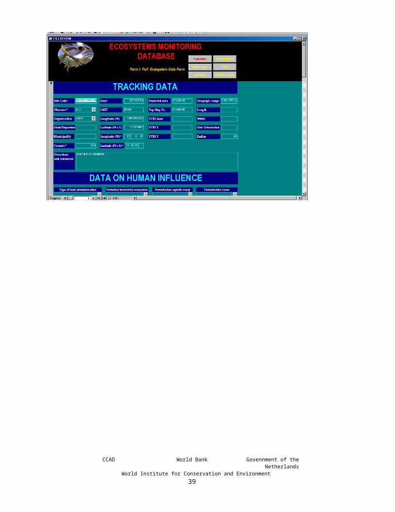
Ecosystem dynamicsThe dynamics of the community is recorded in classes of increasing dynamics. It is often difficult to make a good estimate of the real age of an ecosystem and possibly it makes more sense to register its dynamics. Particularly the difference between Pristine (never deforested) and Ancient or Mature (deforested in a distant past but since then recovered to a new climax forest) is difficult to assess in Maya territory, as well as in hurricane prone and fire swept territories of the Caribbean lowlands. In assessing the dynamics, there is no judgement whether disturbance is of natural or human origin. Between brackets, indications of period of regeneration since last incident of destruction. Destruction may occur as a constant factor, such as seasonal burning, inundation, flushfloods, etc. Under such circumstances the dynamics are “stable” meaning that the ecosystem will stay very much the same, but the ecosystem dynamics are high resulting in a status quo under those conditions.1 pristine Never disturbed climax vegetation;2 mature Disturbed in (pre) historic past but regenerated to
climax (> 200 years; e.g. documented former Maya territory);
3 old secondary growth Disturbed in historic times but recovered to mature ecosystem (40 – 200 years);
4 recent secondary growth Full grown pioneer trees with low species diversity (typically 10 - 40 years; e.g. many Caribbean Pine stands);
5 dynamic Recovering ecosystem after severe disturbance.Abundant growth of young pioneer trees and bushes. (typically 5 - 20 years; e.g. many shrub dominated savannas);
6 very dynamic Ecosystem subject to severe changes. Growth of pioneer species mostly in herbaceous or shrub phase. (typically < 5 years; e.g. many riverine sand banks covered with bushes).
The degree of dynamism is a key ecological characteristic with great impact on species composition and species richness. The higher the level of dynamism, the lower the number of species capable of surviving under those conditions. Usually higher dynamisms is reflected in lower vegetation cover density. Ecosystem dynamism usually is not mapped as such, but it may be intrinsically represented in certain other modifiers. It is an important parameter in an ecosystem relevé. A specific modifier that is based on dynamism is a characterisation of (anthropogenic) disturbance or perturbation. High ecosystem dynamism should not be confused with ecosystem stability. Natural dynamism may be a very consistent factor in an ecosystem, such as the continuously changing water table in the tidal zone. Ecosystems under a consistent regimen of dynamism may be considered stable in the context of nature conservation purposes.
Description of biotic elements:Description of biotic elements applies to all strata. It is included at the bottom of the form as an aid to understanding the ecosystem. It allows the observer to register any complementary information to the standardized biotic parameters.
CCAD World Bank Govennment of the NetherlandsWorld Institute for Conservation and Environment
39

Tree Stratum
Height:The tree height is important for describing ecosystem structure and physiognomy, which are related to biomass, productivity and microclimate and influence parameters such as surface roughness. The tree stratum (> than 5 meters) is recorded in meters and defined by the tallest trees.
Densiometer:Indicate the use of densiometer:
0 no1 convex2 concave
For the use of the densiometer, please follow the instruction that comes with the equipment. Preferably make four readings and average.
Canopy Cover:The cover by the tree stratum is defined by the canopy cover, expressed in percentage. If no tree stratum present, fill out 0 and continue to shrub stratum.
Basal area cover:This parameter is used by foresters to calculate the amount of harvestable wood, which in turn can be used to estimate biomass. The basal area cover of the tree stratum is based on the basal area factor (BAF). Using a BAF prism or standard measurement devise. We included the design of a simple measuring devise in Annex 1 and we assume the aperture of 10 mm as the standard. Always use a metric device. All trees surrounding the observer that are wider than the smallest aperture are counted. Trees that have the same width as the opening are counted for as half. If time allows, one should preferably make 3 – 4 counts at different locations in the forest and average the outcome. The registration is counted in trees rounded off to the higher full number. Mention method in “Comments regarding the vegetation” if you use a prism devise or a different aperture that 10 mm.
CCAD World Bank Govennment of the NetherlandsWorld Institute for Conservation and Environment
40

Leaf morphology:This characteristic is recorded in all three strata25. This refers to the predominant leaf type of the trees, the shrub and of the predominant life form in the herbaceous stratum. Graminoid vegetation comprises grasses, sedges; forbs include rushes and pteridophytes (ferns). Mixed refers to mixed broadleaf/needleleaf. Significant mixed compositions of other classes may be mentioned in the dbfield “Comments on the vegetation”. Orthophyllous and sclerophyllous refer to respectively soft and hard (leathery) leaves. Often the distinction is hard to make and may change with the age of the leaves. The hardness of the leaf may be an indication of the moisture regime during the driest part of the year, but only so in combination with other factors, as some trees in tropical rainforests may carry sclerophyllous leaves where fully exposed to the sun.
1. none 2. Broadleaf orthophyllous (normal) 3. Broadleaf sclerophyllous 4. Needleleaf 5. Palmate 6. Cactus/Thorn 7. Bamboo 8. Graminoid 9. Forb
10. Mixed broadleaf/needleleaf
Canopy leaf phenology:Leaf phenology registers whether the woody species in the tree stratum drop all or a portion of their leaves periodically and therefore must re-grow all or a portion of its photosynthetic mechanism from year to year. Defoliation does not necessarily happen simultaneously, and while some trees are still shedding their leaves, others may have already started to grow new leaves. Determination of defoliation preferably is based on a combined assessment of site surveys and low-level aerial observation (reconnaissance flights and/or aerial photographs). Often the leaf phenology may not be assessed in the field and the consultation of other sources may be required.
1 > 80% evergreen2 61-80% semi-evergreen3 41 – 60% semi-deciduous4 61-80% semi-deciduous5 > 80% deciduous
25 In Shrub Stratum was only room for the actual db-field, where you will need to record a number from the options listed under Tree Stratum.
CCAD World Bank Govennment of the NetherlandsWorld Institute for Conservation and Environment
41

Shrub StratumMost of the parameters for the shrub stratum are of the same nature as in the Tree stratum. Height is set at default in database as this stratum is defined by its higher limitations of 5 m and lower limitations of 1.5 m. However, in some cases there may be a reason to define the stratum with a different height. The shrub stratum may be composed of shrubs and tall herbs (> 1,5 m). Therefore the overall cover of the stratum is recorded as “plant” stratum including both. In a separate field the herbaceous component is recorded. If no shrub stratum is present, fill out 0 in plant stratum and continue to ground stratum.
Herbal Periodicity:Herbal periodicity26 is defined as 1) without periodicity, such as for bare rock and soil, 2) ephemeral (1-4 month life span terophytes), 3) annual, 4 cryptophytic, 5) perennial (or phanerophytes). This characteristic is tracked for the tall (>1.5 m) herbaceous species of the Shrub Stratum only.
Ground StratumAn estimate of the ground cover fractions of 1) plant cover (all plant life forms), 2) Dwarf shrub cover (shrubs smaller than 1m) 3) Non-vascular cover, 4) Fallen wood, 5) Organic matter, 6) rock, 7) Mineral soil, and 8) water. Ground cover is to be recorded in percentages. The standard maximum height is 1.5 meter, but sometimes deviations may need to be recorded (e.g. very tall grasslands may be higher than 3m). Snow cover is present in the database design, but not in the field form.
Leaf morphology:List the leaf morphology of the dominant life form
Phenology dwarf shrub vegetation:As phenology refers to life forms that seasonally shed their leafs, only dwarf shrubs - if present – can qualify. Only list phenology if dwarf shrubs (< 1m) are present.
Herbal Periodicity:Herbal periodicity relates to energy expenditure by plants. It informs us about seasonal availability of water. Seasonal wilting of the herbs of an evergreen forest is an important indicator of the “seasonal evergreen tropical forest”. Annuals (or therophytes) must produce both root and above-ground vegetation from seed annually, while perennials can store energy above and/or below the ground. Periodicity is defined as 1) without periodicity, such as for bare rock and soil, 2) ephemeral (1-4 month life span, therophytes), 3) annual, 4 cryptophytic, 5) perennial (or phanerophytes). This characteristic is tracked for herbaceous species only.
26 For further detail see Ground Stratum.CCAD World Bank Govennment of the Netherlands
World Institute for Conservation and Environment42

Aquatic stratum
Floating vegetation:Floating vegetation comprises the vegetation fraction that covers the water surface while being supported by the buoyancy of the water. It may be attached to the water bottom by their stems, but in such case the leaves should not penetrate into the air. Leaves penetrating into the air carrying their own weight (as is often the case with water lilies during periods of low water) should be considered to form the herbaceous stratum. Floating plants that penetrate somewhat into the atmosphere, but that are fully supported by buoyancy, like water hyacinth are considered floating vegetation.
Submerged Vegetation:Submerged vegetation constitutes the vegetation fraction that does not reach the water surfaces. This may often be difficult to assess without under-water observation.
CCAD World Bank Govennment of the NetherlandsWorld Institute for Conservation and Environment
43

6. FORM II: FAST ECOSYSTEM
The fast ecosystem form has been developed to allow the entry of species without a detailed description of the ecosystem. It is particularly used for providing a brief ecological context to observed fauna elements. This form still provides a wide range of ecological parameters that can be filled out. You, as a user must decide which ecosystem data you consider useful to fill out, and you may like to design a shorter printable field form by eliminating those parameters from the printable fieldform that you will not be using. You can also enter data that always remain the same, like your initials and the institution for which you work.
Window 4: Form II: Fast Ecosystem Form
Most of the Fast ecosystem form is a short version of the Full ecosystem form and for those data we refer to the previous chapter.
Weather data are usually only relevant for fauna surveys. For that purpose this form also includes weather data. There is no need to register these for botanical surveys. Those data have not been presented in the Full ecosystem form and therefore they are presented here.
Temperature:Register in degrees Celsius the estimated highest temperature during the service round or transect survey. This is just a rough estimate, and obviously, temperatures will greatly vary in the course of the day and if relevant you may provide details in the observations dbfield.
Relative humidity:In percentage. This information usually is not available, as it requires a hygrometer.
Wind:No wind, (2) light breeze, (3) windy, (4) strong wind, (5) very strong wind, (6) gale.
CCAD World Bank Govennment of the NetherlandsWorld Institute for Conservation and Environment
44
Precipitation:(1) dry, (2) light drizzling rain, (3) prolonged drizzling rain, (4) occasional showers, (5) prolonged shower(s), (6) very heavy showers, (7) Immediately after rain.
Type of precipitation:(1) Rain, (2) hail, (3) snow, (4) freezing rain.
Sky:Clear, (2) hazy, (3) scattered clouds, (4) partially clouded, (5) overcast with high sky (more than 300 m), (6) overcast with low sky (less than 300 m), (7) light fog, (8) heavy fog.
Visibility:Register visibility in meters. Visibility may be restricted by atmospheric conditions or by vegetation. For the latter condition please make a note. In either case the user will know how far the observer could see. If this is combined with the registration of fog or rain, the user will know that the observer was also limited by atmospheric conditions.
Phase of the moon:First Quarter, (2) full moon, (3) last quarter, (4) new moon.
Transparency:Transparency of the water phase is in meters. Observation from above the water is with the use of a white transparency measurement disk or estimate; from scuba diving observations by estimate.
Nota Bene!The weather data and transparency are usually relevant in combination with Form II. If you need to combine these data with Form I, you may not use Form II! Instead you have to click the button on the top of form I, marked “Weather data” and enter the relevant database form.
CCAD World Bank Govennment of the NetherlandsWorld Institute for Conservation and Environment
45

7. FORM III: TAXA DATA
In the Database, the Taxa Data Form is linked to the Tracking Data. Before using the Taxa data form, any one of the following forms must be filled out (I), (II) or (IX), but never more than one. The Taxa data form has been designed to facilitate multi- as well as individual data for both flora and fauna. Window 5: Taxonomic Data
This form has three navigation buttons to other forms: Switchboard: Complete Ecosystem Form: Tracking Data:
The button for “Tracking Data” has only been positioned on forms where you may want to enter data without further ecosystem data, which are Taxa, Aquatic Data and Soil Data. In such case, you need to provide those data with their tracking information. You only need to enter it once for a site; not for each species, water or soil data entry.
CCAD World Bank Govennment of the NetherlandsWorld Institute for Conservation and Environment
46

Window 6: Tracking data for stand-alone entries without further ecological background
The paper field form has been designed in three formats: for all taxa, for fauna data and for flora. The format for all data is too compacted and is not practical in the field. It has been designed as a customizable form from which you can choose which data you like to use. The best way to go about it is by selecting the columns you don’t need and then delete them. After you have eliminated the columns you don’t need, you can widen each column.
In the fauna and flora forms we have already eliminated the columns you will not need. But depending on your group of interest, you can probably still delete a few more columns, to have more space.
CCAD World Bank Govennment of the NetherlandsWorld Institute for Conservation and Environment
47

7.1. ALL LIFE FORMS
Site code*The site code is compulsory as it connects the species data to the tracking data in the general ecosystems form. If you come from Form I or II, the entry is automatic.
Taxonomic Group (TG):This dbfield allows a quick entry into different taxa groups:1 Green Plants 2 Fungi 3 Lichens 4 Bacteria 5 Mammals6 Birds7 Amphibians8 Reptiles9 Arthropods10 Corals11 Mollusks12 Sponges13 Others
Family, Genus, Species, Genus, Local name:In order to ensure consistent spelling, we introduced a mechanism that helps you find the species through a system of pull-down menus. This requires that you enter the species systematically, passing through the 4 levels of taxonomical organization provided in the system, starting with the Taxonomic Group. Normally, your selection will already show up after typing 3 or 4 letters in the pull-down menu and then you click your selection. We are preparing lists of taxonomical groups per continent or sub-continent for fauna groups, which will facilitate the user-friendliness and consistency in spelling in the database. As it is not always possible to determine a species down to the species level, you may enter it to the level that you know. Later you may always come back to complete it to the species level.
In the case that the required taxonomic level does not yet exist, you may enter it by typing it in. For a new species, this requires that you pass through all 4 taxonomical levels.
The local name is not on the field form. If you would like to find a common name in a certain language, you may consult http://www.birdlist.org , which has one of the larger collection of common names for different taxonomic groups in different languages.
For botanical plots, it is recommended that you primarily focus on the species that seem to be predominant in that particular ecosystem.
For fauna data or individual species, you may consider only using the Tracking Data Form (IX). To do so, you need to press the corresponding button on the Taxa Form in the database.
CCAD World Bank Govennment of the NetherlandsWorld Institute for Conservation and Environment
48

Certainty:(1) ID confirmed, (2) ID not confirmed, (3) subspecies uncertain, (4) species uncertain, (5) genus uncertain, (6) family uncertain.
Local name:If known give common or local name.
Size:Adult size in meters.
Water position (Wp):(1) free floating(2) rooted floating(3) submerged(4) covering bottom(5) burrowed in the bottom
Institution of Herbarium or collection:Name the institution that guards the sample in its herbarium of collection. If it is a formal internationally recognized code, use that code. This code only appears in the database, not in the paper taxa form as its registration in the field may not yetbe known and is not a vital parameter coming from the field.
Collection sample code (code): Register code as it is registered in aforementioned institution, including bird ring number. A temporary code may be filled out in the paper taxa form, but in the database please register definite number.
Vitality (Vit):1 healthy 2 sick 3 dying 4 dead
CCAD World Bank Govennment of the NetherlandsWorld Institute for Conservation and Environment
49

7.2. PRIMARILY PLANTS
Shape: Describe the shape of the adult sessile life forms: e.g. one-stemmed or multiple stemmed tree, umbrella shaped tree, spherical bush, cone shaped moss cushion, etc. (55 letters) Also consult Raunkiear and Dansereau. This field can also describe shapes of sessile marine life forms.
Flower (Fl), Fruit (Fr), Seedling (Sdl) and Seed (Sd):Yes, no, undetermined.Db-Fields on combined field form are combined with Pp, Lv and Egg. As an organism never can be both, the meaning is determined by the characteristic of being fauna or flora.
Stratum (Str): Mark presence in each stratum, starting with the highest layer (e.g.: 1-0-3)
0 absent 1 tree stratum2 shrub stratum3 ground stratum
COVAB:Cover-abundance is a combined estimate which marks the abundance of individual plants, when their cover is less than 5%, while the percentage is marked from 5% and up (Please consult Tropenbos27):
R rare (equivalent to r in Braun-Blanquet)O occasionalF frequentA abundantcover > 5% register percentage
27 This is a world wide continuous Tropical Forest research programme financed by the Netherlands Ministry for Development Cooperation.
CCAD World Bank Govennment of the NetherlandsWorld Institute for Conservation and Environment
50

7.3. PRIMARILY ANIMALS
Observation time LT, longitude and latitude:Only provide LT, longitude and latitude if distinctly different from the tracking data: In the case of very long transect surveys (e.g. for mammals) or sector surveys of protected areas, you may have entered the initial survey time and the central coordinates. In such case you may wish to enter time and/or coordinates for each observation. You may enter the same species repeatedly for one plot.
Biosphere:Describes in which part of the biosphere the organism has been observed. The observation may be in several parts of the biosphere. To avoid the creation of 4 different dbfields we provide 4 positions for the following options: (1) On the land, (2) underwater, (3) under the soil, (4) air bound. It is important that you must mark them all. (e.g.: for a bird in flight: 0/0/0/4, for a bird flying from branch to branch, 1/0/0/4, for a pelican diving for fish from flight 0/2/0/4, a bentic soil-dwelling mollusk 0/2/3/0).
Pupa (Pp); larva (Lv); Egg : (1), yes, (2) no, (3) undetermined.Db-Fields on combined field form are combined with Sd, Sdl and Fr. As an organism never can both, the meaning is determined by the characteristic of being fauna or flora.
Substrate:This may be a species, a life form or a non-living substrate. This parameter may particularly be used for insects.
Observation:Mark the type of observation:
1 sight2 hearing3 track4 excrement5 netting6 shooting7 trapping8 ring9 other
Flight:Elevation of flight above the surface of the earth in meters.
Total number (Nr tot): Total number of individuals of animals.
Number of males (Nr m):Number of males.
CCAD World Bank Govennment of the NetherlandsWorld Institute for Conservation and Environment
51

Number of females (Nr f):Number of females.
Number of Juveniles (Nr juv):Number of juveniles.
Number of reproduction units (Nr ru)Number of reproduction units.
Distance:Observation distance in meters
Shy:Degree of shyness: 1 very shy, 2 shy, 3 a little shy, 4 ignores you, 5 tame.This is a very subjective assessment and often not possible to assess. Very shy is when the animal takes off immediately when it notices you; shy is when it takes off but it will stop within viewing distance, a little shy is when it increases the distance from you when you come too close, but it does not really disappear. It ignores you when you stand still, but when you move in too close, it may still step or fly a few meters to keep some distance; tame is when you can almost or actually touch it, or if it tries to obtain food from you.
W:Weight in grams.
CCAD World Bank Govennment of the NetherlandsWorld Institute for Conservation and Environment
52

8. FORM IV: WATER DATA
The water data form allows for the recording of data in direct relationship with biodiversity information. The database provides a considerable selection of common parameters, but it can be expanded to suite your needs. For most users, the field form is too long and we recommend that you delete all the rows of parameters you will not be measuring.Wndow 7: Form IV: Water Data
This Form has three navigation buttons to take you to other forms:Switchboard: This allows you to switch to most of the forms;Full ecosystem form: This button allows you to switch to detailed ecosystem
information with its tracking data;Tracking data: If you have not entered ecosystem data and only wish to enter
water data, you need to provide your water data with tracking information. This only needs to be done once for a location. We purposely hid this button, so that you don’t enter it when you have already entered ecosystem data with its tracking information.
CCAD World Bank Govennment of the NetherlandsWorld Institute for Conservation and Environment
53

Site code:When entering the data in the database, you must decide to enter the tracking data through form I, II or IX. Remember, you can only use one! In combination with Forms I or II, the site code enters automatically; not with IX.
Flow velocity:Estimate flow velocity in kilometers per hour. This can be measured by throwing a leaf in the current and estimate the distance traveled during one minute to calculate velocity. For visibly but very slow flowing currents, fill out 01 if estimate cannot be more precise. For stagnant waters one must fill out 0, which is very different from no data.
Transparency:Transparency of the water phase is in meters. Observation from above the water is with the use of a white transparency measurement disk or estimate; from scuba diving observations by estimate.
pH:
Conductivity;
Suspended matter:
Organic matter:
Bacteria:
Na:
K:
Ca:
Mg:
Cl;
HCO3:
NKJ:
NH4:
P-Total:
PO4:
SO4:
CCAD World Bank Govennment of the NetherlandsWorld Institute for Conservation and Environment
54

NO2:
NO3:
BOD5:
COD:
Mineral oil:
AS:
CU:
Mn:
Ni:
Pb:
Fe:
Cr:
Cd:
Co:
Hg:
Ur:
PCB:
PAC:
DDT:
Dieldrin:
Lindane:
Country:Two or Three-digit code for country consisting of the telephone country code. If your country has two digits, you must first enter a 0. It is recommended that in your MS Word file of the field form, you fill out your country number, so that you don’t need to fill it out each time. In the database, the observer can set his/her country of operation as the default.Remarks
CCAD World Bank Govennment of the NetherlandsWorld Institute for Conservation and Environment
55

9. FORM V: SOIL DATA
The Soil Data Form has been based on the Methodology originally developed by the FAO (FAO, 1977, Guidelines for soil profile description) and enriched by a committee of 42 experts on natural resources management to produce the Tropenbos 4. Technical Series (1989) on Guidelines for a common methodology on Inventory and Evaluation of Tropical Forest Land. The methodology has been incorporated – using the same terminology - to allow for full integration of detailed soil profile data with other ecosystem data.
Wndow 8: Form V, Soil Data
This Form has three navigation buttons to take you to other forms:Switchboard: This allows you to switch to most of the forms;Full ecosystem form: This button allows you to switch to detailed ecosystem information
with its tracking data;Tracking data: If you have not entered ecosystem data and only wish to enter water
data, you need to provide your water data with tracking information. This only needs to be done once for a location. We purposely hid this button, so that you don’t enter it when you have already entered ecosystem data with its tracking information.
CCAD World Bank Govennment of the NetherlandsWorld Institute for Conservation and Environment
56

In order to provide full detail of a soil profile, you must describe each horizon on a new form. When entering the data from the paper sheets into the database, you must enter each horizon individually, each time starting up with the same Site Code.
The db-fields Phreatic Water and Rock formation need to be entered only once and may be entered with the first horizon.
The Soil Data Form has a broad selection of parameters, but you may add more db-fields to suit your specific needs. We recommend making a form to suit your specific needs by eliminating the db-fields you will not be using.
Phreatic water:Phreatic water level in meters from surface.
Rock formation:Depth of solid rock formation in meters from the surface.
Site code:Enters automatically if you come from ecosystem data or manually if you come from tracking data form
Horizon:Horizon class and/or number
Depth top:Upper level of the horizon in m.
Depthlow:Lower level of horison in m.
Colour:Colour in Munsell scale.
EC:Electric Conductivity in 1:2.5 soil/water suspension.
pH:pH in 1:2.5 soil/water suspension.
Texture:(1) Sand, (2) loamy sand, (3) loam, (4) silt loam, (5) silt, (6) sandy clay loam, (7) clay loam, (8) silty clay loam, (9) sandy clay, (10) silty clay, (11) clay, (12) other.
Character:(1) Mushy, (2) mucky, (3) greasy, (4) gritty, (5) leafy, (6) mossy, (7) peaty, (8) other.
CCAD World Bank Govennment of the NetherlandsWorld Institute for Conservation and Environment
57

Structure:(1) Structureless, (2) granular, (3) non-compact layered, (4) compact layered, (5) loosely fibery, (6) fibery, (7) other.
Stickiness when wet: Stickiness when wet: (1) Non sticky, (2) slightly sticky, (3) sticky, (4) very sticky.
Consistency dry:Consistency when dry: (1) Loose, (2) brittle, (3) slightly hard, (4) hard, (5) very hard.
Consistency moist:When moist: (1) Loose, (2) very soft, (3) soft, (4) springy or elastic, (5) firm, (6) tenacious, (7) very firm, (8) extremely firm.
Consistency wet:When wet: (1) Non plastic, (2) slightly plastic, (3) plastic, (4) very plastic, (5) smeary, (6) slightly fluid, (7) fluid
Gravel:Gravelliness (0.2-7.5 cm): (1) 2-15%; (2) 16-50%; (3) 51-90%; (4) >91%.
Stones:Stoniness (7.5-25 cm): (1) 2-15%; (2) 16-50%; (3) 51-90%; (4) >91%.
Rock:Rockiness (>25 cm): (1) 2-15%; (2) 16-50%; (3) 51-90%; (4) >91%.
Pores abundance:Pores abundance: number per dm2.
Pores size:Predominant size in mm.
Pores volume:Pores volume in %.
Mottles characteristics:Calcareous, (2) Argillaceous, (3) Gypsiferous, (4) Siliceous, (5) Ferruginous, (6) Manganiferous, (7) Saline, (8) other.
Mottles abundance:Mottles abundance in % of profile area.
Mottles size:Predominant mottles size in mm.
CCAD World Bank Govennment of the NetherlandsWorld Institute for Conservation and Environment
58

Mottles colour:Mottles colour in Munsell scale.
Root size:Root size: predominant diameter size in mm.
Root abundance:Root abundance: number per dm2.
Root orientation:(1) Random, (2) along oblique planes, (3) horizontal, (4) vertical.
Mycelia:Presence of mycelia: yes/no.
Fauna activity:Apparent fauna activity: (1) mites-type, (2) enchytroid-type, (3) arthropoid-type, (4) worm-type, (5) other. Note: you may enter details in the Taxa Form (III).
Fauna abundance:Abundance of faunal activity: (1) none, (2) little, (3) common, (4) abundant.
Organic matter:Organic matter in percentage according to the Walkley and Black method (if different specify in Observations), Page et al., 1982.
Calcareous:(1) Non calcareous, (2) slightly calcareous, (3) calcareous, (4) strongly calcareous. This is determined with exposure to 10% HCL solution. Reaction: none, slight, strong, violent.
P:Available P.
N Kjeldahl:Available N using the Kjeldahl method.
Ca:
Mg:
Country:Two or Three-digit code for country consisting of the telephone country code. If your country has two digits, you must first enter a 0. It is recommended that in your MS Word file of the field form, you fill out your country number, so that you don’t need to fill it out each time. In the database, the observer can set his/her country of operation as the default.
Observations:General notes, observation, methodology.
CCAD World Bank Govennment of the NetherlandsWorld Institute for Conservation and Environment
59

10. FORM VI: HUMAN ACTIVITIES Forms VI and VII have been developed to systematize and store field observations of park rangers and forest officers of protected areas and other special management areas. They function under the premise that rangers make contact with individuals they meet on their rounds28. Form VI registers observations on human activities, and one for registering observations on a selection of wild animals, Form (VII).
window 9: Form VI, Human Activities
This form has two navigation buttons:Switchboard: This allows you to switch to most of the forms;Monitored Species Form: This allows you to switch to the standard selection of species to
be monitored.
Forms VI and VII have their own tracking data and you don’t fill out Form I on primary ecosystem data. In this set of forms you will have to fill out the time and geographical position each time you make an observation. This is necessary, because both you and your objects of observation are mobile.
28 In the past administrators used the term patrols, but nowadays the role of rangers is much more oriented towards service to the public; therefore we use the term Ranger Round, which reflects the modern philosophy of the functions of the field personnel.
CCAD World Bank Govennment of the NetherlandsWorld Institute for Conservation and Environment
60

Under the trees you usually cannot get a GPS reading, or you may not carry a GPS with you. In such case you don’t fill out the coordinates. The data user will than understand, that the observation was made in that particular sector, but that you could not get a GPS reading. You may estimate your position from trail markers29 or a known nearby position. If this is not possible, the service round will at least always have the geographical position of the management sector or the area.
It is recommended to fill out the following data in the software: protected area, the sector, the geographical position of the sector, the observer, the administrative institution and the country.
We have prepared two sets of field forms. One set provides four sheets integrated into one file: (VIa) Persons on the Trail, (VIb) Harvest Data, (VIc) Data on Offences and (VII) monitored species. These pages fit on one page each and may be printed in any combination to suit your needs.
There is a separate field form file for recording only the indicator species in combination with the tracking data and the weather data. If you use that, in the database you will first have to fill out the tracking data and the weather in form VI and then change to form VII for entering the species.
29 It is recommended that area managers have cement or metal position markers placed at regular intervals along the trails with a code and a known geographical position.
CCAD World Bank Govennment of the NetherlandsWorld Institute for Conservation and Environment
61

10.1.TRACKING DATA
Round code:This identifier is different from the ones we have used for the strictly ecological data. The reason is that these users will be entering the same protected area over and over again and then it is convenient to have the codes for the area, the sector and the observer first, followed by the date and round number of the day: 2 letters for the management area; 2 letters for its sector, 2 letters for the observer (ranger), 6 digits for the date, 1 digit for service round or transect observation on that particular date. 1 person will usually not make more than 2 or 3 service rounds per day. Sometimes you need to fill out more than 1 form to enter all your observations in the system.
Management area*:Compulsory field with the management area code of 2 letters.
Observer:The ID code for the observer, consistent of 3 capitals. Preferably, this should be registered nationally, so that no identical code can refer to two persons.
Administration:A field of up to 8 capitals for the Institution responsible for the management of the area.
Country:Compulsory 3 digits db-field to indicate the country with its national telephone entry code. If the country has only two digits, start out with a 0. This db-field only occurs in the database, not on the paper fieldform.
Date:Date of the service round
LT in:Time of starting the round or transect observation at Local Time
LT out:Time of finishing the round.
Sector central longitude:Register the latitude and longitude in degrees (D) and minutes (M) and a 3-digit decimal fraction (F) of the minute30.
Only the W position starts out with the global hemispheric quadrant of the site (NE = 1, NW = 2, SE = 4, SW = 3; always 1 for Central America). It is necessary to start out with a zero (0) after the quadrant, when the degree value is less than three digits. This is always the case for Central America.
30 For the Garmin 12 used for the Map of the production of the Ecosystems of Central America read page 44 of the manual.
CCAD World Bank Govennment of the NetherlandsWorld Institute for Conservation and Environment
62

The administration will make a one-time assessment of the central longitude of the sector, which will not change afterwards. This does not need to be precise. It will allow users to see where about the sector is located. In GIS systems, the sector should be polygonized.
Sector central latitude:As previous for latitude.
10.2.WEATHER DATAIn the next six fields you will find weather data. These data are particularly relevant in relation to fauna observations.Window 10: Tracking and Weather Data in Human Activities Form
Temperature:Register in degrees Celsius the estimated highest temperature during the service round or transect survey. This is just a rough estimate, and obviously, temperatures will greatly vary in the course of the day and if relevant you may provide details in the observations dbfield.
Wind:(1) No wind, (2) light breeze, (3) windy, (4) strong wind, (5) very strong wind, (6) gale.
CCAD World Bank Govennment of the NetherlandsWorld Institute for Conservation and Environment
63

Precipitation:(1) dry, (2) light drizzling rain, (3) prolonged drizzling rain, (4) occasional showers, (5) prolonged shower(s), (6) very heavy showers, (7) Immediately after rain
Type of precipitation:(1) Rain, (2) hail, (3) snow, (4) freezing rain.
Sky:(1) Clear, (2) hazy, (3) scattered clouds, (4) partially clouded, (5) overcast with high sky (more than 300 m), (6) overcast with low sky (less than 300 m), (7) light fog, (8) heavy fog.
Visibility:Register visibility in meters. Visibility may be restricted by atmospheric conditions or by vegetation. For the latter condition please make a note. In either case the user will know how far the observer could see. If this is combined with the registration of fog or rain, the user will know that the observer was also limited by atmospheric conditions.
Phase of the moon:(1) First Quarter, (2) full moon, (3) last quarter, (4) new moon.
CCAD World Bank Govennment of the NetherlandsWorld Institute for Conservation and Environment
64
10.3.PEOPLE ON THE TRAIL
Number of people on the Trail, GROUP 1-6:Records the number of passers-by31 on the trail encountered during the ranger round. One form allows for the registration of up to 6 groups. If more groups are encountered, please enter a second form, using the consecutive number for the tracking data. If there is a continuous stream of encounters, you may like to avoid registration and just count the total number recorded that day. Management staff and visiting researchers encountered en route are not counted.
Group 1-6 X:Longitude of previous
Group 1-6 Y:Latitude of previous
Origin 1-6:Origin of the persons. This may be the country for foreigners and the community or city for residents. This is not a compulsory field! Don’t stop people to find out their origin. Only fill it out if you have talked with them for other reasons.
LT 1-6Approximate time of encounter in LT
Visitors:Total number of non-local visitors encountered during the service round. This field is to assess the recreational visitation density of the Protected Area sector.
Persons:Total number of persons encountered, both local residents and visitors. Staff and visiting researches are not counted.
Observations on Persons on the Trail:A 255 letters field for any observations on Persons on the Trail.
31 We use passersby, as the people encountered on the trail may be local inhabitants, resource users, visitors, etc.CCAD World Bank Govennment of the Netherlands
World Institute for Conservation and Environment65

10.4. HARVESTING DATAAs the database has been designed for both strictly protected areas, buffer zones, and multiple use areas, the database allows for the collection of data of harvested products. The harvesting may be legal or illegal; in the latter case, it may be appropriate to also enter information in the component on offences.
Harvesting type:For observed forms of harvesting of natural (non-agricultural) products, mark for woody products “deforestation by burning, felling or other”, for other activities mark activities like hunting, collection of firewood, mushrooms, fishing, etc. The db-field has been kept very broad to allow any kind of harvesting activity.
Harvesting X:Longitude of the harvesting site.
Harvesting Y:Latitude of the harvesting site.
Harvesting date:Date of harvesting site if known or may be estimated for recent deforestation. The date may differ from the service round.
Extracted products:Trees, firewood, wild animals, fish, mushrooms, plants, other.
Number of units extracted:Number of units of the previous field.
M3 extracted:Estimate volume of extracted (fire)wood
Ha deforested:Surface of deforested site in hectares.
Habitat:Type of effected habitat in UNESCO code or other in use by the administration of the area.
Land-use:This applies particularly for buffer zones and multiple use areas. Mark the land-use of effected area, like agriculture, coffee, cattle raising, forestry, ecotourism, etc. Various uses are allowed. For strictly protected areas mark wildlife conservation wildlife conservation, etc.
CCAD World Bank Govennment of the NetherlandsWorld Institute for Conservation and Environment
66
Authorisation code:Code for permission for harvesting, cutting trees, fishing or hunting license, if any.
Action:Mention what kind of action was taken, if any.
Observation on deforestation:A 255 letters field for mentioning any observation on the deforestation, including recommendations for action.
10.5. OFFENCEOffences usually do not take place at a major scale in areas with a continuously present field staff. Nevertheless it is important to properly register the cases to see to what extend irregularities take place. In consultation with the area administrator, determine which types of offence must be registered and how. The paper offence form collects more information that the database. Any information of personal nature is left out to avoid that personal information becomes public. Under no circumstances should the names of individuals show up in the database.
Type of offence:Describe the type of offence.
Offence X:Longitude of offence.
Offence Y:Latitude of offence.
Action taken:Mention what kind of action was taken, if any.
Observation offence:A 255 letters field for mentioning any observation on the offence, including recommendations for action.
CCAD World Bank Govennment of the NetherlandsWorld Institute for Conservation and Environment
67
11. FORM VII: MONITORED SPECIES
This form collects data on a set of pre-selected indicator species. The collection of these data may not always be suitable for a statistical interpretation, as often the data are taken by rangers and other observers whose tasks involve other activities as well during observation. Each individual species may mean little, but combined, they still may provide valuable information on the conservation status of the area and support the interpretation of other data (Vreugdenhil et al. 2003b).Window 11: Form VII: Monitored species
The form has two navigation buttons with short cuts to other forms in the database:Switchboard: Upon click you will return to the main switchboard.Formulario para monitoreo: Upon click you go to the other form for protected areas
monitoring, Form VI, Human Activities.
Site Code:This form is linked to the Service round form with the identifier or Site Code: 2 letters for the management area; 2 letters for its sector, 2 letters for the observer (park ranger), 6 digits for the date, 1 digit for service round or transect observation on that particular date. The tracking data of the Service Round Form must be entered first to use this form.
Indicator Species:Each form allows for 15 observations. For more observations use a next form. You may pre-select the indicator species in the database, but not on the field form, as you don’t know beforehand which species you will observe and in which order.
CCAD World Bank Govennment of the NetherlandsWorld Institute for Conservation and Environment
68
Observation 1-15:The database has been prepared with a set of species, which apply for protected areas for most of Central America. The species can be selected from the pull-down menu.
Number 1-15:Number of individuals counted.
X 1-15:Longitude of the observation. The position may need to be estimated from markers or geographically known locations.
Y 1-15:Latitude of the observation.
LT 1-15:Local time of the observation.
Remarks:Db-field of 255 letters for any remarks on the observed species.
CCAD World Bank Govennment of the NetherlandsWorld Institute for Conservation and Environment
69

12. OTHER FORMS
Window 12: Switchboard for Various Forms
This Switchboard gives access to:Observer data form: A click on this button gives access to form for entering data on the
observer as well as to the institution of investigationPhoto data form: A click on this button gives access to form for entering information on
photos taken regarding field observations or relevés.General Queries: A click on this button brings you to a module to assist in making
queries.Return to Switchboard of Field
A click on this button brings you back to the general Switchboard to Field Data Forms.
Data Forms: A click brings you to the form to enter your personal data.
CCAD World Bank Govennment of the NetherlandsWorld Institute for Conservation and Environment
70

12.1. FORM VIII: PHOTO REGISTRATIONThe Photo form (VIII) has not been included in any of the field forms. When photographs are taken, please write down:
Date, number of the film, number of the picture. This information may be entered into the database Form (VIII). If you have a digital file of the photo, we suggest that you enter the file name as 6 positions for the date; 2 positions for the roll; 2 positions for the picture. You cannot enter the files into the database, as it will make the database un-manageable for transferring it across the Internet for its excessive size. We have not included these data in any of the field forms.
Window 13: Form VIII: Photo Form
The form has two Switchboard buttons:Switchboard: Upon click you will return to the main Switchboard.Full Data Form: A click will openthe Full Ecosystem Data Form.
CCAD World Bank Govennment of the NetherlandsWorld Institute for Conservation and Environment
71

12.2.FORM X: OBSERVER AND INSTITUTIONAL DATA Crediting data to the observer as well as to the institution of investigation is very important. Therefore, the database include a form that feeds into the tables, which allows investigators and institutions to enter their data. We have kept the number of fields limited, presuming that a 3-letter code for a person and an 8 letter code will always be enough, if combined with the country information. The information is not linked to the main tables and may be consulted separately to identify the coded observer and institution. Please enter your data only once.
Window 14: Form X: Observer and Organisation Data
CCAD World Bank Govennment of the NetherlandsWorld Institute for Conservation and Environment
72

13. GLOSSARY
Consistency of data and sampling methods requires a good understanding and agreement of the use of the technical terms as utilised in this context. An ample glossary has been included to orient the reader on the utilisation of terms in this document and to harmonise the use of terms for future applications.
Useful references on terminology:FAO, 1988, FAO-UNESCO Soil Map of the World, Revised Legend, FAO/UNESCO/ISRIC
World Soil Resources Reports No. 60 (Reprinted 1990).Harris, J.G. & Harris, M.W. 1994, Plant Identification Terminology, Spring Lake Publishing,
Spring Lake, Utah, 197pp.Gentry, a.H. 1993, Woody plants of Northwest South America. Conservation International,
Washington DC, 895 pp.Mabberley, D.J. 1997, The Plant Book, 2nd Edition, Cambridge University Press, Cambridge,
UK, 858 pp.Raunkiaer, C. 1934, The life form of plants and statistical plant geography. Clarendon
press, Oxford.Touber, L., Smaling, E.M.A. Andriesse, W. and Hakkeling, R.T.A. 1989, Inventory and
evaluation of tropical forest land: guidelines for a common methodology. Tropenbos technical series, The Tropenbos Foundation, Ede, The Netherlands.
Term Término Definitionabiotic characteristics características
abióticasPhysical conditions of an ecosystem.
acaule acaule Without trunk.acaulescent palm palma acaule A palm that has no trunk.adnate adnado Attached by the whole length or broadly attached.agriculture frontier frontera agrícola The dynamic transition zone between the advancing activities of
subsistence agriculture and the more natural environments beyond.
agro-productive system sistema agropecuario See productive system.alfisole alfisol Clayey soils of medium to high fertility, of intermediate rainy
climates with a dry season, in transition to Ultisol.alluvial aluvial Terrain composed of alluvium. In soil science, alluvial soil is
formed from alluvial deposits, after the intervention of vegetation.alluvial forest bosque aluvial Forest that develops on sediments deposited by rivers; its deepest
soil horizons are permanently saturated.alpine meadow pradera alpina Herbaceous vegetation with or without shrubs and at high
elevations the result of cold conditions that suppress the growth of trees.
altimeter altímetro Instrument that indicates the difference in altitude between your actual point and a reference point, generally mean sea level.
altimontane altimontano Most elevated ecosystem zone in Central America: found above 2000 m on the Atlantic slope and above 2,300 m on the Pacific slope. In the UNESCO system called; Tropical ombrophilous subalpine forest
altitude altitud The distance measured vertically from average sea height to any level, point or object considered as a point.
andromous fish peces anódromos Fish that initiate their life cycle in fresh water and than migrate to salt waters.
anthropogenic influence influencia antropogénica/
Influence originated from human activities.
CCAD World Bank Govennment of the NetherlandsWorld Institute for Conservation and Environment
73

Term Término Definitionantrópico
aquaculture acuicultura Cultivation of aquatic organisms, including fish, molluscs, crustaceans and plants. This activity presupposes human intervention in the growth process to increase production, in operations such as seeding, alimentation, reproduction, protection from predators, etc.
aquatic plant formations formaciones de plantas acuáticas
Aquatic vegetation with rooted and/or floating plants that endure or need water covering the soil constantly or at most times of the year.
austral austral Originated from the temperate south.bamboo thicket arbustal de bambú Scrub dominated by bamboo, or bamboo like species.bambusoid bambusoides Bamboo-like.basal area factor factor area basal A factor that when multiplied by “mean count per sampling point”
using the Bitterlich method gives basal area per unit area. For a angle gage with a ratio of 1:50 (e.g. a 50 cm arm and a 1 cm cross piece) the basal area factor to convert mean count per sampling point to Basal Area in sq. metres per hectare is 0.
base line línea de base Detailed description of an area at the beginning of a study.benthos bentos Organisms that live buried in or attached to the bottom or hard
obstacles of water bodies.biochemical demand of oxygen
demanda bioquímica de oxígeno (dbo)
A measurement of the amount of oxygen consumed during a predetermined time and temperature, to decompose by oxidation the organic material in water with the help of bacteria.
biodiversity biodiversidad Biodiversity is the totality of the genes, species and ecosystems of a region. In other words, the variability of living organisms of each species, between species, between ecosystems (terrestrial and marine) and ecological complexes.
biogeography biogeografía Biogeography is the study of the geographic distribution of plants and animals. It is concerned not only with patterns but also with the factors responsible for those patterns.
biological indicators indicadores biológicos
An organism or the population of an organism that is sensitive to one or several change factors that are difficult to measure or whose effects on an ecosystem as a whole are difficult to measure, then used for monitoring the changes.
biotic characteristics características bióticas
Biological conditions (living) of an ecosystem.
bio-unit bio-unidad A geographically defined unit that shares certain biological elements. The unit is rather undetermined to allow it be used as a common denominator for more specific concepts like ecosystem, biome, habitat, life zone, etc.
bivalves bivalvos In general referring to molluscs that have two shells or valves.bog pantano de montaña Marsh consisting of waterlogged deep organic soil.boreal boreal Originating from the temperate north.bottle opener prism prisma “abre botella” Bottle opener shaped instrument to measure woody stem Basal
Area at breast height.brackish systems sistemas salobres Saline water whose salinity is not as high as in the sea; having a
salt concentration between that of freshwater and seawater. Usually 0.5-30 parts per thousand salt. The salt content may be the result of the mixing of fresh and seawater; salt contents fluctuate continuously with shifting flows.
broad-leaved hoja latifoliada A term that describes the majority of flowering tree and shrub species (Angiosperms) by the presence of broad flat leaves.
bryophyte briófito Group of simple non-vascular spore-bearing green plants containing the mosses, liverworts and hornworts.
bud yema Rudimentary growing point that is habitually formed in the axis of leaves and is usually protected by a series of cataphyls. Terminal
CCAD World Bank Govennment of the NetherlandsWorld Institute for Conservation and Environment
74

Term Término Definitionand adventitious buds also exist.
bulbose stem tronco bulboso Basal portion of stem enveloped by swollen residual leaves, forming a bulb (as in an onion)
buttress raíz tablar Natural buttressing of tree trunks produced by uneven secondary thickening of the basal area of the trunk to produce a number of perpendicular outgrowths or wings, it is a reinforcement of the anchorage system to sustain upright the trunk in wet o very wet soils (as in Sterculia apetala, Pterocarpus).
caespitose cespitoso Forming interlaced grass carpetcalcareous sands arena coralina Usually formed of a mixture of fragments of mollusk shell,
echinoderm spines and/or skeletal coral, foraminifera, and/or algal platelets.
calcareous soil suelos calcáreos Soil characterised by high calcium content. They may often be recognised by certain characteristics, like abundant caves and subterranean rivers or steep well-drained hills.
canopy cover cobertura del cielo por el dosel de copas
The proportion of a terrain occupied by the perpendicular projection of the crown of trees or shrubs.
chamaephyte caméfito Plants whose vegetative buds are found on its aerial parts, and are below 50 cm in height.
chasmophytic casmofitico Rooting in fissures of rocks or wallsclay arcilla Highly impermeable layers of fine mineral particles such as
silicates of less than 3,9 micros, (according to Wentworth).clayey arcilloso That contains 40 % or more of clay, and less than 45 % of sand
and less than 40 % of silt.climate clima Synthesis of weather conditions in a given area, characterised by
long-term statistics of the meteorological elements in that area. climatic zonation zonificación climática The creation of zones based on differences in climatic conditions,
principally, temperature, precipitation and altitude. climbing epiphyte epífito trepador An epiphyte that grows vertically (entwining) taking advantage of
the trunk of the tree for physical support.closed forest bosque cerrado Terrestrial vegetation dominated by trees with a height of at least
5 m with crowns touching, creating a canopy cover of 65% or more.
coastal canal canal costero A coastal water system parallel to and at a relatively short distance from the sea. These systems are usually connected with the sea by one or several shallow openings to the sea. In Nicaragua and Costa Rica, several systems have been connected and deepened to form a prolonged navigable canal along the Atlantic Coast.
coastal vegetation costera, vegetación Scarce vegetation on recent or forming soils. Partially covered by geophytic herbs or grasses, whose shoots and root systems are adapted to the new accumulation of sand.
community comunidad Group of populations of different species that occupy a biological unit.
concave cóncavo That resembles the inside of or circumference of a sphere.contaminant contaminante Any product whose concentration is above the stipulated norm in
any current environmental legislation.convex convexo That resembles the outside or circumference of a sphere.crustose crustoso Crust like, forming a crust of hard brittle material. Classification
of Lichens with a pulverulent crust, varicose or granulose.cryptophyte criptófito Herbaceous plants with subterranean survival organs at a depth
significantly greater than in hemicryptophytes. For example plants with bulbs.
dbh dap Diameter at breast height, standardised at 1.4 m.deciduous deciduo Vegetation characterised by seasonal shedding of more than 75 %
of the leaves by the dominant life forms. In the case of forests, the woody phanerophytes in the understory may be evergreen. The herb layer usually shrivels and/or disappears.
CCAD World Bank Govennment of the NetherlandsWorld Institute for Conservation and Environment
75

Term Término Definitiondensiometer densiómetro Instrument to estimate crown cover.digital format formato digital Information that has been transformed electronically into a simple
binomial numeric code, consisting of a series of 1's or 0’s and therefore compatible with the on/off electronic switches found in the microprocessors of a wide range of electronic equipment.
dispersed trees árboles dispersos Less than 10 trees per ha.drained, poorly drenado, mal Soils in flat terrain with dense structure, but not significantly
flooded which leads to waterlogging.dry seco Characterized by the scarcity of rain and relatively low humidity
(less than 70%)dune duna A mound or ridge of sand formed by wind or water action,
typically seen on coasts and in deserts.dwarf-scrub and related communities
arbustal enano y comunidades afines
Terrestrial vegetation dominated by woody phanerophytes usually not exceeding 1 m in height (sometimes called heaths or heath-like formations.) and related communities, but in principle, they may make up the entire height of a ground layer.
ecological parameters parámetros ecológicos
Biological, geological, climatic and physical parameters, preferably taken in mutual context.
eco-region eco- región A geographically distinct assemblage of natural communities that share a large majority of their species, ecological dynamics, and similar environmental conditions and whose ecological interactions are critical for their long-term persistence (Dinerstein et al., 1995).
ecosystem ecosistema For the Map of the Ecosystems of Central America: an ecosystem is defined as a relatively homogenous unit (distinguishable at our working scale of 1:250,000) of interacting organisms, ecological processes, and geophysical elements such as soil, climate, and water regime. An ecosystem is principally defined by the physical appearance and structure (physiognomy) of its vegetation and also by its predominant ecological processes such as fire, flooding, or grazing.For the Convention on Biological Diversity: The variability among living organisms from all sources including, inter alia, terrestrial, marine and other aquatic ecosystems and the ecological complexes of which they are part; this includes diversity within species, between species and of ecosystems.
ecosystems map mapa de ecosistemas Thematic map which represents the different ecosystems.ecotone ecotono Usually narrow elongated zone between two ecosystems with
gradually changing conditions.edaphic edáfico Relating to the nature of soil.endemic species especie endémica Species that have a geographical distribution restricted to a
defined area (country or continental region).environment medio ambiente Sum of physical factors, chemical, biological and social,
susceptible either directly or indirectly to cause and effect.environmental impact impacto ambiental Alteration of the environment, provoked directly or indirectly by a
human project or activity in the immediate area.ephemeral efímero(a) Very short-lived in order to escape de stress period. Ephemeral
plants usually live less than 4 months and only pass through their lifecycle under favourable conditions.
epiphyte epífita Plant that grows on another plant without absorbing nutrients.episodical river bed formation
formación episódica de cauce de río
Ephemeral herbs, grasses or sedges developing in the dry parts of riverbeds during low water periods.
estuary estuario Coastal zone where fresh water of a river mixes with seawater. A very dynamic aquatic system with different and fluctuating degrees of salinity. It usually has high sedimentation, turbidity, and organic productivity but low species diversity.
eutrophication eutroficación Excessive enrichment of aquatic systems caused by high nutrient CCAD World Bank Govennment of the Netherlands
World Institute for Conservation and Environment76

Term Término Definitionlevels (fertilisers or sewage), the result of which is the dominance of algae, shortage of oxygen, disappearance of rooted aquatic plants and mortality of aquatic fauna.
evergreen siempreverde Vegetation characterised by carrying leaves by most plants all year round and shedding them more or less regularly throughout the year; the understory remains evergreen in tropical regions, but may disappear or be deciduous in temperate climates.
evergreen siempreverde Pertaining to vascular plants that do not shed all their leaves at the same time and therefore physiognomicly appear green all the year round.
fauna fauna Sum of all the animals that live in an area or region.fern thicket herbazal de
helechos/brezalDense vegetation dominated by Pteridium acquilinum or Dicranopteris sp. The term thicket has not been used correctly in the UNESCO system, as it refers to scrub. It would be better to use vegetation.
fern tree helechos arbóreos Fern with a woody trunk without branches and topped with clusters fronds.
field data datos de campo Data obtained from near by measurement, usually from the land or water.
fixation fijación Stage during which marine organisms adhere to either a natural or an artificial substrate.
flocculation floculación Process, which occurs frequently in mud: because of the electric charge and content of organic material, the particles join forming conglomerations much larger than the average particle size.
flood plain llanura de inundación Flat low laying area that is periodically flooded.flooded soil suelo inundado Soil temporarily covered by water transported from elsewhere.flora flora Sum of all the plants that live in an area or region.floristic classification systems
sistemas de clasificación florística
Floristic classification systems classify affiliations of species or species groups, rather than physiognomic patterns of dominant species. (Braun-Blanquet)
flow corriente Movement of water produced by the effect of gravity, wind, the interaction of waves and coastal topography, or differences in density.
flow volume caudal Volume of water flowing through a river (or channel) cross-section expressed in m3 per second.
footridge pie de acantilado The terrain immediate to the vertical of a cliff that sometimes soil builder material could be accumulate.
forb hierba de hojas anchas
Broad-leaved herbs.
fruticose fruticoso With the typical shape of a shrub (with dicotomous and centripetal branching). Classification of a group of Lichen that present this type of ramification of their talus (as Cladonia). Synonym: fruticulous
gallery forest galería, bosque Forest belt positioned along the margins of rivers and streams that cross savannahs or notably lower vegetation types.
gap analysis análisis de brecha The analysis of the presence/absence of natural elements (whether ecosystems or species or geological phenomena) in a (national or regional) protected areas system.
genetic diversity diversidad genética Variations in the genetic material of the individuals of the populations.
geographic co-ordinates coordenadas geográficas
Reference system used to locate and measure geographic elements. To represent the real world, a co-ordinate system is used in which the position of an element is given by the measurement of latitude and longitude in degrees, minutes and seconds.
geophyte geófito Perennial plants in which the regenerative parts remain buried in the soil and the aerial parts die back annually.
georeferenciation georeferenciación Equipping a digital map with a digital system to calculate the CCAD World Bank Govennment of the Netherlands
World Institute for Conservation and Environment77

Term Término Definitiongeographical position of each minimum unit equal to the position of the location on earth it represents.
GIS programme programa SIG A system of software, hardware and procedures designed to support the capture, administration, manipulation, analysis, modelling and graphic representation of data and referenced objects, especially, in solving of complex problems related to planning and administration.
GPS GPS The Global Positioning System is the constellation of satellites, the navigation payloads that produce the GPS signals, ground stations, data links, and associated command and control facilities. GPS is commonly used for the reading instrument or “ground station” for reading the position signals.
GPS reading lecturas GPS Position measurement from the system of satellites, ground receiving stations like handheld receivers that allow measurement of co-ordinates (co-ordinates lat- long or UTM) on the face of the earth. GPS receivers are used to measure the location of field plots, reconnaissance points, and accuracy assessment points.
graminoid graminoide Life forms dominant in herbaceous strata characterised by the presence of Graminae and Cyperaceae, with very narrow leaves.
granulometric analysis análisis granulométrico
Analysis of sediment to calculate parameters such as the average size of the particles selected (standard deviation), etc.
granulometric analysis by decanting
análisis granulométricos por decantación
Analysis based on the velocity of sedimentation of particles (generally sand). A process based on the releasing a volume of sediment on a column of water (contained in a plastic or glass cylinder) and then evaluating the decanted particles (measuring weight or volume) through time.
granulometric analysis by sieves
análisis granulométricos por tamizaje
Analysis based on the calculation (weight) of the quantity of sediment retained by sieves manufactures according to the scale of Wentworth. The sieves are constructed to agree with the norm's ASTM (USA) or DIN (Germany)
granulometric computational methods
métodos granulométricos computacionales
Methods to calculate statistically the grain size based on computational techniques (methods of the moment)
granulometric graphic methods
métodos granulométricos gráficos
Methods to calculate statistical parameters based on values read from an accumulated curve of grain size.
grass zacate Plants of the family Poaceae (former Gramineae).grassland zacate Terrestrial vegetation dominated by grass.gravel grava Particles larger than 2 mm (according the Wentworth scale).greenhouse effect efecto invernadero Rise in global temperature, the product of a change in the balance
between the absorption of solar radiation entering the atmosphere and the blocking of the escape of thermal radiation (infrared). The increase of carbon dioxide in the atmosphere is the principal cause.
ground stratum estrato superficial Stratum of the vegetation lower than 1,5 m plus the visible surface of the earth.
ground water agua subterránea Water situated below the surface of the earth that supplies springs, wells and watercourses. The water of the saturation zone, where openings in the earth and in the rocks contains water.
habitat hábitat The place or type of site where an organism or population naturally occurs.
heliophylous heliófita Requiring abundance of light.heliophyte heliófito A plant that requires direct sunlight.hemicryptophyte hemicriptófito Herbs with stems (rhizomes) that lay relatively flat on the ground
during the unfavourable season and that produce aerial shoots once again, when the period of stress has passed; A typical example are the seasonal grasses such as Hyparrhenia or
CCAD World Bank Govennment of the NetherlandsWorld Institute for Conservation and Environment
78

Term Término DefinitionAndropogon.
hill colina Elevation up to about 500 m above the landscape.holdridge, the life zones classification system of
holdridge, sistema de clasificación de zonas de vida de
A classification system of bio-units that assumes vegetation classes to vary as a function of certain climatic and altitudinal gradients without systematically considering other criteria like vegetation physiognomy, drainage or floristic affiliation. Without field data about the biological elements, this system only informs about potential bio-units; not about their physical presence or absence.
horizon horizonte In edaphology horizon is a distinctly recognisable soil layer.humid húmedo Characterized by the abundance of rain or by high humidity of the
air (de 70-80%).humidity humedad Mass of water vapour contained in a unit volume of air (generally
expressed in porcentage). hummock pantanos elevados de
gramínoidesMounts in marshes grown by graminoids above the mean water table.
hydric hídrico Referring to water; a hydric environment refers to soils that have excess water and relative humidity is greater than 80%
hygromorphous higromorfa Moisture dependent.igneous ígneo Volcanic rock originating from molten lava that exists in the
interior of the earth that escapes to the surface (extrusive).Image, LANSAT TM imágen del LANSAT
TMAn image taken by the LANDSAT satellite. With has a resolution of 30 m in a range of six spectral bands, from blue to medium inferred and with resolution in the thermal inferred band.
inceptasole inceptisol Poorly developed incipient soils.indicator species especie indicadora A specie that serves as a biological indicatorkarstic cárstico Limestone and dolomite areas that possess a topography peculiar
to and dependent upon underground solution and the diversion of surface waters to underground routes (see calcareous soils).
karstic lake laguna cárstica Lake in a karstic region, often given away by a clear blue colour.lanceolate lanceolado Shaped like the point of a lance, a comparatively narrow shape
with curved sides tapering to a pointed end. laser satellite image imágenes satelitales
laserSatellite image taken with the reflection of a laser beam. The sensor detects differences in elevation in the terrain.
latitude latitud The distance expressed in degrees, between any parallel and the equator.
latosole latosol Poorly drained, red and deep soils.leaf apex ápice foliar The terminal part or point of a leaf.lignified lignificado o leñoso Woody, plant tissue hardened by the presence of lignin.limnic or freshwater systems
ecosistemas límnicos o de agua dulce
Fresh water systems is; used for all continental aquatic systems such as rivers and lakes with less than 0.5 grams per litre of total dissolved mineral salts.
limy limoso That contains 80 % or more of silt and less than 12 % of clay.littoral litoral Of coastal or marine origin. It is used both for the terrestrial coasts
and for shallow coastal seas. In the context of this work, marine litoral ecosystems range from the low water tidal line to a depth of 50 meters.
longitude longitud Distance expressed in degrees, between the any meridian and the meridian of Greenwich.
lower-montane montano inferior Term to describe ecological formations in Central America found from 1000 m to 1500 on the Atlantic slope and 1200 to 1800 on the Pacific slope.
lowland tierra baja The lowest elevation zone in the UNESCO system of ecosystem classification. In Central America found from 0 to 500 m on the Atlantic slope and from 0 to 700 m on the Pacific slope.
marine rocks rocas marinas Scarcely vegetated to bare rocks at sea, often ecologically
CCAD World Bank Govennment of the NetherlandsWorld Institute for Conservation and Environment
79

Term Término Definitionextremely important as roosts or breeding colonies for birds or as coraline or littoral environments amidst pelagic systems.
marine systems sistemas marinos Water systems permanently covered with (undiluted) seawater, usually above 30 parts per thousand of salt.
marsh pantano de herbácea Periodically inundated areas with particularly soft spongy soils when wet and with herbaceous cover only.
mesophanerophyte mesofanerófito Phanerophyte between 8 and 30 m in height.mesotrophic mesotrofico Substrate with an intermediate level of nutrients.metamorphic metamórfico Any alteration suffered by certain rocks by certain agents such as
heat, pressure and by dissolving to produce a new type of rock.meteorological study estudio meteorológico Study of the atmospheric - weather -conditions.microphanerophyte microfanerófita Phanerophytes between 2 and 8 m in heightmicrophyllous hoja microlatifoliada Small or diminutive broad-leaved, leaves or leaflets (from pinnate
or bipinnate leaves), normally associated with xeric conditions. In the database combine with needle-leaved.
mid-watershed river río de la cuenca media
Part of the river course that passes through the middle zone of the watershed.
minimum sample area área mínima de muestreo
Minimum area for a sample in which all the most common species of a community or ecosystem are represented. The asymptote of a curve of a plot of increasing area (x) against increasing No. of species found (y), is an indication that any subsequent increase in species is not significant and that therefore the area indicated on the x axis is the minimum sample area (Braun-Blanquet).
mixed mixto Forests that contain both broadleaved and needleleaved leaved trees.
moderately drained moderadamente drenado
Very mildly undulating terrain with regular to mildly porous structure which during the wet prevents waterlogging most of the time; no significant periodical flooding.
monitoring monitoreo Continuous periodical measurement of a parametermontane montano Third elevation zone in the UNESCO system of ecosystem
classification. It is split up in Central America between lower and upper montane.
mountain montaña Elevation of more than 500 m above the landscape.mud fango Mixture of silt, clay and carbonised organic material.nanophanerophyte nanofanerófita Phanerophytes below 2 m in heightneedle-leaved aciculadas A term that describes the majority of coniferous species
(Gymnosperms) by the presence of acicular, narrow needle shaped leaves.
nutrients nutrientes In the aquatic context: compounds of nitrogen or of phosphorus that in surface waters favour the development of algae.
off shoot vástago Shoot or new plant that sprouts normally from near the base of the original plant.
oligotrophic oligotrofico Substrate with a low level of nutrients.ombrophilous ombrófilo Plants that grow in areas of high rainfallombro-trophic bogs pantanos
ombrotróficosMarshland that acquires its water only from direct precipitation (no inflow of surface water).
open water formation formaciones acuáticas abierta
Ecosystem predominantly covered by water with less than 10 percent of its area covered by emergent, floating, or submerged vegetation.
organic orgánico That contains organic material.organic matter materia orgánica Material of vegetal or animal origin, distinguished from inorganic
material by the difference in weight after the igniting at 550 C.orthophyllous ortófilo Straight leaved.oxisol oxisol Tropical acid soils impoverished by atmospheric agents, therefore
not very fertile, typical of rainforests.paleoecology paleo- ecología The study of the relationships between ancestral plants and
CCAD World Bank Govennment of the NetherlandsWorld Institute for Conservation and Environment
80

Term Término Definitionanimals and their environments.
palmate hoja palmeada Palm-leaf like, usually lobed, veined, or divided from a common point, like the fingers of hand.
panchromatic satellite image
imágenes satelitales pan-cromáticas
Satellite image in black and white, taken by a sensor sensitive to the entire visible spectrum, between 0.4 and 0.7 micrometers.
parameter parámetro Data or factor that is measured, taken for analysis or used to evaluate a situation.
paramo páramo Altimontane meadow in Latin America above 3000 m. In Central America generally occurring between 2000- 2500; in Costa Rica, Panama and El Salvador (Valle Silencio).
pdf-file archivo pdf File format frequently used on the internet for broad document exchange.
peat turba Mostly undecomposed organic matter accumulated to a considerable depth under anaerobic marsh or swamp conditions. Peat formed under oligotrophic conditions usually has a sturdier composition.
pelagic pelágico Related to the high sea. In the context of this work, pelagic systems are all the seas and oceans deeper than 50 meters.
perennial perenne Living more than 2 yearsperiodicity perodicidad Seasonally returning phenomenon.phanerophytes fanerófitos Plants whose vegetative buds protrude the atmosphere for more
than 25 cm.phenology fenología The study of appearances.phreatic freático(a) Of or relating to ground water.physiognomic classification system
sistemas de clasificación fisonómico
A system that classifies bio-units on the basis of physiognomic characteristics.
physiognomic/floristic classification systems
sistemas de clasificación fisionómico- florísticos
A system that combines physiognomic and floristic characteristics.
physiognomy fisionomía The visible structure of the vegetation, such as size, shape of botanical life forms, presence or absence of woody elements, leaf shape, etc.
phyto-plankton fitoplancton Microscopic algae that inhabit a body of water.piedmont pie de monte Territory contiguous with or close to a mountain or mountain
ranges.plot parcela An area of any size or shape defined within which an ecological
sample takes place.plutonic plutónico Mineral grains sufficiently large to be identified in a hand held
specimen, in that they have crystallised within the earth's crust (intrusive).
pneumatophore neumatóforo Surface root negatively geotropic, found on tropical trees in waterlogged and inundated areas. Takes on the function of supplying oxygen that the underground organs lack because of the soil conditions in which these plants grow.
polygon polígono A bi-dimensional mapping unit with identical characteristics. If drawn from remotely sensed displays, they may show identical structure or colour.
population parameter parámetro de población
Data relevant to the characteristics of the population of an organism.
precipitation precipitación Liquid or frozen water particles formed by the condensation of water vapour falling from the sky.
pristine pristino Refers to an original ecosystem, natural and never disturbed.productive system sistema productivo Productive systems produce or raise agricultural, livestock or food
produce from land or aquacultures. pteridophyte pteridofitas Ferns and fern allies such as club mosses and horsetails, vascular
CCAD World Bank Govennment of the NetherlandsWorld Institute for Conservation and Environment
81

Term Término Definitionplants that have in common reproduction by means of spores.
pulvinate pulvinado Cushion shaped or strongly convex.raised bog pantanos elevados de
sphagnumBog raised above the general ground-water table and having a ground-water table of their own by growth of Sphagnum species.
random sampling muestreo al azar Sampling process where every example has the same probability of forming part of the final sample.
reed-swamp carrizal pantonoso Tall heliophytes rooting in the soil at bottom of shallow lakes and slow flowing rivers.
relative humidity humedad relativa At a given pressure and temperature, the percentage ratio of the mole fraction of the water vapour to the mole fraction that the air would have if it were saturated with respect to water at the same pressure and temperature.
relevé relevé o relevamiento An ecological sample involving the systematic registration of all the predominant life forms (vegetation, coraline bentos, seasonal-to- permanent flocking of fauna elements) of an area together with relevant geophysical data.
remote sensor sensor remoto Equipment to register the energy reflected from the earth; this information can be displayed as a digital image or as an aerial photograph.
reservoir embalse Water deposits that are formed artificially, commonly by the closing of the mouth of a valley by the building of a dam, and behind which river water is stored, to be used for irrigation, water supplies to population centres and the production of electric energy etc.
rhizomatous geophytes geófitos rizomatosos Geophytes (see description) that shoot from rhizomes (underground storage organs, derived from stem tissue)
riparian ripario Growing on, or living on the frequently flooded, banks of streams or rivers.
rooted floating flotante enraizado(a) Submerged plant rooted in the water bottom with floating leaves (e.g. Water Lilly).
rosulate rosulado Plant with leaves clustered in form of a rosette.ruderal ruderal The term means ruins. With this term are classified the vegetation
that appears in archaeological sites, ruins or abandoned human settlement and even in the actual cities. Generally integrated by nitrofilous plants.
runoff escorrentía Water that runs off the surface of the soil, due to gravity, when rainfall exceeds the capacity of soil infiltration.
salt marsh albina Periodically seawater inundated sediments. Its marked salinity limits the growth of vegetation, covered very sparsely with shrubs, or some salt tolerant plants.
salt meadow pradera salobre Mainly herbaceous vegetation on saline soils.salt pan salina An undrained natural depression in which water gathers and
leaves a deposit of salt on evaporation.sand arena Particles found between 2 mm and 62.5 micros (according to the
Wentworth scale).sandy arenoso That contains 85% or more of sand.saturated saturado When all the spaces between the particles of the soil are filled by
water and relative humidity is around 80 %.saturated soil suelo saturado See waterlogged.savannah sabana Herbaceous vegetation with different patterns of distribution of
sub-shrubs, shrubs or trees.scapose escaposo Structure that arises directly from the ground without ramification
but at the tip. Leafless or almost leafless peduncle or floral axis arising directly from rootstock.
scarcely vegetated escasa vegetación o de vegetación escasa
Vegetation with a cover of less than 10%.
scattered trees árboles dispersos See dispersed trees.CCAD World Bank Govennment of the Netherlands
World Institute for Conservation and Environment82

Term Término Definitionsclerophyllous esclerófila Referring to hard o leathery leaves.scree lajar More o less unstable, steep slopes of stones beneath weathering
rocks. Mostly permanent herbs or half woody plants adapted to survive the movement of stone at the scree surface.
scrub arbustal Terrestrial vegetation dominated by woody phanerophytes (bushes or small trees) between 1 and 5 meters tall. Crowns may or may not touch, but cover at least 30 percent of the surface area.
scrub arbustal British English. Vegetation dominated by shrubs. seasonal evergreen siempreverde
estacionalVegetation characterised by carrying leaves all year round and shedding them more or less regularly throughout the year, accelerating the process for a short but notorious period of time. The herb layer shrivels and woody phanerophytes may show bud-protection.
seasonality estacionalidad Condition characterised by changes related to seasonal variation in weather patterns; used in vegetation science to typify seasonal periodicity, marked by physiognomic changes.
sedentary epiphyte epífito sedentario Epiphyte that grows on the horizontal part of a branch.sedimentary sedimentario Material that has been deposited in water, ice or by the wind or
chemically precipitated in water.seedling plántula A plant recently germinated from seed.semi-deciduous semi-deciduo Vegetation characterised by seasonal shedding of 25 - 75 % of the
leaves by the dominant life forms. In the case of forests, the woody phanerophytes in the understory may be evergreen. The herb layer usually shrivels and/or disappears.
semi-evergreen semi-siempreverde Vegetation characterised by half of the trees carrying leaves all year round while the other half sheds its leaves during the unfavourable season.
shoot brote Growing point in a state of development, from the bud to final growth.
short-grass savannah sabana de gramíneas cortas
Savannah dominated by narrow-leaved and more o less short grasses. In addition to perennial grasses, annuals more frequent that in tall-grass savannah, in some places even predominant.
shrub arbusto Tall perennial plant, with a lignified stem, which is branched from the base, defined in the UNESCO system as being between 1.5 m and 5 m in height.
shrub stratum estrato arbustivo Stratum of the vegetation between 1,5 and 5 m.shrubland arbustal USA English. Vegetation dominated by shrubs.silt limo Particles found between 62.5 and 3.9 micros (according to the
Wentworth scale).soils, poor suelo pobre Soil with few nutrients.soils, sandy suelo arenoso Soil that contains 85 % or more sand.spring tide marea de sicigia Maximum tidal difference that occurs during full moon.steep escarpado Slope greater than 30 o forming cliffs of considerable length,
relatively straight, that break the continuity of the terrain, separating surfaces at different levels.
stilt root raíces de anclaje Roots produced on the stem above ground level, which then arch downwards to root in the soil. Primarily for structural support, though also for gaseous exchange in saturated soils (as in Corn, Red Mangrove).
sub tidal submareal Coastal zone below the level of low tide. submontane submontano Term to describe ecological formations found between 500 and
1000 m on the Atlantic slope and between 700 and 1200 m on the Pacific slope.
succulent plant plant suculent Plants adapted to saline and dry conditions, with swollen water-storing mesophilic tissue in stems and leaves.
suffrutescent sufrutescente Slightly woody, or woody only at the base.
CCAD World Bank Govennment of the NetherlandsWorld Institute for Conservation and Environment
83

Term Término Definitionsupervised classification clasificación
supervisadaThe identification and drawing of a graphical map from remotely sensed digital imagery with GIS software through automatic processing.
swamp pantano de no herbáceos
Forests to woody savannah lands periodically covered by water with particularly soft spongy soils when wet.
swamp forest bosque pantanoso Forest in flat or concave areas that remain permanently saturated or inundated the soil contains silt, clay and accumulated organic material creating a soft and spongy consistency as in marshes.
tall sedge swamp pantano de ciperáceas altas
Frequently flooded and commonly for long periods. Foliage taller than 30-40 cm, sedges dominating throughout; very few other life forms.
tall-grass savannah sabana de gramíneas altas
Grasslands dominated by grasses taller than 1 m.
tall-herbs hierbas altas Herbs of more than 1,5 mtaxa taxa Plural of taxon, being the taxonomic unit of any part of the
hierarchy.tectonic lake lago tectónico Lake formed in depressions created by movement in the earth’s
tectonic plates.telescope effect or massenerhebung
efecto telescopio The modification of the vegetation due to conditions related to elevation where plant communities occur at lower elevations on isolated mountains than on large mountain ranges; this has been observed on various volcano's in the region.
terrestrial herbaceous community
comunidad herbácea terrestre
Terrestrial vegetation covered by non-woody phanerophytes (herbs). These may include both forbs and graminoids.
textural analysis análisis textural Analysis of sediment in which the sediment is subdivided into categories gravel, sand, silt, and clay, and organic and inorganic material in each category is taken into account.
texture textura Defines the structure of the vegetation in its horizontal dimension as it is seen from above (aerial photos or images).
thallo-chamaephyte talo camefita Cushion formed of pulvinate mosses, liverworts and fruticose lichens.
thallo-epiphyte talo epifitas Non vascular epiphytes (mosses, liverworts and lichens)the mesoamerican biologicalcorridor
el corredor biológico mesoamericano
A planning concept that connects natural ecosystems, indigenous communities, urban settlements and farmland the length of Central America, integrating environmental and economic objectives that contribute to the well being of the population in general.
thermophyte termofíticas Plants adapted to thermal springs.therophyte terófito Annual plants capable of completing all their life cycle in one
favourable season.thicket matorral Scrub or shrubland. Vegetation dominated by shrubs.tidal zone intermareal Zone on the coastal edge between the levels of high and low tide. tide marea Wave produced in the oceans and large lakes by the gravitational
interaction between the earth and the moon. Generally, the period between the waves is 12.5 hours.
tracking data datos de rastreo Basic data about: place, time, observer, storage in the database, etc.
transect transecto An elongated or long and narrow sample plot (relevé). tree árbol Tall perennial plant, with a lignified stem, which is branched
above the base, in the UNESCO system defined as being above 5 m in height.
tree stratum estrato arbóreo Stratum of the vegetation higher than 5 m.tropical tropical Referring to climatic conditions like those found in the region on
the earth today between the tropic of Cancer and the tropic of Capricorn, characterised by high temperatures.
tuft macolla A small cluster of long flexible outgrowths.
CCAD World Bank Govennment of the NetherlandsWorld Institute for Conservation and Environment
84

Term Término Definitiontufted agrupados o en
macollaClumped in groups of trees or in the case of herbs grown from a more or less narrow base.
turbidity turbidez Degree of opaqueness in water produced by suspended particles in the water column.
ultisole ultisol Soils derived from an intense chemical alteration of the original rock, acid and infertile with potential toxicity due to the high concentration of iron and aluminium and sometimes magnesium, often red in colour due to the presence of iron.
unesco physiognomic/ecologicalclassification system
el sistema unesco de clasificación fisionómico-ecológico
A hierarchical physiognomic classification system expanded with ecological elements such as latitude, elevation, climate, hydrological regimes, survival strategies (such as seasonality) and human influences (such as grazing).
upland tierras altas A relative term that refers to the highest land of a region; in Central America it refers to the land located since the montane (the mean highest land: on the Atlantic slope from 1000 m and on the Pacific slope 1200) and above.
upper-montane montano superior Term to describe ecological formations in Central America found from 1500 to 2000 m on the Atlantic slope and from 1800 to 2300 on the Pacific slope.
usneoid usneoide Lichen like.UTM UTM The Universal Transverse Mercator projection system. A standard
projection in topographic mapping. It features; the Gauss-Kruger version of the Transverse Mercator projection, the unit of measure is a meter, the world is divided into 60 zones of 6o of longitude, each zone has its own co-ordinate system.
vegetation vegetación The total collection of plants in an area. It includes floating and dormant plants, but micro-plankton is not considered to be part of a vegetation.
veil epiphyte epífito de vela Epiphyte that falls from the branches in groups, hair or veil like.verification points puntos de verificación Areas where field verification has taken place.vine bejuco Plant with a woody or herbaceous stem that supports itself on
other plants.volcanic dissolvents disolventes
volcánicosDissolved chemicals that have reached the surface water from deep thermal wells, particularly sulphur salts.
volcanic lake laguna volcánica Lake in the crater or depression of a volcano, sometimes with high sulphate content in the water.
water hardness dureza del agua A character of water due to the content of dissolved salts of calcium and magnesium (principally in water).
waterlogged soil suelo anegado Soil seasonally saturated, but not covered by water, other than for brief periods.
well drained bien drenado Drainage conditions resulting from sloping terrain or very porous soils with fast release onto the surface water. Water never accumulates to no more than a few days after heavy rains.
wentworth scale escala de wentworth Particular scale based on the geometric principal where each class size is half of the previous class. For example: 4,2,1, 0.5, 0.25 mm, etc.
woodland bosque abierto Terrestrial vegetation dominated by trees with a height of at least 5m, with a canopy cover between 65% and 30%.
xylopod xilópodo Plant with woody base.zoning zonificación A legal instrumentation to prescribe and enforce limitation of
land-use to a predefined area.
Table 3: Evaluation in meters
Elevation in metersAltitudinal levels Atlantic slopes del Pacific slops
CCAD World Bank Govennment of the NetherlandsWorld Institute for Conservation and Environment
85

Lowland forests 0 – 500 0 -700Submontane forests 500 – 1,000 700 – 1,200Lower montane forests 1,000 – 1,500 1,200 – 1,800Upper montane forests 1,500 – 2,000 1,800 – 2,300Altimontane forests > 2,000 > 2,300
CCAD World Bank Govennment of the NetherlandsWorld Institute for Conservation and Environment
86


![Algorithms for Combinatorial Systems: [8pt]Between ...pivoteau/slides_ligm_2011.pdf · Algorithms for Combinatorial Systems: Between Analytic Combinatorics and Species Theory.](https://img.pdfslide.us/doc/110x75/5b95c19b09d3f272648d00bd/algorithms-for-combinatorial-systems-8ptbetween-pivoteauslidesligm2011pdf.jpg)