Embed Size (px)
Citation preview

Loggerheads Parish Loggerheads Ward Heritage Assets
Loggerheads WardThe village of Loggerheads takes its name from that of the pub, which used to be called ‘The Three Loggerheads’ (meaning ‘the three fools’), now simply ‘The Loggerheads’.
Loggerheads is the smallest ward in the parish but the most populated. It is remarkably short of designated listed buildings which consist of just two mileposts, although it has a number of recorded monuments.
Mileposti adjacent to the new community fire station. Probably mid-to-late C19. NGR 7370 3586. Cast iron with black painted base and raised lettering. Triangular in section with chamfered top, sloping to front. Lettered "BLORE" on top; "MARKET DRAYTON 4" on left; "ASHLEY 1½ /WHITMORE 5¾ /ECCLESHALL 7½ /NEWCASTLE 10/STAFFORD 14½" on right.
Milepostii at Hook Gate. Dated to 1893. Manufactured by Charles Lathe, Tipton. NGR 7438 3538.
Cast iron with black painted base and raised lettering. Triangular in section with chamfered top, sloping to front. Lettered "ASHLEY" on
top; "ECCLESHALL 7/STAFFORD 14" on left; "KNIGHTON 3¾/PIPEGATE 4½/MARKET DRAYTON 5¼/W00RE 3¼/ NANTWICH 14" on right.
Cheshire Joint Sanatoriumiii. Monument. NGR 7352 3548.
A tuberculosis sanatorium, which stood in the 250 acres (100 ha) Burntwood woodland. It was opened in 1921 and the last two patients were discharged in October 1969.
The following is extracted from a BBC online news item dated December 1999:

Loggerheads Parish Loggerheads Ward Heritage Assets
Back in the days before penicillin, TB was not just a killer, it was so deeply feared that sufferers were sent away to remote sanatoria for many months and years.
During the 30s and 40s, many thousands of sufferers were sent to the Cheshire Joint Sanatorium. The sanatorium had 300 beds - and the regime, under the direction of Dr Peter Edwards, was one of "fresh air and rest". Patients would stay for a minimum of 18 months, sometimes a lot longer.
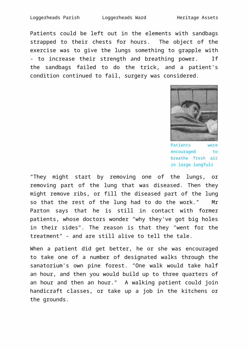
The vast site at Loggerheads was planted, at Dr Edwards' instruction, with pine trees, because he believed they purified the air. "On a good fresh day like today, we would wheel all the patients’ beds outside into the fresh air, so that they could get the fresh air into their lungs," remembers former head porter, Ted Parton. "We would line them up in neat rows. Of course, you would also wheel them out when it was frosty, or in the snow, and the snow would pile up on their beds - but it was thought to be good for them. We would also put sandbags on their chests while they were lying down."
Patients could be left out in the elements with sandbags strapped to their chests for hours. The object of the exercise was to give the lungs something to grapple with - to increase their strength and breathing power. If the sandbags failed to do the trick, and a patient's condition continued to fail, surgery was considered.
Patients were encouraged to breathe fresh air in large lungfuls
“They might start by removing one of the lungs, or removing part of the lung that was diseased. Then they might remove ribs, or fill the diseased part of the lung so that the rest of the lung had to do the work." Mr Parton says that he is still in contact with former patients, whose doctors wonder "why they've got big holes in their sides". The reason is that they "went for the treatment" - and are still alive to tell the tale.
Loggerheads Parish Loggerheads Ward Heritage Assets
When a patient did get better, he or she was encouraged to take one of a number of designated walks through the sanatorium's own pine forest. "One walk would take half an hour, and then you would build up to three quarters of an hour and then an hour." A walking patient could join handicraft classes, or take up a job in the kitchens or the grounds.
The catchment area for the sanatorium covered Liverpool and Cheshire, and many of the people who were sent there might never have seen the countryside before, and might not even have had the luxury of their own bed. That said the isolation which was deemed necessary could be very harsh for the sanatorium's inhabitants.
Although the regime seems fairly primitive by modern standards, it was in its time medically revolutionary and exciting.
Once diagnosed, patients were whistled away to sanatoria almost immediately. In the interests of public health, refusal to go was not an option. If you were a mother, you could quite easily go for years without seeing your children. And fraternising between patients of the opposite sex was strictly not allowed. But this was a time when doctors were deities, and the rest of the country was involved in the collective war effort.
The stigma attached to the disease itself meant that sanatorium staff were regarded with caution outside of the hospital gates. But the institution was like a reasonably sized village in itself. There were sporting activities arranged, social evenings and walks. The place even had its own cinema.
And then penicillin made its arrival at the sanatorium in the form of streptomycin. It was integrated into the treatment, and although the fresh air route to recovery was not entirely abandoned, the drug proved the more effective weapon in the fight against the lung disease. The sanatorium began to accept a wider range of diseases - cancer and heart patients - until it finally closed its doors in 1969.
"It was a marvellous place and its patients have very fond memories of it," says Mr Parton, adding: "In many ways it was like a golden age of looking after people."
The premises stood empty for a few years until Newcastle-under-Lyme Borough Council purchased the site for redevelopment in 1977. The sanatorium was demolished to make way for housing although some of the staff accommodations survive.
Loggerheads Parish Loggerheads Ward Heritage Assets
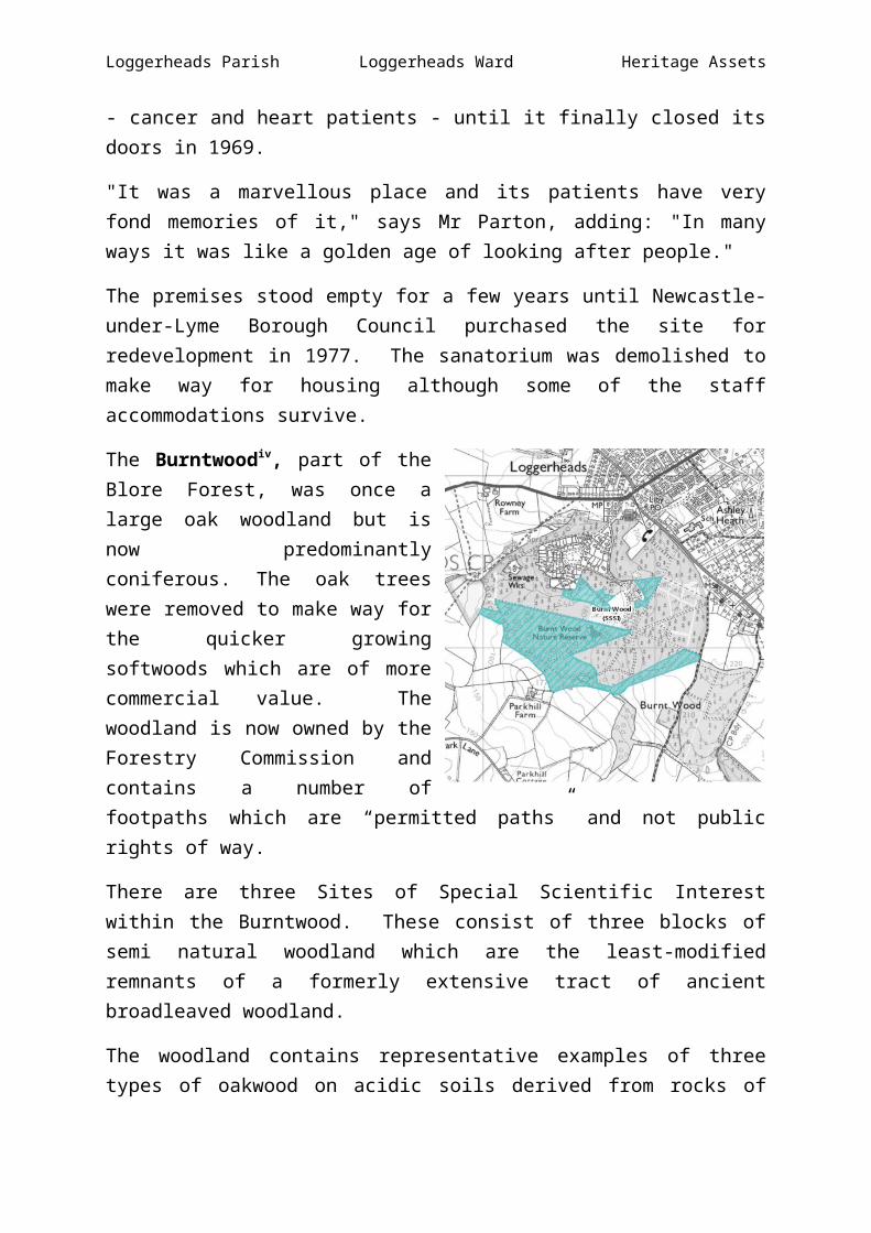
The Burntwoodiv, part of the Blore Forest, was once a large oak woodland but is now predominantly coniferous. The oak trees were removed to make way for the quicker growing softwoods which are of more commercial value. The woodland is now owned by the Forestry Commission and contains a number of footpaths which are “permitted paths” and not public rights of way.
There are three Sites of Special Scientific Interest within the Burntwood. These consist of three blocks of semi natural woodland which are the least-modified remnants of a formerly extensive tract of ancient broadleaved woodland.
The woodland contains representative examples of three types of oakwood on acidic soils derived from rocks of the Upper Coal Measures (Carboniferous) and Bunter Sandstone (Triassic). Such stands were formerly widespread in north Staffordshire but have been significantly reduced in area by reforestation and clearance. The site supports an outstanding terrestrial and freshwater fauna, with butterflies and moths Lepidoptera and caddis flies Trichoptera especially well represented.
The canopy is partly high forest and partly mature coppice dominated by birch and oak. The Pebble Beds of the Bunter Sandstone give rise to thin, dry, freely draining soil on which downy birch, rowan and holly are the main associates with the oak. The ground flora is typically species-poor with wavy hair-grass, bilberry and bracken, and locally, a county rarity, common cow-wheat. The soils which have developed from marls and sandstones of the Keele Beds (Upper Coal Measures) are silty or loamy clays, subject to seasonal waterlogging. These give rise to a second oak woodland type distinguished by the presence of hazel and a wider range of woody species including aspen, blackthorn, wild cherry and grey willow. The ground vegetation is dominated by bramble, bracken and broad buckler-fern, but mixtures of herbs such as wood-sorrel, bluebell, yellow archangel and honeysuckle are found locally. In scattered locations on very acid, leached soils a pedunculate oak – birch woodland type occurs as over-mature coppice. These woodlands are botanically impoverished with numerous cushions of the uncommon moss Leucobryum glaucum which are a characteristic feature. Where springs emerge on gentle slopes small pockets of alderwood add variety. Here the canopy consists of alder, downy birch, oak and ash over hazel and guelder-rose. The flushed wet ground is floristically diverse with plants such as common valerian and opposite-leaved golden-saxifrage.
Loggerheads Parish Loggerheads Ward Heritage Assets
At the junction of two soil types west of the cricket ground a flushed, ill-drained area supports lush herbaceous vegetation. The rich flora includes meadowsweet, ragged robin, common spotted-orchid, five species of sedge and abundant marsh violet. Other moisture-loving plant communities are confined to stream sides, old marl pits and ditches. Although of limited extent these are important habitats for invertebrates. Rides and other open areas, such as the young coppice below the electricity pylons, also add to the range of habitats attractive to invertebrates.
Almost four hundred species of Lepidoptera are recorded from Burnt Wood including the nationally restricted light orange underwing, golden rod brindle, bilberry pug and beautiful snout. Also present is a colony of small pearl-bordered fritillary– a species scarce in the Midlands – whose larva feeds on the abundance of marsh violet. The presence of some fifty species of caddis fly, including the nationally endangered Oligotricha clathrata, along with over thirty species of lacewing and the nationally rare hoverfly Xylota abiens demonstrate the value of the site for a wide range of invertebrates. Of the other fauna adders Vipera berus are a noteworthy occurrence.
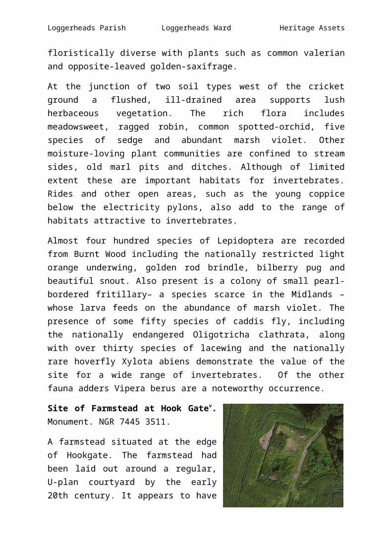
Site of Farmstead at Hook Gatev. Monument. NGR 7445 3511.
A farmstead situated at the edge of Hookgate. The farmstead had been laid out around a regular, U-plan courtyard by the early 20th century. It appears to have been demolished in the late 20th century. The farm appears to be represented by a single extant structure on the 1880s 1st Edition Ordnance Survey map, with the addition of a regular courtyard by the early 20th century (as shown on the 2nd Edition Ordnance Survey map). The farmstead was still extant in 1963, but had been demolished by 2000.
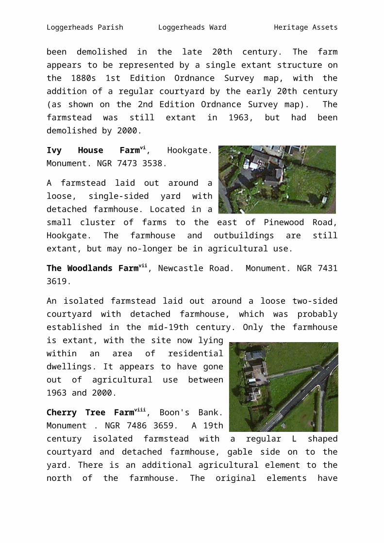
Ivy House Farmvi, Hookgate. Monument. NGR 7473 3538.
A farmstead laid out around a loose, single-sided yard with detached farmhouse. Located in a small cluster of farms to the east of Pinewood Road, Hookgate. The farmhouse and outbuildings are still extant, but may no-longer be in agricultural use.
The Woodlands Farmvii, Newcastle Road. Monument. NGR 7431 3619.
Loggerheads Parish Loggerheads Ward Heritage Assets
An isolated farmstead laid out around a loose two-sided courtyard with detached farmhouse, which was probably established in the mid-19th century. Only the farmhouse is extant, with the site now lying within an area of residential dwellings. It appears to have gone out of agricultural use between 1963 and 2000.
Cherry Tree Farmviii, Boon's Bank. Monument . NGR 7486 3659. A 19th century isolated farmstead with a regular L shaped courtyard and detached farmhouse, gable side on to the yard. There is an additional agricultural element to the north of the farmhouse. The original elements have undergone alterations, but the structure and plan remain extant and survive in agricultural use.
Westfields Farmix, Pinewood Road. Monument. NGR 7478 3588. An isolated farmstead laid out around a regular, L-plan courtyard. The farmstead was probably established in the mid-19th century and is still extant and in agricultural use, although with a large number of modern agricultural buildings now added around the original ranges.
Pinewood Farmx, Pinewood Road. Monument. NGR 7469 3543. A farmstead laid out around a loose, single-sided yard with farmhouse set gable-end on, located in a small cluster of farms to the east of Pinewood Road, Logggerheads. The farmstead appears to have been established by the 1830s and remains in agricultural use, although the farmhouse is the only original surviving element.
Rowney Farmxi, Drayton Road. Monument. NGR 7303 3591. An isolated farmstead laid out around a loose courtyard with main L-plan range and detached farmhouse and additional detached elements and two hay barns. The farmstead may have been established by the late 18th century and was certainly extant by the mid-19th century.
Loggerheads Parish Loggerheads Ward Heritage Assets
It is still extant and in agricultural use, although it has lost some of it original outbuilding ranges, with the remaining now converted to residential use.
Wickeytree Farmxii, Drayton Road. Monument. NGR 7257 3586.
An isolated farmstead laid out around a loose, two-sided courtyard with attached farmhouse and additional detached outbuildings. The farmstead may have been extant by the mid-19th century and survives in agricultural use, although with some alterations and additions.
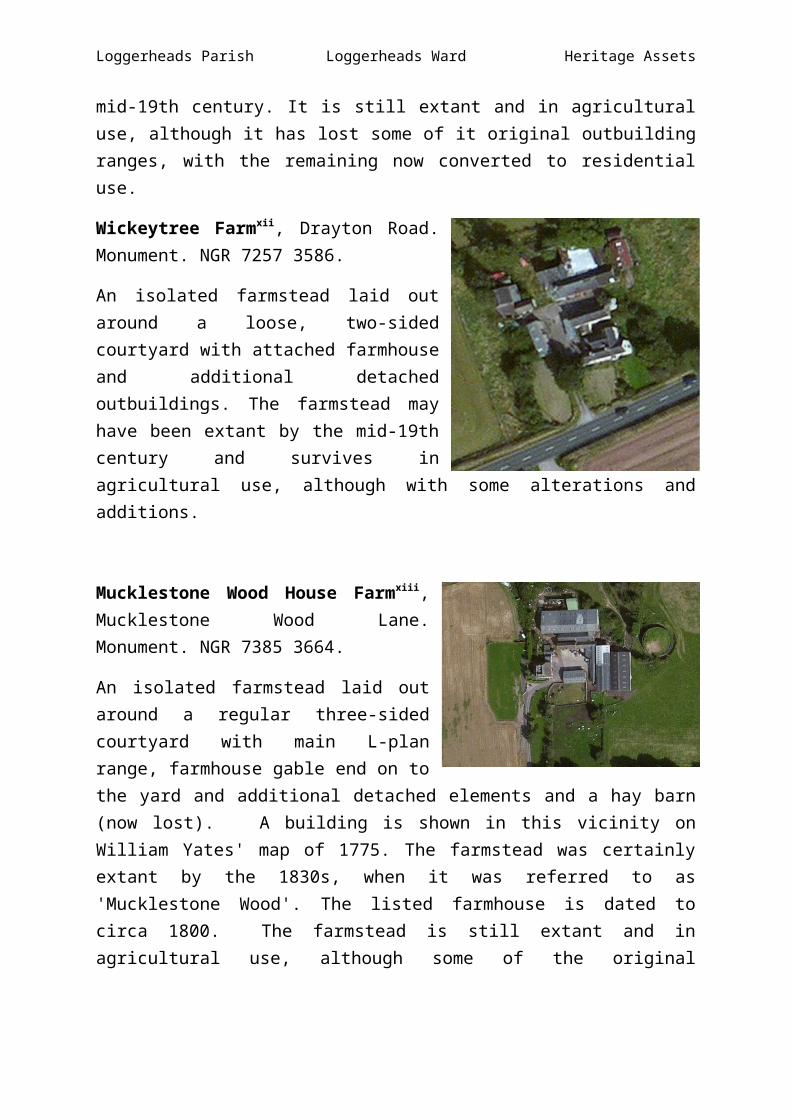
Mucklestone Wood House Farmxiii, Mucklestone Wood Lane. Monument. NGR 7385 3664.
An isolated farmstead laid out around a regular three-sided courtyard with main L-plan range, farmhouse gable end on to the yard and additional detached elements and a hay barn (now lost). A building is shown in this vicinity on William Yates' map of 1775. The farmstead was certainly extant by the 1830s, when it was referred to as 'Mucklestone Wood'. The listed farmhouse is dated to circa 1800. The farmstead is still extant and in agricultural use, although some of the original outbuildings now lost and new agricultural buildings now added to the north and east of the original ranges.
Loggerheads Parish Loggerheads Ward Heritage Assets
Map of Loggerheads Ward showing location of assets.
13 8
7
12
11 1 9
3 2 10
6
4 5
See overleaf for the assets located at each of the above sites.

Loggerheads Parish Loggerheads Ward Heritage Assets
Map Site Asset No. Asset1 xxxiii Milepost2 xxxiv Milepost3 xxxv Site of Cheshire Joint Sanatorium4 xxxvi Burntwood5 xxxvii Site of farmstead at Hook Gate6 xxxviii Ivy House Farm7 xxxix The Woodlands Farm8 xl Cherry Tree Farm9 xli Westfields Farm10 xlii Pinewood Farm11 xliii Rowney Farm12 xliv Wickeytree Farm13 xlv Mucklestone Wood House Farm
Loggerheads Parish Loggerheads Ward Heritage Assets

i ii iii iv v vi vii viii ix x xi xii xiii