Embed Size (px)
Citation preview
--UNCLASSIFIED--
--UNCLASSIFIED--
The Next GenerationTheater Geospatial Database
U.S. Army Pacific & U.S. Army Europe Geospatial Enterprise Solution
Dr.Eugene W.P. [email protected]
https://geopac.hi.pac.army.mil
Presented By
--UNCLASSIFIED--
--UNCLASSIFIED--
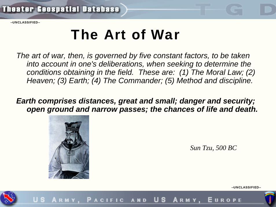
The Art of WarThe art of war, then, is governed by five constant factors, to be taken
into account in one's deliberations, when seeking to determine the conditions obtaining in the field. These are: (1) The Moral Law; (2) Heaven; (3) Earth; (4) The Commander; (5) Method and discipline.
Earth comprises distances, great and small; danger and security;open ground and narrow passes; the chances of life and death.
Sun Tzu, 500 BC
--UNCLASSIFIED--
--UNCLASSIFIED--
Objectives
• What & Why of TGD • Data Model • Hardware / Software Architecture • Enterprise Component (JIVA-V) • Future Enhancements
--UNCLASSIFIED--
--UNCLASSIFIED--
What is the TGD
The TGD is an enterprise solution focused on providing critical vector data in support of commanders, analysts, planners and systems. The TGD will greatly improve geospatial data collection, analysis, management and dissemination via the SIPRNET.
The TGD consists of:- Standard data model implemented on the Army’s
Digital Topographic Support System (DTSS)- Standard tools for creating and managing terrain
analysis data (i.e., ESRI ArcGIS, ArcSDE, PLTS; ERDAS Imagine)- Standard metadata scheme to enhance data discovery- Geospatial data visualization and dissemination
capability on the SIPRNet (JIVA-V, GLIDE, DGINet)- New “Information-based” business processes
--UNCLASSIFIED--
--UNCLASSIFIED--
5th EN DETAs the U.S. Pacific Command's (PACOM) Executive Agent for all
Pacific Theater terrain analysis and geospatial information, U.S. Army, Pacific has established a Pacific Theater Geospatial Database (TGD). A collaborative, three year, on-going effort with U.S. Army, Europe, define(ESRI), and with support from the Topographic Engineer Center (TEC), the TGD provides a unique geospatial data production, retrieval, and storage capability at a fidelity not currently offered by any other Department of Defense system or agency.
The TGD addresses critical Homeland Security intelligence analysis requirements by consolidating and disseminating extensive Pacific Theater, unique, digital, geospatial information and products.
In addition, the TGD allows intelligence analysts, planners, andoperators to integrate, seemingly disparate data to aid in pattern recognition, modeling, and visualization of the battle space.
--UNCLASSIFIED--
--UNCLASSIFIED--
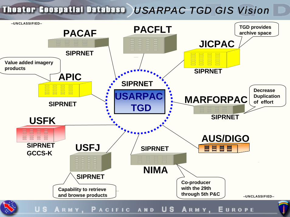
PACAF
SIPRNET
SIPRNETUSARPAC
TGD
SIPRNET
JICPAC
SIPRNET
TGD provides archive space
APICValue added imagery products
NIMA
SIPRNET
Co-producer with the 29th through 5th P&C
MARFORPACSIPRNET
Decrease Duplication of effort
PACFLT
USFJ
Capability to retrieve and browse products
SIPRNET
USFK
SIPRNET GCCS-K
AUS/DIGO
USARPAC TGD GIS Vision
--UNCLASSIFIED--
--UNCLASSIFIED--
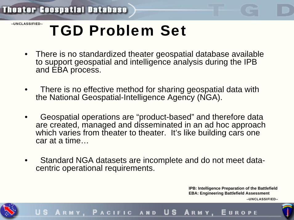
TGD Problem Set• There is no standardized theater geospatial database available
to support geospatial and intelligence analysis during the IPB and EBA process.
• There is no effective method for sharing geospatial data with the National Geospatial-Intelligence Agency (NGA).
• Geospatial operations are “product-based” and therefore data are created, managed and disseminated in an ad hoc approach which varies from theater to theater. It’s like building cars one car at a time…
• Standard NGA datasets are incomplete and do not meet data-centric operational requirements.
IPB: Intelligence Preparation of the BattlefieldEBA: Engineering Battlefield Assessment
--UNCLASSIFIED--
--UNCLASSIFIED--
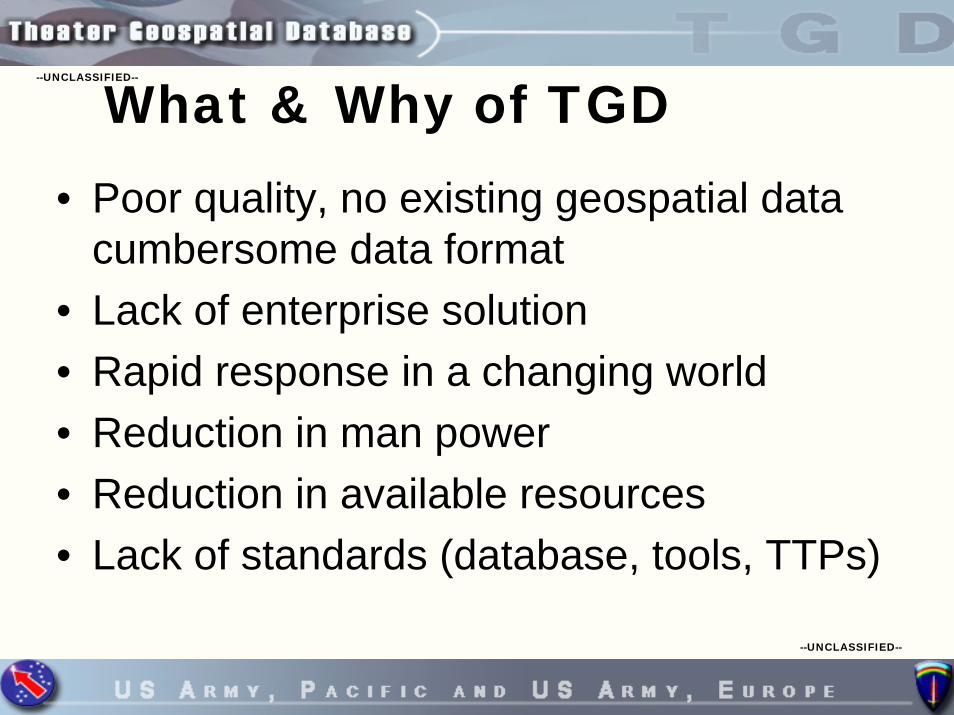
What & Why of TGD• Poor quality, no existing geospatial data
cumbersome data format• Lack of enterprise solution• Rapid response in a changing world• Reduction in man power• Reduction in available resources• Lack of standards (database, tools, TTPs)

--UNCLASSIFIED--
--UNCLASSIFIED--
TGD EssentialsThe TGD is a fusion of geospatial technologies, hardware, software,
information, and processes. The brain of a geospatial system is the database model. The TGD is base on a scaled down version of theNational Geospatial Intelligence Agency ( NGA) Feature Attribution Coding Catalog (FACC) data model standard and NGA’s Geospatial Intelligence Feature Database (GIFD).
GIFDUrban
Global
Tactical
Strategic
TGD

--UNCLASSIFIED--
--UNCLASSIFIED--
Geospatial Database GrowthIOC April 2004 to March 2006
• Strategic 6 GB - 7.5 GB• Global 2.6 GB - 2.7 GB• Tactical 120 MEG - 7.04 GB• Urban 40 MEG - 305 MEG
0.00E+00
2.00E+30
4.00E+30
6.00E+30
8.00E+30
Strategic(VMAP1)
Global(VMAP 0)
Tactical (VMAP2)
Urban (UVMAP)
April 04 IOC
Oct 04 CurrentMarch 06 Current
April 04 IOC

--UNCLASSIFIED--
--UNCLASSIFIED--
USARPAC TGD Data to NGA GIFD
GIFD

--UNCLASSIFIED--
--UNCLASSIFIED--
TGD 3 Data model

--UNCLASSIFIED--
--UNCLASSIFIED--
Enterprise TGDAGED=> Army Geospatial Enterprise DatabaseTGD=> Theater Geospatial DatabaseTAGD => Tactical Area Geospatial Database
EUCOM
TAGD
AGED
TGDTGD
TGDTGD
TAGDTAGDTAGDTAGD
DGInet
PACOM
ArcGis 9.2
Replication XML
M.PACOM M.EUCOM
ArcGis 9.2
Replication XMLM.TAGD
M.TAGD
NGA
MCIADIA

--UNCLASSIFIED--
--UNCLASSIFIED--
USAREUR TGD Web Site

--UNCLASSIFIED--
--UNCLASSIFIED--
USAREUR TGD IMS

--UNCLASSIFIED--
--UNCLASSIFIED--
USAEUR TGD Products

--UNCLASSIFIED--
--UNCLASSIFIED--
USARPAC TGD /NIPRNET

--UNCLASSIFIED--
--UNCLASSIFIED--
From Concept to Reality“Standing-up the TGD”
The “Front Door” of the TGD - NIPRNET
https://geopac.hi.pac.army.mil/

--UNCLASSIFIED--
--UNCLASSIFIED--
New Bridge
Updated Buildings
Updated VegetationNew Road
TGD at work

--UNCLASSIFIED--
--UNCLASSIFIED--
ReceiveRequestRequest
ValidateRequest
PriorityRelevancyNew Production
Internal Internal // External or Commodity data• Product / Data currency
ProductUpdates
TGD SDE
ProductServer
NewProduct
Yes
Customer
NoNew Data – Populates TGDProduct Updates systematically Updates SDE DB, Map Comp
Production Workflow
Data Contributors:CSIL NGAUSGS 1TOPO (ADF)NAVTEC TPIO-TDTEC GEOBASENGA USAREURMARFORPAC
Commodity Data
Dissemination
ValueAdded
Data Mining
DIGI NetSIPRNET FPTNIPRNET FTPINTRANET
PD# is on product fortracking and retrieval
Map
ping
Tab
les
Extraction
Original Product Data

--UNCLASSIFIED--
--UNCLASSIFIED--
Global Strategic Tactical
•1:5M-1:1M •1:500K-1:250K •1:100K-1;50
Urban
•25k- 7.5K
TGD Data (Data Model)VMAP Various Scales Commodity Data
•CSIL•USGS•NAVTEC•HOST information•GEOBASE•NGAUSAREUR•MARFORPAC•TEC•TPIO-TD•1TOPO (ADF)•NGA
Commodity DataMapping Tables
Data ModelData Load
TGDSDE
Data Models

--UNCLASSIFIED--
--UNCLASSIFIED--
TGD Functional Architecture
TGD Data Store
DTSS- ArcGIS 9.1- ERDAS 9.0
- Windows XP- SQL Server 2005- ArcSDE 9.1- Flat File Server
DGInet 4.0Map Service
(ArcIMS 9.1)
ArcSDE 9.1 (SQL Server)
ArcGIS 9.1
PLTS 9.1JTX
Hardcopy“Maps onDemand”
(TBD)
Vector Products (e.g. VITD)
Raster Products (e.g. DTED)
Data Ingest
Data & Product Output
Data Editing & Maintenance Data Dissemination (DGInet)
Data Analysis(External to TGD Development)
Production Data(reduced schema)
Metadata(ICML format)
Tactical Decision Aids (TDAs)
Reference Data(DGInet Raster)
Reference DataVITD, VMap, DNC,LWD, UVMap, EUVMap
Digital VectorProduct Data
DTED, CADRG, CIB
Digital RasterProduct Data
Imagery
HardcopyMap Sources
Product Data(raster, vector, flat files)
Metadata
Production Data- Global- Strategic- Tactical- Urban
MetadataTool
AdminTool
Distributed Editing
Hardcopy Map Products
(TBD)

--UNCLASSIFIED--
--UNCLASSIFIED--
TGD Architecture
JIVA-V/DGINet/GLIDE Server
TGD Production Server
DGINet Nodes
JIVA-V/DGINet/GLIDE Server
Intel Database Server
SIPRNETSIPRNET
DGINet Nodes
JWICSJWICS
Users
Users
GeospatialData “Push”
Process
JWICS LAN
SIPRNET LAN

--UNCLASSIFIED--
--UNCLASSIFIED--
USARPAC TGD Network

--UNCLASSIFIED--
--UNCLASSIFIED--
Data ProductionData Production
TGD Software
Data ManagementData Management
Production Line Tool Set (PLTS) Job Tracking Extension (JTX)
CTIS Tactical Decision Aid Software
Production Line Tool Set (PLTS) Job Tracking Extension (JTX)
CTIS Tactical Decision Aid Software
ArcGISArcGIS ImagineImagine SOCET SETSOCET SET
ArcSDEArcSDE SQL ServerSQL Server ArcCatalogArcCatalog
Data AcquisitionData Acquisition
Data MasterData Master Sky MediaSky Media GBSGBS
Data/Product Visualization and DisseminationData/Product Visualization and Dissemination
JIVA-VJIVA-V DGINetDGINet Geo ProductsGeo Products Geo RFIGeo RFI

--UNCLASSIFIED--
--UNCLASSIFIED--
Enterprise Component
• Joint Intelligence Virtual Architecture – Visualization (JIVA-V): Provides capability to quickly and easily find, display, overlay and fuse geospatial data from multiple sources.
• Distributed Geospatial Intelligence Network (DGINet): Provides analysts the capability to rapidly locate and display data residing locally or at remote sites world-wide.
• Geographically Linked Information Dissemination Environment (GLIDE): Provides the capability to quickly locate, display and download geospatial products from anywhere on the network.

--UNCLASSIFIED--
--UNCLASSIFIED--
Non-GIS Developer/ User Clients
•Custom web Application
DGInet Data Management
Data Prep tool
Metadata Card
DGInet Database
Admin Tools
What Is JIVA-V/DGInet?DGInet Clients
Internet Explorer
DGInet Explorer
DGInet Web Services
DGInet Web Services
DGInet External Services
Data Production
Geospatial WS-Vector/Raster-Ops/Intel
Standard Products-NGA -Commercial-Other
Data Producers Data Consumers
GIS Developer/User Clients
•GIS WS•Other ArcIMS Services
Text WS-Intel Reports
CGI/XML ICD
Standard SDE Call
JPEG/PNG
JPEG

--UNCLASSIFIED--
--UNCLASSIFIED--
DGInet Operational SIPRNET Nodes
SIPRNET1 ActiveUSPACOMJFICMCIA (GLIDE)NGIC (Prototype)
SIPRNET PlannedDIACNGIC (Operational)1st MEF 2nd MEF3rd MEFUSTRANSCOMJIOC (AIA)
SIPRNET2 ActiveUSARURUSARPACNAVODTRANGA*

--UNCLASSIFIED--
--UNCLASSIFIED--
From Concept to Reality“Standing-up the TGD”
The “Front Door” of the TGD - SIPRNET

--UNCLASSIFIED--
--UNCLASSIFIED--
DGInet Data Providers

--UNCLASSIFIED--
--UNCLASSIFIED--
Disconnected EditingTGD formsInitial “map”baseline
Checkout missiondataset
Check-Out
Check-OutCheck-In
Check-In Check-Out
Check-In
Check-InData to TGD
Check-outsTo individualArcPad devices

--UNCLASSIFIED--
--UNCLASSIFIED--
U.S. Army Transformation 5th EN DET (P&C) to 5th GPC
• 5th EN DET, 11 Mil 1DA Civ, 5 contractors
• 5th GPC, Oct 2007 27 Mil ? DA Civ, ? contractors
• 60th EN DET• 60th GPC, Spring 2007

--UNCLASSIFIED--
--UNCLASSIFIED--
HQ USAREURHQ USAREUR 60TH Eng Det (P&C)2 1 7 10
60TH Eng Det (P&C)2 1 7 10
HQ, V CORPSHQ, V CORPS
1 AD1 AD 1 ID1 ID
XXXX
XX
XXX
XX
Terrain Platoon1 1 22 24
Terrain Platoon1 1 22 24
510TH Eng Det1 0 2 3
510TH Eng Det1 0 2 3
517TH DET0 0 6 6
526TH Eng Det1 0 2 3
526TH Eng Det1 0 2 3
518TH DET0 0 6 6
DTSS-B DTSS-D DATA MANAGEMENTPLANNING & CONTROL
DTSS-D TERRAIN ANAL
DTSS-H DTSS-D TERRAIN ANAL 1
320TH Eng Co3 1 82 86
DTSS-H DTSS-D TERRAIN ANAL 1
320TH Eng Co3 1 82 86
DTSS-H DTSS-D PRINT SQDGRAPHIC SQDSUVERY SQD 2TERRAIN ANAL 4
•••
•••
USAREUR Organization

--UNCLASSIFIED--
--UNCLASSIFIED--
Future Enhancements• TGD 3
– Raster Geospatial Database– Glide features (Zip and Ship)
• TGD 4• Improved database performance• Automatic Feature extraction• Automatic Map generation• Automatic Feature change notification

--UNCLASSIFIED--
--UNCLASSIFIED--
Points of ContactUSAREUR
Ronald W. Bijeau (Ch, GI&S Branch)DSN: 314-370-6820 COM: 011-49-(0)6221-57-6820 NIPRNet: [email protected] SIPRNet: [email protected]
Todd M. Minnich (Program Manager) Theater Geospatial Database Tompkins Barracks, Germany 314-379-9435 [email protected]
Kristin A. Fishburn (Geospatial Database Engr)HQUSAREUR 60th ENG DET DSN (314) 379-9431 +49 (0)6202-809431 Fax: DSN (314) 379-9434, +49 (0)6202-809434 [email protected]
TGD DGInet (SIPRnet): http://tgd.60engdet.hqusareur.army.smil.mil/jiva/start.html
USARPAC
MAJ Curtis Edson (USARPAC GI&S Officer)DSN: [email protected]
Dr. Eugene Bingue (TGD Program Mgr, USARPAC-G2/ 5th En Det)COM: [email protected]
Ryan Kakazu (Geospatial IT)COM: [email protected]
NGA (USARPAC-G2)Bryce Wyble (Senior NGA /USARPAC-G2, GIS)DSN: 4388-1559COM: [email protected]
TGD DGInet (SIPRNET): http://128.80.136.007/jiva/start.htmlSIPRNET: http://128.80.136.192NIPRNET: https://geopac.hi.pac.army.mil/
TEC
Denise Hovanec (TEC TGD Lead)
COM: 703-785-5624
NIPRnet: [email protected]

--UNCLASSIFIED--
--UNCLASSIFIED--
Glossary• LINCS – Long-range Information Networked Communications Services• TGD – Theater Geospatial Database• Jiva-V - Joint Intelligence Virtual Architecture – Visualization • DGINet - Distributed Geospatial Intelligence Network• GLIDE - Geographically Linked Information Dissemination Environment• DTSS - Digital Topographic Support System• NGA - National Geospatial-Intelligence Agency• IPB - Intelligence Preparation of the Battlefield• EBA - Engineering Battlefield Assessment

--UNCLASSIFIED--
--UNCLASSIFIED--
AttributionThe following people took part in the ongoing development and implementation
of the TGD:
• USAREUR – Todd M. Minnich , Ron Bijeau, Kristin A. Fishburn
• USARPAC – Dr. Eugene Bingue, MAJ Curtis Edson , CW3 Loren Small, Ryan Kakazu
• ESRI – Jim Ciarrocca, John Grammer, Jack Miller
• USATEC – Dennise Hovanec, Mark Hainsey
• DIA – Terry Busch

--UNCLASSIFIED--
--UNCLASSIFIED--
Questions
"A map says to you, Read me carefully, follow me closely,doubt me not, I am the earth in the palm of your hand"
Beryl Markham -- aviator and author