Embed Size (px)
Citation preview

Management of Victoria’s Ramsar Wetlands
Strategic Directions Statement

PAGE I STRATEGIC DIRECTIONS STATEMENT FOR MANAGEMENT OF VICTORIA'S RAMSAR WETLANDS
Parks Victoria developed the Strategic Directions Statement in conjunction with the Department of Natural Resources and Environment and key stakeholders, and coordinated the public comment process on the draft document.
This report was prepared with financial support from the National Wetlands Program, under the Natural Heritage Trust.
© The State of Victoria, Department of Natural Resources and Environment, 2002
This publication is copyright. Apart from any fair dealing for the purposes of private study, research, criticism or review as permitted under the Copyright Act 1968, no part may be reproduced, copied, transmitted in any form or by any means (electronic, mechanical or graphic) without the prior written permission of the State of Victoria, Department of Natural Resources and Environment. All requests and enquiries should be directed to the Copyright Officer, Library Information Services, Department of Natural Resources and Environment, 5/250 Victoria Parade, East Melbourne, Victoria 3002.
DisclaimersThis publication may be of assistance to you and every effort has been made to ensure that the information in the report is accurate. The Department of Natural Resources and Environment does not guarantee that the report is without flaw of any kind or is wholly appropriate for your particular purposes and therefore disclaims all liability for any error, loss or other consequence which may arise from you relying on any information in this publication.
The views and opinions expressed in this document are those of the authors and do not necessarily reflect the views and opinions of the Commonwealth Government of Australia, the Federal Minister for Environment and Heritage, or Environment Australia.
This report is prepared without prejudice to any negotiated or litigated outcome of any native title determination applications covering land or waters within the plan's area. It is acknowledged that any future outcomes of native title determination applications may necessitate amendment of this report; and the implementation of this plan may require further notifications under the procedures in Division 3 Part 2 of the Native Title Act 1993 (Cwlth).
The plan is also prepared without prejudice to any future negotiated outcomes between the Government/s and Victorian Aboriginal communities. It is acknowledged that such negotiated outcomes may necessitate amendment of this plan.
Published in May 2002 by the Department of Natural Resources and Environment Level 14, 8 Nicholson Street, East Melbourne, Victoria 3002
Copies of this document are available at www.nre.vic.gov.au
National Library of Australia Cataloguing-in-
Publication entry
Victoria. Department of Natural Resources and Environment.Management of Victoria's Ramsar Wetlands: Strategic Directions Statement
Bibliography.
ISBN 1 74106 015 X
Cover: Western Port saltmarsh community (Photograph: Parks Victoria collection)
Printed on recycled paper

PAGE I STRATEGIC DIRECTIONS STATEMENT FOR MANAGEMENT OF VICTORIA'S RAMSAR WETLANDS

Executive Summary
Australia is one of 130 countries recognised as a Contracting Party to the Convention on Wetlands (Ramsar, Iran, 1971), commonly known as the 'Ramsar Convention'. The Ramsar Convention was the first international treaty to consider the conservation of natural resources, with a particular focus on protecting habitat for waterbirds. Since 1971, the Ramsar Convention has broadened its focus to take into account the wide range of human uses associated with wetlands such as primary production, recreation, and cultural uses.
The primary objective of the Ramsar Convention is to promote the conservation, repair and wise use of all wetlands, with a particular emphasis on sites that have been designated as Wetlands of International Importance, or 'Ramsar sites'. The Convention advocates the wise (i.e. sustainable) use of wetlands worldwide and encourages Contracting Parties to manage wetlands within their territory in accordance with the Ramsar 'wise use' guidelines. Under existing constitutional arrangements in Australia, each State and Territory plays a significant role in implementing the Ramsar Convention, including responsible management of its Ramsar sites.
Victoria currently has 11 Ramsar sites within its jurisdiction. Ten of these were listed in 1982 and are specifically covered by this plan. They are: Barmah Forest, Corner Inlet, Gippsland Lakes, Gunbower Forest, Hattah-Kulkyne Lakes, Kerang Wetlands, Lake Albacutya, Port Phillip Bay (Western Shoreline) and Bellarine Peninsula, Western District Lakes and Western Port. The Edithvale-Seaford Wetlands Ramsar site was listed in 2001. Although not specifically covered by this plan, the policy framework and management objectives are intended to apply to all current and future Ramsar sites in Victoria.
The value of Ramsar sites both individually and as a collective asset is unquestionable. Victoria's Ramsar wetlands provide habitat and water refuge in drought for a large number of threatened and endangered species, contribute to the State's economy through primary production and recreation, control flooding, and perform a number of natural functions including the removal of excess nutrients from our waterways.
However, Victoria's Ramsar sites have been, and continue to be, exposed to a number of risks including altered water regimes, salinity, pollution, pest plants and animals, grazing and fire. The sites are located across the State and are managed by a number of different site managers. The Strategic Directions Statement provides a response to the
risks to the inherent values of Victoria's Ramsar sites across the State and promotes their coordinated management.
The Strategic Directions Statement is guided by the principle of wise use under the Ramsar Convention, and complements both the Commonwealth Wetlands Policy, and iictoria's Biodiversity: Directions in Management (NRE, 1997) which set the policy direction for managing Victoria's wetland resources. The Strategic Directions Statement establishes a policy and planning context for Ramsar sites by outlining the above documents as well as other legislation and policy which is relevant to the planning and management of sites. Given the available array of policy tools, Victoria has the capacity to deliver on its Ramsar obligations.
An understanding of the nature and distribution of the key environmental, cultural, economic and scientific values is an essential input to planning the management of Victoria's Ramsar sites. The Strategic Directions Statement outlines these values and the risks that may adversely affect them. Based on the policy framework and analysis of risks and values, the following Management Objectives have been established for Victoria's Ramsar sites.
1. Increase the scientific understanding of wetland ecosystems and their management requirements.
2. Maintain or seek to restore appropriate water regimes.
3. Address adverse processes and activities.
4. Manage within an integrated catchment management framework.
5. Manage resource utilisation on a sustainable basis.
6. Protect, and where appropriate enhance, ecosystem processes, habitats and species.
7. Encourage strong partnerships between relevant agencies.
8. Promote community awareness and understanding, and provide opportunities for involvement in management.
9. Ensure recreational use is consistent with the protection of natural and cultural values.
10. Develop ongoing consistent programs to monitor ecological character.
A number of Statewide Management Strategies have been developed to assist in the achievement of these objectives. To optimise the targeting of resources these Strategies have been prioritised on
STRATEGIC DIRECTIONS STATEMENT FOR MANAGEMENT OF VICTORIA'S RAMSAR WETLANDS PAGE II

a statewide basis. The Strategic Directions Statement also sets out the responsibilities of site managers and agencies and assigns to them accountability for the implementation of Strategies.
To better address issues at the site level, Strategic Management Plans for each of the 10 Ramsar sites listed in 1982 are being developed to further detail values and risks to these values. The Strategic Management Plans take the Strategic Directions Statement one step further by promoting a range of specific management actions that will maintain, and in some cases enhance, the ecological character of Victoria's Ramsar sites.
The Strategic Directions Statement is Victoria's response to the need to develop an integrated management framework for its Ramsar sites. This need is directed by the Australian Ramsar
Management Principles established by the Environment Protection and Biodiversity Conservation Act 1999 and the Environment Protection and Biodiversity Conservation Regulations 2000 (Cwlth). The Strategic Directions Statement, in conjunction with the Strategic Management Plans for each Ramsar site, will place Victoria in a better position to address Australia's obligations under the Ramsar Convention. Consistent with the Australian Ramsar Management Principles, particular emphasis has been placed on maintaining ecological character at each of Victoria's Ramsar sites.
A reporting framework forms part of the Strategic Directions Statement to enable reporting at the State, national and international level, and to provide a basis for reviewing management strategies and associated priorities.
STRATEGIC DIRECTIONS STATEMENT FOR MANAGEMENT OF VICTORIA'S RAMSAR WETLANDS PAGE III

Acknowledgments
The project 'Management Strategies for Victoria's Ramsar Sites' is being undertaken by Parks Victoria in conjunction with the Department of Natural Resources and Environment (NRE). Many people were involved in the project.
The National Parks Policy and Strategy Division of Parks Victoria managed the project with significant contributions from Paul Dartnell, David Young, Sally Troy, Linda Greenwood, Nicole Brown and Ben Churchill. The completion of the Strategic Directions Statement was augmented by project teams across the State who worked tirelessly on individual Strategic Management Plans for 10 of Victoria's 11 Ramsar sites. The project teams, comprising Environmental Chief Rangers, relevant District Chief Rangers and park staff across the State, were coordinated by Simon Casanelia, Kate Maltby and Colin Leigh (from the National Parks Policy and Strategy Division).
Key stakeholders and other land managers (including NRE) provided invaluable advice as part of Local Reference Groups and demonstrated great enthusiasm towards achieving the best possible management outcome for the sites.
The strategic advice of the Steering Committee established to provide technical input to the project is appreciated. The Steering Committee was convened by Paul FitzSimons (Parks Flora and Fauna Division of NRE) and included representatives from Environment Australia (initially Ben Churchill, then Peter Cotsell), and relevant NRE businesses including Executive Services (Sharon MacDonnell and Scott Ashby), Fisheries Victoria (John Garnham), Parks Flora and Fauna Division of NRE (Andrew Corrick), Catchment Management and Sustainable Agriculture (Julia Reed) and Forests Service (Andrew Maclean). Janet Holmes (Parks Flora and Fauna Division of NRE) provided advice and managed the approval process.
The consultants Biosis Research Pty Ltd assisted in the early stages of preparing this document.
The following organisations and individuals provided written comment as part of the public submission process:
Australasian Wader Study Group
Australian Conservation Foundation
Birds Australia
Chris Harty Planning and Environmental Management
City of Greater Geelong
Coalition Against Duck
Shooting
Corangamite Catchment Management
Authority Department of Infrastructure
Environment Australia
Field and Game Australia Inc.
Field Naturalists Club of Ballarat Inc.
Fisheries Victoria (NRE)
Gutowski, Angie (NRE Gippsland Region)
Norris, Michael
North Central Catchment Management
Authority Forests Service (NRE)
Sieler, Ingrid (Parks
Victoria) Soren, Jody
Swan Bay Integrated Catchment Management Committee
Victorian National Parks
Association Victorian Wader Study
Group Inc.
Westernport and Peninsula Protection Council Inc.
STRATEGIC DIRECTIONS STATEMENT FOR MANAGEMENT OF VICTORIA'S RAMSAR WETLANDS PAGE IV

Contents
FOREWORD I
EXECUTIVESUMMARY I I
ACKNOWLEDGMENTS IV
1 INTRODUCTION 1
1.1 STRATEGIC MANAGEMENT OF VICTORIA'S RAMSAR SITES 11.2 STRUCTURE OF THE STRATEGIC DIRECTIONS STATEMENT 2
2 RAMSARSITESINVICTORIA 3
2.1 OVERVIEW OF VICTORIA'S RAMSAR SITES 32.2 RAMSAR CRITERIA MET BY VICTORIA'S RAMSAR SITES 72.3 LAND TENURE AND MANAGEMENT AGENCY 7
3 P OLICY FRAMEWORK 10
3.1 RAMSAR CONVENTION 103.2 OTHER INTERNATIONAL AGREEMENTS 113.3 COMMONWEALTH GOVERNMENT POLICY AND LEGISLATION 123.4 VICTORIAN GOVERNMENT POLICY AND LEGISLATION 13
4 VALUES 16
4.1 WETLAND REPRESENTATIVENESS 164.2 FLORA AND FAUNA 164.3 WATERBIRDS 174.4 NATURAL FUNCTION 184.5 CULTURAL HERITAGE 184.6 SCENIC 184.7 ECONOMIC184.8 EDUCATION AND INTERPRETATION 194.9 RECREATION AND TOURISM 194.10 SCIENTIFIC 20
5 MANAGEMENT OF RISKS 2 1
5.1 ALTERED WATER REGIMES 215.2 SALINITY 225.3 POLLUTION225.4 PEST PLANTS AND ANIMALS 235.5 RESOURCE UTILISATION 235.6 DREDGING 24
STRATEGIC DIRECTIONS STATEMENT FOR MANAGEMENT OF VICTORIA'S RAMSAR WETLANDS PAGE V

5.7 RECREATION 245.8 FIRE 255.9 LEVEL OF RISK TO RAMSAR VALUES 25
6 MANAGEMENTFRAMEWORK 2 7
6.1 INTRODUCTION 276.2 MANAGEMENT OBJECTIVES 276.3 STATEWIDE MANAGEMENT STRATEGIES 27
7 STATEWIDEMANAGEMENTSTRATEGIES 28
8 IMPLEMENTATION ANDREPORTINGFRAMEWORK 32
REFERENCES 33
APPENDIX 1 MANAGEMENTPLANSANDSTRATEGIES 34
APPENDIX 2 RAMSARWETLANDCATEGORIES FOR VICTORIA'SRAMSARSITES 36
APPENDIX 3 AREA OF WETLAND TYPE ATVICTORIA'SRAMSARSITES 38
APPENDIX 4 ACTIONSTATEMENTRECOMMENDATIONS (FFG ACT1988) 39
APPENDIX 5 POTENTIALLYTHREATENINGPROCESSES (FFG ACT1988) 41
APPENDIX 6 AUSTRALIANRAMSARMANAGEMENTPRINCIPLES 43
APPENDIX 7 RISKASSESSMENT METHODOLOGY 45

STRATEGIC DIRECTIONS STATEMENT FOR MANAGEMENT OF VICTORIA'S RAMSAR WETLANDS PAGE VI
listed under the Convention, including 11 sites in Victoria.
Victoria, in common with other States and Territories, administers its obligations under the Ramsar Convention in partnership with the Commonwealth Government. The Department of Natural Resources and Environment is the administrative authority responsible for implementing the Ramsar Convention in Victoria.
The Strategic Directions Statement is one of 11 documents developed to establish consistent and appropriate management for 10 of Victoria's Ramsar sites (Figure 1.2). The purpose of the Strategic
Ramsar Site
Barmah Forest
Area (ha)
28,515
Corner Inlet 67,192
Gippsland Lakes 60,015
Gunbower Forest 19,931
Hattah-Kulkyne Lakes 955
Kerang Wetlands 9,419
Lake Albacutya 5,731
Port Phillip Bay (Western Shoreline) 22,897
Western District Lakes 32,898Directions Statement is to:
Western Port 59,297
1 Introduction
1.1 Strategic management of Victoria's Ramsar sites
The development of this Strategic Directions Statement is a component of an integrated program to develop comprehensive Strategic Management Plans for 10 of Victoria's Ramsar sites listed under the Convention on Wetlands (Ramsar, Iran, 1971). Table 1.1 below lists the 10 Ramsar sites in Victoria covered by the integrated planning program.
In August 2001, a new Ramsar site, the Edithvale- Seaford Wetlands, was listed for Victoria. The Edithvale-Seaford Wetlands are not specifically covered by the integrated planning program, although the policy framework, management objectives and strategies in the Strategic Directions Statement are intended to apply to all current and future Ramsar sites in Victoria. A separate plan for the Edithvale-Seaford Wetlands was developed by Melbourne Water Corporation in 2000 as part of the Ramsar listing process.
The Ramsar Convention on Wetlands is an inter- governmental treaty that provides the framework for international cooperation for the conservation of wetlands, one of the most threatened habitats in the world. There are currently 1,150 wetlands listed under the Ramsar Convention covering a total area of 96.3 million hectares.
As a Contracting Party to the Ramsar Convention, Australia is required to meet a number of obligations including the maintenance of the ecological character of its Ramsar sites through conservation and wise use. As of 2002, Australia has 57 sites
maintenance of ecological character and the wise use of Victoria's Ramsar sites;
• address the requirements of Government legislation, policy and planning in relation to management of Victoria's Ramsar sites; and
• set out the responsibilities of Ramsar site managers and agencies with specific roles and promote coordinated management of Victoria's Ramsar sites.
The Strategic Directions Statement establishes Management Objectives for management of Ramsar sites and Statewide Management Strategies to achieve these objectives. The individual Strategic Management Plans for Victoria's Ramsar sites apply the Management Objectives and Statewide Management Strategies, promoting a range of specific management actions that will maintain and, in some cases, restore the ecological character of the sites.
The Strategic Directions Statement and Strategic Management Plans promote effective cooperation between agencies, local government and private landowners and establish management responsibilities. The documents are being developed through the efforts of project teams across the State with significant input from key stakeholders and members of Local Reference Groups. Input from the broader community was sought through a public consultation process, and all comments received were carefully considered in finalising this document.
Table 1.1 Victoria's Ramsar sites covered by the integrated planning program
• establish a framework for the management of Ramsar sites in the Victorian context;
• address Australia's obligations under the Ramsar Convention particularly in relation to the
TOTAL 306,850
STRATEGIC DIRECTIONS STATEMENT FOR MANAGEMENT OF VICTORIA'S RAMSAR WETLANDS PAGE 1

BARMAH FOREST
CORNER INLET
GIPPSLAND LAKES
GUNBOWER FOREST
KERANG WETLANDS
H
ATTAH- K
LAKES
LAKE ALBACUTYA
PORT PHILLIP BAY
W
ESTERN D
LAKES
WESTERN
The development of this strategic approach to management of the sites (i.e. through the preparation of the Strategic Directions Statement and the separate Strategic Management Plans for 10 of Victoria's Ramsar sites) is consistent with the Australian Ramsar Management Principles. The implementation of actions identified in this suite of documents will make an important contribution to meeting Australia's obligations under the Ramsar Convention.
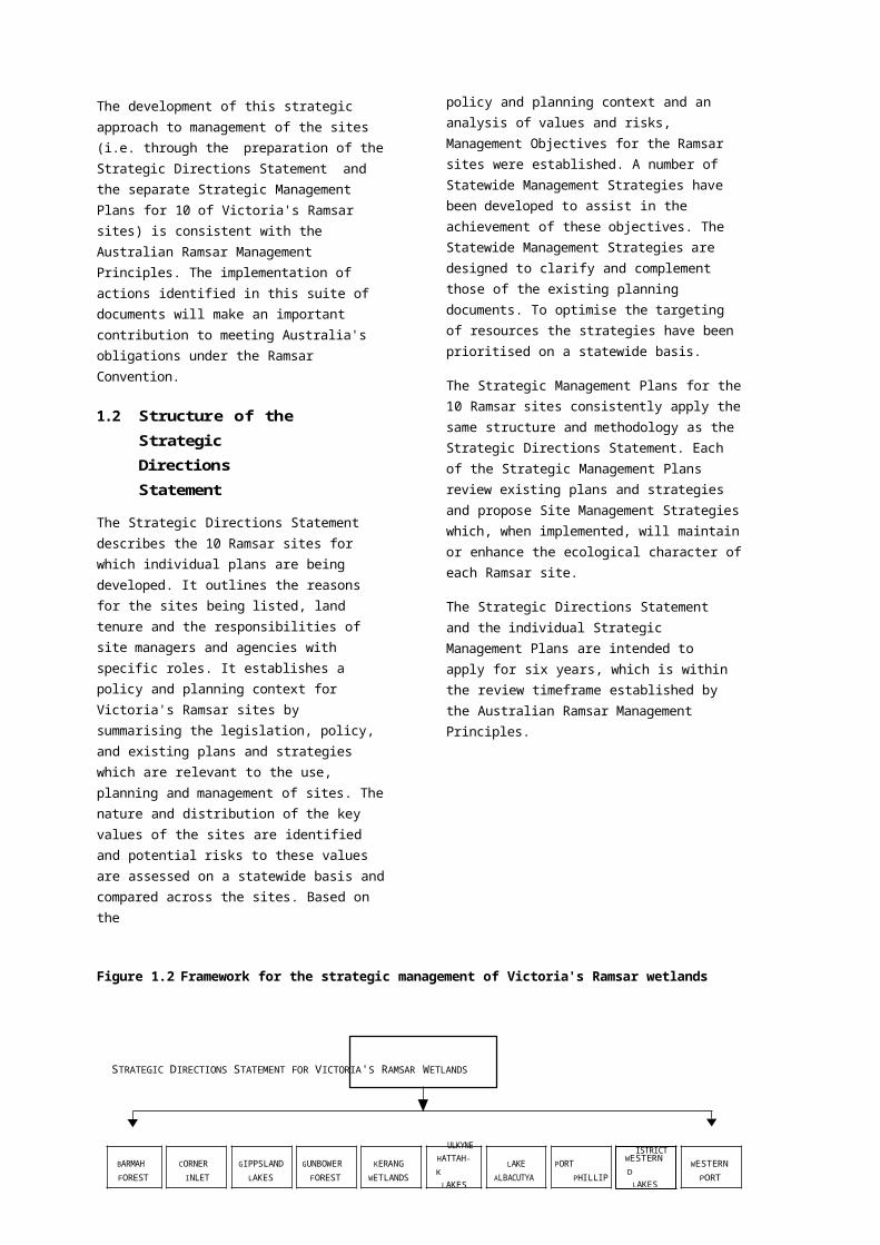
1.2 Structure of the Strategic Directions Statement
The Strategic Directions Statement describes the 10 Ramsar sites for which individual plans are being developed. It outlines the reasons for the sites being listed, land tenure and the responsibilities of site managers and agencies with specific roles. It establishes a policy and planning context for Victoria's Ramsar sites by summarising the legislation, policy, and existing plans and strategies which are relevant to the use, planning and management of sites. The nature and distribution of the key values of the sites are identified and potential risks to these values are assessed on a statewide basis and compared across the sites. Based on the
policy and planning context and an analysis of values and risks, Management Objectives for the Ramsar sites were established. A number of Statewide Management Strategies have been developed to assist in the achievement of these objectives. The Statewide Management Strategies are designed to clarify and complement those of the existing planning documents. To optimise the targeting of resources the strategies have been prioritised on a statewide basis.
The Strategic Management Plans for the 10 Ramsar sites consistently apply the same structure and methodology as the Strategic Directions Statement. Each of the Strategic Management Plans review existing plans and strategies and propose Site Management Strategies which, when implemented, will maintain or enhance the ecological character of each Ramsar site.
The Strategic Directions Statement and the individual Strategic Management Plans are intended to apply for six years, which is within the review timeframe established by the Australian Ramsar Management Principles.
Figure 1.2 Framework for the strategic management of Victoria's Ramsar wetlands
STRATEGIC DIRECTIONS STATEMENT FOR VICTORIA'S RAMSAR WETLANDS
ULKYNE ISTRICT
STRATEGIC DIRECTIONS STATEMENT FOR MANAGEMENT OF VICTORIA'S RAMSAR WETLANDS PAGE 2

1
2 Ramsar Sites in Victoria
The 10 Ramsar sites covered by the integrated planning program are located across the State from Western Victoria to East Gippsland (Figure 2.1). Outline information on the individual sites is provided below. Further information on each Ramsar site is available in the respective Strategic Management Plans.
Figure 2.1 Location of Victoria's Ramsar sites
2.1 Overview of Victoria's Ramsar
sites Barmah ForestLocation: Northern Victoria on the Murray River floodplain between Barmah and Tocumwal.
Area: 28,515 ha
Bioregion : Riverina
Description: A variety of permanent and temporary wetlands including lakes, swamps, billabongs, grassland plains and seasonally flooded Red Gum forest.
Significant value: Barmah Forest is the largest River Red Gum forest in Victoria.
Use: Conservation, forestry, grazing and recreation.
Tenure: State Park, State Forest and other public land2.3 2
Catchment : Goulburn Broken Catchment Management Authority area (24,067 km ) supports a populationof approximately 200,000. The primary land uses are agriculture (dryland and irrigated) and forestry.
Adjacent use: Agriculture, recreation and Millewa State Forest in New South Wales.
Site Manager: Parks Victoria and NRE.
1 Bioregions are based on the Interim Biogeographic Regionalisation of Australia (Thackway and Cresswell 1995). 2 Public land tenure is discussed in Section 2.3. 3 Catchment Management Authority areas have been used as information was more consistently available at this scale.
STRATEGIC DIRECTIONS STATEMENT FOR MANAGEMENT OF VICTORIA'S RAMSAR WETLANDS PAGE 3

Corner InletLocation: Southern Victoria between Wilsons Promontory and Yarram.
Area: 67,192 ha
Bioregion: South East Coastal Plain
Description: Deep water, intertidal flats, salt marshes and mangroves and higher ground of numerous islands.
Significant value: Corner Inlet is the most southerly marine embayment and tidal mudflat system of mainland Australia and the world's most southerly occurrence of White Mangrove.
Use: Conservation, fishing (commercial), recreation and port.
Tenure: Marine and Coastal Park, other protected areas, private and other public land.
Catchment: West Gippsland Catchment Management Authority area (17,275 km2) supports a population of approximately 192,000. The primary land uses are agriculture (dryland and irrigated), forestry, water supply, conservation and coal mining.
Adjacent use: Agriculture, conservation and recreation.
Site Manager: Parks Victoria, private landholder, Committee of Management and Gippsland Ports.
Gippsland LakesLocation: Eastern Victoria extending from Sale to Lake Tyers.
Area: 60,015 ha
Bioregion: South East Coastal Plain
Description: A series of thirteen interconnected coastal lagoons.
Significant value: A distinctive network of wetlands and flat coastal plains which is of considerable environmental significance in terms of its landforms, vegetation and fauna.
Use: Conservation, fishing (commercial), recreation and port activities.
Tenure: Gippsland Lakes Coastal Park, The Lakes National Park, other protected areas and other public land.
Catchment: West and East Gippsland Catchment Management Authority areas (39,276 km2) support a population of approximately 230,000. The primary land uses are agriculture (dryland and irrigated), forestry, conservation, water supply and coal mining.
Adjacent use: Agriculture, conservation, forestry, recreation and utilities.
Site Manager: Parks Victoria, NRE, La Trobe Valley Water and East Gippsland Shire Council.
Gunbower ForestLocation: Northern Victoria on the Murray River floodplain between Torrumbarry and Koondrook.
Area: 19,931 ha
Bioregion: Riverina
Description: Creeks and swamps associated with the old course of the Murray River and seasonally flooded Red Gum forest.
Significant value: Gunbower Forest is the second largest River Red Gum forest in the State.
Use: Conservation, forestry, grazing and recreation.
Tenure: State Forest, protected area and other public land.
Catchment: North Central Catchment Management Authority area (29,631 km2) supports a population of approximately 222,000. The primary land uses are agriculture (dryland and irrigated) and forestry.
Adjacent use: Agriculture, recreation and Koondrook State Forest in New South Wales.
Site Manager: Parks Victoria and NRE.
STRATEGIC DIRECTIONS STATEMENT FOR MANAGEMENT OF VICTORIA'S RAMSAR WETLANDS PAGE 4
Hattah-Kulkyne LakesLocation: Hattah-Kulkyne National Park between Ouyen and Mildura.
Area: 955 ha
Bioregion: Murray-Darling Depression
Description: A system of twelve shallow temporary lakes surrounded by River Red Gum and Black Box on the Murray River floodplain.
Significant value: Hattah-Kulkyne Lakes support a diverse number of flora and fauna species.
Use: Conservation and recreation.
Tenure: Hattah-Kulkyne National Park.
Catchment: Mallee Catchment Management Authority area (39,275 km2) supports a population of approximately 62,500. The primary land uses are agriculture (dryland and irrigated) and conservation.
Adjacent use: Agriculture, conservation and State Forest.
Site Manager: Parks Victoria.
Kerang WetlandsLocation: Northern Victoria on the lower reaches of the Avoca and Loddon Rivers and the
Pyramid Creek near Kerang.
Area: 9,419 ha
Bioregion: Riverina
Description: A system of 22 lakes and swamps which differ widely in permanence, depth and salinity.
Significant value: Kerang Wetlands supports the largest Ibis rookery in Victoria with tens of thousands of breeding pairs.
Use: Conservation, grazing, recreation, irrigation carrier, salt disposal basins for areas outside the catchment and utilities.
Tenure: Conservation Reserves and other public land.
Catchment: North Central Catchment Management Authority area (29,631 km2) supports a population of approximately 222,000. The primary land uses are agriculture (dryland and irrigated) and forestry.
Adjacent use: Agriculture, gypsum extraction, recreation, residential and utilities.
Site Manager: Parks Victoria, NRE, Goulburn Murray Water and Gannawarra Shire.
Lake AlbacutyaLocation: Lake Albucutya Park near Rainbow.
Area: 5,731 ha
Bioregion: Murray-Darling Depression
Description: One of a series of terminal lakes on the Wimmera Heritage River surrounded by River Red Gum and Black Box forest. Under the current regime, Lake Albacutya receives water about once every 20 years.
Significant value: Lake Albacutya is part of the largest landlocked drainage system in the State.
Use: Conservation, grazing and recreation.
Tenure: Lake Albucutya Park.
Catchment: Wimmera Catchment Management Authority area (23,444 km2) supports a population of approximately 50,000. The primary land uses are dryland agriculture, conservation and forestry.
Adjacent use: Agriculture and conservation.
Site Manager: Parks Victoria.
STRATEGIC DIRECTIONS STATEMENT FOR MANAGEMENT OF VICTORIA'S RAMSAR WETLANDS PAGE 5

Port Phillip Bay (Western Shoreline) and Bellarine PeninsulaLocation: Parts of the shoreline, intertidal zone and adjacent wetlands of western Port Phillip Bay
(extending from Altona south to Limeburners Bay), the Bellarine Peninsula (extending from Edwards Point to Barwon Heads), and Mud Islands.
Area: 22,897 haBioregion: South East Coastal PlainDescription: A diverse range of wetlands including, shallow and marine waters, seasonal
freshwater swamps and extensive artificial lakes.Significant value: Port Phillip Bay supports over 100 waterbird species and 50% of the world's population of
the Orange-bellied Parrot.Use: Conservation, recreation and utilities.Tenure: Protected area, private and other public land.
Catchment: Port Phillip Catchment and Land Protection Board area (12,784 km2) supports a population of over 3 million. The primary land uses are agriculture (dryland and irrigated), forestry, residential and industrial. The Corangamite Catchment Management Authority area (13,340 km2) includes the Bellarine Peninsula.
Adjacent use: Agriculture, conservation, port, recreation and residential.
Site Manager: Parks Victoria, NRE, private landholders, Melbourne Water Corporation, Barwon Water, Department of Defence, and City of Greater Geelong.
Western District Lakes
Location: Victorian Volcanic Plains between Winchelsea and Camperdown.
Area: 32,898 haBioregion: Victorian Volcanic PlainDescription: A system of nine lakes ranging from fresh to hypersaline.Significant value: Western District Lakes contains the largest permanent saline lake in Australia and the
largest natural lake in Victoria (i.e. Lake Corangamite).Use: Conservation, fishing (commercial), grazing and recreation.Tenure: Protected area, other public land and private land.
Catchment: Corangamite and Glenelg Hopkins Catchment Management Authority areas (40,060 km2) support a population of approximately 261,000. The primary land uses are dryland agriculture, forestry, and extraction of basalt, limestone, gravel, sand and clay.
Adjacent use: Agriculture and residential.
Site Manager: Parks Victoria and Committee of Management.
Western Port
Location: East of Port Phillip Bay.
Area: 59,297 haBioregion: South East Coastal PlainDescription: A large embayment with extensive areas of mud flats, mangroves, saltmarshes and
seagrass beds.Significant value: Western Port supports over 50% of the State's mangroves and up to 20,000 migratory
shorebirds. The San Remo Marine Community within Western Port is listed under the Flora and Fauna Guarantee Act 1988.
Use: Conservation, fishing (commercial), port and recreation.Tenure: Protected area, other public land and private land (Elizabeth and Sandstone Islands).Catchment: Port Phillip Catchment and Land Protection Board area (12,784 km2) supports a population
of over 3 million. Primary land uses are agriculture (dryland and irrigated), forestry, residential and industrial.
Adjacent use: Agriculture, conservation, extractive industry, industrial, port, recreation and residential.Site Manager: Parks Victoria, NRE, Phillip Island Nature Park, Committee of Management, and Port
of Melbourne Authority.
STRATEGIC DIRECTIONS STATEMENT FOR MANAGEMENT OF VICTORIA'S RAMSAR WETLANDS PAGE 6

1a 1b 1c 2a 2b 2c 2d 3a 3b 3c
✔ ✔ ✔ ✔ ✔
✔ ✔ ✔ ✔ ✔ ✔ ✔✔ ✔ ✔ ✔
✔ ✔ ✔ ✔✔ ✔ ✔ ✔
✔ ✔ ✔ ✔ ✔ ✔✔ ✔ ✔ ✔ ✔
✔ ✔ ✔ ✔ ✔ ✔✔ ✔ ✔ ✔
✔ ✔ ✔ ✔ ✔
2.2 Ramsar criteria met by Victoria's Ramsar sites
To be listed as Wetlands of International Importance, or 'Ramsar sites', wetlands must meet one or more internationally accepted criteria in relation to their zoology, botany, ecology, hydrology or limnology and importance to waterbirds. The criteria met by each of Victoria's Ramsar sites, when listed in 1982, are indicated in Table 2.1. The Ramsar Convention updated the criteria in 1999. The new criteria will be applied to Victoria's Ramsar sites when the Ramsar Information Sheets are next updated in 2005.
2.3 Land tenure and management
The land tenure of Victoria's Ramsar sites and the agencies responsible for site management are
summarised in Table 2.2. The Ramsar sites are mainly on public land with private land restricted to small areas in the Corner Inlet, Port Phillip Bay, Western District Lakes and Western Port Ramsar sites. The public land consists of many discrete parks and reserves and other areas of varying land tenure.
Three of the sites are entirely comprised of areas categorised as protected areas, and the remainder have a proportion of protected area. Other tenures provide for a wider range of land uses. All but two Ramsar sites (i.e. Hattah-Kulkyne Lakes and Lake Albacutya) are managed by more than one agency.
Further information on tenure and land reservation is provided in the individual Strategic Management Plans.
Table 2.1 Ramsar Criteria met by Victoria's Ramsar sites
Ramsar criteria
Ramsar sites
Barmah Forest
Corner Inlet
Gippsland Lakes
Gunbower Forest
Hattah-
Kulkyne Lakes
Kerang Wetlands
Lake Albacutya
Port Phillip Bay
Western District Lakes
Western Port
Representativeness Flora and fauna Waterbirds
1. Criteria for representative or unique wetlands:
a ) a particularly good representative of a natural or near- natural wetland characteristic of one, or common to more than one, biogeographical region;
b) representative of a wetland which plays an important role in the natural functioning of a major river basin or coastal system, especially where located in a trans- border position;
c) a rare or unusual type of wetland in the biogeographical region.
2. General criteria based on plants or animals:
a) supports an appreciable assemblage of rare,
vulnerable or endangered species of plants or animals, or individuals of such species;
b) is of special value for maintaining the genetic and ecological diversity of the flora and fauna of a region;
c) is of special value as a habitat of plants or animals at a critical stage of their biological cycle;
d) is of special value for one or more endemic plant or animal species.
3. Specific criteria based on waterbirds:
a) regularly supports >20,000 waterbirds;
b) regularly supports substantial numbers of individuals from particular groups of waterbirds;
c) regularly supports 1% of the individuals of a population of one species or subspecies of waterbirds.

STRATEGIC DIRECTIONS STATEMENT FOR MANAGEMENT OF VICTORIA'S RAMSAR WETLANDS PAGE 7

Table 2.2 Land tenure and management of Victoria's Ramsar sites
Ramsar sites
Land tenure
Management agencyc
Ulo = LL o.
o11 (/) 0 11
Barmah Forest ✔ ✔ ✔ NRE, PV
Corner Inlet ✔ ✔ ✔ Ctee of Mgmt, Port Auth., PV
Gippsland Lakes ✔ ✔ NRE, PV, Local Govt, Water Auth.
Gunbower Forest ✔ ✔ ✔ NRE, PV
Hattah-Kulkyne Lakes ✔ PV
Kerang Wetlands ✔ ✔ NRE, PV, Local Govt, Water Auth.
Lake Albacutya ✔ PV
Port Phillip Bay ✔ ✔ ✔ Cwlth, Local Govt, NRE, PV, Water Auth.
Western District Lakes ✔ ✔ Ctee of Mgmt, PV
Western Port ✔ ✔ ✔ Ctee of Mgmt, NRE, Port Auth., PV
Protected areas
An area of land and/or sea especially dedicated to the protection and maintenance of biological diversity, and of natural and associated cultural resources. Reserved, or recommended for reservation, under any of the following Acts:
• Crown Land (Reserves) Act 1978 (Vic.)
• National Parks Act 1975 (Vic.)
• Reference Areas Act 1978 (Vic.)
• Wildlife Act 1975 (Vic.).
State Forest
An area of land dedicated to the production of forest products and other forest land uses including recreation. Reserved under:
• Forests Act 1958 (Vic.); or
• unreserved Crown land managed under Land Act 1958 (Vic.).
Other public land
An area of land dedicated to public purposes including ports, roads, sewerage works, watersheds and the protection of waterways. Reserved, or recommended for reservation, under:
• Crown Land (Reserves) Act 1978.
Private
An area of land in private ownership.
Management agency
Cwlth
Commonwealth Government Ctee of Mgmt
Committee of Management Local Govt
Local Government/Shire
NRE Department of Natural Resources and Environment
Port Auth. Port Authority
PV Parks Victoria
Water Auth. Water Authority
STRATEGIC DIRECTIONS STATEMENT FOR MANAGEMENT OF VICTORIA'S RAMSAR WETLANDS PAGE 8

The successful management of Ramsar sites in Victoria relies on effective cooperation and partnerships between the various agencies responsible for site management and specific roles. Table 2.3 summarises the key accountabilities of the lead agencies.
In addition to site management agencies there is a range of agencies that have specific responsibilities that impact on or influence the management of Ramsar sites either directly or indirectly. The responsibilities of these agencies are established in a broad range of legislation (see Chapter 3).
Table 2.3 Lead agencies and their key responsibilities
AGENCY KEY RESPONSIBILITIES
Site management
Department of Natural Resources and Management of State Forest and most other public land excluding parks and Environment conservation reserves.
Parks Victoria Management of parks and reserves and minor ports.
Local Government/Shires Management of assigned areas of public land.
Rural Water Authority Management of water supply and drainage reserves.
Non-metropolitan Urban Water Authority Provide water and sewerage service to urban communities, management ofspecific water supply catchments.
Metropolitan Water Business Provide water and sewerage service to metropolitan communities,management of specific water supply catchments.
Urban Land Corporation Residential land development.
Committee of Management Manage reserved Crown Land on behalf of the Minister. Committees areusually the local Shire or publicly elected.
Specific roles
Administer Ramsar obligations in Victoria; coordinate the implementation of Department of Natural Resources and the site Strategic Management Plans; and provide policy direction for Environment management of public land, flora and fauna, minerals and energy, forests,Parks Victoria Manage recreational boating activity in some Ramsar sites.
Develop and coordinate implementation of Regional Catchment Strategies; Catchment Management Authorities and provide strategic advice on funding priorities; undertake waterway and Catchment and Land Protection Board catchment planning and works through community based implementation
committees; and monitor and report on land and water resources.
Environment Protection Authority Protect, restore and enhance air, land and water quality and control of unwanted noise.
Victorian Coastal Council and Coastal Boards Prepare Victorian Coastal Strategy and Coastal Action Plans; advice oncoastal development and management.
Local Government/Shire Regulate local development through planning schemes, co-ordinate on- ground works, and manage urban as well as some rural drainage.
Establish, manage, dredge and maintain channels in port waters; provide and Victorian Channels Authority maintain navigation aids in connection with navigation in port waters; direct
Commercial Ports Establish, manage and maintain port facilities under management agreements with the State Government.
Department of Infrastructure Undertake strategic and statutory planning for roads, public transport, ports,building, heritage and local government.
STRATEGIC DIRECTIONS STATEMENT FOR MANAGEMENT OF VICTORIA'S RAMSAR WETLANDS PAGE 9

International Ramsar Convention The Standing Committee of the Convention on Wetlands, and the Ramsar Bureau
Convention on Biological Diversity; JAMBA and CAMBA; Bonn Convention; Asia-Pacific Migratory Waterbird Conservation
Australia (Commonwealth, States and Territories)
Environment Protection and Biodiversity Conservation Act 1999 (including Australian
Commonwealth Government (Environment Australia) and NRMMC (Wetlands and Migratory Shorebirds Taskforce)
Specific strategies and legislation (Section 3.3); Commonwealth Wetlands Policy and complementary State Wetlands Policies; Natural Heritage Trust Partnership Agreements and other inter-governmental agreements
Commonwealth Wetlands Policy
National Wetlands Program
Victoria Victoria's Biodiversity Strategy NRE Specific strategies and legislation
Victoria's Ramsar sites
Strategic Directions Statement
Strategic Management Plans for
3 Policy Framework
The Convention on Wetlands (Ramsar, Iran, 1971) is an international treaty implemented in Australia by the Commonwealth Government in partnership with the States and Territories. In Victoria, implementation of the Convention is supported by a comprehensive conservation policy framework as well as many statewide and site-specific plans and strategies (Table 3.1).
Key elements of the policy instruments most relevant to the management of Victoria's Ramsar sites are outlined below.
3.1 Ramsar Convention
The Convention on Wetlands, signed at Ramsar in Iran in 1971, is commonly referred to as the Ramsar Convention. The broad aims of the Ramsar Convention are to halt the worldwide loss of wetlands and to conserve, through wise use, those that remain.
The Ramsar Convention defines wetlands as: '.areas of marsh, fen, peatland or water, whether natural or artificial, permanent or temporary, with water that is static or flowing, fresh, brackish or salt, including areas of marine water the depth of which at low tide does not exceed six metres.' (Article 1.1)
The Ramsar Convention establishes specific Articles, Resolutions, Recommendations and guidelines to assist Contracting Parties in meeting their obligations. In 1996, the Ramsar Convention adopted the Ramsar Convention Strategic Plan 1997-2002 to further guide Contracting Parties in implementing the Convention's principles.
Obligations under the Ramsar Convention
As a Contracting Party to the Convention, Australia's obligations include:
• maintaining the ecological character of its listed sites;
• promoting the wise use of all wetlands;
• considering wetland conservation in land use planning;
• establishing nature reserves based on wetlands;
• promoting training in the fields of wetland research and management; and
• fulfilling the reporting requirements of the Ramsar Convention.
Table 3.1 Key elements of the policy framework for delivering Ramsar obligations
Level of Application
Policy instruments specifically
addressing Ramsar obligations
Lead agency
Other supporting policy instruments
NRE Specific strategies, legislation and plans (Section 3.4)
NRMMC
Natural Resource Management Ministerial Council JAMBA
Japan - Australia Migratory Birds Agreement CAMBA
China - Australia Migratory Birds Agreement

STRATEGIC DIRECTIONS STATEMENT FOR MANAGEMENT OF VICTORIA'S RAMSAR WETLANDS PAGE 10
The primary obligation under the Ramsar Convention is the maintenance of ecological character of Ramsar sites through the promotion of the conservation and wise use of all wetlands. Ecological character, change in ecological character, and the wise use of wetlands are defined as follows:
• Ecological character is the sum of the biological, physical, and chemical components of the wetland ecosystem, and their interactions which maintain the wetland and its products, functions, and attributes (Ramsar Conference Resolution 7.10).
• Change in ecological character is the impairment or imbalance in any biological, physical or chemical components of the ecosystem, or in their interactions which maintain the wetland and its products, functions and attributes (Ramsar Conference Resolution 7.10).
• Wise use of wetlands is their sustainable utilisation for the benefit of [humankind] in a way compatible with the maintenance of the natural properties of the ecosystem (Ramsar Conference Recommendation 3.3).
• Sustainable utilisation is defined as 'human use of a wetland so that it may yield the greatest continuous benefit to present generations while maintaining its potential to meet the needs and aspirations of future generations.' (Ramsar Conference Recommendation 3.3).
The Ramsar Strategic Plan 1997-2002, which was adopted by the Conference of the Parties in Brisbane in 1996, states that the Contracting Parties consider the term "wise use" to be synonymous with "sustainable use" and goes on to observe that "through this concept of wise use, the Ramsar Convention has always emphasised that human usage on a sustainable basis is entirely compatible with Ramsar listing and wetland conservation in general."
Implementation of the Ramsar Convention
Environment Australia, the principal adviser to the Commonwealth Government on nature conservation, has the lead role in implementing the Ramsar Convention in Australia, primarily through the National Wetlands Program under the Natural Heritage Trust. The Natural Heritage Trust Partnership Agreement between the Commonwealth and Victorian Governments establishes priorities that are consistent with Australia's international obligations.
Victoria, through the Department of Natural Resources and Environment, implements its Ramsar obligations in relation to its jurisdiction, in partnership with the Commonwealth Government. Coordination
across jurisdictions is effected through the Natural Resource Management Ministerial Council (NRMMC) Wetlands and Migratory Shorebirds Taskforce - a network representing State, Territory and Commonwealth nature conservation agencies.
The health of Victoria's Ramsar sites will benefit from the implementation of the Water Reform Framework, as set out in Council of Australian Governments' (COAG) Water Resource Policy, and the ARMCANZ/ANZECC Principles for the Provision of Water for Ecosystems.
3.2 Other international agreements
A number of other international conventions and agreements have a bearing on the management of Victoria's Ramsar sites. A brief outline of each relevant convention and agreement follows.
Convention on Biological Diversity (1993)
The Convention on Biological Diversity has three key objectives: the conservation of biological diversity, sustainable use of its components and the sharing of the resources arising out of the use of genetic resources. The Convention on Biological Diversity is implemented through Victoria's Biodiversity Strategy (NRE 1997).
JAMBA and CAMBA (1981 and 1988)
The Japan-Australia Migratory Birds Agreement (JAMBA) and the China-Australia Migratory Birds Agreement (CAMBA) are bilateral inter-governmental agreements that serve to protect the migratory bird species listed in the respective agreements, as well as their habitats. Over 50% of the species listed in each of the agreements, most notably migratory shorebirds, use Victoria's Ramsar sites as habitat for feeding and roosting.
Bonn Convention (1979)
The Convention on the Conservation of Migratory Species of Wild Animals (Bonn Convention) aims to conserve terrestrial, marine and bird species over the whole of their migratory range. A total of 82 of the bird species listed under the Bonn Convention have been recorded at Victoria's Ramsar sites.
Asia-Pacific Migratory Waterbird Conservation Strategy (2001-2005)The Asia-Pacific Migratory Waterbird Conservation Strategy: 2001-2005 aims to build on the previous Strategy (The Asia-Pacific Migratory Waterbird Conservation Strategy: 1996-2000) by providing the international framework for the conservation of migratory waterbirds and their habitats in the Asia- Pacific region. A priority action of the Strategy is the

STRATEGIC DIRECTIONS STATEMENT FOR MANAGEMENT OF VICTORIA'S RAMSAR WETLANDS PAGE 11

continued protection of and contribution to, a network of internationally important sites for migratory shorebirds in the East Asian-Australasian Flyway. This action has been supported by a recommendation of the 6th Ramsar Conference calling for the establishment of the East Asian- Australasian Shorebird Site Network (SSN). The SSN aims to protect migratory shorebirds along the East Asian-Australasian Flyway by recognising the importance of wetlands that are internationally important for shorebirds. Victorian sites currently included in the SSN include Corner Inlet, Western Port, and part of Port Phillip Bay.
3.3 Commonwealth Government policy and legislation
Policy and legislation of the Commonwealth Government that support the appropriate management of Victoria's Ramsar sites include:
Policy
The Wetlands Policy of the Commonwealth Government of Australia was adopted in 1997. The Commonwealth Wetlands Policy establishes principles and strategies to assist Commonwealth agencies uphold Australia's obligations under the Ramsar Convention. It also directs the Commonwealth to work in partnership and cooperation with State and Territory governments, the business sector and the community to promote the conservation and wise use of wetlands. The strategies cover the following six major areas:
• managing wetlands on Commonwealth lands and waters;
• implementing Commonwealth policies and legislation and delivering Commonwealth programs;
• involving the Australian people in wetlands management;
• working in partnership with State/Territory and local governments;
• ensuring a sound scientific basis for policy and management; and
• undertaking international actions.
The National Strategy for the Conservation of Australia's Biological Diversity sets out a number of principles for protecting biological diversity and maintaining ecological processes and systems. In particular the strategy aims to support international agreements for the conservation of biological diversity and to manage water resources in
accordance with biological diversity conservation objectives and community needs.
Legislation
The Aboriginal and Torres Strait Islander Heritage Protection Act 1984 deals with Aboriginal cultural property in a broad sense and provides blanket protection to any places, objects and folklore that "are of particular significance to Aboriginals in accordance with Aboriginal tradition". Places may include archaeological sites or historical/spiritual places of contemporary significance to Aboriginal people. The Act grants significant powers over Aboriginal cultural heritage to Aboriginal communities. Part //A of this Act is specific to Victoria.
The Environment Protection and Biodiversity Conservation Act 1999 (EPBC Act), which came into force on 16 July 2000, replaces five major environmental Acts: the Environment Protection (/mpact of Proposals) Act 1974; the National Parks and Wildlife Conservation Act 1975; the Whale Protection Act 1980; the World Heritage Properties Conservation Act 1983; and the Endangered Species Act 1992. The EPBC Act identifies matters of national environmental significance for which the Commonwealth has a significant responsibility. These matters include Ramsar wetlands, listed threatened species and communities, migratory species, the marine environment, World Heritage areas and nuclear actions. The EPBC Act sets out procedures for assessing actions with potentially significant impacts. It also establishes Ramsar management principles through regulation (see Appendix 6). The EPBC Act provides for bilateral agreements between the Commonwealth Government and States and Territories for environmental protection that, in the case of Ramsar sites, must be consistent with meeting Australia's international and national obligations and management requirements prescribed by legislation.
The Australian Heritage Commission Act 1975 provides for the establishment of the Australian Heritage Commission that compiles the Register of the National Estate (an inventory of places of national heritage significance). Twenty-five areas in Victoria's Ramsar sites are included in sites listed on the Register of the National Estate, either specifically for their wetland values, or as sites within areas nominated for other values. The Act requires the Commonwealth to consider the effects of proposals on listed areas for which the Commonwealth has a decision-making role and not to take action that adversely affects a listed site unless there is no feasible or prudent alternative.
STRATEGIC DIRECTIONS STATEMENT FOR MANAGEMENT OF VICTORIA'S RAMSAR WETLANDS PAGE 12

3.4 Victorian Government policy and legislation
The management of Victoria's Ramsar sites is directed by a comprehensive range of policy, legislation, Government-approved recommendations of the former Land Conservation Council and the Environment Conservation Council, codes of practice, and management plans and strategies.
Policy
Victoria's Biodiversity Strategy fulfils commitments under the National Strategy for the Conservation of Biodiversity and requirements under the Flora and Fauna Guarantee Act 1988 (NRE, 1997). The Strategy identifies the following priority management responses for wetlands: inter-governmental cooperation in implementing the Ramsar Convention; completing integrated management planning for Ramsar sites; improving environmental monitoring programs; ensuring wetland water regimes are considered as part of water reform; phasing out the use of lead shot for duck hunting; promoting recognition and awareness of wetlands; and developing and implementing training for wetland managers.
The Victorian Coastal Strategy was released in January 2002. The strategy continues and strengthens the directions of the previous Victorian Coastal Strategy (1997). The revised strategy establishes a framework for the integrated planning of coastal and marine environments and ensures sustainable use of natural resources and the protection of significant environmental features.
Legislation
There is no Victorian legislation that deals specifically with Ramsar sites. However, a number of Acts, either directly or indirectly, are relevant to the conservation and wise use of Ramsar sites through application to the sites and their catchments and land adjacent to the sites. Several Acts provide for the reservation of land for particular purposes which directs and constrains use, e.g. grazing and mining is not permitted in most areas reserved under the National Parks Act 1975. All land managers are obligated to conserve significant natural and cultural resource on land under their control. Leasing and licensing provisions provide a basis for controlling and directing activities and uses. A number of regulations prepared under the primary legislation are also relevant. The key statutes are summarised below.
The Archaeological and Aboriginal Relics Preservation Act 1972 provides legal protection for the physical evidence of the past Aboriginal
occupation of Victoria. Specifically the Act provides legal protection for all materials relating to the past Aboriginal occupation of Australia (with the exception of human remains interred after 1834); extends protection to both known (recorded) and unknown (unrecorded) Aboriginal archaeological sites; and establishes administrative procedures for archaeological investigations and the mandatory reporting of the discovery of Aboriginal sites.
The Catchment and Land Protection Act 1994 establishes a framework for integrated management in a catchment context. Regional Catchment Strategies prepared under the Act provide a blueprint for achieving effective integration and delivery of land and water management programs. Catchment Management Authorities are responsible for implementing the Strategies and all public authorities are required to have regard to the Strategies' recommendations. The implementation of the Strategies' recommendations and subsequent Regional Action Plans - particularly in relation to water quality, habitat protection and pest plant and animal control - will have benefits for the long-term maintenance of the ecological character of Victoria's Ramsar sites.
The Coastal Management Act 1995 establishes a coordinated approach to coastal and marine management, facilitating the management of coastal Ramsar sites in an integrated framework. It provides for the long-term protection of Victoria's coast and direction on the types and appropriate locations for various uses. Its requirement for the Victorian Coastal Strategy and subsequent Coastal Action Plans help ensure ecologically sustainable and wise use, and appropriate management of the four coastal Ramsar sites.
The Crown Lands (Reserves) Act 1978 provides the framework for the administration and management of Crown land reserves including conservation reserves (nature conservation reserves and natural features reserves) some of which are part of Ramsar sites. The Act deals with reservation, making of regulations, committees of management and leasing and licensing.
The provisions of the Environmental Effects Act 1978 require an Environment Effects Statement for those public works or proposals which require a Government or municipal decision that may have a significant effect on the environment.
The Environment Protection Act 1970 establishes the Environment Protection Authority and defines its powers, functions and duties. It contains a number of instruments to minimise pollution, wastes and environmental risks including State Environment Protection Policies (SEPPs), industrial waste
STRATEGIC DIRECTIONS STATEMENT FOR MANAGEMENT OF VICTORIA'S RAMSAR WETLANDS PAGE 13

management policies, works approvals, licences, pollution abatement notices, environmental audits, environmental management plans and industry waste agreements. SEPPs establish the basis for maintaining environmental quality at a sufficient level conducive to public benefit, welfare, health or safety. The SEPPs of greatest relevance to Ramsar sites are those specifically addressing water quality. 'Waters of Victoria' (State of Victoria 1988) is an overarching SEPP for the protection of surface waters throughout Victoria. It includes Ramsar sites in the definition of 'Aquatic Reserves Segment' and seeks to protect a range of 'Beneficial Uses' within that segment including 'maintenance of natural aquatic ecosystems and associated wildlife' and 'commercial and recreational use of edible fish and crustacea'. A number of SEPPs for specific areas of Victoria are relevant to Ramsar sites e.g. Waters of Western District Lakes.
The Fisheries Act 1995 provides a framework for the regulation, management and conservation of Victorian fisheries. It deals with commercial and recreational licences, fish culture, noxious aquatic species, research and development, the declaration and management of fisheries reserves; and the preparation of management plans for individual fisheries, declared noxious aquatic species and fisheries reserves. The Fisheries Regulations 1998 provide for the control and management of Victorian fisheries on a sustainable basis.
The Flora and Fauna Guarantee Act 1988 (the 'FFG Act') establishes a legal and administrative framework for the conservation of Victoria's native flora and fauna on all land across the State. The FFG Act provides procedures for the conservation, management or control of flora and fauna and the management of potentially threatening processes. Action Statements must be prepared for threatened flora and fauna and threatening processes 'listed' under the FFG Act. Many of the Action Statement provisions apply to management of the Ramsar sites (Section 4.2 and Appendix 4).
The Forests Act 1958 provides for the management of State forests, the protection of these and other public and private lands from fire, development of working plans (Forest Management Area Plans), and the licensed removal and sale of forest produce. It also provides for the control of recreational activities and other uses including grazing.
The National Parks Act 1975 provides for the reservation, protection and management of national parks, wilderness parks, State parks and other parks and reserves. The level of ecological protection afforded parks and reserves is generally high. For instance, grazing and mining are not permitted in most parks and reserves. The Park Regulations
1992 provide for the preservation and protection of natural and cultural features and the safety, enjoyment, recreation and education of visitors.
The Planning and Environment Act 1987 provides for the use, development and protection of public and private land in Victoria. Recent reforms established the Victoria Planning Provisions (VPP) which prescribe new format planning schemes to provide a consistent framework and strategic direction for decisions on land use and development. The key components of planning schemes prepared in accordance with the VPP are: a State Planning Policy Framework (SPPF); a Local Planning Policy Framework (LPPF); and a set of planning zones and overlays chosen from standards in the VPP.
The SPPF informs municipalities of State level planning policy that they are required to consider in scheme development and when making decisions under the scheme. It includes a biodiversity objective: 'to assist the protection and conservation of biodiversity, including native vegetation retention and provision of habitats for native plants and animals'. The SPPF establishes an obligation to ensure that any change in land use or development would not adversely affect the habitat values of Ramsar sites.
The LPPF contains a Municipal Strategic Statement and local planning policies. Municipal Strategic Statements address wetland values and risks with an emphasis on catchment management and protection of biodiversity.
Zoning, only recently extended to Crown land (not including marine areas below low water mark), has been applied to Victoria's Ramsar sites as part of the review of local planning schemes. The Zones appropriate for the public land components of the sites are Public Conservation and Resource Zone (PCRZ) and Public Park and Recreation Zone (PPRZ) as both allow for the protection of areas of significance, where appropriate. The zoning currently applied to the sites generally reflects the current use or management and is predominantly PCRZ. Six sites have an Environmental Significance Overlay over at least part of the site that relates to wetlands, habitat or the protection of flora and fauna.
NRE, in consultation with the Department of Infrastructure, is working to establish guidelines for local government on the use of the VPP to ensure appropriate management of Victoria's Ramsar sites.
The Water Act 1989 provides for the integrated management of water, enhancement of environmental qualities of waterways and the protection of catchment conditions. It establishes a framework for allocating environmental flows that

STRATEGIC DIRECTIONS STATEMENT FOR MANAGEMENT OF VICTORIA'S RAMSAR WETLANDS PAGE 14

has the potential to address appropriate water allocation to Ramsar sites.
The Wildlife Act 1975 regulates the protection, management and use of wildlife including waterbirds and management of game hunting, including duck hunting. The Act also provides for the establishment of State Wildlife Reserves, of which there are more than twenty distributed across four Ramsar sites. The Wildlife (State Game Reserve) Regulations 1994 provide for the management of State Game Reserves and the Wildlife (Game) Regulations 2001 regulate hunting.
Land use recommendations
The former Land Conservation Council (LCC) was superseded in 1997 by the Environment Conservation Council (ECC). It, in turn, was superseded by the Victorian Environment Assessment Council in 2001. Almost all of the LCC's numerous recommendations relating to the use of most public land in Victoria were approved by successive State Governments. The Government has approved some recommendations of the ECC and is considering others. Approved recommendations cover reservation status, permitted uses and conditions of use and are therefore a very important determinant of management. The iictoria Environment Assessment Council Act 2001 continues LCC and ECC recommendations. Approved recommendations apply regardless of whether the area has been reserved in accordance with the approved recommendation.
The Environment Conservation Council's Marine and Coastal and Estuarine Investigation - Final Report was completed in August 2000 and is relevant to the coastal Ramsar sites (ECC 2000). In response, the Government introduced legislation in May 2002 to establish Marine National Parks and Marine Sanctuaries in Victoria.
Codes of Practice
A number of Codes of Practice provide additional guidance to users of Ramsar sites.
The Code of Practice for Fire Management on Public Land (NRE 1995) promotes the efficient, effective, and integrated management of fire related activities on public land. The Code requires fire management activities to be planned and conducted in accordance with environmental care principles which include: fire regimes and fire management activities appropriate for maintaining indigenous flora and fauna; protection of indigenous flora and fauna following fire suppression by measures which
promote the re-establishment of the ecological processes existing prior to the wildfire; measures to protect water quality and quantity and soil; avoiding the possible introduction and spread of pest plants and animals; and consideration of cultural and historic sites.
The Code of Forest Practices for Timber Production (NRE 1996) ensures that timber growing and harvesting practices are compatible with the conservation of the wide range of environmental values associated with forests and promote ecologically sustainable management. The Code requires timber growing and harvesting operations to be planned and conducted in accordance with environmental care principles which include: maintenance or enhancement of productivity by regeneration and soil protection techniques; measures to protect water quality, stream flows and soil stability and fertility; protection of fauna, flora and landscape values by careful regional planning, maintaining a range of successional stages, effective control of harvesting operations and reservation of appropriate areas of vegetation; protection from the possible introduction and spread of pest plants and animals, and preservation of important biological, archaeological and historic sites.
A number of recreational codes of practice, including the Bushwalking Code, Bush Camping Code and the 4WD Touring Code, have been developed to encourage visitors to minimise the impact of their activities.
Local supporting policy instruments for individual sites
Management and use of the sites is directed by a range of plans and strategies that may apply specifically to a site, to part of a site or to broader areas than the site (Appendix 1). This reflects the broad priorities of Government and the various legislative requirements for developing plans. The plans and strategies include Regional Catchment Strategies and Action Plans, Water and Salinity Management Plans, Park Management Plans, Fisheries Management Plans, Fire Protection Plans, Forest Area Management Plans and Coastal Action Plans and Action Statements.
There is an overarching responsibility in the development and review of these plans to recognise the importance of Victoria's Ramsar sites and give appropriate consideration to their protection. The individual Strategic Management Plans for the Ramsar sites review how well the existing plans do this and, where significant gaps are identified, present additional management strategies.
STRATEGIC DIRECTIONS STATEMENT FOR MANAGEMENT OF VICTORIA'S RAMSAR WETLANDS PAGE 15
4 Values
The key values of Victoria's Ramsar sites for which they were listed (representativeness, flora and fauna and waterbirds) are summarised below together with other values. Site-specific information is detailed in individual Strategic Management Plans for each site.
4.1 Wetland representativeness
The Ramsar Convention's classification system defines 40 different wetland types. These wetland types include habitats such as natural lakes, swamps and estuaries, rivers and streams, shallow marine areas (including beaches and rocky shores), and artificial wetlands such as reservoirs, sewage farms, irrigated agricultural land and farm dams. The wetland types are grouped into three broad categories: marine and coastal, inland and artificial wetlands. The classifications listed under the Convention are intended to provide a broad framework for rapid identification of the main wetland habitats represented at each Ramsar site.
Among the many individual wetlands and wetland systems which make up Victoria's Ramsar sites covered by the integrated planning scheme, 20 different wetland types are recognised under the Ramsar system of classification: 9 marine and coastal, 9 inland and 2 artificial (Appendix 2).
A system of wetland classification developed by Corrick and Norman (1980) is also used to describe wetlands in Victoria. Under the system eight different wetland types are described based on water depth, frequency of inundation, salinity and dominant vegetation. Wetlands across the State larger than two hectares have been classified and mapped on a geospatial layer.
Using this classification, Ramsar sites collectively represent the diversity of wetlands in Victoria, with areas of all eight wetland types under the system present. These include areas of the State's most depleted wetland habitats and wetland habitats least represented in Victoria's protected area network (Table 4.1). All sites, with the exception of Lake Albacutya, contain more than one of the eight Victorian wetland types. The Port Phillip Bay Ramsar site contains eight different wetland types, Kerang Wetlands and Gippsland Lakes contain six, and Western District Lakes contains five different types (Appendix 3).
4.2 Flora and fauna
Over 1,300 species of indigenous flora and over 480 species of indigenous fauna have been recorded at Victoria's Ramsar sites. Of these species, 12 of the flora species and 18 of the fauna species are considered to be threatened in Australia under the Environment Protection and Biodiversity Conservation Act 1999 (Cwlth). This represents 6% of all flora species and 56% of all fauna species present in Victoria that are classified as nationally threatened (Table 4.2). Sites with the most records of nationally threatened flora species are Barmah Forest (4), Gunbower Forest (3) and Gippsland Lakes (3). Sites with the most records of nationally threatened fauna species are Western Port (7), Corner Inlet (6) and Gippsland Lakes (6).
A total of 67 of the flora species and 71 of the fauna species recorded at the Ramsar sites, are considered to be threatened within Victoria (NRE, 1995) (Table 4.2). This represents 7% of all flora species and 32% of all fauna species threatened in the State.
Forty-four of these species are also listed under the Flora and Fauna Guarantee Act 1988 (Vic.) (Table 4.2). These include, 10 flora species recorded at four sites and 34 fauna species recorded at nine sites representing 6% of all flora species and 30% of all fauna species listed under the Act. There are currently action statements for 15 of the listed fauna species (Appendix 4).
A total of 37 migratory bird species listed under the Japan-Australia Migratory Birds Agreement (JAMBA) and 41 species listed under the China-Australia Migratory Birds Agreement (CAMBA) have been recorded at Victoria's Ramsar sites (note: 33 of these species are common to both agreements). The species recorded across the sites represent 56% of all species listed under JAMBA and 51% of all species listed under CAMBA. The Port Phillip Bay Ramsar site has the most significant number of bird species recorded, with 36 under JAMBA and 40 under CAMBA, and three other sites each have records of over 20 species (Table 4.2). In addition, 82 migratory bird species listed under the Bonn Convention have been recorded at the sites. Forty- nine species listed under the Bonn Convention have been recorded at the Port Phillip Bay Ramsar site, and seven other Ramsar sites each have records of over 20 species (Table 4.2).
STRATEGIC DIRECTIONS STATEMENT FOR MANAGEMENT OF VICTORIA'S RAMSAR WETLANDS PAGE 16

.0 Q) Q) Q)(.J Q)a. ctl0
0
Q) Q) Q)(.J Q)a. ctl ctl00
Q) Q)(.J Q)a. ctl0
Q) Q)ctl Q) 00
Q) Q)(.J Q)a. ctl ctl Q) Q)ctl Q) 00
Q) Q)ctl Q) Q)(.J Q)a. ctl0
00
Q) Q)ctl Q) Q)(.J Q)a. ctl ctl00
0 Q) Q) Q) Q)(.J Q)a. 00
Ramsar site
s:: - - Q) Q)
<(
<(
w
-
s:: -
a. a.
0 0
(.J (.JQ) Q)a. a.
-- 00
0 0
-Q)
()Barmah Forest 4 12 4 2 19 28 3 6 29
Corner Inlet 0 9 1 6 14 31 24 26 25
Gippsland Lakes 3 15 5 6 19 44 24 26 25
Gunbower Forest 3 7 3 0 14 8 3 5 21
Hattah-Kulkyne Lakes 3 20 2 3 31 38 6 11 10
Kerang Wetlands 0 27 1 3 10 68 15 18 32
Lake Albacutya 0 10 1 2 5 19 4 7 7
Port Phillip Bay 1 12 0 5 12 19 36 40 49
Western District Lakes 2 7 2 3 2 25 16 19 26
Western Port 0 15 0 8 8 55 30 31 35
Figure 4.1 Area (ha) of wetland type remaining in Victoria
Area in Victoria's protected area
1network
Area included in Victoria's Ramsar
sitesPre-European area
in VictoriaArea remaining
in VictoriaWetland type
Deep Freshwater Marsh 176,601 54,860 21,877 9,041
Freshwater Meadow 181,246 118,899 8,312 27,568
Permanent Open Freshwater 70,658 190,6942 55,729 25,352
Permanent Saline 155,608 154,191 70,778 131,743
Salt Works 0 2,012 0 165
Semi-permanent Saline 67,404 70,2722 40,409 12,867
Sewage Pond 0 3,979 0 1,669
Shallow Freshwater Marsh 127,031 54,603 9,410 8,1471 Includes areas of Ramsar sites. 2 The increase from 'Pre-European area in Victoria' to 'Area remaining in Victoria' is due to the construction of dams, weirs and other impoundments.
4.3 Waterbirds
Waterbirds are the most visible fauna components of wetlands and are useful as indicator species of wetland health. Victoria's Ramsar sites provide essential feeding, resting and breeding habitat for high numbers and a wide variety of waterbird species, including many migratory species.
Corner Inlet is of particular importance as it is one of the most important breeding and non-breeding sites in Victoria for Pied Oystercatchers and regularly supports over 12% of the Australian population of this species (Watkins 1993). In addition the Gippsland Lakes site supports 1% of the national population of the Little Tern (ANCA 1996).
Table 4.2 Threatened status of flora and fauna at Victoria's Ramsar sites
-
s::
-
s::
-
(.J ()
- wQ)
(.J () w- Q) z - ctl
- -
z- ctl- -
Source: Atlas of Victorian Wildlife, NRE; Flora Information System, NRE

Note: Total threatened species counts across all Ramsar sites could not be determined from the data available.
STRATEGIC DIRECTIONS STATEMENT FOR MANAGEMENT OF VICTORIA'S RAMSAR WETLANDS PAGE 17

The highest number of waterbird species has been recorded at the Port Phillip Bay Ramsar site (104) with high numbers also recorded at Barmah Forest and Gunbower Forest.
A number of waterbird species including terns, pelicans, ducks, spoonbills and cormorants are reliant upon Victoria's Ramsar sites for breeding. In particular Gunbower Forest has the only recent breeding record of the Intermediate Egret in Victoria and the Kerang Wetlands contain the largest Ibis rookery in the State with tens of thousands of breeding pairs (Kerang Lakes Area Draft Salinity Management Plan 1992).
Drought refuge for waterbirds is provided by all of Victoria's Ramsar sites apart from Lake Albacutya, reflecting the prevalence of permanent water within these wetlands and wetland systems. The large open permanent lakes of the Western District Lakes Ramsar site are also important refuges for waterbirds during moulting when they are temporarily flightless.
4.4 Natural function
The interactions of physical, biological and chemical components of the wetland ecosystem provide valuable natural functions. These include:
• groundwater recharge or discharge;
• water purification through filtering sediments and re-using nutrients;
• water storage, flood control, maintenance of flow regimes and erosion control;
• high rates of nutrient recycling;
• waste water treatment (some artificial wetlands have been specifically designed for this purpose);
• shoreline stability; and
• retention of sediment and pollutants.
4.5 Cultural heritage
Victoria's wetlands have been a focus for Aboriginal society for thousands of years. They provided reliable sources of water as well as a rich and diverse supply of plants and animals for food, medicine, shelter, clothing and tools. There are over 800 archaeological sites registered within Victoria's 10 Ramsar sites. These include scarred trees, earthen mounds, shell middens, stone artefacts, burial sites, stone arrangements and fish traps. These sites must be managed in accordance with the Archaeological and Aboriginal Relics Preservation Act 1972 (Vic.) and the Aboriginal and Torres Strait /slander Heritage Protection Act 1984 (Cwlth).
Applications for Native Title Determinations lodged with the Native Title Tribunal cover all of the Ramsar sites except Port Phillip Bay, Western Port and Western District Lakes.
The Australian Heritage Commission maintains the Register of the National Estate listing components of the natural and cultural environment with aesthetic, historic, scientific or social significance or other special values. For example Victoria has 219 natural sites listed on the Register of the National Estate as natural areas. Twenty-five of these listed areas involve eight of Victoria's Ramsar sites.
4.6 Scenic
Victoria's Ramsar sites contribute significantly to the scenic quality of the State's landscape due to the dynamic nature of their water bodies, their abundant bird life, the distinctive communities of plants and animals they support, the heritage sites they contain, and their geomorphology.
4.7 Economic
The natural resources of Victoria's Ramsar sites provide a variety of direct and indirect economic benefits to the State. Direct economic benefits include:
• commercial fishing at the Western Port, Corner Inlet, Gippsland Lakes and Western District Lakes sites had a wholesale market value of over $3 million in 1996-97;
• timber harvesting in Barmah Forest and Gunbower Forest supply a large proportion of the State's River Red Gum;
• domestic stock grazing in or adjacent to Lake Albacutya, Barmah Forest, Gunbower Forest, Kerang Wetlands, Gippsland Lakes, Western District Lakes and Corner Inlet; and
• recreation and tourism valued at over $12 million per year (Read Sturgess and Associates 1999).
Moreover, the various ecological functions of wetlands have important indirect measurable values, often by supporting or protecting economic activities that have direct measurable values. For example, the saltmarsh and mangrove systems of the Corner Inlet, and Western Port Ramsar sites are breeding grounds and nurseries for fish and shrimp that are essential for coastal and marine fisheries. The control of insects on adjacent cropland by flocks of Ibis that congregate in the Barmah and Gunbower Forests has been valued at $675,000 annually (ANCA 1995). The direct and indirect economic values of Victoria's Ramsar sites are summarised in Table 4.3.
STRATEGIC DIRECTIONS STATEMENT FOR MANAGEMENT OF VICTORIA'S RAMSAR WETLANDS PAGE 18

4.8 Education and interpretation
Information, interpretation and education assist visitor enjoyment and foster understanding, appreciation and protection of Ramsar sites and their values. Current information and interpretation services provided at Victoria's Ramsar sites include walking tracks, visitor centres, advice and support to school education programs and self-guided nature trails.
An interpretive sign for each of Victoria's Ramsar sites and a corresponding brochure for visitors and the community have been produced as part of the Victorian Ramsar Wetland Interpretation Project. The aim is to promote understanding and gain community support for Victoria's Ramsar sites and other wetlands.
Due to the diversity and productivity of Victoria's Ramsar sites, these wetlands are often used to demonstrate many of the scientific principles of ecology, biology, hydrology, chemistry and
geomorphology to secondary and tertiary students. For example, Snake Island, part of the Corner Inlet Ramsar site, is used annually by the University of Melbourne as a field site to study floristic composition and fire ecology.
4.9 Recreation and tourism
Recreational use of Victoria's Ramsar sites is highly valued by the community. Activities such as recreational fishing, boating, swimming, hunting, bird watching and bushwalking attract millions of visitors annually (Table 4.4). Boating, including the use of personal watercraft, is one of the most popular recreational uses of Victoria's Ramsar sites particularly at the Port Phillip Bay, Western Port and Gippsland Lakes Ramsar sites. Five sites (Port Phillip Bay, Western Port, Gippsland Lakes, Corner Inlet and Barmah Forest) each attracts over 100,000 visitors annually. These make a major contribution to tourism and form the basis of regional tourism industries.
Table 4.3 Summary of economic values at Victoria's Ramsar sites
Economic values
Ramsar sites
Ul Ul
Ul Ul Ul
Ul o c c o LL Ul
o LL c o. 0 11
c = c c C I <(
Direct economic values
Forest resources ✔ ✔Fisheries/aquaculture ✔ ✔ ✔ ✔ ✔ ✔ ✔
Grazing ✔ ✔ ✔ ✔ ✔ ✔ ✔
Water supply ✔ ✔ ✔
Sewage treatment ✔ ✔ ✔
Recreation/tourism ✔ ✔ ✔ ✔ ✔ ✔ ✔ ✔ ✔ ✔
Indirect economic values
Groundwater recharge ✔ ✔Flood and flow control ✔ ✔ ✔ ✔ ✔ ✔
Shoreline stabilisation ✔ ✔ ✔ ✔ ✔
Salt extraction ✔ ✔
Sediment retention ✔Nutrient retention ✔ ✔ ✔Water quality maintenance ✔ ✔ ✔ ✔Storm protection/wind break ✔ ✔ ✔ ✔ ✔
STRATEGIC DIRECTIONS STATEMENT FOR MANAGEMENT OF VICTORIA'S RAMSAR WETLANDS PAGE 19
Water transport ✔ ✔ ✔ ✔ ✔ ✔ ✔
4.10 Scientific
The diverse ecological character of Victoria's Ramsar sites offers opportunities for scientific research and study, particularly in the fields of floodplain and wetland ecology, hydrology and geomorphology. For example, the regular waterbird counts at Werribee Sewage Farm, Port Phillip Bay Ramsar site, are used to monitor the population and distribution of species listed under JAMBA and CAMBA.
The Hattah-Kulkyne Lakes site is part of the Hattah- Kulkyne and Murray-Kulkyne Biosphere Reserve, designated in 1981 under the 'Man and the Biosphere Program' of the United Nations Educational Scientific and Cultural Organisation (UNESCO). Biosphere reserves are areas significant on a world scale for their characteristic landforms, plants and animals, and the way they have been used by people. Research under the Program is designed to produce the information needed to solve practical problems of resource management.
Table 4.4 Recreational facilities and activities at Victoria's Ramsar sites
STRATEGIC DIRECTIONS STATEMENT FOR MANAGEMENT OF VICTORIA'S RAMSAR WETLANDS PAGE 20

5 Management of Risks
As detailed in Section 3.1 the primary obligation under the Ramsar Convention is the maintenance of ecological character through promotion of the conservation and wise use of wetlands.
A key tool for meeting these obligations is a risk management approach involving the identification, assessment and management of risks. A risk is defined as a process that has the potential to cause loss or damage to values that comprise the ecological character of the wetland. The main risks to the ecological character of Victoria's Ramsar sites are summarised below.
A number of risks were established prior to the listing of the sites and to a degree the current ecological character is a reflection of their presence. Some risks are currently affecting values (e.g. altered water regimes) while others (e.g. new species of pest plants or animals, oil spills) have potential to affect values. The risks may result from activities within the wetland, on adjoining land, within the surface catchment, within the groundwater catchment and, in the case of coastal sites, the marine environment beyond the site. Protection of Ramsar sites therefore requires an integrated approach.
A wide variety of measures are being implemented at Victoria's Ramsar sites to deal with the risks. They include planning, research, licensing and regulating activities, site works, catchment works, interpretation and education. A brief summary of some of the measures relevant to each risk is provided.
Further detail is provided in the separate Strategic Management Plans. Many of the risks discussed below are also identified as potentially threatening processes under the Flora and Fauna Guarantee Act 1988 (Appendix 5).
5.1 Altered water regimes
The fundamental functions of wetlands are dependent upon the maintenance of appropriate water regimes. Changes to timing, frequency and amount of water to a wetland may alter its appearance and functioning. In the longer term, altered water regimes disrupt natural productive cycles causing changes in vegetation and habitat.
The natural water regimes of seven Ramsar sites have been altered as a result of water regulation schemes, principally for irrigation and domestic water supply purposes, on the rivers in their catchments. Changes have occurred in the seasonal flooding and there has been a significant reduction in the frequency, intensity and duration of flooding. For
example, progressive regulation of the waters of the Murray and Wimmera rivers since the 1920's, primarily for irrigation, has resulted in a significant reduction in the inflow and flooding frequency at Barmah Forest, Gunbower Forest, Hattah-Kulkyne Lakes and Lake Albacutya Ramsar sites. These changes have affected the composition and diversity of vegetation and aquatic fauna dependent upon particular water regimes and the number of colonially nesting waterbirds have also been significantly reduced (NRE 1997).
Effluent from sewage works is an important factor in the water regime of parts of a number of Ramsar sites including the sewage treatment lagoons and outfalls of Western Treatment Plant (Port Phillip Bay), Macleod Morass (Gippsland Lakes), and Foster Swamp (Kerang Wetlands). These areas constitute some of the most important waterbird habitats of their respective Ramsar sites. However, changes to the operational management of these areas may reduce their waterbird habitat value.
A reduction in the flooding and inflow frequency of the Western District Lakes Ramsar site as a result of diversion schemes has lowered water levels, reducing the available habitat for a number of waterbird species. Reduced inflows into the Western District Lakes Ramsar sites has also led to increasingly high salinity levels (Section 5.2).
The risk of altered water regimes is being addressed through a range of conservation measures aimed at restoring or improving the ecological effectiveness of water regimes. As part of Victoria's reform of the water industry, all existing rights to water are being converted to a Bulk Water Entitlement (BWE) under the Water Act 1989 (Vic.). This conversion process requires the environment, including wetlands, to be taken into account and includes the identification of water regimes for significant wetlands (including Ramsar sites) and the wetlands that may benefit from an environmental water allocation. For example, there is an annual environmental water allocation of 27,600 ML from the Hume and Dartmouth Dams for accessible Victorian wetlands along the Murray River.
Proposed changes to sewage treatment and disposal systems are evaluated for their ecological impacts. On-site works have been undertaken to reinstate water levels and flooding regimes. For example, at the Kerang Wetlands site the outlet to Third Marsh has been modified to alleviate prolonged flooding.

STRATEGIC DIRECTIONS STATEMENT FOR MANAGEMENT OF VICTORIA'S RAMSAR WETLANDS PAGE 21
5.2 Salinity
As plants and animals differ greatly in their tolerance of salt, the concentration of salt in the water and soil is a major factor determining the composition and productivity of wetland biota.
Long term changes in the ecological character of a number of Victoria's Ramsar sites has occurred as a consequence of past and present management practices increasing salinity levels. It is noted, however, that all of Victoria's inland Ramsar sites are in areas subject to increasing levels of salinity on a regional scale.
In the Kerang Wetlands a number of the wetlands have become more saline as a consequence of development and operation of the Torrumbarry Irrigation System in 1896. Direct saline intrusions have resulted from raised groundwater tables, disposal of saline irrigation tailwaters to reduce the salinity of the Murray River and isolation of the wetlands from natural flushing flows. Lake Tutchewop, Lake William and Lake Kelly in the Kerang Wetlands Ramsar site form part of the evaporative disposal component of the Barr Creek Drainage Diversion Scheme. The salinity of these lakes has further increased as they have been used to concentrate and retain saline water that has been pumped from Barr Creek since 1968. The result has been a reduction in the abundance and species diversity of flora and fauna (including waterbirds) occurring at the lakes. Since being listed as a Ramsar site in 1982, further ecological change has not generally been significant, except in the case of Lake Tutchewop, which nevertheless continues to contribute to the diversity of the Kerang Wetlands through habitat for migratory waders and supporting populations of invertebrates including brine shrimp.
The opening of an artificial entrance at Lakes Entrance in 1889 has introduced seawater to the waters of the Gippsland Lakes that were originally fresh to brackish. The permanent intrusion of seawater into the lakes system through the entrance has led to a wedge of salt water flowing upstream from the entrance along the bottom, because salt water is denser than the overlaying fresh water. The presence of the salt water wedge isolates the bottom waters reducing oxygen levels to the detriment of aquatic biota. Not only does this reduce the habitat available to fish, but it is also thought to contribute to the increasing incidence of algal blooms (NREC 1991). In addition, shoreline vegetation has declined, leading to an increase in shoreline erosion, and windborne salt stressing near-shore vegetation.
The risk of salinity is being addressed through a range of measures including the restoration of water
regimes (Section 5.1), changed catchment practices and controlling inflows of highly saline waters.
5.3 Pollution
The quality of water is as important as its quantity in determining the ecological character of wetlands. Pollution is a risk at all of Victoria's Ramsar sites due to activities occurring on-site, adjacent to sites and in their catchments.
Pollution can originate from point sources or diffuse sources. Point sources include discharges from sewage treatment plants and industry, dredging (Section 5.6), and shipping and boating. Diffuse sources include urban runoff, groundwater discharge and soil erosion associated with construction activity, roads, watercourses, agriculture, forestry and recreation. Contaminants likely to enter sites include litter, suspended solids, fertilisers, (e.g. nitrogen and phosphorus) salts (Section 5.2) and toxicants.
High concentrations of nutrients has led to excessive growth of algae on a number of occasions in Hattah- Kulkyne Lakes, Kerang Wetlands, Gippsland Lakes and Western District Lakes Ramsar sites. Algal blooms pose a number of problems. The discolouration of the water and the pungent tastes, odours and unsightly scums associated with algal blooms degrade the aesthetic appeal and the recreational value of lakes. Some species of blue- green algae produce toxins that can have serious health implications for recreational users, native fauna and livestock coming into contact with or drinking contaminated water. Finally, when algal blooms can no longer be sustained, the algal cells die and are decomposed by bacteria. This process depletes the available oxygen in the surrounding water, which can be detrimental to the survival of oxygen-dependent biota such as fish.
Acute pollution from oil and chemical spills associated with shipping accidents poses a risk to all four coastal Ramsar sites. Western Port is particularly vulnerable to oil spills due to its unique shape and hydrodynamics. A major oil spill would result in the wide dispersal and containment of oil in Western Port, adversely affecting the site's marine mammals, bird life, fish and mudflats. To date no major spills have occurred in the four coastal Ramsar sites.
The deposition of sediments including soil, airborne particles and organic matter from plants and animals into water bodies can have detrimental impacts upon aquatic biota. Large sediment loads deposited in water bodies can result in the direct physical smothering of aquatic flora and fauna. Fine sediments can also settle on the leaves of aquatic plants and reduce their photosynthetic ability, which
STRATEGIC DIRECTIONS STATEMENT FOR MANAGEMENT OF VICTORIA'S RAMSAR WETLANDS PAGE 22

in turn reduces their growth and population. Increased sediment loads entering the Western Port Ramsar site between 1973 and 1984 due to land clearing and agricultural practices in surrounding catchments is believed to be a contributing factor to seagrass beds declining by 70% (NREC 1991). These losses have affected local fish and waterbird populations, which rely on the seagrass beds for their survival.
Litter not only damages the appearance of wetlands but can be harmful to wildlife. Plastic pollutants such as bags, bottles and nets can kill or maim marine animals that ingest or become entangled in them.
The risk of pollution is being addressed through a range of measures including Catchment Strategies, Catchment Actions Plans, State Environment Protection Policy reviews, an Environmental Management Plan for Port Phillip Bay, Coastal Actions Plans, reviews of water discharge licences, wildlife and shoreline response plans for oil spills, and marine pollution contingency plans.
5.4 Pest plants and animals
Pest plants and animals include exotic biota, and in some cases indigenous biota, which can adversely affect the biodiversity and health of native ecosystems. Pest plants and animals are a risk at all of Victoria's Ramsar sites.
A range of pest plants such as Horehound, Thorn- apple, Bridal Creeper, African Box-thorn, blackberry and thistles are present in Victoria's Ramsar sites where they compete with the indigenous species, changing the composition and habitat value of the vegetation. Cord-grass (Spartina spp.) is a pest plant of tidal mud flats where it thrives in the wet, saline and muddy conditions. As well as competing with the indigenous plants, Spartina reduces the area of open mud available as feeding sites for waders and, through raising the ground level, it changes hydrology and sedimentation patterns. Spartina is present in intertidal areas of the Corner Inlet, Port Phillip Bay and Western Port Ramsar sites.
Pest animals that may be present at Victoria's Ramsar sites include foxes, feral cats, European Carp, rabbits, pigs and goats. Foxes, feral cats and European Carp in particular prey upon or compete with native fauna for food and habitat. Predation (particularly by foxes) threatens the survival of rare or threatened fauna species such as the Carpet Python, Barking Marsh Frog and ground-dwelling birds such as the Hooded Plover and Orange-Bellied Parrot. Excessive grazing by pest animals (particularly rabbits) has reduced the recruitment and diversity of native flora. Pigs and goats are also responsible for physical damage to soils and plants.
Exotic marine species may endanger ecosystem processes and the wetland values dependent on them. They are introduced through the release of ballast water from vessels and from fouling on the hulls of vessels and on fishing equipment. Those that are of particular concern are:
• species which can dominate space and competitively exclude native species, e.g. kelp (Undaria amurensis) which is already present within Port Phillip Bay;
• species which are voracious predators, e.g.Northern Pacific Seastar which is already present within Port Phillip Bay;
• dinoflagellate species which cause toxic algal blooms;
• species with the potential to affect environmental processes, e.g. the Sabella worm, may have impacts on nitrogen cycling in Port Phillip Bay; and
• disease-causing organisms such as viruses, protozoa and bacteria which threaten indigenous species.
The impacts associated with pest plants and animals are being addressed through a range of measures. Some examples of the pest plant and animal control programs are: a major program to eradicate Spartina in Corner Inlet; the Environment Protection Authority has put in place interim ballast water arrangements to address marine pest introductions to Western Port; and the reduction in kangaroo density at the Hattah-Kulkyne Ramsar site has improved the structure and diversity of the vegetation.
5.5 Resource utilisation
Under the current policy framework a number of different resources of Ramsar sites are available for utilisation in accordance with recommendations of the former Land Conservation Council and relevant legislation. These uses were in existence at the time of nomination of the sites and since then have progressively been more carefully regulated. Inappropriate resource utilisation can occur if the regulatory framework is not complied with or there is a failure to change management in response to the findings of monitoring programs.
Timber harvesting
Licensed timber harvesting occurs in the River Red Gum forests of the Barmah Forest and Gunbower Forest sites with the areas currently available for harvesting representing approximately 67% and 36% of the sites, respectively. This use has occurred since early settlement producing timber products that include sleepers, sawlogs and firewood. As a result the composition and age structure of the vegetation

STRATEGIC DIRECTIONS STATEMENT FOR MANAGEMENT OF VICTORIA'S RAMSAR WETLANDS PAGE 23
within these forest blocks has altered, affecting the diversity and abundance of fauna species, particularly those that are hollow-dependent (NRE 1997). As information on biodiversity has become available, management of timber utilisation has changed to improve protection of Ramsar site values. All timber harvesting is conducted in accordance with the 'Code of Forest Practices for Timber Production' (NRE 1996). Large hollow- bearing trees are protected and harvesting is conducted under a selection system. The area of harvesting is determined by estimates of sawlog sustainable yield. The Proposed Mid-Murray Forest Management Plan was published in 2001 and proposes a zoning system for forests with increased areas in Special Protecton Zones in both Barmah Forest and Gunbower Forest.
Grazing
Licensed grazing by domestic stock has contributed to the long-term modification of the structure and composition of vegetation at Lake Albacutya, Gunbower Forest, Kerang Wetlands, Barmah Forest, Gippsland Lakes, Western District Lakes and Corner Inlet Ramsar sites. Unlicensed grazing also occurs at a number of Ramsar sites where adjacent private land is not fenced. Grazing animals can affect wetlands through selective grazing, trampling, compaction, erosion, increased nutrient levels, changes in turbidity and hydrology, and the spread of pest plants. The strategic management of stocking rates and timing of grazing through licence conditions can minimise these impacts and help to control pest plants and reduce fire hazard. Fencing of wetland boundaries is an effective way of controlling unlicensed grazing or restricting licensed grazing to certain times of the year.
Fishing
The Western Port, Corner Inlet and Gippsland Lakes Ramsar sites are important for commercial and recreational fishing. Commercial and recreational fishing also occur to a smaller degree at Western District Lakes, Lake Albacutya (when it has sufficient water) and Lake Connewarre within the Port Phillip Bay Ramsar site. Poor commercial and recreational fishing practices have the potential to deplete native fish stock by disturbing fish habitat and catching under-sized and non-target species, which in turn may detrimentally affect fish-eating species of native fauna (NREC 1991). In particular, the reproductive success of the endangered Little Tern is greatly influenced by the availability of suitably sized prey throughout the breeding season. Measures to conserve Victorian fisheries and aquatic habitats include fishery management plans, improvements to water quality (Section 5.3), licensing, compliance
programs and regulations dealing with fish size, catch limits and closed seasons.
Irrigation
A number of Ramsar sites are used as components of schemes supplying water for irrigation and other purposes. For example, some of the lakes that are part of the Kerang Wetlands Ramsar site form part of the Torrumbarry Irrigation System which supplies on average over 500,000 ML of water to irrigators in the Cohuna, Kerang and Swan Hill Irrigation areas. The use of these lakes for storage and conveyance of irrigation water has altered their natural hydrological regime, with many of the lakes kept at unnaturally high water levels to maximise their value for irrigation. This long-term use has reduced the lakes' diversity and abundance of flora and fauna (DCFL 1989). Section 5.1 discusses approaches to restoring more natural water regimes.
5.6 Dredging
Dredging to support commercial shipping and recreational boating occurs in the Corner Inlet, Western Port and Gippsland Lakes Ramsar sites and adjacent to the Port Phillip Bay Ramsar site. Most dredging is for the maintenance of navigational channels and access to jetties and boat ramps. Capital dredging to create new facilities is uncommon. The environmental effects associated with dredging include: increased levels of suspended solids and contaminants (Section 5.3); direct removal of aquatic flora and fauna from the dredged site and physical smothering of biota at the spoil disposal site.
Erosion control programs in the catchments of Ramsar sites that reduce the sediment load in rivers will reduce the need for dredging of sediment deposited in Ramsar sites. Dredging on the Victorian coast requires the consent of the Minister for Environment and Conservation under the Coastal Management Act 1995. In the evaluation of dredging proposals the Department of Natural Resources and Environment consults with the Environment Protection Authority's Technical Advisory Committee. The Committee has regard to Guidelines for Dredging (EPA 2001) which encourage environmentally sound approaches to dredging minimising impacts.
5.7 Recreation
Victoria's Ramsar sites provide substantial recreational opportunities to the public (Section 4.9). Recreational activities however, may pose a risk to wetland values if inadequately managed.
Many fauna species, particularly waterbirds, are sensitive to disturbance at feeding, roosting and

STRATEGIC DIRECTIONS STATEMENT FOR MANAGEMENT OF VICTORIA'S RAMSAR WETLANDS PAGE 24

nesting sites. Disturbances to waterbirds include domestic dogs, horse riding, off-road vehicle, boat and personal watercraft use, and trampling associated with the recreational use of the Ramsar sites. Disturbance by visitors may pose a risk to the survival of waterbirds including the threatened Little Tern and Hooded Plover. Sightseeing and low-flying aircraft, particularly at Western Port Ramsar site, are becoming an increasing risk because of disturbance to bird colonies.
Camping, which is allowed at seven of Victoria's Ramsar sites, causes localised problems associated with pollution (including litter), fire, damage to native vegetation and soil erosion. The impact of boating on the Ramsar sites includes deposition of hydrocarbon residues, disturbance to fauna and foreshore alterations. Effective management of boating activities is complicated by multiple management agencies responsible for sites. There are also no current legislative provisions under the Marine Act 1988 to restrict access or boat speeds for the protection of environmental values including wildlife.
Hunting is permitted in 8 of Victoria's Ramsar sites (Table 4.1). Of 31,000 hunters licensed to hunt game in Victoria, about 24,000 hunt ducks. While hunting at Victoria's Ramsar sites is mainly for ducks, hunting for deer, quail and pest animals such as foxes, rabbits, pigs and cats is permitted at a number of sites. Game may be hunted during the open season only but hunting of pest animals, where permitted, may be undertaken at any time. Hunting can create both physical and noise disturbance to fauna and result in the accidental shooting of protected and threatened fauna species. Contamination of wetlands from the accumulation of lead shot is also considered an environmental risk and is listed as a threatening process under the Flora and Fauna Guarantee Act 1988.
The risks associated with recreation are being addressed through a range of measures. The preparation and implementation of management plans is an important way of ensuring that recreational activities have minimal environmental impact. Specific measures include control of access, zoning development sites, regulations controlling hunting (including the temporary closure of wetlands) and other activities, visitor interpretation and education programs, Recreation Codes of Conduct and licensing of commercial tourism operations. The use of toxic shot (with some minor exceptions) is prohibited for duck hunting for the 2002 and all subsequent seasons in Victoria.
5.8 Fire
Fire is a low to medium level risk at a number of the Ramsar sites. Wildfire, inappropriate prescribed
burning and fire suppression operations can reduce wetland values. Changes to natural fire regimes can reduce the diversity of flora and its dependent fauna. For example, fire frequency, intensity and season can have a major influence on the floristic composition of grassy woodland communities and grassland communities, which are common in Victoria's Ramsar sites. Other impacts include the loss of feeding, roosting and breeding sites of waterbirds, and hollows for hollow-dependent species such as ducks and parrots. Aboriginal archaeological sites such as shield and canoe trees are also at risk from fire.
Measures to address this issue include the 'Code of Practice for Fire Management on Public Land' (NRE 1995), preparation of a publication, 'Management of Fire for the Conservation of Biodiversity', and the development of 'Guidelines for Ecological Burning' to provide a consistent framework and process for planning and implementing ecological burning programs by NRE and Parks Victoria.
5.9 Level of risk to Ramsar values
The goal of the integrated management framework (incorporating the Strategic Directions Statement and corresponding Strategic Management Plans) is to facilitate the maintenance of ecological character at Victoria's Ramsar sites by minimising risks to values. This goal will be achieved through the implementation of strategically prioritised management actions. The proposed management actions are prioritised according to their ability to address the identified risks.
A strategic risk assessment process based on the broad concepts and principles of ecological risk assessment has been undertaken for the Strategic Directions Statement and Strategic Management Plans. This process relied on a clear understanding of the range of direct and indirect pressures facing the wetlands, as well as the legislative and policy context.
Such a systematic and strategic analysis of risk provides the necessary information to site managers; and facilitates priority setting, resource allocation and informed decision-making. It provides a better understanding of management issues.
The strategic risk assessment process has established the basis for objectively assigning higher, medium and lower priority levels to risks at Ramsar sites and the management actions designed to address them. The strategic risk assessment approach also facilitates an understanding of the relationship between specific risks and values. The strategic risk assessment framework draws on two major relevant documents: the US Environment
STRATEGIC DIRECTIONS STATEMENT FOR MANAGEMENT OF VICTORIA'S RAMSAR WETLANDS PAGE 25

Protection Authority's Guidelines for Ecological Risk Assessment (1997), and the Ramsar Convention's Wetland Risk Assessment (1999).
Some risks occur at all or most Ramsar sites but may vary in intensity. Others are specific to a few sites. For example, altered water regimes, the most significant risk on a statewide basis, affects seven Ramsar sites and is considered a high risk at all but one of these sites. Salinity affects six sites and is a high risk at Kerang Wetlands and the Western District Lakes. Dredging affects three of the four marine sites and fire is a risk to sites in northern
Table 5.1 Level of risk to Victoria's Ramsar sites
Victoria where high fire danger conditions occur throughout summer. Pollution, pest plants, pest animals, resource utilisation and recreation, for example, affects all sites but the level of risk is highly variable.
To enable comparison of risks within sites and across sites the main risks to the environmental values and ecological character of Victoria's Ramsar sites are summarised below in Table 5.1. It should be noted that the level of risk has not been assessed against the effort currently being applied to mitigating the risk.
••• Higher priority risk - risks that currently or may potentially result in the significant loss of the site's environmental values and ecological character.
•• Medium priority risk - risks that currently or may potentially result in the moderate loss of the site's environmental values and ecological character.
• Lower priority risk - risks that currently or may potentially result in the minor loss of the site's environmental values and ecological character.

STRATEGIC DIRECTIONS STATEMENT FOR MANAGEMENT OF VICTORIA'S RAMSAR WETLANDS PAGE 26

6 Management Framework
6.1 Introduction
The Strategic Directions Statement establishes Management Objectives which are designed to facilitate maintenance of ecological character and promote conservation and wise use of Victoria's Ramsar sites. This Chapter includes a set of Statewide Management Strategies under each of the Management Objectives.
6.2 Management Objectives
The identification of the key values of Victoria's Ramsar sites and the main risks to them provides a basis for sound management of the sites. The summary of values presented in Chapter 4 clearly demonstrates that Victoria's Ramsar sites have a wide range of natural and cultural values that justify their listing under the Ramsar Convention.
The analysis of the risks in Chapter 5 shows that the sites are subject to a range of risks of varying levels many of which are associated with activities and processes on adjacent land, in the catchment, in marine environments and in groundwater. As a consequence, the protection of Ramsar sites requires an integrated approach.
The preceding chapters demonstrate that there is an extensive range of research, inventory, planning, environmental management and monitoring being undertaken currently that contributes to the ongoing maintenance of ecological character and wise use of Ramsar sites.
Considering the values and risks together with the policy context summarised in Chapter 3 has derived the following Management Objectives. The Management Objectives provide the strategic framework for the long-term management of Victoria's Ramsar sites as well as short-term guidelines for current use. The degree to which each applies to the individual Ramsar sites will be determined by the values, risks, tenure, resource use and relevant legislation applying at the site.
The Management Objectives for Victoria's Ramsar sites are:
1. Increase the scientific understanding of wetland ecosystems and their management requirements.
2. Maintain or seek to restore appropriate water regimes.
3. Address adverse processes and activities.
4. Manage within an integrated catchment management framework.
5. Manage resource utilisation on a sustainable basis.
6. Protect, and where appropriate enhance, ecosystem processes, habitats and species.
7. Encourage strong partnerships between relevant agencies.
8. Promote community awareness and understanding and provide opportunities for involvement in management.
9. Ensure recreational use is consistent with the protection of natural and cultural values.
10. Develop ongoing consistent programs to monitor ecological character.
6.3 Statewide Management Strategies
A number of Statewide Management Strategies have been developed to focus resources in the achievement of the Management Objectives and are detailed in Chapter 7. The Strategies seek to:
• deal with risks to Ramsar site values that are a high priority for attention, recognising that many risks are related to processes and activities occurring outside the boundaries of the site;
• employ the extensive range of existing policy and legislative tools to their best advantage; and
• emphasise consultative and cooperative approaches.
STRATEGIC DIRECTIONS STATEMENT FOR MANAGEMENT OF VICTORIA'S RAMSAR WETLANDS PAGE 27

7 Statewide Management Strategies
A number of Statewide Management Strategies have been developed in response to the analysis of risks to the values at Victoria's Ramsar sites. The Statewide Management Strategies are grouped under the relevant Management Objectives established by this Strategic Directions Statement.
The following Statewide Management Strategies promote a range of management actions that will maintain, and in some cases restore the ecological character of Victoria's Ramsar sites. The Statewide Management Strategies are designed to:
a) address risks that are having an adverse impact, or are likely to have an adverse impact on ecological character; and
b) highlight existing strategies and actions that are consistent with wise use principles.
To guide the allocation of resources to the most important activities, a rating of relative priority has been assigned to
each Statewide Management Strategy (see Appendix 8 for a description of the process followed). Definitions of these priorities are as follows:
Higher: Strategies that, when implemented, will significantly contribute to the maintenance of ecological character.
Medium: Strategies that, when implemented in conjunction with Higher priority strategies, will support the maintenance and contribute to the restoration of ecological character.
Lower: Strategies that, when implemented in conjunction with Higher and Medium priority strategies, will result in enhancement of ecological character.
Management Objective 1Increase the scientific understanding of wetland ecosystems and their management requirements
Statewide Management Strategy Leadagency Priority
1.1 Encourage research that addresses priority management issues. NRE, PV Higher
1.2 Ensure that research findings are applied to the management of Ramsar sites. NRE, PV Higher
1.3 Support programs that encourage transfer of information, knowledge and skills between wetland managers.
NRE, PV, CMA, LGovt Higher
Management Objective 2Maintain or seek to restore appropriate water regimes
Statewide Management Strategy Leadagency Priority
2.1 Ensure that Ramsar site water regimes and environmental values are considered in the bulk water entitlement conversion and other water allocation processes.
2.2 Develop management agreements to assist water authorities to take account of the environmental values of Ramsar sites that are part of the water distribution system.
2.3 Develop and implement management plans and strategies that establish appropriate hydrological regimes at Ramsar sites.
NRE Higher
NRE Higher
SM Higher
STRATEGIC DIRECTIONS STATEMENT FOR MANAGEMENT OF VICTORIA'S RAMSAR WETLANDS PAGE 28

Management Objective 3Address adverse processes and activities
Statewide Management Strategy Lead Priorityagency
3.1 Develop and implement management plans and strategies that control or minimise processes or SM, LGovt Higher activities that are a risk to Ramsar site values.
3.2 Implement Action Statements for potentially threatening processes listed in Schedule 3 of the Flora SM Higher and Fauna Guarantee Act 1988.
3.3 Implement SEPPs particularly in relation to water quality in Ramsar sites. SM, EPA Higher
3.4 Control, and where appropriate eradicate, pest plants and animals at Ramsar sites. SM Higher
3.5 Ensure Regional Fire Protection Plans adequately address Ramsar site values. NRE, PV Higher
3.6 Implement initiatives from regional and Government-endorsed salinity management plans to SM, CMA Higher minimise the effects of rising water tables and salinity.
3.7 Enter into and enforce appropriate permits, consents and agreements for use and development as required under: the Archaeological and Aboriginal Relics Protection Act 1972, the CoastalManagement Act 1995, the Environment Protection Act 1970, the National Parks Act 1975, the
NRE, SM Higher
Water Act 1989, and the Wildlife Act 1975.3.8 Act as a Referral Authority under the Planning and Environment Act 1987 for permits relating to use
NRE and development of Ramsar sites. Higher
3.9 Seek and contribute to the environmental impact assessment process where works or actions may NRE, PV significantly affect the environment of a site. Higher
3.10 Plan and implement measures to control unlicensed grazing. PV Medium
3.11 Liaise with Department of Infrastructure and Municipalities regarding amendments to local planningprovisions to ensure Ramsar sites are recognised and that there are adequate measures to control NRE, PV Medium and minimise impacts from works and developments in and adjacent to Ramsar sites.
3.12 Establish standards to guide local governments to ensure appropriate management of Victoria's DOI Ramsar sites. Medium
3.13 Maintain preparedness to respond to oil spill contingencies from shipping or fixed installations. MBV Medium
3.14 As far as practicable, rehabilitate degraded habitats associated with Ramsar sites. SM Medium
3.15 Seek the appointment of an appropriate boating authority for inland Ramsar sites. NRE Lower
3.16 Implement Government-approved recommendations of the former LCC and ECC for the reservation NRE of public land within Ramsar sites. Lower
3.17 Liaise with Marine Board of Victoria on approaches to regulating vessel access and speed for the NRE protection of Ramsar site environmental values. Lower
Management Objective 4Manage within an integrated catchment management framework
Statewide Management Strategy Lead Priority
4.1 Implement Regional Catchment Strategies and Action Plans to reduce the impact of catchment- based activities and processes on Ramsar sites. SM, CMA Higher
4.2 Ensure that due consideration and protection is given to Ramsar site environmental values in the development and review of SEPPs, Catchment Action Plans, Coastal Action Plans and Fishery
NRE, CMA,SM Higher
4.3 Where appropriate, establish local consultative groups comprised of site managers and
SM Medium
4.4 Encourage complementary management of land adjacent to Ramsar sites. NRE, CMA,SM Medium
STRATEGIC DIRECTIONS STATEMENT FOR MANAGEMENT OF VICTORIA'S RAMSAR WETLANDS PAGE 29

Management Objective 5Manage resource utilisation on a sustainable basis
Statewide Management Strategy Leadagency Priority
5.1 Ensure that resource utilisation in Ramsar sites is ecologically sustainable and consistent with relevant legislative controls and codes of practice.
5.2 Ensure that any proposed change to the operational management of a Ramsar site will not have an overall negative impact on the environmental values of the site.
NRE, SM Higher
NRE Higher
Management Objective 6Protect, and where appropriate enhance, ecosystem processes, habitats and species
Statewide Management Strategy Lead agency
Priority
6.1 Protect important habitat for migratory species listed under JAMBA, CAMBA, and the Bonn
SM Higher
6.2 Protect important habitat for species and communities listed under Victorian and
SM Higher
6.3 Manage flora and fauna associated with Ramsar sites in accordance with management plans,
SM Higher
6.4 Adopt ecological burning and manipulative fire regimes where they can be demonstrated to be of
SM Medium
Management Objective 7Encourage strong partnerships between relevant agencies
Statewide Management Strategy Lead agency
Priority
7.1 Ensure input by site managers and relevant stakeholders into plans and strategies developed for
NRE, PV Higher
7.2 Continue cooperative arrangements with site management agencies with specific responsibilities to
NRE, SM Higher
Management Objective 8Promote community awareness and understanding and provide opportunities for involvement in management
Statewide Management Strategy Leadagency Priority
8.1 Involve key local stakeholders as appropriate in the management of Ramsar sites. NRE, PV Higher
8.2 Undertake public consultation in the preparation and review of Strategic Management Plans and other plans for Ramsar sites.
8.3 Encourage and maintain community participation and volunteer efforts in the management and monitoring of Ramsar sites.
NRE, PV Higher
NRE, PV Higher
8.4 Promote greater understanding and protection of Ramsar sites through extension and voluntary programs such as Land for Wildlife, Landcare, Waterwatch, Coastcare/Coast Action and Friends Groups.
8.5 Further develop a range of community education and promotional material on Ramsar sites including web sites and information sheets.
NRE Higher
NRE, PV Higher
STRATEGIC DIRECTIONS STATEMENT FOR MANAGEMENT OF VICTORIA'S RAMSAR WETLANDS PAGE 30

Management Objective 9Ensure recreational use is consistent with the protection of natural and cultural values
Statewide Management Strategy Lead Priority
9.1 Ensure that recreational use and development are consistent with the protection of Ramsar site
SM Higher
9.2 Identify, interpret and protect natural and cultural sites of significance as appropriate. SM Medium
9.3 Investigate opportunities for increasing appreciation and enjoyment of Ramsar sites through publicity
NRE, PV Lower
Management Objective 10Develop ongoing consistent programs to monitor ecological character
Statewide Management Strategy Leadagency Priority
10.1 Identify key indicators relevant to monitoring ecological character of Ramsar sites. NRE Higher
10.2 Establish monitoring and reporting programs for each of the key indicators relevant to the ecological character of Ramsar sites and ensure regular collection of data. NRE, PV Higher
10.3 Enter all flora and fauna sightings at Ramsar sites into relevant Victorian databases. NRE, PV Higher
Agencies:
CB Coastal Board
DOI Department of Infrastructure
CMA
Catchment Management Authority EPA
Environment Protection Authority
LGovt Local Government/Shire
MBV Marine Board of Victoria
NRE Department of Natural Resources and Environment
PV Parks Victoria
SM
Site Managers WAuth
Water Authority

STRATEGIC DIRECTIONS STATEMENT FOR MANAGEMENT OF VICTORIA'S RAMSAR WETLANDS PAGE 31

8 Implementation and Reporting Framework
The successful implementation of the Strategic Directions Statement and corresponding Strategic Management Plans will require the coordination and cooperation of all site managers and agencies responsible for specific functions (see Table 2.3). In addition community support for, and participation in, the management of Ramsar sites is essential.
The Department of Natural Resources and Environment will have overall responsibility for:
• facilitating the implementation of the Strategic Directions Statement and Strategic Management Plans for Ramsar sites by ensuring relevant agencies incorporate relevant strategies into their work programs;
• coordinating and reporting on the progress and/or issues with implementation of the Strategic Directions Statement and Strategic Management Plans for Ramsar sites;
• ensuring monitoring programs are established in accordance with the Strategic Directions Statement and Strategic Management Plans for Ramsar sites;
• ensuring the regular review of Strategic Management Plans for Ramsar sites;
• preparing the Victorian chapter of Australia's National Report to triennial Conferences of the Contracting Parties to the Ramsar Convention; and
• the six yearly update of the Ramsar Information Sheets for each site.
In order to clarify accountabilities, a lead agency responsible for the implementation of each Strategy is identified. Lead agencies will monitor the degree to which the strategies for which they are responsible are being implemented. Lead agencies are encouraged to record progress on their responsibilities and extent of implementation and provide information in the form of annual summary reports to the Department of Natural Resources and Environment (NRE). This information will be consistent with a format developed by NRE and will contribute to Victoria's chapter in the National Report to the Convention on Wetlands, prepared every three years.
STRATEGIC DIRECTIONS STATEMENT FOR MANAGEMENT OF VICTORIA'S RAMSAR WETLANDS PAGE 32

References
Australian Nature Conservation Agency (1995) Ramsar Fact Sheet: Wetlands are /mportant, Australian Nature Conservation Agency, Canberra.
Australian Nature Conservation Agency (1996) A Directory of /mportant Wetlands in Australia, 2nd
edn, Australian Nature Conservation Agency, Canberra.
Barbier, E.B., Acreman, M.and Knowler, D. (1997) Economic valuation of wetlands: a guide for policy makers and planners, Ramsar Convention Bureau, Gland, Switzerland.
Corrick, A.H. and Norman, F.I. (1980) Wetlands of Victoria. In: Wetlands and waterbirds of the Snowy River and Gippsland Lakes catchments. Proceedings of the Royal Society of iictoria 91:1-15.
Commonwealth Scientific and Industrial Research Organisation (1998) Review of Water Quality and Status of the Aquatic Ecosystems of the Gippsland Lakes, Report for Gippsland Coastal Board, Commonwealth Scientific and Industrial Research Organisation, Melbourne.
Department of Conservation, Forests, and Lands (1989) Conservation ialue of the Wetlands in the Kerang Lakes Area, Government Printer, Melbourne.
Department of Natural Resources and Environment (1995) Code of Practice for Fire Management on Public Land, Department of Natural Resources and Environment, Victoria.
Department of Natural Resources and Environment (1996) Code of Forest Practices for Timber Production, Department of Natural Resources and Environment, Victoria.
Department of Natural Resources and Environment (1997) iictoria's Biodiversity Strategy, Department of Natural Resources and Environment, Victoria.
Department of Natural Resources and Environment (1998) An /ntroduction to the Statutory and Policy Framework for the Management and Administration of iictoria's Parks and Reserves, Department of Natural Resources and Environment, Victoria.
Environment Australia (1997) Wetlands Policy of the Commonwealth Government of Australia, Biodiversity Group of Environment Australia, Canberra.
Environment Protection Authority (1988), State Environment Protection Policy (Waters of iictoria), AGPS Publications, Melbourne.
Environment Protection Authority (2001) Guidelines for Dredging. In series: Best Practice Environmental Management, Environment Protection Authority, Melbourne, Victoria.
Environment Conservation Council (2001) Marine, Coastal and Estuarine /nvestigation Final Report, Environment Conservation Council, Melbourne.
Land Conservation Council (1996) Marine and Coastal Special /nvestigation, Land Conservation Council, Melbourne.
National Parks Service (1996) Manual of Wetlands Management, Department of Conservation and Natural Resources, Melbourne.
Natural Resources and Environment Committee (1991) Allocation of Fish Resources in iictorian Bays and /nlets: Preliminary Report and Draft Recommendations, Parliament of Victoria.
Natural Resources and Environment Committee (1997) Ballast Water and Hull Fouling /n iictoria, Parliament of Victoria.
Ramsar Convention Bureau (1997) The Ramsar Convention Manual: a Guide to the Convention on Wetlands (Ramsar, /ran, 1971), 2nd edn, RamsarConvention Bureau, Gland, Switzerland.
Read Sturgess and Associates (1999) Economic Assessment of Recreational Values of Victorian Parks. Report for the Department of Natural Resources and Environment (unpublished).
State of the Environment Advisory Council (1996) Australia: State of the Environment, An Independent Report Presented to the Commonwealth Minister for the Environment by the State of the Environment Advisory Council.
State Rivers and Water Supply Commission of Victoria (1984) Salt Harvesting at the Mineral Reserve Basins, State Rivers and Water Supply Commission of Victoria.
Thackway, R. and Cresswell, I.D., eds (1995) An/nterim Biogeographic Regionalisation for Australia: A framework for setting priorities in the National Reserves System Cooperative Program, Australian Nature Conservation Agency, Canberra.
Victorian Coastal Council (2002) iictorian Coastal Strategy, Victorian Coastal Council, Victoria.
STRATEGIC DIRECTIONS STATEMENT FOR MANAGEMENT OF VICTORIA'S RAMSAR WETLANDS PAGE 33

Appendix1 ManagementPlansandStrategies
The Department of Natural Resources and Environment prepared the following plans or strategies unless otherwise specified.
Barmah ForestAn Environmental Bulk Water Entitlement for the River Murray, Victoria, 1994.Barmah State Park and Barmah State Forest Management Plan, 1992.Barmah-Millewa Forest Water Management Plan, 1992.Barmah-Millewa Forest Water Management Plan, Business Plan Part 1, 1998 (Maunsell P/L).Barmah-Millewa Forest Water Management Strategy, 1997.Final Project Report: The Integrated Watering Strategy (IWS) for mid-Murray Wetlands, 1993.Final Report on Barmah-Millewa Forest Water Management Plan, 1994.Goulburn Broken Regional Catchment Strategy, 1997 (Goulburn Broken Regional Catchment and Land Protection Board)Interim Water Management Strategy for Barmah Forest, 1994.Proposed Mid-Murray Forest Management Plan, (in prep.).Towards a Strategy for Managing the Flooding of Barmah Forest, 1989.Water Management Activities Adjacent to the Edward River and Associated Anabranches, 1997.Water Management Options for mid-Murray Wetlands, Victoria, 1993.Water Management Plan for the Millewa Forests, 1996.Watering the Barmah-Millewa Red Gum Forest, 1992.
Corner InletBairnsdale Region Fire Protection Plan, 1990. Blond Bay State Wildlife Reserve ProposedManagement Plan, 1993.Corner Inlet and Nooramunga Marine and Coastal Parks Draft Management Plan, 1996.Corner Inlet Fisheries Draft Management Plan, 1995. Draft Gippsland Lakes Fisheries Management Plan,1995.East Gippsland Planning and Development Strategy, 1997.East Gippsland Region Fire Protection Plan, 1990. East Gippsland Regional Catchment Strategy, 1997(East Gippsland Regional Catchment and LandProtection Board).
West Gippsland Regional Catchment Strategy, 1997 (West Gippsland Regional Catchment and Land Protection Board).Wilsons Promontory National Park Management Plan, 1997.
Gippsland LakesEast Gippsland Regional Catchment Strategy, 1997 (East Gippsland Regional Catchment and Land Protection Board).Review of Gippsland Lakes Strategy and Gippsland Lakes Management Plan, 1997 (Gippsland Coastal Board).Gippsland Lakes Coastal Action Plan, 1999. Gippsland Lakes Conference, 1995. Gippsland Lakes Fire Protection Plan, 1999 Gippsland Lakes Management Plan, 1991 Gippsland Lakes Strategy, 1990Issues and Management Alternatives for the Gippsland Lakes, 1989.Lake Tyers Beach and Surrounds Strategy Plan, 1991.Lake Wellington Catchment Salinity Management Plan 1993.Mitchell River Silt Jetties Conservation and Management Recommendations, 1994 (Landsmith P/L).LaTrobe Valley Waste Water Review, 1990Lake Wellington Wetlands Draft Management Plan, 1997 (Parks Victoria)The Lakes NP and Gippsland Lakes Coastal Park Management Plan, 1997 (Parks Victoria).Paynesville/Eagle Point/Raymond Island Foreshore Planning Study, 1989.
Gunbower ForestDraft Interim Water Management Plan, 1992. Goulburn Broken Regional Catchment Strategy,1997 (Goulburn Broken Regional Catchment andLand Protection Board)Interim Water Management Strategy for Barmah Forest, 1994.Proposed Mid-Murray Forest Management Plan, (in prep.).Torrumbarry East of Loddon Catchment Management Plan Environmental Report, 1994.
Hattah-Kulkyne LakesAn Environmental Bulk Water Entitlement for the River Murray, Victoria, 1994.Environmental Values of the Murray River Floodplain, 1996.Establishment Report: Time-share Flooding of Aquatic Ecosystems, 1995.
STRATEGIC DIRECTIONS STATEMENT FOR MANAGEMENT OF VICTORIA'S RAMSAR WETLANDS PAGE 34
Flood Characteristics of the Hattah Lakes System, 1993.Integrated Watering Strategy (IWS) for mid-Murray Wetlands, 1993.Interim Water Management Strategy, 1992. Mallee Dryland Salinity Management PlanEnvironmental Report, 1993.Mallee Landcare Plan, 1993.Mallee Parks Management Plan, 1996.Mallee Regional Catchment Strategy, 1997 (Mallee Regional Catchment and Land Protection Board).River Red Gum (Eucalyptus camaldulensis Denham.) Dieback in the Lower Wimmera River Catchment, 1993.Time-Share Flooding of Aquatic Ecosystems - Strategy Assessment in Hattah Lakes (Victoria) and Poon Boon Lakes (New South Wales) during 1994/95, 1996.
Kerang LakesAvoca/Loddon/Campaspe Landcare Plan, 1993. Conservation Value of the Wetlands in the KerangLakes Area, 1989.Development of an Environmental Water Management Strategy for Johnsons Swamp, 1996.Development of Flushing and Outfall Options for Hird Swamp, 1997.Hydrologic and Environmental Impact of the Sill on the Third Marsh, 1988.Kerang Lakes Area Draft Salinity Management Plan, 1992.Kerang Lakes Draft Salinity Plan, 1992. Kerang Lakes Environmental Flows, 1995.Kerang Lakes Wetland Flooding Planner 1998-99, 1998.North Central Regional Catchment Strategy, 1997 (North Central Regional Catchment and Land Protection Board).Proposed Plan for the Rehabilitation of the Moira Lake Wetlands, 1994.Report on the Second Marsh Salinity Problem, 1979 (State Rivers and Water Supply Commission).Town Swamp Recreation Development Plan, 1995.
Lake AlbacutyaMallee Dryland Salinity Management Plan Environmental Report, 1993.Mallee Parks Management Plan, 1996. Mallee Regional Landcare Plan, 1993.
Outlook for Outlet Creek and the Terminal Lakes, 1996.Wimmera Heritage River Draft Management Plan, 1997.Wimmera Regional Catchment Strategy, 1997 (Wimmera Regional Catchment and Land Protection Board).Wimmera River Integrated Catchment Management Strategy, 1992.
Port Phillip BayProtecting Water Quality in Port Phillip Bay, 1995 (Environment Protection Authority).Lake Connewarre State Game Reserve Management Plan, 1993.Making the Most of the Bay, 1990.Point Cook Coastal Park and Cheetham Wetlands Draft Strategy Plan, 1995 (Parks Victoria).Port Phillip Bay and Western Port Regional Catchment Strategy, 1997 (Port Phillip Regional Catchment and Land Protection Board).Swan Bay Marine and Wildlife Reserves Proposed Management Plan, 1990.
Western District LakesCorangamite Regional Catchment Strategy, 1997 (Corangamite Regional Catchment and Land Protection Board).Lake Beeac Draft Management Plan, 1992. Lake Colongulac Draft Management Plan, 1993.Lake Milangil Wetland Proposed Management Plan, 1993.Lake Murdeduke Draft Management Plan, 1992. Management Strategy for the Water Resources ofSouth-west Victoria, 1990.
Western PortFrench Island National Park Management Plan, 1998 (Parks Victoria).Phillip Island Nature Park Draft Management Plan, 1998.Port Phillip Bay and Western Port Regional Catchment Strategy, 1997 (Port Phillip Regional Catchment and Land Protection Board).The Bay, The Vision - Summary Report 1997 (Parks Victoria).Western Port Bay Strategy, 1992 (Westernport Regional Planning and Co-ordination Committee).Western Port Rivers Management Study 1987 (Dandenong Valley Authority).
STRATEGIC DIRECTIONS STATEMENT FOR MANAGEMENT OF VICTORIA'S RAMSAR WETLANDS PAGE 35
Ec
c
c
c
I
o
=o
Appendix2 RamsarWetlandCategoriesforVictoria'sRamsarSites
Ramsar site
Ul Ul
Wetland type
Ulo LL
o()
Ul
o
.Ul o.
Ul
LL
C
c I
Ul c
c
=<(
o.
11o 11
Ul 0c
Ul
o 11c
Ul
Marine I Coastal
A Permanent shallow marine waters less than 6 m deep at low tide; includes sea bays and straits
✔ ✔
B Marine subtidal aquatic beds; includes kelp beds, sea-grass
✔
C Coral reefs
D Rocky marine shores; includes rocky offshore islands, sea
✔
E Sand, shingle or pebble shores; includes sand bars, spits
✔
F Estuarine waters; permanent water of estuaries and estuarine systems ✔
G Intertidal mud, sand or salt flats ✔ ✔ ✔
H Intertidal marshes; includes salt marshes, salt meadows, saltings, raised salt marshes; includes tidal brackish and freshwater marshes
✔ ✔ ✔
I Intertidal forested wetlands; includes mangrove swamps, nipah swamps and tidal freshwater swamp forests
✔
J Coastal brackish/saline lagoons; brackish to saline
✔
K Coastal freshwater lagoons; includes freshwater delta lagoons
Inland Wetlands
M Permanent rivers / streams / creeks; includes waterfalls ✔
N Seasonal / intermittent / irregular rivers / streams / creeks ✔ ✔
O Permanent freshwater lakes (over 8 ha); includes floodplain lakes
✔ ✔ ✔ ✔
P Seasonal / intermittent freshwater lakes (over 8 ha); includes
✔ ✔
Q Permanent saline / brackish / alkaline lakes ✔ ✔R
Seasonal / intermittent saline / brackish / alkaline lakes and Sp Permanent saline / brackish / alkaline marshes / pools ✔
Ss Seasonal / intermittent saline / brackish / alkaline marshes /
Tp Permanent freshwater marshes / pools; ponds (below 8 ha),
marshes and swamps on inorganic soils; with emergent vegetation water-logged for at least most of the growing season

✔ ✔ ✔
STRATEGIC DIRECTIONS STATEMENT FOR MANAGEMENT OF VICTORIA'S RAMSAR WETLANDS PAGE 36

Wetland type
Ramsar site
Ul Ul
Ul Ul Ul
Ul o c c o LL Ul
oSeasonal / intermittent freshwater marshes / pools on
Ts inorganic soil; includes sloughs, potholes, seasonally ✔ ✔ ✔ flooded meadows, sedge marshes
U Non-forested peatlands; includes shrub or open bogs, swamps, fens
Va Alpine wetlands; includes alpine meadows, temporary waters from snowmelt
Vt Tundra wetlands, includes tundra pools, temporary waters from snowmelt
Shrub-dominated wetlands; shrub swamps, shrub-W dominated freshwater marsh, shrub carr, alder thicket; on
inorganic soils
Freshwater, tree-dominated wetlands, includes freshwaterXf swamp forest, seasonally flooded forest, wooded swamps; ✔ ✔
on inorganic soils
Xp Forested peatlands; peat swamp forest
Y Freshwater springs; oases
Zg Geothermal wetlands
Zk Subterranean karst and cave hydrological systems
Artificial Wetlands
1 Aquaculture ponds
2 Ponds; includes farm ponds, stock ponds, small tanks; (generally below 8 ha)
3 Irrigated land; includes irrigation channels and rice fields ✔
4 Seasonally flooded agricultural land; includes intensively managed or grazed wet meadows or pasture
5 Salt exploitation sites; salt pans, salines, etc
6 Water storage areas; reservoirs / barrages / dams / impoundments; (generally over 8 ha)
7 Excavations; gravel / brick / clay pits; borrow pits, mining pools
8 Wastewater treatment areas; sewage farms, settling ponds, oxidation basins, etc ✔
9 Canals and drainage channels, ditches
Data consistent with Ramsar Information Sheets which were last updated in 1999.
STRATEGIC DIRECTIONS STATEMENT FOR MANAGEMENT OF VICTORIA'S RAMSAR WETLANDS PAGE 37

UlLLco. 0 c cE
Appendix 3 Area of Wetland Type at Victoria's Ramsar Sites
Ramsar sites
Wetland type
Ul Ul
c
o (/)
c c
Ul ocBarmah Forest 884 18,323 289 - - 7,332 - -
Corner Inlet 162 - - 14,151 666 - - -
Gippsland Lakes 4,705 - 14,711 24,323 7,137 8 - 2
Gunbower Forest 95 9,209 6 - - 545 - -
Hattah-Kulkyne Lakes 294 - 609 - - 0 - -
Kerang Wetlands 2,084 - 3,838 1,627 428 247 - 6
Lake Albacutya - - 5,706 - - - - -
Port Phillip Bay 719 24 3 3,816 1,368 12 166 1,660
Western District Lakes - 12 190 30,372 1,166 3 - -
Western Port - - - 24,170 2,102 - - -
TOTAL 8,943 27,568 25,352 98,459 12,867 8,139 166 1,660
Source: Wetland 1994, NRE (1996).
STRATEGIC DIRECTIONS STATEMENT FOR MANAGEMENT OF VICTORIA'S RAMSAR WETLANDS PAGE 38

Appendix4 ActionStatementRecommendations(FFGAct1988)
Species Ramsar site Major recommendations from Action Statements
• Survey the distribution and abundance of the species in western Victoria and the Murray Valley.
• Barmah ForestBurhinus grallarius • Protect critical Bush Stone-curlew habitat.
• Hattah-Kulkyne LakesBush Stone-curlew • Investigate the effects of fox predation on, and
• Lake Albacutya appropriate grazing strategies for, the Bush Stone-curlew.• Investigate the range and ecological character of the Spotted Bowerbird.
Chlamydera maculata • Protect critical habitat.• Hattah-Kulkyne Lakes
Spotted Bowerbird • Develop predator control programs.•
Reduce grazing pressure in Spotted •
Research the distribution and abundance of the Striped Legless Lizard population.
• Protect critical Striped Legless Lizard habitat.Delm impar • Incorporate the protection of critical habitat in relevant
• Port Phillip BayStriped Legless Lizard planning documents.
• Develop appropriate fire management programs to maintain and enhance Striped Legless Lizard habitat.• Investigate the range and ecological requirements of the Grey Falcon.
• Research the distribution and abundance of the population and the populations potential for
Falco hypoleucos • Hattah-Kulkyne Lakes recruitment.Grey Falcon • Kerang Wetlands• Ensure Grey Falcon habitat requirements are taken
into account in management of public land.•
Implement a special enforcement effort to • Barmah Forest • Undertake annual ground or aerial surveys of known
breeding sites throughout Victoria during nesting• Corner Inlet season.• Gippsland Lakes •
Determine critical habitat and encourage research to Haliaeetus leucogaster• Gunbower Forest understand diet preferences.
White-bellied Sea-Eagle• Hattah-Kulkyne Lakes • Protect known nesting sites of the White-bellied Sea-
Eagle.• Lake Albacutya
• Incorporate the protection of suitable habitat in relevant• Port Phillip Bay planning documents.
• Determine and protect Helmeted Honeyeater criticalLichnenostomus melanops habitat.cassidix • Western Port
• Research the distribution and abundance of theHelmeted Honeyeater population and the population's recruitment success.
• Investigate the range and ecological requirements ofMaccullochella macquariensis the Trout Cod.
• Barmah ForestTrout Cod • Protect critical habitat.
• Establish populations.
• Undertake annual winter surveys and monitor the• Corner Inlet population at Lake Connewarre, Mud Island, Duck
Neophema chrysogaster Island and Corner Inlet.• Port Phillip BayOrange-bellied Parrot• Western Port • Continue predator control programs.
• Maintain and enhance Orange-bellied Parrot habitat.
STRATEGIC DIRECTIONS STATEMENT FOR MANAGEMENT OF VICTORIA'S RAMSAR WETLANDS PAGE 39

Species Ramsar site Major recommendations from Action Statements
• Monitor density and productivity of the species.•
Assess and monitor impact of excluding grazing and cultivation from Plains-wanderer habitat.
Pedionomus torquatus • Survey, map and rank in priority order all Plains-• Kerang Wetlands wanderer habitat in South Western Victoria.
Plains-wanderer• Define critical Plains-wanderer habitat.•
Seek management agreements with owners of properties with substantial areas of Plains-
• Establish long-term monitoring program to determine the distribution of the species, habitat requirements
Phascogale tapoatafa and the viability of the species.• Barmah Forest
Brush-tailed Phascogale • Prepare a recovery plan for the species.• •
Research the current distribution of the species, habitat requirements and diet preferences.
Polytelis swainsonii • Monitor known nesting and feeding sites.• Barmah Forest
Superb Parrot • Protect critical habitat.•
Encourage the revegetation of host trees •
Research the current distribution of species across Victoria, habitat requirements, food availability and life- history parameters.
Pomatostomus temporalis• Barmah Forest • Monitor Victorian populations to assess their current
Grey-crowned Babbler status.•
Develop site-specific management to maintain •
Monitor populations and habitat at Yanakie Isthmus and Loch Sport.
• Corner Inlet • Investigate and protect habitat and resourcePseudomys novaehollandiae requirements of the New Holland Mouse.
• Gippsland LakesNew Holland Mouse • Develop appropriate fire management programs to
• Western Port maintain and enhance New Holland Mouse habitat.•
Prepare management plans for critical New • Establish secure breeding sites on islands at
• Corner Inlet Sydenham Inlet, Tamboon Inlet, Goodwin Sands,
Sterna albifrons • Gippsland Lakes Mallacoota Inlet and Corner Inlet.
Little Tern • Port Phillip Bay • Continue all current management strategies includingsignposting, fencing and predation control.
• Western Port• Investigate more efficient management methods.
• Corner Inlet • Research the current distribution of species acrossVictoria and habitat requirements.
Thinornis rubricollis • Gippsland Lakes• Monitor the impact of visitor activities, predation and
Hooded Plover • Port Phillip Bay the spread of Sea Spurge on population numbers.• Western Port • Protect critical habitat.
STRATEGIC DIRECTIONS STATEMENT FOR MANAGEMENT OF VICTORIA'S RAMSAR WETLANDS PAGE 40
Appendix5 PotentiallyThreateningProcesses(FFGAct1988)
• Alteration to the natural flow regimes of rivers and streams.
• Alteration of the natural temperature regimes of rivers and streams.
• Degradation of native riparian vegetation along Victorian rivers and streams.
• Increase in sediment input into Victorian rivers and streams due to human activities. *
• Input of organotins to Victorian marine and estuarine waters. *
• Input of petroleum and related products into Victorian marine and estuarine environments.
• Input of toxic substances into Victorian rivers and streams.
• Introduction and spread of Spartina to Victorian estuarine environments.
• Invasion of native vegetation by environmental weeds.
• Loss of hollow-bearing trees in Victorian native forests.
• Predation of native wildlife by the cat Felis catus.**
• Predation of native wildlife by the introduced Red Fox iulpes vulpes.**
• Prevention of passage of aquatic biota as a result of the presence of instream structures. *
• The introduction of exotic organisms into Victorian marine waters.*
• The use of lead shot in cartridges for the hunting of waterbirds.**
** Action Statement completed
* Action Statement drafted
STRATEGIC DIRECTIONS STATEMENT FOR MANAGEMENT OF VICTORIA'S RAMSAR WETLANDS PAGE 41

Appendix6 AustralianRamsarManagementPrinciples
1 General principles1.1 The primary purpose of management of a declared Ramsar wetland must be, in accordance with the Ramsar Convention:
(a) to describe and maintain the ecological character of the wetland; and
(b) to formulate and implement planning that promotes:
(i) conservation of the wetland; and
(ii) wise and sustainable use of the wetland for the benefit of humanity in a way that is compatible with maintenance of the natural properties of the ecosystem.
1.2 Wetland management should provide for public consultation on decisions and actions that may have a significant impact on the wetland.
1.3 Wetland management should make special provision, if appropriate, for the involvement of people who:
(a) have a particular interest in the wetland; and
(b) may be affected by the management of the wetland.
1.4 Wetland management should provide for continuing community and technical input.
2 Management planning2.1 At least 1 management plan should be prepared for each declared Ramsar wetland.
2.2 A management plan for a declared Ramsar wetland should:
(a) describe its ecological character; and
(b) state the characteristics that make it a wetland of international importance under the Ramsar Convention; and
(c) state what must be done to maintain its ecological character; and
(d) promote its conservation and sustainable use for the benefit of humanity in a way that is compatible with maintenance of the natural properties of the ecosystem; and
(e) state mechanisms to deal with the impacts of actions that individually or cumulatively endanger its ecological character, including risks arising from:
(i) physical loss, modification or encroachment on the wetland; or(ii) loss of biodiversity; or(iii) pollution and nutrient input; or(iv) changes to water regimes; or(v) utilisation of resources; or
(vi) introduction of invasive species; and(f) state whether the wetland needs restoration or rehabilitation; and(g) if restoration or rehabilitation is needed - explain how the plan provides for restoration or rehabilitation; and
(h) provide for continuing monitoring and reporting on the state of its ecological character; and
(i) be based on an integrated catchment management approach; and
(j) include adequate processes for public consultation on the elements of the plan; and
(k) be reviewed at intervals of not more than 7 years.
3 Environmental impact assessment and approval
3.1 This principle applies to the assessment of an action that is likely to have a significant impact on the ecological character of a Ramsar wetland (whether the action is to occur inside the wetland or not).
3.2 Before the action is taken, the likely environmental impact of the action on the wetland's ecological character should be assessed under a statutory environmental impact assessment and approval process.
3.3 The assessment process should:
(a) identify any part of the ecological character of the wetland that is likely to be affected by the action; and
(b) examine how the ecological character of the wetland might be affected; and
(c) provide adequate opportunity for public consultation.
3.4 An action should not be approved if it would be inconsistent with:
(a) maintaining the ecological character of the wetland; or
(b) providing for the conservation and sustainable use of the wetland.
3.5 Approval of the action should be subject to conditions, if necessary, to ensure that the ecological character of the wetland is maintained.
3.6 The action should be monitored by the authority responsible for giving the approval (or another appropriate authority) and, if necessary, enforcement action should be taken to ensure compliance with the conditions.
STRATEGIC DIRECTIONS STATEMENT FOR MANAGEMENT OF VICTORIA'S RAMSAR WETLANDS PAGE 42

STRATEGIC DIRECTIONS STATEMENT FOR MANAGEMENT OF VICTORIA'S RAMSAR WETLANDS PAGE 43
Appendix7 RiskAssessmentMethodology
1 Introduction
The Strategic Directions Statement (SDS) and corresponding Strategic Management Plans (SMPs) for each Ramsar site are the primary components of an integrated management framework for Victoria's Ramsar wetlands. The SDS and SMPs utilise a risk management approach to identify values, risks to values, and recommend suitable management responses.
The objective of the integrated management framework is to facilitate the maintenance of ecological character at Victoria's Ramsar sites by minimising adverse threats to values. This objective will be achieved through the timely implementation of priority management actions. Thus an important output of the project is a range of management responses that are given priority based on the need to address identified risks.
An understanding of the range of direct and indirect pressures on wetlands, as well as the legislative and policy context, is critical to making sound management decisions. Accordingly management issues need to be identified, analysed and prioritised using a transparent, consistent and objective process.
1.1 Strategic risk assessment
The risk assessment process designed for the project 'Management Strategies for Victoria's Ramsar Wetlands' is strategic and is based on the broad concepts and principles of ecological risk assessment. A systematic and strategic analysis of risk provides the necessary information to both
site managers and higher level decision makers; and facilitates priority setting, resource allocation and informed decision-making. A clearly articulated, transparent approach provides a basis for stakeholder input at appropriate stages, and a better understanding of management outcomes.
In essence, the Strategic Directions Statement and Strategic Management Plans will provide site managers and stakeholders with the necessary tools to resolve complex issues in a rational and cooperative problem-solving context. The ecological risk assessment process establishes a basis for objectively assigning high, medium and low priority to a suite of risks and corresponding management actions. The strategic assessment approach facilitates an understanding of the functional relationship between risks and their potential to impact on specific values.
Establishing and implementing a strategic risk assessment framework will provide a benchmark for systematic and transparent decision-making across a range of related disciplines. The following methodology draws on two major relevant documents: the US Environment Protection Authority's Guidelines for Ecological Risk Assessment (1997), and the Ramsar Convention's Wetland Risk Assessment (1999). Furthermore, the proposed process is closely aligned with Parks Victoria's Environmental Management Framework (see Figure 1) and is therefore consistent with other program areas within Parks Victoria such as the development of Environmental Action Plans for Victoria's National Parks.
Figure 1 - Parks Victoria's Environmental Management Framework
level of Risk
Implementation Risk Reduction Targets
Research
Conditionof Natural Assets
Environmental Indicators
Environmental Management Perlormance Measures
Management of Residual Risk
Risk
Minimisation
Risk Sharing
Risk Avoidance
Values of Natural Assets
Environmental Inlormation System
Risk/Threat Assessment

STRATEGIC DIRECTIONS STATEMENT FOR MANAGEMENT OF VICTORIA'S RAMSAR WETLANDS PAGE 44
Risk/Threat Identification Risk/Threat
Analysis

STRATEGIC DIRECTIONS STATEMENT FOR MANAGEMENT OF VICTORIA'S RAMSAR WETLANDS PAGE 44
2 Ecological risk assessment
Ecological risk assessment is a relatively new discipline that has evolved over the last two decades. In essence, the ecological risk assessment paradigm is similar to that for human health assessment, but seeks to incorporate the greater complexity associated with ecological systems. Ecological risk assessment takes into account indirect (i.e. ambient) effects and changes in the environment as well as direct (i.e. point source) effects.
An advantage of a risk assessment approach is that it allows for management and policy goals to be integrated with scientific issues. By definition, management and policy goals take into account specific corporate and socio-political objectives; whereas environmental science considers susceptibility of relevant structural or functional components of an ecosystem to known or potential stressors. At a broader level, risk assessments can also be used to set management priorities within a rigorous and defensible framework.
It needs to be recognised that the risk assessment process does not seek to provide management solutions as such. Instead the objective is to provide: a) a framework within which to assess the likely impact of specific actions on recognised values; and b) a process for setting strategic management priorities. In addition, ecological risk assessments can be utilised to provide relative information on the potential effects of proposed management solutions and thus can be used as a tool for decision-making.
The three basic components of any risk assessment process are: problem formulation, analysis, and risk characterisation. Key components of each of these steps are outlined in Table 1 below.
Prior to undertaking a strategic risk assessment, it is important to have a clear understanding of the
fundamental principles that comprise the assessment. These have been identified and are discussed briefly below.
2.1 Objectives
The risk assessment objectives are the ecological milestones that contribute to achieving the overall environmental management goal. Therefore objectives should be expressed as explicit statements of the environmental value to be protected.
Risk assessment objectives are defined by an ecological entity and its attributes; and are selected from the array of properties of various populations, communities, and ecosystems. An objective should be measurable, and representative of management goals. The objectives of the risk assessment are commonly used as indicators or "assessment endpoints" in monitoring progress.
2.2 Spatial and temporal boundaries
The scale and structure of the environment to be assessed must be well defined in order to support a comprehensive analysis of ecological risk. It is critical, therefore, to set boundaries for spatial and temporal extent of the assessment at an early stage in the process. Another advantage of clear assessment parameters is that they contribute to an appreciation of whether reducing risk to the lowest level is too expensive and/or technically unfeasible.
In the case of Victoria's Ramsar sites the physical boundaries are generally well defined and inherently limit the extent to which risks can be investigated and managed. This does not preclude the risk assessment taking into account external factors, although many of these external issues are beyond the direct control of the site manager. On the other hand some risks are localised within a site and may be better addressed at a smaller scale.
Table 1 - Fundamental components of risk assessment
Problem formulation Analysis Risk characterisation
• Define the purpose, parameters and resource limitations of the assessment
• Delimit ecological values, goals and objectives
• Prepare a conceptual model• Develop an analysis plan
• Interpret available information (quantitative and qualitative)
• Determine level of exposure and likely effect
• Determine magnitude of extent for both exposure and effect
• Examine past trends of impact and any
• Estimate risk and evaluate ecological significance
• Determine the weight of evidence
• Evaluate uncertainty

STRATEGIC DIRECTIONS STATEMENT FOR MANAGEMENT OF VICTORIA'S RAMSAR WETLANDS PAGE 45
MO
NITO
RIN
G &
EVA
LUA
TION
Temporal scales will be defined by the nature of the problem being analysed. Assessment parameters should be set according to information available on the risk and should provide as complete a picture of the likely impacts as possible.
2.3 Quantitative vs qualitative data
In the absence of quantitative data, it is important to include data qualitatively as opposed to overlooking this information altogether. In any case, a clear distinction should be made in order to differentiate between objective and subjective data. Where it is clear that decision-making will be
hindered by lack of information, a suitable management action might include a recommendation to undertake specific research to address the identified gaps in information.
3 Strategic risk assessment process
The process for the strategic risk assessment (see Figure 2 below) is based on Resolution 7.10 'Wetland Risk Assessment' adopted by the Seventh Meeting of the Conference of Contracting Parties to the Convention on Wetlands (Costa Rica, May 1999). Further background on the Wetland Risk Assessment can be found at the Ramsar Convention's website at www.ramsar.org.
Figure 2 - Diagram of the strategic risk assessment process
PROBLEM DEFINITION(description, objectives, source data)
RISK TRACKING(i.e. relationship between value, risk and cause)
EXTENT ANALYSIS IMPACT ANALYSIS
TREND ANALYSIS
RISK CHARACTERISATION(i.e. to what degree is a value at risk?)
SET PRIORITIES FOR RISK REDUCTION (MANAGEMENT)

STRATEGIC DIRECTIONS STATEMENT FOR MANAGEMENT OF VICTORIA'S RAMSAR WETLANDS PAGE 46
3.1 Problem definition
The first step in the risk assessment process is to identify the nature of the problem and develop a plan for the remainder of the assessment. The "problem definition" establishes the foundation for the risk assessment and should clearly define the objectives and scope of the exercise. The outcome should be a plan for the analysis that sets the parameters and resource limitations of the assessment.
For example, in the case of a chemical impact the problem definition would include: information on the characteristics (e.g. properties, known toxicity) and source of the chemical; what is likely to be affected; and how it is likely to be affected. Importantly, the problem definition should articulate what specific values are to be protected.
3.2 Identify values
List all the values of the Ramsar site. This information is derived from the Ramsar Information Sheets and further summarised in the respective Strategic Management Plans. Other related values should be included and existing values augmented by local knowledge and any relevant literature.
Group the values under main headings identified in the relevant Strategic Management Plan (e.g. "birds", "water quality" etc.). This is an important step, as the use of generic headings facilitates a systematic and consistent approach to management across Victoria's Ramsar sites.
NB - no attempt should be made to rank the identified values.
3.3 Risk "tracking"
A key step in the risk assessment process is to "track" and define the relationship between the risks (direct and indirect) and the values. For example, it is not entirely accurate to describe grazing as a direct risk to waterbirds - as cattle do not prey on birds! Generally speaking, grazing can result in loss of native vegetation, increased sedimentation, and increased nutrients. Each of these processes has a separate and measurable effect on the quality of habitat for waterbirds.
In the above case, it is more accurate to describe grazing as one of several indirect risks which result in an overall adverse impact on waterbird populations (i.e. the identified value). In other cases, the relationship between risk and value may be more direct. In some instances, a risk may impact on a number of values. In these cases, the
risk is assigned a higher level of priority - as ameliorating the risk is of direct benefit to a greater number of values, irrespective of their significance. Conversely, a value may be affected by a number of risks (i.e. in the case of a cumulative impact).
An effective way of tracking and defining these risk pathways is to generate a matrix or diagram to explore the issues, their characteristics, and any inter-relationships.
3.3.1 Identify risks to values
List the risks to values in the same fashion as for the values (i.e. categorised under the main headings outlined in the Strategic Management Plan). If a more general approach is preferred, the headings proposed by the Convention on Wetlands' risk assessment framework can be adopted. These headings are:
• change to water regime;
• water pollution;
• physical modification;
• exploitation of biological product; and
• introduction of exotic species.
3.3.2 Relate risks to values
Relate each risk to the set of values identified in Section 3.2 above. The end result will be an attribution of one or more values to each risk. For example, altered water regime as a risk has potential to impact on the majority of values, whereas exotic species may be isolated to specific flora and fauna values. An alternative scenario is that a single value may be affected by more than one risk (e.g. native fish populations may be threatened by water pollution as well as exotic species of fish).
The broad analysis of risks to values needs to consider both direct and indirect effects. In a workshop environment, it may be useful to generate a diagram that illustrates relationships between risks and values as a means of stimulating discussion over potential and/or less obvious relationships. In cases where there is doubt, it is advisable to adopt a precautionary stance and assume the existence of a relationship until further information can be obtained that demonstrates otherwise.
3.3.3 Preliminary ranking of risks
Order risks in terms of how many values each risk impacts on. This process does not evaluate the degree to which risks impact on values or which values are of greater importance. More accurately,
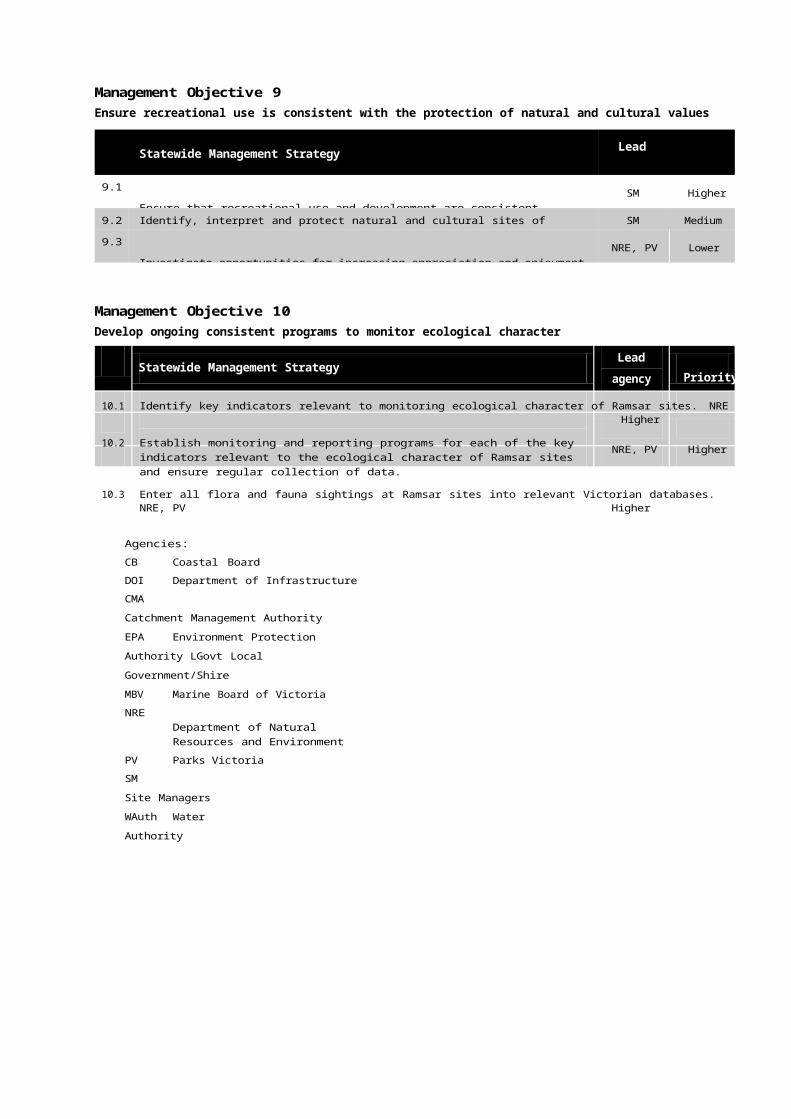
exte
nt
STRATEGIC DIRECTIONS STATEMENT FOR MANAGEMENT OF VICTORIA'S RAMSAR WETLANDS PAGE 47
the ranking process is concerned with presence/absence of a risk-value relationship and the number of values impacted upon. This further highlights the need to reach consensus on the previous step, particularly in terms of relating risks to values.
3.4 Analyse extent
This step in the process estimates the likely extent of the risk by drawing on information accumulated on the risk's "behaviour", and extent of occurrence in similar events. For this exercise, we need to consider both current extent and past trends of extent. In the case of an invasive weed, information might include detailed information on its entry into an ecosystem, rate of spread, and preferential habitat.
While field surveys represent the ideal approach, use of historical records, simulation modelling, or field and/or laboratory-based experimental studies are acceptable methods of characterising the extent of a given risk.
3.4.1 Assign a score to extent
Evaluate each risk with regard to its current coverage of a particular site (i.e. its extent). The extent of a risk is determined on the basis of local knowledge supported by professional judgement and any relevant literature. Ideally, the extent of a risk should be expressed as a percentage of the total area in order to allow comparison with other risks. In many cases (e.g. point source risks) this is not possible, but an attempt should be made to quantify the problem (e.g. number of nodes).
The percentage of total area affected should then be expressed as a relative score of high, medium and low. The thresholds for high, medium and low scores will be determined by the nature of the risk. This determination will ideally be based on actual
(i.e. quantified or objective) supplemented by perceived (i.e. qualified or subjective) information.
3.4.2 Assign a score to the trend of extent
To gain a more thorough appreciation of a risk, it is important to understand its behaviour in an historical context. The best way to achieve this is to review documentation on the presence and behaviour of a particular risk at the site or at a site with similar characteristics. If this information is not readily available, then it is adequate to substitute a best approximation, as the end result is a general and relative indication of trend.
Assign an appropriate timeframe to the trend analysis. In most situations this will be a continuous period from the introduction of a risk to a value, to the present. In other cases, such as land clearing (which may have commenced as an activity more than 150 years ago), professional judgement should be exercised to denote when the activity first had a recognisable influence on values.
Evaluate any trends in the extent of the risk as progression over an appropriate timeframe. In most cases: increased extent = high; static or relatively constant extent = medium; and decreasing extent = low. In some cases, the extent of a risk may have fluctuated over time. If this is the case, then it is reasonable to consider the average trend using a "line of best fit", and allocate a score on that basis.
To illustrate the relationship between extent and trend, use a two-axis graph with vertical axis as extent, and horizontal axis as trend (extent). In figure 3 below, the blue line could represent a high but stable population of rabbits, whereas the green line could represent the incursion of an exotic weed species that is presently contained as a result of ongoing management control.
Figure 3 - Graph of extent versus trend of extent
h
m
m htrend (extent)

STRATEGIC DIRECTIONS STATEMENT FOR MANAGEMENT OF VICTORIA'S RAMSAR WETLANDS PAGE 48
impa
ct
3.5 Analyse impact (current and past trends)
The aim of this step is to weigh up each value-risk relationship, estimate adverse impacts (prospective), and evaluate the likelihood that impacts are caused by exposure to past stressors (retrospective). A combination of retro- and prospective factors is particularly useful where ecosystems have a history of exposure and can be used to predict the effect of future management actions, including the consequences of taking no action.
In many cases the relationship between a risk and the value/s it impacts on is poorly understood. To gain an understanding of the impact of a risk to a value, it may be necessary to draw comparisons to other sites with similar characteristics. If this is not possible, the default is to call upon professional judgement or qualitative statements, so long as there is broad agreement on the issue.
Assessment of impact must take into account both the potential and consequence of an action or occurrence. For example, the potential for oil spills is relatively small. However, the consequences of an oil spill are severe, and therefore need to be seriously considered and appropriately managed. Risk minimisation techniques established by policy and/or legislation play an important role but are by no means comprehensive. A generally accepted method for managing oil spills, should they occur, is to ensure that sufficient oil spill contingencies are developed and implemented as a precautionary measure.
3.5.1 Assign a score to the impact
Allocate a high, medium or low score to the current impact of a risk on a single value, or set of values.
3.5.2 Assign a score to the trend of impact
If the impact has increased over the identified timeframe, then score as high. If the effect is negligible, score it as low. If the impact has remained constant, or if it has varied between high and low, allocate a medium score.
To illustrate the relationship between current impact and past trends of impact, develop a two dimensional graph with effect on the vertical and trend of effect on the horizontal axis (see Figure 4).
3.6 Risk characterisation
Risk characterisation is an estimation of the likely level of adverse ecological change on the wetland system, and takes into account extent, impact, and past trends. This is achieved by integrating the results from the assessment of the extent of the problem, with the results from the assessment of the actual and/or likely impact. The end result of the risk characterisation will be a clear statement on the degree of impact on a particular value that is likely to result from a given risk.
A range of techniques exists for estimating risks, often depending on the type and quality of the likely impacts and their extent. A useful technique for characterising risks in wetlands is the establishment of a GIS-based framework, whereby the results of the various assessments are overlaid onto a map of the region of interest in order to link extent and effect to impact. In addition to estimating risks, this exercise serves to focus future assessments and/or monitoring in relation to identified risk areas.
Figure 4 - Graph of impact, and trend of impact
h
m
m htrend (impact)

STRATEGIC DIRECTIONS STATEMENT FOR MANAGEMENT OF VICTORIA'S RAMSAR WETLANDS PAGE 49
3.6.1 Risk profile
The risk profile involves an evaluation of available data to determine the likelihood and magnitude of adverse change or impact on the wetland. It is preferable that these data are derived from field studies, as this information is more appropriate for assessments of multiple impacts. Depending on the scale of impact and available resources, studies can range from quantitative field experiments to qualitative observational studies.
For chemical impacts, on-site ecotoxicological bioassays constitute appropriate approaches; whereas for adverse changes resulting from weeds or feral animals, observation and mapping techniques are generally sufficient.
3.6.2 Relative risk
For the strategic risk assessment, relative risk is an expression of the extent, impact and overall trend. To explain this relationship, combine impact/trend (Figure 3) and extent/trend (Figure 4) into a three-dimensional graph with horizontal axis as extent, vertical axis as impact, and a third (or "z" axis) as average trend for both extent and impact (see Figure 5).
3.6.3 Risk rating
To differentiate between risks of high, medium and low priority it is necessary to apply a rating system that generates a combined score for the three factors of extent, impact and average trend. Scores for each factor are allocated as follows: high = 3, medium = 2, and low = 1 (note: not present = 0). The end result will be a total score between 0 and 9. A score of 7 to 9 indicates a high priority; 4 to 6 a medium priority; and less than 4 is a low priority risk.
In cases where the average trend lies between two nodes, the result will be at the midpoint between the two nodes. For example, if the trend for impact is medium and the trend for extent is high, the overall extent will be medium-high.
3.7 Set priorities for risk reduction
Information obtained throughout the strategic risk assessment process will guide decisions that minimise environmental risks, while taking into account socio-economic and environmental values. The Ramsar Convention suggests that risk management must also consider the principles of wise use and the potential effects of management decisions at the catchment level.
Risk management is a multi-disciplinary task that takes into account political, social, economic, and technical factors; and the respective benefits and limitations of each risk-reducing action. Communication between site managers and experts in relevant disciplines is an essential component of successful risk mitigation.
The priorities for management should be based on the combined score of extent, effect and trend (i.e. overall risk). It stands to reason that the reduction or elimination of high risk impacts will result in a high benefit to the identified values. In practical terms the decision on management response will need to consider a wider range of factors including site-specific resource issues. For areas managed by Parks Victoria, the Environmental Management System promotes a hierarchy of management such that actions that result in risk avoidance are given higher priority over (in descending order) risk sharing, risk minimisation and management of residual risk.
Figure 5 - 3-dimensional graph of impact, extent and average trend
trend
m h
h
m
m
extent h

STRATEGIC DIRECTIONS STATEMENT FOR MANAGEMENT OF VICTORIA'S RAMSAR WETLANDS PAGE 50
3.8 Monitoring and evaluation
As a general principle, monitoring should be designed and undertaken to verify the effectiveness of the risk management decisions or actions. It should incorporate measures that function as a reliable early warning system, detecting the failure or poor performance of risk management prior to serious environmental harm occurring. The risk assessment will be of little or no value if effective monitoring is not an integral component of the process.
The selection of measurable endpoints in the monitoring process is critical. Further, a GIS-based approach is the most practical application for wetland risk assessment, as it incorporates a spatial dimension that is useful for both monitoring and predicting adverse impacts on wetland values.
3.8.1 Iteration
Another important consideration in scoping, managing and completing an ecological risk assessment is an appreciation of the iterative nature of the process. Using sequential iterations throughout the process can increase ecological "realism" while decreasing uncertainty. As new information is acquired at each stage, there should be sufficient flexibility to review the original plan and modify the scope of the assessment as required.
4 Conclusion
The strategic risk assessment process does not propose management actions, nor does it attempt to pre-determine suitability of management actions to addressing certain risks. The strategic risk assessment does, however, provide a transparent and repeatable process for assigning strategic priorities. Evaluating and selecting proposed management actions based on efficacy and available resources is a separate issue and should be undertaken as a subsequent exercise, based on the outcome of the strategic risk assessment.
As a general rule, if a particular risk is a high priority concern in a strategic sense, then an associated management action will be afforded the same level of priority. However, in many cases, high priority risks may not be addressed in the short or long term due to the complexity of the issue, political processes, or insufficient resources. In these circumstances a more detailed analysis of the impediments can be identified as a potential management action in its own right.
Generating management solutions at the site level inherently involves an understanding of previous management techniques but should not preclude consideration of untried methods. In practical terms, preference will generally be given to methods that are tried and proven as opposed to experimental management techniques that are poorly documented. In any event, management actions will be developed and selected in terms of their ability, known or perceived, to address risk.
At the site level, it may be necessary to repeat the strategic risk assessment procedure for the defined set of high priority actions. This will result in a greater level of detail for decision making and allocating resources to management priorities.
5 References
USEPA (1998) Guidelines for Ecological Risk Assessment
Convention on Wetlands (1999) Wetland Risk Assessment Framework, Resolution 7.10 of the seventh Meeting of the Contracting Parties to the Convention on Wetlands, Costa Rica.


![untitled [parkweb.vic.gov.au]parkweb.vic.gov.au/__data/assets/word_doc/0003/... · Web viewThe MCMC has a long history in advocacy and on‐ground works for the protection and enhancement](https://img.pdfslide.us/doc/110x75/5a718b767f8b9a98538cff18/untitled-parkwebvicgovauparkwebvicgovaudataassetsworddoc0003doc.jpg)