Embed Size (px)
Citation preview
1 23
Geoheritage ISSN 1867-2477 GeoheritageDOI 10.1007/s12371-017-0232-5
Araripe Basin: A Major GeodiversityHotspot in Brazil
François Bétard, Jean-Pierre Peulvast,Alexsandra de Oliveira Magalhães, Mariade Lourdes Carvalho Neta & FranciscoIdalecio de Freitas
1 23
Your article is protected by copyright and all
rights are held exclusively by The European
Association for Conservation of the Geological
Heritage. This e-offprint is for personal
use only and shall not be self-archived
in electronic repositories. If you wish to
self-archive your article, please use the
accepted manuscript version for posting on
your own website. You may further deposit
the accepted manuscript version in any
repository, provided it is only made publicly
available 12 months after official publication
or later and provided acknowledgement is
given to the original source of publication
and a link is inserted to the published article
on Springer's website. The link must be
accompanied by the following text: "The final
publication is available at link.springer.com”.
ORIGINAL ARTICLE
Araripe Basin: A Major Geodiversity Hotspot in Brazil
François Bétard1& Jean-Pierre Peulvast2 & Alexsandra de Oliveira Magalhães3 &
Maria de Lourdes Carvalho Neta3 & Francisco Idalecio de Freitas4
Received: 28 September 2016 /Accepted: 3 May 2017# The European Association for Conservation of the Geological Heritage 2017
Abstract In addition to a Fossil-Lagerstätte of international sig-nificance for the Lower Cretaceous, the Araripe basin is one ofthe richest and most threatened reservoirs of geodiversity inBrazil. Far from being limited to its palaeontological heritage,themajor importance of geodiversity in the Araripe region is alsorelated to high levels of geomorphodiversity, pedodiversity, andhydrodiversity, as evidenced by recent research. However, nu-merous threats and severe damages were identified in the field,affecting all the components of the abiotic nature. As a majorgeodiversity hotspot, the Araripe basin requires greater attentionalong with an urgent need for conservation in areas withoutadapted protection tools. The creation of the Araripe UNESCO
Global Geopark in 2006 was a crucial step toward geodiversityconservation, but its present borders are far from covering theAraripe basin as a whole. This implies the search for new solu-tions or alternatives, mainly in the field of geoeducation, to raisegeodiversity awareness among the municipal authorities as wellas the local population, in a predominantly rural region todayaffected by rapid and poorly planned urban growth.
Keywords Geodiversity . Geomorphodiversity .
Pedodiversity . Hydrodiversity . Geopark . Araripe . Brazil
Introduction
Situated at the border between the states of Ceará, Pernambuco,and Piauí (northeastern Brazil), the Araripe basin is world fa-mous for its palaeontological heritage that exhibits abundantand diverse fossil records of Early Cretaceous age (Martill et al.2007), promoting a part of the basin as the first UNESCOGeopark of the Americas and the Southern Hemisphere(Araripe Geopark; Herzog et al. 2008). Its worldwide recognitionis mainly due to the exceptional state of preservation of faunaland floral fossil assemblages occurring in the Crato andRomualdo members of the Santana Formation (108–92 Myr), astratigraphic unit internationally designated as a ConservationLagerstätte of high significance for the Lower Cretaceous(Martill 1993, 2007). Such a rich palaeontological heritage andassociated palaeobiodiversity makes the Araripe basin a highplace of Brazilian geodiversity (Silva 2008). However, recentstudies on landforms, soils, and landscape evolution of theAraripe basin and surroundings (Bétard et al. 2005; Magalhãeset al. 2010; Peulvast et al. 2011; Peulvast and Bétard 2015a,2015b) have revealed that the regional geodiversity is far frombeing limited to its palaeontological portion. According to thecommonly used definition by Gray (2013), geodiversity
* François Bé[email protected]
Jean-Pierre [email protected]
Alexsandra de Oliveira Magalhã[email protected]
Maria de Lourdes Carvalho [email protected]
Francisco Idalecio de [email protected]
1 Université Paris-Diderot, UMR CNRS 8586 PRODIG, case courrier7001, 75205 Paris cedex 13, France
2 Université Paris-Sorbonne, 191 rue Saint-Jacques,75005 Paris, France
3 Universidade Regional do Cariri (URCA), Laboratório de AnáliseGeoambiental, LAGEO, Rua Coronel Antônio Luiz 1161,Crato, Ceará 63105-000, Brazil
4 Araripe UNESCOGlobal Geopark, Carolino Sucupira, s/n - Pimenta,Crato, Ceará 63105-000, Brazil
GeoheritageDOI 10.1007/s12371-017-0232-5
Author's personal copy
encompasses Bthe natural range (diversity) of geological (rocks,minerals, fossils), geomorphological (landforms, topography,physical processes), soil and hydrological features,^ thus extend-ing the geodiversity concept to the whole abiotic nature. In fact,the great diversity of landforms (morphostructural patterns,palaeolandforms, landslide deposits and processes…), soils (di-versity of pedotaxa, palaeosoils, and pedogenic processes), andhydrological features (karstic springs, waterfalls, etc.) contributeto the high geodiversity of the Araripe region, both intrinsicallyand extrinsically.
Considering the numerous threats that today affectgeodiversity in this developing region, and as a parallel tobiodiversity hotspots (Myers et al. 2000), we consider in thispaper the Araripe basin as a major Bgeodiversity hotspot^ at aglobal scale—i.e., a geographic area that harbors very highlevels of geodiversity while being threatened by human activ-ities (Bétard 2016). The different threats identified in the areado not only affect the palaeontological heritage (Vilas-Boaset al. 2012), but all the elements of geodiversity (e.g., land-forms, soils, and waters), and makes necessary to carry out anintegrated assessment of geodiversity and a precise identifica-tion of the threats that endanger it, for a further integration intogeoconservation strategies. With these issues and challengesin mind, the aims of this paper are (1) to reevaluate thegeodiversity in the Araripe basin beyond the perimeter of theGeopark by taking into account all the components of abioticnature, in the light of recent geomorphological, pedological,and hydrological data; and (2) to identify the current and po-tential threats to regional geodiversity and to propose sustain-able solutions adapted to the economic and socio-educationalcontext of interior northeast Brazil.
The Araripe Basin: AWorld Geoheritage Area
Geographical and Geological Setting
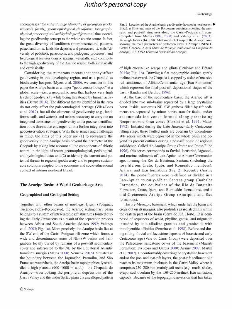
Together with other basins of northeast Brazil (Potiguar,Tucano–Jatobá–Reconcavo), the Araripe sedimentary basinbelongs to a system of intracratonic rift structures formed dur-ing the Early Cretaceous as a result of the separation processbetween Africa and South America (Matos 1992; Valençaet al. 2003; Fig. 1a). More precisely, the Araripe basin lies atthe SW end of the Cariri–Potiguar rift zone which forms awide and discontinuous series of NE–SW basins and half-grabens locally buried by remains of a post-rift sedimentarycover and intersected to the NE by the Equatorial Atlantictransform margin (Matos 2000; Nemčok 2016). Situated atthe boundary between the Jaguaribe, Parnaíba, and SãoFranciscowatersheds, the Araripe basin topographically strad-dles a high plateau (900–1000 m a.s.l.)—the Chapada doAraripe—overlooking the peripheral depressions of theCariri Valley and the wider Sertão plain via a scalloped pattern
of high cuesta-like scarps and glints (Peulvast and Bétard2015a; Fig. 1b). Drawing a flat topographic surface gentlyinclinedwestward, the Chapada is capped by a slab ofmassivered sandstones of Albian/Cenomanian age (Exu Formation)which represent the final post-rift depositional stages of thebasin (Baudin and Berthou 1996).
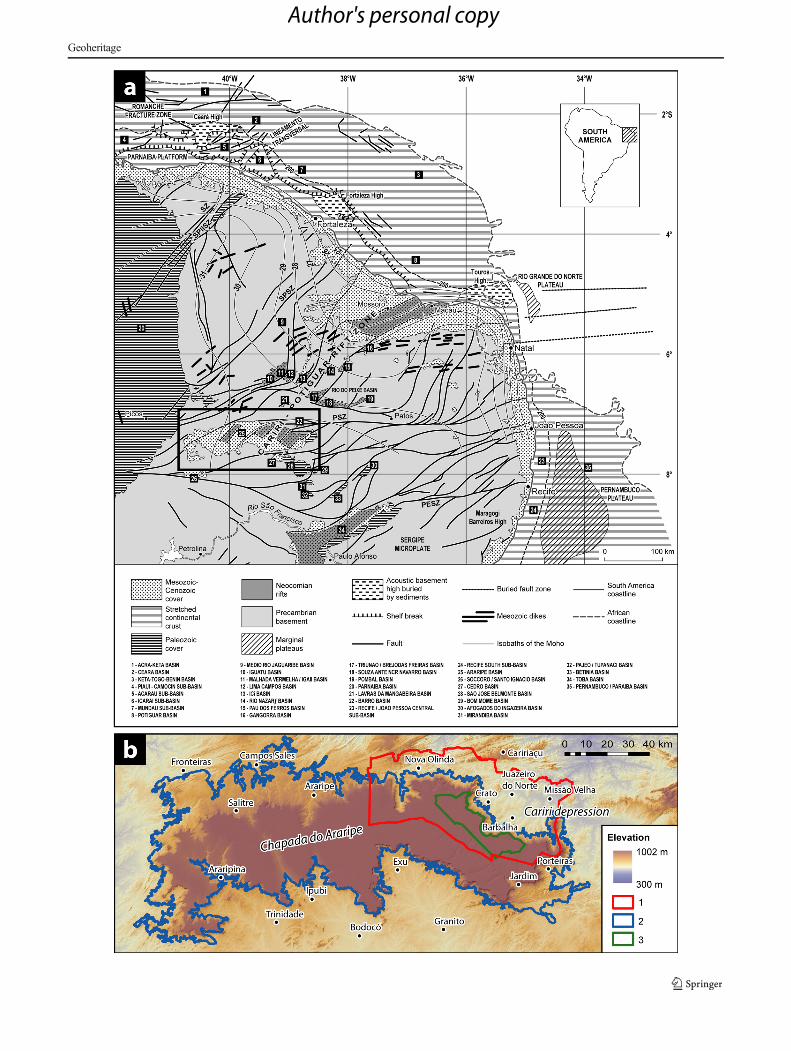
At the base of the sedimentary basin, the Araripe rift isdivided into two sub-basins separated by a large crystallinehorst. Inside, numerous NE–SW grabens filled by rift sedi-ments are separated by minor horsts, transfer faults, and/oraccommodat ion zones formed along preexis t ingNeoproterozoic shear zones (Corsini et al. 1991; Matos1992). Initiated during the Late Jurassic–Early Cretaceousrifting stage, these faulted units are overlain by unconform-able series which were deposited in the whole basin and be-yond its present outlines during a post-rift phase of regionalsubsidence. Called the Araripe Group (Ponte and Ponte-Filho1996), this series corresponds to fluvial, lacustrine, lagoonal,and marine sediments of Late Aptian to Albian/Cenomanianage, forming the Rio da Batateira, Santana (including thefossiliferous Crato, Ipubi, and Romualdo members),Arajara, and Exu formations (Fig. 2). Recently (Assine2014), the post-rift series were re-defined as divided in aLate-Aptian to early-Albian Santana group (BarbalhaFormation, the equivalent of the Rio da BatateiraFormation, Crato, Ipubi, and Romualdo formations), and amid-Cretaceous Araripe Group (Araripina and Exuformations).
The pre-Mesozoic basement, which underlies the basin andcrops out on its margins, also protrudes as isolated hills withinthe eastern part of the basin (Serra de Juá, Horto). It is com-posed of sequences of schist, phyllite, gneiss, and migmatiteintruded by calc-alkaline granites and granitoids withtrondhjemitic affinities (Ferreira et al. 1998). Before and dur-ing rifting, fluvial and lacustrine deposits of Jurassic and earlyCretaceous age (Vale do Cariri Group) were deposited overthe Palaeozoic sandstone cover of the basement (MauritiFormation; Da Rosa and Garcia 2000; Assine 2007; Martillet al. 2007). Unconformably covering the crystalline basementand/or the pre- and syn-rift layers, the post-rift sediment pilereaches its maximum thickness in the Cariri Valley where itcomprises 250–280m ofmainly soft rocks (e.g., marls, shales,evaporites) overlain by the 150–250-m-thick Exu sandstonecaprock. Because of the topographic inversion that has taken
�Fig. 1 Location of the Araripe basin geodiversity hotspot in northeasternBrazil. a Structural map of the Borborema province, showing the pre-,syn-, and post-rift structures along the Cariri–Potiguar rift zone.Compiled from Matos (1992, 2000) and Valença et al. (2003).Rectangle locates (b). b SRTM-derived relief map of the Araripe basin,showing the main perimeters of protection areas. 1 Araripe UNESCOGlobal Geopark, 2 APA (Área de Proteção Ambiental da Chapada doAraripe), 3 FLONA (Floresta Nacional do Araripe)
Geoheritage
Author's personal copy
Geoheritage
Author's personal copy
place since the Late Cretaceous in response to large-scaleflexural uplift (Peulvast et al. 2008; Peulvast and Bétard2015a), the former basin floor now forms the plateau surface(or Chapada) as a direct result of differential erosion owing tothe mechanical resistance of the Exu sandstones and to theirhigh permeability which prevents them from deep erosion anddissection. Such a complex geological setting is particularlyprone to high geodiversity, with some elements of high con-servation or heritage values.
From Geodiversity to Geoheritage: The AraripeUNESCO Global Geopark
Whereas geodiversity refers to the variety of abiotic nature(Gray 2013), geoheritage is the set of the most relevantgeodiversity elements with particular importance for science,education, or tourism (Pereira et al. 2012). In the study area,the societal recognition of geodiversity elements asgeoheritage was favored inside the perimeter of the Araripe
Fig. 2 Simplified geological map and cross-section of the Araripe basin.aMapmodified from Ponte and Ponte-Filho (1996) and Assine (1994). 1Exu Formation; 2 Arajara, Santana, Rio da Batateira formations; 3Araripe Group; 4 Cariri Group; 5 Mauriti Formation; 6 basementcomplex; 7 fault; 8 lineament; 9 state border. b Geological profilethrough the Crato area, modified from Ponte and Ponte-Filho (1996). 1
Precambrian basement; 2 pre-Phanerozoic unconformity; 3 Silurian/Devonian: post-orogenic tectono-sequence; 4 pre-Mesozoicunconformity; 5 Late-Jurassic-Early Cretaceous: pre- and syn-rifttectono-sequence (undivided); 6 Pre-Aptian unconformity; 7 post-rifttectono-sequence (a Rio da Batateira Formation; b Santana, Arajara,and Exu formations)
Geoheritage
Author's personal copy
UNESCO Global Geopark, in the Ceará State, where the fos-siliferous Santana Formation largely outcrops in the scarpsand associated box canyons surrounding the Cariri Valley(Fig. 1b). The Geopark territory (3441 km2) covers the mu-nicipalities of Barbalha, Crato, Juazeiro do Norte, MissãoVelha, Nova Olinda, and Santana do Cariri, and encompassesa fast-growing conurbation of ~450,000 inhabitants (theCrato-Juazeiro do Norte-Barbalha urban area, orCRAJUBAR triangle). The Geopark project was politicallyinitiated by the Government of Ceará State and scientificallycoordinated by the Regional University of Cariri (URCA) inorder to become a member of the Global Geoparks Network(GGN), officially claimed in 2006. Therefore, the AraripeGeopark was the first UNESCO Geopark of the Americancontinent to be included in the GGN. The significance of thenatural heritage of the area and hence its protection is alsodemonstrated by the National Araripe Forest (FLONA), al-ready established in 1946, which protects an isolated area ofAtlantic rainforest (Bétard et al. 2017).
In the Araripe Geopark, geoheritage includes both in situelements (i.e., geosites) and ex situ objects (i.e., museum col-lections). In situ geoheritage is currently represented by a se-lection of 9 geosites—extracted from a first inventory of 59geosites—which were effectively conserved and managed inorder to support geotourism and educational uses (Table 1,Fig. 3). The selection of geosites was primarily made to en-compass the geological diversity of the area and was basedboth on scientific and additional values (e.g., cultural,aesthetic, historical, ecological, etc.; see Mochiutti et al.2012 for a complete analysis of geodiversity values of eachgeosite). Besides the existence of this network of geositesforming the in situ geoheritage, ex situ objects are mainlyrepresented by specimens and fossil collections of thePalaeontological Museum of Santana do Cariri (PMSC) andsmaller public or private museums (Crato, Jardim).With morethan 6000 exhibited specimens, the PMSC houses variouscollections of minerals and fossils (silicified trunks, angio-sperms, ferns, arthropods, fishes, reptiles including pterosaursand dinosaurs…) mainly from the Santana and Missão Velhaformations of the Araripe basin (Fig. 4).
Superimposed Patterns of Geodiversityin the Araripe Basin
Although geodiversity is often equated to geological diver-sity and thus mainly associated with solid rocks and fossils,it can comprise all the abiotic forms, materials, and pro-cesses that constitute the range of non-living nature (sensuGray 2013). In that sense, we propose a qualitative reap-praisal of geodiversity in the Araripe basin, well beyondthe present boundaries of the Geopark, by examining suc-cessively the diversity of (1) rocks, minerals, and fossilsT
able1
Listo
fgeositesin
theAraripe
UNESCOGlobalG
eopark
Num
ber
Geosite
Municipality
Scientificvalue
Additionalvalues
1Colinado
Horto
Juazeiro
doNorte
Petrography
(granites,diorites)andgeom
orphology
(exhum
edpalaeoreliefwith
panoramicview
abovetheCaririV
alley)
Culturalv
alue
ofrelig
ious
concerns
(Christianpilgrimagesite,
with
theCíceroPrieststatue
andmuseum)
2Cachoeira
deMissãoVelha
MissãoVelha
Hydrology
(spectacular
waterfallof
12m
high)andstratigraphy
(Silurian/Devoniansandstones
oftheMauritiFo
rmation)
Culturalv
alue
associated
with
anim
portantarchaeological
siteexhibitingprehistoricalp
aintings
(BLetreiroStone^)
3FlorestaPetrificadado
Cariri
MissãoVelha
Palaeontology
(petrified
forest—silicifiedtrunks
ofconifers
from
theMissãoVelha
Formation)
andgeom
orphology
(badlands)
Educatio
nalv
alue
(schoolv
isits
forenvironm
entaleducation
with
outdooractivities)
4Batateiras
Crato
Palaeontology
(bitu
minousclaysrich
infossils—ostracods,
plants,algae,fishes…
)andhydrology(w
aterfalls)
Cultural(KaririIndianlegends)andecological
values
(BParque
EstadualS
ítioFu
ndão^)
5Pedrado
Cariri
NovaOlin
daPalaeontology
(fossiliferouslaminated
limestone
from
theCrato
Mem
berof
theSantanaFo
rmation—
insects,fishes…)
Educatio
nalv
alue
(schoolv
isits
forenvironm
entaleducation
with
outdooractivities)
6Parque
dosPterossauros
NovaOlinda
Palaeontology
(fossiliferouscarbonateconcretio
nsfrom
the
Rom
ualdoMem
berof
theSantanaFo
rmation—
fishes,pterosaurs…
)Educatio
nalv
alue
(schoolv
isits
forenvironm
entaleducation
with
outdooractivities)
7Riachodo
Meio
Barbalha
Hydrology
(karsticsprings)andstratig
raphy(contactbetween
theExu
andArajara
form
ations)
Ecologicalv
alue
(BParque
Ecológico^—
remnantsof
Atlantic
rainforestwith
someendemicspecies)
8Po
ntede
Pedra
NovaOlinda
Geomorphology(sandstone
arch
aboveanarrow
canyon
carved
byfluvialp
rocesses
into
theExu
Formation)
Culturalv
alue
(KaririIndianlegends,prehistoricalp
aintings—
Olhod’Aguaarchaeologicalsite)
9Po
ntalda
SantaCruz
Santanado
Cariri
Geomorphology(naturalbelvedereon
theExu
sandstonecornice
abovetheSantanado
Caririb
oxcanyon)
Cultural(chapelSãoBom
JesusdasOliveiras)andecological
values
(botanicaltrail)
Geoheritage
Author's personal copy
(i.e., geological diversity); (2) landforms and processes (i.e.,geomorphodiversity); (3) soils and processes (i.e.,pedodiversity); and (4) surface and groundwaters (i.e.,hydrodiversity). Both components are regarded in intrinsic(i.e., complexity inside the study area) and extrinsic ways(i.e., compared with other areas). Figure 5 provides a syn-optic view of the Araripe basin according to the four maincomponents of geodiversity.
Geological Diversity
Geological diversity (sensu stricto) addresses the variationof rocks, minerals, and fossils, including their complex as-semblages and the geological processes that shape them(Gray 2013). Petrographically, the three rock categories ofthe Earth’s crust are represented in the Araripe region: igne-ous, metamorphic, and sedimentary. Plutonic and metamor-phic rocks form the crystalline basement at the base andperiphery of the sedimentary basin (GU1—Fig. 5). Whenexposed, this basement of Proterozoic–Paleozoic age ap-pears as a complex assemblage of metasedimentary (schists,
phyllites, quartzites, paragneisses…), metaplutonic(orthogneisses, amphibolites), and metavolcanic rocks(metabasalts, Bgreen belt^ rocks) intruded by syn- andpost-tectonic granitoids of varied compositions (granitic,dioritic, tonalitic, trondhjemitic…; CPRM 2001, 2003).All these rocks are affected by intense deformations (fold-ing and/or faulting) with mylonitic and migmatitic faciesalong major Neoproterozoic shear zones as, for example,along the EW trending Patos dextral shear zone that fringesthe basin to the North (Santos et al. 2008; Neves 2015).Inside the Araripe basin, a wide range of sedimentary rocksform the successive, mainly horizontal strata of the pre-,syn-, and post-rift units, ranging from the Silurian/Devonian (Mauriti Formation) to the Albian/Cenomanian(Exu Formation), with several hiatus and unconformities(Ponte and Ponte-Filho 1996; Assine 2007; Fig. 2).Sandstones and conglomerates (silificied or not) are thedominant rock types of the basin, with numerous intercala-tions of limestones, marls, evaporites, shales, and siltstones(e.g., GU6—Fig. 5). Such a lithological complexity contrib-utes to high intrinsic geodiversity.
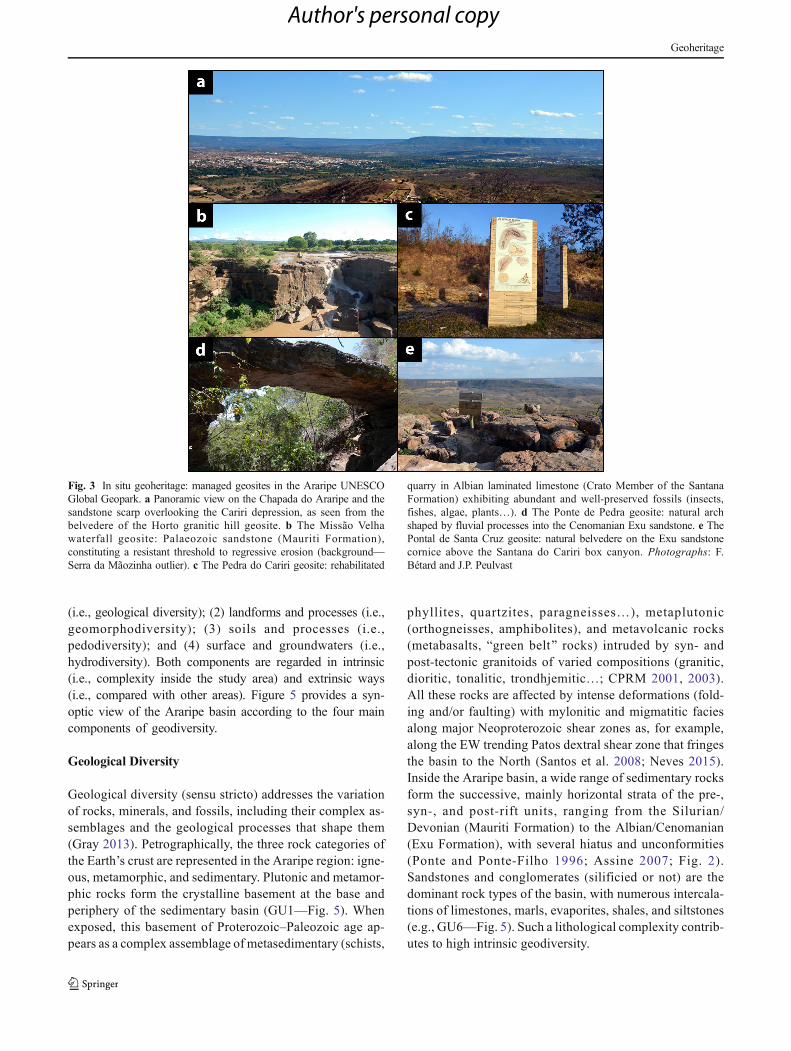
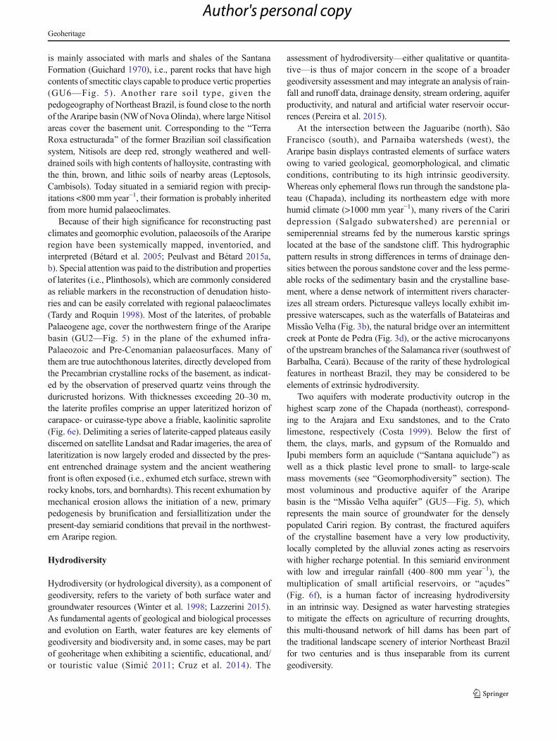
Fig. 3 In situ geoheritage: managed geosites in the Araripe UNESCOGlobal Geopark. a Panoramic view on the Chapada do Araripe and thesandstone scarp overlooking the Cariri depression, as seen from thebelvedere of the Horto granitic hill geosite. b The Missão Velhawaterfall geosite: Palaeozoic sandstone (Mauriti Formation),constituting a resistant threshold to regressive erosion (background—Serra da Mãozinha outlier). c The Pedra do Cariri geosite: rehabilitated
quarry in Albian laminated limestone (Crato Member of the SantanaFormation) exhibiting abundant and well-preserved fossils (insects,fishes, algae, plants…). d The Ponte de Pedra geosite: natural archshaped by fluvial processes into the Cenomanian Exu sandstone. e ThePontal de Santa Cruz geosite: natural belvedere on the Exu sandstonecornice above the Santana do Cariri box canyon. Photographs: F.Bétard and J.P. Peulvast
Geoheritage
Author's personal copy

A huge diversity of minerals characterizes the com-plex geological environment of the Araripe region, cor-responding to various contexts of formation by a widevariety of mineralization processes: magma cooling,low- to high-grade metamorphism, hydrothermal precip-itation, supergene weathering, evaporation of saline wa-ter, transport sorting by erosional agents, chemical pre-cipitation in oxic and anoxic waters, etc. The crystallinebasement exhibits the highest richness of gemstones dueto its great petrological heterogeneity which also partic-ipates in the high intrinsic geodiversity of the Arariperegion: amethyst, baryte, beryl, rock crystal, garnet,gold, pyrite, rutile, tourmaline… (GU1—Fig. 5). Arange of mineral occurrences is also referenced on geo-logical maps (CPRM 2001, 2003) in the sedimentaryunits of the basin because of their economic exploitationfor artisanal or industrial uses (iron ores, kaolinite,montmorillonite, calcite, gypsum…).
Last but not least, many rocks of the Araripe sedimentarybasin include fossils that provide direct evidence of ancientlife and past environments of high significance for the history
of the Earth. These have led to the worldwide recognition ofthis region of interior Northeast Brazil among geologists andpalaeontologists (Martill 1993, 2007). In the Araripe basin,the high palaeontological diversity (or palaeobiodiversity) iswell illustrated by the ~6000 specimens exposed in thePalaeontological Museum of Santana do Cariri (Fig. 4) as wellas in smaller public or private museums inside and outside theUNESCO Geopark. Many fossil species are unique orBendemic^ to the Araripe basin with no equivalent elsewhere(Carvalho et al. 2015), contributing to its high extrinsicgeodiversity. Most of the fossil record comes from the Cratoand Romualdo members of the Santana Formation KonservatLagerstätte (GU6—Fig. 5). The limestone fossil beds of theCrato Member show exceptional states of preservation forentomofauna (>200 species of insects) and flora (>50 speciesof plants) of high significance for the development of angio-sperm in the Lower Cretaceous, whereas the RomualdoMember contains carbonate concretions with very diverseand well-preserved fossils of fishes (22 species), reptiles (in-cluding dinosaurs and 23 species of pterosaurs), invertebrates,and plants (Schobbenhaus et al. 2002; Martill et al. 2007). The
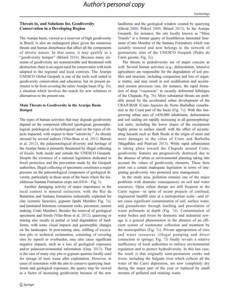
Fig. 4 Ex situ geoheritage: fossil collections from the PalaeontologicalMuseum of Santana do Cariri (PMSC). a The PMSC (outdoor), one of themost comprehensive collections of Lower Cretaceous fossils in the world.b Silicified trunks of conifers from the Missão Velha Formation,collection PMSC. c Fossil plants (Brachyphyllum obesum Heer, 1881)from the Crato Member of the Santana Formation, collection PMSC. dFossil dragonfly (Cordulagomphus fenestratus Carle & Wighton, 1990)
from the Crato Member of the Santana Formation, collection PMSC. eFossil fish (Araripelepidotes temnurus (Agassiz, 1841)) from theRomualdo Member of the Santana Formation, collection PMSC. fPterosaur skeleton (Family: Anhanguaridae) from the RomualdoMember of the Santana Formation, collection PMSC. Photographs: F.Bétard
Geoheritage
Author's personal copy
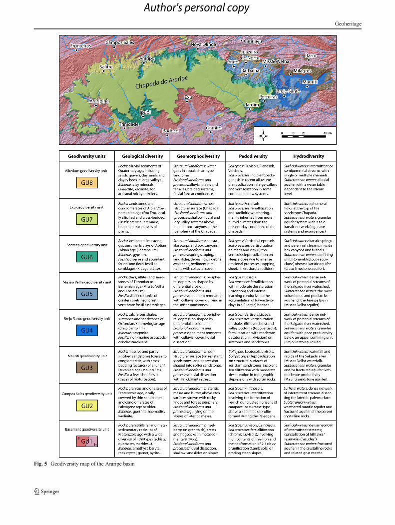
Fig. 5 Geodiversity map of the Araripe basin
Geoheritage
Author's personal copy
fossiliferous Santana Formation largely outcrops in the CearáState, inside the Geopark (to the northeast), as well as in thePernambuco and Piauí States, outside the Geopark (to thesouth and west—Fig. 5; Barreto et al. 2012). Other geologicalformations also part icipate in the high levels ofpalaeontological diversity of the Araripe basin, particularlythe Missão Velha Formation with its petrified forest (Herzoget al. 2008; GU5—Fig. 5).
Geomorphodiversity
Accord ing to the def in i t ion by Panizza (2009) ,geomorphodiversity (or geomorphological diversity) is Bacritical and specific assessment of the geomorphological fea-tures of a territory, by comparing them in an extrinsic and inintrinsic way, taking into account the scale of investigation,the purpose of the research and the level of scientific quality.^As a subset of the wider concept of geodiversity, geomorphicfeatures contribute to the high levels of geodiversity of theAraripe basin at various scales, as highlighted by recent geo-morphological works (Magalhães et al. 2010; Peulvast et al.2011; Peulvast and Bétard 2015a, b).
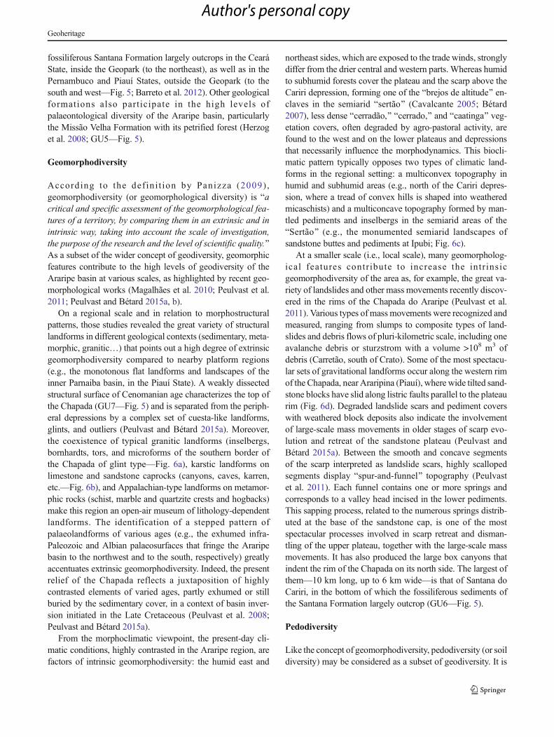
On a regional scale and in relation to morphostructuralpatterns, those studies revealed the great variety of structurallandforms in different geological contexts (sedimentary, meta-morphic, granitic…) that points out a high degree of extrinsicgeomorphodiversity compared to nearby platform regions(e.g., the monotonous flat landforms and landscapes of theinner Parnaiba basin, in the Piauí State). A weakly dissectedstructural surface of Cenomanian age characterizes the top ofthe Chapada (GU7—Fig. 5) and is separated from the periph-eral depressions by a complex set of cuesta-like landforms,glints, and outliers (Peulvast and Bétard 2015a). Moreover,the coexistence of typical granitic landforms (inselbergs,bornhardts, tors, and microforms of the southern border ofthe Chapada of glint type—Fig. 6a), karstic landforms onlimestone and sandstone caprocks (canyons, caves, karren,etc.—Fig. 6b), and Appalachian-type landforms on metamor-phic rocks (schist, marble and quartzite crests and hogbacks)make this region an open-air museum of lithology-dependentlandforms. The identification of a stepped pattern ofpalaeolandforms of various ages (e.g., the exhumed infra-Paleozoic and Albian palaeosurfaces that fringe the Araripebasin to the northwest and to the south, respectively) greatlyaccentuates extrinsic geomorphodiversity. Indeed, the presentrelief of the Chapada reflects a juxtaposition of highlycontrasted elements of varied ages, partly exhumed or stillburied by the sedimentary cover, in a context of basin inver-sion initiated in the Late Cretaceous (Peulvast et al. 2008;Peulvast and Bétard 2015a).
From the morphoclimatic viewpoint, the present-day cli-matic conditions, highly contrasted in the Araripe region, arefactors of intrinsic geomorphodiversity: the humid east and
northeast sides, which are exposed to the trade winds, stronglydiffer from the drier central and western parts. Whereas humidto subhumid forests cover the plateau and the scarp above theCariri depression, forming one of the Bbrejos de altitude^ en-claves in the semiarid Bsertão^ (Cavalcante 2005; Bétard2007), less dense Bcerradão,^ Bcerrado,^ and Bcaatinga^ veg-etation covers, often degraded by agro-pastoral activity, arefound to the west and on the lower plateaus and depressionsthat necessarily influence the morphodynamics. This biocli-matic pattern typically opposes two types of climatic land-forms in the regional setting: a multiconvex topography inhumid and subhumid areas (e.g., north of the Cariri depres-sion, where a tread of convex hills is shaped into weatheredmicaschists) and a multiconcave topography formed by man-tled pediments and inselbergs in the semiarid areas of theBSertão^ (e.g., the monumented semiarid landscapes ofsandstone buttes and pediments at Ipubi; Fig. 6c).
At a smaller scale (i.e., local scale), many geomorpholog-ical features contr ibute to increase the intr insicgeomorphodiversity of the area as, for example, the great va-riety of landslides and other mass movements recently discov-ered in the rims of the Chapada do Araripe (Peulvast et al.2011). Various types of mass movements were recognized andmeasured, ranging from slumps to composite types of land-slides and debris flows of pluri-kilometric scale, including oneavalanche debris or sturzstrom with a volume >108 m3 ofdebris (Carretão, south of Crato). Some of the most spectacu-lar sets of gravitational landforms occur along the western rimof the Chapada, near Araripina (Piauí), where wide tilted sand-stone blocks have slid along listric faults parallel to the plateaurim (Fig. 6d). Degraded landslide scars and pediment coverswith weathered block deposits also indicate the involvementof large-scale mass movements in older stages of scarp evo-lution and retreat of the sandstone plateau (Peulvast andBétard 2015a). Between the smooth and concave segmentsof the scarp interpreted as landslide scars, highly scallopedsegments display Bspur-and-funnel^ topography (Peulvastet al. 2011). Each funnel contains one or more springs andcorresponds to a valley head incised in the lower pediments.This sapping process, related to the numerous springs distrib-uted at the base of the sandstone cap, is one of the mostspectacular processes involved in scarp retreat and disman-tling of the upper plateau, together with the large-scale massmovements. It has also produced the large box canyons thatindent the rim of the Chapada on its north side. The largest ofthem—10 km long, up to 6 km wide—is that of Santana doCariri, in the bottom of which the fossiliferous sediments ofthe Santana Formation largely outcrop (GU6—Fig. 5).
Pedodiversity
Like the concept of geomorphodiversity, pedodiversity (or soildiversity) may be considered as a subset of geodiversity. It is
Geoheritage
Author's personal copy
conceptually defined as Ban inventory of the various discretepedological entities (e.g. soil taxa) and the analysis of theirspatial and temporal patterns^ (Ibáñez et al. 2012). The tem-poral dimensionmeans that it implicitly includes the inventoryof pedological legacies (i.e., palaeosoils) of past climates andthe pedogenic processes that originate them.
Soil diversity estimates can be based on existing soil mapsand surveys over the region (Guichard 1970; ProjetoRadambrasil 1981; IPECE 2007). According to the WorldReference Base soil classification system (IUSS WorkingGroup WRB 2015), 14 pedotaxa at the Reference SoilGroup level are represented in the Araripe region:Arenosols, Anthrosols, Cambisols, Ferralsols, Fluvisols,Leptosols, Lixisols, Luvisols, Nitisols, Planosols,Plinthosols, Regosols, Technosols, and Vertisols.Pedodiversity values are logically much higher if the hierar-chical level used in the reference taxonomy integrates one ormore Bqualifiers^ (e.g., Rhodic Lixisol). Such a huge diversityof soil properties reflects a wide variety of pedogenic process-es acting in the different geological, geomorphological, andbioclimatic settings that characterize the Araripe basin and
surroundings (see sections above). Whereas ferrallitic pedo-genesis prevails on the highly weathered sandstone plateauunder conditions of humid climates, an original pathway offersiallitic pedogenesis, which involves high contents of Bfreeiron^ and the prevalence of 2:1 clays in the soil mineral as-semblage, typifies the wash divides on the crystalline, semiar-id piedmont (Bétard 2007). In the regional setting, the redfersiallitic soils (i.e., Chromic Luvisols) typically formedabove shallow, grus-type weathering mantles developed fromcrystalline parent rocks, under pedoclimatic conditions of low,but irregular, deep drainage (Bétard 2012). They are very dif-ferent from the ferrallitic and ferruginous soils (Ferralsols,Acrisols, and Lixisols) which cover large tracts of tropicalAmerica and Africa. In that sense, such soils, quite rare intropical environments, are factors of high extrinsicpedodiversity.
On a local scale, other soil types appear as regionally sparsepedotaxa and greatly participate in the high intrinsicpedodiversity. This is particularly the case of Vertisols, whichare surprisingly rare in semiarid Northeast Brazil, whereasthey occupy large areas of the Araripe basin. Their existence
Fig. 6 Relevant geodiversity features of the Araripe basin outside theperimeter of the UNESCO Geopark. a Granitic tor and ruinform featuresin front of a glint segment of the Chapada do Araripe, Timorante(Bodocó, Pernambuco). b Sandstone karren near Abaiara (Ceará):exokarst features developed on the resistant sandstones of the MissãoVelha Formation. c Torre Viva (Ipubi, Pernambuco): narrow andspectacular sandstone butte in front of the cuesta-like scarp of the
Chapada do Araripe. d Rotational landslide (slump) near Araripina(Piauí), as seen by Google Earth. e Thick laterite profile west ofCampos Sales (Ceará): duricrusted horizons of cuirasse-type over akaolinitic saprolite developed from granite parent rock. f Hill dam(Baçude^) in a landscape of etch topography near Campos Sales(background—lateritic mesas). Photographs: J.P. Peulvast and F. Bétard
Geoheritage
Author's personal copy
is mainly associated with marls and shales of the SantanaFormation (Guichard 1970), i.e., parent rocks that have highcontents of smectitic clays capable to produce vertic properties(GU6—Fig. 5). Another rare soil type, given thepedogeography of Northeast Brazil, is found close to the northof the Araripe basin (NWof Nova Olinda), where large Nitisolareas cover the basement unit. Corresponding to the BTerraRoxa estructurada^ of the former Brazilian soil classificationsystem, Nitisols are deep red, strongly weathered and well-drained soils with high contents of halloysite, contrasting withthe thin, brown, and lithic soils of nearby areas (Leptosols,Cambisols). Today situated in a semiarid region with precip-itations <800 mm year−1, their formation is probably inheritedfrom more humid palaeoclimates.
Because of their high significance for reconstructing pastclimates and geomorphic evolution, palaeosoils of the Arariperegion have been systemically mapped, inventoried, andinterpreted (Bétard et al. 2005; Peulvast and Bétard 2015a,b). Special attention was paid to the distribution and propertiesof laterites (i.e., Plinthosols), which are commonly consideredas reliable markers in the reconstruction of denudation histo-ries and can be easily correlated with regional palaeoclimates(Tardy and Roquin 1998). Most of the laterites, of probablePalaeogene age, cover the northwestern fringe of the Araripebasin (GU2—Fig. 5) in the plane of the exhumed infra-Palaeozoic and Pre-Cenomanian palaeosurfaces. Many ofthem are true autochthonous laterites, directly developed fromthe Precambrian crystalline rocks of the basement, as indicat-ed by the observation of preserved quartz veins through theduricrusted horizons. With thicknesses exceeding 20–30 m,the laterite profiles comprise an upper lateritized horizon ofcarapace- or cuirasse-type above a friable, kaolinitic saprolite(Fig. 6e). Delimiting a series of laterite-capped plateaus easilydiscerned on satellite Landsat and Radar imageries, the area oflateritization is now largely eroded and dissected by the pres-ent entrenched drainage system and the ancient weatheringfront is often exposed (i.e., exhumed etch surface, strewn withrocky knobs, tors, and bornhardts). This recent exhumation bymechanical erosion allows the initiation of a new, primarypedogenesis by brunification and fersiallitization under thepresent-day semiarid conditions that prevail in the northwest-ern Araripe region.
Hydrodiversity
Hydrodiversity (or hydrological diversity), as a component ofgeodiversity, refers to the variety of both surface water andgroundwater resources (Winter et al. 1998; Lazzerini 2015).As fundamental agents of geological and biological processesand evolution on Earth, water features are key elements ofgeodiversity and biodiversity and, in some cases, may be partof geoheritage when exhibiting a scientific, educational, and/or touristic value (Simić 2011; Cruz et al. 2014). The
assessment of hydrodiversity—either qualitative or quantita-tive—is thus of major concern in the scope of a broadergeodiversity assessment and may integrate an analysis of rain-fall and runoff data, drainage density, stream ordering, aquiferproductivity, and natural and artificial water reservoir occur-rences (Pereira et al. 2015).
At the intersection between the Jaguaribe (north), SãoFrancisco (south), and Parnaiba watersheds (west), theAraripe basin displays contrasted elements of surface watersowing to varied geological, geomorphological, and climaticconditions, contributing to its high intrinsic geodiversity.Whereas only ephemeral flows run through the sandstone pla-teau (Chapada), including its northeastern edge with morehumid climate (>1000 mm year−1), many rivers of the Cariridepression (Salgado subwatershed) are perennial orsemiperennial streams fed by the numerous karstic springslocated at the base of the sandstone cliff. This hydrographicpattern results in strong differences in terms of drainage den-sities between the porous sandstone cover and the less perme-able rocks of the sedimentary basin and the crystalline base-ment, where a dense network of intermittent rivers character-izes all stream orders. Picturesque valleys locally exhibit im-pressive waterscapes, such as the waterfalls of Batateiras andMissão Velha (Fig. 3b), the natural bridge over an intermittentcreek at Ponte de Pedra (Fig. 3d), or the active microcanyonsof the upstream branches of the Salamanca river (southwest ofBarbalha, Ceará). Because of the rarity of these hydrologicalfeatures in northeast Brazil, they may be considered to beelements of extrinsic hydrodiversity.
Two aquifers with moderate productivity outcrop in thehighest scarp zone of the Chapada (northeast), correspond-ing to the Arajara and Exu sandstones, and to the Cratolimestone, respectively (Costa 1999). Below the first ofthem, the clays, marls, and gypsum of the Romualdo andIpubi members form an aquiclude (BSantana aquiclude^) aswell as a thick plastic level prone to small- to large-scalemass movements (see BGeomorphodiversity^ section). Themost voluminous and productive aquifer of the Araripebasin is the BMissão Velha aquifer^ (GU5—Fig. 5), whichrepresents the main source of groundwater for the denselypopulated Cariri region. By contrast, the fractured aquifersof the crystalline basement have a very low productivity,locally completed by the alluvial zones acting as reservoirswith higher recharge potential. In this semiarid environmentwith low and irregular rainfall (400–800 mm year−1), themultiplication of small artificial reservoirs, or Baçudes^(Fig. 6f), is a human factor of increasing hydrodiversityin an intrinsic way. Designed as water harvesting strategiesto mitigate the effects on agriculture of recurring droughts,this multi-thousand network of hill dams has been part ofthe traditional landscape scenery of interior Northeast Brazilfor two centuries and is thus inseparable from its currentgeodiversity.
Geoheritage
Author's personal copy
Threats to, and Solutions for, GeodiversityConservation in a Developing Region
The Araripe basin, viewed as a reservoir of high geodiversityin Brazil, is also an endangered place given the numerousthreats and human disturbance that affect all the componentsof abiotic nature. In that sense, it may qualify as aBgeodiversity hotspot^ (Bétard 2016). Because many ele-ments of geodiversity are nonrenewable and threatened withdestruction, there is an urgent need for conservation with toolsadapted to the regional and local contexts. The AraripeUNESCO Global Geopark is one of the tools well suited togeodiversity conservation and education, but its present pe-rimeter is far from covering the entire Araripe basin (Fig. 1b),a situation which involves the search for new solutions oralternatives to the present one.
Main Threats to Geodiversity in the Araripe BasinHotspot
The types of human activities that may degrade geodiversitydepend on the component affected (geological, geomorpho-logical, pedological, or hydrological) and on the types of ob-jects impacted, with respect to their Bsensitivity.^ As alreadystressed by several authors (Vilas-Boas et al. 2012; Barretoet al. 2012), the palaeontological diversity and heritage ofthe Araripe basin is primarily threatened by illegal collectingof fossils, both inside and outside the UNESCO Geopark.Despite the existence of a national legislation dedicated tofossil protection and the prevention made by the Geoparkauthorities, illegal collecting of specimens constitutes a majorpressure on the paleontological component of geological di-versity, particularly in those areas of the basin where the fos-siliferous Santana Formation crops out (GU6—Fig. 5).
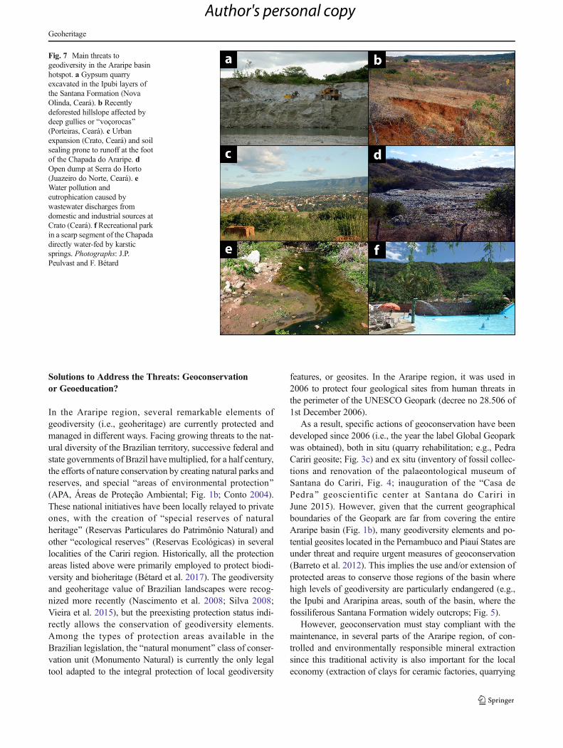
Another damaging activity of major importance in thelocal context is mineral extraction, with the Rio daBatateiras and Santana formations industrially exploited forclay (ceramic factories), gypsum (Ipubi Member; Fig. 7a),and laminated limestone (ornament rocks, pavement, cementmaking; Crato Member). Besides the removal of geologicalspecimens and fossils (Vilas-Boas et al. 2012), quarrying ormining also results in partial or total degradation of land-forms, with some visual impacts and geomorphic changeson the landscapes. In post-mining sites, infilling of excava-tion pits or technical reclamation, consisting of coveringsites by topsoil or overburden, may also cause significantnegative impacts, such as a loss of geological exposuresand/or palaeoenvironmental information (Gray 2013). Thatis the case of many clay pits or gypsum quarries locally usedfor storage of inert waste after exploitation. However, incases of restoration with the aim to conserve quarrying land-forms and geological exposures, the quarry may be viewedas a factor of increasing geodiversity because of the new
landforms and the geological window created by quarrying(Dávid 2008; Prikryl 2009; Bétard 2013). In the AraripeGeopark, for instance, the site locally known as BMinaTriunfo^ is a former quarry of fossiliferous laminated lime-stone (Crato Member of the Santana Formation) which wassuitably restored and now belongs to the network ofgeotouristic sites of the UNESCO Geopark (Pedra doCariri geosite; Fig. 3c).
The threats to pedodiversity are of major concern aswell. Several human activities (e.g., deforestation, intensiveagriculture) are responsible for the degradation of soil pro-files and structure, including compaction and loss of organ-ic matter, and may result in soil acidification and acceler-ated erosion processes (see, for instance, the rapid forma-tion of deep Bvoçorocas^ in recently deforested hillslopesof the Chapada; Fig. 7b). More substantial threats are prob-ably posed by the accelerated urban development of theCRAJUBAR (Crato–Juazeiro do Norte–Barbalha) conurba-tion in the Ceará part of the basin (Fig. 7c). With this fast-growing urban area of >450,000 inhabitants, deforestationand soil sealing are rapidly increasing in all geomorpholog-ical units, including the lower slopes of the escarpmenthighly prone to surface runoff, with the effect of accentu-ating hazards such as flash floods at the origin of more andmore damages in the cities of Crato and Barbalha(Magalhães and Peulvast 2013). While rapid urbanizationis taking place toward the Chapada around Crato,geodiversity features are progressively destroyed due tothe absence of urban or environmental planning taking intoaccount the values of geodiversity elements. These factspoint out a certain inadequate legislation in terms of inte-grating geodiversity into protected area management.
In the study area, pollution remains one of the majorproblems with dramatic consequences on soil and waterresources. Open refuse dumps are still frequent in theCariri region—in spite of recent projects of confined,engineered landfill sites at a metropolitan scale—and of-ten cause significant contamination of soil, surface water,and groundwater through leaching and percolation ofwaste pollutants at depth (Fig. 7d). Contamination ofwater bodies and rivers by domestic and industrial sew-age is a general phenomenon in the absence of an effi-cient system of wastewater collection and treatment bythe municipalities (Fig. 7e). Private appropriation of sitesand water resources (illegal pumping and directconnection to springs; Fig. 7f) finally reveals a relativeinefficiency of local authorities to enforce environmentalregulation and to protect hydrodiversity. In this last case,the result is that originally semi-permanent creeks andrivers, including the Salgado river which collects all thewater of the Cariri depression, are now completely dryduring the major part of the year or replaced by smallstreams of polluted and stinking water.
Geoheritage
Author's personal copy
Solutions to Address the Threats: Geoconservationor Geoeducation?
In the Araripe region, several remarkable elements ofgeodiversity (i.e., geoheritage) are currently protected andmanaged in different ways. Facing growing threats to the nat-ural diversity of the Brazilian territory, successive federal andstate governments of Brazil havemultiplied, for a half century,the efforts of nature conservation by creating natural parks andreserves, and special Bareas of environmental protection^(APA, Áreas de Proteção Ambiental; Fig. 1b; Conto 2004).These national initiatives have been locally relayed to privateones, with the creation of Bspecial reserves of naturalheritage^ (Reservas Particulares do Patrimônio Natural) andother Becological reserves^ (Reservas Ecológicas) in severallocalities of the Cariri region. Historically, all the protectionareas listed above were primarily employed to protect biodi-versity and bioheritage (Bétard et al. 2017). The geodiversityand geoheritage value of Brazilian landscapes were recog-nized more recently (Nascimento et al. 2008; Silva 2008;Vieira et al. 2015), but the preexisting protection status indi-rectly allows the conservation of geodiversity elements.Among the types of protection areas available in theBrazilian legislation, the Bnatural monument^ class of conser-vation unit (Monumento Natural) is currently the only legaltool adapted to the integral protection of local geodiversity
features, or geosites. In the Araripe region, it was used in2006 to protect four geological sites from human threats inthe perimeter of the UNESCO Geopark (decree no 28.506 of1st December 2006).
As a result, specific actions of geoconservation have beendeveloped since 2006 (i.e., the year the label Global Geoparkwas obtained), both in situ (quarry rehabilitation; e.g., PedraCariri geosite; Fig. 3c) and ex situ (inventory of fossil collec-tions and renovation of the palaeontological museum ofSantana do Cariri, Fig. 4; inauguration of the BCasa dePedra^ geoscientific center at Santana do Cariri inJune 2015). However, given that the current geographicalboundaries of the Geopark are far from covering the entireAraripe basin (Fig. 1b), many geodiversity elements and po-tential geosites located in the Pernambuco and Piauí States areunder threat and require urgent measures of geoconservation(Barreto et al. 2012). This implies the use and/or extension ofprotected areas to conserve those regions of the basin wherehigh levels of geodiversity are particularly endangered (e.g.,the Ipubi and Araripina areas, south of the basin, where thefossiliferous Santana Formation widely outcrops; Fig. 5).
However, geoconservation must stay compliant with themaintenance, in several parts of the Araripe region, of con-trolled and environmentally responsible mineral extractionsince this traditional activity is also important for the localeconomy (extraction of clays for ceramic factories, quarrying
Fig. 7 Main threats togeodiversity in the Araripe basinhotspot. a Gypsum quarryexcavated in the Ipubi layers ofthe Santana Formation (NovaOlinda, Ceará). b Recentlydeforested hillslope affected bydeep gullies or Bvoçorocas^(Porteiras, Ceará). c Urbanexpansion (Crato, Ceará) and soilsealing prone to runoff at the footof the Chapada do Araripe. dOpen dump at Serra do Horto(Juazeiro do Norte, Ceará). eWater pollution andeutrophication caused bywastewater discharges fromdomestic and industrial sources atCrato (Ceará). f Recreational parkin a scarp segment of the Chapadadirectly water-fed by karsticsprings. Photographs: J.P.Peulvast and F. Bétard
Geoheritage
Author's personal copy
of laminated limestone and gypsum for construction geoma-terials). As a compromise between in situ conservation andsocio-economic development, two strategies might beadopted according to the geographical scale of political inter-vention: (1) at the regional scale, we may recommend extend-ing the perimeter of the APA Chapada do Araripe—aprotected area based on sustainable use of natural resources(Conto 2004)—because its present borders are defined byelevation-based contour lines (>500 m a.s.l. in the Ceará,>640 m a.s.l. in the Pernambuco, >480 m a.s.l. in the Piauí)whereas a major part of threatened geodiversity is locatedbelow these altitudes (Fig. 1b); inside this perimeter, quarry-ing or mining would be tolerated and legally controlled; (2) atthe local scale, another recommendation would be to createstrictly protected areas (e.g., natural monuments and reserves)on the most sensible and threatened geosites located outsidethe Araripe Geopark; in this type of integral protection,quarrying or mining would be prohibited as would anyhuman activity having impacts on local geodiversity. As acomplementary method to in situ conservation, anotherstrategy to preserve fossils from illegal collecting is the exsitu creation of palaeontological museums, as proposed byBarreto et al. (2016) in some of the Araripe municipalitieswithin the Pernambuco state. Beyond their efficiency asgeoconservation tools, these museums might also support sus-tainable local development through geotourism (Farsani et al.2011) in a rural area with persistent socio-economicdifficulties.
In such a context, the power of geoeducation for publicawareness on the values of geodiversity appears as an alterna-tive, promising way in this developing region. Becausegeoeducation is one of the objectives of UNESCO’sGeopark strategies, many geoeducational activities are alreadyorganized in the Araripe Geopark for scholars and also for thegeneral public (seminars, school class excursions, educationalworkshops…), mainly to raise local community awareness onthe importance of protecting the environment and thepalaeontological heritage (e.g., actions to prevent illegalcollecting of fossils). Interpretative centers of the Crato office,the PMSC and the BCasa de Pedra^ at Santana do Cariri pro-vide logistic support to communicate geoscientific knowledgeto the public. Given their potential for public awareness on theimportance to preserve geodiversity, geoeducational purposesshould be improved in the Geopark itself (for example on theHorto Geosite, where mainly cultural and religious informa-tion is given, whereas the geological and geomorphologicalexplanations remain hardly evoked) and extended to areasoutside the Geopark (e.g., south of the basin) and to otherenvironmental problems that affect geodiversity as the pollu-tion of soils and waters.
A major challenge in geoeducation in the Araripe regionconcerns the prevention of natural hazards and risks (e.g.,floods, landslides). This new challenge is meaningful since
the Shimabara Declaration (approved during the 5thInternational UNESCO Conference on Geoparks, 2012,Japan) has alerted Geoparks on the need to address these is-sues, particularly in high vulnerable and geohazard-proneareas. In the Cariri region, the notion of natural risk remainspoorly pregnant in the mentalities and behaviors of the inhab-itants as well as the local actors, and it does not feature inmanagement and urban planning, except in the form of moreor less isolated technical measures responding to successivecrises (Magalhães et al. 2010; Magalhães and Peulvast 2013).Inside the Araripe Geopark, the catastrophic floods of theGrangeiro River, which regularly damaged the city of Crato,are a good example of the sudden events which threaten prop-erties, infrastructures, and lives in the region. Being morefrequent than the large-scale mass movements recently dis-covered in the rim of the Chapada do Araripe (Peulvast et al.2011), the floods, particularly flash floods, remain poorlystudied and treated, in spite of the numerous political an-nouncements repeated after each flood. Because landslidesand floods are natural hazards related to geomorphologicaland hydrological processes, a new mission of the AraripeGeopark should be to develop educational actions on georisksthat directly threaten the local population. In our opinion, thisis a powerful way of improving communications ongeosciences and on the importance of taking into accountgeodiversity in land-use planning.
Conclusion
By focusing on the Araripe basin and immediate surround-ings, this study refers to one of the most significant and mostthreatened reservoirs of geodiversity in Brazil. According toits varied geodiversity attributes and to the numerous threatswe identified both inside and outside the UNESCO Geopark,the Araripe basin undoubtedly belongs to the category ofBglobal geodiversity hotspots^ (Bétard 2016), notably be-cause of its high extrinsic geodiversity (e.g., fossil endemism)which, in particular, is threatened. Of particular relevance tothe aim of this study, we have demonstrated that the regionalgeodiversity is far from being limited to its palaeontologicalcomponent which gives a worldwide recognition and includeshigh levels of geomorphodiversity, pedodiversity, andhydrodiversity, which have been inventoried and identifiedboth in intrinsic and extrinsic ways. By assessing all the com-ponents of geodiversity, this study provides qualitative sup-port for the establishment of geoconservation strategies at thescale of the whole Araripe basin, going beyond administrativeboundaries such as state borders or Geopark boundaries.Further works should apply complementary, numericalmethods in order to quantify geodiversity and its loss in theAraripe region and, thus, guide novel geoconservation strate-gies with respect to the legal framework and local contexts.
Geoheritage
Author's personal copy
This study has already highlighted that geoeducation effortsare still needed both inside and outside the Araripe Geopark,in the field of geodiversity and geoheritage awareness as wellas on the prevention of geohazards which directly threaten thevulnerable population of this interior area of northeasternBrazil.
References
Assine ML (1994) Paleocorrentes e paleogeografia na Bacia do Araripe,Nordeste do Brasil. Revista Brasileira de Geociências 24:223–232
Assine ML (2007) Bacia do Araripe. Boletim de Geociências daPetrobrás 15(2):371–389
Assine ML (2014) Sequências deposicionais do Andar Alagoas da Baciado Araripe. Nordeste do Brasil B Geoci Petrobras 22(1):3–28
Barreto AMF, Brilha JB, Cavalcanti RR, Carvalho RA, Ghilardi AMA(2016) Criação de Museus como Estratégia para Preservação doPatrimônio Fossilífero da Bacia Sedimentar do Araripe emPernambuco, NE do Brasil. Anuario do Instituto de Geociencias—UFRJ 39(2):36–42
Barreto AMF, Brilha JB, Sales AMF, Almeida JAC (2012) Patrimôniopaleontológico e geoconservação da Formação Santana (CretáceoInferior da Bacia do Araripe, Pernambuco e Piauí : Nordeste doBrasil). In I Congresso Internacional Geociências na CPLP: 240anos de Geociências na CPLP. Centro de Geociências e Centro deGeofísica da Universidade de Coimbra, 311–320
Baudin F, Berthou PY (1996) Environnement de dépôt de la matièreorganique des sédiments aptiens-albiens du bassin d'Araripe (NEdu Brésil). Bull Centres Rech Explor Prod Elf-Aquitaine 20:213–227
Bétard F (2007) Montagnes humides au cœur du Nordestebrésilien semi-aride : le cas du massif de Baturité (Ceará).Apports d’une approche morphopédologique pour laconnaissance et la gestion des milieux. PhD thesis (unpub-lished), Univ Paris-Sorbonne
Bétard F (2012) Spatial variations of soil weathering processes in a trop-ical mountain environment: the Baturité massif and its piedmont(Ceará, NE Brazil). Catena 93:18–28
Bétard F (2013) Patch-scale relationships between geodiversity and bio-diversity in hard rock quarries: case study from a disused quartzitequarry in NW France. Geoheritage 5:59–71
Bétard F (2016) Geodiversity hotspots: a proposed conceptual and meth-odological framework for defining geoconservation priorities.European Geoscience Union General Assembly, GeophysicalResearch Abstracts 18:1825
Bétard F, Peulvast JP, Claudino Sales V (2005) Laterite preservation andsoil distribution in the Araripe-Campos Sales area: consequences ofuplift, erosion and climatic change. 6th International Conference onGeomorphology, Zaragoza, Abstracts Volume, 69
Bétard F, Peulvast JP, Magalhães AO, Freitas FI (2017) Géopatrimoine etbiopatrimoine, à la croisée entre conservation et développement.Une approche des trajectoires patrimoniales dans le Cariri duCeará (Nordeste brésilien). Annales de Géographie, in press
Carvalho IDS, Novas FE, Agnolín FL, Isasi MP, Freitas FI, Andrade JA(2015) A new genus and species of enantiornithine bird from theearly Cretaceous of Brazil. Brazilian Journal of Geology 45(2):161–171
Cavalcante A (2005) Jardins suspensos no Sertão. Scientific AmericanBrasil 32:69–73
Conto RG (2004) Atlas de conservação da natureza brasileira. Unidadesfederais, Metalivros, São Paulo
Corsini M, Vauchez A, Archanjo CJ, Jardim de Sá EF (1991) Straintransfer at continental scale from a transcurrent shear zone to atranspressional fold belt: the Patos–Seridó system, northeasternBrazil. Geology 19:586–589
Costa VD (1999) Recursos hídricos. In: Gervaiseau P (Ed.) ProjetoAraripe, vol. 5. MMA, FUNDETEC, URCA, Crato, pp 622–713
CPRM-Serviço Geológico do Brasil (2001) Geologia, tectônica erecursos minerais do Brasil . Sistema de InformaçõesGeográficas—SIG e mapas na escala 1:2,500,000. ServiçoGeológico do Brasil, 4 CD Rom
CPRM-Serviço Geológico do Brasil (2003) Atlas digital de geologia erecursos minerais do Ceará. Mapas na escala 1:500,000. ServiçoGeológico do Brasil, CD Rom
Cruz R, Goy JL, Zazo C (2014) Hydrological patrimony in the moun-tainous areas of Spain: geodiversity inventory and cataloguing of thesierras de Béjar and del Barco (in the sierra de Gredos of the centralsystem). Environ Earth Sci 71(1):85–97
Dávid L (2008) Quarrying: an anthropogenic geomorphological ap-proach. Acta Montan Slov 13:66–74
Da Rosa AAS, Garcia AJV (2000) Palaeobiogeographic aspects of north-east Brazilian basins during the Berriasian before the break up ofGondwana. Cretac Res 21:221–239
Farsani NB, Coelho C, Costa C (2011) Geotourism and geoparks as novelstrategies for socio-economic development in rural areas. Int J TourRes 13:8–81. doi:10.1002/jtr.800
Ferreira VP, Sial AN, Jardim de Sa EF (1998) Geochemical and isotopicsignatures of Proterozoic granitoids in terranes of the Borboremastructural province, northeastern Brazil. J S Am Earth Sci 11(5):439–455
Guichard E (1970) Les sols du Bassin du Rio Jaguaribe. MémoireORSTOM 40, Paris
Gray M (2013) Geodiversity: valuing and conserving abiotic nature, 2ndedition. Wiley-Blackwell
Herzog H, Sales A, Hillmer G (2008) The UNESCO Araripe Geopark: ashort story of the evolution of life, rocks and continents. ExpressãoGráfica e Editora, Fortaleza
Ibáñez JJ, Krasilnikov PV, Saldaña A (2012) Archive and refugia of soilorganisms: applying a pedodiversity framework for the conservationof biological and non-biological heritages. J Appl Ecol 49(6):1267–1277
IPECE (2007) Classes de Solos. Ceará em Mapas, IPECE—Instituto dePesquisa e Estratégia Econômica do Ceará
IUSS Working Group WRB (2015) World Reference Base for SoilResources 2014, update 2015. International soil classification sys-tem for naming soils and creating legends for soil maps. World SoilResources Reports No. 106. FAO, Rome
Lazzerini FT (2015) Hydrodiversity: concept and contract propose.Congreso Internacional del Agua—Termalismo y Calidad de Vida.Campus da Auga, Ourense, 1p
Magalhães AO, Peulvast JP (2013) Aléas et risques naturels dansl’intérieur semi-aride du Nordeste brésilien : la crue-éclair du RioGrangeiro (Crato, Ceará) du 28 janvier 2011. EchoGéo 26: http://echogeo.revues.org/13596
Magalhães AO, Peulvast JP, Bétard F (2010) Geodinâmica, perigos eriscos ambientais nas margens úmidas de planaltos tropicais:levantamento preliminar na região do Cariri oriental (Ceará,Brasil). Anais do IV Seminario Latino-Americano de GeografiaFisica, Coimbra, pp 1–12
Martill DM (1993) Fossils of the Santana and Crato Formations, Brazil.In: Jarzembowski EA (Ed.) Palaeontol. Ass. Field Guides to fossils5, pp 9–50
Martill DM (2007) The age of the Cretaceous Santana formation fossilKonservat Lagerstätte of north-east Brazil: a historical review and anappraisal of the biochronostratigraphic utility of its palaeobiota.Cretac Res 28(6):895–920
Geoheritage
Author's personal copy
Martill DM, Bechly G, Loveridge RF (2007) The Crato fossil beds ofBrazil: window into an ancient world. Cambridge University Press,Cambridge
Matos RMD (1992) The northeast Brazilian rift system. Tectonics 11:766–791
Matos RMD (2000) Tectonic evolution of the Equatorial South Atlantic.In: Mohriak W, Taiwani M (eds) Atlantic rifts and continental mar-gins. Geophys Monograph 115, Am Geophys Union, pp 331–354
Mochiutti NF, Guimarães GB, Moreira JC, Lima FF, Freitas FI (2012) OsValores da Geodiversidade: Geossítios do Geopark Araripe/CE.Anuário do Instituto de Geociências – UFRJ 35(1):173–189
Myers N, Mittermeier RA, Mittermeier CG, da Fonseca GAB, Kent J(2000) Biodiversity hotspots for conservation priorities. Nature403:853–858
Nascimento MAL, Ruchkys UA, Mantesso-Neto V (2008)Geodiversidade, geoconservação e geoturismo. Trinômiaimportante para a proteção do patrimônio geológico. Soc BrasGeol, São Paulo
Nemčok M (2016) Rifts and passive margins: structural architecture, ther-mal regimes, and petroleum systems. Cambridge University Press.
Neves SP (2015) Constraints from zircon geochronology on the tectonicevolution of the Borborema Province (NE Brazil): widespreadintracontinental Neoproterozoic reworking of a Paleoproterozoic ac-cretionary orogen. J S Am Earth Sci 58:150–164
Panizza M (2009) The geomorphodiversity of the dolomites (Italy): a keyof geoheritage assessment. Geoheritage 1(1):33–42
Pereira P, Pereira D, Santos L, Silva J (2015) Quantification of a newwater diversity index for large areas using GIS. Examples in ParanáState, Xingu river basin (Brazil) and Portugal. XIV ReuniónNacional de Cuaternario, Granada, 4 p
Pereira DI, Santos L, Silva J, Pereira P, Brilha JB, Silva J, Rodrigues C(2012) Mapping regional geodiversity in Brazil and Portugal.Geologia dell’Ambiente, Suppl 3:107–108
Peulvast JP, Bétard F (2015a) A history of basin inversion, scarp retreatand shallow denudation: the Araripe Basin as a keystone for under-standing long-term landscape evolution in NE Brazil.Geomorphology 233:20–40. doi:10.1016/j.geomorph.2014.10.009
Peulvast JP, Bétard F (2015b) Landforms and landscape evolution of theEquatorial margin of Northeast Brazil. An overview, Springer, EarthSystem Sciences Series
Peulvast JP, Bétard F, Magalhães AO (2011) Scarp morphology and iden-tification of large-scale mass movements in tropical tablelands: the
eastern Araripe basin (Ceará, Brazil). Géomorphologie : relief,processus, environnement 1:33–52
Peulvast JP, Claudino Sales V, Bétard F, Gunnell Y (2008) Low post-Cenomanian denudation depths across the Brazilian northeast: im-plications for long-term landscape evolution at a transform continen-tal margin. Glob Planet Chang 62:39–60
Ponte FC, Ponte-Filho FC (1996) Estrutura geológica e evoluçãotectônica da Bacia do Araripe. MME/DNPM, Recife
Prikryl R (2009) Geomorphosites and quarries. In: Reynard E, Coratza P,Regolini-Bissig G (eds) Geomorphosites. Verlag Dr. Friedrich Pfeil,München, pp 225–233
RadamBrasil P (1981) Levantamento integrado dos recursos naturais doBrasil. Folha Jaguaribe-Natal. Ministério das Minas e Energia-MME, Brasilia
Simić S (2011) Hydrological heritage within protection of geodiversity inSerbia—legislation history. Journal of the Geographical InstituteJovan Cvicić 61(3):17–32
Santos TJS, Fetter AH, Hackspacher PC, Van Schmus WR, Neto JN(2008) Neoproterozoic tectonic and magmatic episodes in the NWsector of Borborema Province, NE Brazil, during assembly of west-ern Gondwana. J S Am Earth Sci 25(3):271–284
Schobbenhaus C, Campos DA, Queiroz ET, Winge M, Berbert-BornMLC (Ed.) (2002) Sítios Geológicos e Paleontológicos do Brasil.Vol. 1. DNPM/CPRM—Comissão Brasileira de Sítios Geológicos ePaleobiológicos (SIGEP), Brasília
Silva CR (2008) Geodiversidade do Brasil: conhecer o passado, paraentender o presente e prever o futuro. CPRM, Serviço Geológicodo Brasil
Tardy Y, Roquin C (1998) Dérive des continents, paléoclimatset altérations tropicales. Ed BRGM, Orléans
Valença LMM, Neumann VH, Mabesoone JM (2003) An overview onCallovian-Cenomanian intracratonic basins of Northeast Brazil: on-shore stratigraphic record of the opening of the southern Atlantic.Geol Acta 1:261–275
Vieira BC, Salgado A, Santos L (Eds) (2015) Landscapes and landformsof Brazil. Springer, World Geomorphological Landscapes Series
Vilas-Boas M, Lima F, Brilha J (2012) Conservation of thepalaeontological heritage of Araripe Geopark (Ceará, Brazil): threatsand possible solutions. Geologia dell’Ambiente, Suppl 3:87–88
Winter T, Harvey J, Franke O, Alley W (1998) Ground water and surfacewater: a single resource. U.S. Geological Survey Circular 1139
Geoheritage
Author's personal copy