Embed Size (px)
Citation preview
Project title: Keswick-Airport Towers 3/2 and 3/3 Access Roads
Requested By: Michael Prowatzke Mail Code : N1420 Phone: 916-353-4081
Date Submitted: 4-1-16 Date Required: 4-4-2016
Description of the Project: Western Area Power Administration (Western), Sierra Nevada Region, is proposing to obtain an easement and construct an access road to serve tower 3/2 on the Keswick-Airport line in Redding, and to install two gates—one on this proposed access road and a second on the existing access road to tower 3/3. The current access to tower 3/2 consists merely of a right-of-way (ROW) footpath from tower 3/3, but this is insufficient for vehicle access, and it crosses an intermittent creek. The proposed access road would improve about 1050’ of a faint two-track route originating at a condominium complex and create about 200’ of new access road across open woodland. The proposed route would completely avoid the creek bed. Light grading and installation of rolling dips to reduce erosion would be employed per Western’s standards. Western would abandon use of the ROW footpath, though it is likely to continue to be used as a hiking trail by local residents. The two gates would be installed where the two access roads leave the public road. No additional improvement to the tower 3/3 access road other than the gate installation is planned. The scheduled work is anticipated to occur in the summer of 2016.
Location of the Project: The Keswick-Airport 230-kV towers 3/2 and 3/3 lie within the city limits of Redding, CA, near the Ridgecrest Condos. Both access roads branch off of Ridgetop Drive and continue into the ROW by the shortest distance.
Attachments: Maps
Note: Map deleted on public version for the protection of archaeological resources.
Work Order Number: 100153025


Western Area Power
Administration Sierra Nevada Region
CATEGORICAL EXCLUSION (CX) DETERMINATION
Project Number: 100153025
Integral Elements
Project Title: Keswick-Airport Towers 3/2 and 3/3 Access Roads
Category of Action: B1.13: Pathways, short access roads, and rail lines
Construction, acquisition, and relocation, consistent with applicable right-of-way conditions and approved land use or transportation improvement plans, of pedestrian walkways and trails, bicycle paths, small outdoor fitness areas, and short access roads and rail lines (such as branch and spur lines).
Regulatory Requirements for a Categorical Exclusion Determination: The Department of Energy (DOE), National Environmental Policy Act (NEPA) Implementing Procedures, 10 CFR 1021.410(b) require the following determinations be made in order for a proposed action to be categorically excluded (see full text in regulation).
1. The proposed action fits within a class of action listed in Appendixes A and B to Subpart
D. For classes of actions listed in Appendix B, the following conditions are integral elements; i.e., to fit within a class, the proposal must not:
a. Threaten a violation of applicable statutory, regulatory, or permit requirements for environment, safety, and
health, including requirements of DOE and/or Executive Orders.
b. Require siting and construction or major expansion of waste storage, disposal, recovery, or treatment facilities, but may include categorically excluded facilities.
c. Disturb hazardous substances, pollutants, contaminants, or CERCLA-excluded petroleum and natural gas
products preexisting in the environment such that there would be uncontrolled or un-permitted releases; or
d. Adversely affect environmentally sensitive resources (including but not limited to those listed in paragraph B (4)).
2. There are no extraordinary circumstances related to the proposal which may affect the
significance of the environmental effects of the proposal;
3. The proposal is not connected to other actions with potentially significant impacts (40 CFR 1508.25(a)(I)), is not related to other actions with cumulatively significant impacts (40 CFR 1508.25(a)(2)), and is not precluded by 40 CFR 1506.1 or 10 CFR 1021.211.
Results of Review: In accordance with DOE environmental regulations (10 CFR 1021), Western has reviewed the proposed action in terms of the level of NEPA review needed. Based on this review, Western has determined the proposal is encompassed within a class of action listed in Appendix B to Subpart D (10 CFR 1021.410) which do not require preparation of either an environmental impact statement or an environmental assessment (EA).
The proposed action meets the above regulatory criteria and there are no significant adverse environmental effects associated with this action.

Western Area Power Administration,
SIERRA NEVADA REGION NEPA Attachment Sheet
Project Number 100153025
PROJECT TITLE: Keswick-Airport Towers 3/2 and 3/3 Access Roads AFFECTED ENVIRONMENT The project area is located in a suburban setting within the City of Redding near Ridgetop Drive.
The area of the REVIEW ACTION Habitat type within the project area was compared to the California Natural Diversity Database
(CNDDB) and U.S. Fish and Wildlife sensitive species lists for species that may occur in the area. Based on habitat type within and around the site, there was limited potential for elderberry shrubs (i.e., habitat for the threatened valley elderberry longhorn beetle) or for trees protected by local ordinances to occur in the project area. Site surveys were conducted on February 22, 2016 by Western’s contracted biologist, and by a contracted archaeologist the week of March 21, 2016.
CULTURAL AND HISTORIC RESULTS A pedestrian survey of the proposed new access road for the Keswick-Airport line was
conducted March 21, 2016. A previously-recorded site near to the proposed access road was found. This is site P-45000893, a scatter of lithic debitage and meta-volcanic cores. See attached kmz file for location of site. The site is approximately 100 feet from the proposed access road at the extreme southern turn. Work crews are not to use the existing turn-around loop adjacent to the proposed access road and the cultural site on the south side of the transmission line. They are fine using the access road, as proposed.
Consultation on this project was completed on: This action is covered by Western's Programmatic Agreement, “Programmatic Agreement
Among the Western Area Power Administration, the Advisory Council on Historic Preservation, and the California State Historic Preservation Officer Concerning Emergency and Routine Maintenance Activities and Other Routine Activities at Western Facilities in California,” revised March, 2010.
Mitigation required: None Include in Western’s annual report
BIOLOGICAL RESULTS No special status species, habitats, or protected trees are located within the project area.
Wetlands and jurisdictional waters are neither located in the area of, nor have potential to be affected by, the project.
Studies conducted, in order to evaluate potential impacts of the proposed project on special status species and/or their habitats, included background research to determine which special-status species and their habitats may occur within the project area and a review of habitat types in the project area. Avoidance measures for migratory birds are detailed below.
Mitigation required (see below)
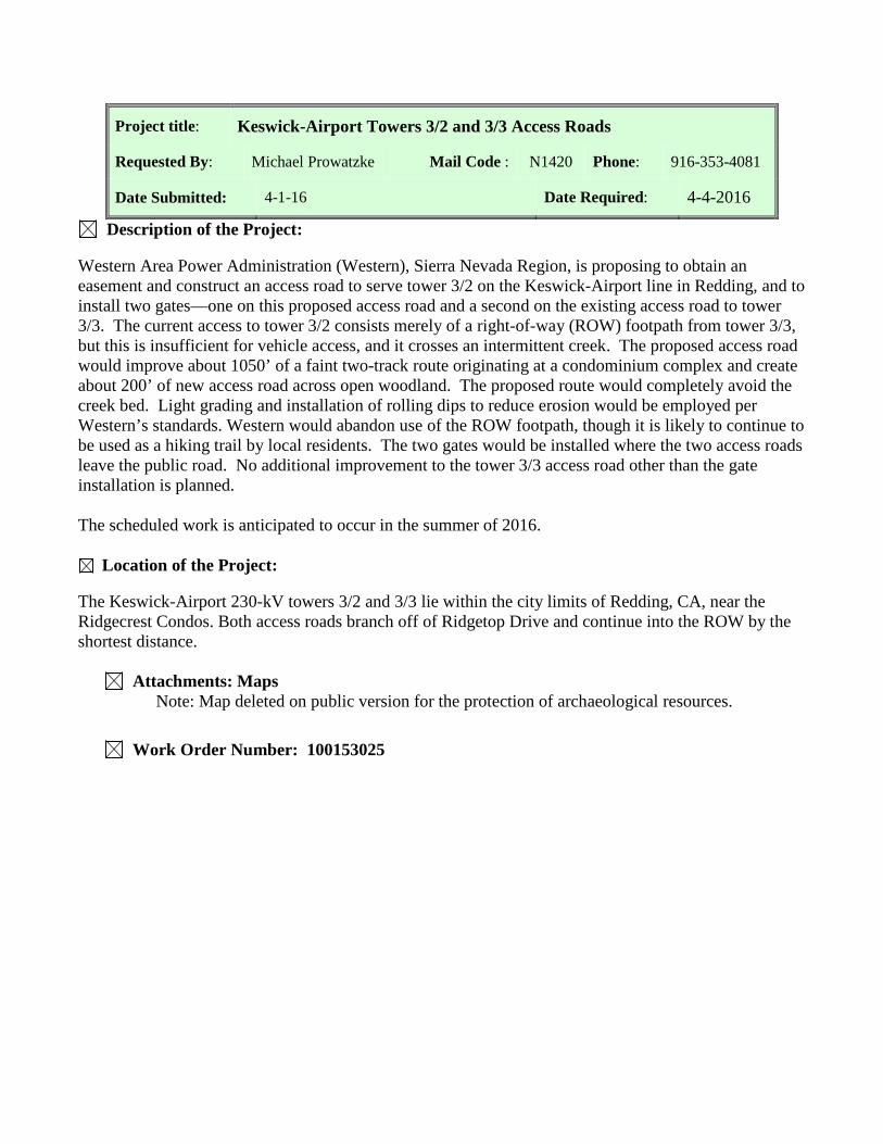
COMPLIANCE RESULTS Recycled Materials Quantities: All materials generated from the project that can be recycled,
shall be recycled. Submit quantities of all recycled material by category to the COR within 30 days of recycling and prior to submittal of final invoice. Record quantities of material by category that is salvaged, recycled, reused, or reprocessed.
Disposal of Waste Material: Dispose or recycle waste material in accordance with applicable Federal, State, and local regulations and ordinances. Coordinate with COR regarding sampling and signatures on manifests for wastes materials if required. Submit quantities of total project waste material disposal as listed below to the COR prior to submittal of final invoice. (1) Unregulated Wastes (i.e., trash): Volume in cubic yards or weight in pounds. (2) Hazardous or Universal Wastes: Weight in pounds. (3) PCB Wastes (If applicable): Weight in pounds. (4) Other regulated wastes (e.g., lead-based paint or asbestos): Weight in pounds (specify type of waste in report).
Pollutant Spill Prevention, Notification, and Cleanup: The Spill Prevention, Notification, and Cleanup Plan is expected to be a brief description of the measures taken by the contractor to prevent spills, to notify in the event of a spill, to train personnel, and to describe the company’s commitment of manpower, equipment, and material which would be mobilized in the event of a spill. The plan should describe those elements in proportion to the risks posed by the project. This not intended to be the Spill Prevention, Control and Countermeasures Plan, as specified in 40 CFR 112. Those plans are required by law for facilities with ≥1320 gallons of oil storage.
Prevention of Air Pollution: Federal law requires the protection of air quality under the Clean Air Act. All activities on this project shall be compliant with Federal, State, and local regulations. In particular, California Air Resources Board regulations apply to diesel equipment and trucks as well as fleets of large spark ignition equipment.
Prevention of Greenhouse Gas Emissions: Federal law requires the reporting of emissions under the Greenhouse Gas Regulation 40CFR98. All emissions of sulfur hexafluoride on this project shall be reported to Natural Resources. Installation and maintenance of equipment containing sulfur hexafluoride or any other greenhouse gas shall be in accordance with management practices designed to eliminate emissions.
Prevention of Water Pollution: Federal law requires the protection of water quality under the Clean Water Act. The project is exempt from the General Permit for Stormwater Discharges Associated with Construction and Land Disturbance Activities issued by the California State Water Board because it consists of routine maintenance activities in an existing right of way, and because the proposed disturbance areas occurring outside that existing right of way measure collectively less than one acre. Construction activities must therefore remain strictly within the boundaries specified in the plans in order to qualify for this exemption. Any increases in ground disturbance outside of the right of way would require an additional permit applicability determination. Best management practices will be used to control runoff from the project areas.
MITIGATION Other Mitigation: Not Required
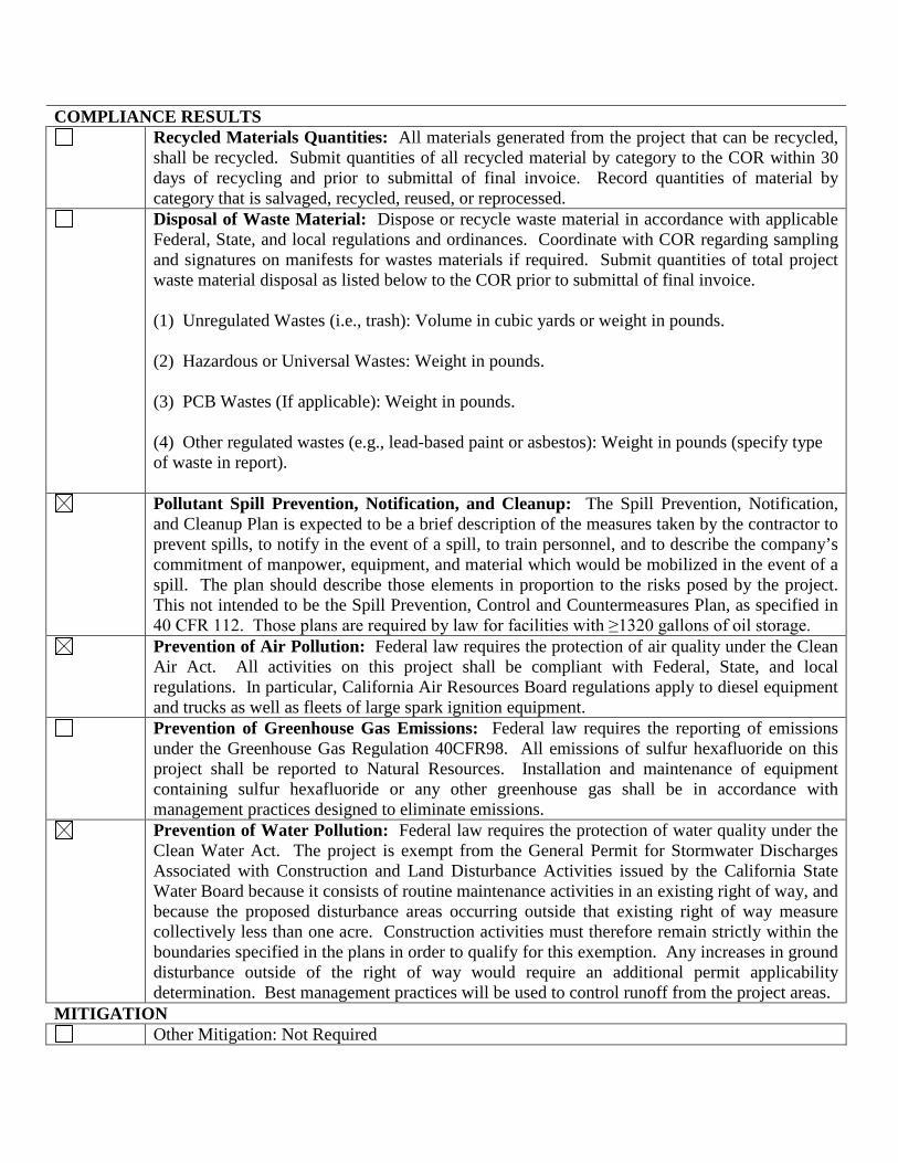
Western Area Power Administration Sierra Nevada Region
Environmental Requirements for the Keswick-Airport Towers 3/2 and 3/3 Access Roads
Project Number 100153025
ITEMS CHECKED ARE APPLICABLE TO THIS PROJECT.
General Under the Migratory Bird Treaty Act of 1918, migratory bird species and their nests and eggs are
protected from injury or death. Impacts to migratory bird nests shall be avoided during the nesting season (January 1 to September 15). If tree/shrub trimming/removal will occur during the nesting season, Western will survey the project area for migratory bird nests prior to project activities and establish appropriate buffers around any active nests that may potentially be disturbed. If work must be conducted within these buffers, a Western supplied biological monitor will be on site for project activities within the buffers. If the biological monitor determines that activities are likely to cause nest impacts or nest abandonment, then project activities in the area shall be postponed or adjusted until nestlings have fledged, the nest is no longer active, or the activities are not likely to cause nest impacts or nest abandonment.
Routine maintenance activities will be avoided from mid-March through mid-June in the vicinity of structures.
Road maintenance operations will be conducted to minimize soil erosion. The United States Forest Service’s Best Management Practices, Forest Practices, and Forest Practices Rules of the California Department of Forestry will be implemented where practical.
Culverts will be sized to match storms that may occur during the life of the road to minimize the potential for access road washouts under high intensity storms.
Excavated material will not be stock piled or deposited on or near stream banks, lake shorelines, or other water course perimeters where they could be washed away by high water or storm run-off or could significantly impact the water course.
Vegetative management plans will be followed as appropriate. In areas where excavation is not required, vegetation will be left in place whenever possible and
original contours maintained in an undisturbed condition. Habitat diversity will be maintained to the greatest extent feasible. Brush blades will be used on bulldozers in clearing operations where such use will help preserve the
cover crop of grass, low-growing brush, etc. Dispose of all cleared vegetation in an appropriate manner. The biologist will determine whether a sensitive habitat is present at the maintenance site. If special
status species are identified in the area, maintenance will receive approval from Natural Resources prior to initiating any maintenance.
Natural Resources will be contacted immediately: a. If there is a "take" of a special status species or action affecting their critical habitat, and/or b. If archeological, paleontological, or historic evidence is found.
No paint or permanent discoloring agents will be applied to rocks or vegetation. If used, survey stakes will be removed as a part of the final clean up. All work on access and maintenance roads must stay within the existing prism of the roads.

Threatened and Endangered Species
Federal law prohibits the taking of endangered, threatened, proposed or candidate wildlife and plants, and destruction or adverse modification of designated Critical Habitat. Federal law also prohibits the taking of birds protected by the Migratory Bird Treaty Act, and the Bald and Golden Eagle Protection Act. “Take” means to pursue, hunt, shoot, wound, kill, trap, capture or collect a protected animal or any part thereof, or attempt to do any of those things.
Known Occurrence of Protected Species or Habitat: Following issuance of the notice to proceed, and prior to the start of construction, Western will provide training to all contractor and subcontractor personnel involved in the construction activity. Untrained personnel shall not be allowed in the construction area. Western will provide two sets of drawings showing known sensitive areas located on or immediately adjacent to the transmission line right-of-way and/or facility. These areas shall be considered avoidance areas. Prior to any construction activity, the avoidance areas shall be marked on the ground in a manner approved by the COR. If access is absolutely necessary, the contractor shall first obtain permission from the COR, noting that a Western and/or other government or tribal agency biologist may be required to accompany personnel and equipment. Ground markings shall be maintained through the duration of the contract. Western will remove the markings during or following final inspection of the project.
Unknown Occurrence of Protected Species or Habitat: If evidence of a protected species is found in the project area, the contractor shall immediately notify the COR and provide the location and nature of the findings. The contractor shall stop all activity in the vicinity of the protected species or habitat and not proceed until directed to do so by the COR.
Prior to the start of project activities, all personnel will participate in environmental awareness training which will inform them of the sensitive habitats within the project area, the species that have the potential to occur in the project area, and the avoidance and minimization measures that are to be adhered to during project activities. Any new crew members that start after project activities have started will be given the environmental awareness training prior to starting work on site.
General Mitigation/Avoidance Measures: The Contractor shall follow all species specific conservation measures listed below as applicable to each site, in coordination with Western’s Natural Resources Point of Contact (POC) and the COR.
Perennial Streams and Rivers
The following activities will be prohibited at all times within 100 feet of a seep, spring, pond, lake, river, stream, or marsh, and their associated habitats:
• Vehicle access, except on existing access and maintenance roads, unless approved by Natural Resources
• Dumping, stockpiling, or burying of any material, except as required for specific O&M activities (e.g., rip-rap)
• Mixing of pesticides, herbicides, or other potentially toxic chemicals • Open petroleum products
Equipment will be stored, fueled, and maintained in a vehicle staging area 300 feet or the maximum distance possible from any seep, spring, pond, lake, river, stream, marsh, or their associated habitats. Vehicles will be inspected daily for fluid leaks before leaving the staging area.
All spills of fuel or hydraulic fluid would be immediately cleaned up according to Western's guidelines for hazardous material handling.
Compliance Regulatory Requirements
No violations of applicable statutory, regulatory, or permit requirements for environment, safety, and health, including requirements of DOE and/or Executive Orders will be permitted.
There will be no uncontrolled or un-permitted releases of hazardous substances, pollutants, contaminants, or petroleum and natural gas products to avoid adversely affecting environmentally sensitive resources.
In the event of a Hazardous Material/Waste spill Environmental staff and the COR will be contacted, Western Dispatch notified, and the appropriate Federal, State, and local regulating authority notified depending on the type and size of the spill (For further guidance, please contact Environment).
Hazardous Materials/Waste on-site to consider: Fueling of equipment; In the right of way, place spill drip pans (or similar) below fueling areas, spill kit and tools available nearby to stop the flow of fuel spills, and employees trained in spill response.
Hazardous Materials/Waste need to be removed off site for disposal/recycling. Piping and oil sampling required Material Analytical Data: See attached results for reference Erosion control measures to be taken Soil Sampling
Map showing location of archaeological site P-45000893. (Map deleted in public version.)