Embed Size (px)
Citation preview

Kevin Behm – Addison County Regional Planning Commission
802-388-3141
Kevin Behm – Addison County Regional Planning Commission
Community
Build-Out
Analysis
August 8, 2006
Kevin Behm – Addison County Regional Planning Commission
Community
Build-Out
Analysis
August 8, 2006

Community Build-Out Analysis
Development started in 1999 as a part of the Community Planning Tools Demonstration Project funded by Sen. Leahy’s Office and administered by the Center for Rural Studies at UVM.
Center for Rural Studies has provided additional funding to improve the program over the past 5 years.
Operates as an extension to the ESRI GIS program ArcView 3.2

What is a Build-Out? A build-out analysis predicts the maximum potential for
development based on town policies and zoning bylaws as well as environmental or geographic constraints to development.
WHY? A planning tool to assess the consequences of existing and proposed planning and zoning practices.
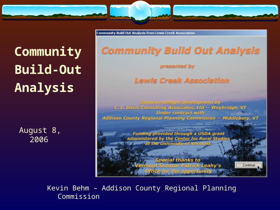
1869 1942

1962 1977

1992 1995
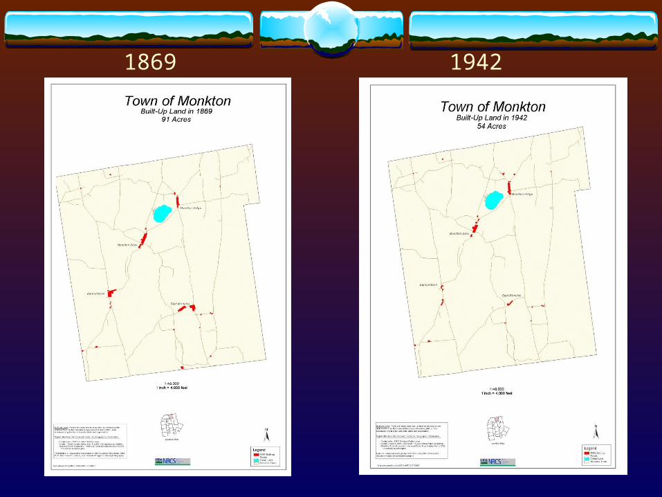
Existing zoning

Build-out under existing zoning
Existing residential – 611 Potential development
with no development in wetlands, floodplain, or forest districts - 3263
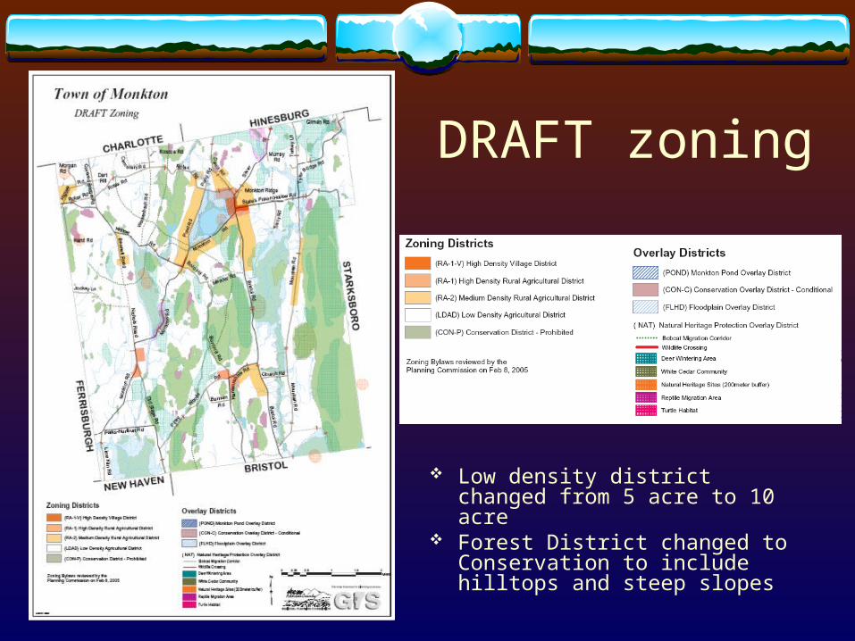
DRAFT zoning
Low density district changed from 5 acre to 10 acre
Forest District changed to Conservation to include hilltops and steep slopes
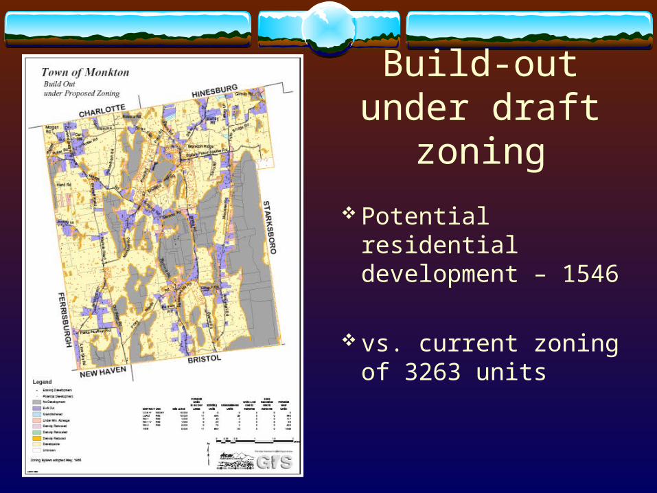
Build-out under draft zoning
Potential residential development – 1546
vs. current zoning of 3263 units

Build-Out Status All parcel/zoning combinations are symbolized with a build-out result
No existing house and under the minimum
lot size ( 1 unit added)
Under the minimum lot size
Density removed using a layer
Density allowed but houses must be relocated off of layer
Density reduced using a layer and fewer houses shown

Compare build-out results - spatial
Development density changes Polygon symbology changes
Existing zoning Draft zoning

Compare build-out results – export to spreadsheet
RA2 (2 ac)571
RA5 (5 ac)2472
RA1 (1 ac)199
WLD (25 ac)0
FOR (25 ac)0
FHA (25 ac)0
Draft zoning
RA-2 (2 ac)404
LDAD (10 ac)
993
RA-1 (1 ac)117
RA-1-V (1 ac)
33
CON-P (10 ac)
0
Existing zoning residential units – 3263
Draft zoning Residential units –1546
Existing zoning

Methodology – Data Needs
Uses existing town GIS data Zoning Tax Parcels E911 Structures or grand
list Natural Resource
Information Data must be current or
updated for accuracy

Methodology – Basic Steps
A. Construct a table of each parcel’s acreage by zoning district
B. Determine existing parcels that are fully developed
C. Calculate potential new development allowed in each zone

Resulting Summary Table by Zone

Methodology – Next Level
Change minimum lot size of ASRR district to 5 acres from 10 acres

Methodology – Compare Tables
Potential units in the ASRR district increase from 181 to 617

Methodology – Com/IndustrialVillage/ Commercial Area
Min Lot Size .33 ac(14,520 sq ft)
Lot Coverage 75%Max Building Hgt 35 ftSq Ft / Parking Sp 200
Existing Development

C/I Summary Table by Zone

Methodology – Location ConstraintsDefine constraint layers
Choose to use or remove the layer area from density calculation
Choose to allow structures in the layer area or restrict placement of potential development
Adjust density of layer areato less than 100%
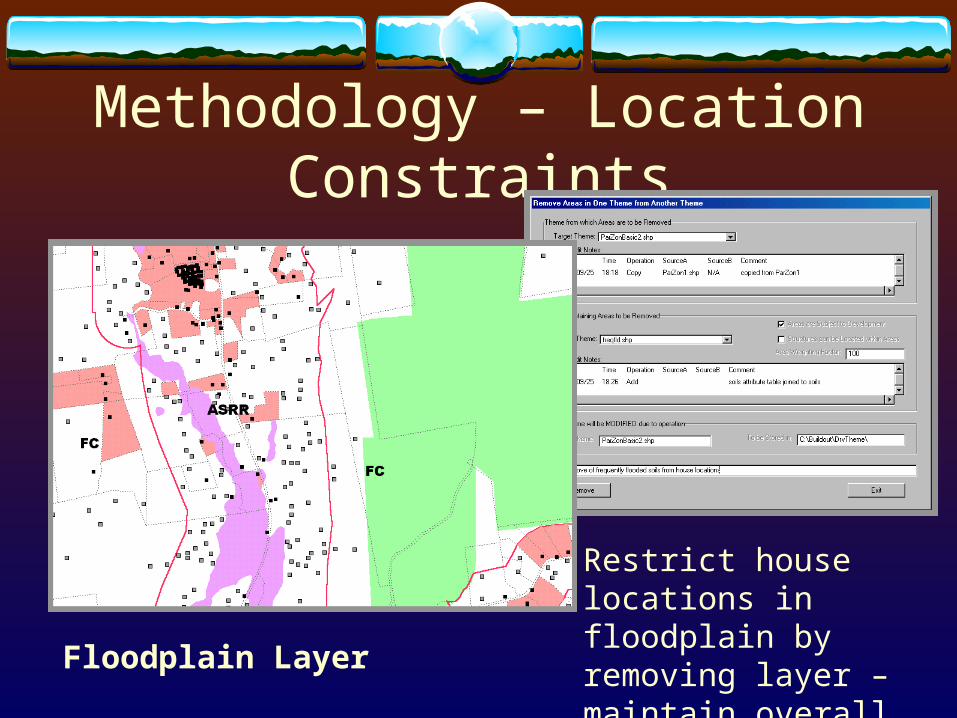
Methodology – Location Constraints
Floodplain Layer
Restrict house locations in floodplain by removing layer – maintain overall density

Next Steps for CBOA1. Continue to use the program with communities.2. Work to improve the currency/accuracy of town data. 3. Improve the program with new ideas from users.
Mixed use districts Time horizon – growth model PUD w/ open space – conservation planning Subdivision lot lines
4. Issues – move to ArcGIS or Web-based5. Funding partners

Acknowledgements
Thanks to the Vermont USDA and Senator Leahy’s staff for originally supporting the Community Planning Tools Demonstration Project and to the Center for Rural Studies at UVM for continuing to provide development support.
In addition, we want to recognize the important land use decisions that are made by the volunteer boards and commissions in each of our communities. We sincerely hope that these tools will be an asset to their efforts.