Embed Size (px)
Citation preview

Groundwater differs from surface water through its physical and chemical environment
Among aquifers there are huge differences with respect to geological environments Resulting in their capacities to store water and
to transmit water flow as well. Hence the availability of groundwater will
depend on hydrogeological setting characterized by hydraulic parameters
Groundwater management requires reliable aquifer characterization.

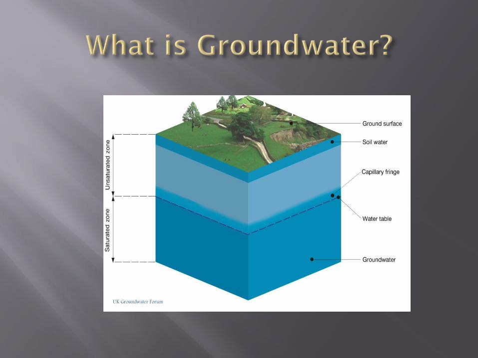
Underlying resource, stored in underground reservoir (rocks) and transmitted through interconnected spaces
Aquifers have huge differences with respect to their hydrogeological setting.
GW management based on a good understanding of aquifer system.

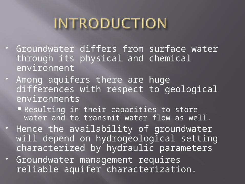
Definition of Groundwater/Hydrogeology
•The rainfall that soaks into the ground and moves downwards into spaces and cracks in the rocks below the ground surface becomes groundwater.
•The study of groundwater is called hydrogeology.

Storage capacity (storage coefficient or specific yield)
Transfer capacity (transmissivity)
Physical and chemical interaction capacity (reservoir-rock vs GW)

UnconsolidatedUnconsolidated rocks: rocks:
• Pore Pore spacesspaces
• Large storageLarge storage
ConsolidatedConsolidated rocks: rocks:
• FracturesFractures
• Small storageSmall storage
ConsolidatedConsolidated rocks: rocks:
• Karsts (Karsts (enlargedenlarged fractures) fractures)
• Large storageLarge storage


Why Groundwater?•A readily available source at point needed•Its relative low costs compared to surface water•Availability in most areas•Potable without treatment•Employs low cost technologies•The frequent drought problems enforce the use of groundwater source as many small intermittent rivers and streams dry out during the dry season

After MacDonald et al, 2005
MinorMinor aquifersaquifers
CriticalCritical issues: issues:
• availabilityavailability
• reliabilityreliability

Groundwater characteristics: Groundwater occurs in most geological
formations because nearly all rocks possess openings (pores or voids, or fractured).
All aquifers have two fundamental characteristics: A capacity for groundwater storage (Porosity )
and; A capacity for groundwater flow (Permeability).
An aquifer is a geological formation capable of yielding useful groundwater supplies to wells and springs.

Aquifer types: unconfined
(free surface), called water-table aquifer or phreatic aquifer;
confined (under pressure) aquifers are bounded by impervious or semipervious layers. (Schmoll, O.,et al. – 2006.)
Hydrogeological environments: The availability of groundwater depends
primarily on the geological environment Aquifer unit storage capacity
(storativity) varies extremely between: Unconsolidated granular sediments, and; Highly-consolidated fractured rocks.
Groundwater flow potential (transmissivity) depends on aquifer saturated thickness and types of aquifer layers (permeability)
Hydrogeological environments: Ancient crystalline and metamorphic:
highly fractured or weathered: permeability is low, the storage capacity as
well. GW potential moderate (0.1 – 1 l/s), since
aquifer is usually of minor extension. Targets: fractures at the base of the deep
weathered zone, and the vertical fracture zones.

Groundwater occurrence in weathered basement rocks (MacDonald et al., 2005)
Hydrogeological environments: Consolidated sedimentary aquifers: large
groundwater storage and major regional extension, → different aquifers types: Sandstones: moderate to high potential (1 – 20 l/s);
Targeting for abstraction: coarse porous or fractured sandstones
Mudstone and shale: fractured or interbedded with sandstone layers; its potential is low (0 – 0.5 l/s) with minor regional flow; Targets: hard fractured mudstone or thin sandstone
layers Limestones: slightly soluble in rainwater →
fractures can be enlarged to form karsts (developed conduits and fracture systems) Its potential is moderate to high (1 – 100 l/s).


Hydrogeological environments: Unconsolidated sedimentary aquifers: loose materials, GW stored and transmitted through pore spaces, not
fractures. Large to very large storage capacity and usually huge
regional extension. Distinguished major hydrogeological units are: Major alluvial and coastal basins: sands, gravels and
clays : High potential (1- 40 l/s), Sands and gravels are targeted
layers. Small riverside deposits: mixed alluvium (cobbles,
gravels, sands, silts clays), and others deposits like coastal dunes (sandy): potential moderate (1 – 20 l/s), sandy/gravel deposits
targeted . Valley deposit in mountain: poorly sorted rock
fragments, sands, gravels, volcanic materials: Moderate to high potential: 1 – 10 l/s, Stables areas of sands
and gravels are interesting targets.
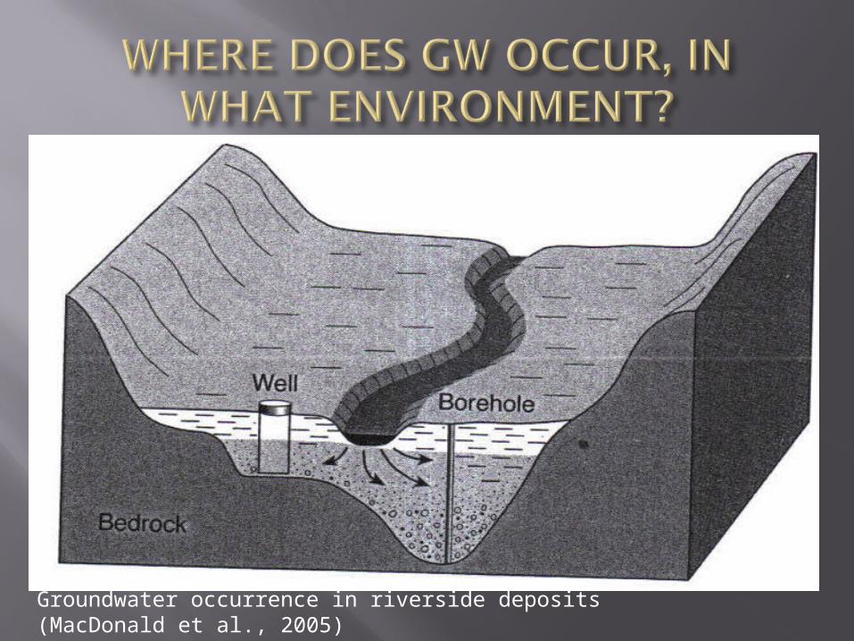
Groundwater occurrence in riverside deposits (MacDonald et al., 2005)
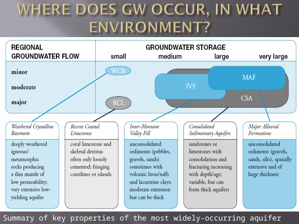
Summary of key properties of the most widely-occurring aquifer types (GW Mate2, 2006)

Groundwater moves slowly through interconnected pore/fracture spaces of aquifers materials.
GW in continuous slow movement from recharge areas (usually upland areas) discharge areas (springs, baseflow, wetlands and coastal zones).
The flow of groundwater through an aquifer is governed by Darcy’s Law.
Aquifer storage transforms highly variable natural recharge regimes into more stable natural discharge regimes.
It also results in groundwater residence times, usually counted in decades, centuries, even millennia: Large volumes of so-called ‘fossil groundwater’ still being
held in storage. Residence time will depend also on aquifer geologic
formations that bear groundwater

Where aquifers dip beneath much less permeable strata, their groundwater becomes confined (to varying degrees) by overlying layers.
This results in a corresponding degree of isolation from the immediately overlying land surface, but not from the groundwater system as a whole.
Drawdown induced by pumping from the confined section of an aquifer is often rapidly propagated to the unconfined section.
In various hydrogeological settings, shallow unconfined and deep confined aquifer layers can be superimposed → leakage downwards and upwards between layers according to local conditions.

Typical groundwater flow regime and residence times of major aquifers under semi-arid climatic regimes (after GW-Mate2, 2006)

GW in continuous slow movement from recharge areas (usually upland areas) discharge areas (springs, baseflow, wetlands and coastal zones)
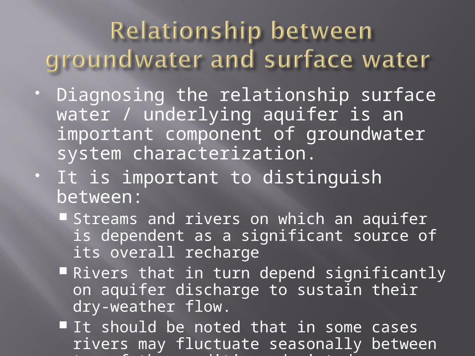
Diagnosing the relationship surface water / underlying aquifer is an important component of groundwater system characterization.
It is important to distinguish between: Streams and rivers on which an aquifer is
dependent as a significant source of its overall recharge
Rivers that in turn depend significantly on aquifer discharge to sustain their dry-weather flow.
It should be noted that in some cases rivers may fluctuate seasonally between two of the conditions depicted.

Spectrum of possible relationships between surface watercourses and underlying groundwater systems (after GW-Mate2, 2006)

Changes to surface water bodies in response to groundwater development can cause significant consequences: Long term reductions in stream flow can affect
vegetation along streams Changes in the flow direction to/from streams may
affect temperature, oxygen levels, and nutrient concentrations in the stream (affect aquatic life)
In gaining and in losing streams, affect hyporheic zones (active sites for aquatic life)

Lowering of lake diminish lakefront aesthetics, and shoreline structures such as docks, may alter the natural fluxes to lakes of key constituents (nutrients and dissolved oxygen)
Amplitude and frequency of water-level fluctuations affect wetland characteristics (type of vegetation, nutrient cycling, type of invertebrates, fish, and bird species)
Lead to reductions in spring flow, changes of springs from perennial to ephemeral, or elimination of springs altogether
Plant and wildlife communities adapted to coastal areas can be affected by changes in the flow and quality of groundwater discharges

Recharge may result from: Precipitation that percolates through unsaturated zone to
water table Losses of surface water bodies (steams, lakes, wetlands)
Contemporary aquifer recharge rates, a fundamental consideration in the sustainability of groundwater resource development.
Understanding aquifer recharge mechanisms and their linkages with land-use is essential for integrated water resources management.
The quantification of natural recharge rates, subject to significant methodological difficulties, data deficiencies and resultant uncertainties because of: Wide spatial and temporal variability of rainfall and runoff
events, and; Widespread lateral variation in soil profiles and
hydrogeological conditions.

Recharge rates vary with: river flow diversion or control, modifications to surface water irrigation, changes in natural vegetation or crop type in
recharge areas, reduction in leakage from urban water-supply
networks and in-situ wastewater percolation, lowering of water-table, etc.
A number of generic observations can be made on aquifer recharge processes: Areas of increasing aridity will have a much
lower rate and frequency of downward flux to the water table,
Indirect recharge from surface runoff and incidental artificial recharge arising from human activity is generally becoming progressively significant than rainfall direct recharge.

To understand groundwater systems and how they respond to external and internal changes, →need to be able to assess groundwater movement: local scale (seepage phenomena, flow near
groundwater wells), regional scale with recharge/discharge of
aquifer systems, interaction of different aquifers, interaction with surface water bodies
Many difficulties encountered in groundwater assessment due to various reasons: groundwater cannot be readily observed, it is
hidden resource usually groundwater occurs in large, and
complex aquifer systems aquifers have high spatial variability of its
characteristics

Safe yield: the attainment and maintenance of a long-term balance between the amount of annual withdrawal and the amount of annual recharge.
This allows water users to abstract groundwater no more than it is replenished naturally.
So-called ‘safe yield’ is clearly bounded by the current long-term average rate of aquifer recharge, although should also consider: value judgements about the importance of
maintaining some of the natural discharges from the aquifer system
consideration of consumptive use and catchment export, as opposed to local non-consumptive uses which result in the local generation of an effluent.

Recharge rate quantification Recharge area vs land-use (GW
protection) Interactions (quantity/ quality) with surface water
bodies Impacts of GW pumping Interbasin/interboundary aquifer

Groundwater cannot be readily observed;
GW may occur in large, and complex aquifer systems;
Aquifers have high spatial variability of its characteristics.

Groundwater
Other stakeholders Policy level
Understanding of GW systemInformation on unit systemKnowledge on aquifer properties, and Technical solutions
Demand side Water provision and management
PoliciesStrategies Regulatory framework
SustainableSustainable developmentdevelopment
GW protectionGW protection

Different ways to assess groundwater: Observation of groundwater levels Pumping tests, to test the response of
groundwater abstraction Hydrogeological investigations to built a
first concept on groundwater resource; Geophysical surveys to find the
groundwater resource, to sit borehole GW budgeting, modelling for better
resource development planning Groundwater Quality need to be
assessed to protect GW resources: Salinity monitoring, Other field measurements
of water quality parameters Analysis of groundwater samples (in field or in
laboratory)

GW location, a big issue in complex hydrogeological setting
Available GWR for current and future use, for different uses…sustainably!
Critical elements: safe yield , overexploitation (negative impacts costs)
Recharge ensures renewability of GW storage, input to the system!
Recharge rate estimate, a critical issue for sustainability of GW development
Recharge area map, for land-use planning and access to

SW and GW (in many cases) hydraulically connected…all too often ignored in water management considerations and policies
Useful management information? maps of high risk areas of extensive GW exploitation
Trend of characteristics as impacted by land-use/change, climate change/variability, water use

Areas and levels (vertical) of naturally-occurring hazards Geological settings potentially bearing affected
groundwater Maps of occurrence of groundwater concentration for
harmful elements Locate alternative (ground) water resources to ensure
reliable water supply

Thank You!

Characterisation of groundwater systems
Purpose: To appreciate the link between understanding groundwater systems and strategies for management
Duration: 30 Minutes Activity: In 4 groups, participants discuss
how the knowledge of specific characteristics of aquifers can improve the management of groundwater (Local aquifers and international boundaries aquifers.
Report Back: Each group presents a table with their identified aquifer characteristics and how each one improves groundwater management.