Embed Size (px)
Citation preview
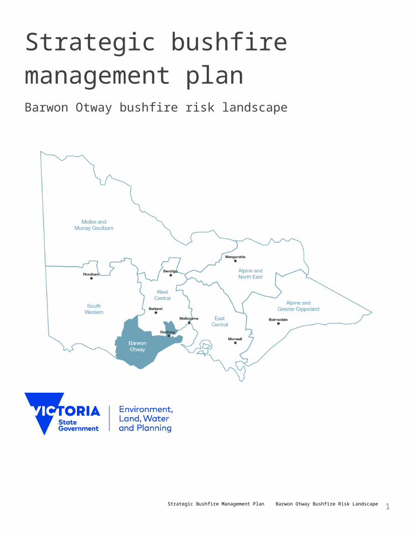
Strategic bushfire management plan Barwon Otway bushfire risk landscape
Strategic Bushfire Management Plan Barwon Otway Bushfire Risk Landscape 1
© The State of Victoria Department of Environment, Land, Water and Planning 2015
This work is licensed under a Creative Commons Attribution 4.0 International licence. You are free to re-use the work under that licence, on the condition that you credit the State of Victoria as author. The licence does not apply to any images, photographs or branding, including the Victorian Coat of Arms, the Victorian Government logo and the Department of Environment, Land, Water and Planning (DELWP) logo. To view a copy of this licence, visit http://creativecommons.org/licenses/by/4.0/
Printed by Impact Digital, Brunswick.
ISBN 978-1-74146-873-1 (Print)
ISBN 978-1-74146-874-8 (pdf)
Disclaimer
This publication may be of assistance to you but the State of Victoria and its employees do not guarantee that the publication is without flaw of any kind or is wholly appropriate for your particular purposes and therefore disclaims all liability for any error, loss or other consequence which may arise from you relying on any information in this publication.
Accessibility
If you would like to receive this publication in an alternative format, pleasetelephone the DELWP Customer Service Centre on 136186, [email protected], or via the National Relay Service on 133 677www.relayservice.com.au. This document is also available on the internet atwww.delwp.vic.gov.au.
Strategic Bushfire Management Plan Barwon Otway Bushfire Risk Landscape 2
ForewordThis plan is the first strategic bushfire management plan for the Barwon Otway bushfire risk landscape. It marks the beginning of a new, strategic, risk-based approach to bushfire management on public land that was recommended by the Victorian Bushfires Royal Commission after the 2009 Black Saturday bushfires.The Royal Commission was the catalyst for the Victorian Government to improve how emergency management systems work for communities. This plan—and the strategic bushfire management planning process through which it was developed—improves how Department of Environment, Land, Water and Planning (DELWP) and Parks Victoria (PV) work together with the community, industries and other emergency services agencies to build a safer and more resilient Victoria.The Victorian Government is committed to managing and reducing risks to life, property, infrastructure and local economies from the impact of major bushfires, and to enhancing the resilience of our natural ecosystems. To do this, we are bringing together for the first time the best available science, cutting-edge bushfire simulation software and the extensive expertise of Victorian bushfire management specialists.We are supplementing this expertise with the wisdom of local communities, to draw on their knowledge and experience, understand what they value and how they see bushfire risk, and engage them in planning the best course of action. We thank all those who have given their time to contribute to the process of preparing this plan, including staff and representatives of our department, PV, Country Fire Authority (CFA), Victoria Police, local governments, water corporations, utility services, private land managers and communities in the landscape.It is important to note that the international standards for risk management, with which our strategic planning approach complies, accept that risk can never be completely eliminated. Bushfires will still occur each summer and everyone needs to be prepared and ready to respond. Bushfire risk can be managed, and its impacts minimised, with a high-quality risk management approach.Strategic planning is important; it builds a shared understanding of bushfire risk, and the options available to reduce the risk. This understanding empowers everyone in Victoria to work in partnership, to tackle the threat of future bushfires.Implicit in a high-quality approach is a commitment to continuous improvement. The processes used to develop this plan are an improvement on what has gone before, and bushfire management will continue to evolve with advances in science, technology and how we engage with the community. Through this plan we set clear directions that will guide our bushfire management operations. Our activities will focus on reducing bushfire risk – this is how we will know we’ve been successful.
Alan GoodwinDELWP Chief Fire Officer Helen Vaughan DELWP Regional Director Barwon South West
Strategic Bushfire Management Plan Barwon Otway Bushfire Risk Landscape 3
IntroductionThis plan is the strategic bushfire management plan for the Barwon Otway bushfire risk landscape. It explains the fuel management strategy and other actions that we—the Department of Environment, Land, Water and Planning (DELWP) and Parks Victoria (PV)—will undertake to minimise the impact of major bushfires on people, property, infrastructure and economic activity, and maintain and improve the resilience of natural ecosystems. This plan replaces the Otway Fire District, Fire Protection Plan (2003).Under the Forests Act 1958, DELWP is responsible for bushfire risk management on the land it and PV manage, and on protected public land as described in the Act. We manage more than seven million hectares of public land on behalf of all Victorians. Our bushfire risk management work ranges from strategic planning to reduce bushfire risk, through to on-ground operations (such as managing vegetation that could fuel a bushfire, coordinating emergency responses to bushfires, and helping communities recover from them).The Victorian Government’s Emergency Management Reform White Paper emphasises that emergency management, of which bushfire risk management is a component, is a shared responsibility of the whole community. DELWP and PV work with other public sector agencies (including Country Fire Authority [CFA], Victoria Police and State Emergency Service), local governments, water corporations, utility services, private land managers and Victorian communities, to reduce bushfire risk on public and private land in one of the most bushfire-prone areas in the world.Established under the Conservation Forests and Lands Act 1987, the Code of Practice for Bushfire Management on Public Land 2012 spells out how we will manage bushfire risk on public land. The code’s two primary objectives are to:• minimise the impact of major bushfires on human life, communities, essential and community infrastructure,
industries, the economy and the environment: human life will be afforded priority over all other considerations• maintain or improve the resilience of natural ecosystems and their ability to deliver services such as biodiversity,
water, carbon storage and forest products.The code requires DELWP and PV to prepare landscape-levelstrategic bushfire management plans to achieve the objectives, using a transparent, risk-based process based on scientific evidence and local knowledge. The code also includes outcomes, strategies and actions for prevention, preparedness, fuel management (including planned burning), response, recovery and monitoring, evaluation and reporting.We developed this plan in the context of Victoria’s new emergency management arrangements. The Victorian Government’s Emergency Management Reform White Paper and subsequent legislation aim to build community resilience through increased participation and shared responsibility. This plan helps achieve that aim by:• pairing local knowledge with world-leading technology
to simulate how bushfires behave• working with communities, industries and other stakeholders to understand what they value and want
to protect from bushfires• identifying the most effective options to reduce bushfire risk• monitoring, evaluating and reporting how bushfire risk has been reduced.To find out about the large body of research and analysis that underlies this plan, or how to be involved in activities to review and update this plan in future, go to www.delwp.vic.gov.au.
Strategic Bushfire Management Plan Barwon Otway Bushfire Risk Landscape 4
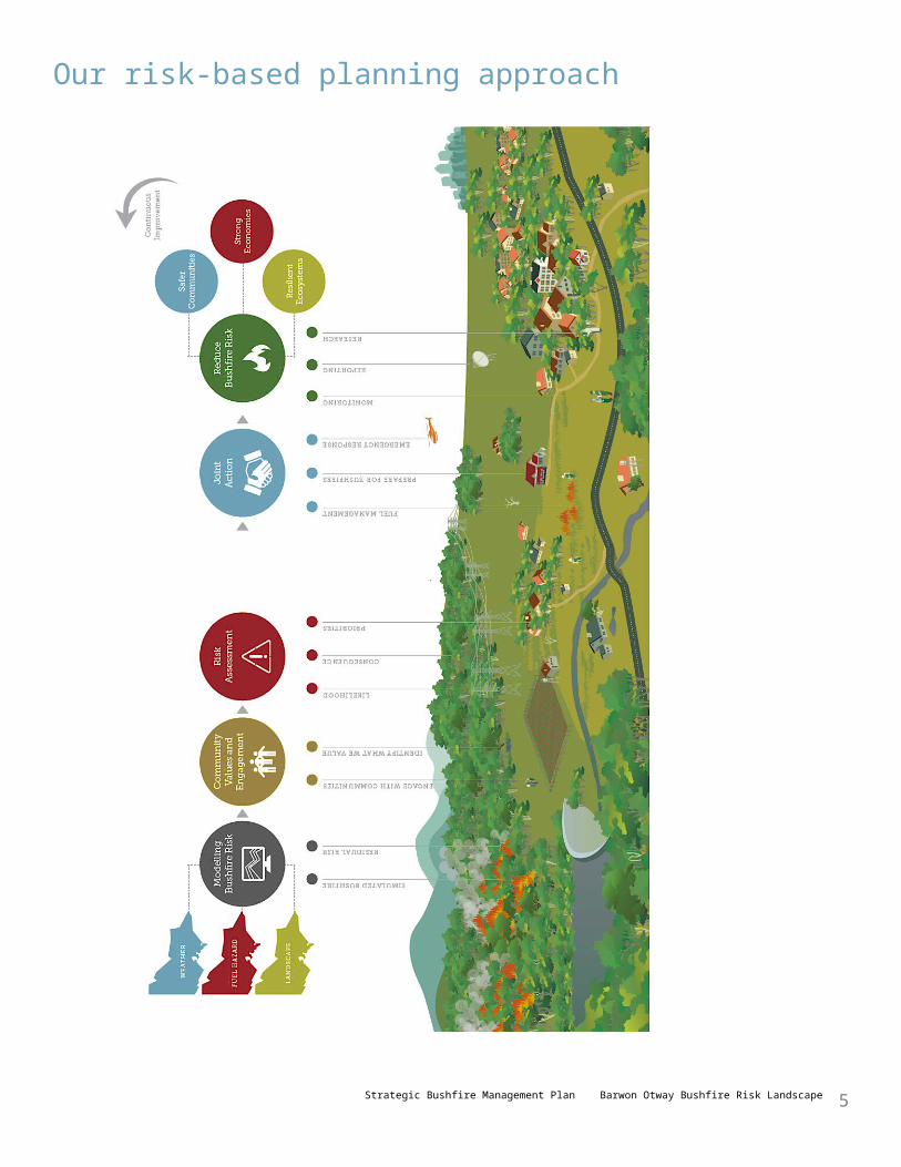
Our risk-based planning approach
Strategic Bushfire Management Plan Barwon Otway Bushfire Risk Landscape 5
Simulating bushfire riskWe can simulate bushfires at many scales: state, landscape or local. For strategic bushfire management planning purposes, DELWP and PV divide Victoria into seven bushfire risk landscapes. These are areas where bushfire behaviour is sufficiently common to treat the area as a whole. Bushfire behaviour includes the types of places that bushfires start, the terrain and vegetation through which they spread, and the types of impact they have.We use PHOENIX Rapidfire bushfire simulation software, that the University of Melbourne and the Bushfire Co-operative Research Centre developed in conjunction with DELWP, to simulate the spread and intensity of bushfires. The software predicts how bushfires spread from a range of ignition points, based on factors like vegetation, weather and terrain. It also helps us understand bushfire behaviour characteristics such as flame height, ember density, spotting distance and convection column strength and intensity. Comparisons between PHOENIX Rapidfire simulations and actual past bushfires show it accurately calculates their spread and intensity. This gives us confidence to simulate any weather scenario to measure future bushfire risk, to guide the development of bushfire management plans.Map 1 compares the extent of the 1983 Deans Marsh Ash Wednesday bushfire with the extent simulated by PHOENIX Rapidfire, using 1983 fuel hazard levels and worst-case bushfire weather. The simulation shows the extent after 24 hours: the actual extent is the bushfire’s final perimeter. The map also shows simulated flame heights, which indicate the intensity of the bushfire.The map shows the accuracy of PHOENIX Rapidfire’s simulation of the location and extent of the bushfire. The differences between the actual and simulated bushfire extent are due to firefighters successfully controlling the actual bushfire by back burning in some areas, the actual bushfire burning longer than 24 hours in some areas, and on some local fire dynamics that the software does not account for.
Bushfire scenariosPHOENIX Rapidfire simulation is based on worst-case bushfire weather, measured using the Forest Fire Danger Index (FFDI) which accounts for dryness (based on rainfall and evaporation), wind speed, temperature and humidity. The higher the FFDI, the more extreme the bushfire weather. On Black Saturday 2009—a day of extreme bushfire weather—the FFDI was recorded at over 130, which is the value DELWP uses for PHOENIX Rapidfire simulation of bushfire scenarios. History tells us a handful of extreme bushfires occurring on days when the FFDI is higher than 100 have caused the greatest losses of human life, although any bushfire (including those when the FFDI is much lower than 100) can destroy properties and claim lives.PHOENIX Rapidfire also lets us nominate the fuel hazard—the structure and amount of burnable vegetation—at any particular place. By altering the amount of vegetation in the landscape, we can use PHOENIX Rapidfire to simulate how fuel management may alter the behaviour of bushfires on days with FFDI 130.
Residual riskIf there has been no fire—bushfire or planned burning —at a place, there is maximum fuel hazard. By reducing the amount of vegetation in places that bushfires are likely to start, spread and impact, we can test the effectiveness of different fuel management strategies. The Victorian Bushfire Risk Profiles report has more information about how we use the PHOENIX Rapidfire bushfire simulation software to simulate bushfires and test fuel management strategies.When there is maximum fuel hazard, there is maximum risk a bushfire will damage or destroy a property or piece of infrastructure. Bushfires, and our fuel management strategy, reduce fuel hazard and so reduce bushfire risk. The remaining risk is called the residual risk and PHOENIX Rapidfire can calculate it across Victoria, a whole landscape, or one or more locations.
Strategic Bushfire Management Plan Barwon Otway Bushfire Risk Landscape 6
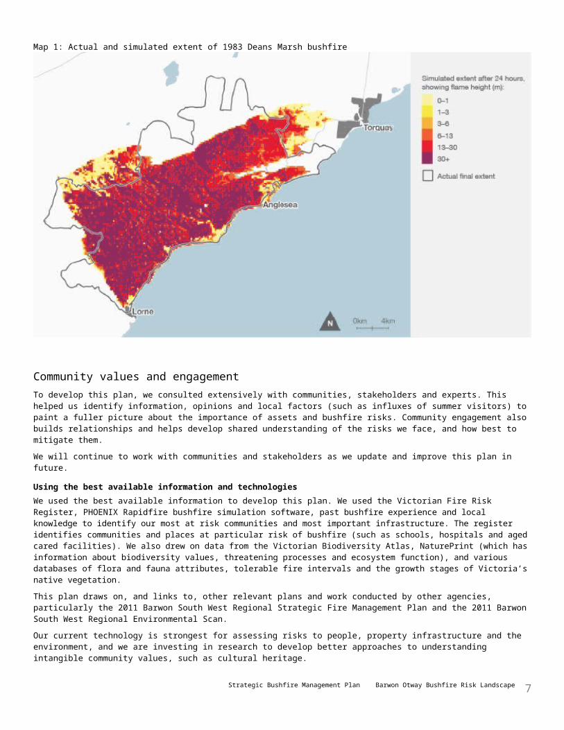
Map 1: Actual and simulated extent of 1983 Deans Marsh bushfire
Community values and engagementTo develop this plan, we consulted extensively with communities, stakeholders and experts. This helped us identify information, opinions and local factors (such as influxes of summer visitors) to paint a fuller picture about the importance of assets and bushfire risks. Community engagement also builds relationships and helps develop shared understanding of the risks we face, and how best to mitigate them.We will continue to work with communities and stakeholders as we update and improve this plan in future.
Using the best available information and technologiesWe used the best available information to develop this plan. We used the Victorian Fire Risk Register, PHOENIX Rapidfire bushfire simulation software, past bushfire experience and local knowledge to identify our most at risk communities and most important infrastructure. The register identifies communities and places at particular risk of bushfire (such as schools, hospitals and aged cared facilities). We also drew on data from the Victorian Biodiversity Atlas, NaturePrint (which has information about biodiversity values, threatening processes and ecosystem function), and various databases of flora and fauna attributes, tolerable fire intervals and the growth stages of Victoria’s native vegetation.This plan draws on, and links to, other relevant plans and work conducted by other agencies, particularly the 2011 Barwon South West Regional Strategic Fire Management Plan and the 2011 Barwon South West Regional Environmental Scan.Our current technology is strongest for assessing risks to people, property infrastructure and the environment, and we are investing in research to develop better approaches to understanding intangible community values, such as cultural heritage.
Identifying what’s most importantBased on our best available information we identify the most important property, infrastructure and economic assets in the landscape: major bushfires have resulted in millions of dollars damage to the agriculture, horticulture, viticulture, timber harvesting, tourism and retail industries, among others. We also identify our most important native vegetation and threatened species and how we can protect them from bushfire damage, and improve their resilience, through fuel management.
Strategic Bushfire Management Plan Barwon Otway Bushfire Risk Landscape 7
Risk assessmentOur methodology for developing this plan is based on the International Standard for Risk Management, ISO 31000. The risk assessment process aims to determine the likelihood and consequence of a major bushfire impacting on people and properties, on the landscape’s key infrastructure, economic assets and high-value ecosystem areas.
LikelihoodUsing PHOENIX Rapidfire, we develop maps of where bushfires might start, and how they might spread in worst-case bushfire weather, to estimate the likelihood of impacts occurring.
ConsequenceWe assess the consequences of a major bushfire by considering its intensity, speed, size and duration. We also assess how vulnerable a town, piece of infrastructure, economic asset or environmental asset is to fire, and whether it will recover quickly or slowly after a fire. Some factors may make particular communities or groups more vulnerable to bushfire (such as a lack of bushfire experience or high levels of disability).
PrioritiesWe prioritise for protection for a town, piece of infrastructure, economic asset or environmental asset if there is a strong likelihood that a major bushfire would impact on it, and there would be severe consequences if it did. We will protect those things at highest risk through the mitigation actions in this plan.
Joint actionManaging bushfire risk is a responsibility we share with other public sector agencies, land managers and the community.The Victorian Government’s Emergency Management Reform White Paper aims to build community resilience through increased participation and shared responsibility. It is reforming the emergency management sector over the next few years, starting with the Emergency Management Act 2013. The Act, among other things, establishes new institutions to ensure that Victoria is well-prepared to deal with emergencies when they occur.The establishment of Emergency Management Victoria and other initiatives will improve how DELWP and PV work collaboratively with other agencies, stakeholders and the community to reduce the risk of bushfires and other emergencies and promote a safer and more resilient Victoria. This ‘all hazards, all agencies’ approach to emergency management improves our strategic bushfire management planning, and increases our sharing of information about bushfire behaviour and risk with our partners. This gives us all a common operating picture, improving our joint actions.We will continue to work in partnership with the Emergency Management Commissioner, the CFA, local governments and water corporations to reduce bushfire risks on public land. We also work with other agencies, and with private land managers, to reduce risks on private land and to encourage residents and land owners to find out about bushfire risks on their property and have an up-to-date fire ready plan.
Managing fuel hazardOur fuel management strategy for this landscape involves reducing the quantity of leaf litter, twigs, bark and undergrowth by planned burning and mechanical methods. The strategy identifies locations where fuel management will help to keep fires small where they start, or reduce the spread of bushfires, to minimise their impact on life and property, and maintain or improve the resilience of natural ecosystems.Through fuel management, DELWP has already significantly reduced bushfire risk in our landscape.
Prevention, preparedness, response and recoveryThe code of practice emphasises the importance of using a range of prevention, preparedness, fuel management, response and recovery strategies and actions to reduce bushfire risk.Prevention actions minimise the occurrence of bushfires, particularly those started by people, when weather conditions are extreme. We must be adequately prepared for bushfires, to improve our response to them when they occur. DELWP is responsible for suppressing bushfires in state forests, national parks and protected public land, and for the recovery of public land after a bushfire.
Continuous improvementDELWP is soon to release the Monitoring, Evaluation and Reporting Framework for Bushfire Management on Public Land, which will guide how we assess the effectiveness of our management strategies and activities across Victoria in
Strategic Bushfire Management Plan Barwon Otway Bushfire Risk Landscape 8
achieving the two code of practice objectives.
Monitoring and evaluationThis plan outlines broad monitoring and evaluation priorities we will use to measure how effectively our fuel management strategy and other actions minimise the impact of major bushfires on life and property and maintain or improve the resilience of natural ecosystems. We will develop a monitoring and evaluation plan for our landscape to guide the implementation of this plan.
ReportingWe will make regular public reports of monitoring and evaluation findings, to promote transparency and accountability and to ensure the community has current information about bushfire risk.
ResearchUnder DELWP’s Bushfire Science Strategy 2013–17, we will invest in research to improve the information available for future planning.
ReviewWe will regularly review and revise the strategies and actions in this plan, as bushfire technology and science advance, to respond to changes in bushfire risk, the things communities value, and community and stakeholder needs. We emphasise our commitment to engaging stakeholders and communities in reviews and revisions of this plan.
Strategic Bushfire Management Plan Barwon Otway Bushfire Risk Landscape 9
Bushfires and Barwon Otway
About our bushfire risk landscapeThe Barwon Otway bushfire risk landscape is in south-west Victoria. Map 2 shows it extends north to Skipton, south to Cape Otway, east to Queenscliff and west to Port Campbell. The landscape includes the City of Greater Geelong, the Borough of Queenscliff, Surf Coast Shire, Colac Otway Shire and Corangamite Shire.The landscape is 1,065,300 ha, which is 5% of the state's area. Of this:• 48,500 ha is public land managed by DELWP (4.6% of the total landscape)• 143,900 ha is public land managed by PV (13.5%)• 46,300 ha is other public land (4.3%)• 826,600 ha is private land (77.6%).The Barwon Otway landscape has 20% of Victoria's total bushfire risk to lives and properties. This reflects the landscape’s high population density close to forests. Of Victoria's seven bushfire risk landscapes, ours has the second-most amount of risk. The Victorian Bushfire Risk Profiles report describes how bushfire risk to properties is calculated and distributed across the state.The Otway Ranges are the landscape's main geographic feature, and contain the state's westernmost extent of tall wet forest. North of the ranges' forests are plains, which become drier as they extend north. South of the ridge, to the coast, is mostly forested and much wetter. To the east, the Anglesea heathland dominates, with one of the state’s most diverse ecosystems. It's a highly productive landscape, with higher rainfall than many other parts of Victoria. It has a diverse mix of coastal, mountain and farm communities and areas, and diverse ecosystems.The Great Ocean Road, an Australian tourist icon and an important transport route, extends across the landscape.
How our worst bushfires behaveIn worst-case bushfire weather, north-westerly winds bring hot, dry air from central Australia to raise Victoria's temperature above 40°. Then, cold fronts, often with little rain, swing the wind to the south-west, initially at strong to gale force. These conditions can create bushfires with powerful convection columns. Ember storms, wind-blown debris, downbursts, fire tornadoes and explosive flares of igniting eucalyptus vapour are common. This was the weather on 16 February 1983 (Ash Wednesday) and 7 February 2009 (Black Saturday).Bushfires in our landscape are not usually as protracted as they can be in the forests of eastern Victoria, and the main damage occurs on the first day.Many of the most damaging bushfires in our landscape started in the grasslands north of the Otway Ranges, then quickly moved into the forest. In 1983, the Ash Wednesday Deans Marsh bushfire moved from the grasslands in the north to the coast in an afternoon.The north-west-facing foothills and lower slopes of the Otway Ranges face the prevailing bushfire weather wind direction. Vegetation on these slopes, and along the Gellibrand River valley, provides fuel for bushfires to rapidly develop and spread. Initially, most bushfires travel rapidly in a south-east direction ahead of the strong north-westerly pre-frontal winds. Then, as strong south-westerly winds set in behind cold fronts, bushfires may quickly spread from their broad north-east flank through the heathlands, grassy/heathy dry forest and coastal scrub along the coastline, and the heathlands around Anglesea.
Our major bushfiresThere have been many destructive bushfires in the Barwon Otway landscape. Table 1 shows the major bushfires in our landscape since 1851. It shows how devastating the 1983 Ash Wednesday bushfires were in the Otways. The potential for similar bushfires exists, and will continue to exist into the future.
Strategic Bushfire Management Plan Barwon Otway Bushfire Risk Landscape 10

Map 2: Barwon Otway bushfire risk landscape
Strategic Bushfire Management Plan Barwon Otway Bushfire Risk Landscape 11
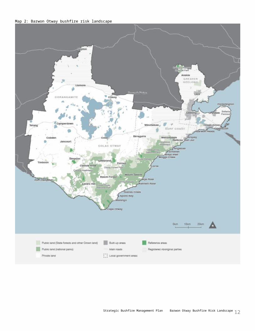
Table 1: Major bushfires in Barwon Otway since 1851Year Location Size (ha) Losses
1851 Otways (Black Thursday) Unknown 1 person
1901 Birregurra Unknown 6 people
1908 Anglesea Unknown 7 houses
1908 Beech Forest, Mt Sabine Unknown 3 people
1919 Beech Forest, Otways 32,375 3 people
1934 Otways Unknown 11 houses
1939 Otways (Black Friday) 240,000 4 people, 9 sawmills, multiple buildings
1940 Torquay Unknown 1 person, 90 houses, 10 other buildings
1951 Otways 4586 Unknown
1951 Lorne 2248 Unknown
1962 Wye River Unknown 7 houses
1965 Benwerrin (Lorne) 2800 4 houses
1966 Wensleydale, Lorne, Anglesea 3200 + 14 houses
1982 Fairhaven Unknown 2–3 houses
1983 Otways (Ash Wednesday) 42,000 3 people, 729 houses
1985 Anakie, Little River 8700 2 people
2006 Anakie, Brisbane Ranges 6798 5 houses
October–April is bushfire seasonIn the 20 bushfire seasons to 2013–14, DELWP responded to an average of 20 bushfires a year in our landscape, although the actual number each season varied substantially according to the dryness of the season. For example, 2010–11 had a relatively wet summer, and there were only six bushfires. 1997–98 was a hot, dry summer, and there were 43 bushfires. CFA responded to many more bushfires on private property that aren’t included in these figures.Over the 20 seasons, DELWP has suppressed 79% of the bushfires it attended in our landscape before they grew to 5 ha. Our capability to quickly suppress bushfires before they grow to a size and intensity that makes them difficult to control is a core part of our approach to reducing bushfire risk.
How bushfires start
Strategic Bushfire Management Plan Barwon Otway Bushfire Risk Landscape 12

In the decade to 2014, the biggest cause of bushfires in our landscape that DELWP responded to (43%) was accidents by people: these bushfires were started by causes including machinery, trains and escapes from campfires and burn offs. Deliberate action by people accounted for 17% of bushfires, lightning 19% and the remainder (21%) had other or unknown causes.
Using residual risk to measure our successDELWP uses the idea of ‘residual risk’ to assess whether activities such as fuel management are reducing bushfire risk.Residual risk is the risk, on average and across the whole landscape, that bushfires will impact a property or other assets. It is the percentage of risk that remains after past bushfires and fuel management (mainly planned burning) are taken into account. For example, 80% residual risk means that the risk of property or other assets being impacted by a bushfire—on average, throughout the landscape—is 80% of what it would have been if we had never had bushfires or planned burning to reduce the fuel hazard.DELWP measures residual risk using PHOENIX Rapidfire bushfire simulation software. This software calculates the reduction in a location’s residual risk if we reduce fuel hazard at the ignition points, and along the spread paths, of bushfires that could impact the location. This gives us the information to manage fuel where it offers the greatest reduction in residual risk. It also helps us minimise the environmental impacts of our planned burning activities because we can better choose where to burn, and at what intensity.DELWP reports the residual risk of bushfires in its annual fuel management report. The trend in this number, over time, indicates whether our activities are helping reduce bushfire risk.Figure 1 shows how bushfires and our planned burning have affected residual risk in the Barwon Otway landscape since 1980. It shows that residual risk increased in the 15–20 years after the 1983 Ash Wednesday bushfires, as vegetation slowly grew back, from around 30% to almost 90%. After 2007, more (and more strategic) fuel management, informed by risk analysis, resulted in a sharp drop in residual risk, to around 60% in 2013. The figure also shows the hectares burnt by bushfires, and by planned burning, in each year.Residual risk comprises risk on both public and private land. Safe and efficient burning of some areas of public land needs to be done in conjunction with private landholders, if there is continuous forest across the public-private land boundary.
Projections for our future climateLong-term records show an increase in bushfire danger and the length of the bushfire season for Victoria in recent decades. Projections for Victoria’s future climate indicate that the frequency and intensity of bushfires in south-east Australia will continue to increase. Projections also include:• reduced average rainfall and streamflows• fewer and heavier rainfall days and more consecutive
dry days• an increase in the extent and frequency of droughts• more days over 35° and a higher annual mean temperature• an increase in the number of extreme fire danger days (with FFDI greater than 75), by between 15% and 70%
by 2050.The precise impacts of climate change on the landscape’s flora and fauna are not known, but are likely to include the arrival of species to new areas in the landscape, altered fire regimes and altered hydrology. Climate change is likely to change the attributes and availability of habitat, which will pose a particular threat to species that are isolated in the landscape, or have little ability to relocate to more suitable habitat.PHOENIX Rapidfire simulations can be done for any weather scenario, including extreme weather conditions. We can therefore use it to assess bushfire risk resulting from changes in our climate over time.
Strategic Bushfire Management Plan Barwon Otway Bushfire Risk Landscape 13
Figure 1: Residual risk, 1980–2013
Strategic Bushfire Management Plan Barwon Otway Bushfire Risk Landscape 14

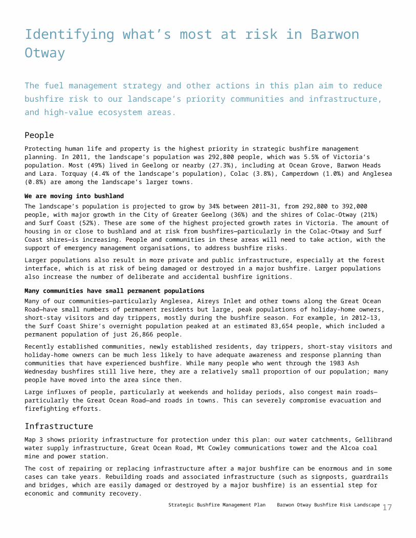
Identifying what’s most at risk in Barwon Otway
The fuel management strategy and other actions in this plan aim to reduce bushfire risk to our landscape’s priority communities and infrastructure, and high-value ecosystem areas.
PeopleProtecting human life and property is the highest priority in strategic bushfire management planning. In 2011, the landscape’s population was 292,800 people, which was 5.5% of Victoria’s population. Most (49%) lived in Geelong or nearby (27.3%), including at Ocean Grove, Barwon Heads and Lara. Torquay (4.4% of the landscape’s population), Colac (3.8%), Camperdown (1.0%) and Anglesea (0.8%) are among the landscape’s larger towns.
We are moving into bushlandThe landscape’s population is projected to grow by 34% between 2011–31, from 292,800 to 392,000 people, with major growth in the City of Greater Geelong (36%) and the shires of Colac-Otway (21%) and Surf Coast (52%). These are some of the highest projected growth rates in Victoria. The amount of housing in or close to bushland and at risk from bushfires—particularly in the Colac-Otway and Surf Coast shires—is increasing. People and communities in these areas will need to take action, with the support of emergency management organisations, to address bushfire risks.Larger populations also result in more private and public infrastructure, especially at the forest interface, which is at risk of being damaged or destroyed in a major bushfire. Larger populations also increase the number of deliberate and accidental bushfire ignitions.
Many communities have small permanent populationsMany of our communities—particularly Anglesea, Aireys Inlet and other towns along the Great Ocean Road—have small numbers of permanent residents but large, peak populations of holiday-home owners, short-stay visitors and day trippers, mostly during the bushfire season. For example, in 2012–13, the Surf Coast Shire’s overnight population peaked at an estimated 83,654 people, which included a permanent population of just 26,866 people.Recently established communities, newly established residents, day trippers, short-stay visitors and holiday-home owners can be much less likely to have adequate awareness and response planning than communities that have experienced bushfire. While many people who went through the 1983 Ash Wednesday bushfires still live here, they are a relatively small proportion of our population; many people have moved into the area since then.Large influxes of people, particularly at weekends and holiday periods, also congest main roads—particularly the Great Ocean Road—and roads in towns. This can severely compromise evacuation and firefighting efforts.
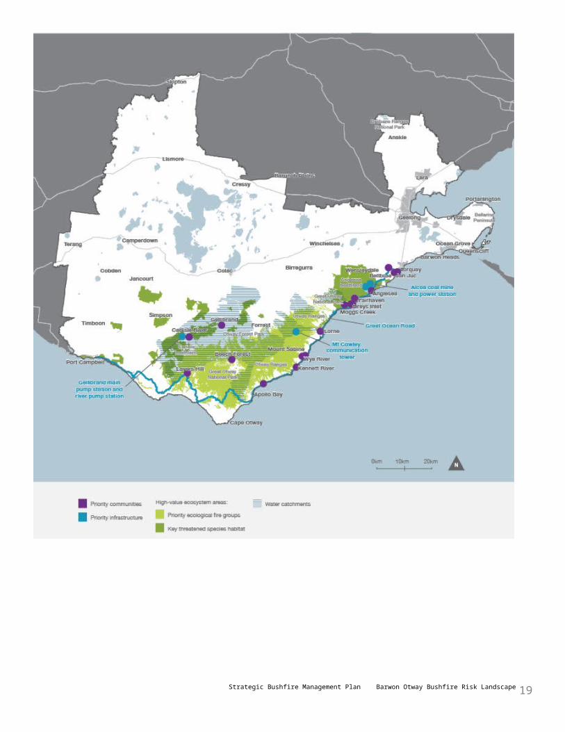
InfrastructureMap 3 shows priority infrastructure for protection under this plan: our water catchments, Gellibrand water supply infrastructure, Great Ocean Road, Mt Cowley communications tower and the Alcoa coal mine and power station.The cost of repairing or replacing infrastructure after a major bushfire can be enormous and in some cases can take years. Rebuilding roads and associated infrastructure (such as signposts, guardrails and bridges, which are easily damaged or destroyed by a major bushfire) is an essential step for economic and community recovery.
Power infrastructureWhile there is only a small risk of a bushfire damaging or destroying a high-voltage power line, even a short-term disruption can be regionally significant during a heatwave or major bushfire. Several smaller distribution lines serving communities such as Gellibrand, Forrest, Lorne and Apollo Bay that pass through forested areas are at risk from bushfires.Alcoa’s Anglesea power station and coal mine are potentially at risk: coal ignites easily and coal fires are hard to suppress.
Water supply infrastructureThere are two water corporations in the landscape: Barwon Water (which supplies some 300,000 people, increasing to over 500,000 people over the summer holiday period) and Wannon Water (which supplies about 70,000 people in the landscape with water from north and south Otway pipelines). Both corporations have many more customers over the summer holiday period, and have large commercial customers including exporting dairy manufacturers and food processors. They work with fire agencies and invest each year to mitigate bushfire risks and fight fires in their catchments.
Strategic Bushfire Management Plan Barwon Otway Bushfire Risk Landscape 15

Bushfires can damage or destroy vital water supply infrastructure such as treatment plants, pumping stations and pipeline networks. Bushfire debris, ash and soil erosion can contaminate rivers and streams that feed into water supply catchments and disable infrastructure. A major bushfire that burns ash forest can reduce a catchment’s yield for up to 150 years, as the forest grows back, stabilises the soil and filters run-off. Barwon Water estimates there would be a loss of up to 14% of our water in the event of a major bushfire in the West Barwon catchment.If a major bushfire damages a catchment or supporting infrastructure in the Otway Ranges, there are other sources of supply, including large off-site storages and linked pipelines to other supply areas. Water corporations can turn off affected catchments, and water can be extracted from bores. However, some Otway Ranges catchments—such as the Arkins catchment, Painkalac Creek (which supplies Aireys Inlet and Fairhaven) and St Georges River (which supplies Lorne)—are single-source catchments, which means there are no other readily available sources of water for these communities. Painkalac Dam had a significant build-up of debris after the 1983 Ash Wednesday bushfires.
Map 3: Priority communities and infrastructure, and high-value ecosystem areas
Strategic Bushfire Management Plan Barwon Otway Bushfire Risk Landscape 16
Strategic Bushfire Management Plan Barwon Otway Bushfire Risk Landscape 17

EnvironmentAbout our native vegetationThe Otway Ranges have most of the landscape’s native vegetation, which extends intact from Anglesea to Cape Otway. There are also small patches around Timboon, Jancourt and Port Campbell in the west, and in the Brisbane Ranges in the north-east. Most native vegetation on public land is in the Great Otway National Park, Port Campbell National Park, Otway Forest Park, Anglesea heathland, parts of the Brisbane Ranges National Park and the You Yangs Regional Park.
Ecological fire groupsThe landscape has 23 ecological fire groups (EFGs). EFGs are groupings of the more commonly known ecological vegetation classes that have common ecological requirements for fire, and common fire behaviour characteristics. EFGs are a useful way of classifying native vegetation when developing a fuel management strategy.The important EFGs in our landscape are:• moist forest, tall mist forest, closed forest and riparian forest, covering 120,743 ha in wetter and higher-altitude areas
of the Otway Ranges• tall mixed forest, forby forest, grassy/heathy dry forest and heathland, covering 120,565 ha of drier and lower-altitude
areas on the northern and southern slopes of the Otway Ranges• damp scrub and coastal scrub, covering 15,504 ha closer to the coast• basalt grassland, western plains woodland and inland plains woodland, covering 33,418 ha in central and northern
parts of the landscape.
Ecosystem resilience, tolerable fire intervals and vegetation growth stagesAn ecosystem’s resilience is its capacity to withstand and recover from a range of disturbances, including fire. We cannot measure ecosystem resilience by looking at a single species or fire event: we must look at the whole landscape, and at multiple fires with various frequencies, intensities, scales and seasons of burning.Tolerable fire intervals (TFIs) are the minimum and maximum recommended times between fire events for a particular EFG. Burning regularly outside these intervals increases the risk that there will be fundamental changes in the abundance and composition of species, and the type of vegetation.We use TFIs as an initial surrogate measure of risk to ecosystem resilience across the landscape, and as an input to decisions about how often, when and where to conduct planned burning.The growth stage of vegetation depends on when it was last burnt, or subject to other disturbance. Each vegetation type passes through distinct stages following disturbance, each stage differing in the quality of the habitat it provides for plants and animals. Lack of diversity of growth stages in a landscape may reduce the ecosystem’s capacity to resist damage and maintain its basic structure and type, after being disturbed by fire. DELWP is working toward using vegetation growth stages to help measure ecosystem resilience.
Threatened species and ecological communitiesOf the 1708 native flora species and 631 native fauna species recorded in the landscape, 47 flora and 91 fauna species are listed as threatened under the Flora and Fauna Guarantee Act 1988 and 30 flora and 40 fauna species are listed under the Environment Protection and Biodiversity Conservation Act 1999. Some species are listed under one or both Acts. Both Acts require DELWP and PV to ensure our activities (including fuel management activities) do not have a significant impact on threatened species and communities.The landscape has 12 species which are a priority for strategic bushfire planning, based on their vulnerability or sensitivity to fire. They are the long-nosed potoroo, powerful owl, southern brown bandicoot, swamp antechinus, white-footed dunnart, ground parrot, New Holland mouse, rufous bristlebird, diamond firetail, swamp skink, chestnut-rumped heathwren and Anglesea grevillea. Many other threatened species, such as highly localised orchids, are also important and DELWP mitigates risks to them through its fire operations plan and burn plans.Some species (such as rufous bristlebird, southern brown bandicoot, swamp antechinus and Anglesea grevillea) typically inhabit bushfire-prone heathy woodland close to towns. These species respond well to some fires, but large-scale, intense bushfires or prolonged, frequent fire (such as can occur with planned burning) may harm them.The landscape has six ecological communities listed under the Flora and Fauna Guarantee Act 1988 or the Environment Protection and Biodiversity Conservation Act 1999. These comprise mainly inland grassland and woodland communities in central and northern parts of the landscape, cool temperate rainforest in deep gullies in the Otway Ranges, and coastal moonah woodland along the Bellarine Peninsula coast.
Reference areasReference areas are relatively undisturbed tracts of public land proclaimed under the Reference Areas Act 1978. They serve as a reference for research to investigate the impacts and potential solutions to issues arising from land use and
Strategic Bushfire Management Plan Barwon Otway Bushfire Risk Landscape 18
management activities. There are 12 reference areas in the Barwon Otway landscape, totalling 7073 ha. This plan aims to maintain these areas in as natural a state as possible by reducing bushfire risk—provided it doesn’t compromise our ability to mitigate risk to life and property—and by using planned burning in an ecologically sensitive way.
EconomyEnterprises in the landscape employ over 123,000 people. The industries most affected by major bushfires are agriculture, horticulture and viticulture; timber harvesting; tourism; and retail and commercial.
Agriculture, horticulture and viticultureDairy, sheep and wool, cattle grazing, agroforestry and cropping enterprises abound on the agricultural land north of the Otway Ranges and on the Bellarine Peninsula. In Corangamite Shire, dairy farming alone employs 20.7% of all workers.Viticulture is a developing industry, mostly in the Surf Coast and Greater Geelong local government areas. There are 84 registered wineries in the landscape, mostly in the eastern Otways.Bushfires destroy agricultural and horticultural assets, such as buildings, fencing, machinery and equipment. They also kill and injure ivestock and destroy productive plants, such as fruit trees, grape vines and timber plantation resources.Smoke from fires can permeate through the skin of fruits. The viticulture industry is particularly vulnerable to smoke taint during the summer bushfire season and autumn planned burning periods, which are when fruit ripens. We aim to manage the risk of smoke taint by reducing the frequency and severity of bushfires, simulating the movement of smoke before starting planned burning in critical areas and at critical times, by consulting with grape growers about the timing of planned burning, and by continuing research into smoke taint.
Timber harvestingThe hardwood timber industry in the Otway Ranges dates from the 1880s, when the first large-scale sawmills were built. The creation of the Great Otway National Park and Otway Forest Park in 2008 saw the end of commercial timber harvesting in public forests, but the Otway Forest Park continues to provide areas where people can collect firewood.About 1% of our landscape is privately owned softwood and native hardwood plantations. These provide an important commodity for domestic and international markets. Bushfires can destroy these plantations and devastate this industry. The loss can continue for decades, as new plantations grow to harvesting age.Plantations are generally fragmented and are often adjacent or close to native forest. They can increase the bushfire risk across the landscape by providing continuity of fuel for bushfires as they spread.
TourismThe landscape’s tourism and recreation industry dates to before 1900, with the waterfalls and walking tracks around new settlements such as Beech Forest being popular attractions. Over the years, the region’s tourism profile has grown significantly in international and domestic markets.The Great Ocean Road is one of Australia’s iconic tourism destinations. It is on the National Heritage List and the Victorian Heritage Register. In 2010, the Great Ocean Road region had an estimated 7 million visitors, worth $1.1 billion to the Victorian community.The Great Otway National Park and Otway Forest Park continue to expand the eco-tourism and recreation markets with the Great Ocean Walk and Forrest Mountain Bike Trails significant drawcards to the Otway hinterland and coast.Bushfires damage or destroy the natural environments and infrastructure on which tourism industries rely. Bushfires, occurring as they usually do in the summer holiday months, can result in a dramatic drop in tourist numbers, with consequent economic losses. During and immediately after a major bushfire, would-be visitors generally stay away from burnt and nearby areas.
Retail and commercialThe retail, construction and manufacturing industries employ over 40,000 people in our landscape. Most jobs are in Geelong, but these sectors are important across the entire landscape.During and after a bushfire, retail trade drops as the local people evacuate their property; and they may not be able to quickly return. The number of tourists also drops. For example, businesses in bushfire-affected areas after the 2003 alpine bushfires reported a 50–70% downturn, and some reported no business at all. Those bushfires cost retail and commercial businesses in four shires $48 million over four months, about one-third of the shires’ gross product. As another example, the 2006–07 Great Divide bushfire cut power to 70,000 businesses, mostly in Melbourne and Geelong. Losses to households and businesses totalled $235
Strategic Bushfire Management Plan Barwon Otway Bushfire Risk Landscape 19
million, with indirect and flow-on costs a further $265 million.Bushfires can increase business in some industries. Firefighters and support personnel need food, water, accommodation and equipment. The construction industry also benefits when built assets are destroyed and must be replaced.
Cultural heritageThere are 3,213 registered Aboriginal cultural heritage sites in the landscape, resulting from a history of thousands of generations of Aboriginal people. The actual number of heritage sites in the landscape is almost certainly far greater. Sites include ceremonial gathering places, shell middens, burial sites, scar trees and artefact scatters. Sites are common along coastal areas and their surrounding dunes and cliffs, and close to rivers and streams. Various plants and animals are also culturally important to Aboriginal people, relating as they do to identity and social wellbeing.Intangible aspects of the landscape’s Aboriginal cultural heritage relate to spiritual, cultural and lifestyle connections to the environment and include stories, song lines, family links and trading patterns.
Aboriginal people used burning in open forests and grasslands over thousands of years to help them hunt, and to maintain the supply of food plants. Bushfire risk management can draw on the wisdom and experience of our Aboriginal cultural heritage and support Aboriginal people to rebuild and maintain connections to Country. The landscape’s Aboriginal cultural heritage is an important heritage of all Australians, and is of global significance.Wathaurung Aboriginal Corporation is currently the only registered Aboriginal party (RAP) in the landscape. Map 2 shows the Wathaurung RAP area. It covers the far eastern Otways, starting on the east side of Painkalac Creek toward Anglesea and extending across the Bellarine Peninsula and Geelong, and north of the Hamilton Highway into the West Central bushfire risk landscape.The Eastern Maar Aboriginal Corporation was appointed as a RAP in 2013. Its application covers an area running between Yambuk and Hamilton, to the west of Warrnambool. While the interests of the Eastern Maar people include land within the bushfire risk landscape boundary, this is not recognised by their current RAP appointment. The remainder of Eastern Maar’s RAP application is still being considered, and may in future include places within the landscape.Forest harvesting and timber production, mixed farming and agriculture, water supply, land transport, maritime industries and more recently tourism have all contributed to the non-Aboriginal cultural heritage of the landscape. The Cape Otway Lighthouse (built in the 1850s) and the Great Ocean Road (built between 1918–32) are two of the landscape’s most well-recognised landmarks. Sites such as sawmills, tramways and building remains reflect the landscape’s rich timber harvesting history. Along the coast there are also many examples of strong connections with maritime industries past and present.
Priority communities and high-value ecosystem areasIn worst-case bushfire weather, a bushfire can travel quickly across a large area of our landscape. To effectively manage bushfire risk, we simulate where the highest-impact bushfires are likely to start, spread and cause maximum damage to life and property. We can then reduce fuel hazard at the potential ignition points and along the spread paths of these highest-impact simulated bushfires, which will support last-line defence around priority assets. Knowledge of the most consequential ignition points also helps us decide where to preposition firefighting equipment and conduct patrols in worst-case bushfire weather.
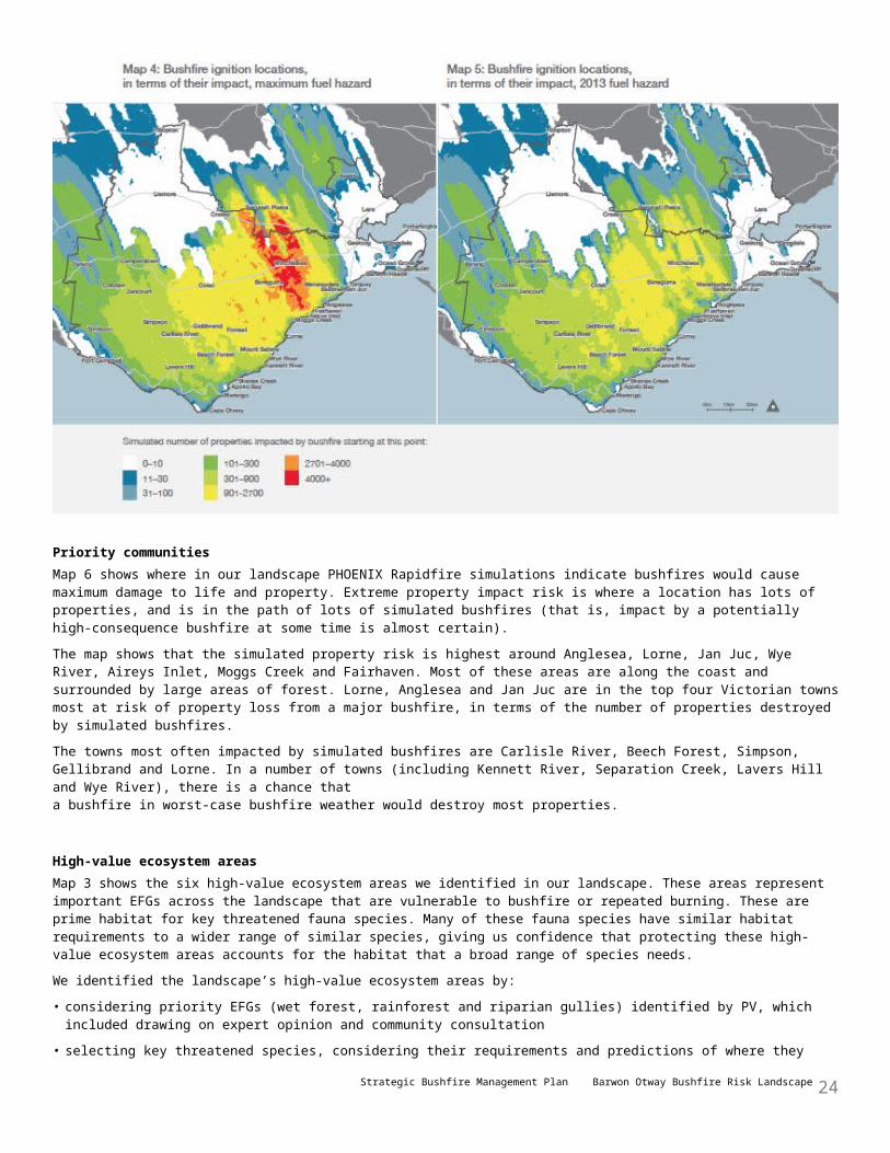
Map 4 shows where PHOENIX Rapidfire predicts bushfires would start that would destroy the greatest number of properties in Barwon Otway, given maximum fuel hazard (which is with no fuel reduction in the landscape, from bushfires, planned burning and other fuel management). Maximum fuel hazard is the benchmark against which we can measure the effectiveness of various fuel management scenarios in reducing bushfire risk. Red and orange show the starting points—not where properties would actually be impacted—for the greatest-impact bushfires: white the least.
Strategic Bushfire Management Plan Barwon Otway Bushfire Risk Landscape 20
Map 5 shows where PHOENIX Rapidfire predicts bushfires would start that would destroy the greatest number of properties in Barwon Otway, based on fuel hazard as it was in 2013. Comparing maps 5 and 4, we see that fuel reduction (through bushfires and fuel management) has reduced the potential impact of simulated bushfires that might start at the most-consequential ignition points. For example, with maximum fuel hazard (Map 4), a bushfire igniting around Winchelsea could potentially impact 4000 properties. With 2013 fuel hazard, this reduces to around 900 properties for almost all bushfires that might start anywhere in that area.Fires that result in the largest losses start in the grasslands and forests of the eastern Otway Ranges, and in the grasslands that stretch north to the Hamilton Highway. In this area, most damaging bushfires start in a relatively tight band running from Aireys Inlet in the south, through Wensleydale and Winchelsea to Barunah Plains in the north.
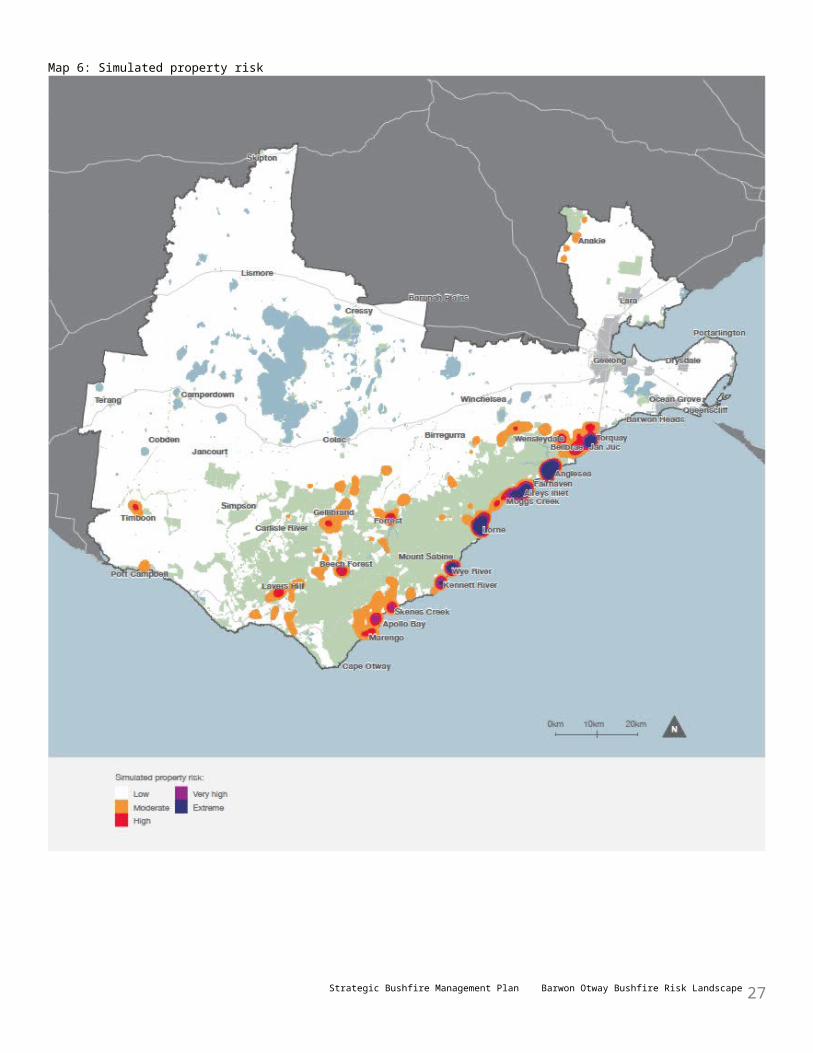
Priority communitiesMap 6 shows where in our landscape PHOENIX Rapidfire simulations indicate bushfires would cause maximum damage to life and property. Extreme property impact risk is where a location has lots of properties, and is in the path of lots of simulated bushfires (that is, impact by a potentially high-consequence bushfire at some time is almost certain).The map shows that the simulated property risk is highest around Anglesea, Lorne, Jan Juc, Wye River, Aireys Inlet, Moggs Creek and Fairhaven. Most of these areas are along the coast and surrounded by large areas of forest. Lorne, Anglesea and Jan Juc are in the top four Victorian towns most at risk of property loss from a major bushfire, in terms of the number of properties destroyed by simulated bushfires.The towns most often impacted by simulated bushfires are Carlisle River, Beech Forest, Simpson, Gellibrand and Lorne. In a number of towns (including Kennett River, Separation Creek, Lavers Hill and Wye River), there is a chance that a bushfire in worst-case bushfire weather would destroy most properties.
High-value ecosystem areasMap 3 shows the six high-value ecosystem areas we identified in our landscape. These areas represent important EFGs across the landscape that are vulnerable to bushfire or repeated burning. These are prime habitat for key threatened fauna species. Many of these fauna species have similar habitat requirements to a wider range of similar species, giving us confidence that protecting these high-value ecosystem areas accounts for the habitat that a broad range of species needs.We identified the landscape’s high-value ecosystem areas by:
Strategic Bushfire Management Plan Barwon Otway Bushfire Risk Landscape 21
• considering priority EFGs (wet forest, rainforest and riparian gullies) identified by PV, which included drawing on expert opinion and community consultation
• selecting key threatened species, considering their requirements and predictions of where they live: we then mapped areas that are habitat for a high number of key threatened species, which were Anglesea heathland, Carlisle heathland and small reserves.
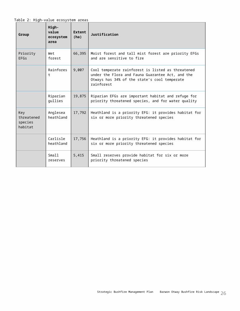
Prioritising these areas does not remove the need to also consider the requirements of threatened species and include measures to reduce the impacts of our fuel management activities in fire operation plans and burn plans.Table 2 shows the landscape’s high-value ecosystem areas, their extent and the main reason we selected them.
Strategic Bushfire Management Plan Barwon Otway Bushfire Risk Landscape 22
Table 2: High-value ecosystem areas
GroupHigh-value ecosystem area
Extent (ha) Justification
Priority EFGs Wet forest 66,395 Moist forest and tall mist forest are priority EFGs and are sensitive to fire
Rainforest 9,007 Cool temperate rainforest is listed as threatened under the Flora and Fauna Guarantee Act, and the Otways has 34% of the state’s cool temperate rainforest
Riparian gullies
19,875 Riparian EFGs are important habitat and refuge for priority threatened species, and for water quality
Key threatened species habitat
Anglesea heathland
17,792 Heathland is a priority EFG: it provides habitat for six or more priority threatened species
Carlisle heathland
17,756 Heathland is a priority EFG: it provides habitat for six or more priority threatened species
Small reserves
5,415 Small reserves provide habitat for six or more priority threatened species
Strategic Bushfire Management Plan Barwon Otway Bushfire Risk Landscape 23
Map 6: Simulated property risk
Strategic Bushfire Management Plan Barwon Otway Bushfire Risk Landscape 24

Fuel management in the Anglesea heathland helps protect AngleseaAnglesea is one of Victoria’s most at risk towns. Bushfires that reach Anglesea may extend some 70 km to the north and 40 km to the west. The town is threatened not just by bushfires, but also by ongoing smoke inundation from peat fires in the Anglesea and Salt Creek river systems, as occurred after the 1983 Ash Wednesday bushfire.Anglesea is surrounded by one of our landscape’s highest priority high-value ecosystem areas, the Anglesea heathland. The Anglesea heathland is one of Victoria’s richest and most biologically diverse vegetation communities.Many plants in the heath’s main EFG—heathland sands—have low canopies, making it more likely that crown fires will occur. Crown fires can create enormous smoke columns. Stringybark eucalypts dominate this EFG and help spot fires develop, which are a major cause of property loss. These factors make the Anglesea area prone to very damaging bushfires in summer (as was demonstrated by the 1983 Ash Wednesday bushfire that destroyed 136 properties), and also prone to bushfires any time from early spring to later in autumn.The heath’s vegetation is highly treatable and DELWP regularly burns parts of the heath to reduce the risk to Anglesea. PHOENIX Rapidfire simulations show that, at present, planned burning has reduced the likelihood of any properties being destroyed by about half, and the number of properties destroyed by 75%. This results in a downgrading of Anglesea’s risk from catastrophic bushfires from high to moderate. The simulations indicate that by 2050, there can be up to a further 10% reduction in the risk to Anglesea, compared with the risk had there been no planned burning.Map 7 shows the change in the percentage of simulated bushfires that would impact on properties at locations in and close to Anglesea, with maximum fuel hazard and 2013 fuel hazard.Planned burning has also reduced the risk of bushfires impacting on the Anglesea power station and coal mine, which are on the northern edge of Anglesea. The current fuel management strategy has reduced the bushfire risk to the power station by 60% and reduced the risk to the coal mine by 30%.Planned burning has reduced Anglesea’s bushfire risk, but has also reduced the ecosystem resilience of parts of the heath. In 2013, 42% of the Anglesea heathland was below its minimum TFI, and 37% was at an early growth stage. DELWP and PV are currently exploring the projected outcomes of different fuel management strategies to identify a regime that best meets the code of practice objectives. We are consulting with the community and agency representatives about the trade-offs between protecting life and property and maintaining or improving ecosystem resilience.
Protecting Lorne and surrounding wet forestLorne, nestled in the forested foothills of the Otway Ranges, is exposed to bushfires that sweep in from the north and double back along the coast from the south-west. On Ash Wednesday, there were times where the bushfire was reported to be coming toward Lorne at over 20 km/h and spot fires were starting 10 km in front of the main fire. Sixty-three properties were destroyed in the northern part of the town.Lorne has a peak summer population of over 20,000 people and tourists and holidaymakers can be particularly unprepared for bushfire.Lorne has the fifth-highest exposure to catastrophic bushfires in our landscape: about 10% of simulated bushfires destroy one or more properties. With no planned burning, about 4% of simulated fires destroy 1000 properties or more. This exposure, and a vulnerable population, makes Lorne one of the most at risk towns in Victoria.With no fuel management, simulations indicate that about 900 properties are destroyed each time the town is impacted by a major bushfire. DELWP’s fuel management has reduced this to about 600 (simulated) property losses, and will further reduce it to 500 by 2050. DELWP’s fuel management strategy consists of planned burning and mulched fuel breaks at the interface of the bushland and the town, to further reduce the fuel hazard.Since 2007, DELWP has frequently undertaken planned burning within 3 km of Lorne and burnt on the northern slopes of the Otway Ranges, to reduce the likelihood of large bushfires developing.Planned burning on the northern slopes of the Otway Ranges also reduces the risk that fire-sensitive wet forest and rainforest will be burnt in a bushfire. For example, under Black Saturday-type conditions (FFDI 130), there is currently only a 5% chance that a bushfire will burn a large amount of the landscape’s wet forest and rainforest.Although there are small areas of wet forest in some planned burning areas, DELWP very rarely burns them: most wet forest is in areas where planned burning is excluded.
Strategic Bushfire Management Plan Barwon Otway Bushfire Risk Landscape 25
Priority infrastructureWe have identified priority infrastructure throughout the landscape that we will protect through our fuel management strategy and other risk mitigation activities. Among our landscape’s most important infrastructure are our water catchments and their associated infrastructure, the Mt Cowley communication tower and the Great Ocean Road.
Water catchments and supply infrastructureHeavy rainfall after bushfires can cause saturated soil to flow down steep gullies and creek lines, creating a debris flow of thousands of tons of rock, logs and other debris. The St George and Painkalac catchments are at most risk of debris flows as a result of major bushfires.DELWP minimises the risk to water quality and quantity in water catchments by working with water corporations on the location and extent of fuel management, and by identifying areas within catchments at high risk from debris flow. Planned burning in 2012 and 2014 in the Painkalac catchment did not disrupt the water supply.
The Gellibrand main pumping station, on the Gellibrand River, is very important water supply infrastructure in a forested area. Several agencies work together to mitigate the risk of bushfire damage to the station and its nearby infrastructure, which could disrupt water supply to Wannon Water customers. This includes:• Wannon Water and CFA conducting burns on surrounding private land, to reduce fuel hazard close to the assets• Wannon Water upgrading and retrofitting parts of the assets to reduce the likelihood of damage by embers and
radiant heat• DELWP nominating planned burns on surrounding public land, to reduce the speed and intensity of major bushfires
that may enter the catchments.
Mt Cowley communication towerMt Cowley communication tower is close to the highest point in the Otway Ranges and is surrounded by forests with an extreme fuel hazard.
State-Net Mobile Radio (the emergency services communication network), the Emergency Services Telecommunications Authority (which provides the 000 emergency services number), Barwon Water and several television and radio stations have communications equipment on the tower. It is essential, life-saving infrastructure for public and emergency services communication at all times, and particularly in the event of a bushfire.Of all essential infrastructure in our landscape, the tower has the highest exposure to damaging bushfires that start under Black Saturday-type weather conditions. While intensive mulching since 2007 has reduced the tower’s exposure to flame contact and radiant heat, the nearby mountains are too steep, and the vegetation too wet, for planned burning to be a viable option near the tower.
Great Ocean RoadThe Great Ocean Road carries heavy traffic at the height of the bushfire season. Much of the road goes through forest, a large proportion of which cannot be treated by planned burning to a level where people could survive by sheltering in their car during a bushfire.
The Great Ocean Road is also the only main road through several of the highest-risk towns (such as Anglesea, Aireys Inlet and Wye River) and is essential infrastructure for the tourism industry.While the current fuel management strategy only marginally reduces the number of simulated bushfires that impact the Great Ocean Road, the strategy does reduce the number of damaging fires that impact longer sections of the road. For instance, it reduces the number of fires that impact more than 5% (13 km) of the total road length by about 30%.The traffic management plan for the Great Ocean Road details actions to be undertaken in the event of a bushfire that threatens the road. DELWP, PV, VicRoads, Victoria Police and local governments review the plan together, each year before the bushfire season. Vic Roads also assesses bushfire risks along the road and does work (such as removing vegetation) to mitigate them.
Strategic Bushfire Management Plan Barwon Otway Bushfire Risk Landscape 26
Strategy and actions to reduce bushfire risk in Barwon Otway
DELWP’s risk mitigation approach is to provide a higher level of protection to the priority towns and infrastructure and high-value ecosystem areas described in the last chapter, while providing a level of protection to other important features of our landscape, consistent with the two code of practice objectives.This strategic bushfire management plan outlines Barwon Otway’s fuel management strategy, which is how DELWP and PV will implement the code of practice objectives. The strategy aims to reduce the chance of major bushfires reaching priority communities (such as Anglesea, Aireys Inlet, Lorne, Wye River and Forrest) and infrastructure, and high-value ecosystem areas, by managing fuel (including on the western, northern and eastern slopes of the Otway Ranges, and close to priority assets) to reduce flame contact, radiant heat and embers.A large amount of the bushfire risk is on private land. We will continue to share information and work with CFA, local governments and other land managers to support action on private land that provides additional risk reduction to communities.All bushfire risk cannot be eliminated through fuel management alone. We have identified a range of bushfire management actions across prevention, preparedness, response and recovery to complement our fuel management strategy and further reduce bushfire risk.Over the next few years, we will work in partnership with communities, stakeholders and other agencies to develop comprehensive bushfire prevention, preparedness, fuel management, response and recovery strategies.
Barwon Otway fuel management strategyAbout fuel management
Planned burning is the deliberate introduction of fire into the landscape to reduce the quantity of leaf litter, twigs, bark and undergrowth. It is the most effective method of fuel management on large areas of public land, and is the main way this plan reduces bushfire risk. We also manage fuel by mulching, applying herbicide, mowing and slashing. Fuel management also serves ecosystem resilience purposes, such as regeneration of plant species and habitat.We undertake fuel management activities where bushfires are likely to start and along the paths they are likely to travel, to reduce their rate of spread, intensity and long-distance spotting potential. We also manage fuels close to and adjacent to priority communities and infrastructure, and high-value ecosystem areas. This helps minimise flame contact, radiant heat, ember generation and short-distance spotting potential.Some parts of the landscape have hot spots—areas where intense convection creates severe flame and ember threats—and critical escalation zones earlier in a bushfire’s path, where crown fire runs can create strong convection and spotting. In some parts of the landscape, these are close to population centres; in others, they are further away. Hotspots and critical escalation zones can accelerate and expand bushfires and reducing fuel hazard in these places is important, to moderate major bushfires.Sizeable areas of our landscape—particularly in the western half of the Otway Ranges—are wet forest, which is generally too wet for fuel management close to priority towns and infrastructure. In these areas, reducing fuel hazard where bushfires are likely to start and spread helps reduce bushfire risk. Burning drier forests on the lower slopes also reduces risk for wet forest and rainforest, including in high-yielding water catchments.
Our strategyIn 2010, DELWP developed a fuel management strategy for Barwon Otway, and began implementing it in 2011. The strategy prioritises fuel management within 3 km of high-risk towns (such as Anglesea, Aireys Inlet, Lorne, Wye River and Forrest). To develop the strategy, DELWP simulated 20 different fuel management strategies to evaluate their effectiveness in reducing bushfire risk to people and property, and maximising environmental outcomes, out to 2050. We looked at a 40-year period because a major bushfire is more likely in that period than
Strategic Bushfire Management Plan Barwon Otway Bushfire Risk Landscape 27
in a shorter period, and a longer period enables a more reliable prediction of ecosystem resilience.
Strategic Bushfire Management Plan Barwon Otway Bushfire Risk Landscape 28

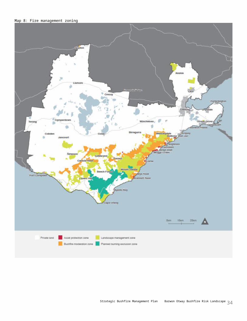
Map 8: Fire management zoning
Strategic Bushfire Management Plan Barwon Otway Bushfire Risk Landscape 29
Our strategy draws on our understanding of where the worst bushfires are likely to start, spread and cause damage to priority assets so as to:• identify areas where fuel management activities should be prioritised• determine the optimal treatment regime (where and when we should undertake fuel management activities) to
effectively reduce risk while maintaining or improving ecosystem resilience.The current fire operations plan shows where, how and when DELWP conducts fuel management.Our strategy seeks to reduce the chance of major bushfires reaching priority communities and infrastructure and high-value ecosystem areas by conducting fuel management in areas:• that will reduce the rate of spread, intensity and long-distance spotting potential of bushfires (such as on the
western, northern and eastern slopes of the Otway Ranges).• close to high-priority assets (such as around Anglesea and Lorne) to reduce flame contact, radiant heat and ember
attack on assets.About 17% (180,000 ha) of the total landscape is treatable by planned burning. This is about 42% (100,000 ha) of public land, and 10% (80,000 ha) of private land. The rest is not treatable by planned burning, either because the vegetation is sensitive to fire, or because it’s physically too difficult to burn. In many instances, planned burns in the landscape need to be conducted in partnership between landholders, CFA, DELWP and PV.In the last 10 years, 11.3% of the public land, and 0.1% of the private land, has been burnt through planned burning.
Fire management zonesMap 8 shows the current fire management zoning of public land. This zoning establishes the primary objective for fuel management in different areas of the landscape. It categorises public land into four fire management zones:• asset protection zone: where intensive fuel management provides the highest level of localised protection to human life
and property by reducing radiant heat and ember attack• bushfire moderation zone: where there is fuel management to reduce the speed and intensity of bushfires, either close
to towns or as they spread through the landscape• landscape management zone: where fuel management is done to reduce fuel hazard, improve ecosystem resilience
and manage the land for particular uses (such as forest regeneration and water catchment protection)• planned burning exclusion zone: where there is no planned burning, mainly to protect particular areas that can’t
tolerate fire.Developing a fuel management strategy involves trade-offs between various considerations. For example, when deciding the size of an asset protection zone, a larger zone may provide more protection but may be more expensive to maintain and require clearing of more native vegetation. A smaller zone may be cheaper, and have less impact on ecosystem resilience, but be less effective at reducing bushfire risk. The middle path can be to have a smaller zone that provides a compromise between mitigating bushfire risk and minimising environmental impacts.
Implementing our strategyDELWP and PV conduct fuel management activities:• in areas where bushfires are likely to start• along the paths bushfires are likely to spread, to reduce their rate of spread, power and long-distance spotting
potential• close to high-priority assets, to reduce bushfires’ power and short-distance spotting potential.The strategy burns, on average, about 8800 ha of native vegetation on public land a year and up to 1,000 ha on private land. DELWP and PV manage vegetation by mulching areas close to houses in high-risk towns, to create buffer zones that have minimal fuel between vegetation and assets. The aim is to minimise flame contact, radiant heat and very short-distance spotting. The strategy treats asset protection zones where they are mulched, every year.It burns a maximum of 3000 ha below its TFI each year, mainly close to towns. Several strategies that DELWP evaluated burnt less area below its TFI but didn’t reduce simulated impacts on property to the same extent.
Strategic Bushfire Management Plan Barwon Otway Bushfire Risk Landscape 30

Map 9: Implementing the fuel management strategy
Strategic Bushfire Management Plan Barwon Otway Bushfire Risk Landscape 31
The strategy aims for a vegetation growth stage mix of one-third early stage, one-third middle stage and one-third late stage by 2050. We will refine this with further simulations of growth stages in the future.Map 9 shows the number of times areas of the Barwon Otway landscape will be burnt over the next 40 years under the fuel management strategy. Fuel management in these areas offers a significant risk reduction to our priority towns and infrastructure, and to high-value ecosystem areas, while aiming to minimise impacts on ecological resilience. These areas are on private and public land, as bushfire risk occurs across the whole landscape. Each year, DELWP produces a three-year fire operational plan. These plans align with the fire management zoning and prioritise areas for fuel management, based on the areas shown in Map 9.We recognise that our planned burning and other fuel management activities can have a range of impacts on communities, infrastructure, economic activity and the environment, and we will continue to identify measures to mitigate these impacts though fire operations planning and burn planning, without compromising the strategic objectives of the burn.DELWP’s Strategic Bushfire Risk Assessment and Strategy Selection project is evaluating the current fuel management strategy, including scheduling options and fuel management alternatives. DELWP may implement a revised fuel management strategy in 2015.
Protecting our catchmentsWater supply catchments and supporting infrastructure provide our drinking water and are priority assets for bushfire planning, particularly the:• Gellibrand and Arkins catchments (which supply towns including Warrnambool, Koroit and Camperdown)• West Gellibrand and Olangalah catchments (which supply Colac)• Painkalac catchment (which supplies Aireys Inlet and Fairhaven)• West and East Barham catchments (which supply Apollo Bay, Skenes Creek and Marengo)• Saint George catchment (which supplies Lorne)• Gellibrand River main pumping station.DELWP will work with water corporations to manage fuel hazard in and around catchments to reduce the intensity of potential bushfires in catchments, to minimise reductions in the yield and quality of the water, and to mitigate threats to water supply infrastructure.
Other fuel management actionsWhere it does not compromise human life and property, we will manage the frequency, intensity, distribution and seasonality of planned burning to maintain or improve vegetation health and threatened species habitat by taking into consideration the history of planned and unplanned fire in the landscape.We will work with other agencies to build understanding and acceptance by tourists and the tourism sector of the purpose of fuel management, and of fire being a natural feature of Australian ecosystems.We will work with other agencies (such as CFA and local governments) and landholders to implement our fuel management strategy.We will work with timber plantation and private native forest managers on fuel management to reduce risks to, and posed by, timber plantations and private native forest resources.We will coordinate our fuel management strategy with those engaged in domestic firewood collection, minor forest produce harvesting, grazing, apiculture, mineral exploration and mining, as required.We will involve traditional owners in fuel management planning so they have opportunities to use fire for traditional purposes (for example, to maintain hunting grounds and other cultural heritage sites, and to propagate plant species), and so cultural heritage values are considered in fuel management activities.
What we expect to achieveReduced bushfire riskFigure 2 shows that since 2003, mainly as a result of fuel management, we have reduced residual risk across the landscape to about 60%. PHOENIX Rapidfire simulations predict that full implementation of the fuel management strategy could theoretically reduce residual risk in our landscape to under 50%.Our fuel management strategy reduces, but does not eliminate, bushfire risk on public land. Fuel management in many areas of public land cannot be undertaken because they are inaccessible, it is not safe to do so, or for other operational reasons.
Strategic Bushfire Management Plan Barwon Otway Bushfire Risk Landscape 32
We will further reduce risk by raising awareness and working in partnership with other agencies, private land managers, other key stakeholders and local communities to:• reduce risk on private land• develop and implement actions to prevent bushfires, to be prepared for them before they occur, to respond to and
recover from them if they occur.There will always be vegetation (that is, fuel hazard) on public and private land that cannot be treated through fuel management. This highlights the importance of complementary bushfire prevention, preparedness, response and recovery actions.Figure 3 shows the average modelled total property loss for the 10 most at risk communities in the landscape. It shows estimated properties lost in each town if there had never been planned burning; how things were in 2013; and as they will be in 2050, under the proposed fuel management strategy.Since fuel management activities increased in 2007, the risk has been reduced to Anglesea by 79%, to Lorne by 35%, and to Yeodene by 62%. Continued planned burning to 2050 sees a reduction in risk for Lorne (53%), Fairhaven (86%), Aireys Inlet (68%) and Forrest (35%).The figure shows that we expect all towns except Bellbrae to have less risk in 2050 than in 2013. Our fuel management strategy has already reduced Bellbrae’s risk to a large extent and it will maintain bushfire risk around this level.
Figure 2: Residual risk, 1980–2050
Strategic Bushfire Management Plan Barwon Otway Bushfire Risk Landscape 33
Strategic Bushfire Management Plan Barwon Otway Bushfire Risk Landscape 34
Figure 3: Average modelled property losses in highest-risk towns, by maximum, 2013 and 2050 fuel hazard levels
Fuel management on private landThere is bushfire risk across the landscape, on both public and private land. The fuel management strategy, as well as identifying priority fuel management areas on public land, also identifies private land where fuel management would significantly reduce residual risk. DELWP will support other agencies (mainly CFA, local governments and water corporations) and landowners to prioritise and focus their fuel management activities on the highest-priority areas. Local governments can also use the strategy when making plans to manage bushfire risk on private land.PHOENIX Rapidfire simulations indicate that residual risk can be reduced by up to a further 10% by fuel management on private land.
Ecosystem resilienceThe fuel management strategy burns a maximum of 3000 ha below its TFI in any one year. Although this increases the risk of change in the vegetation in burnt areas if they are repeatedly burnt, we consider it achieves an acceptable balance between reducing bushfire risk to life and property and maintaining ecosystem resilience across the landscape.Figure 4 shows (the orange line) the percentage of the landscape below minimum TFI between 2000 and 2013, and the projected percentage (the dotted line) to 2050. It shows that in the years after 2000, the area below minimum TFI fell as tall mixed forest burnt in 1983 remained unburnt. The area below minimum TFI grew slightly as a result of bushfires in 2005 and 2006, then as a result of increased planned burning. In 2014, 18% of our landscape was below minimum TFI. This is projected to rise to 25% in 2017 before falling as the tall mist forest burnt in the 1939 bushfire reaches its minimum TFI (80 years after the bushfire). The percentage is projected to stabilise at about 16–18%. Figure 4 also shows (as bars, using the right scale) the number of hectares burnt by bushfires and planned burning (from 2001 to 2014), and planned to be burnt (to 2050) under the fuel management strategy.
Strategic Bushfire Management Plan Barwon Otway Bushfire Risk Landscape 35

Figure 4: Percentage of landscape below minimum TFI and hectares burnt, 2001–50
Other bushfire management actionsAs well as implementing our fuel management strategy, we will also undertake prevention, preparedness, response and recovery actions on public land, to further reduce bushfire risk and promote ecosystem resilience.DELWP will continue to share bushfire risk information and work in partnership with other agencies (including CFA, local governments and Victoria Police) to strengthen bushfire management across the whole landscape.
Preventing bushfiresPrevention actions minimise the occurrence of bushfires, particularly those started by people, when weather conditions are extreme.To improve bushfire prevention, DELWP will:• prioritise compliance activities (including community education and enforcement patrols) on days of high fire danger
in worst-ignition areas, to reduce ignitions• share bushfire risk analysis with local governments, other emergency services agencies, land managers and
community-based planning forums to inform bushfire prevention activities on private land• work with other agencies (such as CFA and Victoria Police) to identify and implement ignition reduction strategies
(such as to minimise the lighting of fires).Strategic Bushfire Management Plan Barwon Otway Bushfire Risk Landscape 36
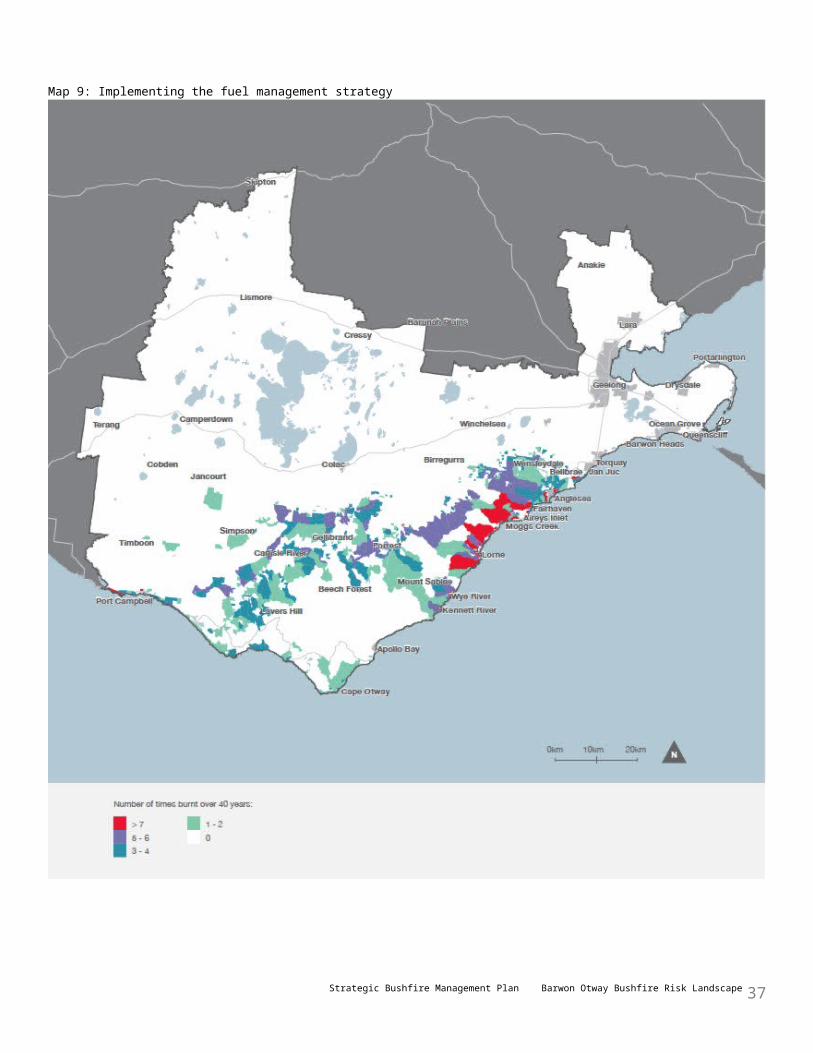
Being prepared for bushfires
We must be adequately prepared for bushfires, to improve our response to them when they occur.
Community awarenessTo improve community awareness and preparedness for bushfires, DELWP will:• provide information, including through fire learning networks, community fireguard groups, community forums and
groups so people understand, and can make decisions based on knowledge of, their bushfire risk• continue to increase and improve communication and engagement with Victorian communities, including through
better use of online tools, and prioritise engagement activities in high-risk communities• work collaboratively with relevant agencies and local governments to build community understanding of bushfire risk
by providing information to at risk communities, agencies and managers of community infrastructure (such as schools, hospitals and aged care facilities).
Roads and tracksWell-maintained roads and tracks are essential for quick response, and for community and firefighter safety. Strategic roads and bridges are important: they allow access for heavy firefighting machinery, safe access for bushfire response and a safe environment for planned burning.To improve the public land road and track network, DELWP will manage our public land strategic road and bridge network to the agreed standards for bushfire management, and ensure road maintenance budgets are prioritised consistent with this.
Emergency management planning• Each year, before the bushfire season, DELWP and CFA will jointly assess the bushfire risk on public and private land
across the landscape to identify priority areas for response, fuel management and community engagement; and update working arrangements for the control of bushfires.
• DELWP and PV will review and revise emergency management plans for the planned closure, evacuation and protection of priority visitor sites (including camping sites, walking tracks, and day-use areas) where people may be at risk from bushfire.
• DELWP will work with relevant agencies and infrastructure managers to develop and implement bushfire mitigation actions for infrastructure identified as at high or extreme bushfire risk.
• DELWP will provide bushfire risk information to Victoria Police, local governments and CFA to assist them to develop evacuation plans for priority communities and locations, including traffic management on arterial and tourist routes (such as the Great Ocean Road).
• DELWP and PV will develop and maintain staff capability in bushfire management, including emergency response.• DELWP will work in partnership with other agencies (including Emergency Management Victoria, CFA, local
governments and Victoria Police) to include strategic risk analysis and PHOENIX Rapidfire simulations in municipal and regional fire and emergency management planning.
Keeping vegetation and habitat healthy• DELWP will identify and update our knowledge of the landscape’s vegetation, so information about the most
vulnerable vegetation and threatened species habitat informs our planning and responses.
Responding to bushfires
DELWP is responsible for suppressing fires in state forests, national parks and protected public land.To improve bushfire response, DELWP will:• continue to provide an integrated response to bushfires with CFA and emergency management partners• share bushfire risk assessment data with other fire agencies and land managers (such as CFA, Barwon Water and
Wannon Water) to support bushfire suppression• continue to validate priority assets and pre-deploy resources on days of high fire danger
Strategic Bushfire Management Plan Barwon Otway Bushfire Risk Landscape 37
• investigate developing a bushfire response strategy, to prioritise bushfire response activities that include community warnings and advice.
Recovering from bushfires
DELWP is responsible for the recovery of public land after a bushfire.
Reducing bushfire impactsTo improve bushfire recovery, DELWP will:• plan and implement emergency stabilisation and rehabilitation actions to manage priority risks to water supplies
posed by altered flow regimes, erosion, debris flows, sedimentation and altered nutrient levels resulting from major bushfire events
• address recovery priorities to re-establish access to public land in a timely manner, and support bushfire-impacted communities to return to normal daily life.
Working in partnershipTo improve bushfire recovery, DELWP will work with other agencies (such as local governments, emergency management planning committees, industry and tourism bodies) and the community to develop contingency plans to maintain a viable tourism industry in the event of a major bushfire.
Monitoring, evaluation and reportingDELWP is soon to release the Monitoring, Evaluation and Reporting Framework for Bushfire Management on Public Land, which will guide how we assess the effectiveness of our management strategies and activities across Victoria in achieving the two code of practice objectives.Monitoring, evaluation and reporting are essential tools for quantifying the effectiveness of our fuel management strategy, and for informing decisions to implement it. This adaptive management approach is important to how we improve bushfire management planning.The framework includes statewide priorities for monitoring, evaluation and reporting, which are to:• measure the effectiveness of fuel management activities in reducing risk to life and property and maintaining or
improving ecosystem resilience• measure the effectiveness of the strategic bushfire management planning process• measure how well the framework supports and improves fuel management activities and effectiveness.These priorities will inform our fire monitoring program across the state. We will aggregate the data collected in our landscape with other data to support reporting against both landscape and state objectives.
Monitoring and evaluationMonitoring activities in Barwon Otway will be informed by the statewide monitoring, evaluation and reporting framework and will:• measure changes to residual risk by assessing fire severity and fuel hazard• measure changes to ecosystem resilience by assessing key habitat attributes and key flora and fauna in high-value
ecosystem areas.We will use the information collected about fuels, fire severity, habitat and ecosystem resilience to:• evaluate the extent to which the fuel management strategy has reduced the impact of bushfires on communities and
ecosystem resilience• refine and improve the models on which the simulations are based.Evaluation enables more informed decisions, and learning and improvement over time.In the next 12 months, DELWP will develop a monitoring, evaluation and reporting implementation plan for the landscape. It will:• evaluate the effectiveness of the fuel management strategy in reducing bushfire risk to priority towns
Strategic Bushfire Management Plan Barwon Otway Bushfire Risk Landscape 38
(such as Anglesea and Lorne)• monitor how the fuel hazard changes and re-accumulates after burning the EFGs which will help us to better
simulate bushfire risk• evaluate the effectiveness of the fuel management strategy for maintaining vegetation and growth stage diversity in
high-value ecosystem areas• monitor risk to ecosystem resilience in areas that may be burnt below their TFI, particularly in the Anglesea
heathland.
ReportingReporting ensures transparency and shares knowledge about bushfire management. DELWP will report:• annually, on fuel management activities (in its fuel management report)• every five years, on the effectiveness of the fuel management strategy and other actions in this plan• at least every ten years, on achievement of the two code of practice objectives.Under DELWP’s Bushfire Science Strategy 2013–17, we will invest in research to improve the information available for this and future plans. We plan to improve our risk assessment methodology by incorporating a variety of weather patterns, convection strength and better measures for ecosystem resilience and environmental values.
ReviewDELWP and PV want bushfire management to evolve to a state where monitoring, evaluation and reporting is a continuous process that leads to improved versions of this plan. Improvement of the fuel management strategy and other actions in this plan will be driven by monitoring and evaluation of:• their effectiveness in reducing bushfire risk and maintaining ecosystem resilience• the impacts of major bushfires or other major events• improved science, technology and community knowledge.Over the next few years, we will work in partnership with communities, stakeholders and other agencies to develop a more comprehensive range of bushfire prevention, preparedness, fuel management, response and recovery actions on public land.
Strategic Bushfire Management Plan Barwon Otway Bushfire Risk Landscape 39